Embed Size (px)
Citation preview

EB
PauAdaVirg
GEOLOGYOF THE
TAOS REGION
New MeXicofillyAfth Annu
Septemb
ditorsrian S.
Bristerl W. Bauer
m S. Readil W. LuethGeOlogical Societyal Field Conferenceer 22-25, 2004

CONTENTS
Dedication ................................................................................................................................................................................................................... ivPresident's Message……………………………………………………………………………………………………………………………………vEditors' Message ............................................................................................................................................................................................................................................ ................................................................ ................................................................ ........................................ viCommittees ................................................................................................................................................................................................................ viiField Conference Schedule …………………………………………………………………………………………………………………………viii
ROAD LOGS
THE TAOS PLATEAU AND Rio GRANDE GORGE - First -day road log from Taos to Questa, the Wild Rivers Recreation Area,Arroyo Hondo, the Dunn Bridge, the Rio Grande Gorge Bridge and return to Taos....................................... Adam S. Read, Paul W. Bauer, Ren A. Thompson, Keith I. Kelson, and William R. Muehlberger 1
MINIPAPERS
Molycorp tailings facility, Questa, New Mexico .................................................. Virginia T McLemore and Anne Wagner 8Alteration scars in the Red River Valley, Taos County, New Mexico
.................................................................................................. Virginia T McLemore, Virgil W Lueth, and Bruce M Walker 19Proterozoic tectonic history of the Taos Range ...............................................................................................Jane P Dawson 22Potential interaction of sustainable development and aggregate production with an example from Taos,
New Mexico, USA........................................................................................................................................ James M. Barker 34
THE FLANKS OF THE RIFT - Second-day road log from Taos to Taos Pueblo, Llano Quemado, Pilar and
return to Taos ....................Paul W Bauer, Adam S. Read, Keith I. Kelson, William R. Muehlberger, and Daniel J. Koning 37MINIPAPERS
Kit Carson Memorial Park and Cemetery ................................................................................................ Virginia T McLemore 53Laramide to post-Laramide cooling history of the Miranda Graben...............................................................Shari A. Kelley 61There's gold in them cliffs...or is there? The fleeting (and fleecing?) Glen-Woody mining venture ......... Paul W Bauer 69An overview of the current bark beetle infestation in New Mexico's upland forests ............................ David J. McCraw 75
THE SAN LUIS BASIN TO THE ESPASIOLA BASIN - Third-day road log from Talpa to the Rio Grande del Rancho Valley,
U.S. Hill, Vadito, and Periasco ........................................................................Paul W. Bauer, Adam S. Read, Keith I. Kelson,Barry S. Kues, Scott B. Aby, William R. Muehlberger Ren A. Thompson, George S. Austin, and Gary A. Smith 77
MINIPAPERS
Paleontology of the upper Flechado Formation near Talpa, north-central New Mexico .............................. Barry S. Kues 79Commercial muscovite from the U.S. Hill mine, Picuris Mountains, Taos County, New Mexico
..................................................................................................................James M Barker Ken Santini, and George Austin 90
PESIASCO TO ESPASJOLA - Third-day supplemental road log .................................Daniel J. Koning, Gary A. Smith, and Scott B. Aby 99MINIPAPERS
Geology of the escarpment north of the Santa Cruz River, eastern Espanola Basin,and inferences regarding rift tectonism in the Miocene............................................................................Daniel J. Koning 103
APPENDIX 1 - Road Log GPS Waypoints ............................................................................................................................................................... 108
ROAD LOG REFERENCES .................................................................................................................................................................................. 109
COLOR PLATES
Eleven color plates that supplement the road logs and articles ........................................................................................................................ 113
A R T I C L E S
Structure and Tectonics
Cenozoic structural development of the Taos area, New Mexico ............................................................. P W Bauer and K.I. Kelson 129Late Quaternary characteristics of the northern Embudo fault, Taos County, New Mexico
.............................................................................................................................. K.I. Kelson, P.W. Bauer J.R. Unruh, and J.D.J. Bott 147Geologic structure of the Vclarde graben and the southern Embudo fault system,
north-central New Mexico......................................................... D.J. Koning, J.F. Ferguson, P Jackson Paul, and W.S. Baldridge 158
ii

Rift extension and fault slip rates in the southern San Luis Basin, New Mexico........................................ P. Bauer and K.I. Kelson 172Evolution of the southeastern San Luis Basin margin and the Culebra embayment, Rio Grande rift,
southern Colorado ................................................................................................................................................................ A.R. Wallace 181Proterozoic rocks of the Pilar cliffs, Picuris Mountains, New Mexico .................................................................................P.W. Bauer 193Unconformable and cross-cutting relationships indicate major Precambrian faulting on the
Picuris-Pecos fault system, southern Sangre de Cristo Mountains, New Mexico..................... S.D. Fankhauser and E.A. Erslev 206Structural and stratigraphic development of the Miranda graben constrains
the uplift of the Picuris Mountains ............................................................................................... D.W. McDonald and K.C. Nielsen 219
Geophysics
Gravity and aeromagnetic expression of tectonic and volcanic elements of the southernSan Luis Basin, New Mexico and Colorado ...................................................................................... V.J.S. Grauch and G.R. Keller 230
Preliminary interpretation of high-resolution aeromagnetic data collectednear Taos, New Mexico .......................................................................................................V.J.S. Grauch, P. Bauer, and K.I. Kelson 244
Structure of the Sangre de Cristo Mountains between Taos and Mora basedon an integrated geophysical analysis ......................................................................... 0. Quezada, C. Andronicos, and G.R. Keller 257
Rootless mountains and gravity lows in the Sangre de Cristo Mountains,southern Colorado-northern New Mexico................................................L. Trevino, G.R. Keller, C. Andronicos, and 0. Quezada 264
Geological training of astronauts in the Taos region ……………………………………………………………..W.R. Muehlberger 272Field geophysical training of astronauts in Taos Valley — A brief synopsis ……………………………………………………………...P W Dickerson 278
Quaternary Geology and Geomorphology
Erosional retreat of a river-damming debris flow on the Rio Grande, Taos County, New Mexico ..................................P W. Bauer 282Initial paleoseismic and hydrogeologic assessment of the southern Sangre de Cristo fault at the Taos Pueblo
site, Taos County, New Mexico .................... K.L Kelson, P W Bauer, S.D. Connell, D. W Love, G.C. Rawling, and M Mansell 289Plio-Pleistocene incision history of the Rio Ojo Caliente, northern Espanola Basin, and overview of the
Rio Grande system in northern New Mexico .............. D.L. Newell, D.J. Koning, K.E. Karlstrom, L.J. Crossey, and M. Dillon 300
Stratigraphy, Sedimentology and Paleontology
Tectonically induced elastic-carbonate depositional sequences of the Pennsylvanian-Permiantransition in the Rowe-Mora basin, northern New Mexico ...................................................K. Kramer S.G. Lucas, and B.S. Kues 314
Pennsylvanian trilobites from the Sangre de Cristo and Jemez Mountains, north-central New Mexico ............................ B.S. Kues 326The Picuris Formation: A late Eocene to Miocene sedimentary sequence
in northern New Mexico ...............................................................................................................S.B. Aby, P. Bauer, and K.1. Kelson 335Sedimentology of the Tesuque Formation and tectonics of the Embudo fault system near
Dixon, New Mexico ......................................................................................................................................... S.B Aby and D.J. Koning 351Middle-upper Miocene stratigraphy of the Velarde graben, north-central New Mexico:
tectonic and paleogeographic implications ........................................................................... D.J. Koning, S.B. Aby, and N. Dunbar 359Subsurface stratigraphy in the southern San Luis Basin, New Mexico...................................................................................
....................................................................... P Drakos, J. Lazarus, J Riesterer, B. White, C. Bonet, M. Hodgins, and J. Sandoval 374
Economic Geology
Mineral resources in Taos County, New Mexico .............................................................................. V.T. McLemore and K.E. Mullen 383
Hydrogeology and Hydrology
Hydrologic characteristics of basin- fill aquifers in the southern San Luis Basin, New Mexico ..................................................................................................................... P Drakos, Lazarus, B. White, C. Bonet, M. Hodgins, I Riesterer, and J. Sandoval 391
Chemical and isotopic constraints on source-waters and connectivity of basin-fill aquifersin the southern San Luis Basin, New Mexico ...................................P Drakos, K. Sims, J. Riesterer, I Blusztajn, and J. Lazarus 405
Subsurface temperature logs in the vicinity of Taos, New Mexico ...............................................................M Reiter and J. Sandoval 415Groundwater geology of Taos County ...................................................................................................................................... A.L. Benson 420Taos regional groundwater flow model ..........................................................................P Burck, P Barroll, A. Core, and D. Rappuhn 433
iii

iv DEDICATION
WILLIAM R. MUEHLBERGER
Although Bill Muehlberger has neverconfined himself to one state, one country, onecontinent, or one celestial body, New Mexicohas seen his Brobdingnagian boot-prints fromthe 1940s to the present. The fascination beganwhen he was an irreverent undergraduate fieldassistant (to Dick Jahns) in the Ojo Calientepegmatite district and a teaching assistant (forLloyd Pray) at the California Institute ofTechnology field camp in the SacramentoMountains. Since then, he has mapped andconducted research in the Hillsboro lead-silverdistrict, the Chama region, the Clayton-Ratonvolcanic field, the Tusas and PicurisMountains, the Taos Plateau, and the southernSan Luis Basin. Results of those efforts haveappeared
in NMGS and NMBGMR publications,including this volume. Three Ph.D. and thirteen M.A. studentshave worked here under his supervision, braving localinsurrections, overturned vehicles, and sundry other character-building experiences.
Bill instructs astronauts in field geology at Apollo 15 trainingsite on Rio Grande gorge rim in May 1999.
Construction of his own character included a year studying civilengineering at the University of California at Berkeley, where healso reigned as Intramural Heavyweight Wrestling Champion. Hisgeological schooling (B.S., 1949; M.S., 1949; Ph.D., 1954) was atCaltech, where he achieved distinction in both academic andathletic arenas: outstanding senior of his class, co-developer ofthe flush seismograph, and fullback of the football team. Hiscollegiate career was punctuated by stints in the Marine Corps(1942-46, 1950-52) and culminated in doctoral work in SierraPelona and the Soledad Basin.
He then strode out of southern California, Ph.D. in hand andbolo around his neck, to begin a 50-year affiliation with theUniversity of Texas at Austin – as professor, chairman, and nowprofessor emeritus in the Department of Geological Sciences. Hisresearch and that of his 84 graduate students have resulted inhundreds of publications, and his distinguished teaching ineightawards and endowed professorships. Continent- and hemisphere-
scale projects reflect the scope of his thinking– he directed production of the first BasementRock Map of the United States (USGS, 1968)and compiled the most recent Tectonic Mapof North America, grounded in plate tectonicsconcepts (AAPG, 1996).
Beyond the continents and hemispheres ofEarth, others of Bill's students haveconducted field studies on the Moon. TaosPlateau and the Rio Grande gorge providedexcellent geological analogues to features nearApollo mission landing sites. Bill was principalinvestigator for geology for the Apollo 16 and17 missions (Muehlberger, 2004, this volume),and since then has continued to instructastronauts in Earth observations from Skylab,Apollo-Soyuz, Space Shuttle, and the
International Space Station. Two NASA medals attest to hiscontributions to astronaut and public instruction in geological andsolar system exploration: the 1973 Medal for ExceptionalScientific Achievement and the 1999 Public Service Medal.
Space explorers and schoolchildren, teachers and graduatestudents, retirement home residents and youth groups – legionsof us throughout the world can state that Bill Muehlberger haschanged the way in which we view our planet.
— Patricia Wood Dickerson
Bill test drives an Apollo exploration backpack and lunarsampling tool in the 1960s.

PRESIDENT'S MESSAGE
The 55th New Mexico Geological Society Fall Field Con-ference will be held in the Taos region, previously visited byNMGS in 1966, 1984, and 1990. This year the trip organizeris Paul Bauer, of the New Mexico Bureau of Geology andMineral Resources. He and many others will be leading us throughthe Cenozoic geology of the southern San Luis Basin, focusing onvolcanic activity, faulting, landscape evolution, and sedimentation.An important aspect of this trip is to highlight discoveries madeduring recent mapping in the area as part of the STATEMAPproject. These include a new understanding of the evolution of theSangre de Cristo and Embudo fault zones, which we will visit onDay Two.
Guidebook editors Brian Brister, Paul Bauer, Adam Read, andVirgil Lueth have done a superb job with the guidebook articles,and we appreciate their efforts as well as those of the manyauthors who experienced a somewhat more rigorous round ofediting this year. Virgil Lueth, a Past President of NMGS and co-Chair of the 2002 Field Conference, graciously agreed to be themanaging editor this year. Virgil has made some improvements tothe layout and presentation of the text and images in theguidebook. Each year our guidebooks get better and better. All 55of them remain in print.
The New Mexico Geological Society has undergone some-what of a transformation over the past year and 1 would like totake this opportunity to update you on these changes. Becausethe non-profit status of NMGS, Inc. was threatened by thegrowth of some of our investments, the Executive Committeerecommended the creation of a separate foundation that would beresponsible for the scholarship accounts. At the end of 2003, theNMGS membership voted to create the NMGS Foundation andas of early 2004 all of the NMGS scholarships (such as Grants-in-Aid, Pipkin Undergraduate Research Awards, Pipkin SeniorScholarships, and several others) will be paid from theFoundation Accounts to recipients recommended by NMGS,Inc. committees. The Board of the NMGS Foundation, currentlyheaded by Paul Catacosinos, has four other members including theVice-President of NMGS, Inc. Brian Brister, Maureen Wilks, andGary Stephens played an integral role in creating the Foundationand they are thanked for the many hours of their time ensuringthat the financial future of the Society is no longer in jeopardy.
I would also like to thank several other people who generallywork behind the scenes to make this Society successful. Mau-reen Wilks, who is currently the Publications Chair, is managingthe publication of the new Geologic Highway Map. Adam Readhas been the society Webmaster for several years and hasrecentlyupdated our website (http://geoinfo.nmt.edu/nmgs). BobMyers has served as the chair of the Scholarship Committee for
many years. Theresa Lopez helps with registration at the Springand Fall Meetings, sells our publications, and in addition tomany other duties, is the first point of contact to the outsideworld. Many thanks to all of you and to any others I may haveoverlooked.
The relationship between NMGS and the New Mexico Bureauof Geology and Mineral Resources remains strong. We recentlysigned a Memorandum of Agreement with the Bureau thatformalizes our relationship. We thank Peter Scholle and theBureau for their continued support.
Once again, the scholarships awards were increased fromprevious years. The Executive Committee has recommended thatover S37,000 be given for various scholarships this year, anincrease of about $5000 from last year. We continue to offer freemembership in the Society and discounts on publications forundergraduate and graduate students at New Mexico universities,and we are pleased with the increase in student participation atboth the Fall Field Conferences and the Spring Meeting.
Sean Connell, Peter Fawcett, and John Sigda chaired the SpringMeeting this year. The theme was Landscape Evolution andfeatured a keynote presentation by Vance Holliday. Many thanksgo to all of the volunteers, especially Theresa Lopez who helpedwith the on-site registration.
After many years of preparation, we look forward to publica-tion this summer of the New Mexico Geological Society SpecialVolume "The Geology of New Mexico," edited by Greg Mack,Kate Giles, and George Austin. This will be the definitive text onour current understanding of the geologic evolution of NewMexico. Soon to follow will be the publication of the completelyupdated New Mexico Geologic Highway Map.
The 2005 Fall Field Conference will be held in the Chama/Ghost Ranch area, and 2006 will be based in Carlsbad. 2007will mark a return to the Jemez Mountains and in 2008 we willvisit the Gila Wilderness area. As always, we encourage par-ticipation from our membership in any capacity, whether writingguidebook articles or road logs, leading field trips, runningmeetings, contributing ideas for improvements to the Society, orserving on the Executive Committee of either NMGS, Inc. or theNMGS Foundation. On a personal note, I appreciate all of theefforts by those who were involved this past year and especiallythose who have contributed to help make this year's conferencesuccessful.
Jeffrey M Amato
V

EDITORS' MESSAGE
We return to Taos after a 20-year hiatus. On the 1984 fieldconference, participants circumnavigated the Picuris Mountainson Day 1, explored high into the Sangre de Cristo Mountainson Day 2, and crossed the rift into the Tusas Mountains on Day3. This year, the focus of the conference is quite different. Wespend all of the first two days investigating the southern SanLuis rift basin. On Day 1 (6 stops, 107 miles), we trace the dra-matic Rio Grande gorge, stopping periodically to delve into thegeologic history of the sedimentary and volcanic materials that fillthe rift and the geomorphic history of the Rio Grande and itstributaries. On Day 2 (5 stops, 49 miles), we plot a course alongthe southeast boundary of the basin, tracking the structurallycomplex transition from the master rift fault zone to the riftaccommodation zone. On Day 3 (3 stops, 23 miles), we cross fromthe San Luis to Espanola Basins, stalking elusive pre-rift structuralbasins and their spectacular sedimentary sequences.
The roadlogs and papers in this guidebook and the field con-ference presentations highlight a vast body of new geologic dataemerging from the Taos area. The new studies can be roughlydivided into three general efforts, although all are connected andsomewhat collaborative.
1) Geologic Mapping: Since 1996, the New MexicoBureau of Geology & Mineral Resources (NMBGMR)STATEMAP program has been producing geologic quad-rangle maps of southern Taos County. Six new quads in theTaos area have yielded a tremendous bounty on the geometryof the rift basin, the kinematic and paleoseismic histories ofthe Sangre de Cristo and Embudo fault zones, the stratigraphyof Pennsylvanian rocks, the significance of the pre-rift PicurisFormation, the hydrogeology of the basin, the Quaternarygeomorphic history of the Taos Plateau, and the pre- to post-incision history of the Rio Grande. Several new quads thatstraddle the transition zone between the San Luis andEspanola Basins have revealed the geometry and kinematicsof the rift accommodation zone, the depositional history ofthe Santa Fe Group, and the hydrostratigraphy of basin-fillsediments.
2) Geophysics: The second new data set is the high-resolution aeromagnetic survey of the Taos area in 2003.The acquisition of the data represent the best in interagencycooperation; the study was cooperatively planned by scientistsfrom the USGS and NMBGMR, and financed by contri-butions from the Town of Taos, Taos County, U.S. Bureau ofIndian Affairs, Taos Soil & Water Conservation District, U.S.Bureau of Reclamation, and the Office of the State Engineer.The processed aeromag imagery, which is currently beingintegrated into a subsurface geologic model, is revealingfantastic structural and stratigraphic complexities that areconfirming some existing hypotheses and disproving others.
3) Hydrogeology: The third data set is a consequence ofwork surrounding the availability, quality, and adjudicationof water in Taos County. A spate of studies and initiatives haveresulted in the creation of some terrific new hydro-logicresources; the State Engineers Office has developed ahydrologic model that is based on our latest understanding of
the stratigraphy and structural geology, the Soil & WaterConservation District has assembled a massive database
of Taos County water wells, the U.S. Bureau of Reclamationfunded the drilling and hydrogeologic analysis of six deep wellsin the Taos area, the county has instigated a Taos CountyRegional Water Plan, and private consultants have compiled avast amount of hydrologic data.You will notice that few of the guidebook papers are reviews
of older, established geologic themes. Instead, this guidebook isfilled with papers that present new data and interpretations for thefirst time in print. Similarly, the roadloggers have loaded the logswith fresh information and provocative ideas. You will also notethat we have instituted a makeover of the traditional NMGSguidebook format. A 16-page color signature has allowed us toincorporate a variety of new images, maps, and cross sections. Theroadlogs now clearly demark each stop and each individual topicof discussion at each stop is summarized in a distinct sub-section.We have also established gray-shaded sidebars that summarizetopics of special interest that are encountered outside of thestops. Minipapers have been set into the logs as separate, full-pagedocuments complete with reference lists. We also took advantageof GIS software to generate figures that place geologic data into aspatial framework, often using a shaded relief base rather than atopographic contour base. Waypoint coordinates of stops andmajor intersections are included for those of you that like tonavigate with GPS units. Finally, nearly every stop isaccompanied by a digital panoramic image or orthophotographicindex map. We hope that these upgrades enhance your guidebookexperience.
We earnestly thank all of the following for their contributionsto this volume and to the field conference. Brigitte Felix Kludtdevoted her artistic talents to improving hundreds of the figuresin this book and designed the picturesque cover. Elise Colvin (Bsc,PE, CSM) provided original artwork for open space within theguidebook. Dave McCraw ably assisted with the production ofcopious color and black & white figures. Sandi Azevedo and KathyGlesener cheerfully endured drafting of the monstrously detailed,page-sized, black & white geologic maps found in the roadlogs.Mark Mansell stoically worked on GIS tasks for the regionalgeologic map, and Glen Jones performed other bits of GISwizardry. We salute all of the authors, reviewers, and roadloggersfor their expertise, professionalism, and dedication to furtheringthe educational and scientific goals of the New Mexico GeologicalSociety. Finally, we acknowledge the New Mexico Bureau ofGeology and Mineral Resources and its director Peter Schollefor steadfast support of the production of this guidebook.
Paul Bauer Brian Brister Adam Read Virgil Lueth
vi
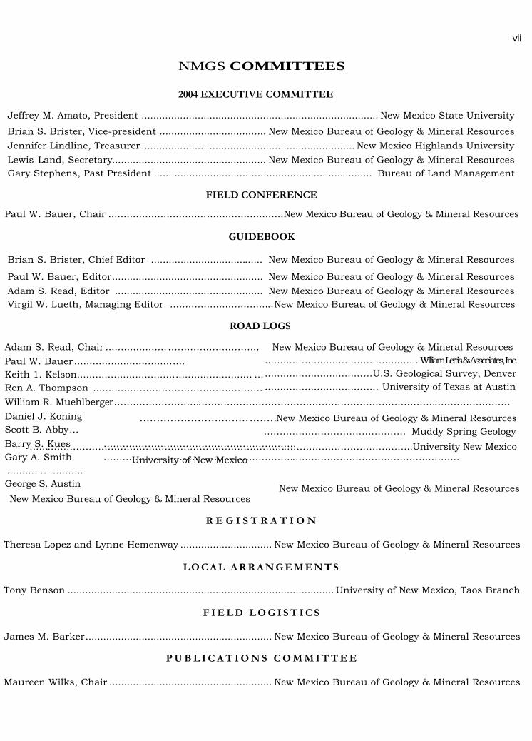
NMGS COMMITTEES
2004 EXECUTIVE COMMITTEE
Jeffrey M. Amato, President ................................................................................ New Mexico State University
Brian S. Brister, Vice-president .................................... New Mexico Bureau of Geology & Mineral ResourcesJennifer Lindline, Treasurer ........................................................................ New Mexico Highlands UniversityLewis Land, Secretary.................................................... New Mexico Bureau of Geology & Mineral ResourcesGary Stephens, Past President .......................................................................... Bureau of Land Management
FIELD CONFERENCE
Paul W. Bauer, Chair .........................................................New Mexico Bureau of Geology & Mineral Resources
GUIDEBOOK
Brian S. Brister, Chief Editor ...................................... New Mexico Bureau of Geology & Mineral Resources
Paul W. Bauer, Editor................................................... New Mexico Bureau of Geology & Mineral ResourcesAdam S. Read, Editor .................................................. New Mexico Bureau of Geology & Mineral ResourcesVirgil W. Lueth, Managing Editor ..................................New Mexico Bureau of Geology & Mineral Resources
ROAD LOGS
Adam S. Read, Chair ....................………………………..Paul W. Bauer ....................................Keith 1. Kelson......................................................... …Ren A. Thompson .........………………………………………William R. Muehlberger………………………………………………………………………………………………………………Daniel J. KoningScott B. Abby…Barry S. Kues …………Gary A. Smith ………….........................George S. Austin
New Mexico Bureau of Geolo
New Mexico Bureau of Geology & Mineral Resources.................................................. WilliamLettis&Associates,Inc....................................U.S. Geological Survey, Denver..................................... University of Texas at Austin
………………………………U
Theresa Lopez and Lynne He
Tony Benson .........................
James M. Barker..................
Maureen Wilks, Chair ..........
vii
........................................New Mexico Bureau of Geology & Mineral Resources
………………………………………….………………………………………………………………………………………..
gy & Mineral Resources
……………………………………… Muddy Spring Geology
…………………………………………………………………………..University New Mexiconiversity of New Mexico
New Mexico Bureau of Geology & Mineral Resources
R E G I S T R A T I O N
menway ............................... New Mexico Bureau of Geology & Mineral Resources
L O C A L A R R A N G E M E N T S
................................................................. University of New Mexico, Taos Branch
F I E L D L O G I S T I C S
............................................. New Mexico Bureau of Geology & Mineral Resources
P U B L I C A T I O N S C O M M I T T E E
............................................. New Mexico Bureau of Geology & Mineral Resources

2 0 0 4FIELD CONFERENCE SCHEDULE
Wednesday, September 22, 2004---Registration Day
6:00 PM - 9:00 PM Registration and Icebreaker at Sagebrush Inn, Taos
Thursday, September 23, 2004---First Day, The Taos Plateau and Rio Grande Gorge
7:00-7:30 AM Late registration at Sagebrush Inn
7:30 AM Vans depart from Sagebrush Inn6:00 PM Barbecue at Wolf Creek Ranch8:00 PM Vans return to Sagebrush Inn
Friday, September 24, 2004---Second Day, The Flanks of the Rio Grande Rift
7:00-7:30 AM Late registration at Sagebrush Inn7:30 AM Vans depart from Sagebrush Inn6:00 PM Vans return to Sagebrush Inn7:00 PM Annual Banquet at Sagebrush Inn
Saturday, September 25, 2004---Third Day, The San Luis Basin to the Espanola Basin
7:30 AM Caravan departs from Sagebrush Inn
2:00 PM Field conference ends at Pefiasco
COPYRIGHT © 2004 by the New Mexico Geological Society, Inc.The articles and road logs in this guidebook were prepared for the 55th annual field conference of the New Mexico Geological Society. No part of this publication may
be reproduced, stored in a retrieval system, or transmitted in any form or by any means, electronic, mechanical, photocopying, recording or otherwise, without priorwritten permission of the New Mexico Geological Society, Inc.
Printed by
Starline Printing, Albuquerque, New Mexico
viii