Embed Size (px)
Citation preview
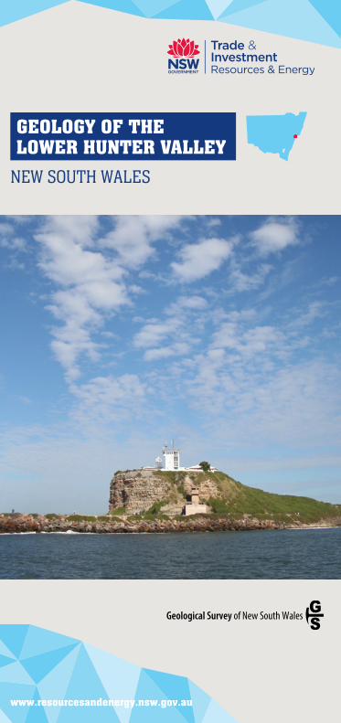
GEOLOGY OF THELOWER HUNTER VALLEY
NEW SOUTH WALES
www.resourcesandenergy.nsw.gov.au
Carboniferous volcanic and glacial rocks
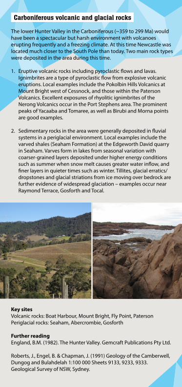
The lower Hunter Valley in the Carboniferous (~359 to 299 Ma) would have been a spectacular but harsh environment with volcanoes erupting frequently and a freezing climate. At this time Newcastle was located much closer to the South Pole than today. Two main rock types were deposited in the area during this time.
1. Eruptive volcanic rocks including pyroclastic flows and lavas. Ignimbrites are a type of pyroclastic flow from explosive volcanic eruptions. Local examples include the Pokolbin Hills Volcanics at Mount Bright west of Cessnock, and those within the Paterson Volcanics. Excellent exposures of rhyolitic ignimbrites of the Nerong Volcanics occur in the Port Stephens area. The prominent peaks of Yacaaba and Tomaree, as well as Birubi and Morna points are good examples.
2. Sedimentary rocks in the area were generally deposited in fluvial systems in a periglacial environment. Local examples include the varved shales (Seaham Formation) at the Edgeworth David quarry in Seaham. Varves form in lakes from seasonal variation with coarser-grained layers deposited under higher energy conditions such as summer when snow melt causes greater water inflow, and finer layers in quieter times such as winter. Tillites, glacial erratics/dropstones and glacial striations from ice moving over bedrock are further evidence of widespread glaciation – examples occur near Raymond Terrace, Gosforth and Tocal.
Key sitesVolcanic rocks: Boat Harbour, Mount Bright, Fly Point, PatersonPeriglacial rocks: Seaham, Abercrombie, Gosforth
Further readingEngland, B.M. (1982). The Hunter Valley. Gemcraft Publications Pty Ltd.
Roberts, J., Engel, B. & Chapman, J. (1991) Geology of the Camberwell, Dungog and Bulahdelah 1:100 000 Sheets 9133, 9233, 9333. Geological Survey of NSW, Sydney.
Early to middle Permian shallow marine fossils
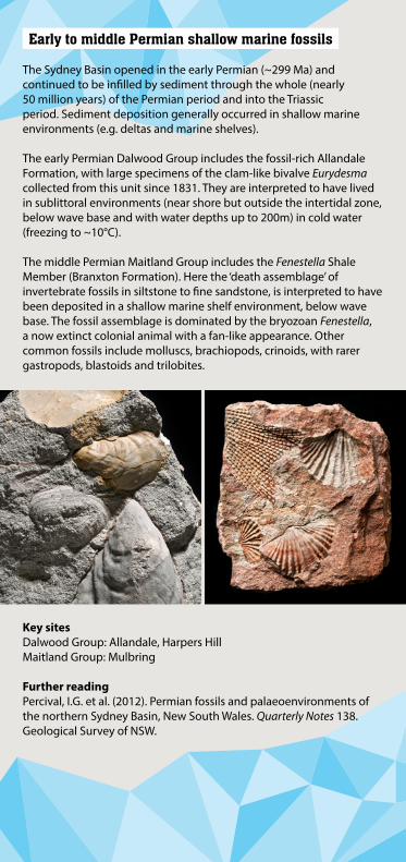
The Sydney Basin opened in the early Permian (~299 Ma) and continued to be infilled by sediment through the whole (nearly 50 million years) of the Permian period and into the Triassic period. Sediment deposition generally occurred in shallow marine environments (e.g. deltas and marine shelves).
The early Permian Dalwood Group includes the fossil-rich Allandale Formation, with large specimens of the clam-like bivalve Eurydesma collected from this unit since 1831. They are interpreted to have lived in sublittoral environments (near shore but outside the intertidal zone, below wave base and with water depths up to 200m) in cold water (freezing to ~10°C).
The middle Permian Maitland Group includes the Fenestella Shale Member (Branxton Formation). Here the ‘death assemblage’ of invertebrate fossils in siltstone to fine sandstone, is interpreted to have been deposited in a shallow marine shelf environment, below wave base. The fossil assemblage is dominated by the bryozoan Fenestella, a now extinct colonial animal with a fan-like appearance. Other common fossils include molluscs, brachiopods, crinoids, with rarer gastropods, blastoids and trilobites.
Key sitesDalwood Group: Allandale, Harpers HillMaitland Group: Mulbring
Further readingPercival, I.G. et al. (2012). Permian fossils and palaeoenvironments of the northern Sydney Basin, New South Wales. Quarterly Notes 138. Geological Survey of NSW.
Late Permian terrestrial fossils
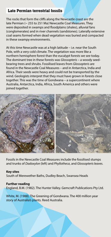
The rocks that form the cliffs along the Newcastle coast are the late Permian (~ 255 to 251 Ma) Newcastle Coal Measures. They were deposited in swamps and floodplains (shales), alluvial fans (conglomerates) and in river channels (sandstones). Laterally extensive coal seams formed when dead vegetation was buried and compacted in these swampy environments.
At this time Newcastle was at a high latitude – i.e. near the South Pole, with a very cold climate. The vegetation was more like a northern hemisphere forest than the eucalypt forests we see today. The dominant tree in these forests was Glossopteris – a woody seed-bearing trees and shrubs. Fossilised leaves from Glossopteris are found in the Newcastle Coal Measures – and in Antarctica, India and Africa. Their seeds were heavy and could not be transported by the wind. Geologists interpret that they must have grown in forests close together. This was the time of Gondwana – a supercontinent where Australia, Antarctica, India, Africa, South America and others were joined together.
Fossils in the Newcastle Coal Measures include the fossilised stumps and trunks of Dadoxylon (left) and Phyllotheca, and Glossopteris leaves.
Key sitesSouth of Merewether Baths, Dudley Beach, Swansea Heads
Further readingEngland, B.M. (1982). The Hunter Valley. Gemcraft Publications Pty Ltd.
White, M. (1988). The Greening of Gondwana. The 400 million year story of Australia’s plants. Reed Australia.
Quaternary floodplains and barrier systems
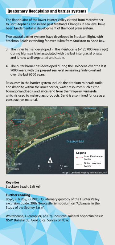
The floodplains of the lower Hunter Valley extend from Merewether to Port Stephens and inland past Maitland. Changes in sea level have been fundamental in development of the flood plain system.
Two coastal barrier systems have developed in Stockton Bight, with Stockton Beach extending for over 30km from Stockton to Anna Bay.
3. The inner barrier developed in the Pleistocene (~120 000 years ago) during high sea level associated with the last interglacial phase, and is now well vegetated and stable.
4. The outer barrier has developed during the Holocene over the last 9000 years, with the present sea level remaining fairly constant over the last 6500 years.
Resources in the barrier system include the titanium minerals rutile and ilmenite within the inner barrier, water resources such as the Tomago Sandbeds, and silica sand from the Tilligerry Peninsula which is used to make glass products. Sand is also mined for use as a construction material.
Key sitesStockton Beach, Salt Ash
Further readingBoyd, R. & Roy, P. (1995). Quaternary geology of the Hunter Valley: excursion guide. 29th Newcastle Symposium on “Advances in the Study of the Sydney Basin”.
Whitehouse, J. (compiler) (2007). Industrial mineral opportunities in NSW. Bulletin 33. Geological Survey of NSW.
Port Stephens
GrahamstownDam
TASMAN SEA
Stockton
Newcastle
S t o c k t o n B e a c h
0 5 10 km
LegendInner Pleistocenebarrier
Outer Holocenebarrier
Image © Land and Property Information 2014
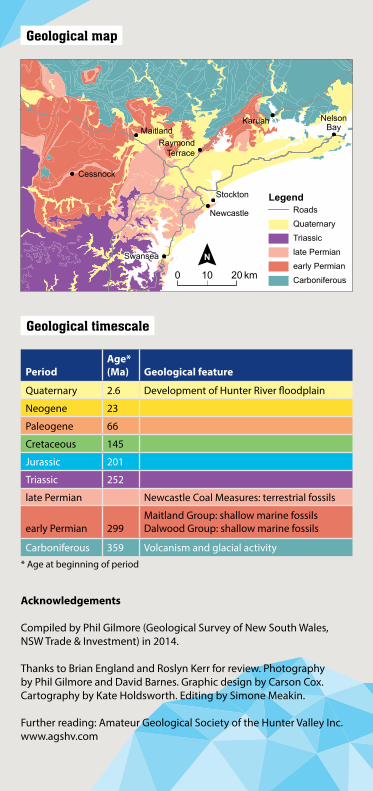
Geological map
Geological timescale
PeriodAge*(Ma) Geological feature
Quaternary 2.6 Development of Hunter River floodplain
Neogene 23
Paleogene 66
Cretaceous 145
Jurassic 201
Triassic 252
late Permian Newcastle Coal Measures: terrestrial fossils
early Permian 299Maitland Group: shallow marine fossilsDalwood Group: shallow marine fossils
Carboniferous 359 Volcanism and glacial activity* Age at beginning of period
Acknowledgements
Compiled by Phil Gilmore (Geological Survey of New South Wales, NSW Trade & Investment) in 2014.
Thanks to Brian England and Roslyn Kerr for review. Photography by Phil Gilmore and David Barnes. Graphic design by Carson Cox. Cartography by Kate Holdsworth. Editing by Simone Meakin.
Further reading: Amateur Geological Society of the Hunter Valley Inc. www.agshv.com
Karuah
RaymondTerrace
Newcastle
Swansea
NelsonBayMaitland
Stockton
Cessnock
LegendRoads
Quaternary
Triassic
late Permian
early Permian
Carboniferous0 10 20 km