Embed Size (px)
Citation preview

aEH
-Sfc&T
Geology of the Lead-Zinc Deposits in the Municipio de Januaria State of Minas Gerais Brazil
a
O5 H i i OQO PH W O
OS5
GEOLOGICAL SURVEY BULLETIN 1110-B
Prepared in cooperation with the Divisao de Fomento da Producao Mineral, Departamento Nacional da Producao Mineral, Minister to da Agricultura, under the sponsorship of the Agency for International Development, U.S. De partment of State


Geology of the Lead-Zincin
« /
State of Minas Gerais
By JACQUES F. ROBERTSpN
CONTRIBUTIONS TO BRAZILIAN GEQLQGY NQNFERROUS METALS
UG p, Q L 0 Q | C 4 L § I] R V g
P"fep@red in cooperation with the Qivis&Q d.e Foment® $a P<fQ(i,uc%Q Mineral,
T J N 1110-
MinMirk d® A under ike spmsor^hip of the Agtney f In$ern&ti@n@l Development,,partffient °J State
UNITED'STATES GOVERNMENT PRINTING OFFICE, WASHINGTON : 1963

UNITEP STATES DEPARTMENT OF THE INTERIOR
STEWART L. UDALL, Secretary
GEOLOGICAL 3URVEY
Thomas B. Nolan, Director
For sale by the Superintendent of Documents, U.S. Government Printing Office Washington, D.G. 20402

CONTENTS
Page Abstract_______________________________________________________ 35Introduction. _____________________________________________________ 37
Location of mineral deposits.___________________________________ 37Topographic features__.___-_-__.-_--_-._____._____.___._____ 40Geography and transportation routes.----_-_-___._____._________ 40Previous geologic work.________________________________________ 43Fieldwork and acknowledgments._-___---_-_-_---___________-___ 43
Geology._________________________________________________________ 45Stratigraphy._-___-.____._____..____-_-.__._______._____._____ 46
Bambuf series_---_---___..______----___-_--_-_-______-_--__ 47Historical conceptions of the Bambuf series_______-_-_-_ 47Section near Itacarambf ________________________________ 49Section on Morro Itapiracaba_-_--_--___-_-_______-_-___ 53Section at Alto de Palmeiras-_.._____-_--___-____________ 56Age of Bambuf series._________________________________ 57
Baurti formation. _________________________________________ 58Structure.. ___________________________________________________ 59
Folds-___--.___-_._-___-_______-_-_-_.--_-_-_-____--____. 60Faults and fractures..._-_-_.__.-..______.____._.___-_____._ 61
Physiographic development-____________________________________ 64Mineral deposits_________________________________________________ 68
Lithologic and structural control.._____________________________ 69Mineralogy________-__--___-___-___-_---_-_-_-_--___-_--___ 70Altered wallrock_______________________________________________ 74Classification and genesis._-__-_-___---------_--_________--____- 76Summary and conclusions____________________________________ 79
Description of deposits.____________________________________________ 84Mina Janelao______________________________________________ 84Mina Grande__..-_______-_-________--_--___-__-_-_____-_-__. 90Mina Sao Joao________________________________________________ 95Pimenteira, Jacarezinho, and Taquarf prospects__________--_--__ 97Riacho Se~co prospect--_________.___---_____-__________---_-__ 99Mina Fabiao_-__---_______-______-____-___--____-_____---__- 101Mina Capao do Porco__--__-_.___.-_____-__._______-__--_---_ 103Alto de Palmeiras prospect-_____-..____--__--________-_____-_-_-_ 104
References cited.___________________________________________________ 107Index________________________________________________________ 109

IV CONTENTS
ILLUSTRATIONS
[Plates are in pocket]
PLATE 3. Geologic map of area west of Itacarambf, Minas Gerais.4. Geologic map and section of Mina Grande.5. Geologic map of Mina Janelao. Page
FIGURE 4. Index map, showing location of the region of Januaria____ 385. Region of Janu&ria and Itacarambi, showing locations of
principal deposits.. _________________________-_------_ 396. Stratigraphic sections of parts of the Bambuf series near
Itacarambi___. ---_________________-_______--_----_ 507. Lapies surface of erosion developed on primary limestone and
dolomite breccia__--________-___-_________------__ 518. View of Morro Itapiragaba, showing contact between the
Bambuf series and overlying Bauru formation__________ 549. Geologic section from southeast side of Morro Itapirac.aba_-_ 55
10. Escarpment along Riacho Palmeirinha exposing the flat-lyingclastic rocks and limestone of the Bambuf series..------.- 56
11. Slumped and rotated blocks of limestone at base of scarp,Chico Pacheco road___-.-_._--__-_.-___._____-__-___ 60
12. View of one of the highly silicified and leached limestonemasses at Mina Sao Joao____-___--____________________ 75
13. Cliff along Riacho Embauba of limestone topped by dolomite,showing effects of solution weathering__-____-_____-.._ 85
14. View of Estaca Quatro zone at Mina Janelao, looking south. _ 8615. Sketch of Estaca Onze, Mina Janelao, showing the results of
geochemical prospecting._________...__._.__.____._.___ 8916. Highly silicified rib of limestone with discernible bedding in
center of mineralized zone, Mina Grande________________ 9217. Looking east along fracture at south edge of Mina Grande
mineralized zone___-___--__--__________.___--__-___ 9218. Geologic sketch map of Sao Joao mine and Pimenteira
prospect__ _ --------------__-_-___-_---__---_..__--_- 9619. Geologic sketch map of the Riacho S6co occurrence...-_____ 10020. Geologic sketch map of Mina Fabiao___________________ 10221. Geologic sketch map of the Alto de Palmeiras.------------- 105

CONTRIBUTIONS TO BRAZILIAN GEOLOGY NONFERROUS METALS
GEOLOGY OF THE LEAD-ZINC DEPOSITS IN THEMUNICIPIO DE JANUARIA,
STATE OF MINAS GERAIS, BRAZIL
By JACQUES F. ROBERTSON
ABSTRACT
Lead-zinc mines and prospects in the Municipio de Januaria, in. northern Minas Gerais, Brazil, are scattered along both sides of the Eio SSo Francisco for more than 100 kilometers. Seven deposits of lead and zinc and one fluorite prospect are grouped in a small area from 10 to 15 kilometers west of the village of Itacarambi. Others lie in a wide area surrounding the city of Januaria, of which only two small occurrences are described in this report,
Production of lead from these deposits has been small and discontinuous, to taling only a few tons of lead and several hundred kilograms of silver. In 1957, the surface zone of residual blocks of oxide ore at Mina Janeiro, west of Ita carambi, was explored; several thousands tons of hand-sorted ore was stockpiled and a few hundred tons was shipped to Bio de Janeiro for pilot-plant extraction of zinc. In the same year, a fluoride deposit near Mina JanelSo was explored. Reserves of the deposits west of Itacarambi are judged to be small on the basis of surface showings; those of deposits near Janudria are considered to be of no commercial importance.
Sedimentary rocks in the Januaria region include the Bambui series and the Bauru formation. The Bambui series consists of flat-lying carbonate and fine grained clastic rocks of possible Ordovi'cian or Silarian age. The base of the series is not exposed. A section of part of the Bambui series west of Itacarambi is 520 meters thick. The lower half includes six limestone and dolomite units of various types; the upper half is composed mainly of calcareous siltstone, and mudstone. West of the city of Januaria, the Bambui series consists of sub stantially the same units but the section is only 104 meters thick. The Bam bui series east of the Rio Sao Francisco in the section at Alto de Palmeiras is 210 meters thick and copsists mainly of calcareous mudstone and siltstone, with some interbedded. dark-gray limestone.
The Bauru formation of Cretaceous age overlies the Bambui series. It is con tinental in origin and consists of massive, fine-grained red-bed sandstone and small amounts, of siltstone containing variable proportions of calcareous, si liceous, and limonitic cement. The Bauni formation characteristically caps buttes and mesas; near the city of Januaria it is 90 ineters thick.
M.ost strata of the Janu&ria region are only slightly warped or faulted. West of Itacarambi, a broad anticline that is 6 tP 8 kilometers in length, trends N,
35

36
40° W. Drag folds, longitudinal and cross faults of small displacement, and monoclinal flexures occur along the limbs of this fold. Northeast and west of the structure the strata are virtually flat lying. A low dome is defined at the south east end of the anticline. Northwestward, the anticline dies out and the beds flatten. The Baurti formation is thought to have been involved in the deforma tion, but the evidence is inconclusive.
The mineral deposits in the Municfpo de Januaria contain the common primary and secondary lead-zinc minerals and occur as replacements and as vein fillings in fractures and faults; at a few places there are mantolike masses of silicified primary- or pseudo-breccia within, flat to gently dipping carbon ate rock. Most deposits west of the Rio Sao Francisco occur in a dark-weather ing crystalline dolomitic limestone unit of the Bambul series. West of Itacar- ambf they are related to the northeast-striking cross faults or to the northwest- trending faults and fractures that flank the anticlinal block. The location of these deposits seems to have been controlled by a combination of structure and lithology; clastic beds have not been favorable to the deposition of lead and zinc minerals.
All deposits are similar mineralogically. Primary sulfide minerals include argentiferous galena, sphalerite, and traces of chalcopyrite and bornite. The sulfide minerals were transported by solutions that silicified and dolomitized the country rock. Gangue minerals include quartz, calcite, barite, and fluorite; fluorite is sufficiently concentrated in lenses at one place to form a small minable deposit. Supergene alteration produced secondary lead and zinc minerals in cluding anglesite, cerrusite, smithsonite, and willemite. Other secondary min erals include minor amounts of descloizite and vanadinite, as well as traces of chalcocite and malachite. Oxidation has appreciably concentrated and up graded the lead and zinc content of some deposits.
The fissure veins range from 30 to 200 meters in length. Most are about 0.5 meter wide and are poorly mineralized; one fracture zone 180 meters long averages 10 meters in width and contains small, scattered, mineralized lenses and disseminations of lead-zinc minerals. The richest deposit, Janelao, con sists of residual blocks containing a mixture of primary and secondary lead and zinc minerals in colluvium. A vein possibly exists below this zone. A nearby solution channel was filled with the mineralized rubble derived from a vein or lens that existed above the present topography. Two pseudobreccia beds at Mina Grande and Mina Sao Joao range from 0.5 to 5 meters or more in thickness and cover 10,000 square meters of area. They contain scattered small lenses of mixed sulfide and oxidized lead-zinc minerals.
The deposits are classified as hydrothermal in origin, probably mesothermal to epithermal. The source of the ore and gangue minerals is unknown. , The deposits have been prospected and mined from shallow trenches and pits. .If drilling or tunneling in the deposits develops greater tonnage than is indicated by surface showings, 2 or 3 deposits might conceivably sustain modest ODGFa- tions. The rest are only showings that might provide a few tons of ore.Prospecting in the Januaria region should be directed primarily toward tectonicfeatures within limestone units of the Bambul series. The dark-weathering dolomite unit is a favorable host rock, particularly where faulted and also near itscontact with underlying limestone. Lower limestone units exposed in the area seem to be poor host rocks, but may be more favorable in other parts of the Sao Francisco valley. Indicators of possible ore deposits are silicified, bleached, and red to buff dolomite, and mantolike masses of siliceous pseudobreccia.

LEAD-ZINC DEPOSITS IN THE MUNICIPIO DE JANUARIA
Small deposits of lead and zinc are scattered along the Northward flowing Rio Sao Francisco in the Municipio de Januaria, in the north ern part of the States of Minas Gerais, Brazil. (See index map, fig. 4.) Growing demands by industry for lead and zinc in Brazil has made desirable a geologic study of these deposits and an appraisal of their potential value. Investigation of the Januaria region was started in June 1957 as part of the nonferrous mineral deposits pro gram of the U.S. Geological Survey in cooperation with its Brazilian counterpart, the Departamento Nacional da Produgao Mineral, Ministerio da Agricultura. The survey was sponsored by the Agency for International Development of the United States Department of State.
Past production of lead and zinc from the properties in the Muni cipio de Januaria has been small. Both primary and secondary ore minerals are found at the surface in fairly high concentrations, but their distribution is spotty and irregular. The deposits are associated principally with fracture veins and zones that are narrow and short; there is relatively little replacement of limestone beds. Little under ground exploration has been accomplished by which reserves of ore can be inferred and no information is available to estimate the character, depth, and amount of oxidation or secondary enrichment. Future production from this district will be short lived unless addi tional reserves are found.
On the basis of current knowledge, sustained production. of lead and zinc from combined primary and secondary ores might be success ful in the Itacarambi area for a few years, if all known properties are exploited jointly, operations are economical and kept on a small scale, and if capital investment is restricted to a minimum. Deposits should be explored before mining is attempted to determine whether adequate reserves of the desired ores exist. The Januaria area is remote from the nation's industrial plants and transportation costs of Ore or con centrates, therefore, will be relatively high,
LOCATION OF MINEBAL DEPOSITS
The more important deposits in the Municipio de Januaria are grouped within a few kilometers of each other, and are 10 to 15 kilo meters west of Itacarambi, in the dissected margin of the plateau that lies above the valley of the Kio Sao Francisco. (See fig. 5.) Capao do Porco, a small deposit of lead and zinc minerals that has been mined for silver, is in the Serra de Cantinho, 35 kilometers to the southwest of the river port of Januaria. A minor showing of lead and zinc on the Fazenda Palmeiras is located 30 kilometers southeast

38 TO IRA21MAM G
24°
36°
0 100 200 300 KILOMETERS
4 ii-Jlndex ffiap, shoWl&g location of the region of Jatiudrlk.

LEAD-ZINC DEPOSITS IN THE MUNICIPIO DE JANUARIA 39
FIGURE 5. Region of Janudria and Itacarambf, showing locations of principal deposits.

40 CONTRIBUTIONS TO BRAZILIAN GEOLOGY
of Januaria. Another deposit occurs 50 kilometers or so south of Januaria near the small knvn of Lontra, and another has been reported (Moraes, 1958, p. 149) from Brejo do Amparo, 5 kilometers northwest of Januaria. All of these are referred to as the Januaria deposits.
TOPOGRAPHIC FEATURES
The Rio Sao Francisco flows north-northeast in a trenchlike valley carved out of the great central peneplain of Brazil. The valley ranges from 20 to 30 kilometers in width, has a relatively flat alluvial floor, and is bordered by steep erosional escarpments at least 200 meters high. The escarpments are developed in virtually flat-lying limestone and clastic sediments of the Bambui series. The few peren nial tributary streams that interrupt the escarpments at wide in tervals have valleys that are relatively deep as compared to their widths. Normally, the Rio Sao Francisco is about 0.5 kilometer wide, but the swath cut by its flood plain averages 6 kilometers. Well- defined but somewhat dissected terraces, the tops of which stand 10 meters or more above the flood-plain level and which slope gently toward the river from the escarpments, border the flood plain on either side. The plateau west of the river has an altitude of about 700 meters and a relief of more than 250 meters.
The level of the river fluctuates as much as 16 meters between the normal high and low stages; its gradient is about 15 meters in 100 kilometers.
GEOGRAPHY AND TRANSPORTATION ROUTES
Januaria, a city of about 8,000 inhabitants, is the seat of the govern ment of the municipio, a political unit corresponding in function to a county. The city lies on the west bank of the Rio Sao Francisco at an altitude of 451 meters and is the main trade and transportation center for the region. It is a port for river traffic, the terminus of regular truck and bus transport, and a scheduled stop for an airline. Most commerce is handled by the steamships and launches that ply the river from the railhead and rapids at Pirapora, Minas Gerais, 468 kilometers scmth and upstream from Januaria, to Juazeiro, Bahia, 1,052 kilometers north and downstream from Januaria. The Comis- sao do Vale de Sao Francisco, a government corporation, has the largest and fastest river boats and is the main operator on the river.A rail line that is part of the network of the Central do Brasil Rail-road (E. F. Central do Brasil) connects Pirapora with Belo Horizonte to the south, a distance of 432 kilometers. The northern river terminus of Juazeiro, Bahia is connected to the seaport at Salva dor to the southeast, a distance of 571 kilometers by the railroad
Viagao Ferrea Federal Leste Brasileiro.

LEAD-ZINC DEPOSITS IN THE MTJNICIPIO DE JANUARIA 41
Overland, Januaria is reached by a road 215 kilometers long from Montes Claros, Minas Gerais, a city also on the Central do Brasil Kail- road. The road from Montes Clarosto Januaria is unpaved, and much of it is in poor condition because of sand, water, and insufficient main tenance. The Central do Brasil Railroad leads south from Montes Claros, past the junction with the trunkline from Pirapora, to Rio de Janeiro, via Belo Horizonte. The railroad also extends north to Salvador in Bahia. R-ail distance from Montes Claros to Rio de Janeiro is about 1,000 kilometers and to Salvador is about 1,150 kilometers.
A barge ferry crosses the Rio-Sao Francisco at Pedras de Maria da Cruz, 12 kilometers south of Januaria. The area is served also by an airline from Rio de Janerio that makes stops at Januaria several times a week.
The town of Itacarambi with a population of several thousand is nearest to the largest group of deposits. Although it is built on the west bank of the river, it is not a port for river boats during most of the year. During intervals of high water, boats and steamers can ap proach the town; for the rest of the time, the nearest landing is at Rus- sinho, a point 4.5 kilometers south. Fabiao and Pindaiba, loosely defined and unorganized communities near Itacarambi (pi. 3; fig. 5), are typical settlements in the region. They consist of a slightly denser group of farm settlements, developed in the more fertile areas along perennial streams, and are near the more enterprising and prosperous f azendas or at important crossroads.
Mineral deposits in the Municipio de Januaria are not reached easily, owing to lack of roads or to poor maintenance. Some deposits includ ing Capao do Porco and Riacho Seco are accessible only by foot or on horseback. Most of the deposits near Itacarambi can be reached by roads suitable only for four-wheel drive vehicles and oxcarts; these roads ascend the limestone escarpment west from Pindaiba and north west from Fabiao. (See pi. 3.) The roads are rough and, in places, steep; they deteriorate extensively during the rainy season. Roads in the area become overgrown in a short time if not used continously or if not cleared periodically. Between Itacarambi and Januaria the main roads are no more than enlarged trails that traverse swamps, sandy flood plains, and silty river terraces. During the dry season from May to October the roads are choked with dust and filled with irregular ruts and holes produced during the wet season. Travel by jeep or truck from Januaria to Itacarambi, a distance of 52 kilometers, takes 3 hours or more because of these conditions. The same roads are impass able during most of the rainy season, from October to April, because of mudholes and high water. Mining activity and commerce in gen eral are curtailed during these months.

42 CONTRIBUTIONS TO BRAZILIAN GEOLOGY
Only two seasons are recognized in the Januaria region, the rainy season from October to April during which virtually all the total annual rainfall of about 1,000 mm (Serebrenick, 1953) occurs, and the dry season from May to October when near-critical arid conditions develop. Temperatures the year round are moderate; the mean annual temperature is 24°C (75°F), and the average maximum daily tempera ture is 31°C (88°F). Karely does the temperature reach the maximum for the Januaria region of 40°C or the minimum of 6°C. The daily variation in temperature is about 13 °C.
Vegetation in the Municipio de Januaria varies from place to place, in accordance with drainage characteristics and soil. Because of the extensive karst topography in the limestone and dolomite areas, much of the drainage is underground in the plateau region. The disappear ance of surface drainage serves to aggravate conditions of aridity during the dry season. Nearly desert conditions that permit growth of only poor scrub brush (caatinga), cactus, and small hardy trees prevail on the plateau. Forests of large trees and dense underbrush (cerrados) flourish in the valleys and basins of the plateau, and along the escarpments where ground water keeps the soil moist. In many places not enough moisture exists at the surface to sustain small plants and bushes, but trees with deep roots grow well and produce parks that are relatively clear of brush and easy to traverse. On flood plains, vast areas are covered by loose sand that supports only sparse scrubby vegetation. Where the flood plain is swampy and dotted with oxbow lakes, rich silty soil supports dense, luxuriant forests; these are cleared for cultivation in places.
A plentiful supply of good timber for mining and construction pur poses is available in the forests. Hard and durable woods include cedro, a hard tropical wood similar to the North American cedar in resistance to insects and to general deterioration, and pan d'arco, ameira, and angico with similar properties. Many other woods of suitable quality for rough construction are available in the immediate areas of the mining properties.
Electric power is not yet available for mine use. Small diesel power- plants furnish Januaria and Itacarambi with electricity for municipal use. A hydroelectric plant of 5,000 kilowatts output to serve the region is being installed by the Comissao do Vale do Sao Francisco at the falls of the Rio Pandeiros, 40 kilometers west of Januaria.
The creeks of the upland area are filled with water during the wet season, but most creeks dry up soon after the rains stop. This presents a problem of-water supply at the mining properties for at least half the year. Small springs flow near Mina Janelao and Mina Grande, but these are not adequate to supply continuously the needs of mining
LEAD-ZINC DEPOSITS IN THE MUNICIPIO DE JANUARIA 43
camps. The Kio Peruagu, a river that issues from an underground course about 1 kilometer from Mina Janelao, is capable of providing adequate water for the mine. A mill for concentration of ores from the Itacarambi area would have to be located along the Peruagu or on the Rio Sao Francisco.
PREVIOUS GEOLOGIC WORK
Few geologists and mining engineers have published information on the deposits in the Municipio de Januaria. Barbosa and Oppenheim (1937) passed through Januaria in 1936, and recorded their impres sions of the stratigraphy. After M. Pimentel Godoy visited the region in 1940, Guimaraes, with the cooperation of Godoy, wrote a short paper (Guimaraes, 1948) in which he described the mineralogy of the deposits and discussed ore genesis in detail. Guimaraes did not include maps of the deposits or of the region. Gomes (1956) and Luciano Jacques de Moraes (1958), as well as Godoy (1958), have written review articles about the mines and minerals in the region. A few geologists of the mining companies have made reconnaissance examinations, but their findings are not available for publication.
FIELDWORK AND ACKNOWLEDGMENTS
In 1957, the Department© Nacional da Produgao Mineral and the U.S. Geological Survey agreed to study the deposits of the region of Januaria. A preliminary reconnaissance, made to determine the gen eral distribution and size of deposits, showed that only the deposits in the vicinity of Itacarambi are large enough to warrant commercial in terest. Field studies occupied a period of 31/2 months from June to October 1957. During this period, 10 deposits were examined; 4 were surveyed by planetable on a scale of 1: 2,000 and 4 were mapped by compass and tape at scales ranging from 1: 500 to 1:2,000. A tri- angulation control net was established with planetable and alidade along the Rio Sao Francisco from Morro Itacarambi southward for 11.5 kilometers, and westward to Mina Grande, a distance of 15 kilo meters. A base line and several points established by Cruzeiro do Sul, S.A. were used. A planimetric map of the Itacarambi area, on a scale of 1:25,000, was compiled from the triangulation net and aerial photographs.
In addition to the studies of the mineral deposits, the geology of the Januaria region was reconnoitered for features that might be signifi cant to the occurrence of mineral deposits. Several stratigraphic sec tions were measured, including a composite one in the vicinity of Ita carambi, one on Morro Itapiragaba near Januaria, and a third on the Fazenda Palmeiras. The region near Itacarambi was mapped on

44 CONTRIBUTIONS TO BRAZILIAN GEOLOGY
aerial photographs and the results were then transferred to a plani- metric base. About 40 square kilometers of area was covered on foot, and 180 square kilometers or more was mapped by photointerpretation after fieldwork was completed.
The bearings used by the author are based on an assumed magnetic declination of 17°30' west of north, the orientation of north-south grid- lines with meridians on maps of the Eio Sao Francisco surveyed by Companhia Cruzeiro do Sul. Isogonic lines on the Santa Maria Range chart (1140) of the World Aeronautical Chart series show a magnetic decimation of 15° west of north for this area. Altitudes were carried from elevation bench mark RN 393 located in Itacarambi by Companhia Cruzeiro do Sul. Altitudes at Mina Janelao are based on an assumed elevation of 600 meters at estaca 3 (stake 3).
The author is indebted to many people for assistance rendered in this study. Dr. Avelino I. de Oliveira, Director of the Departmento Nacional da Produgao Mineral, and Mr. John Van N. Dorr II of the U.S. Geological Survey were largely responsible for establishing the cooperative base-metal studies program in Brazil. Engenheiro Ger- aldo C. Melcher of the Departmento Nacional da Produgao Mineral helped to formulate the program and gave impetus .to the study of the Januaria district. Mr. Emerson I. Brown, Minerals Attache of the United States Embassy in Rio de Janeiro, provided useful information and encouragement in beginning the investigation. After June 1957, the studies were under the supervision of A. J. Bodenlos, U.S. Geolog ical Survey. The work was sponsored by the Agency for International Development of the U.S. Department of State.
The author was ably assisted, in the field and office, by Engenheiro Clovis C. Carraro of the Departamento Nacional da Prodtkgao Mineral, who acted as interpreter and translator, helped greatly in assembling and maintaining equipment, performed many surveying operations, and was mainly responsible for the redrafting of maps and sketches. Srs. Lauro Morandi and Miran de Barros Latif of Sao Paulo were most generous in providing quarters at the company camp while the investigations were being made at Mina Janelao. They gave valuable assistance also in the surveying of properties in the Itacarambi area. Special thanks are due their associate, Engenheiro Prospero C. Pao- liello, who acted as guide for 2 weeks in the preliminary reconnais sance of the region, arranged important introductions to inhabitants of the area, and passed along much useful information about the dis trict. The investigations were greatly facilitated by Sr. Joao Ferreira de Souza, who opened his home at Fazenda Bela Vista to the author as a base of operations in the Itacarambi area, and also by Mr. L. C. Scofield, who extended the same courtesy in Januaria. Many other

LEAD-ZINC DEPOSITS IN THE MUNICIPIO DE JANTJARIA 45
local inhabitants in the Municipio de Januaria gave much assistance during the field study.
Various officials of the Departamento Nacional da Produgao Mineral gave valuable technical assistance. Quimico Luiz Ignacio Miranda, Director of the Laboratorio da Produgao Mineral, arranged for anal yses of mineralized rock; Engenheiro Elysiario Tavora Filho, Director of Laboratorio de Mineralogia e Cristalografia, of the Segao de Petro- grafia, made mineral identifications by means of X-ray spectrography; and Sr. F. W. Sommer from the Segao de Paleontologia studied sphe rules that were thought to be fossils from limestone of the Bambui series.
GEOLOGY
The rocks in the Municipio de Januaria are flat-lying marine sedi mentary rocks overlain by terrestial sandstone. On the west side of the Rio Sao Francisco, a sequence of limestone and dolomite overlain by argillaceous rocks is assigned to the Bambui series of probable early Paleozoic age. On the east side of the river, the Bambui series con sists of argillaceous rocks in the lower part of the section, limestone in the middle, and interbedded limestone and argillaceous rocks at the top. A continental red sandstone, correlated with the Bauru forma tion of Late Cretaceous age, rests with apparent unconformity on the sedimentary rocks of the Bambui series. Metamorphism has been very slight in the area being described; it is evident only in recrystalli- zation of some beds of calcarous rocks, in the weak development of quartzite, and in the incipient development of sericite in the clastic rocks. Igneous rocks were not seen during the fieldwork on this proj ect, but an aerial magnetometer survey by LASA1 disclosed a strong anomaly 6 kilometers southwest of Januaria. A field check disclosed an outcrop of igneous rock that appeared to be quartz diorite (E. P. Scorza, petrologist, Departamento Nacional da Produgao Mineral, oral communication).
The strata throughout most of the region show little evidence of disturbance, appearing to be virtually horizontal. West of Itaca- rambi, however, they are warped into a broad anticline that plunges gently northwestward and is flanked by monoclinal flexures and other minor folds. (See pi. 3.) The monoclinal flexures are partly"trans-
1 Shortly after the author's project was started, the Departamento Nacional da Producao Mineral contracted with Levantamento Aerofotogrametricos, S.A. (LASA) to investigate an area in the Rio Sfto Francisco basin, somewhat more extensive than that covered by the author, but with similar emphasis on the mineralized areas including Itacarambf and Januaria. The LASA project Included an aerial magnetometer survey and was designed to determine the relationships of magnetic anomalies and geologic structure to the location of the mineral deposits. The resulting maps had not been completed at the time this manuscript was written.

46 CONTRIBUTIONS TO BRAZILIAN GEOLOGY
lated along--strike into faults with small displacement. Some cross faults of slightly younger age also are found.
Three landf orms are seen in the region of Januaria. The principal one is a result of differential erosion of flat-lying rocks that underlie the extensive plateau of central Minas Gerais, exemplified by table lands, by mesas and buttes, and by the steep, impressive escarpments along the Rio Sao Francisco. The second is represented by karst features, including sinkholes of many kinds and in every state of evolution, disrupted drainage patterns, and extensive areas of rough, serrated, and grooved erosion surfaces (lapies), all produced by solu tion. The third is related to river channels and flood plains and includes terraces, channel bars, and natural levees. The flood plain also contains numerous lakes and swamps, formed in abandoned parts of the channel. Tributary streams traversing the Rio Sao Francisco flood plain commonly meander and in places are strikingly braided.
STRATIGRAPHY
Sedimentary rocks in the Januaria region are limestone, dolomite, and fine-grained argillaceous rocks assigned to the Bambui series, overlain unconformably by massive fine-grained sandstone and silt- stone of continental origin, believed to be part of the Bauru forma tion. The Bambui series is widely exposed in the bluffs along the Rio Sao Francisco, and is tentatively dated as of early Paleozoic age, al though diagnostic fossils have not been found in the series. The non- marine strata are correlated on the basis of lithologic similarity with the Bauru formation of the northern part of the State of Sao Paulo and the southwestern part of the State of Minas Gerais, where the unit contains vertebrate fossils of Cretaceous age.
The sedimentary rocks exposed in the bluffs west of the Rio Sao Francisco are about 600 meters thick, of which about 500 meters is in the Bambui series and the remainder is included in the Bauru forma tion. Most of the lower half of the Bambui series is dark-gray lime stone containing some dolomite; most of the upper half is siltstone and mudstone. Although containing lithologically similar beds, stratigraphic units of the Bambui series east of the Rio Sao Francisco cannot be correlated with units west of the river. Relationships areobscured by 6 kilometers of alluvium-floored valley between outcrops.
Stratigraphic sections of the Bambui series and Bauru formationwere measured and studied at three separate localities. One is westof Itacarambi, the second is several kilometers southwest of Januariaon Morro Itapiragaba, and the third is at Alto de Palmeiras, 30 kilo meters southeast of Januaria and east of the Rio Sao Francisco. Al though time did not permit a comprehensive study of the regional

LEAD-ZINC DEPOSITS IN THE MUNICIPIO DE JANUARIA 47
stratigraphy, impressions gained of the character and distribution of sedimentary rocks in the Januaria region are presented below.
BAMBUI SERIES
The oldest rocks exposed in the Januaria region belong to the wide spread Bambui series of early Paleozoic age. The distribution of the Bambui series is fairly well known throughout the drainage basin of the Kio Sao Francisco. Outcrops of the series extend from the Serra das Vertentes and the area of Sete Lagoas, Minas Gerais in the south to the curve of the Eio Sao Francisco in the northern part of the State of Bahia, and from the Serra de Espinhago on the east to the boundary between the States of Goias and Minas Gerais on the west.
HISTORICAL CONCEPTIONS OF THE BAMBUI SERIES
Much has been written about the general character, distribution, and age of the Bambui series. The rocks of the series were first de scribed by Liais (1872, p. 147-148). Derby (1879, p. 98-104 and 1882, p. 24-26) described the rocks along the Eio Sao Francisco and the Rio das Velhas in considerable detail. Although credited with first using the name Sao Francisco series (Oliveira and Leonardos, 1943, p. 260), Derby referred to the sequence only as a group of rocks characteristic of, and widespread in, the basin of the Rio Sao Francisco. Obviously, he considered his reconnaissance studies insufficient for naming the rock units. Later, Rimann (1917, p. 30) applied the name Bambui to the series, and through popular usage since then, Bambui has become firmly established in the literature. Freyberg (1932, p. 119-158) studied the series in central Minas Gerais, and others, including Bar- bosa and Oppenheim (1937), Guimaraes (1948), and Gomes (1956) have described these strata in the Januaria region.
In his reconnaissance, Derby (1882) obtained the impression that the series is divisible lithologically into three parts. He described the lower part as predominantly dark, hard, thinly laminated silt- stone and fine-grained sandstone; the middle part as mainly black argillaceous "schist"; 2 and the upper part as predominantly bluish, compact calcareous rocks. Each of the rock types, however, occurs abundantly in each of the other main divisions. Throughout the section, several thousands of meters thick, the shaly beds quantita tively far surpass the limestone and siltstone. The predominance of limestone in the Januaria area would seem to place those rocks in the upper part of the series as divided by Derby.
In a later paper, Derby (1906, p. 395) suggested the possibility that the limestone of the upper Rio Sao Francisco might be separated
2 Older reports in Portuguese use only one word for fine-grained clastic rocks, "xlsto," which can be Interpreted as schist, slate, or ahale.
676-419 O 63 2

48 CONTRIBUTIONS TO BRAZILIAN GEOLOGY
into two distinct groups, an older one to include the more disturbed, fine-grained sandstones and shales of "almost certain early Paleozoic" age, and a younger group of predominantly horizontal beds. These reflections, however, appear to be speculative, for nowhere does he state that he actually saw a horizontal series of beds of this descrip tion lying unconformably on folded, disturbed beds. Notwithstand ing, the virtually horizontal calcareous beds in the Municipio de Januaria would belong in Derby's younger group.
Freyberg, working in the southern part of the Rio Sao Francisco basin, divided the Bambui series into eastern and western facies. He calls beds mostly east of the upper Rio Sao Francisco, "Camadas Gerais" 3 (Freyberg, 1932, p. 122). Rocks of only slightly different character that crop out west and southwest of the upper reaches of the Rio Sao Francisco to the Triangulo Mineiro of western Minas Gerais are referred to as "camadas Indaia." The "camadas Indaia" are said to contain more argillaceous and less quartzitic rock than the "camadas Gerais." He further states that the "camadas Gerais" are generally flat lying. This observation seems to be part of his defini tion of facies, but this is a curious extension of the meaning. More- over, some of the area presumably underlain by undisturbed "camadas Gerais" in the valley of the Rio das Velhas, was described by Derby (1882, p. 25) as being underlain by deformed rocks. Nowhere was Freyberg able to see a contact or lithologic gradation between the two facies, and so was not able to ascertain the true stratigraphic relation ship between the two "camadas."
In the Januaria region, the beds are generally horizontal and so they presumably should be correlated with the "camadas Gerais." The criteria used by Freyberg to separate the two facies, however, is dubious, and cannot be reliably applied here, as a great distance separates the Januaria region from the localities Freyberg studied. Nor can Derby's suggestions be applied with certainty because the character of the Bambui series as exposed is different from the descrip tions of these rocks to the south. The problem of whether the Bambui series should be divided into an older and younger group based on relative amount of deformation as Derby suggested, or into two litho- logic groups or camadas based on the facies concept propounded by Freyberg, awaits a great deal more detailed mapping and strati- graphic study in the ba§jn of the Rio Sao Francisco.
8 The word "camadas" is translated as layers or strata of rock.

LEAD-ZINC DEPOSITS IN THE MUNICIPIO DE JANTJARIA 49
SECTION NEAK ITACARAMBI
The Bambul section near Itacarambi is representative of the series west of the Rio Sao Francisco in the Municipio de Januaria. A stratigraphic section of a part of the Bambui series was measured in the lower part of the escarpment north of the Chico Pacheco road (loc. A, pi. 3). The upward continuation of the stratigraphic section was studied 10 kilometers to the north on the .trail to prospect Jacarezinho (loc. B); a general correlation between the two is shown in figure 6. The carbonate rocks of the section are described by units.
Description of stratigraphic sections of parts of the Bambui seriesnear Itacarambi
[Section A, scarp north of Chico Pacheco road. Section B, on trail to Jacarezinho]
Meters6. Limestone, light-gray, fine-grained, laminated; minor dolomite
breccia interbedded____________ _ ________________ 5+5. Limestone and dolomite, light-gray to pink and buff, saccaroidal
massive, black-weathering; minor silica and chert along bedding planes _ _ _ _ _ _ _-_ ___ _-_ 53
4. Limestone, medium to dark-gray, fine-grained, thick-bedded tomassive; crossbedded at top__ _ _________ __ 35
3A. Limestone, medium gray at base, fine-grained and laminated; inter- bedded dolomite breccia; primary limestone and dolomite breccia above _____ ________ _ _______ _____ 25+
3B. Limestone and dolomite, primary breccia, interbedded with medium- gray, laminated limestone. Equivalent to 3A at locality B.
2. Limestone, medium dark-gray, thick-bedded (mainly more than 20 cm thick, fine-grained; mottled with redeposited calcite along bedding planes; minor interbedded dolomite breccia in section B____ __ 56
1. Limestone, medium dark-gray, fine-grained, thin-bedded (less than20 cm thick) ; base not exposed __ 30-f
Total _________________________________ 204+
Unit 1: The lowermost unit consists of at least 30 meters of a thin-bedded limestone cropping out at the base of the escarpment at locality A. On fresh exposure this limestone is dark gray, fine grained, and crystalline; it weathers medium light gray. Most of the individual beds are actually lenses, only a few of which exceed 20 centimeters in thickness and which thin out laterally within short distances.
Unit 2: Overlying the thin-bedded limestone is thicker bedded but otherwise nearly identical limestone with beds commonly more than 20 centimeters thick. Many beds have a mottled appearance pro duced by clots of recrystallized, buff to pink calcite along bedding

50 CONTRIBUTIONS TO BRAZILIAN GEOLOGY
SECTION
100 200 300 400 METERS
FIGURE 6. Stratlgraphlc sections of parts of the Bambuf series near Itacarambf.
planes. The unit also contains a few thin lenses of dark-gray chert. At one or two places, tiny spherules of silica were found, but they are not considered to be of organic origin (F. W. Sommer, DNPM, written communication, May 1958). At locality B a few beds of dolomite intraformational breccia are interbedded with the limestone near the top of the unit. The thickness of unit 2 at locality A is about 56 meters; its thickness was not measured at locality B.
Unit 3: Primary breccia of limestone and dolomite, some of it un doubtedly intraformational, occurs above the thick-bedded limestone. This breccia contains lenses of fine- to coarse-grained, thinly lami nated, light-gray limestone and dolomite, interbedded and grading in and out laterally with it; some laminae range from greenish to pinkish gray. The laminated limestone predominates near the base of the unit, but higher in the unit it occurs sparsely. The primary breccia consists of unsorted angular platy fragments of light-gray, fine-grained, laminated limestone and dolomite in a fine- to coarse grained groundmass of clastic carbonates. In places, the angular platy fragments have been rotated only slightly from their original positions in the bedding planes; at other places disturbance appears to have been great, with turbulent mixing of fragments. Locally, a few thin layers are contorted, but their deformation is confined within a small part of this stratigraphic unit. Calcite crystals more than a centimeter long are abundant in the breccia and laminated
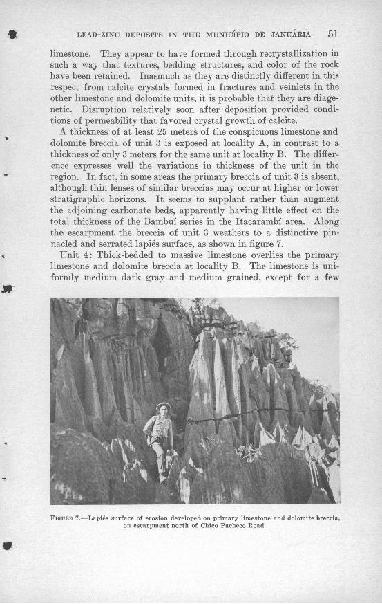
LEAD-ZINC DEPOSITS IN THE MUNICIPIO DE JANUARIA 51
limestone. They appear to have formed through recrystallization in such a way that textures, bedding structures, and color of the rock have been retained. Inasmuch as they are distinctly different in this respect from calcite crystals formed in fractures and veinlets in the other limestone and dolomite units, it is probable that they are diage- netic. Disruption relatively soon after deposition provided condi tions of permeability that favored crystal growth of calcite.
A thickness of at least 25 meters of the conspicuous limestone and dolomite breccia of unit 3 is exposed at locality A, in contrast to a thickness of only 3 meters for the same unit at locality B. The differ ence expresses well the variations in thickness of the unit in the region. In fact, in some areas the primary breccia of unit 3 is absent, although thin lenses of similar breccias may occur at higher or lower stratigraphic horizons. It seems to supplant rather than augment the adjoining carbonate beds, apparently having little effect on the total thickness of the Bambui series in the Itacarambi area. Along the escarpment the breccia of unit 3 weathers to a distinctive pin nacled and serrated lapies surface, as shown in figure 7.
Unit 4: Thick-bedded to massive limestone overlies the primary limestone and dolomite breccia at locality B. The limestone is uni formly medium dark gray and medium grained, except for a few
FIGURE 7. :Lapies surface of erosion developed on primary limestone and dolomite breccia, on escarpment north of Chico Pacheco Road.

52 CONTRIBUTIONS TO BRAZILIAN GEOLOGY
thin interlayered beds of laminated limestone and medium-grained, light-gray to buff dolomitic limestone that weathers dark gray. The top 8 meters-of this unit is crossbedded. Unit 4 is about 35 meters thick at locality B.
Unit 5: The thick-bedded to massive limestone in unit 4 is over lain by massive limestone and dolomite that weathers from dark gray to nearly black. The weathered color contrasts with the lighter gray of the limestone units stratigraphically above and below, and thus permits ready identification of the unit, especially in escarp ments bordering the river. On fresh exposure the carbonate rock in unit 5 is medium grained and saccaroidal and ranges from rose or buff to light gray and white. It has the appearance of a recrystal- lized altered rock, as bedding planes are generally obscure and irregu lar, or absent. In places, unit 5 consists of recemented breccia of large blocks and small fragments. Although some of the breccia is of primary origin, at several localities it is recognized as a collapse breccia formed during erosion. Many irregular silica masses may be seen along fractures and bedding planes. This distinctive unit is found in the vicinity of all the known mineral deposits near Itaca- rambi. At locality B, unit 5 is 53 meters thick.
Unit 6: The uppermost unit of the section at locality B consists of medium light-gray very fine grained laminated limestone, similar to the laminated limestone of unit 3. Interbedded with this unit are thin layers of limestone or dolomite breccia. Only the basal 5 meters of the unit remains at locality B.
This unit is more completely exposed along the tributaries of the Riacho Embauba east of Mina Janelao where it overlies the black dolomitic limestone of unit 5. In that area, the strata comprising unit 6 are about 90 meters thick and consist of thin-bedded medium- to dark-gray fine-grained limestone, several beds of which are dolomitic, argillic, or siliceous. The unit also contains a few beds of chert and calcareous shale and one bed, about half a meter thick, of limestone pebble conglomerate.
Clastic rocks above unit 6: Conformably overlying the limestone and dolomite in the plateau region west of Itacarambi are beds of calcareous siltstone, mudstone, and shale; a few thin beds of chert, limestone, and possibly fine-grained tuff are interlayered with them. The beds of fine clastic sedimentary rocks total more than 250 meters in thickness about 2 kilometers west-south west of Mina Grande. The
shales range from yellowish brown to greenish gray, and a few beds

LEAD-ZINC DEPOSITS IN THE MUNICIPIO DE JANUARIA 53
are red. Slightly lustrous bedding surfaces of some shaly rocks results from finely divided flakes of mica. Kocks of the unit are weakly indurated and crumble readily where weathered. They are capped at one or two places by quartzite of the Bauru formation.
The age of these clastic rocks is questionable. It is possible that they are much younger than the Bambui series and equivalent to one of the formations of Mesozoic age that are widespread in western Minas Gerais. The author prefers to include the fine-grained clastic rocks with the Bambui series, first, because the contact between these rocks and the limestone of unit 6 is gradational; second, because the clastic rocks are abundantly calcareous, in contrast to the noncalcare- ous continental clastic rocks of the overlying Bauru formation; and third, because comparable fine-grained clastic rocks are described as part of the Bambui series in other areas.
The total thickness of the Bambui series exposed in the vicinity of Itacarambi is about 520 meters, half of which consists of the clastic, fine-grained strata above unit 6.
SECTION OK MORRO ITAPIRAQABA
The Bambui series crops out also on the southeast slope of Morro Itapiragaba near Januaria (fig. 8) where the sequence of limestone and dolomite is the same as in the vicinity of Itacarambi but the thick ness is much less. A comparison of the sections (fig. 9) follows: Unit 1 on Morro Itapiragaba is a medium- to dark-gray fine-grained thin-bedded limestone, but is only about 20 meters thick, instead of 30 meters as at Itacarambi. This unit is succeeded by 12 meters of thick-bedded limestone of unit 2 (with beds generally more than 20 centimeters thick), whereas in the Itacarambi section unit 2 is 56 meters thick. Above this limestone on the north side of the morro is about 8 meters of laminated, light-gray limestone of unit 3. The fact that this limestone is absent on the southeast side of the hill indicates that the formation is lenticular. Unit 4, of thick-bedded to massive limestone, is absent at Morro Itapiragaba. Next higher in the section is the distinctive black-weathering but light-gray sac- caroidal limestone and dolomite of unit 5. This unit has dolomite primary breccia interbedded with it. Only 24 meters of the "black" dolomite and limestone is found on Morro Itapiragaba, compared to 53 meters measured in the stratigraphic section near the Jacarezinho prospect.

54 CONTRIBUTIONS TO BRAZILIAN GEOLOGY
FIGURE 8. The flat-topped hill in the far distance is Morro Itapiragaba, seen from the northeast. The distinct break in its slope marks the contact between the Bambui series and overlying Bauru sandstone. Limestone is exposed in the hill to the right in the distance.
The section immediately above unit 5 includes 12 meters of lam inated limestone, overlain by 28 meters of dolomitic and argillaceous limestones and interbedded chert lenses. Litholrgically, this section is similar to the thin-bedded limestone above the "black" dolomite near Mina Janelao, but it is slightly less than half as thick. The dolomitic and argillaceous limestone is topped by calcareous shale with thin layers of interbedded dolomite and limestone. The con tact appears to be gradational and entirely conformable. Only about 8 meters of shale beds are exposed; the contact with the overlying red sandstone and quartzite of the Bauru formation is covered by soil and rubble. From topographic expression, however, it is sur mised that the shale member is thin in this locality, possibly 10, or at the most 20 meters thick. The total thickness of sedimentary beds of the Bambui series exposed on Morro Itapira§aba is only 114 meters as compared to 517 meters near Itacarambi.

LEAD-ZINC DEPOSITS IN THE MUNICIPIO DE JANUARIA 55
o
ra
</> iii.ii
(rIi l Q ro ^ c\J ^° f^J,_ <fl OO^^^CM mUl2:
. . o
: . . . u_^\- . '^\. .
^<vv ... UJ>i 'i
\- °
\'j "" °Vv I " "
/\u 1 - -^/ \l _ "
O 01 ' '-" .'. Q-I
* ~-L_ " ' "
O >- \ ' ~0 t ";. .. _ _ <2 L ' ' ""
/-v ce V 1 - -
BAURU FORMATION (Cretaceous Sandstone and Quartzite 90m
DISCONFO
BAMBU.I SERIES (early Paleozoic?) Limestone and dolomite ,,
104m, base not-'exposed ^^0=^^,
C \ \ i i Jiii iiS 1 1 1 1 1s i i j i ii
. , , i -r- , i ,'!'!' 1 '!'!'!'
c/), .- , , ,cs' ' ' '
IM'
oin <J
'D c
O c
2 "« 0C CC
? u!' M
1 f.5 8 1O " 'CO flJ o£ = *> ° w "o
o: * £ cf TJ' o 'i -^UJ * in "O "^ °. E S |o x o a) SOn *" c S'^ * P *-
o Js o>c c w
§ ^ i I00 .. w M
0) TJ NCO) 0) t
0 -s o * !S o gg- S t; 2 * % o-
E | s | 8 ^0 -g = 1 1 I 1O- TJ ~? T3 J= C 3 -1 -o « <P o o P0 _____
Medium to dark gray fine grained thin and thick be Black-weathering, light-gray, saccharoidal dolomite < Medium to light gray fine to coarse grained laminat
Dolomitic limestone, in part argillaceous
Argillaceous limestone and dolomite, interbedded, Calcareous shale, with dolomite breccia at base Contact between Bambui series and Bauru formati
Red to buff fine grained sandstone and quartzite, i
Contains few nodules and fragments of chert
< 03 o a uj u, oUJ O O O O °(_ O ID o IT)
s: "

56 CONTRIBUTIONS TO BRAZILIAN GEOLOGY
The section at Morro Itapiracaba is much thinner than the section measured near Itacarambi, although the rock units occur in the same order of deposition. A possible explanation for the consistent differ ence in thickness in the units between the two localities is a shoaling sea in the vicinity of Januaria during the period of deposition. Part of the great difference in thickness of the clastic sedimentary rocks at the top of the section may have resulted from differential subaerial erosion before deposition of the overlying Bauru formation.
SECTION AT ALTO DE PALMEIRAS
The third section in which the Bambui series was measured is near the prospect, Alto de Palmeiras, on the fazenda of Senhor Henrique Oliva Brasil, 30 kilometers southeast of Januaria. Although the rocks belong to the Bambui series, the section is different than that exposed west of the Rio Sao Francisco. At the base, beginning on the south side of the creek Riacho Palmeirinha (fig. 10), is about 35 meters of buff to light greenish-gray uniformly thinly laminated mud- stone, in part calcareous. This rock contains very fine grained sec ondary mica, and possibly chlorite. It crumbles readily and erodes to subdued hummocks and slopes. Overlying this basal unit is 55 meters of reddish-brown, silty mudstone, also thinly laminated and slightly calcareous in part; it is somewhat harder and forms steep
FIGURE 10. Escarpment on the south side of Riacho Palmeirinha, exposing flat-lying beds of the Bambui series. The contact between the clastic rocks and overlying limestone is at the base of the prominent cliff-former near the top.

LEAD-ZINC DEPOSITS IN THE MUNICIPIO DE JANUARIA 57
slopes. Above this unit are 15 meters of cliff-forming slaty mud- stone and siltstone that are reddish brown, greenish gray, and buff. Following is a unit at least 55 meters thick of thin-bedded dark-gray fine-grained limestone that weathers light gray and forms imposing cliffs. At the top of this section occur about 50 meters of cyclicly interbedded fine-grained limestone, calcareous shale, and ^mudstone, similar lithologically to the units occurring below in the section. Each cyclothem is several meters thick. The section exposed here totals roughly 210 meters.
The units in the section at Palmeiras do not correspond to those seen west of the Kio Sao Francisco. The clastic rocks in the lower part of the Palmeiras section, 105 meters thick, are uniform in com position compared to the upper part of the section at Itacarambi where chert, limestone, siltstone, and mudstone all are interbedded. The limestone in the middle of the Palmeiras section is similar to the limestone unit at the base of the Itacarambi and Morro Itapiragaba sections, but the cyclically interbedded unit above bears no resemblance to any beds west of the river.
Tracing the strata from one side of the river to the other in the Januaria region is hindered because the alluvium-covered flood plain separating outcrops is at least 8 kilometers wide. The difference in the sections could be attributed to facies changes in the series or to faults concealed by flood-plain deposits. It is also possible that an indiscernible regional dip exists in the region; even if as little as 2° in either direction, hundreds of meters difference in section could result.
AGE OF BAMBUI SERIES
Although considerable time and effort were spent in search of fossils in the Bambui series, none were found.
At two localities in the Itacarambi area tiny siliceous spherules resembling algae or spores and ranging from 1 to 10 mm in diameter were found along bedding planes of thin-bedded limestone near the base of the exposed stratigraphic section. One locality-is near the Chico Pacheco road in section A and the other is in a low knoll of limestone southwest of the community of Pindaiba. F. W. Sommer of the Laboratorio de Micropaleontologia da Divisao de Geologia e Mineralogia, Departamento Nacional da Produgao Mineral, examined the material and reported (written communication, May 1958) :
An assemblage of forms that, morphologically, produce small spheres (nodules) and configurations that remind one of algae or lichen with apparent centripetal growths. They do not belong, in spite of their form, to algal groups or other vegetable macro- or micro-fossils of my present acquaintance. I consider these configurations inorganic phenomena ludus naturae resulting from solution and redeposition (of silica).

58 CONTRIBUTIONS TO BRAZILIAN GEOLOGY
It can be speculated that they were epigenetically formed by secondary silica that penetrated along bedding planes in successive waves and was deposited concentrically about various nuclei.
The age of the Bambui series is open to question. Oliveira and Leonardos (1943, p. 259) cite Derby as having tentatively assigned an age between the Late Silurian and Permian. His fossils from Bom Jesus da Lapa, however, were admittedly poor and of doubtful value. Later, Ruedemann (1929, p. 46), on the basis of questionable Favosites coral fragments collected from the same area, gave the tenuous opinion that the age is Silurian for the upper part of the series, or "camadas Gerais" as implied by Oliveira and Leonardos (1943, p. 259). Oliveira and Leonardos conclude their discussion by saying that they have to admit, for the lower series (or "camadas Indaia"), an Early Silurian or Ordovician age. Beurlen (1955, p. 535-542), however, states that the forms by which the age was established for the Bambui series are quite definitely of inorganic origin, and are not coral fragments of Favosites. It seems, therefore, that the age of the Bambui series is still unknown. The best than can be said is that its age is probably early Paleozoic.
BAURU FORMATION
Overlying the Bambui series in the Januaria region are sedimentary rocks of continental fluvial origin, referred to as the Bauru formation. This formation was first studied and named by Gonzaga de Campos in 1905 in the northern part of the state of Sao Paulo (Oliveira and Leonardos, 1943, p. 600). His description of the rock occurring in the valley of the Rio Tiete matches well the lithology of the red-bed sandstone in the Januaria region:It is a deposit of sandstone almost massive, rarely stratified, of calcareous cement, containing concretions and masses of a limestone more or less argillaceous. The material has little resistance, easily disintegrates, and on the surface takes on the aspect of a conglomerate filled with cavities. In this sandstone is not found any eruptive rocks, such as is intercalated in the underlying sandstone. Such is the rock of Bauni * * * (Translation from Portuguese to English by the author).
The Bauru formation is widespread, occurring in the states of Sao Paulo, Minas Gerais, Goias, Mato Grosso, and probably Bahia. Char acteristically, it stands up topographically as buttes and tablelands, called chapadas. The Cretaceous age of the Bauru formation is based on the identification of abundant vertebrate fossils collected from the formation in the states of Sao Paulo and Minas Gerais (Oliveira and Leonardos, 1943, p. 605-608).
Morro Itapiragaba southwest of Januaria (see fig. 8) is capped by more than 90 meters of the Bauru formation (see fig. 9). Here it consists mainly of red to light-yellow, medium- to fine-grained sand-

LEAD-ZINC DEPOSITS IN THE MTJNICIPIO DE JANUARIA 59
stone intercalated with occasional thin layers of argillaceous siltstone, and scatteredj poorly defined, unsorted boulder conglomerate beds of continental origin. The massive sandstone is cemented by silica, calcium carbonate, and iron oxide in varying degree. Highly siliceous beds, where fresh, are actually quartzite, but in most places solution of the cement is taking place, with crumbling and disintegration of the rock. Because of this, good outcrops are rare. Many outcrops show the sandstone honeycombed with cavities where the cement has been leached so that the rock has the appearance of a poorly sorted conglomerate. The sandstone is composed almost exclusively of rounded to subrounded quartz grains mixed with a few grains of altered feldspar and dark minerals. Here and there are angular fragments of chert, as much as 3 to 4 centimeters in diameter, and reddish to yellowish brown and gray. The siltstone shows fair cross- bedding, but it is so friable that it is rarely exposed.
Remnants of the Bauru formation cap the mesas and peaks that occur at the nose and flanks of the large anticline west of Itacarambf. The remnants are only a few meters thick, or may be represented only by accumulations of residual boulders strewn over erosion surfaces at the top of the Bambui series.
The contact between the Bauru and the underlying Bambui series was not seen, but it is probable that an unconformity, or at least a disconformity, exists between the two formations. On the north side of Morro Itapiragaba, a thin band of float of layered manganese dioxide, pyrolusite, contours the slope and indicates the probable lo cation of the contact. The float is immediately above exposures of interbedded shale, chert, and limestone of the Bambui series. The large difference in the thickness of the upper clastic beds of the Bambui series between Morro Itapiragaba and Itacarambi suggests that the unit was eroded before deposition of the Bauru formation.
STRUCTURE
Good exposures in the valley escarpments from Pedra de Maria da Cruz, south of Januaria, to Itacarambi indicate that the strata of the region are virtually horizontal as viewed from roads in the valley of the Rio Sao Francisco.
As noted above, low regional dips to the east or west, or faults con cealed by the flood-plain deposits in the valley of the Rio Sao Fran cisco, may exist. As a slight deviation from this regional pattern, a broad, gently plunging anticline, accompanied by lesser folds and several faults (pi. 3), is found west of Itacarambi on the plateau of Gerais. The anticlinal structure may be significant in the -deposition of lead and zinc because the more prominent lead-zinc deposits of the region are clustered around it.

60 CONTRIBUTIONS TO BRAZILIAN GEOLOGY
FOIJ>S
Along the Rio Sao Francisco, most of the sedimentary beds show slight undulations but are virtually horizontal. Possibly there is a regional dip of low magnitude in the Municipio de Januaria but this could be determined only by accurate surveying.
The limestone beds are tilted in many places and thus give the impression that they are folded or faulted. In most cases such beds are in huge slump blocks, particularly well displayed along the es carpments of the river and along the tributary valleys. They are characteristic of limestone in a karst topography, occurring where blocks of limestone became detached by development of open joints and solution cavities, and where underground support for the blocks was weakened by solution. Examples of such slumped and rotated blocks are particularly well shown at the base of the main escarpment along the Chico Pacheco road (fig. 11). Locally, small-scale folding, crushing, and fracturing of beds accompanied the slumping of limestone blocks.
West of Itacarambi is a broad anticline with relatively small ampli tude that lies roughly within the area bounded by Mina Grande on the east, Mina Janelao on the west, and Fazenda de Itabahiana on the north (pi. 3). This anticline is marked by dark-weathering massive dolomite and limestone at its center and calcareous shale and siltstone from the upper part of the Bambui series on its flanks. The nose of the anticline is well defined by clastic rocks wrapping around the limestone, but the structure dies out to the northwest within 1
FIGURE 11. Slumped and rotated blocks of limestone at base of scarp, Chico Pacheco road.

LEAD-ZINC DEPOSITS IN THE MUNICIPIO DE JANUARIA 61
kilometer or more. The trace of the axial plane of the anticline strikes N. 40° W.; where the clastic sediments defined the nose of the anticline, the axis plunges about 10° in the same direction, but the axis flattens out to the northwest and southeast. The northeast limb strikes about N. 60° W. and dips roughly 25° NE. Farther to the southeast the beds dip more gently and become horizontal. A domal structure is defined at the southeast end of the anticline.
The northeast limb of the anticline is made up of shaly sediments capped in places by remnants of Bauru sandstone, expressed topo graphically in a cuesta with an inward facing escarpment. This limb dies out along the strike to the southeast. Downdip to the northeast, the flank of the anticline is cut by a longitudinal fault that can be traced as far as the nose of the anticline. Northeast of the fault in the vicinity of Mina Grande the beds dip 25° SW. toward the fault. Within a short distance to the northeast, however, the bedding is horizontal. A monoclinal flexure, perhaps modified by a fault of slight magnitude, lies between the flat-lying beds and the southwest- dipping beds.
The southwest limb of the anticline is complicated by a narrow and shallow syncline. The west limb of the syncline.is a monoclinal fold, the hinge line of which trends N. 20° W. along the east edge of the Mina Janelao property. West of Mina Janelao the limestone beds are flat lying, at the mine they dip 5°-15° E., and east of the mine they dip 20° E. The shale and mudstone sequence overlying the limestone occurs in the syncline about 100 meters east of Riacho Embauba and Mina Janelao (pi. 3). Slightly to the east of the contact and near the axis of the syncline, the shales show minor drag folds and faults. Toward the nose of the anticline, the syncline and its accompanying monoclinal flexure are replaced by faults having minor displacements.
West of the Kiacho Seco prospect, the structure is obscure because of poor outcrops of calcareous rocks. A study from aerial photo graphs of the drainage pattern and topography shows that the anti cline is terminated toward the southeast in a gentle dome. A large area between Mina Janelao and Mina Fabiao is marked by flat-topped chapadas that suggest virtually horizontal sedimentary beds.
FAULTS AND FRACTURES
Most faults in the Januaria-Itacarambi region are small, and all are in the area of the large anticline west of Itacarambi. Their dis placements are small, the largest having a throw in the magnitude of 100 meters. The longest are traceable for 2 to 5 kilometers.
The most prominent fault is on the northeast flank of the anticline. It extends from near the east end of the blind sinkhole valley, Boquei- rao do Cipoal, westward up the valley to the nose of the anticline

62 CONTRIBUTIONS TO BRAZILIAN GEOLOGY
beyond Mina Grande. Its trend, well marked topographically, fol lows the strike of the beds and changes from N. 80° W. near its east end to N. 6CP W. near Mina Grande. It is a high-angle fault down- thrown on the* south or anticline side. On its south side, at a point opposite Mina Grande, the contact between limestone of unit 6 and overlying clastic sedimentary rocks of the Bambui series is exposed at the bottom of deep ravines; there, beds dip about 10° NE. On the north side of the fault, the lower few meters of the dark-weathering dolomite unit is exposed at the faultline, its beds dipping from 10° to 25° S. The fault, therefore, appears to cut out roughly 125 meters of the topmost beds of limestone and dolomite in the Bambui series. From Mina Grande toward the northwest, the vertical displacement progressively diminishes to only a few meters in the large sinkhole at Fazenda Itabahiana at the nose of the anticline. It is thus a hinge fault, with rotation on the southwest side about an axis normal to the fault, at the nose of the anticline.
At Mina Grande a minor fault that parallels the main valley fault strikes N. 80° W. and dips from 65° to 80° S. It is exposed for about 200 meters from east to west, but is probably longer. Tlie same thin- bedded limestone unit occurs on both sides of it. About 40 meters north of this fault is the mineralized zone of Mina Grande, which includes small faults and fractures that strike N. 70°-80° "\¥. and dip nearly vertically. This zone separates thin-bedded limestone on the south from dark-weathering dolomite on the north, as can be seen on the map of Mina Grande (see pi. 4). Considering the fault and the mineralized zone together, the northern block is downthrown from 40 to 80 meters.
The main valley fault is offset at intervals by four cross-faults that strike between N. 40° E. and N. 50° E. The offsets are not more than 100 meters each, with right lateral movement on the or^e closest to Mina Grande and left lateral movement on the other three. They could not be traced very far and do not seem to have perceptibly dis turbed the outlines of the anticline (pi. 3).
Several relatively long faults occur on the west side of t]ie anti cline. Two of the most prominent faults are connected, extending northward from near the head of Riacho Embauba to a ppint west of Fazenda da Itabahiana, a distance of 4.5 kilometers. The southern most of the two strikes N. 15° W. and can be traced for 2 kilometers. The second or northern one branches from the first and extends 2.5 kilometers N. 35° W. The planes of these faults were not seen butare probably steep. The faults are well defined topographically, but do not seem to have displaced greatly the sedimentary beds. Move ment seems to have affected only the east side and appears to have been

LEAD-ZINC DEPOSITS IN THE MUNICIPIO DE JANUARIA 63
mostly rotational, diminishing northwestward. Immediately west of the faults the beds underlying the plateau are not exposed, although they are believed to be virtually horizontal. The shaly beds east of the faults dip as much as 40°, outcropping as small flat irons against the fault scarp. These faults appear to be an extension of the mono cline farther south since they occupy the same position in the regional structure. Although displaced eastward, they probably represent a translation from folding to rupture along the monoclinal hinge line.
Four hundred meters east of the two connected faults is another longitudinal fault that strikes N. 15° W. It occurs within shaly sedi ments and is well defined topographically but it is not exposed well enough to permit the determination of its dip or its movement, thought to have been small. Other minor longitudinal or strike faults seen in a few outcrops in this zone do not appear to affect critically the regional structure.
Cross faults also exist on the west side of the anticline. One, at the north end of the monocline, is between shale beds that strike north and limestone beds that locally strike east and dip south. The fault plane is not exposed, but the topography and dislocation of sedimentary beds suggest that it trends about N. 80° E. If the longi tudinal fault north of the cross fault is related to the monocline south of it, as suggested above, the map pattern indicates right lateral movement on the cross fault. The attitude of the limestone and shale beds further suggest that movement was, in part, vertical, with the north side upthrown relative to the south side. The other two cross faults are inferred to truncate the two longitudinal faults at their south ends. They are poorly defined so that their strikes and exact locations are questionable, but they are suggested by loss of ex pression of the longitudinal faults, both topographically and geo logically, and by anomalous changes in strike of shale beds in the vicinity.
Closely spaced parallel tension fractures occur in the limestone and dolomite along the axis of the monocline near Mina Janelao, es pecially along the ridge referred to as Estaca Onze (Stake Eleven) at the north end of the property. These strike N. 30° W., and are nearly vertical. The zone of tension fractures can be followed for at least 500 meters. They contain, here and there, slight amounts of lead and zinc minerals.
Two mineralized zones at Mina Janelao and the two at prospect Riacho Seco are parallel to the cross faults in the area, N. 30°-35° E. One zone, at the north end of Mina Janelao, consists of a quartz vein containing very small amounts of galena, is 220 meters long, and is essentially vertical. The mineralized zone at the south end of Mina
67&-419 O 63 3

64 CONTRIBUTIONS TO BRAZILIAN GEOLOGY
Janelao can be traced for 125 meters and is probably vertical. Both quartz veins at prospect Kiacho Seco conform to the cross-fault pat tern, but dip 55° to 85° SE. All the Mina Janelao and Riacho Seco veins show little or no displacement.
Faults and fractures are suggested throughout the district by linear scarps. Vertical joints containing fluorite are conspicuous on the escarpment along the Chico Pacheco road near Mina Fabiao. The joints strike about N. 20° E. Joints enlarged by solution are prominent throughout the limestone and dolomite beds.
The folds and faults west of Itacarambi seem to have evolved con currently and probably are varied responses to the same tectonic forces. - The anticline is within a downdropped triangular block, bounded by monoclinal flexures and faults on its west and northeast sides. The longitudinal fault that trends up the valley northwest of Mina Grande apparently has greater vertical displacement than the monoclinal flexure and related faults on the west side. The author thinks that the monoclinal fold on the west side represents a hinge line, about which the whole anticlinal block rotated when movement occurred on the fault along the northeast side. At the same time compressive stresses squeezed the rocks in the block and warped them into a gentle anticline.
The age of deformation in the Januaria region is open to question. Poorly defined beds of the Baurii formation observed on the anti cline west of Itacarambi seem to dip in the same direction as the underlying strata of the Bambui series. This attitude suggests that the Bambui series and the Baurii formation were involved in the same deformation, occurring in Cretaceous or later time. However, only small remnants of the Baurii formation remain in the area and it is possible that present attitudes coincide with initial dips of its fluvial beds. In this case the Bambui series was deformed before the Cretaceous.
PHYSIOGRAPHIC DEVELOPMENT
Three landforms occur in the Januaria region: the widespread plateau, the valley of the Rio Sao Francisco, and the karst features in the calcareous rocks. The primary landform is the extensive ero sion plain or plateau developed on the rocks of the Bambui series. This plateau occupies a major part of the drainage basin of the Rio Sao Francisco, covering the western part of the states of Minas Gerais and Bahia, and extending far beyond into Goias. The surface of the plateau, monotonously flat, is dissected slightly by widely spaced major rivers and by intervening, intermittent streams and tributary drainage, giving it a gently undulating aspect with relief of less than

LEAD-ZINC DEPOSITS IN THE MUNICIPIO DE JANUARIA 65
100 meters. Isolated mesas and buttes whose summits are 100 to 200 meters above the general level of the plateau occur in the inter- stream areas (fig. 6). They consist of the flat-lying, resistant sand stone of the Baurii formation, elsewhere stripped off of the under lying Bambui series. The altitude of the plateau surface in the region of Januaria is about TOO meters above mean sea level.
The Rio Sao Francisco, which flows generally north-northeast ward through central Minas Gerais and Bahia, has carved out an impressive valley trench in the great plateau. The valley, the sec ond important physiographic feature, is relatively wide, ranging from 20 to 30 kilometers, but it is shallow, extending only a little more than 250 meters below the plateau surface. The valley sides are irregular, steep erosional escarpments that are interrupted at relatively long intervals by tributary streams, which have cut sharp valleys in the edges of the plateau. The flood plain of the Rio Sao Francisco averages 6 kilometers in width and is relatively flat. Small hills or outliers of limestone, such as Morro Itacarambi (see pi. 3) are sparsely scattered on the valley floor.
Slightly dissected terraces border the flood plain and rise 10 meters or more above it. The terraces slope gently upwards to the escarp ments that form the valley sides, and are dotted in many places with sinkholes caused by subterranean solution of limestone.
The channel of the Rio Sao Francisco is 0.5 kilometer wide on the average. During the rainy season the river at times overflows onto the flood plain. In the drier part of the year, when the river is low, the channel reveals shifting bars and islands composed of silt and sand in crossbedded deposits. The Rio Sao Francisco is a graded river in the mature stage of the fluvial cycle, with erosion and dep osition alternating as volume of water fluctuates between flood stage and low water. The river has no pronounced meanders but many curves and some straight stretches in the interval between Pedras de Maria da Cruz and Itacarambi. The flood plain contains many fea tures common to large rivers, such as the scars of high-water channels or scour routes, abandoned river channels, a few meander scars oc cupied by lakes or swamps, and point bar or meander scroll deposits. Point bar deposits are long, curving ridges of sand and silt that dur ing stages of high water have been deposited against the inner bank of the curved or meandering channel. Lakes commonly occur in the swales between point bars and along scour routes, and are relatively long, narrow, and arcuate. A few lakes along the Rio Sao Francisco are oxbow in shape; most other lakes, which probably occupy the cores of low-lying cutoff meanders, are irregularly oval and cover large areas. The broad extent and relative freshness of these ero-

66 CONTRIBUTIONS TO BRAZILIAN GEOLOGY
sional features near the river channel attest to the tremendous erosional activity of the Rio Sao Francisco at flood stage, and the vigorous shifting of the river back and forth across its valley.
The most common stream pattern of tributaries to the Rio Sao Francisco in the Januaria district is dendritic. The pattern is com plicated by underground solution of limestone that produces karst drainage features. Some drainage, mostly local, shows the influence of jointing. Because of its rectilinear pattern in part, the route of the Rio Peruagu, though partly underground, appears to reflect some joint control (pi. 3). In the plateau west of Itacarambi, sub sequent streams have formed along the longitudinal fault northeast of the anticline.
The third major landform in the Januaria region is karst topog raphy. Good examples of solution features in the calcareous rocks are widespread and diverse; these features include underground rivers, caves, several kinds of sinkholes and dolines, blind valleys, and lapies erosion surfaces. An excellent example of an underground river is the Rio Peruagu. It emerges from its underground course a few kilometers northwest of Fabiao, near the valley of the Rio Sao Francisco (pi. 3). Its underground route through the limestone plateau from the northwest, however, can be traced for about 12 kilo meters by a number of spectacular collapse sinks along the river course, each revealing the river emerging from a cave at one end and passing into another cave and underground course at the opposite end. The karst windows, as these collapse sinks are known, have steep sides, in many places sheer walls, and are as much as 100 meters deep. They range in length from 100 meters to 2 kilometers. Some karst windows are simple holes in the plateau, but others are compound sinks also known as poljes, formed from the coalescence of several smaller sinkholes and dolines of both solution and collapse types. These compound sinkholes display benches at various levels below the plateau surface, on which are scattered erosional remnants of lime stone as pillars or buttes. Many smaller sinkholes in the plateau have visible openings to underground drainage. Others, especially in the sinkhole plain on the terrace level of the Rio Sao Francisco valley, close to the water table, have alluvium-covered floors and contain lakes, swamps, or temporary ponds. Most of the secondary streams in the area end in some kind of sinkhole.
At the Fazenda Itabahiana, at the nose of the anticline near Ita carambi, a karst valley 2.5 kilometers long by 0.6 kilometer wide formed across a strike fault, and is partly developed in limestone and partly in fine-grained clastic rocks of the Bambui series. It furnishes a good example of underground capture of surface drainage in karst

LEAD-ZINC DEPOSITS IN THE MUNICIPIO DE JANUARIA 67
terrain. The author postulates that originally surface drainage, on clastic rocks in the area encompassed by the sinkhole and the nose of the anticline, passed down the strike-fault valley. North of the fault, in more recent times, a sinkhole formed in the limestone, divert ing drainage underground. The sinkhole gradually expanded until it impinged on the soft clastic rocks to the south, and progressively captured the surface drainage by sapping from below. When cap ture of the trunk stream occurred at a point on the fault, all drainage in the basin above this point was diverted to the sinkhole. Rapid downcutting by the short streams in the clastic rocks as a consequence of the lower base level produced the present form of the karst valley. The floor of the valley locally has alluvial deposits on it and is in clined slightly to the north, with most of the intermittent surface drainage collecting and eventually disappearing through a pond near the northeast end.
Surface drainage in the strike-fault valley southeast of Fazenda Itabahiana occurs only during the wet season. As in many other val leys, much of the water percolates downward through stream gravels into the underlying limestone, but it also passes underground at sev eral places through swallow holes. The normal valley profile has been disrupted by local discontinuity of downcutting on the downstream side of the swallow holes, producing blind terminations of the stream valleys. The deep, steeply walled, blind sinkhole valley of Boqueirao do Cipoal east of Mina Grande is a good example of this feature. Water that goes underground at Boqueirao do Cipoal probably emerges as springs on the Fazenda Bela Vista at Pindaiba. Along the base of the limestone escarpment bordering the Rio Sao Francisco valley are many caves from which underground drainage issues in springs during part of the year.
Weathered exposures of limestone and dolomite in the Januaria district commonly are etched by solution into serrated and grooved pinnacles and crevices that form irregular and rugged surfaces called lapies. A lapies surface is well formed on the limestone escarpments and on the top surfaces of hills underlain by calcareous rock. It is highly characteristic of the massive beds, such as the recrystallized primary dolomite breccia (fig. 7), but occurs in the thin-bedded lime stone as well. Many enlarged open joints and pits are formed by solu tion on these surfaces and make extensive areas difficult or impossible to traverse. The lapies surface appears to form on tilted beds as well as on flat-lying strata. It is formed by circulating waters under cover of soil, as suggested by recently excavated areas at Mina Janelao that reveal channeled and grooved limestone; the fine details, including

68 CONTRIBUTIONS TO BRAZILIAN GEOLOGY
the small-scale pits, pinnacles, serrations, and flutings, are thought to have been formed directly on the exposed bedrock.
From 5 to 10 kilometers west and southwest of Januaria is an area of 5 to 10 square kilometers where the limestone is highly dissected, consisting of a profusion of remnant blocks distributed on a plain near the level of the valley of the Rio Sao Francisco. The blocks range in size from a few meters across, to hills several tens of meters in height and diameter. Some are rounded and others are roughly shaped and grotesquely sculptured from solution weathering. This kind of karst topography is similar to that known as pepino hills in Puerto Rico.
MINERAL. DEPOSITS
The nine deposits of lead and zinc and the one deposit of fluorite described in this report occur in a span of 80 kilometers from north to south along the Rio Sao Francisco in the Municipio de Januaria. Seven of the lead and zinc deposits are grouped within a 4-kilometer radius, 10 to 15 kilometers west of Itacarambi. They represent theprincipal reserves of the district, 'and include Mina Janelao, MinaGrande, Mina Sao Joao, and prospects Taquari, Pimenteira, Riacho Seco, and Jacarezinho. At the time of this study all but Riacho Seco and Jacarezinho were consolidated under one mining company, oper ated by Senhores Lauro Morandi and Miran de Barros Latif of Sao Paulo. Of these deposits only Mina Janelao, Mina Grande, and Mina Sao Joao are large enough to merit exploration. The fluorite deposit, Mina Fabiao, is about 3 kilometers north of the community of Fabiao, near the edge of the escarpment.
The deposit of Capao do Porco, 30 kilometers southwest of Janu aria, is worked sporadically on a small scale for silver, which is crudely smelted from handsorted sphalerite and galena ore. It is the largest of several tiny isolated pockets containing lead and zinc that are scattered in three small hills of limestone. It has little economic value.
Alto de Palmeiras, 30 kilometers southeast of Januaria, has hardly more than a showing of galena and sphalerite along a small fracture,and is not in itself of economic value. The deposits farther south near Lontra are reportedly similar to that at Alto de Palmeiras but are remote and devoid of economic interest (Jacques de Morais, 1958, p. 149), and so were not included in this investigation. No underground workings exist at any of the mines or prospects; shallow pits and trenches only scratch the surface.

LEAD-ZINC DEPOSITS IN THE MTJNICIPIO DE JANUARIA 69
LITHOLOGIC AND STRUCTURAL CONTROL
All deposits west of the Kio Sao Francisco occur in the uppermost limestone and dolomite units of the Bambui series. In particular, they are associated with a distinctive bed of black-weathering, sac- charoidal dolomite. The one deposit visited east of the Rio Sao Francisco occurs in the unit of interlayered limestone and mudstone at the top of the section of the Bambui series measured at Alto de Palmeiras; the lead and zinc minerals, however, are confined to lime stone. Lead and zinc minerals were not seen either in the calcareous shale and mudstone beds within the Bambui series or in sandstone of the overlying Baurii formation, suggesting that clastic beds are unfavorable host rocks for their deposition. The association of ore minerals with limestone and with dark-weathering dolomite suggests lithologic control in the locale of deposition. The deposits seemingly related to these calcareous horizons, however, have not been explored at depth, and nothing is known at present of their extent and size in stratigraphically lower beds.
The largest lead-zinc deposits are northeast and west of the anti cline west of Itacarambi, and seem to follow the main fault trends. The Mina Grande mineralized fracture zone northeast of the anti cline is closely parallel to the large longitudinal fault in the valley immediately south of the mine. The Estaca Onze fracture zone at Mina Janelao is on the hinge line of the monocline west of the anti cline. Other mineralized zones are parallel to a system of north eastward-trending cross faults in the area, as the Estaca Quatro zone and the quartz vein at Mina Janelao, and the quartz veins at Jacarezinho and Riacho Seco prospects. The orientation of the veins at Alto de Palmeiras and Capao do Porco seem to be unrelated to any regional structures.
The deposits are basically fissure veins with subordinate bedding replacement. The deposits along fractures vary in aspect, depend ing on the size of fractures and the intensity and extent of hydro- thermal alteration. The simplest type is the short narrow fissure whose walls have been silicified and mineralized slightly. The modi fication of fissure zones and wallrock by abundant quartz replacement produces veins that range from less than half a meter to several meters thick and from 30 to 200 meters long. One deposit at Mina Janelao consists of a zone at least 70 meters wide of short discontinuous mineralized tension fractures. Another type is the compound fis sure zone, 5 meters wide or more, consisting of altered and mineralized rock, laced through with fairly prominent fractures. This type is exemplified by the Mina Grande mineralized fracture zone that is at least 180 meters long.

70 CONTRIBUTIONS TO BRAZILIAN GEOLOGY
Lateral extensions of mineralized fissures take the form of ramify ing networks of fine quartz veinlets in the wallrock, and subsidiary mineralized fractures that, in places, lead to irregular pockets of mineralized rock crisscrossed by quartz veinlets. Limestone beds at Mina Sao Joao and Mina Grande seem to have been replaced by silica and ore minerals that migrated laterally. At Mina Grande the beds were altered by hydrothermal solutions that came from the mineral ized zone. No fissure vein is exposed at Mina Sao Joao, where the deposit consists of flat-lying masses of silicified and mineralized limestone.
Fluorite occurs in a bedding-replacement deposit at Mina Fabiao, as pockets in limestone immediately below the contact with overlying dolomite.
Mineralized fractures of the district show little evidence of dis placement. The Mina Grande zone is the one exception; stratigraphic evidence indicated an apparent vertical displacement of 40 to 80 meters. No continuous fault plane is evident; the zone consists instead of many relatively short fractures with little breccia, gouge, and slickensides. Breccias that may be tectonic occur at the Pimen- teira and Alto de Palmeiras prospects, although the short fractures show no displacements. It is not possible to determine whether or not postmineral movements occurred, because oxidation and second ary gangue minerals obscure the evidence. Post-mineral cross faults are nowhere apparent. Galena with deformed cleavage planes is found at Mina Grande and Mina Sao Joao, and sphalerite commonly is fractured, indicating possible movements of small magnitude after mineralization.
MINERAXOGY
The mineral assemblages in these deposits are similar. Kemnants of the primary sulfides, galena and sphalerite, are surrounded by the oxide ore minerals of lead and zinc, principally cerussite, angle- site, and smithsonite. Associated with the oxide minerals are the zinc silicate, willemite, and the vanadium oxide minerals, descloizite and vanadinite, all abundant at the surface. Chalcopyrite and the secondary copper minerals, chalcocite and malachite, are found lo cally in trace amounts, although minor concentrations of chalcocite are scattered throughout siliceous breccia at Mina Grande. Gangue minerals consist of calcite, dolomite, quartz and chalcedony, some barite, and fluorite and minor amount of iron oxides. Fluorite is the principal ore mineral at one small deposit.
The primary ore minerals, galena (PbS) and sphalerite (ZnS) occur in nearly equal proportions, although in detail their relative

LEAD-ZINC DEPOSITS IN THE MUNICIPIO DE JANTJARIA 71
concentration varies considerably from place to place. They occur in clumps or pockets as replacements in silicified limestone and dolo mite. Crystals are as large as 2 centimeters in diameter although the average is less than half of that. Most galena crystals are euhedral but at Mina Grande and Sao Joao they display curved cleavage surfaces, as though they had been slightly deformed. Most" sphal erite occurs as scattered subhedral crystals of various shades of brown; less commonly it is light yellowish to greenish, brown. Local ly, the mineral occurs as aggregates of small well-formed tetrahedral crystals. Much sphalerite is fractured and altered.
The oxidized ore minerals of lead and zinc occur in close associa tion with each other and with galena and sphalerite. They are dif ficult to distinguish, however, because they are fine grained and similar in color.
Anglesite (PbS04 ), derived from galena by oxidation, occurs in light to medium-dark gray masses with greasy luster that engulf remnants of galena. It penetrates cleavage fractures in galena with which it forms irregular replacement boundaries. Typical anglesite is massive and breaks with conchoidal fracture, but the mineral also is found as aggregates of prismatic tabular crystals.
Cerussite (PbC03 ) and smithsonite (ZnC03 ), the secondary carbonate minerals of lead and zinc, are commonly mixed and oc cur as light-yellow and white to gray, opaque, earthy, compact, and banded masses. Both carbonate minerals occur also as granular and botryoidal masses in cavities. Smithsonite can be distinguished by its superior hardness 5 as compajred to that of cerussite at 3 to 3.5, but this property cannot be employed infallibly because of the fine grained mixtures of the two minerals, and because of the probable mixture with quartz in many places. Smithsonite forms a cover ing over both galena and sphalerite in the Januaria deposits. The walls of one large open fracture at Mina Grande are coated by 5 or 6 centimeters of crystalline smithsonite in bands 1 to 2 centimeters thick. Cerussite and smithsonite are found in all the deposits, but are particularly abundant in the Estaca Quatro zone at Mina Janelao and are also well represented at Mina Grande and Mina Sao Joao.
Hemimorphite, the hydrous zinc silicate, was not recognized in these deposits. Samples of mixed oxide minerals were analyzed spectro- graphically by Dr. Elisiario Tavora Filho, of the Departmento Na- cional da Produgao Mineral, but all tests for hemimorphite were negative. Although local miners and reports written about this dis trict use the term "calamine," the alternate name for hemimorphite. these in fact refer to mixtures of the above described secondary minerals.

72 CONTRIBUTIONS TO BRAZILIAN GEOLOGY
Willemite (Zn2SiO4 ) has been recognized in various deposits, notably at Mina Janelao and Mina Grande. It occurs as minute white to light-yellowish elongate hexagonal crystals in radial groupings that line cavities and open veinlets in rocks of the oxide zone. Com monly it is colored gray or brown by impurities, or stained reddish by iron oxides. Apple-green willemite was found in one tiny drusy cavity. The mineral fluoresces light greenish yellow to white under ultraviolet light. It is among the latest of the secondary minerals, forming crystalline coatings on anglesite, cerussite, and smithsonite.
The secondary minerals descloizite, PbZn(OH)V04 , and vanadi- nite, Pb5CIV3Oi2, are closely associated with other lead and zinc minerals in the deposits west of Itacarambi. Descloizite is much more abundant than vanadinite. It is nearly always in pyramidal or short prismatic crystals in cavities, breccias, and open fractures. Generally, it is associated with chalcedony and finely crystalline drusy quartz. Descloizite crystals are translucent, have a vitreous to adamantine luster, and are of several shades of brown, from honey to dark walnut, as well as tones of red, orange, and yellow. Its high specific gravity, between 5.9 and 6.2, distinguishes this mineral from the sphalerite which it resembles. Vanadinite occurs in vugs as granular aggregates of radiating prismatic crystals. It is mainly bright corn yellow, but orange and red vanadinite is also found. The crystals are opaque to subtranslucent and have a resinous to earthy luster. The mineral has a specific gravity of about 7 and occurs generally in the interstices of descloizite crystal aggregates, suggesting that it was derived secondarily from that mineral.
Minute specks of the copper minerals chalcopyrite, bornite, and chalcocite are found in a few residual blocks of lead and zinc ore at Mina Janelao, and in the mineralized, highly siliceous fracture zone at Mina Grande. The secondary copper carbonate mineral, malachite, is sparsely distributed in the Mina Grande deposit, but it is rarely found in the other deposits. It occurs in drusy cavities as small green prisamatic and acicular crystals in flat radial tufts, and also as a coating in fractures and veinlets with quartz and other secondary minerals. Chalcocite (Cu2S) is found in the silicified limestone pseudobreccia south of the mineralized zone at Mina Grande. The chalcocite occurs in dense black nodules that most generally .are rounded and elliptical and are as much as 20 centimeters in greatest diameter. These nodules are scattered in the leached pseudobreccia in a manner that suggests filling of secondary cavities. Most nodules are encased by thin layers of malachite. Why the chalcocite accumu lated in such singular masses is unknown, but it is suggested that the original copper minerals, presumably chalcopyrite ands bornite, were gradually altered to chalcocite that precipitated about isolated loci.

LEAD-ZINC DEPOSITS IN THE MUNICIPIO DE JANTJARIA 73
Silver minerals have not been seen or reported in the Januaria district but assays indicate the presence of silver in several deposits, apparently contained in the lead minerals. Each of 4 samples from Mina Janelao contained more than 60 grams of silver per ton and 1 sample assayed 156 grams. Samples from Mina Grande, and the prospects Taquari and Alto de Palmeiras, showed only traces of silver. In the Capao do Porco deposit, the silver content of the ore before hand concentration is probably in the same order of magnitude as that at Mina Janelao. The ore superficially seems to be pure sphalerite but spectrographic examination shows the mineral contains disseminated galena, according to J. J. Matzko, of the U.S. Geological Survey. He states that the silver is in the galena, probably in solid solution.
Fluorite (CaF2 ) is present in all the lead-zinc deposits in the Municipio de Januaria as a primary auxiliary mineral. It is amethyst ine purple to gray and occurs as medium- to coarse-grained euhedral crystals in clusters and in short irregular veinlets in crystalline lime stone and dolomite. Fluorite with minor barite occurs in small con centrations in veinlets between the Estaca Quatro and Estaca Onze mineralized zones at Mina Janelao. Minable concentrations of coarse grained fluorite occur at Mina Fabiao, where the mineral is mixed with coarse-grained calcite in masses replacing carbonate rock. Local miners are apt to confuse gray fluorite for calcite, but these minerals can be readily distinguished by differences in cleavage.
Calcite (CaCO3 ) and dolomite (CaMg(CO3 ) 2 ) are the most abun dant gangue minerals. Besides forming wallrock, they are contained in the deposits as veinlets and clumps of coarse white crystals, mixed with barite and quartz. Coarsely crystalline calcite forms one isolated pocket, 2 or 3 meters in diameter, at the west end of the quartz vein in the northern part of Mina Janelao. Calcite is thought to have been locally recrystallized rather than having been introduced by ore-bear ing solutions. This may be true for the dolomite also, although dolo mite seems to have been deposited with sulfide minerals at Mina Grande.
Barite (BaS04 ), in veinlets and in both large and small lenses associated with the lead-zinc ore minerals, is white to colorless, coarse grained, and crystalline. Lenses from 3 to 5 meters long occur at Mina Janelao, one about 200 meters south of the camp, and another west of Estaca Quatro, where a few transparent crystals and cleavage fragments can be seen.
Quartz and chalcedony are widespread gangue minerals that accom pany lead and zinc minerals at all the deposits, occurring as well- defined veins in silicified fracture zones or as replacements in limestone beds. Fine, radiating quartz crystals, commonly colorless or porcelain

74 CONTRIBUTIONS TO BRAZILIAN GEOLOGY
white seem to be of secondary origin. They line vugs, cavities in pseudobreccia, and open fissures, deposited as overgrowths on chalcedony or on other secondary minerals such as descloizite and willemite.
A massive quartz vein at Jacarezinho appears to have formed along the feeder route for a ramifying system of quartz veinlets in the wall- rock. At Riacho Seco the veins contain both massive and crystalline quartz. Multitudinous branching of fine quartz veinlets produce a pseudobreccia in the limestone and dolomite. At Mina Grande the fractured country rock is largely replaced by quartz and chalcedony and is laced with siliceous veinlets. Quartz and chalcedony have re placed much thin-bedded limestone at Mina Sao Joao, producing large siliceous masses. Subsequent leaching of limestone has left a vuggy siliceous pseudobreccia in Avhich bedding planes are still discernible. Replacement of limestone is also extensive at Mina Grande.
Secondary iron oxides are generally meager around the mineral de posits. An exception is the Estaca Quatro zone at Mina Janelao, where residual blocks of secondary lead and zinc ore are honeycombed with cavities in which limonite has been deposited, are held together by limonitic cement, and are surrounded by colluvium rich in limonite. At the other deposits, minor amounts of limonite occur along fractures and coat altered sphalerite masses. A small outcrop of siliceous spongy gossan occurs at the Taquari prospect, but no ore minerals were found in it.
Limonite cements sandstone of the Bauru formation and coats its weathered outcrops. Soil overlying the Bambui limestone contains concentrations of iron oxides and the old erosion surface is capped in places by "canga," residual accretions of breccia cemented by secon dary limonite. In places, the surficial limonite has moved downward along fissures in the limestone, and limonite also cements limestone blocks in masses of collapse breccia. Such occurrences of iron oxide should not be interpreted as indicators of nearby mineral deposits.
ALTERED WALLBOCK
The calcareous country rock in the mineralized zones was hydro- thermally dolomitized and silicified and subsequently was weathered. Weathering involved leaching of calcium carbonate with a correspond ing rise in the content of silica minerals. At two deposits, leaching of silicified limestone formed large masses of rock consisting mainly ofresidual silica resembling bedded primary breccia.
Dolomitized rock is present in all deposits. In general, however, the dolomite that formed hydrothermally is closely related to the fracture zones, for it does not spread out far into the surrounding

LEAD-ZINC DEPOSITS IN THE MTTNICIPIO DE JANTJARIA 75
wallrock. The dolomitized rock is medium grained to coarse grained and unevenly textured, is unevenly colored and bleached, and ranges from grayish red to pink, and buff to white. More commonly the reddish shades immediately border mineralized fractures and concen trations of lead and zinc minerals; the lighter colors are distributed more generally in irregular patches throughout the mineralized zones.
The country rock in these mineral deposits is silicified in greatest concentration in dolomitized zones. In such zones, much of the rock consists of hard, dense chalcedony and fine-grained quartz. Eelics of the limestone and dolomitized rock are surrounded and invaded by quartz along fractures and irregular veinlets.
Highly silicified carbonate rock occurs in mantolike bodies at Mina Sao Joao and Mina Grande (fig. 12). The silicified rock appears to have formed by lateral migration of hydrothermal solutions from the fracture zones, irregularly replacing the calcareous rock along bedding planes and fractures and giving the rock the appearance of primary breccia. At Mina Grande such silicified rock, overlying dolomite and limestone, is as much as 5 meters thick and covers more than 6,000 square meters of area. In general, remnant bedding in this pseudo- breccia conforms to the bedding in the unaltered limestone, but its con tact is irregular. Dolomitization seems to have been relatively weak
FIGURE 12. View of one of the highly slllcified limestone masses at Mina S5o Joao show ing effect of calcium-carbonate leaching. The rock is mostly a boxwork of silica and is full of cavities and pseudobreccia, but bedding planes are still visible. The stadia rod is about 4 meters long.

76 CONTRIBUTIONS TO BRAZILIAN GEOLOGY
in the silicified pseudobreccia masses. Small amounts of copper, lead, and zinc minerals are scattered through the masses.
Supergene alteration is widespread in the deposits. Carbonate min erals commonly have been leached from veins, mineralized fracture zones, and pseudobreccia, leaving silica boxwork and concentrations of secondary enriched lead and zinc minerals. Some silica appears to have been dissolved out also, and then redeposited as crystalline or amorphous incrustations and as cement binding together altered rock fragments, as shown in the Estaca Quatro mineralized zone at Mina Janelao. Leaching has modified the bedded replacement deposits at Mina Grande and Mina Sao Joao, now forming mantos of pseudo- breccia consisting of fragments of collapsed bedding, silicified and etched, porous with cavities, and held together by knots and ribs of quartz (fig. 12).
CLASSIFICATION AND GENESIS
The Januaria deposits resemble those of the Mississippi Valley (Lindgren, 1933, p. 423; McKnight, 1935, p. 130; and Behre, 1958, p. 915), although the comparisons are based on surface showings only. In points of similarity they are replacements and fillings in fissure veins and faults, and in shatter or pseudobreccia blankets and "runs" within flat or gently dipping carbonate rock. The deposits seem to occur principally in crystalline dolomite and dolomitic limestone, and less commonly in pure limestone. The assemblage of primary miner als includes lead and zinc sulfides that contain silver, copper and iron sulfide, quartz, fluorite, calcite, and barite. Silicification and dolo- mitization of host rock accompanied deposition of the ore and gangue minerals. The deposits have little or no affinity for shale or other clastic rocks and they do not seem to be associated with igneous rocks.
The Januaria deposits are probably hydrothermal in origin, al though some geologists who have visited the area have informally sug gested that the deposits are of supergene origin. Deposits Capao do Porco and Mina Sao Joao, considered by themselves, might be classed by some as syngenetic in origin for lack of obvious ties to veins or fis sures. When the region is considered in its entirety, however, the hydrothermal theory of origin for the deposits seems preferable.
According to the supergene theory of origin, lead and zinc deposits in limestone were derived from meteoric waters that leached dissemi nated mineral matter from overlying sediments and redeposited it in concentrated form in the carbonate rocks. This theory was widely held before 1925 to explain the lead-zinc deposits of the Mississippi Valley, but has been largely discarded since in favor of the hydro- thermal theory of origin (McKnight, 1935, p. 138). Several impor-

LEAD-ZINC DEPOSITS IN THE MUNICIPIO DE JANUARIA 77
tant factors oppose the adoption of the supergene origin for the sul- fide deposits in the Januaria region. First, the deposits are most evident in the "black-weathering" dolomitic unit which is relatively high in the section of carbonate rocks west of the Rio Sao Francisco. Above it stratigraphically lie only 40 to 90 meters of carbonate rocks that are generally barren of syngenetic sulfide minerals. It is con tended that the carbonate rock in this interval does not constitute a reservoir large enough to supply the leached minerals necessary to form concentrated deposits in the "black" dolomite. Although the amount of mineral deposition below the "black" dolomitic unit is not known, the amount of sulfide minerals localized within this one unit is sufficient to uphold the argument. The carbonate rock is over lain by fine-grained clastic sediments, a few meters to 270 meters thick, equally barren of lead and zinc minerals, and topped by sand stone of Cretaceous age. It is evident that the clastic rocks, mostly shale and mudstone, would have formed a relatively impermeable barrier to descending waters and would have substantially inhibited the downward movement of minerals from above.
Secondly, sphalerite, the zinc sulfide, is relatively unstable under oxidizing conditions and alters readily to the soluble sulfate and even tually to the insoluble carbonate mineral. At normal temperatures, which would have prevailed in the supergene environment, the reverse process of reduction of the zinc carbonate and sulfate to form deposits of secondary zinc sulfide is practically impossible, especially in a car bonate environment which would greatly hinder it. Iron sulfides, which would greatly aid deposition of lead and zinc sulfides by pro viding the reducing environment for replacement, apparently are de ficient. Sphalerite is generally absent as a supergene mineral in de posits elsewhere (Bateman, 1950, p. 276). Galena, in the oxidized zone, alters to relatively insoluble lead sulfate and carbonate; its deposition as a supergene sulfide, therefore, is considered to be im probable.
Thirdly, the deposits have no overall relation to topography or to the upper surface of the dissected plateau. Near Itacarambi several deposits, including Mina Sao Joao, occur in virtually flat-lying rocks at about the same zone in the "black" dolomitic unit, and thus are at roughly the same altitude of about 700 meters above sea level. This could be interpreted by proponents of supergene origin as indicative of a relationship between the level of a former water table and the present uniformity in altitude of the deposits. Mina Grande, how ever, is 50 meters lower in altitude than Mina Sao Joao, although associated with the same unit of dolomite, and the .Taquari prospect is about 30 meters lower than Mina Sao Joao. At Mina Janelao

78 CONTRIBUTIONS TO BRAZILIAN GEOLOGY
about 40 meters of altitude exists between the Estaca Quatro and Estaca Onze mineralized zones. The Capao do Porco deposit occurs in the same general dolomite zone as the deposits near Itacarambi, but is at approximately 550 meters altitude instead of 700 meters, and is on the dissected plateau surface where it slopes gently downward toward the Rio Pandeiros. In detail, therefore, the deposits are re lated to a stratigraphic unit rather than to a water table or other planar surface.
The hydrothermal mode of origin is indicated by several factors. Most deposits occur near the large anticlinal structure and associate^ folds and faults west of Itacarambi. Alinement of nearly all the deposits with definite tectonic features suggests that tectonic struc tures, in part, provided the channel ways for mineral solutions from depth. If the deposits were syngenetic they would have no particular relation to the regional structure, and if they were derived from descending solutions they would be found in randomly oriented super ficial joints and probably would exhibit box work type of vein systems. Bedding replacement that forms the blanket deposit at Mina Grande seems to be completely subsidiary to the mineralized fracture zone. At Mina Sao Joao the east edge of the mantolike deposit in pseudo- breccia cuts steeply across bedding, suggesting some connection at depth with a feeder channel or fracture zone. The replacement of carbonate rock by quartz in the mineralized veins, fracture zones, and breccia masses strongly supports the hydrothermal origin of the deposits. If the deposits had been formed syngenetically, silica would have replaced the rock more generally throughout the carbonate sec tion instead of being limited to the oriented vein and fracture zones. Dolomitic alteration that accompanied the mineralization also con forms to the same vein and fracture pattern.
The primary minerals in the Januaria deposits are considered to have been deposited at medium to low temperatures. All the deposits are similar mineralogically and suggest a single metallogenetic epoch. Galena and sphalerite, as well as fluorite and barite, generally occur in well-formed crystals. Chalcopyrite and bornite were found in afew places in minor amounts, but pyrite was not seen in any of the deposits. Quartz occurs in porous veins, in pseudobreccias, and in fracture zones replacing large amounts of country rock, as massive quartz, in fine crystals, and as chalcedony. These minerals and theirtextures classify the deposits as hydrothermal, and place them some where between the mesothermal and epithermal zones according to Lindgren's classification (1933, p. 211). The source of the ore and gangue minerals is unknown, but is probably related to some deep- seated igneous intrusive mass within or below the Bambui series of

LEAD-ZINC DEPOSITS IN THE MUNICIPIO DE JANUARIA 79
rocks. The age of mineralization can be stated only as younger than the faults that cut the Bambui series.
Supergene processes, though not responsible for the initial deposi tion and concentration of lead and zinc sulfides in the Januaria region, have altered the deposits to a great extent. Oxidation has resulted in the formation of the secondary lead and zinc minerals anglesite, cerussite, smithsonite, and willemite, with concentration and upgrad ing of the lead and zinc content in some deposits. Accompanying these minerals are the lead-zinc vanadates, descloizite and vanadinite, and the copper minerals, chalcocite and malachite. Solution weath ering of the carbonate rocks is general in the region, and undoubtedly extends to a great depth. The karst features and rather low water table, probably at least 100 meters below any known deposit, indicate underground drainage and the probable existence of abundant open channelways and cavities in the paths of descending surface waters. It is reasonable, therefore, to suppose that supergene alteration also extends to that depth, although the configuration of the veins and fractures below the surface is unknown. Below the surface the silici- fied rock may tend to inhibit the free circulation of ground water and the oxidation of primary minerals in the fracture zones. Neverthe less, if the zones are permeable the degree of oxidation of galena and sphalerite between the surface and the water table may be substan tially the same as at the surface. The presence of minor chalcocite in outcrops at Mina Grande, raises the remote possibility that a zone of copper enrichment exists at depth, but the apparent lack of pyrite in these deposits is a discouraging sign. Pyrite is practically a pre requisite for effective precipitation of chalcocite (Bateman, 1950, p. 275).
SUMMARY AND CONCLUSIONS
Lead, zinc, and fluorite deposits were discovered in the Januaria region in relatively recent times. The first deposit found was Capao do Porco in the mid 1930's. Although too poor in lead and zinc to be considered a source for these metals, the deposit yielded more than 300 kilograms of silver between 1936 and 1957. Mina Grande was found in 1938 in the area west of Itacarambi and other small showings in the vicinity, such as Mina Sao Joao, Pimenteira, and Taquari, were found shortly thereafter. Selectively concentrated lead ore from Mina Grande and other nearby deposits were smelted in a small ex perimental furnace at Pindaiba some time after their discovery, and a few tons of lead bullion were produced. Litigation apparently stopped further development until 1956 when Mina Janelao was dis covered and interest was revived in the area. Considerable surface
676-419 O 63 4

80 CONTRIBUTIONS TO BRAZILIAN GEOLOGY
exploration has followed since then at Mina Janelao and Mina Grande. Surface material high in lead and zinc has been stockpiled in the course of' exploration, but no production has been reported from these deposits. In 1958 and 1959 several diamond-drill holes were bored in the larger deposits. Approximately 100 tons of fluorite ore was mined and stockpiled at Mina Fabiao in 1957.
On the basis of outcrops and shallow workings, the lead and zinc deposits seem to be of limited size and extent. In the area west of Itacarambi are several deposits that might conceivably sustain small- scale operations on a combined basis. They are Mina Janelao, Mina Grande, and possibly Mina Sao Joao. The other deposits are only showings that might provide a few tons of supplemental ore.
The form of the deposits are known only at the surface; underground exploration has been minor and has produced little positive informa tion. The deposits appear to be fissure veins in limestone that are locally modified by bedding replacement. Ore at the surface is com plex and contains mainly secondary minerals of lead and zinc asso ciated with their primary sulfide minerals, but includes minor amounts of vanadium oxide, silver, and copper. The Estaca Quatro zone at Mina Janelao contains float blocks and rubble of rich oxidized lead- zinc ore in the soil. This surface ore is concentrated along a line, suggesting that a vein 120 meters long exists at depth. Data from a few holes drilled below this zone into limestone have been inconclusive. More definitive drilling and further exploration of bedrock 3 to 10 meters below the surface by deep trenching is necessary before the potentialities of the deposit can be adequately appraised. A similar problem is found at Mina Grande;! outcrops suggest a well mineralized fracture zone 180 meters long by 5 to 20 meters wide, but the character of the deposit is virtually unknown 2 or 3 meters below the surface. It is necessary to establish whether the ore minerals were deposited mainly within fissures at depth, or were deposited selectively within limestone and dolomite beds, as is noted at the surface. Important to determine as well are the quality and quantity of lead and zinc minerals at depth, involving such factors as whether the zone of mixed sulfide and oxide minerals continues downward to considerable depth or whether the oxide minerals become supplanted by sulfide minerals within shallow depths, and whether the veins thicken or thin appre ciably at depth. Exploration by diamond drilling, begun at MinaJanelao and Mina Grande in 1959, is needed at both deposits to answerthese questions.
Other deposits in the region are smaller and much poorer in grade than the Estaca Quatro tind Mina. Grande zones. Ore minerals in the veins at the Kiacho Seco' and Pimenteira prospects are confined

LEAD-ZINC DEPOSITS IN THE MUNICIPIO DE JANUARIA 81
to stretches 10 meters long by 0.5 meter wide. As such, they offer little in the way of possible ore reserves at depth. Estaca Onze at Mina Janelao and the Taquari prospect have ore minerals in small clots scattered through dolomitic rock over areas 800 to 1,000 meters square; Mina Sao Joao is similar but is somewhat larger and occurs in a manto of highly silicified dolomitic pseudobreccia.
Combined reserves.are indicated in the Estaca Quatro and Mina Grande mineralized zones to a depth of 5 meters, amounting to 8,000 tons of lead-zinc ore containing about 20 percent zinc and 15 to 20 percent lead. Ore reserves can be inferred only on assumed data below 5 meters of depth; if the same conditions prevail below 5 meters of depth as on the surface, approximately 1,000 tons of ore per meter of depth can be inferred at Estaca Quatro and 500 tons at Mina Grande. Not more than 100 tons of lead-zinc ore of comparable grade can be inferred at Mina Sao Joao, considering its mantolike form. To .judge by surface showings, only a few tons of lead-zinc ore can be inferred to exist at each of the other prospects. Vanadinite and descloizite, late-forming and widely dispersed minerals in the oxidized zone at most of the deposits, are a possible source of vanadium; grade and reserves estimates, however, require more information on their dis tribution at depth.
More objective underground exploration, both diamond drilling and trenching to bedrock, is needed to properly assess the potentialities of the larger deposits, particularly to learn their size and structural char acteristics, to determine the type and grade of minerals existing in given blocks, and ultimately to establish the magnitude of reserves. In 1959 two holes were drilled at Mina Grande and four at Mina Janelao to obtain information about the magnitude and continuity of the mineral zones. The program was plagued by the,shortage and loss of water caused by open ground, by difficulties in maintaining the alinement of drill holes and by poor core recovery. Results were incomplete and inconclusive, so it has been suggested that a few addi tional holes be drilled in the same and adjacent areas. If these indicate that ore continues at depth, an expanded program of diamond drilling and underground workings would be advisable to outline potential ore reserves.
Besides the size and grade of ore reserves, the development of the Januaria deposits is dependent upon many inter-related economic factors. Foremost is the cost of transportation of ore or concentrates to distant treatment plants and markets, and the reciprocal transpor tation of equipment, supplies, and men to the mining operations. The Januaria deposits, actually, are scarcely more remote from indus trial centers than other known lead-zinc deposits in Brazil. Ore can

82 CONTRIBUTIONS TO BRAZILIAN GEOLOGY
be shipped by boat up the Rio Sao Francisco to Pirapora, from whence it can be transported by railroad or truck to Belo Horizonte and points south.
Water supply for mining and concentration is plentiful in the Peruagu and Sao Francisco valleys. Ground water probably can be tapped at many points in the flood plain of the Sao Francisco. Near the mines on the plateau, surface water is lacking, but ground water should be plentiful along the principal underground streams passing through the karst terrain. Considerable work may be neces sary, however, to locate such channels. The karst conditions will free mining operations from water problems above the water table. These same conditions, however, most probably will limit depth of mining to above the water table. The water table, being near the level of the main streams, is roughly 100 meters below the surface at most of the deposits.
Although the hydroelectric plant at the falls on the Rio Pandeiros near Januaria was completed recently, its capacity is insufficient beyond present demands to meet the needs of both mill and mine operations. The large Tfes Marias dam being constructed on the upper Rio Sao Francisco eventually will supply the Januaria area.
For a fuller description of roads, transportation facilities, water and timber supply, and other economic considerations, the reader is referred to the introductory section of this report.
Undoubtedly, base-metal deposits similar to the lead and zinc deposits of the Januaria region remain to be discovered in carbonate rocks of the Bambui series, which underlie the greater part of the Rio Sao Francisco basin as well as the land to the west beyond the boundaries of the states of Minas Gerais and Bahia. An example of the potentialities for mineral exploration in this vast area was the recent discovery of the large zinc deposit near Vazante, state of Minas Gerais; the deposit occurs in an extensive fissure zone cutting carbonate rocks of the Bambui series. The present study of the mineral deposits in the Januaria region suggests some of the more obvious guides that might be used for prospecting in areas underlain by the Bambui series. The Januaria deposits are associ ated with (a) structural features, particularly faults and fractures, (b) the crystalline dark-weathering dolomite unit, (c) silicified, bleached, and red to buff-stained dolomite, and (d) mantolike masses of siliceous pseudobreccia.
Most of the deposits in the Januaria region are distributed around the periphery of the broad anticline near Itacarambi. The few others, located where the carbonate beds are flat lying, are small or very poor. From this it appears that structurally disturbed areas

LEAD-ZINC DEPOSITS IN THE MUNICIPIO DE JANTJARIA 83
underlain by the Bambui series are generally more favorable for mineral deposits than undisturbed areas. It would be practical to delimit by aerial photographs the structurally disturbed areas under lain by the Bambui series of rocks, then systematically reconnoiter the most promising folded and faulted areas for mineral deposits. In detail, the majority of deposits in the Januaria region are in faults or fractures. Some mineralized fracture zones are related to major structural features, such as the Estaca Onze zone at Mina Janelao that follows tension fractures along a monoclinal fold, or the Mina Grande fracture zone that is parallel to the longitudinal fault in the valley of Cipoal. Other deposits are along regionally oriented cross fractures, as the Estaca Quatro zone at Mina Janelao and the fracture veins at the Kiacho Seco deposit.
All the mineral deposits on the west side of the Kio Sao Francisco are closely related to the dark-weathering dolomite and dolomitic limestone unit near the top of the section of carbonate rocks, whereas limestone and clastic rocks seem for the most part to be barren. Although the Alto de Palmeiras deposit east of the river is in lime stone, it is relatively minor. Dolomite, therefore, seems to be a more favorable host rock for mineral deposits, and may be a decisive factor for mineral deposition in other regions. Dolomite by itself, however, does not presage mineralization; fractures, faults, or other struc tural features apparently are necessary as well. A significant locus of mineral deposition is near the contact between dolomite and lime stone, as at the Mina Fabiao and Capao do Porco deposits.
The appearance of dolomitic wallrock may serve also as a guide. Commonly, silicified dolomite at the Januara lead-zinc deposits forms resistant outcrops, and shows a moth-eaten appearance due to solu tion weathering of the purer dolomitic parts. Quartz stands out in large veins or in tiny veinlets. Some altered dolomite, normally light gray to off-white, is bleached white; other patches, impregnated with ore minerals, are stained red, rose, or buff, probably from small amounts of iron oxide associated with the ore minerals. This altera tion should not be confused with rock that is superficially stained with limonite derived from overlying lateritic soil.
Finally, mantolike masses of silicified pseudobreccia that form con spicuous outcrops at Mina Grande and Mina Sao Joao are important indicators of mineral deposits. Though they contain little of value in the Januaria region, one mass is subsidiary to the fracture zone at Mina Grande and contains some copper, lead, and zinc minerals. Such masses in other areas or in lower stratigraphic horizons could contain bedding replacement deposits.

84 CONTRIBUTIONS TO BRAZILIAN GEOLOGY
DESCRIPTION OF DEPOSITS
MINA JANELAO
Mina Janelao is at the west edge of the mineralized area west of Itacarambi. The deposit was found early in 1956 and is the most recent discovery in the district. The mine is near the margin of the plateau where the valleys are young and sharply incised. Although slopes are steep, relief is only about 60 meters; the altitude is more than 600 meters above sea level. Eiacho Embaiiba, an intermittent tributary of the Kio Peruac.u, passes through the property from north to south. The best access road passes near the other deposits to the northeast and connects with the road from Mina Grande to Itaca rambi. The distance from Itacarambi to Mina Janelao is about 26 kilometers. The Chico Pacheco road is shorter, only 16 kilometers to the property from the main road between Fabiao and Itacarambi at a point 4 kilometers northeast of Fabiao, but includes a very steep grade where it climbs the 200 meter-high escarpment. The workings at Mina Janelao consist of surface trenches and small pits from which several thousand tons of ore has been extracted in the course of ex ploration; some ore is stockpiled at the deposit, but most has been transported to the river landing at Kussinho.
The country rocks (pi. 4) consist of beds of medium dark-gray, fine-grained limestone and overlying black-weathering, light-gray to pink, saccharoidal dolomite and dolomitic limestone of the Bambui series. The limestone is thin bedded and compact, the dolomitic rock is thick bedded and massive. Along Kiacho Embauba the lime stone and dolomite form cliffs that show many solution cavities, open joints, and serrated and pinnacled summits (fig. 13). Collapse brec cias of recent origin are evident here and there, especially around the spring toward the north end of the property. A solitary patch of sandstone of the Bauru formation lies on top of the ridge east of Blacho Embauba in the central part of the mine area, resting directly on dark-weathering dolomite. It consists of boulder- and cobble-size blocks of sandstone embedded in residual soil of the same rock.
The area is on the west side of the main anticline. The hinge line of the monocline, striking N. 35° E., passes just west of Kiacho Embauba. Rocks to the west are virtually horizontal, those along the Riacho dip 7°-15° E., and farther east dip 20° E. Three siliceous mineralized zones occur at Mina Janelao. Two strike from N. 20° to 40° E. and appear to be related to the system of cross faults in the area; the third strikes N. 20° W.
The zone from which most ore has been extracted, known as Estaca Quatro (Stake Four), is at the south end of the property. In that

LEAD-ZINC DEPOSITS IN THE MUNICIPIO DE JANUARIA 85
FIGURE 13. Cliff along Elacho Embaiiba of limestone topped by "black" dolomite showing effects of solution weathering. Note cave at bottom of cliff and vertical open joint to its left. Dripstone occurs on the face of the cliff. .. ,,... ..,. ,. ;

86 CONTRIBUTIONS TO BRAZILIAN GEOLOGY
FIGURE 14. View of the Estaca Quatro zone at Mlna Janelao, looking south. To the right the residual blocks mixed with colluvium contain secondary ore minerals of lead and zinc. The blocks are concentrated along a line that extends beyond the dump in center background. Dumps to right consist of hand-sorted oxide ore minerals.

LEAD-ZINC DEPOSITS IN THE MUNICIPIO DE JANUARIA 87
area, large, loose, residual blocks of rock containing a high concentra tion of secondary ore minerals and some galena and sphalerite occur in colluvium in a line 120 meters long (fig. 14). Many of the loose blocks are nearly a meter long and contain more than a ton of mineral ized rock. At present it cannot be said that any definite vein exists at depth, for exploration by underground workings or drilling has been inadequate or inconclusive. Shallow exploratory pits and trenches have been dug along and across this line of blocks, but few of the excavations reach bedrock In two trenches, bedrock limestone is cut by a few tiny quartz veinlets that contain galena and sphalerite. Several inclined holes drilled along the Estaca Quatro zone during 1959 to search for a mineralized vein at depth, found mostly unaltered compact dark-gray limestone and only 1 or 2 minute veinlets contain ing lead and zinc minerals. This may indicate that the mineralized zone is irregular, or that mineralized, altered, and fractured parts were not recovered in the drill core. The blocks probably are too large to have been moved far by natural agencies; their linear con centration suggests that they accumulated more or less in place while some vein and its" wallrock were dissolved, weathered, and eroded. As indicated by the size of the blocks, the vein could be as much as1 meter wide in the oxidized zone. The depth to which oxide ore extends is not known.
Scattered through the soil between the zone of large blocks of oxide ore and the floor of the valley, 25 meters to the east, are similar boul ders apparently derived by erosion from the inferred vein. The area underlain by this float covers about 2,700 square meters. Explora tory trenches and pits were dug in the soil of this zone to a depth of2 to 4 meters; blocks of ore found during exploration were stockpiled.
At the top of the cliff 50 meters west of the main-vein zone, mineral ized float blocks, mixed with soil and rubble filled a channelway that was formed by erosion and solution of carbonate rock. The channel- way measures nearly 40 meters long, from 3 to 8 meters wide, and from 3 to 8 meters deep. Its gross appearance is that of a line of partly coalesced potholes, revealed after complete excavation of the filling. The walls and floor of the channelway are completely devoid of fractures and mineral veins, so it is assumed that the mineralized float blocks accumulated in the depression through erosion of a nearby vein or lens above the present topographic surface.
The second mineralized zone is at the northwest end of the property. It is marked by a discontinuous but prominent vein of quartz that trends N. 35° E. for 200 meters, parallel to the cross faults in the re gion to the northeast. The vein ranges from a few centimeters to more than 5 meters in width and dips nearly vertically. The quartz

88 CONTRIBUTIONS TO BRAZILIAN GEOLOGY
is grayish white, contains vugs, and locally appears to have replaced dolomite. Only scattered blebs of galena have been found at the several trenches along the vein; several clusters of galena crystals are exposed at the east end of the vein. If the surface showings are representative, there is little likelihood that commercial quantities of lead and zinc minerals can be found in this vein at depth.
The third mineralized zone is along a ridge 0.5 kilometer north- northwest of the Estaca Quatro zone and 150 meters east of the sec ond vein. It is called "Estaca Onze" (Stake Eleven) and consists of scattered outcrops of mineralized dolomite alined N. 35° W. (pi. 5). This zone, more than 200 meters long and TO meters wide, is made up of many closely spaced steeply dipping to vertical tension fractures striking N. 20°-35° W. Individually the fractures are small and dis continuous. Each contains minor amounts of quartz and is bordered by bleached white- to rose-colored dolomite. Clots of galena with some sphalerite and traces of descloizite occur throughout the recrys- tallized dolomite lenses; secondary minerals seem to be quite scarce. Because these fractures differ in density and size from one side of the ridge to the other, the lateral boundaries of the mineralized zone are poorly defined.
There is little ore in the mineralized zone at Estaca Onze. Mineral ized rock in an elliptical-shaped area, about 20 meters wide and 80 to 100 meters long, near survey station 11, might possibly justify limited exploration. As primary minerals are exposed at the surface, little or no secondary ore minerals can be expected at depth. Assuming that ore minerals are as thinly disseminated at depth as at the surface, the prospects for developing large reserves are not favorable.
In summary, Estaca Quatro is the only mineralized zone of the three at Mina Janelao that contains oxide zinc and lead ore in sufficient amount to invite exploration and development. The quartz vein at the north end of the property contains no secondary minerals of zinc, and insufficient content of lead sulfide or other materials in outcrops to indicate minable ore bodies at depth. The Estaca Onze zone in the northeastern part of the property is a relatively small lens that con tains both primary and secondary minerals. The primary minerals are relatively more abundant than secondary minerals in the outcrops.
The Estaca Onze area was geochemically sampled to test the feasi bility of such prospecting in the district. Soil samples were taken along four traverses across the zone and analyses for lead concentra tion in parts per thousand were made under the direction of Dr. Geraldo Melcher, of the Departamento Nacional da Produ§ao Min eral. (See fig. 15.) Two sets of soil samples were collected independ ently as a check on the reliability of the sampling. The northern and

LEAD-ZINC DEPOSITS IN THE MUNICIPIO DE JANUARIA 89
50 METERS
Ordinate of graphs shows lead content of samples in parts per thousand
Chemical analysis by Geraldo Melcher, Departamento Nacional da Producao Mineral
FIGURE 15. Sketch map of Estaca Onze, Mtna JanelSo, showing graphically the results of geochemical prospecting. Two sets of soil samples A and B, and four traverses across the mineralizd zone are represented.

90 CONTRIBUTIONS TO BRAZILIAN GEOLOGY
southern traverses, 3 and 4, show hardly more than the background values for lead in the soil of the region. The two crossing the middle part of the zone, 1 and 2, have irregular values, as shown by differences in the lead content of the alternate sets of soil samples. Nevertheless, they demonstrate a central zone of relatively high concentration of lead with rapid decline in values along the trend to the northwest and southeast. Laterally, the traverses end at outcrops of virtually barren dolomite. Inasmuch as zinc is closely allied with lead in the district, this method of geochemioal prospecting probably can be used as well in the search for zinc in soil-covered areas.
Commonly the concentration of the carbonate, sulf ate, and silicate minerals in veins that contain lead and zinc is high at the surface, but this concentration decreases at depth as the primary sulfide minerals are reached. The secondary ore minerals at Estaca Quatro form an impressive cap, but this cap may be1 quite thin, inasmuch as sulfide minerals are mixed with oxide minerals in float blocks at the surface. The oxide cap may also be enlarged by accumulation into the form of a mushroom with a broad top; it may have a thin stem where it joins sulfide-bearing veins. Careful and extensive underground explora tion or drilling should be continued to determine the nature and extent of the oxidized zone and the nature of mineralized bodies in bedrock before any large-scale mining operation is started.
The rock in the Estaca Quatro zone and boulders of mineralized rock from the adjacent colluvium contains about 20 percent zinc and 15 percent lead, as based on 4 representative samples of stock-piled, hand- sorted rock assayed by the Laboratorio of the Departamento Nacional da Produgao Mineral. The silver content exceeds 60 grams per ton in three samples and reaches 156 grams per ton in the fourth.
For estimating ore reserves in the Estaca Quatro zone, the line of loose mineralized blocks is considered to be a vein 105 meters long and 1 meter wide, containing an indicated reserve of about 300 tons per meter depth of rock with the above-cited grade. In the colluvium between the Estaca Quatro zone and the creekbed covering an area of about 2,500 square meters, a reserve of nearly 750 tons of ore per meter depth is indicated. The reserves of the vein and colluvium together, therefore, are about 1,050 tons per meter depth. On the basis of completed exploration, this type of ore cannot be safely projected to depths greater than 5 meters.
MINA GRANDE
Mina Grande is 12 kilometers west from the crossroads at Pindaiba, on the north side of the strike-fault valley bordering the main anti cline (pi. 3). Access to the area is by way of the main mine road

LEAD-ZINC DEPOSITS IN THE MUNICIPIO DE JANTJARIA 91
between Pindaiba and Mina Janelao. The road continues west of Pindaiba for 9.5 kilometers, where a side road branches north for 2.5 kilometers to the valley below the mine. A trail leads upslope to the mineralized area. The main deposit is at an altitude of 650 meters above sea level. Relief in the area is about 150 meters; slopes along, the valley below the deposit are steep and marked by many limestone cliffs. Solution weathering probably played a part in the formation of the oversteepened outcrops.
The lead and zinc deposit at Mina Grande, discovered about 1938, was the first found in the Itacarambi area. Capitao Lelio Gra<ja mined the deposit and attempted to smelt the ore locally in the follow ing year. Beyond this, the history and record .of production of Mina Grande are obscure; it is known that for a time the mine was operated by a company with French capital and that operations ended in liti gation. A small experimental furnace set up near Pindaiba at one time smelted some lead ore and reportedly produced 204 ingots total ing 9.5 tons of 97 percent pure lead (Moraes, 1958, p. 166). Workings at Mina Grande consist of surface gougings, shallow opencuts, and trenches. A shaft near the central part of the mineralized zone, now caved, is reported to have been no more than 10 meters deep.
The deposit consists of dolomitized and highly silicified limestone containing galena and sphalerite with some secondary minerals within a fracture zone that is at least 180 meters long, from 10 to 20 meters wide, and trends about N. 70° W. (pi. 4). The limestone is laced with steeply dipping, irregular, short fractures and poorly de fined and discontinuous veins, is brecciated, and is highly silicified. Nevertheless, bedding planes are fairly well preserved (fig. 16).
The mineralized fracture zone (fig. 17) separates black-weathering massive crystalline dolomite on the north si'de from dark-gray, thin- bedded fine-grained limestone on the south side. The north side appears to have been downf aulted an estimated 40 meters with respect to the south side. The calcareous beds on both sides of the. mineralized zone strike about N. 65° W. and form a dipslope of 25° SW. toward the longitudinal fault in the valley. The dolomite wallrock on the north side of the mineralized fracture zone is stained red and re- crystallized for 20 to 30 centimeters from the contact. Limestone on the south wall of the mineralized zone is only slightly dolomitized.
Adjacent to the fracture zone and overlying the dolomite and limestone are mantolike masses of silicified pseudobreccia containing minor concentrations of lead and zinc minerals. The patch overly ing dolomite north of the mineralized fracture zone covers 350 square meters of area and averages 1 meter in thickness. Between the fracture zone and the westward-trending fault to the south the manto of

92 CONTRIBUTIONS TO BRAZILIAN GEOLOGY
FIGURE 16. Highly silicifled rib of limestone in the center of the mineralized zone, near survey point A, Mina Grande. Although the rock is altered, brecciated, and contains concentrations of galena, bedding Is still discernible.
FIGURE 17. View looking east along fracture at south edge of Mina Grande mineralized zone near survey point B. Fracture dips 65° N. Bedding in limestone wallrock to right dips 25° S. Open fracture at left is lined with smithsonite and dips essentially vertically.

LEAD-ZINC DEPOSITS IN THE MUNICIPIO DE JANTIARIA 93
silicified rock overlying limestone is as much as 5 meters thick and covers more than 6,000 square meters of area. Although the siliceous pseudobreccia contains little lead and zinc, small nodules of chalcocite, the largest weighing several kilograms, are found in this area.
Toward the west end of the deposit, the mineralized fracture zone narrows to about 5 meters and ends abruptly in a large outcrop of barren country rock; no crossfaults were seen. The mineralized zone bifurcates about 60 meters from its west end. The south split is 10 meters wide and parallels the main zone for 50 meters; it lies 10 meters south of the main mineralized zone. In the middle part of the fracture zone is a lens of barren limestone, 2 meters wide by nearly 15 meters long, only slightly silicified, bleached, and fractured. East ward the main part of the mineralized zone ends abruptly in a. cliff, beyond which the zone consists of a band of dolomitized and slightly silicifip,d ro^-k that can be traced about 150 meters. Four hundred meters southeast of the mineralized zone an isolated pocket of silici fied limestone, circular in shape and 25 meters wide, is crisscrossed by poorly mineralized fractures and veinlets. It has been explored by an open pit.
Lead and zinc minerals are scattered along fractures, veins, and bedding in the bleached, dolomitized, and highly silicified limestone at Mina Grande. Galena and sphalerite crystals, surrounded by anglesite, cerussite, smithsonite, and willemite, occur in scattered rosettes, 1 to 3 centimeters across, and in larger clusters as much as 20 centimeters in dimension. Such crystal and mineral masses are concentrated in small lenses, from 1 to 4 meters long, randomly dis tributed through the fracture zone. In the relatively larger areas between lenses, the ore minerals are sparsely disseminated. Secondary lead and zinc minerals form roughly half the ore at the surface. In the lenses they appear as dense, white to gray masses. Cavities are common, and contain fine crystals of willemite, sparse amounts of the vanadium minerals, descloizite and vanadinite, traces of malachite, and an abundance of quartz crystals and chalcedony. The boundaries of mineral concentrations are irregular and vaguely defined, although the silicified dolomite surrounding such concentrations normally is bleached and silicified.
Two samples of mixed ore, collected to find the upper range of values for lead and zinc, were analyzed at the Laboratorio of the Departamento Naeional da Produgao Mineral. One, a chip-channel sample from a pocket of ore several meters long in a vein 14 meters west of survey point B, assayed 25.4 percent lead and 26.1 percent zinc. About half of the sample consisted of galena and sphalerite. Several meters closer to survey point B a grab sample of mostly

94 CONTRIBUTIONS TO BRAZILIAN GEOLOGY
oxidized lead-zinc minerals was taken that assayed 15.3 percent lead and 26.7 percent zinc. Both samples contained only traces of silver and, vanadium. These values are representative only of pockets of ore.
Roughly 10 percent of the mineralized rock in the fracture zone at Mina Grande is estimated to contain ore having a grade of ap proximately 20 percent lead and 20 percent zinc. On this basis, about 500 tons of measured lead-zinc ore is calculated in the first meter of depth of the 180 meter long by 10 meter wide zone, If it is assumed that mineralized rock of the same grade extends to 5 meters of depth, then an additional 2,000 tons of ore is indicated; because the zone at depth has not been explored effectively, this estimate is question able. Inferred ore reserves are a matter of even broader speculation. The pseudobreccia masses are unexplored at present but are so weakly mineralized surficially as to make estimates of their reserves inconsequential.
Two diamond-drill holes were drilled during 1959 at Mina Grande to determine whether the mineralized fracture zone extends down ward as a vein, more or less vertical, whether it is part of a prefer entially mineralized and fractured bed, or whether mineralized beds similar to the pseudobreccia occur at depth. Both holes, one vertical and the other horizontal, were drilled from a point about 10 meters south of the fracture zone, 50 meters from the west end, and 4 meters below the general level of the zone. The holes, 30 and 20 meters long respectively, penetrated buff-colored crystalline dolo mite transected by calcite veinlets and minor quartz, but neither hole encountered ore minerals or definite indications of mineralized veins or fractures. The results are not considered conclusive, however, be cause the vertical hole was drilled parallel to and several meters distant from any projected vertical mineralized fracture zone, and the horizontal hole, passing barely 4 meters below the outcrops, con ceivably entered a leached or barren stretch. In addition, both holes encountered broken, difficult ground where parts of the drill core record were lost. Several inclined holes should be drilled at intervals along the mineralized zone to further explore its character at depth, and to obtain some idea of mineral reserves. The steep slope south of the zone is an excellent area in which to establish sites for such diamond-drill holes.
If trenching and sampling at the surface, diamond drilling, and other factors warrant investigation of the mineralized zone at depth, then underground exploration could follow. An adit driven N. 10° E. from the south side of the fault trending N. 80° W., at an altitude of about 625 meters, would give abundant information about the

LEAD-ZINC DEPOSITS IN THE MUNICIPIO DE JANTJARIA 95
mineralized zone at a relatively shallow depth. The mineralized zone could be reached by an adit 40 meters long if the working was begun south of survey point A. It would encounter the zone at about 25 meters below the surface. In addition, this adit would disclose the presence or absence of siliceous pseudobreccia and whether or riot it has been mineralized, and could readily be used for limited develop ment. A north-trending adit from the the base of the slope to the south, if begun at an altitude of 590 meters, would intersect the mineralized zone 60 meters below the surface about 100 meters from the point of entry.
MINA SAG JOAO
Mina Sao Joao is about 1 kilometer southwest of Mina Grande and is near the top of a ridge at about TOO meters altitude, 50 meters higher than Mina Grande. It is 300 meters south of the sinkhole valley, Boqueirao do Cipoal (see pi. 3). The area is 8.2 kilometers west of the crossroads at Pindaiba by way of the road to Mina Grande. A few tons of lead ore were extracted from the deposit during past operations at Mina Grande, of which several tons of low-grade ore were left stock piled. Workings consist only of a few small trenches and pits. The terrain around the deposit is an impressive solution topography, con sisting of well-like depressions with sheer walls 10 to 20 meters deep, and lapies surfaces that are practically impossible to traverse.
The deposit at Mina Sao Joao is small and consists of both primary and secondary lead and zinc minerals disseminated in nearly flatlying, silicified, leached, and brecciated limestone (fig. 18). Some altered and mineralized limestone crops out in shallow depressions within barren, dark-weathering, dolomitic limestone of the Bambui series. Other mineralized bodies occur as resistant erosional remnants on top of the dolomitic limestone. A few small inaccessible masses are perched on limestone pinnacles in a deeply etched lapies surface to the north of the mapped area. It is surmised that all the altered and mineralized rock originally formed one continuous mass that covered an area at least 120 meters long by 70 meters wide. The largest remnant is at the east end of the mine area, measuring about 65 meters long by 20 meters wide. It and the mass in the southwest corner of the Mina Sao Joao area are the only ones that contain ore minerals in any significant quantity.
The mineralized rock does not seem to be related to any specific stratigraphic horizon. Although the lower contact of the silicified pseudobreccia masses, on the average, is flat, in detail it is irregular and undulating and at several places dips steeply. The mineralized masses range in thickness from a fraction of a meter to more than 5 meters (fig. 12). The attitudes of bedding planes in the altered limestone are
o 63 5

96 CONTRIBUTIONS TO BRAZILIAN GEOLOGY
EXPLANATION
Limestone 23
Strike and dip of beds
Fracture, showing dip90
I Strike of vertical fault
Disseminated ore minerals
/ 691.75Trench
Survey station
697.79
$702.56PIMENTEIRA
100 200 METERS
Datum is mean sea level
FIGURE 18. Geologic sketch of map of Sao Joao mine and Plmentelra prospect nearItacarambf, Minas Gerais.

LEAD-ZINC DEPOSITS IN THE MUNICIPIO DE JANUARIA 97
concordant with those of surrounding and underlying limestone. The general form of these masses is that of some sort of a manto deposit.
Several small pockets of both primary and secondary lead and zinc minerals crop out in the east and southwest parts of the area. They are irregular-shaped, about 2 meters long, and less than 0.5 meter thick. They contain galena and sphalerite in clumps 20 to 30 centimeters across and in rosettes of a few crystals scattered about in the silicified, bleached, and leached rock. Galena and sphalerite alter to white and gray oxides that commonly are massive, globular, or stalactitic. Here and there are a few dark crystals of descloizite with vanadinite. The ore minerals, besides occurring in pockets, are weakly disseminated in the silicified masses.
Mina Sao Joao does not contain sufficient ore to warrant extensive exploration. The mineralized parts, however, are easily accessible and some open pit exploration and mining could be undertaken in conjunc tion with operations at Mina Grande.
PIMENTEIRA, JACAREZINHO, AND TAQUARf PROSPECTS
The three small deposits of Pimenteira, Jacarezinho, and Taquari, near Mina Grande and Mina Sao Joao, are similar. They consist of thin veins of lead and zinc minerals in randomly oriented, silicified fractures in limestone. These deposits have no particular stratigraphic or structural link to each other or to other deposits. They are of low economic value.
The Pimenteira prospect is near Mina Sao Joao (fig. 18), about 200 meters west of the main access road. The silicified fracture zone that makes up the deposit strikes about N. 30° E. and dips roughly 45° NW. The zone, 30 meters long, is a narrow outcrop of brecciated and silicified limestone at the north but thickens to 6 meters at the south end, where it ends abruptly against a thin vertical vein striking N. 55° E. The vein is 25 centimeters thick and extends to the southwest for 24 meters where it ends against .a quartz vein that strikes N. 85° W. and dips 23° N. The surrounding limestone and dark-weathering dolo- mitic limestone are nearly flat lying.
The prospect is cut by a trench 20 meters long that trends about N. 12° E., slightly diagonally to the fracture zone. The rock in the frac ture zone consists of gray to white limestone, brecciated in part, transected by irregular fractures and quartz veinlets, and largely re placed by quartz. At the north end of the zone the breccia is composed of silicified angular limestone fragments in a matrix replaced by silica. The mass is probably a pseudobreccia for it does not continue into near by limestone. Minor amounts of galena, sphalerite, and secondary minerals, are scattered through the fracture zone.

98 CONTRIBUTIONS TO BRAZILIAN GEOLOGY
The Jacarezinho prospect is 0.5 kilometer north of the Pindaiba- Mina Grande road, and 200 meters east of the trail to Gerais that begins at the east end of the sinkhole valley, Boqueirao do Cipoal (pi. 3). It can be reached also by way of an oxcart road that leaves the Pindaiba-Mina Grande road 0.8 kilometer east of Boqueirao do Cipoal. The deposit is near the summit of the plateau at an altitude of roughly 700 meters.
At the Jacarezinho deposit, a large vein of barren white quartz strikes about N. 60° E. and dips vertically. The vein is roughly 250 meters long and at most 1.5 meters thick. It tapers out toward the southwest near the Gerais trail, and seems to split and become dis sipated in a cliff of limestone and dolomite northeastward. In the central part of the area the vein is flanked by a zone, measuring roughly 6 by 8 meters square, of ramifying quartz veinlets that suffuse and re place the calcareous rock. The veinlets consist of finely crystalline quartz, massive euhedral quartz, and white to gray chalcedony. As sociated with the veinlets are patches of recrystallized limestone and dolomite. Some calcite occurs in vugs. Two pits in this zone north west of the quartz vein expose isolated crystals and grains of galena and sphalerite in the country rock. In the same mass, small amounts of crystalline descloizite were seen in drusy cavities. The tenor of lead and zinc in the silicified mass is extremely low.
The Taquari prospect, 1 kilometer southwest of the Pimenteira pros pect (pi. 3), is on the north edge of a deep canyon and lies at an altitude of about 660 meters. It is reached by a jeep road 1 kilometer long that branches from the main road 9.5 kilometers west of Pindaiba. The Taquari deposit is geologically similar to the Jacarezinho prospect, but is smaller and contains more ore minerals. The country rock is lime stone that dips as much as 10° E. The limestone is silicified and in places rich in lead and zinc minerals associated with irregular, branch ing veinlets of quartz. The area of this deposit is about 1,000 square meters but this includes large patches of barren limestone.
The north end of the deposit was explored by an open pit 12 meters wide, 16 meters long, and as much as 3 meters deep. The limestone in the pit contains scattered bunches of sphalerite crystals with some galena, together with secondary lead and zinc minerals.
A vertical vein, trending N. 45° E. and 12 meters long, lies about 15 meters south of the test pit. Its wallrock is silicified for a width of 1 meter at the northeast end and for 0.5 meter at the southwest end. Galena, the main sulfide mineral, is most abundant in the northeastern part of the fissure. The limestone wallrock is silicified, bleached to a light color, and slightly recrystallized. Twenty-five meters beyond the southwest end of this fissure is an outcrop of siliceous spongy gos-

LEAD-ZINC DEPOSITS IN THE MUNICIPIO DE JANUARIA 99
san that is 12 meters long and trends N. 55° W. It is 2 meters wide at the south and wedges out at the north. It probably forms the weather- resistant core of a short fracture or joint. No lead-zinc minerals were seen in the gossan, but the iron oxides indicate the former presence of ore minerals. The iron-bearing sulfide minerals such as sphalerite and chalcopyrite are the only readily available source from which such gossan material could have been derived.
A cleared area a few meters southeast of the pit at the Taquari deposit is paved with broken hand-sorted ore. A grab sample, ana lyzed by the Laboratorio of the Departamento Nacional da Produgao Mineral, assays 10.4 percent lead, 26.2 percent zinc, 0.1 percent vana dium, and a trace of silver. Although high in grade, the amount of ore available for extraction is small. Surrounding outcrops of barren limestone plainly indicate limited possibilities for development of the deposit. Records of ore production are lost, but it is possible that some ore was used in the small lead smelter at Pindaiba.
In summary, the three deposits have small reserves of minable rock. Pimenteira and Jacarezinho are small and weakly mineralized. Taquari is larger and contains some high-grade ore but its total reserves are insufficient to warrant development.
The Riacho Seco prospect is on the edge of the escarpment over looking the Rio Sao Francisco valley, and is about 3.5 kilometers southwest from the crossroads at Pindaiba (pi. 3). It is reached by way of 2,5 kilometers of trail that extends south from the Pindaiba- Mina Grande road and the house of Senhor Jackson, located 2 kilo meters west of the crossroads at Pindaiba. The trail rises an estimated 150 meters up the steep escarpment from the valley floor in a distance of 0.5 kilometer. The Riacho Seco deposit is an isolated occurrence; it is about 4 kilometers southeast of Mina Sao Joao and Mina Grande. Workings consist of three small exploratory trenches.
The deposit consists of two parallel veins of quartz between which lie two small irregular areas of mineralized silica boxwork and pseudo- breccia in limestone. All these masses contain small concentrations of lead and zinc ore minerals (fig. 19). The veins strike N. 30° E., parallel to the cross-faults in the Itacarambi region, and dip steeply to the east. The eastern vein is about 50 meters long and averages about 0.5 meter in thickness. The western vein, 130 meters distant and roughly 20 meters higher, is equally as thick but only 30 meters long. The veins transect essentially flat-lying limestone and dolomite that, is thickbedoled, crystalline, and rose, buff, and light gray,

100 CONTRIBUTIONS TO BRAZILIAN GEOLOGY
-&z- a^'E
^r 3 <S? Q
^ TRUE.NOR TH .

LEAD-ZINC DEPOSITS IN THE MUNICIPIO DE JANUARIA 101
Both veins are formed of white to gray quartz that replaces dolomite and limestone along minor fractures. The veins are not solid quartz, but consist of parallel thin irregular sheets and blotches of quartz and chalcedony, with bleached recrystallized and mineral-bearing screens of country rock between. The northern ends of both veins are dis continuous, consisting of masses of quartz in barren country rock. The eastern vein is dispersed at its northern end in a horsetail of quartz veinlets. The southern ends of both veins contain small pockets of galena and sphalerite, the amount progressively diminishing north ward. The south ends of the veins are covered by soil but barren out crops of limestone to the south indicate their nearby termination.
Branching from the eastern vein 20 meters from its south end is a vertical open joint striking N. 10° W. It is at least 50 meters long and is uniformly 1 meter wide. Its wallrock contains a filigree of white quartz veinlets and some calcite; a few small silicified outcrops are exposed in its floor. An outcrop of silicified limestone, also laced with quartz veinlets, occurs 15 to 30 meters west of the open joint. It covers roughly 100 square meters and contains a few patches of pseudo- breccia. Scattered sparsely through all the pseudobreccias and silici fied limestone are small isolated bunches and crystals of lead and zinc minerals and smaller amounts of barite and fluorite.
Minerals at the Riacho Seco prospect are principally galena and sphalerite, but include minor amounts of lead and zinc carbonate min erals and descloizite. Except for the pockets found by trenching in the southern parts of the veins, the ore minerals are thinly dispersed. There is little likelihood that the veins become larger or contain appre ciably more lead and zinc ore minerals at depth.
MINA FABIAO
Mina Fabiao (fig. 20) is a small fluorite deposit near the top of the escarpment overlooking the valley of the Rio Sao Francisco. The community of Fabiao is 2.5 kilometers to the south (pi. 3), from whence the deposit can be reached on foot by a trail. Mina Fabiao is 2 kilometers south by a fairly good road from the Chico Pacheco road. The spur road leaves the Chico Pacheco road near the top of the steep grade up the limestone escarpment about 4.5 kilometers west of the Fabiao-Itacarambi highway. Mina Fabiao is owned and operated by a group headed by Amynthas Jacques de Moraes.
The deposit is in a small valley several hundred meters west from the main escarpment. The valley trends S. 15° E. and is about 30 meters wide. Both walls are vertical and from 12 to 15 meters high. Outcrops in the east wall show the contact between medium-gray some what fragmental limestone and overlying dark-weathering dolomite.

102 CONTRIBUTIONS TO BRAZILIAN GEOLOGY
EXPLANATION
Pocket of fluorite, with some disseminated fluorite
13
Strike and dip of beds
Edge of scarp, showing bench
15 30METERS
FIGURE 20. Geologic sketch map of Mlna FablSo.

LEAD-ZINC DEPOSITS IN THE MUNICIPIO DE JANUARIA 103
The contact is slightly undulating, striking approximately north- northwest and dipping from 5° to 15° NE. The contact is from 4 to 5 meters below the top of the small scarp and parallels the topographic surface to the east. Karst features are prominent in the area and the dolomite cap is lapies, full of solution cavities and enlarged joint planes.
Fluorite occurs in lenses replacing limestone just below the contact with dolomite. Large lenses are 5 meters long and from 0.3 to 1.0 meter thick; others are stringers 1 meter long and a few centimeters thick. They consist of moderately coarse grained purple to gray fluorite mixed with gray to white calcite. Surrounding limestone is recrystallized to coarse-grained, reddish-gray to buff rock containing scattered blebs and irregular veinlets of fluorite. A few small grains and crystals of galena and a small amount of quartz occur in these mineralized zones.
Four mineralized zones crop out in a distance of 100 meters along the east side of the valley and a fifth is exposed at the floor of a solution cavity 30 meters to the east. Those in the scarp were mined from 3 benches, 10 to 20 meters long and from 2 to 5 meters wide. Ore was mined and sorted by hand. The deposit was opened only in 1957 and at the time of our examination no ore had been shipped. An estimated 3 tons of high-grade, and 100 tons of low-grade fluorite were stockpiled.
Owing to the thickness of the dolomite caprock, surface workings cannot be extended to any significant distance. Exploration for further lenses would be difficult owing to lack of mineralization in dolomite. Solution of carbonate rock also removed fluorite, as is shown in the lens in the cave to the east. The area, therefore, is con sidered to have limited potential unless much larger masses are found by exploring caves and solution cavities.
MINA CAPAO DO POECO
Mina Capao do Porco is a small lead-zinc deposit that has been mined by Antonio Moreira dos Anjos as a one-man operation for its silver content. It is 35 kilometers southwest of Januaria near the top of a hill called Serra de Cantinho. The deposit is reached by way of the village of Tijuco, 32.3 kilometers from Januaria along the road to the damsite on the Pandeiros river (fig. 5). An oxcart road 5 kilometers long leads from Tijuco to the southwest base of the Serra de Cantinho. A good trail ascends about 100 meters to the deposit in a distance of less than 1 kilometer from the end of the road.
Serra de Cantinho is made up of flat-lying limestone and dolomite units of the Bambui series. At its crest is thin-bedded medium- to

104 CONTRIBUTIONS TO BRAZILIAN GEOLOGY
dark-gray limestone, partly laminated and partly of primary breccia. It is underlain by buff to white, crystalline dolomite and dolomitic limestone that weathers black.
The dolomitic limestone unit has been weakly silicified and min eralized in various places in the hill just below its contact with the overlying limestone. The main source of hand-cobbed ore is an open vertical joint that strikes N. 10° W. The depression is 20 meters long, 5 meters deep, and at most 2 meters wide. Its walls, essentially stripped bare now, were reportedly coated with disseminated sphal erite, galena, and secondary lead and zinc minerals. For 40 meters west and 100 meters north of the joint, tiny clots of sphalerite and oxides of lead and zinc are disseminated sparsely over the lapies surface of black weathering dolomitic limestone to a depth of about 1 meter.
The operator scraped the walls of the joint to a depth of 2 meters and selectively mined the mineralized clots to the west. He also piled float ore found below the escarpment 100 meters west of the joint.
Eeserves in the Serra de Cantinho are small and low in grade. Senhor Antonio Moreira dos Anjos, with the aid of Capitao Lelio Grac.a, mined the occurrences and extracted silver in a hand-built smelter between 1936 and 1940. The son of Moreira more recently continued the work on a smaller scale. About 220 kilograms of silver were recovered in the earlier operation, and an estimated 100 kilo grams have been produced between 1940 and 1957. The ore at present is treated on hand-concentrating tables, ground and mixed with char coal, and smelted in batches of several kilograms in a blacksmith's forge.
ALTO DE PALMEIRAS PROSPECT
The Alto de Palmeiras lead-zinc prospect is on the Fazenda Palmei- ras, 30 kilometers southeast from Januaria and east of the Rio Sao Francisco (fig. 5). The Fazenda Palmeiras is reached from Pedras de Maria da Cruz by following the highway southward for 7 kilo meters and then a jeep trail eastward for 19 kilometers over the sandy flood plain of the Rio Sao Francisco. From fazenda headquarters the prospect is reached by horse trail that trends up the creek, Ribeiro Palmeirinha, for about 5 kilometers, then ascends 200 meters to the top of the escarpment northeast of the creek. The deposit is on a steep northwest slope above a tributary of the Ribeiro Palmeirinha.
The Alto de Palmeiras prospect (fig. 21) is at the top of the section of the Bambui series on the east side of the Rio Sao Francisco described earlier in this report. The limestone and shale in the immediate vicinity of the deposit strike N. 40° E. and dip 10° SE. The lime stone is thin bedded, dark gray, and fine grained, and the shale is

LEAD-ZINC DEPOSITS IN THE MUNICIPIO DE JANUARIA 105
Contact, dashed where approximately located
90 I _______
Vertical fault, dashed where approximately located
.10
Strike and dip of beds
X-L I \S
Trench of pit
Dump
10 20
Limestone
30 METERS
FIGURK 21. Geologic sketch map of the Alto de Palmeiras lead-zinc occurrence,

106 CONTRIBUTIONS TO BRAZILIAN GEOLOGY
olive gray to buff, slightly calcareous, and somewhat friable. The limestone forms bold ledges, whereas the shale weathers to smooth slopes with poor outcrops.
The deposit is along a steep fracture, striking N. 35° E., intersecting the contact between the limestone and underlying marly shale. Lead and zinc minerals are scattered through the bordering silicified and brecciated limestone for a length of 30 meters. Although ore minerals are found several meters from the fracture along irregular veinlets in limestone on the east, they are mainly concentrated within a zone 1.5 meters thick, and do not penetrate into the shale west of the fracture. Two small prospect pits, 1 to 2 meters deep, have been dug near each end of the zone. They expose relatively rich lenses, 3 and 6 meters long but only 0.5 meter wide, of mixed oxide and sulfide ore minerals, including galena, sphalerite, smithsonite, probably willemite, and traces of anglesite and cerussite.
Chip samples from each lens were submitted to the Laboratorio of the Departamento Nacional da Produgao Mineral for analysis. A chip channel sample from the lens at the southern end assayed 4.1 percent lead and 14.4 percent zinc. A channel sample from the northern pit contained 1.3 percent lead and 22.4 percent zinc. No vanadium and only traces of silver were found in these samples. Although the assays are encouragingly high in zinc, the concentra tion of ore minerals in the zone is irregular so that the average grade for the whole zone would be very much less, probably on the order of a few percent.
Only a few tons of mineralized rock of minable grade could be realized from the Alto de Palmeiras deposit as represented on the surface, Prospecting along the northern and southern extensions of the deposit by trenches and pits might uncover similar small lenses, but the likelihood of finding more extensive mineralized fracture zones in the vicinity appears remote.

LEAD-ZINC DEPOSITS IN THE MUNICIPIO DE JANUARIA 107
REFERENCES CITED
Barbosa, Octavio, and Oppenheim, Victor, 1937, Sobre a geologia da bacia doSao Francisco no norte de Minas Gerais: Rio de Janeiro, Mineragao eMetalurgia, v. 2, no. 7, p. 37-42, and p. 121-124.
Bateman, Alan M., 1950, Economic mineral deposits: 2d ed., New York, JohnWiley & Sons, 916 p.
Behre, C. H., 1958, Origin of ore deposits of the Mississippi Valley type [abs.] :Soc. Econ. Geology, Bull. 7, v. 53, p. 915.
Buerlen, Karl, 1955, Die angeblichen palaoizoischen orogenesen auf dem brasilis-chen schild: Neues Jahrib. Geologic u. Palaontologie, Mh. no. 12, p. 535-542,1956.
Derby, 0. A., 1879, Contribuigao para o estudo da geologia do Rio Sao Francisco.;Mus. Nacional do Rio de Janeiro, Archives, v. 4, p. 87-119.
1882, Reconhecimento geologico dos Vales do Rio das Velhas e Alto SSo Francisco: Brazil, Ministerio Agr., Comercio e Obras Publicas, Relat6rio do Ministro, p. 1-32.
1906, The Serra do Espinhago, Brazil: Jour. Geology v. 14, p. 374-401. Directoria de Produgao e Assist£ncia, Comissao do Vale do Sao Francisco, 1949,
Levantamento economico social dos municipios de Januaria, Santa Mariada Vitoria, Barreiras, e Barra, 207 p.
Freyberg, Bruno von, 1932, Ergebnisse geologischer Forschungen in Minas Gerais,Brasilien: Stuttgart, Neus Jahrb., sonderband 2, 403 p.
Godoy, M. P. de, 1958, Estudos preliminares das ocorrencias minerals do grupodo Pandeiros: Ouro Preto, Minas Gerais, Brasil, Revlsta da Escola de Minas,v. 21, no. 3, p. 113-118.
Gomes, J. C. F., 1956, A s6rie Bambiu e sua niineralizacao no municfpio deJanuaria, Minas Gerais : Ouro Preto, Revista da Escola de Minas, v. 20, no. 3,p. 42-49.
Guimaraes, Caio Pandia, 1948, Recorrencia de Mineralizagao em deposis cale-donianos: Belo Horizonte, Estado de Minas Gerais Institute de TecnologiaIndustrial, Bol. 3, 25 p.
Liais, Emmanuel, 1872, Climats, geologic, etc. du Brasil: Paris, George Chamerotv. 8, p. 147-148.
Lindgren, Waldemar, 1933, Mineral Deposits: 4th ed., New York, McGraw-Hill,930 p.
McKnight, Edwin T., 1935, Zinc and lead deposits of northern Arkansas: U.S.Geological Survey Bull. 853, 311 p.
Moraes, Luciano Jacques de, 1958, Ocorrencias de Min6rios de zinco e churnbo donorte de Minas Gerais: Rio de Janeiro, Engenharia, Mineragao e Metalurgia,v. 27, no. 159, p. 149-151.
Oliveira, A. I. de, and Leonardos, O. H., 1943, Geologia do Brasil: Rio de Janeiro,Service de Informagao agricola, 782+ p.
Rimann, Eberhard, 1917, A Kimberlita no Brasil: Anaes da Escola de Minas deOuro Preto, no. 15, p. 27-32.
Ruedemann, Rudolf, 1929, Calcareo fossilifero de Bom Jesus da Lapa, Bahia:Servigo Geologico e Mineralogico do Brasil, Mon. 7, p. 46.
Serebrenick, Salomao, 1953, Condigoes climaticas do Vale do Sao Francisco: Riode Janeiro, Comissao do Vale do Sao Francisco, 134 p.


INDEX
[Where several page numbers appear, major references are In italic]
PageAcknowledgments. - . . . ... 43Alteration, hydrothermal-.---..-_ 69,70,74, 78
supergene...____.____...... 72,74,76,79Alto'de Palmeiras prospect, description ...- 104
mineral deposits_----- _.___ 68Analyses, Alto de Palmeiras prospect- ... 106
Estaca Once.-___-...... ... 88Estaca Quatro __....... 90Mina Grande. ______-_ 93 Taquarf----. 99
Angleslte....-..__. ._ .. 7/,79,93, 106
Bambul series, age._______ 45,46,47,53, 67, 58historical conceptions. .-________ 47, 58section at Alto de Palmeiras-___ _ 46, 66
thickness.___-_______-__. 57section near ItacarambL-____...- 46, 49, 53
thickness_______________ - 53,54section on Morro Itapiracaba______ - 46, 63
thickness. -_-_.________- 54Barite ......_. ... . - .. 70, 7S, 101Baurfl formation, distribution and description. 58
relation to Bambuf series__. 45, 46, 53, 69, 64BoquelrSo do Cipoal, fault near.......___. 61
sinkhole valley______________, 67, 95
Calamine...__________________ 71 Calclte...... . ................. 49,50,73,98,103Camadas Gerais...-_____________ 48.58 Camadas Indala----_____________. 48, 58Campos, Gonzaga de, quoted-,._______ 68 Canga.. -. .......... ... 74CapSo do Porco, mineral deposits.37,68,69,73,78, WS Carbonate rocks, age......._________ 45
lithology--_____......_______ 49,63,69Cerussite.. ................. 71, 79, 93,106'Chalcedony.-____.._____.. 75,75,78,98,101 Chalcoclte-- . 70,72,79,93 Chalcopyrite......_ 70,70,78,99Chapadas. __________________.. 58,61 Chert---.-._.______.___. 50,52,54,57,59 Clastic rocks, lithology--_____... 51, 54,56,58,77 Climate.-..__________________ 42 Collapse breccia----- 52,74,84Conclusions.._________________ 79 Crossbedding __-____________.. 52,59
Deformation, age___________..__ 64 Descloizite ........... 70, 71, 79,81,88,93,97,98
TDlagenetic calcite . __________ 51 Dolines-.----.-__________.____.. 66Dolomite, associated with ore. --- _-_ 69, 73,
76, 78, 81,83, 88,91,103guide to ore. .-_____________ 82,83
Dolomitization,_.____________.. 74 Drainage, surface.. _____________ 66,67
PageEstaca Onze mineral zone, description.. .. 63,88Estaca Quatro mineral zone, description.. 80,84Exploration, underground, Mina Grande.. 80,81,94
Mina Janelfto 80,81,87,90
Faults, cross . 62,63,69,84,99displacement.. __________ - _ - 6/,70, 91 hinge.... 62strike - - tf/,64,69
Favosiles .... ........... . ........ ............. . 58Fazenda Itabahiana, karst valley. 66 Fieldwork ....... .. t ............ 43Fissure veins. 69,76,80,97Fluorite- - 64, 70, 73, 80, 103Folds, anticlines..- _ .. . . _ 45,59,60,64,82
monoclines...- __ .. . 45,61,63,64,69,83,84 synclines-. _ .. 61
Fossils, Bambul series _ .. ___ . _ ... 57Fractures, mineralized... 62, 63, 69, 75, 80, 83, 88, 91, 97
tension 63,69,83,88
Galena.. 63, 68, 70, 73, 77, 78, 88, 93, 97, 101, 106 Gangue minerals.. __ _ __ ----- 70,73,78 Geography.... _ . .. . 40 Geology, regional. 45
Hemimorphite.. _ - -- 71Historical conceptions, Bambul series,. _ . 47History of mining, general. _ . .. 79
Mina CapSo do Porco __________ 104Mina Grande.... _ _ . -- 91Mina JanelBo.. ___ - ___ - __ - ___ 84
Hydrothermal alteration. .............. 69,74,78,83
Igneous rocks... _ - .. .. _ ..-. _ . 45 Intraformational breccia- ........ ....... ...... 50Introduction........... ... ....... .. 37Iron oxides. --------- _ . . __ 59,74,83,99Itacarambi, description.. .. _ .. _ ....-..- 41
ore deposits near...... _ .. .. _ --..- 4/,68,84structure west of....... _____ 45,46,59,60,64
J acarezinho prospect , description ............. 98Januaria, description. ..... _ .. _ -....--. 40Joints..- .. . 64,66,78,99,101,103,104
Karst features . ..... 46, 60, 66, 79, 82, 84, 95, 103
Lakes....... ___ . ___ . _____ .. ___ 46,65Landforms.--. __ _ _ . ___ . ___ 46,64 Lapi^S... .................... 46, 51,186, 67, 95, 103, 104Leaching.... . 59,74,76Limonite. ___________________ 74,83
109

110 INDEX
PageLlthology, Bambul series ._______-__ 46,47
carbonate rocks _____________ 49clastic rocks-__________ 52,54,56,68,77Mina JanelSo deposits _____.._-. 84mineral deposits. ________... 69,77,83
Location of mineral deposits..-. ____.__ 87,68,69,79,84,90,95,97,99,101,103
Malachite..............._........__ 70, 72, 79,93Manganese_______________.__ 59 Metamorphism________________ 45 Mica.. 53,56Mina CapSo do Porco, description_____ - 69, 108Mina FabiSo, description _________ 101Mina Grande, description__- 62, 69, 75, 80, 90
fault near___________. 61, 64, 69, 83Mina JanelSo, description___. 61, 63, 69, 80, 84
structure near___._______ 61,63,84Mina SSo JoSo, description_____.. 70, 75, 95Minas Oerais, Plateau_______._. 46, 59, 64Mineral deposits, distribution...... 37, 68, 69, 77, 82
classification________________ 76lithologic and structural control. _ 59,
63, 69, 75, 76,78,82,93,99,103,106origin...._.....___ ___ __. 72, 78size and extent.. _______ ... . 69, 75,
80, 87, 90, 91, 95, 97, 99,103,104,106 Mineralized zones, age.____________ 79
Alto de Palmeiras prospect____ _. 104 displacement_______________ 70 Jacarezingho prospect.,.._.__._ 98 Mina CapSo do Porco. ______ T___ 103 Mina Fabiao... . . _______ 103 Mina Grande - 62, 69, 71, 78, 80, 83, 91 Mina JanelSo........__. 63, 69, 76, 80, 83, 84Mina SSo JoSo_________ 70, 76, 78, 81, 65 Plmenteira prospect____________ 97 Riacho S6co prospect______- 63, 69, 80, 99 Taquarl prospect_____________ 98
Mudstone 46, 62, 56, 61, 77
Origin of deposits.___________~ 76
Pebble conglomerate... __ 52 Pepino hills..________ ____ 68 Physiographic development .. _ 40, 64 Pimenteira prospect, description_.__ 97 Plateau, major landform__________ 64 Point bar deposits_____ 65 Poljes.-. 66Power, electrical..-_____ ____ 42,82 Previous work________ ___ 43 Primary breccia._______49, 60, 51,52,53,67,75 Pseudobreccia.. 72,74,75,78, 81, 82, 83, 91, 94,95, 97 Pyrite 78,79
Quartz veins........... 63,69, 73, 74,78,83,87,98,99
Regional dip.-.._____________------ 57
PageReserves, combined...__..__._____. 81
Mina Grande -. .... 94Mina Janelfio- -.___. 90
Riacho Embafiba . 52,61,62,84Riacho S6co prospect, description______ 99
Structure west of. . _.____ 61 Rio Pandeiros______....___.__ 42,82,103 Rio Peruac.u, underground river _.__ 43,66,82 Rio SSo Francisco valley, description___ 40,46,65 Rio Sao Fransico flood plain..... 40,41,46,57,65,104 Roads 4,59,84,90,95,97,101,103,104
Sandstone 47,48,54,58,61,65,77,84Schist. 47Sericite- ..._ . ...___ 45 Serra de Cantinho, description.--...-____ 103Shale 48,52,54,57,59,60,61,63,76,77,104 Silica 50,52,57,59,70,74,76,91,97,99 Siliciflcation. ............ .. 75,76,82,91Siltstone 46,47,52,57,59,60Silver.... 68,73,79,90,94,89,104,106Sinkholes ..__. . . .. 46,66 Smithsonite... 71, 79,93,106Soil samples, Mina Janelao . ___.. 88 Sommer, F. W., quoted.. . 57 Sphalerite... 68, 70, 73,77,78,88,91,93,97,101,104,106 Stratigraphic section, Bambul series, at Alto de
Palmeiras.-_ _._______ 46, 66near Itacarambi 46,49,53on Morro Itapiracaba . _-___-- 46,53
Stratigraphy....... . . . 46Stream pattern.. 66
guide to ore 69,78,82Structure, regional- 45,59 Suggestions for prospecting __ 37,80,81, 8$, 88,94,97 Supergene alteration. . .. ___.. 76,79 Supergene theory of origin of deposits._..... 76Swallow holes____ . _..___.. 67
Taquari prospect, description...... _..... 98Temperature . 42 Timber 42Topography 40,64,77Transportation 40,81Trenching 81,84,87,94,99Tres Marias dam... 82Tuff 52
Unconformity, Bambui series ... ... 48,59
Vanadinite 70,72,79,81,93,97Vegetation... . - - 42 Veins. See Quartz veins.
WaUrock, altered 74, 78,82,83,88,91,95,98,101,106 Water supply for mining.. 82 Willemite.. 70,72,79,93
U.S. GOVERNMENT PRINTING OFFICE : 1963 O - 676-419