Embed Size (px)
Citation preview

CJMT EIS/OEIS Chapter 4, Environmental Consequences April 2015 Draft Geology and Soils
4-4
GEOLOGY AND SOILS 4.2Section 4.2 describes the potential impacts to geology and soils including changes to topography and slope stability; impacts to geological functions (i.e., ability for soil and rock to filter and transmit groundwater); the potential for increased risk of exposure to geologic hazards as a result of the proposed action; and changes in soil productivity, erosion, or soil runoff.
Approach to Analysis 4.2.1The methodology for identifying and evaluating impacts to geology and soils involves establishing baseline conditions through review and evaluation of maps, reports, and other relevant data showing the location and known status of topographic features, geology (i.e., geologic units and geologic hazards), and soil types. This information is then correlated to elements of the proposed action and alternatives to determine potential effects. Known deposits of mineral resources to which access would potentially be constrained or eliminated by the proposed action are evaluated qualitatively for their relative importance and value in a regional context.
The analysis of potential impacts to geology and soils considers both direct and indirect impacts. Direct impacts result from physical soil disturbances or topographic alterations, while indirect impacts include risks to soil and erosion and the impacts to water and marine biological resources away from the construction/operation site.
Appendix F, Geology and Soils Technical Memo, provides a detailed characterization of the geology and soils in relationship to the proposed action and alternatives.
The impact assessment for geology and soils considers the following:
Substantial alteration of the surrounding landscape
Effects on important geologic features (including large-scale soil or rock removal)
Effects to site drainage from filling karst features (e.g., sinkholes)
Diminished slope stability
A change to soil and/or bedrock conditions that would increase the vulnerability of people or property to a geologic hazard (e.g., seismic activity, flood, tsunami, liquefaction) and the probability that such a hazard could result in injury or property damage
Physical disturbance that would substantially increase the rate of erosion and soil loss
Physical disturbance that would substantially increase impervious surfaces
Reduced amounts of productive soils
Potential project impacts are evaluated based on the degree of project-induced change in a particular factor (e.g., karst geology, soil erosion) relative to existing conditions, as well as by regulatory standards, where applicable. Potential impacts related to chemical constituents that may enter soil or groundwater are indirectly related to geology and soils, and are evaluated in Section 4.3, Water Resources, and Section 4.16, Hazardous Materials and Waste.

CJMT EIS/OEIS Chapter 4, Environmental Consequences April 2015 Draft Geology and Soils
4-5
Resource Management Measures 4.2.2Resource management measures applicable to geology and soils are provided below.
4.2.2.1 Avoidance and Minimization Measures As discussed in Section 2.3, Alternatives Development, all beaches within the Military Lease Area were initially considered for amphibious training. A careful selection process was employed to determine where amphibious training with Amphibious Assault Vehicles could occur. Based on environmental criteria including analysis of bathymetry and coral cover, Unai Babui and Unai Chulu were both considered for Amphibious Assault Vehicle training. A detailed engineering analysis of construction alternatives was conducted for these two locations (see Appendix J, Amphibious Beach Landing Site
Engineering and Coastal Processes Analyses). After careful consideration and input from resource agencies, it was determined that the tactical amphibious landing training beach requirements for Amphibious Assault Vehicle training could be met at one beach. Unai Chulu was chosen as the single beach for Amphibious Assault Vehicle landings because of its wider configuration in comparison to Unai Babui. Ultimately, Unai Babui was dismissed for Amphibious Assault Vehicle training to lessen environmental impacts and in accordance with input from resource management agencies, but it would still support training for Landing Craft Air Cushion vessels, small boat, and swimmer training.
4.2.2.2 Best Management Practices and Standard Operating Procedures
Best management practices and standard operating procedures that are applicable for geology and soils are listed below and described in Appendix D, Best Management Practices.
Unified Facilities Criteria 3-310-04 (Department of Defense construction guidelines) would be employed when designing and constructing facilities and roadways in order to reduce geologic hazards associated with slope instability, seismic activity, and liquefaction (Department of Defense 2010).
Project design and construction would minimize impacts to karst geology.
Project design and construction would minimize erosion as required by the Commonwealth of the Northern Mariana Islands (CNMI) Earthmoving and Erosion Control Regulations.
Engineering and drainage controls, such as silt fences, fiber rolls, gravel bag berms, mulch, and erosion control blankets would be used to avoid or minimize any potential slope instability, and changes to surface drainage resulting from the changes to the existing slopes would be avoided or minimized.
Construction-specific stormwater management practices, such as retention ponds, swales, silt fences, fiber rolls, gravel bag berms, mulch, and erosion control blankets would be implemented to provide erosion and sediment control during the construction period. This would be done by employing on-site measures that reduce the flow and velocity of stormwater and minimize the transport of soils and sediment off-site, whenever possible.

CJMT EIS/OEIS Chapter 4, Environmental Consequences April 2015 Draft Geology and Soils
4-6
Operation-specific stormwater management would be accomplished through infrastructure improvements, such as retention ponds, that would manage the increased runoff associated with new impervious surfaces and minimize soil erosion in surrounding areas.
Procedures, such as use of mulch, erosion control blankets, and preventative design measures would be in place to manage and maintain vegetation at the training and support facilities that would minimize soil erosion in surrounding areas.
Operation-specific beach training protocols, such as use of non-mechanized methods (e.g., rakes or other hand tools) would be implemented upon initiation of the CNMI Joint Military Training (CJMT) amphibious training activities to restore beach topography as best possible.
To the extent applicable to federal projects, the CNMI Earthmoving and Erosion Control Regulations (Volume 15, Number 10, October 15, 1993) and the CNMI Environmental Protection Act (Public Law 3-23, 2 Northern Mariana Islands Commonwealth Code §§ 2601 to 2605) establish a permit process for construction activities; identify investigations and studies that are required prior to design and construction; and provide standards for grading, filling, and clearing.
Tinian 4.2.3
4.2.3.1 Tinian Alternative 1
Construction Impacts 4.2.3.1.1Construction under Tinian Alternative 1 would involve ground disturbance, ranging from vegetation control to excavation, over approximately 1,902 acres (771 hectares). The discussion of construction impacts for Tinian Alternative 1 is divided into three parts: (1) Topography; (2) Geology; and (3) Soils. Appendix F, Geology and Soils Technical Memo, provides a detailed characterization of the topographic, geology, and soil disturbances that could occur as a result of construction activities under Tinian Alternative 1. Table 4.2-1 provides a summary of the ground disturbance, newly created impervious surface, slope, geologic units, soil conditions, prime farmland soils, and geologic hazards under Tinian Alternative 1. These topics are discussed further with relation to topography, geology, and soils following the table in this section.
Topography 4.2.3.1.1.1
Construction of the Tinian RTA support facilities, roads, related infrastructure, and training facilities associated with Tinian Alternative 1 would include clearing, grubbing, and grading; excavating (cut); and filling. Appendix F, Geology and Soils Technical Memo, summarizes the areas of ground disturbance.
Impacts resulting from changes to topography include slope instability and alteration of surface drainage patterns. These could occur when excavation and fill would take place to form level surfaces for support facilities, roads, infrastructure, and training facilities. Potential slope instability and changes to surface drainage resulting from the changes to the existing slopes would be avoided or minimized by using engineering design and controls identified in Section 4.2.2, Resource Management Measures. The following paragraphs describe the topographic disturbances associated with Tinian Alternative 1.

CJMT EIS/OEIS Chapter 4, Environmental Consequences April 2015 Draft Geology and Soils
4-7
Table 4.2-1. Summary of Ground Disturbance, Slope, Geologic Units, Soil Conditions, Prime Farmland Soils, and Geologic Hazards Associated with Construction Under Tinian Alternative 1
Description
Approximate Area of Ground
Disturbance (acres)
Approximate Newly Created
Impervious Surface (acres)
Elevation (feet)
Slope Geologic
Units Soil Conditions
Approximate Prime Farmland Soils1 in
acres Geologic Hazards
Port Improvements 5 5 0 to 33 <1% to
2% Mariana
Limestone
Slow runoff; Slight erosion
factor None
Potential for liquefaction and
tsunami inundation
Airfield Improvements 41 41 243 to
270 <1% Mariana Limestone
Slow runoff; Slight erosion
factor None Fault lines
Base Camp 257 30 254 to 279 1% Mariana
Limestone
Slow runoff; Slight erosion
factor None Fault lines
Munitions Storage Area 38 8 235 to
259 1% Mariana Limestone
Slow runoff; slight erosion
factor None None
Road Improvements (includes Tracked Driver Vehicle Drivers Course and the Convoy Course)
299 299 0 to 314 Variable
Mariana Limestone, Tagpochau Limestone,
Tinian Pyroclastics
Slow to rapid runoff; slight to severe erosion
factors
None Fault lines
Range Complex A 527 0 145 to
285 Variable
Mariana Limestone, Tagpochau Limestone,
Tinian Pyroclastics
Slow to medium runoff; slight to medium erosion
factors
205 Fault lines

CJMT EIS/OEIS Chapter 4, Environmental Consequences April 2015 Draft Geology and Soils
4-8
Table 4.2-1. Summary of Ground Disturbance, Slope, Geologic Units, Soil Conditions, Prime Farmland Soils, and Geologic Hazards Associated with Construction Under Tinian Alternative 1
Description
Approximate Area of Ground
Disturbance (acres)
Approximate Newly Created
Impervious Surface (acres)
Elevation (feet)
Slope Geologic
Units Soil Conditions
Approximate Prime Farmland Soils1 in
acres Geologic Hazards
Range Complex B 47 47 125 to
290 1% to 11%
Mariana Limestone
Ponded, very slow, to medium runoff; slight to medium erosion
factors
None Fault lines
Range Complex C 80 80 85 to 310 1% to
11% Mariana
Limestone
Slow to rapid runoff; slight to severe erosion
factors
14 Fault lines
Range Complex D 475 22 35 to 115 1% to
9% Mariana
Limestone
Slow to rapid runoff; slight to severe erosion
factors
None Fault lines
Military Lease Area-wide Training Facilities (includes Convoy Course engagement areas)
130 130 Variable Variable
Beach Deposits, Alluvium,
Colluvium, Marsh,
Mariana Limestone
and Tagpochau Limestone
Slow to rapid runoff; slight to severe erosion
factors
1 Fault lines
Amphibious Training Area 3 0 0 to 15 5% to
15% Beach
Deposits
Slow runoff; slight to severe erosion factors
None Potential for
tsunami inundation
Total 1,902 562 - - - - 220 - Notes: 1Prime farmland soils identified within the footprint of the facility. Operational footprint is the same as construction footprint, except where noted otherwise.

CJMT EIS/OEIS Chapter 4, Environmental Consequences April 2015 Draft Geology and Soils
4-9
Support Facilities. Construction or improvements made for support facilities (i.e., port improvements, airfield improvements, base camp, and Munitions Storage Area) would include ground disturbance. However, the near-level area where this work would take place does not have substantial grade changes such as steep hills or canyons that would have to be leveled or filled. Relatively minor changes in grade are anticipated to provide a buildable surface for constructing the support facilities.
Roadways and Utilities. Construction or improvements made for roadways and access trails would involve leveling and/or filling steeper natural slopes. The majority of road improvements would be along existing roads and pathways and would only involve leveling, widening and/or filling portions where conditions are not currently suitable to accommodate necessary vehicles. Utility improvements would generally be co-located with existing improvements for supporting facilities and roadways.
Training Facilities. As described in Section 2.4.1.2 and detailed in Appendix F, Geology and Soils
Technical Memo, ground disturbance associated with Range Complex A would include clearing for range construction, target placement, and associated access roads and firebreaks around the High Hazard Impact Area. Construction or improvements made to create the various training facilities within Range Complex B, Range Complex C, and Military Lease Area-wide training facilities would be limited and localized to specific features of the individual training facilities. For example, for these range complexes, the earth-moving activities would be limited to small areas such as firing points and objectives or internal trails. These activities would involve leveling and/or filling steep natural slopes. Ground disturbance within Range Complex D would include vegetation clearing of large areas for the Landing Zone and Drop Zone but mostly on relatively flat areas previously cleared for the construction of North Field. Construction and improvements for the Convoy Course would largely be co-located with either existing roads or training courses; for engagement areas, there would be limited and localized clearance and earth moving activities.
Amphibious Training Areas. One amphibious landing area would be constructed at Unai Chulu. Heavy equipment and materials would be staged on land at this location. Refer to Section 4.10, Marine Biology, for discussion of construction impacts to coral, and coral reefs. Ground disturbance associated with the construction of the amphibious landing area would include a dredging volume of approximately 798,111 cubic feet (22,600 cubic meters) of earthen material. Grading would occur on the 656-foot (200-meter) location of the proposed landing ramp at a slope of 15 degrees. Construction or improvements made to create the amphibious landing area would include steel sheet pilings, temporary causeways, and access roads that would be removed following construction.
A Coastal Processes Report was conducted in support of this EIS/OEIS to assess possible impacts to Unai Chulu as a result of the development of the Amphibious Assault Vehicle landing area for details on this study see Appendix J, Amphibious Beach Landing Site Engineering and Coastal Processes Analyses. The assessment included a site investigation, a historical shoreline analysis, and modeling of waves and nearshore currents. The modeling analysis showed that the configuration of the offshore reef and the embayed shorelines at Unai Chulu combine to produce wave alignments at the shoreline that result in the formation of a beach. Model results comparing the existing condition with the Amphibious Assault Vehicle landing zone configuration suggest that the alteration of the nearshore bathymetry by dredging the Amphibious Assault Vehicle approach area and ramp should not significantly modify shoreline coastal processes and trigger erosion of the beaches. The limited spatial extent and volume of sand at

CJMT EIS/OEIS Chapter 4, Environmental Consequences April 2015 Draft Geology and Soils
4-10
Unai Chulu suggests that the beach is vulnerable to either natural or man-made disturbances. Occasional large wave events could strip the beach nearly completely of sand, as occurs under existing conditions. The prevailing wave and current dynamics would act to rebuild the beach over time, although it is not known how quickly or to what degree.
Therefore, construction of the Amphibious Assault Vehicle landing area would not result in significant impacts to topography or the geologic processes of the beach because of the small amount of area being disturbed within the beach and the ability of prevailing wave and current dynamics to similarly alter beach topography over time.
Tinian Alternative 1 construction activities would occur in relatively flat areas and along existing roadways. This construction would not increase the potential for impacts to topography including major elevation changes, substantial alteration of the surrounding landscape, slope instability, or significant alteration of surface drainage patterns. Based upon the above analysis and implementation of the resource management measures identified in Section 4.2.2, construction of Tinian Alternative 1 would result in less than significant direct and indirect impacts to topography.
Geology 4.2.3.1.1.2
Geologic Units
Of the 1,902 acres (771 hectares) of total ground disturbance through construction activities associated with Tinian Alternative 1, approximately 1,563 acres (632 hectares) would occur over limestone formations (i.e., Mariana Limestone, Tagpochau Limestone) which are areas of high water infiltration (see Section 3.2, Geology and Soils). The disturbed area covers approximately 6.5 percent (%) of total limestone formations on Tinian. Impacts to limestone formations could affect the rock’s ability to allow water to filter down to aquifers; however, soil compaction over these limestone formations would be minimized by limiting construction vehicles to the road/trail system such that these activities would not substantially change the overall ability of the limestone formations to recharge groundwater to underlying aquifers.
Many of the proposed facilities, roads, and infrastructure are underlain by permeable limestone (i.e., Mariana Limestone, Tagpochau Limestone) which contains karst features such as caves and sinkholes. Disturbance of these karst features could have potential long-term impacts to natural drainage systems and groundwater aquifers. Construction of support facilities, roads, infrastructure, or training facilities over a sinkhole could lead to structural failure (i.e., collapse of buildings, roads, or utility conduits). Therefore, prior to any construction activities, as indicated in Section 4.2.2, Resource Management
Measures, engineering studies would be conducted to identify karst features in the project area. To the extent possible, impacts would be avoided by siting facilities and infrastructure away from these karst features. Furthermore, during the construction period, construction vehicles would primarily use designated roads and construction laydown areas to minimize the disturbance to karst features.
Based on the above analysis and implementation of resource management measures identified in Section 4.2.2, Tinian Alternative 1 construction activities would result in less than significant direct and indirect impacts to geologic units.

CJMT EIS/OEIS Chapter 4, Environmental Consequences April 2015 Draft Geology and Soils
4-11
Geological Hazards
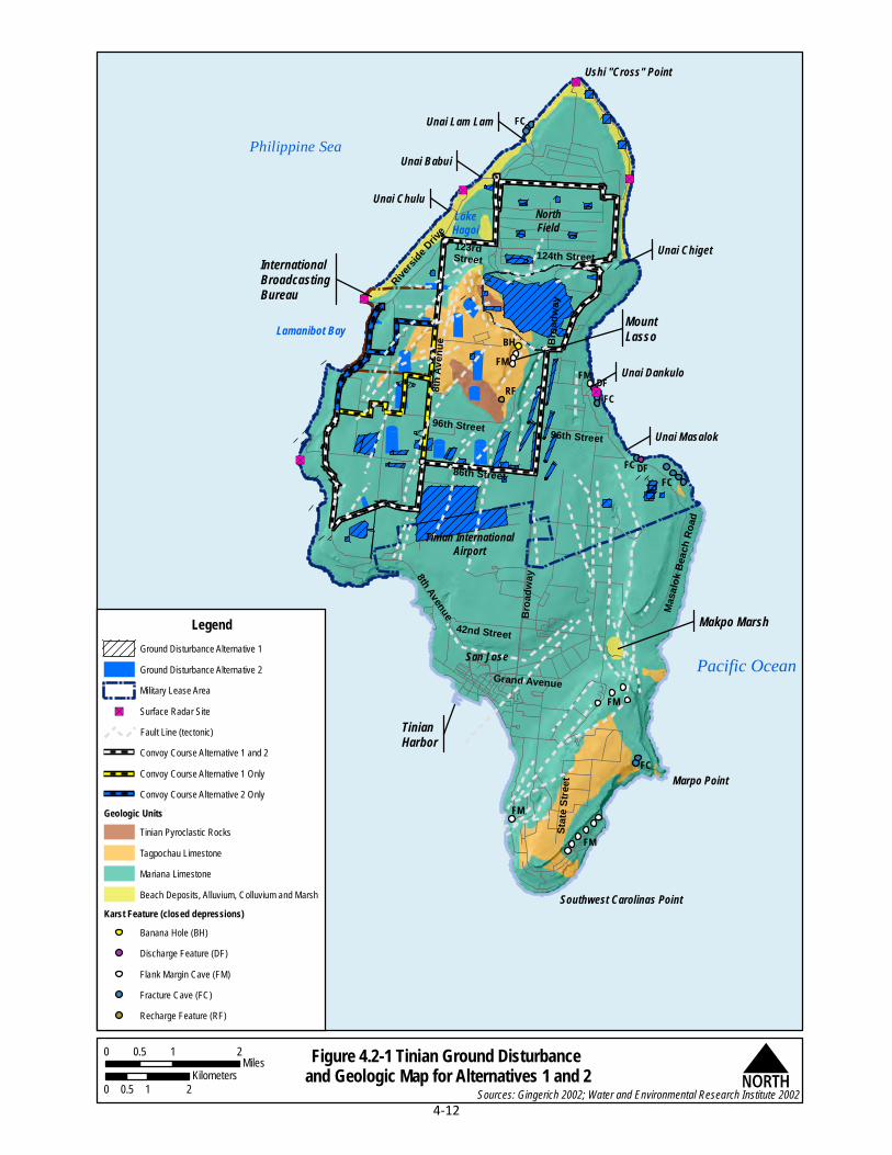
Seismic Activity. Earthquakes are a type of seismic activity caused by movements of the earth's crust and originate at distances of zero to hundreds of miles underground (U.S. Geological Survey 2014). One surface manifestation of earthquakes is the displacement of the earth’s crust commonly known as fault lines or ruptures. As shown in Figure 4.2-1, fault lines underlie portions of the proposed support facilities, roadways, infrastructure, and training facilities. To the extent practicable, construction directly on fault lines would be avoided. However, for those portions of the construction footprint which could not be moved to avoid fault lines, engineering designs would be employed to minimize potential effects from earth movement along fault lines. Buildings, facilities, and infrastructure would be designed, situated, and constructed in adherence to Unified Facility Criteria recommendations for seismic protection.
Landslides. The majority of the proposed construction (i.e., base camp, airport improvements, Munitions Storage Area, port improvements, and most of the training and support facilities) would be located on relatively level ground and would not increase the risk of landslides. However, a few portions of the supporting infrastructure for roadways would be located in areas of high topographic relief which could increase the potential for landslides. Resource management measures such as engineering design for construction, erosion controls, and protective barriers would be employed to reduce the potential for landslides to occur as a result of construction.
Liquefaction. Most of the Tinian Alternative 1 footprint is underlain by consolidated limestone bedrock that is not subject to liquefaction in the event of an earthquake. However, portions of the port improvements would be constructed near the coast on artificial fill materials or other unconsolidated materials that could fail due to liquefaction. An engineering study would be conducted for the site of the proposed port improvements prior to construction to evaluate subsurface conditions and determine design and construction procedures for seismic safety. Port improvements would also be constructed in adherence with Unified Facilities Criteria recommendations for seismic safety to minimize potential hazards associated with ground movement and liquefaction.
Tsunami Inundation. Construction activities associated with Tinian Alternative 1 are largely located inland and would not remove a substantial topographic barrier that would increase the likelihood of tsunami inundation. Construction of an amphibious landing area at Unai Chulu would not increase the likelihood of tsunami inundation in that area because the remaining surrounding limestone shelf would continue to protect the shoreline and the landing area would not significantly change the wave behavior.
Based on the above analysis and implementation of resource management measures listed in Section 4.2.2, Tinian Alternative 1 construction activities would result in less than significant direct and indirect impacts due to geologic hazards.
"S
"S
"S
"S
"S
"S
NorthField
Tinian InternationalAirport
San Jose
Lamanibot Bay
Unai Chulu
Unai Lam Lam
Ushi "Cross" Point
Unai Chiget
Unai Masalok
Marpo Point
Southwest Carolinas Point
LakeHagoi
Philippine SeaUnai Babui
Unai Dankulo
State
Stre
et
Grand AvenueMa
salok
Bea
ch R
oad
Broa
dway
42nd Street
8th Avenue
86th Street
96th Street 96th Street8th
Aven
ue
123rdStreet
Riversid
e Drive
124th Street
Broa
dway
Pacific Ocean
TinianHarbor
MountLasso
Makpo Marsh
InternationalBroadcastingBureau
FM
FM
FC
FM
FCDFFC
FCDFFM
FMBH
RF
FC
Figure 4.2-1 Tinian Ground Disturbance and Geologic Map for Alternatives 1 and 2
LegendGround Disturbance Alternative 1Ground Disturbance Alternative 2Military Lease Area
"S Surface Radar SiteFault Line (tectonic)Convoy Course Alternative 1 and 2Convoy Course Alternative 1 OnlyConvoy Course Alternative 2 Only
Geologic UnitsTinian Pyroclastic RocksTagpochau LimestoneMariana LimestoneBeach Deposits, Alluvium, Colluvium and Marsh
Karst Feature (closed depressions) Banana Hole (BH)Discharge Feature (DF)Flank Margin Cave (FM)Fracture Cave (FC)Recharge Feature (RF)
Sources: Gingerich 2002; Water and Environmental Research Institute 2002N
0 1 20.5Miles
0 1 20.5Kilometers
4-12

CJMT EIS/OEIS Chapter 4, Environmental Consequences April 2015 Draft Geology and Soils
4-13
Soils 4.2.3.1.1.3
Under Tinian Alternative 1, newly created impervious surface areas that would be constructed for the port improvements, base camp, Munitions Storage Area, airport improvements, road improvements, and training and support facilities for Tinian Alternative 1 would comprise approximately 562 acres (227 hectares) and represent less than 4% of the overall project footprint (i.e., Military Lease Area, airfield improvements, port improvements). This would create a minimal increase in stormwater runoff, as compared with existing conditions. Stormwater management through infrastructure improvements under Alternative 1 would include best management practices (e.g., retention ponds, swales, silt fences) to manage the increased runoff from impervious surfaces and minimize soil erosion in surrounding areas. Specific resource management measures include development and implementation of an erosion control measures, stormwater pollution prevention measures, and a stormwater management measures.
Construction-specific stormwater best management practices would be implemented to provide erosion and sediment control during the construction period (see Appendix D, Best Management Practices). These include employing on-site measures, such as retention ponds, swales, silt fences, fiber rolls, gravel bag berms, mulch, and erosion control blankets that reduce soil erosion and the flow and velocity of stormwater and minimize the transport of soils and sediment off-site. Roadway-specific best management practices would be used in the design and construction of the proposed access roads and vehicle training courses. Through compliance with the CNMI Earthmoving and Erosion Control Regulations and implementation of engineering controls and stormwater best management practices, construction activities would not substantially increase the rate of erosion and soil loss under Alternative 1.
Based on the above analysis and implementation of resource management measures identified in Section 4.2.2, Tinian Alternative 1 construction activities would result in less than significant direct and indirect impacts to soils.
Prime Farmland Soils
There are approximately 1,474 acres (597 hectares) of prime farmland soils on Tinian, with approximately 72% (1,054 acres [427 hectares]) located within the Military Lease Area. The Tinian Alternative 1 construction footprint includes approximately 220 acres (89 hectares) of area identified as prime farmland soils or 15% of the total prime farmland soils on the island. The majority of those soils (205 acres [83 hectares]) would not be permanently altered as a result of the construction activities that would primarily consist of vegetation clearance within Range Complex A. Therefore, implementation of Tinian Alternative 1 would result in less than significant direct and indirect impacts to prime farmland soils during the construction phase.
Operation Impacts 4.2.3.1.2
Support Facilities, Roadways, and Utilities 4.2.3.1.2.1
After construction is completed, ongoing operational activities are expected to involve only minor changes to topography, geology, and soils as a result of operational activities (e.g., maintenance, use) at support facilities, roadways, and utilities. These activities would not increase the potential for geologic hazards to occur.

CJMT EIS/OEIS Chapter 4, Environmental Consequences April 2015 Draft Geology and Soils
4-14
Training Facilities 4.2.3.1.2.2
Impacts to topography, geologic units, and soils would occur as a direct result of operational training activities described in Section 2.4, Tinian Alternatives. In addition, maintenance activities (e.g., vegetation maintenance, vehicle and foot maneuvers, munitions use) could also impact soils.
Range Control would be responsible for maintaining access roads, configuring ranges and training areas, and maintaining training areas in usable condition. The training facilities would be managed in accordance with Marine Corps Order 3550.10, Policies and Procedures for Range and Training Area
Management (DoN 2005). Additional resource management measures would include implementation of facilities management policies and procedures for controlling erosion such as maintaining vegetation, drainage ways, and turf on the ranges; and allowing vegetation to re-establish in the training and support facilities. Vegetation within objective areas (i.e., target location) would be maintained at a minimum of 6 inches (15 centimeters) above the ground surface, which would provide ground cover and root systems to hold soil in place.
Range Complex A. As described in Section 2.4, Tinian Alternatives, operational activities at Range Complex A would include the use of high explosives within the High Hazard Impact Area. Munitions would be thrown, fired at, or dropped on targets within the High Hazard Impact Area. Target placements would be located in areas of moderate to low slope and thus detonation of high explosives in these areas would not be expected to have an increase on the potential for landslides. In addition, these operational activities could create munitions impact craters within the upper 6 feet (2 meters) of the underlying geologic units (Army Corps of Engineers 1961) over a 527-acre (213-hectare) area. However, these operations would not substantially impact the overall function of the geologic units within the High Hazard Impact Area because these craters would be relatively shallow compared to the overall thickness of the limestone formation.
Operational activities would include ground combat training in conjunction with aviation support activities. This type of training would include the use of high explosive munitions. Earthquakes are caused by movements of the earth's crust and originate at distances of zero to hundreds of miles underground (U.S. Geological Survey 2014). To date, there is no evidence linking earthquake activity with the use of explosives by humans (U.S. Geological Survey 2014). Therefore, training activities would not increase the potential for seismic activity.
Soil erosion could occur within Range Complex A when lands are cleared and or disturbed on a regular basis and thus decrease overall soil productivity and inhibit plant growth in those areas. Approximately 205 acres (83 hectares) of prime farmland soils are located within the High Hazard Impact Area, resulting in these soils to likely be precluded from future agricultural uses. This represents a potential permanent loss of approximately 14% of Tinian’s prime farmland soils due to the potential presence of unexploded ordnance and change in the character and productivity of the soil due to detonation of munitions, controlled burns for vegetation maintenance, and/or potential presence of munitions constituents (see Section 4.16, Hazardous Materials and Waste).
Range Complex B. As described in Section 2.4, Tinian Alternatives, within Range Complex B, personnel would move via vehicles (wheeled and tracked) along established roads and pathways and by foot over these same roads and pathways as well as open areas within the range complex. Personnel would employ their weapons systems aiming at target objective areas within the range complex. These

CJMT EIS/OEIS Chapter 4, Environmental Consequences April 2015 Draft Geology and Soils
4-15
activities would not create substantial changes to topography; alter the function of geologic units or soil productivity; or increase the potential for a geologic hazard to occur.
Range Complex C. Within Range Complex C, personnel would move primarily on foot to firing points where they would employ their weapons systems aiming at target objective areas within the range complex. These activities would not create substantial changes to topography; alter the function of geologic units or soil productivity; or increase the potential for a geologic hazard to occur except in the Multi-purpose Unknown Distance Range where approximately 14 acres (6 hectares) of prime farmland soils are located which will be permanently altered due to repeated heavy use which would alter soil productivity; therefore, they would be removed from use as prime farmland soils.
Range Complex D. Within Range Complex D, personnel would move on foot to firing points where they would employ their weapons systems aiming at target objective areas within the range complex. These activities would not create substantial changes to topography; alter the function of geologic units or soil productivity; or increase the potential for a geologic hazard to occur.
Military Lease Area-wide Training. As described in Section 2.4, Tinian Alternatives, some types of training would involve training assets that are distributed in areas other than Range Complexes A, B, C, and D. These training operations include Convoy Course training and Tracked Vehicle Driver’s Course training, aviation activities, amphibious training, and foot maneuvering.
Convoy Course Training. Convoy Course training would involve movement of wheeled vehicles along the course and employment of weapons systems aimed at Convoy Course engagement areas adjacent to the course. These activities would not result in a substantial change in topography or function of the geologic units because training would be limited to established routes and engagement areas and thus not create additional impervious surfaces. These activities would not increase the potential for a geologic hazard to occur. Approximately 1 acre (0.4 hectare) of prime farmland soils located in a Convoy Course engagement area would be permanently altered due to repeated heavy use which would alter soil productivity; therefore, they would be removed from use.
Tracked Vehicle Driver’s Course Training. Tracked Vehicle Driver’s Course training would involve movement of tracked vehicles along the established course. These activities would not result in a substantial change in topography, function of the geologic units, or soil productivity because training would be limited to the established routes and thus not create additional impervious surfaces. These activities would not increase the potential for a geologic hazard to occur.
Aviation Activities. Aviation activities associated with the Tinian RTA would be limited to take offs and landings of fixed-wing aircraft from the Landing Zone at North Field and from Tinian International Airport; take offs and landings of rotor and tilt-rotor aircraft at Landing Zones within the Military Lease Area and Tinian International Airport; and aviation support training associated with Range Complexes A, B, C, and D. Unmanned aircraft systems (i.e., drones) would take off and land from Landing Zones as well as other open areas. Aviation activities would not create substantial changes to topography, alter the function of geologic units, or decrease soil productivity. These activities would not increase the potential for a geologic hazard to occur.
Amphibious Training. Wave and hydrodynamic modeling conducted for the amphibious landing ramp that would be constructed at Unai Chulu indicates that minimal changes in nearshore and along-beach current velocity and wave height would occur due to the operation of the ramp, and therefore would

CJMT EIS/OEIS Chapter 4, Environmental Consequences April 2015 Draft Geology and Soils
4-16
not result in substantial changes to beach topography (Appendix J, Amphibious Beach Landing Site
Engineering and Coastal Processes Analyses).
As described in Section 2.4, Tinian Alternatives, tactical amphibious training at Unai Chulu would involve Amphibious Assault Vehicles, Landing Craft Air Cushion vessels, inflatable boats, and combat swimmers. This is the only location proposed for tactical Amphibious Assault Vehicle landings. At Unai Babui and Unai Masalok, tactical amphibious training would include Landing Craft Air Cushion vessels, inflatable boats, and combat swimmers. At Unai Lam Lam, tactical amphibious training would include inflatable boats and combat swimmers. At the Port of Tinian, administrative amphibious training would take place at the old boat ramp.
When landing and launching Amphibious Assault Vehicles, the tracks would come in contact with the ocean bottom to depths of up to 12 feet (4 meters) and this could potentially alter the underwater topography in the landing area. For this reason, landing and launching of Amphibious Assault Vehicles during training operations would be strictly limited to the amphibious landing area at Unai Chulu for tactical landings and the old boat ramp at the Port of Tinian for administrative landings. Use of these established landing areas during the landing and launching of Amphibious Assault Vehicles would not substantially alter coastal processes that could result in erosion of the nearshore topography.
Training involving Amphibious Assault Vehicles and/or Landing Craft Air Cushion vessels would disturb the sandy beaches at Unai Babui, Unai Chulu, and Unai Masalok similar to that from normal wave action during stormy conditions (DoN 2010a), resulting in localized disturbance of soils and beach substrates. The affected beaches consist of mixed sand and coral rubble that are resistant to compaction. Landing Craft Air Cushion vessels would be on “full cushion” (i.e., fully inflated) for beach landings and are designed not to compact the sand (DoN 2010a). Amphibious Assault Vehicles are tracked vehicles and, by design, distribute weight to minimize impacts to the beach (DoN 2010a). However, Amphibious Assault Vehicle operational impacts could lead to loss of beach sand through entrainment and transport of sand off the beach by the vehicles, and through abrasion and crushing of the beach sand. If this loss is greater than the rate of natural supply of sand to the beach, the beach could gradually erode over time. Because of the limited volume of sand, even small amounts of erosion could have noticeable impacts (Appendix J, Amphibious Beach Landing Site Engineering and Coastal Processes Analyses). Training involving inflatable boats and combat swimmers would minimally disturb sandy beaches at Unai Babui, Unai Chulu, Unai Masalok, and Unai Lam Lam. After amphibious operations, beach topography would be returned to pre-training conditions to the extent possible using non-mechanized means such as hand-held tools. Because the vehicles would be operated to minimize impacts to beaches, and because beaches would be returned to the extent possible to their pre-training condition following the operation, long-term compaction of sand would not be expected to occur.
As part of all amphibious training, personnel and equipment would come and go from the beaches using designated routes. Amphibious Assault Vehicles would use the designated Tracked Vehicle Driver’s Course. Landing Craft Air Cushion vessels would on- and off-load equipment and personnel at the designated beaches (Unai Babui, Unai Chulu, Unai Masalok). Tracked vehicles would utilize the Tracked Vehicle Driver’s Course, wheeled vehicles on- and off-loaded from Landing Craft Air Cushion vessels would utilize designated roadways as well as the Tracked Vehicle Driver’s Course; and pedestrians on- and off-loaded from Landing Craft Air Cushion vessels would use the Tracked Vehicle Drivers Course, roadways, or foot paths. By using designated landing areas, courses, roadways, and pathways,

CJMT EIS/OEIS Chapter 4, Environmental Consequences April 2015 Draft Geology and Soils
4-17
amphibious training would not result in a substantial change in topography, geologic units, soil productivity, or result in an increase in the potential for geologic hazards to occur.
Foot Maneuvering. Foot maneuvering would occur over a wide area which would include established training courses, roadways, pathways, and trails as well as open areas. These activities would not result in a substantial change in topography or function of underlying geologic units, soil productivity, or result in an increase in the potential for geologic hazards to occur because pedestrian activities would have lesser impact to soil cohesion and vegetation.
Based on the analysis above and implementation of resource management measures identified in Section 4.2.2, Tinian Alternative 1 operations would result in less than significant direct and indirect impacts to topography and geology. Operations would result in a significant direct impact to prime farmland soils due to the permanent loss of 15% of Tinian’s prime farmland soils, mostly within the High Hazard Impact Area.
4.2.3.2 Tinian Alternative 2
Construction Impacts 4.2.3.2.1
Construction impacts associated with Tinian Alternative 2 would be similar to those described for Tinian Alternative 1 (Section 4.2.3.1). Appendix F, Geology and Soils Technical Memo, provides a detailed characterization of the topographic, geologic, and soil disturbances that could occur as a result of construction activities under Tinian Alternative 2. Table 4.2-2 provides a summary of the ground disturbance, slope, geologic units, soil conditions, prime farmland soils, and geologic hazards associated with construction under Tinian Alternative 2. Figure 4.2-1 depicts the differences in ground disturbance between Tinian Alternative 1 and Tinian Alternative 2.
Impacts to geology and soils resulting from Tinian Alternative 2 construction activities would be similar to those described for Tinian Alternative 1 with the following exceptions:
The land area associated with Tinian Alternative 2 construction activities is larger compared to Alternative 1, because Alternative 2 would include the southern Battle Area Complex and five additional engagement areas associated with the Convoy Course. Tinian Alternative 2 would thus disturb an additional 123 acres (50 hectares) or approximately 7% more than Tinian Alternative 1 for a total of 2,025 acres (820 hectares).
The impervious surface areas that would be constructed for Tinian Alternative 2 would comprise approximately 785 acres (319 hectares), which is an 18% increase compared to Tinian Alternative 1 but is about 4% of the total land area within the Military Lease Area. The additional impervious surfaces in Tinian Alternative 2 are related to additional objective areas in the Battle Area Complex and associated Urban Assault Course, as well as the Convoy Course engagement areas which are considered impervious surfaces due to repeated use and compaction of the soils.
Through construction activities, Tinian Alternative 2 would disturb approximately 115 acres (46 hectares) more of limestone formations than Tinian Alternative 1 for a total 1,678 acres (679 hectares). This represents a 0.5% increase compared with Tinian Alternative 1. This represents a total of 7% disturbance of these formations across Tinian.

CJMT EIS/OEIS Chapter 4, Environmental Consequences April 2015 Draft Geology and Soils
4-18
Table 4.2-2. Summary of Ground Disturbance, Slope, Geologic Units, Soil Conditions, Prime Farmland Soils, and Geologic Hazards Associated with Construction Under Tinian Alternative 2
Description
Approximate Area of Ground
Disturbance (acres)
Approximate Newly Created
Impervious Surface (acres)
Elevation (feet)
Slope Geologic
Units Soil Conditions
Approximate Prime Farmland Soils1 in
acres Geologic Hazards
Port Improvements (Same as Alternative 1)
5 5 0 to 33 <1% to 2%
Mariana Limestone
Slow runoff; Slight erosion
factor None
Potential for liquefaction and
tsunami inundation
Airfield Improvements (Same as Alternative 1)
41 41 243 to 270 <1% Mariana
Limestone
Slow runoff; Slight erosion
factor None Fault lines
Base Camp (Same as Alternative 1)
257 30 254 to 279 1% Mariana
Limestone
Slow runoff; Slight erosion
factor None Fault lines
Munitions Storage Area (Same as Alternative 1)
38 8 235 to 259 1% Mariana
Limestone
Slow runoff; slight erosion
factor None None
Road Improvements (includes Tracked Driver Vehicle Drivers Course and the Convoy Course)
295 295 0 to 314 Variable
Mariana Limestone, Tagpochau Limestone,
Tinian Pyroclastics
Slow to rapid runoff; slight to severe erosion
factors
None Fault lines
Range Complex A (Same as Alternative 1)
527 0 145 to 285 Variable
Mariana Limestone, Tagpochau Limestone,
Tinian Pyroclastics
Slow to medium runoff; slight to medium erosion
factors
205 Fault lines

CJMT EIS/OEIS Chapter 4, Environmental Consequences April 2015 Draft Geology and Soils
4-19
Table 4.2-2. Summary of Ground Disturbance, Slope, Geologic Units, Soil Conditions, Prime Farmland Soils, and Geologic Hazards Associated with Construction Under Tinian Alternative 2
Description
Approximate Area of Ground
Disturbance (acres)
Approximate Newly Created
Impervious Surface (acres)
Elevation (feet)
Slope Geologic
Units Soil Conditions
Approximate Prime Farmland Soils1 in
acres Geologic Hazards
Range Complex B (Same as Alternative 1)
47 47 125 to 290
1% to 11%
Mariana Limestone
Ponded, very slow, to medium runoff; slight to medium erosion
factors
None Fault lines
Range Complex C 157 157 85 to 310 1% to
11% Mariana
Limestone
Slow to rapid runoff; slight to severe erosion
factors
25 Fault lines
Range Complex D (Same as Alternative 1)
475 22 35 to 115 1% to 9%
Mariana Limestone
Slow to rapid runoff; slight to severe erosion
factors
None Fault lines
Military Lease Area-wide Training Facilities (includes Convoy Course engagement areas)
180 180 Variable Variable
Beach Deposits, Alluvium,
Colluvium, Marsh,
Mariana Limestone
and Tagpochau Limestone
Slow to rapid runoff; slight to severe erosion
factors
None Fault lines
Amphibious Training Area (Same as Alternative 1)
3 0 0 to 15 5% to 15%
Beach Deposits
Slow runoff; slight to severe erosion factors
None Potential for
tsunami inundation
Total 2,025 785 - - - - 230 - Notes: 1Prime farmland soils identified within the footprint of the facility. Operational footprint is the same as construction footprint, except where noted otherwise.

CJMT EIS/OEIS Chapter 4, Environmental Consequences April 2015 Draft Geology and Soils
4-20
Through construction activities, Tinian Alternative 2 would disturb approximately 10 acres (4 hectares) more of prime farmland soils, as compared to Tinian Alternative 1, for a total of 230 acres (93 hectares). This represents an increase of approximately 1% as compared to Tinian Alternative 1. As described for Tinian Alternative 1, most of the identified prime farmland soils in the proposed action area would not be permanently altered as a result of construction activities.
Tinian Alternative 2 would follow the same resource management measures as those described in Section 4.2.2. The very small increase in the amount of on-land construction, limestone formation disturbance, soil disturbance, and earthwork does not change the effectiveness of the resource management measures at avoiding or minimizing adverse impacts.
Based on the above analysis and implementation of resource management measures, Tinian Alternative 2 construction activities would result in less than significant impacts to topography, geology, and soils.
Operation Impacts 4.2.3.2.2
Impacts resulting from Tinian Alternative 2 operations would be similar to those described under Tinian Alternative 1. However, the addition of a southern Battle Area Complex and associated Urban Assault Course, as well as five additional engagement areas associated with the Convoy Course, results in a larger area used for foot and vehicle maneuvers and training. Implementation of Tinian Alternative 2 would also follow the same resource management measures as described in Section 4.2.2. The small acreage increase located proximate to areas already contemplated for training and sharing their same physical characteristics does not change the impact conclusions described for Tinian Alternative 1.
As described under construction impacts for Tinian Alternative 2, approximately 230 acres (93 hectares) of prime farmland soils would be included in the footprint of Tinian Alternative 2. Only a small portion of the identified prime farmland soils in the Tinian Alternative 2 footprint would represent temporary losses, and would be available for agricultural production after the duration of military use has ended. However, approximately 205 acres (83 hectares) of prime farmland soils would be located within the High Hazard Impact Area for Tinian Alternative 2, resulting in these soils to likely be precluded from future agricultural uses. This represents a potential permanent loss of approximately 14% of Tinian’s prime farmland soils due to the potential presence of unexploded ordnance and change in the character and productivity of the soil. Compared with Tinian Alternative 1, approximately 11 acres (4 hectares) of additional prime farmland soils are located within Range Complex C that are associated with the additional objective areas under Tinian Alternative 2; this results in a total of 25 acres (10 hectares) of prime farmland soils associated with Range Complex C for Tinian Alternative 2. These prime farmland soils would be permanently altered due to repeated heavy use which would alter soil productivity; therefore, they would be removed from use. In total, approximately 230 acres (93 hectares) of prime farmland soils would be lost to future use under Tinian Alternative 2 which is approximately 16% of Tinian’s total prime farmland soils. The loss of these prime farmland soils for future use is considered a significant impact to prime farmland soils under operations.
Based on the above analysis and implementation of resource management measures described in Section 4.2.2, Tinian Alternative 2 operations would result in less than significant direct and indirect impacts to topography and geology. Tinian Alternative 2 would result in a significant direct impact to

CJMT EIS/OEIS Chapter 4, Environmental Consequences April 2015 Draft Geology and Soils
4-21
prime farmland soils due to the permanent loss of 16% of Tinian’s prime farmland soils within the Military Lease Area.
4.2.3.3 Tinian Alternative 3
Construction Impacts 4.2.3.3.1
Construction impacts for Tinian Alternative 3 would be similar to those described under Section 4.2.3.1, Tinian Alternative 1. Appendix F, Geology and Soils Technical Memo, provides a characterization of the topographic, geologic, and soil disturbances that could occur as a result of construction activities under Tinian Alternative 3. Table 4.2-3 provides a summary of the ground disturbance, slope, geologic units, soil conditions, prime farmland soils, and geologic hazards associated with construction under Tinian Alternative 3. Figure 4.2-2 depicts the differences in ground disturbance between Tinian Alternative 1 and Tinian Alternative 3.
Impacts resulting from Tinian Alternative 3 construction activities would be similar to those described for Tinian Alternative 1 with the following exceptions:
Slightly more on-land construction would take place for Alternative 3 as compared with Alternative 1 because Alternative 3 would include the southern Battle Area Complex and five additional engagement areas associated with the Convoy Course; however, it would not include the northern Battle Area Complex and thus impact less acreage than Tinian Alternative 2 which has two Battle Area Complexes. Tinian Alternative 3 would disturb approximately 101 acres (41 hectares) or about 5% more than Tinian Alternative 1 for an approximate total of 2,002 acres (811 hectares).
The impervious surface areas that would be constructed for the port improvements, base camp, Munitions Storage Area, airport improvements, and training and support facilities for Tinian Alternative 3 would comprise a total of approximately 763 acres (309 hectares) or approximately 15% more impervious surface than Tinian Alternative 1, approximately 4% of the total land area within the Military Lease Area. The additional impervious surfaces associated with Tinian Alternative 3 that are not part of Tinian Alternative 1 are located in the Convoy Course engagement areas which would become impervious as a result of repeated use.
Through construction activities, Tinian Alternative 3 would disturb approximately 93 acres (38 hectares) more of limestone formations than Tinian Alternative 1 for a total 1,656 acres (670 hectares). This represents a 0.5% increase in disturbance of these formations as compared to Tinian Alternative 1 for a total of 7% disturbance of these formations across Tinian.
Through construction activities, Tinian Alternative 3 would temporarily disturb approximately 10 acres (4 hectares) more prime farmland soil, as compared to Tinian Alternative 1, for a total of 230 acres (93 hectares). This represents an increase of approximately 1% compared to Tinian Alternative 1 and represents 16% of the total prime farmland soils across Tinian.
Tinian Alternative 3 would follow the same resource management measures as those described in Section 4.2.2. The very small difference in the amount of on-land construction, limestone formation disturbance, soil disturbance, and earthwork would not change the effectiveness of the resource management measures at avoiding or minimizing adverse impacts.

CJMT EIS/OEIS Chapter 4, Environmental Consequences April 2015 Draft Geology and Soils
4-22
Table 4.2-3. Summary of Ground Disturbance, Slope, Geologic Units, Soil Conditions, Prime Farmland Soils, and Geologic Hazards Associated with Construction Under Tinian Alternative 3
Description
Approximate Area of Ground
Disturbance (acres)
Approximate Newly Created
Impervious Surface (acres)
Elevation (feet)
Slope Geologic
Units Soil Conditions
Approximate Prime Farmland Soils1 in
acres Geologic Hazards
Port Improvements (Same as Alternative 1)
5 5 0 to 33 <1% to 2%
Mariana Limestone
Slow runoff; Slight erosion
factor None
Potential for liquefaction and
tsunami inundation
Airfield Improvements (Same as Alternative 1)
41 41 243 to 270 <1% Mariana
Limestone
Slow runoff; Slight erosion
factor None Fault lines
Base Camp (Same as Alternative 1)
257 30 254 to 279 1% Mariana
Limestone
Slow runoff; Slight erosion
factor None Fault lines
Munitions Storage Area (Same as Alternative 1)
38 8 235 to 259 1% Mariana
Limestone
Slow runoff; slight erosion
factor None None
Road Improvements (includes Tracked Driver Vehicle Drivers Course and the Convoy Course)
295 295 0 to 314 Variable
Mariana Limestone, Tagpochau Limestone,
Tinian Pyroclastics
Slow to rapid runoff; slight to severe erosion
factors
None Fault lines
Range Complex A (Same as Alternative 1)
527 0 145 to 285 Variable
Mariana Limestone, Tagpochau Limestone,
Tinian Pyroclastics
Slow to medium runoff; slight to medium erosion
factors
205 Fault lines

CJMT EIS/OEIS Chapter 4, Environmental Consequences April 2015 Draft Geology and Soils
4-23
Table 4.2-3. Summary of Ground Disturbance, Slope, Geologic Units, Soil Conditions, Prime Farmland Soils, and Geologic Hazards Associated with Construction Under Tinian Alternative 3
Description
Approximate Area of Ground
Disturbance (acres)
Approximate Newly Created
Impervious Surface (acres)
Elevation (feet)
Slope Geologic
Units Soil Conditions
Approximate Prime Farmland Soils1 in
acres Geologic Hazards
Range Complex B (Same as Alternative 1)
47 47 125 to 290
1% to 11%
Mariana Limestone
Ponded, very slow, to medium runoff; slight to medium erosion
factors
None Fault lines
Range Complex C (Same as Alternative 2)
157 157 85 to 310 1% to 11%
Mariana Limestone
Slow to rapid runoff; slight to severe erosion
factors
25 Fault lines
Range Complex D 453 0 35 to 115 1% to
9% Mariana
Limestone
Slow to rapid runoff; slight to severe erosion
factors
None Fault lines
Military Lease Area-wide Training Facilities (includes Convoy Course engagement areas) (Same as Alternative 2)
180 180 Variable Variable
Beach Deposits, Alluvium,
Colluvium, Marsh,
Mariana Limestone
and Tagpochau Limestone
Slow to rapid runoff; slight to severe erosion
factors
None Fault lines
Amphibious Training Area (Same as Alternative 1)
3 0 0 to 15 5% to 15%
Beach Deposits
Slow runoff; slight to severe erosion factors
None Potential for
tsunami inundation
Total 2,003 763 - - - - 230 Notes: 1Prime farmland soils identified within the footprint of the facility. Operational footprint is the same as construction footprint, except where noted otherwise.

"S
"S
"S
"S
"S
"S
NorthField
Tinian InternationalAirport
San Jose
Lamanibot Bay
Unai Chulu
Unai Lam Lam
Ushi "Cross" Point
Unai Chiget
Unai Masalok
Marpo Point
Southwest Carolinas Point
LakeHagoi
Philippine SeaUnai Babui
Unai Dankulo
State
Stre
et
Grand AvenueMa
salok
Bea
ch R
oad
Broa
dway
42nd Street
8th Avenue
86th Street
96th Street 96th Street8th
Aven
ue
123rdStreet
Riversid
e Drive
124th Street
Broa
dway
Pacific Ocean
TinianHarbor
MountLasso
Makpo Marsh
InternationalBroadcastingBureau
FM
FM
FC
FM
FCDFFC
FCDFFM
FMBH
RF
FC
Figure 4.2-2 Tinian Ground Disturbance and Geologic Map for Alternatives 1 and 3
LegendGround Disturbance Alternative 1Ground Disturbance Alternative 3Military Lease Area
"S Surface Radar SiteFault Line (tectonic)Convoy Course Alternative 1 and 3Convoy Course Alternative 1 OnlyConvoy Course Alternative 3 Only
Geologic UnitsTinian Pyroclastic RocksTagpochau LimestoneMariana LimestoneBeach Deposits, Alluvium, Colluvium and Marsh
Karst Feature (closed depressions) Banana Hole (BH)Discharge Feature (DF)Flank Margin Cave (FM)Fracture Cave (FC)Recharge Feature (RF)
Sources: Gingerich 2002; Water and Environmental Research Institute 2002N
0 1 20.5Miles
0 1 20.5Kilometers
4-24

CJMT EIS/OEIS Chapter 4, Environmental Consequences April 2015 Draft Geology and Soils
4-25
Based on the above analysis and the implementation of resource management measures, construction under Tinian Alternative 3 would result in less than significant impacts to topography, geology, and soils.
Operation Impacts 4.2.3.3.2
Impacts resulting from Tinian Alternative 3 operations would be similar to those described under Tinian Alternative 1. Tinian Alternative 3 would also follow the same resource management measures as described in Section 4.2.2. The only difference is that operational activities would take place over a slightly larger area for Tinian Alternative 3 as compared with Tinian Alternative 1. The small acreage increase located proximate to areas already contemplated for training and sharing their same physical characteristics does not change the impact conclusions described for Tinian Alternative 1.
As described under construction impacts for Tinian Alternative 3, approximately 230 acres (96 hectares) of prime farmland soils would be included in the footprint of Tinian Alternative 3. Only a small portion of the identified prime farmland soils in the Tinian Alternative 3 footprint would represent temporary losses, and would be available for agricultural production after the duration of military use has ended. However, approximately 205 acres (83 hectares) of prime farmland soils would be located within the High Hazard Impact Area for Tinian Alternative 3, resulting in these soils to likely be precluded from future agricultural uses. Compared with Tinian Alternative 1, approximately 11 acres (4 hectares) of additional prime farmland soils are located within Range Complex C that are associated with the additional objective areas under Tinian Alternative 3; this results in a total of 25 acres (10 hectares) of prime farmland soils associated with Range Complex C for Tinian Alternative 3. These prime farmland soils will be permanently altered due to repeated heavy use which would alter soil productivity; therefore, they would be removed from use. In total, approximately 230 acres (93 hectares) of prime farmland soils would be lost to future use under Tinian Alternative 3 which is approximately 16% of Tinian’s total prime farmland soils. The loss of these prime farmland soils for future use is considered a significant impact to prime farmland soils under operations.
Based on the above analysis, Tinian Alternative 3 operations would result in less than significant direct and indirect impacts to topography and geology. Tinian Alternative 3 operations would result in a significant direct impact to prime farmland soils due to the permanent loss of 16% of Tinian’s prime farmland soils within the Military Lease Area.
4.2.3.4 Tinian No-Action Alternative Activities during the periodic military non-live-fire training exercises on Tinian in the Military Lease Area would have short-term and minor effects on geology and soils due to vehicle and troop movements. The military operations on the four ranges proposed in the 2010 Record of Decision in the Guam and CNMI Military Relocation EIS (DoN 2010b) would not significantly change the topography, effect geologic units, increase the potential for soil erosion and sedimentation, or intensify risks from geologic hazards (see Table 3.2-2; DoN 2010c). Other military training in the Mariana Islands Range Complex does not overlie Tinian’s main potable water supply, so soil compaction during training activities would not affect infiltration of surface water into the groundwater (see Table 3.1-2; DoN 2010a and Section 4.3, Water
Resources). Training activities would not alter the functions of the geologic units or soils. Therefore, the no-action alternative would result in less than significant impacts to geology and soils on Tinian.

CJMT EIS/OEIS Chapter 4, Environmental Consequences April 2015 Draft Geology and Soils
4-26
4.2.3.5 Summary of Impacts for Tinian Alternatives Table 4.2-4 provides a comparison of the potential impacts to geology and soils resources for the three Tinian alternatives and the no-action alternative.
Table 4.2-4. Summary of Impacts for Tinian Alternatives
Resource Area Tinian
(Alternative 1) Tinian
(Alternative 2) Tinian
(Alternative 3) No-Action Alternative
Geology and Soils Construction Operation Construction Operation Construction Operation Construction Operation Topography LSI LSI LSI LSI LSI LSI LSI LSI
Geology LSI LSI LSI LSI LSI LSI LSI LSI
Soils LSI LSI LSI LSI LSI LSI LSI LSI
Prime Farmland Soils LSI SI LSI SI LSI SI LSI LSI Legend: LSI = less than significant impact; SI = significant impact. Shading is used to highlight the significant impacts.

CJMT EIS/OEIS Chapter 4, Environmental Consequences April 2015 Draft Geology and Soils
4-27
Pagan 4.2.4
4.2.4.1 Pagan Alternative 1
Construction Impacts 4.2.4.1.1
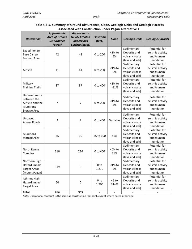
Proposed development and construction activities associated with Pagan Alternative 1 would involve approximately 764 acres (310 hectares) of ground disturbance as described below. The discussion of construction impacts for Pagan Alternative 1 is divided into three parts: (1) Topography; (2) Geology; and (3) Soils. Table 4.2-5 provides a summary of the ground disturbance, newly created impervious surface, elevation, slope, geologic units, and geologic hazards under Pagan Alternative 1. The discussion of construction period impacts to topography, geology, and soils is provided in the section below.
Topography 4.2.4.1.1.1
Construction of the training and support facilities, military training trails, and related infrastructure associated with Pagan Alternative 1 would include clearing, grubbing, and grading; excavating (cut); and filling. Appendix F, Geology and Soils Technical Memo, summarizes the areas of ground disturbance.
Potential slope instability and changes to surface drainage resulting from the changes to the existing slopes would be avoided or minimized by using resource management measures identified in Section 4.2.2 and described in Appendix D, Best Management Practices. The following paragraphs generally describe the topographic disturbances associated with Pagan Alternative 1.
Airfield Clear Zone. Approximately 484 acres (196 hectares) would require 100% vegetation clearance to 6 inches (15 centimeters) in height in order to create an airfield clear zone around the 41-acre (17-hectare) expeditionary airfield. It would also encompass the 42-acre (17-hectare) expeditionary base camp/bivouac area. The ground disturbance for these facilities is described below.
Grading and removal of lava rock (basalt) at the airfield (approximately 41 acres [17 hectares]). Construction methods used to remove the lava rock would include use of explosive charges to discretely break apart the lava rock into manageable pieces. Heavy equipment would be used to remove the rock materials for use as gravel and fill materials at other locations. Approximately 615,000 cubic yards (470,000 cubic meters) of lava rock would be removed under the construction activities associated with the airfield.
Grading and vegetation clearance the expeditionary base camp/bivouac area (approximately 42 acres [17 hectares]).
Construction of a concrete berm and pad for the Forward Arming and Refueling Point and a concrete pad for the Hot Cargo Pad would be completed.
Military Training Trails. Approximately 22 miles (35 kilometers) of existing all-terrain vehicle trails would be widened, cleared, and graded only where necessary to create 14-foot (4-meter)-wide military training trails (approximately 39 acres [16 hectares]) to accommodate vehicle traffic.
Some training facilities would have a reduced infiltration rate due to the compaction associated with the proposed training activity and may contribute to increased stormwater flows. Therefore, as a conservative estimate, these areas are included in construction impacts as impervious surface.
CJMT EIS/OEIS Chapter 4, Environmental Consequences April 2015 Draft Geology and Soils
4-28
Table 4.2-5. Summary of Ground Disturbance, Slope, Geologic Units and Geologic Hazards Associated with Construction under Pagan Alternative 1
Description
Approximate Area of Ground
Disturbance (acres)
Approximate Newly Created
Impervious Surface (acres)
Elevation (feet)
Slope Geologic Units Geologic Hazards
Expeditionary Base Camp/ Bivouac Area
42 42 0 to 200 <1% to 5%
Sedimentary Deposits and volcanic rocks (lava and ash)
Potential for seismic activity
and tsunami inundation
Airfield 41 41 0 to 200 <1% to 5%
Sedimentary Deposits and volcanic rocks (lava and ash)
Potential for seismic activity
and tsunami inundation
Military Training Trails 37 37 0 to 400 <1% to
>31%
Sedimentary Deposits and volcanic rocks (lava and ash)
Potential for seismic activity
and tsunami inundation
Unpaved route between the Airfield and the Munitions Storage Area
7 7 0 to 250 <1% to 5%
Sedimentary Deposits and volcanic rocks (lava and ash)
Potential for seismic activity
and tsunami inundation
Unpaved Access Roads 2 2 0 to 400 Variable
Sedimentary Deposits and volcanic rocks (lava and ash)
Potential for seismic activity
and tsunami inundation
Munitions Storage Area 35 10 25 to 100 <1%
Sedimentary Deposits and volcanic rocks (lava and ash)
Potential for seismic activity
and tsunami inundation
North Range Complex 216 216 0 to 400 <0% to
31%
Sedimentary Deposits and volcanic rocks (lava and ash)
Potential for seismic activity
and tsunami inundation
Northern High Hazard Impact Target Areas (Mount Pagan)
319 0 0 to 1,870
<1% to 5%
Sedimentary Deposits and volcanic rocks (lava and ash)
Potential for seismic activity
and tsunami inundation
Isthmus High Hazard Impact Target Area
64 0 0 to 1,700
<1 to 31+%
Sedimentary Deposits and volcanic rocks (lava and ash)
Potential for seismic activity
and tsunami inundation
Total 764 355 - - - - Note: Operational footprint is the same as construction footprint, except where noted otherwise.

CJMT EIS/OEIS Chapter 4, Environmental Consequences April 2015 Draft Geology and Soils
4-29
Munitions Storage Area. Grading and clearing for a Munitions Storage Area would be completed (approximately 10 acres [4 hectares]) and concrete pads and fencing would be constructed. Unpaved gravel access routes between the Munitions Storage Area and the airfield would be cleared and graded (10 acres [4 hectares]). Total ground disturbance during the construction phase would be 35 acres (14 hectares).
North Range Complex. Training facilities within the North Range Complex including Landing Zones, Field Artillery Indirect Fire Range and Mortar Range firing positions, and a Field Artillery Direct Fire Range firing position (216 acres [88 hectares]) would be cleared and graded.
In addition, approximately 319 acres (130 hectares) inside the northern High Hazard Impact Area have been identified for target placement. Targets are generally located in relatively flat (10-20% slopes), sparsely vegetated areas of barren lava flow which would not require grading or clearing. However, two target placements are located in areas with forest vegetation which would require some vegetation clearance. The target boxes are assumed to be pervious surfaces.
Approximately 64 acres (26 hectares) inside the isthmus High Hazard Impact Area would be cleared for target placement and firebreaks. The target area is located across a section of the isthmus with an average slope of 23%. The target boxes are assumed to be pervious surfaces.
South Range Complex. The South Range Complex would not require any construction footprint.
Impacts resulting from changes to topography (e.g., slope instability and alteration of surface drainage patterns) could occur when excavation and fill activities take place to form level surfaces for RTA facilities and military training trails. Although the overall Pagan Alternative 1 construction footprint encompasses different elevations across the northern part of the island (see Chapter 2, Proposed Action
and Alternatives, Figure 2.5-6), most of the earth work would occur in areas of modest elevation changes. The most extensive construction with potential for impacts to topography would be associated with the improvements for the airfield and expeditionary base camp/bivouac area. However, this work would take place on the surface of the near-level existing grass airfield. The removal of the lava from the airfield footprint would require a substantial change in topography in a limited area (i.e., on the airfield); however, no substantial grade changes (e.g., excavation of steep hills or fill of canyons) would be required within the expeditionary base camp/bivouac area. For this reason, moderate changes in grade are anticipated to provide a buildable surface for improving the airfield and constructing the expeditionary base camp/bivouac area under Pagan Alternative 1.
Resource management measures would be used to minimize any potential slope instability and changes to surface drainage. As described in Section 2.5.1.1, construction would occur in short phases over an 8 to 10 year period, which would reduce the amount of soil disturbance and erosion that would occur at any given time, allowing vegetation to re-establish and re-stabilize soils in construction-disturbed areas.
Construction outside of the expeditionary base camp and airfield for the Pagan Alternative 1 would be very limited and localized to specific components (e.g., firing points and targets) within the High Hazard Impact Areas and Live-Fire Maneuver Area and military training trails. In the small areas where construction would involve levelling/filling steeper natural slopes, impacts to slope stability would be avoided or minimized by using resource management measures described in Section 4.2.2. Construction activities associated with Pagan Alternative 1 would not involve large-scale cut and fill work in areas of

CJMT EIS/OEIS Chapter 4, Environmental Consequences April 2015 Draft Geology and Soils
4-30
major elevation changes and therefore would not substantially alter the surrounding landscape, reducing slope stability, or alter surface drainage patterns.
Based on the analysis presented above and the implementation of resource management measures, Pagan Alternative 1 construction activities would result in less than significant direct and indirect impacts to topography.
Geology 4.2.4.1.1.2
Geologic Units
The construction footprint associated with Pagan Alternative 1 is located in an area of lava and ash deposits, with limited portions of the shoreline supporting raised reef deposits. Additionally, there is an estimated 13.1 million tons (11.9 million metric tons) of commercial grade pozzolan, a material used as an additive to strengthen concrete (Ding and Wilson 2007). Construction activities under Pagan Alternative 1 would disturb portions of the pozzolan deposit and other geologic units. However, these disturbances would be limited in aerial extent and most would be temporary, resulting in no loss of function of the geologic unit.
Based on the analysis above and the resource management measures identified in Section 4.2.2, Pagan Alternative 1 construction activities would result in less than significant impacts to geologic units.
Geologic Hazards
Pagan is located in an active seismic zone and is home to two active volcanos. As a result, in the potential for geologic hazards such as seismic activity (i.e., earthquakes, fault ruptures), volcanic activity, landslides, and potential tsunami inundation exists.
Seismic Activity. Seismic activity on Pagan is related to its close proximity to the Mariana Trench subduction zone and volcanic activity on the island. There would be no permanent buildings under the Pagan alternatives and therefore adherence to Unified Facility Criteria recommendations for seismic protection would not apply. Most of the Pagan Alternative 1 footprint is underlain by consolidated volcanic rock that would not be subject to liquefaction in the event of an earthquake. Surface level construction activities would not interfere with these geological processes and would not increase the risk of seismic activity.
Volcanic Activity. Construction activities would occur primarily on the northern portion of Pagan, in the immediate vicinity of Mount Pagan, an active volcanic vent. Volcanic activity occurs when there are changes to the density of magma or pressure surrounding magma deep within the earth. Surface level construction activities would not interfere with these geological processes and would not increase the risk of volcanic activity.
Landslides. The majority of the proposed construction (i.e., the airfield and expeditionary base camp/bivouac area) would be located on relatively level ground. As such, land-disturbing activities in association with construction of these facilities are not likely to increase the risk of landslides. However, some components of the training and support facilities (e.g., military training trails) would be located in areas of high topographic relief resulting in some potential for slope instability. This potential would be reduced through the use of standard engineering practices. Clearance of targets in the High Hazard

CJMT EIS/OEIS Chapter 4, Environmental Consequences April 2015 Draft Geology and Soils
4-31
Impact Areas would not involve any changes in topography – only vegetation clearance for target placement.
Tsunami Inundation
Construction activities associated with Pagan Alternative 1 are largely located inland. Construction of military training trails near the coast would not remove a substantial topographic barrier that would increase the likelihood of tsunami inundation.
Pagan Alternative 1 construction activities would not significantly increase the potential for geologic hazards. Therefore, Pagan Alternative 1 would result in less than significant direct and indirect impacts with respect to geologic hazards.
Soils 4.2.4.1.1.3
As part of construction, approximately 764 acres (310 hectares) would be disturbed under Pagan Alternative 1. Construction and future repeated use for training would result in approximately 355 acres (144 hectares) of newly created impervious surfaces. There is a potential for increased erosion, compaction, and soil loss from physical disturbance caused by construction activity and changes to existing topography. However, project design and construction would incorporate best management practices (see Appendix D, Best Management Practices) to minimize erosion as required by CNMI Earthmoving and Erosion Control Regulations, including construction-specific stormwater best management practices. These practices would be implemented to provide erosion and sediment control during the construction period. This would be done by employing on-site measures that would reduce the flow and velocity of stormwater runoff and minimize the transport of soils and sediment off-site, whenever possible. Best management practices would be used in the design and construction of the proposed military training trails. Through compliance with the CNMI Earthmoving and Erosion Control Regulations and implementation of stormwater best management practices, construction activities would not substantially increase the rate of erosion and soil loss under Pagan Alternative 1.
Based on the analysis above and the implementation of resource management measures, Pagan Alternative 1 would result in less than significant direct and indirect impacts to soils.
Operation Impacts 4.2.4.1.2
Under Pagan Alternative 1, use of high explosive munitions (i.e., naval gunfire, ground-based artillery, inert aviation ordnance) in the northern and isthmus High Hazard Impact Areas would impact topography. The use of high-explosive munitions on ground targets in the two High Hazard Impact Areas could trigger localized rockslides/landslides. In the northern High Hazard Impact Area, targets are generally located on relatively flat, sparsely vegetated areas of the lava field, with some exceptions. The target area in the isthmus High Hazard Impact Area would be located across a 64-acre (26-hectare) area on a steep-sloped isthmus (15% slope). Small scale rockslides could occur as a result of high explosive munitions landing in the target area. Outside of the two High Hazard Impact Areas, ongoing training and maintenance activities would not involve alteration of topography other than minor excavation or filling (e.g., repairs to military training trails).
In addition, detonations of high-explosive munitions in the two High Hazard Impact Areas would create munitions impact craters within the upper 6 feet (2 meters) of the underlying geologic unit (Army Corps
CJMT EIS/OEIS Chapter 4, Environmental Consequences April 2015 Draft Geology and Soils
4-32
of Engineers 1961). These impact craters would be limited to the target areas and would not substantially alter the function of the geologic units.
Most of the Pagan Alternative 1 footprint is underlain by consolidated volcanic rock that would not be subject to liquefaction in the event of an earthquake. In addition, there would not be a change to soil and/or bedrock conditions that would increase vulnerability to seismic activity. Earthquakes are caused by movements of the earth’s crust, and originate at distances of tens to hundreds of miles underground. There is no evidence linking earthquake activity with the use of explosives (U.S. Geological Survey 2014).
Impacts to soils would occur as a direct result of training and maintenance activities (e.g., vegetation maintenance, vehicle and foot maneuvers, and ordnance use). The impervious surface areas associated with Pagan Alternative 1 would include approximately 355 acres (144 hectares). The increase of impervious surface would be relatively small compared to the overall land area and would create a minimal increase in runoff as compared with existing conditions. Stormwater management through infrastructure improvements associated with Pagan Alternative 1 would include best management practices to manage the increased runoff from the new impervious surfaces and minimize soil erosion in surrounding areas.
Vehicle and foot maneuver areas in the North Range Complex would be limited to proposed military training trails or areas easily accessible due to relatively flat terrain and lack of vegetation (i.e., barren lava). Maneuver areas in the South Range Complex would be limited to accessible pathways within densely vegetated areas.
Targets would be established over approximately 319 acres (130 hectares) in the northern High Hazard Impact Area. A total of eight targets are proposed in an array around Mount Pagan, three to the northeast and five to the south and southwest. Size of the target areas varies from 5 acres (2 hectares) to 135 acres (55 hectares). Slopes on the target areas range between 5% and 25%. Six of the eight targets would be located on barren ground or barren lava where there would be minimal soil or vegetation cover. However, a total of approximately 91 acres (37 hectares) at two of the proposed high explosive targets would be located in forested areas. Within the northern High Hazard Impact Area stormwater runoff would continue to follow the natural drainage patterns. Soil erosion associated with operations within the northern High Hazard Impact Area is expected to be limited because targets have relatively low slopes and are largely devoid of soil cover (i.e., barren lava field). Best management practices would be utilized in areas that require vegetation clearance to prevent soil erosion during storm events.
A single target area would be established over approximately 64 acres (26 hectares) in the isthmus High Hazard Impact Area. The target area is underlain by weathered volcanic material (i.e., clay material). Soil erosion associated with operations within the isthmus High Hazard Impact Area is expected to be limited because targets are largely devoid of soil cover (i.e., barren lava). Best management practices would be utilized in areas within the isthmus High Hazard Impact Area that require vegetation clearance to prevent soil erosion during storm events. In the isthmus High Hazard Impact Area, stormwater runoff controls would not be practicable due to the steep topography. Although the average slope of the target area within the isthmus High Hazard Impact Area would be approximately 30%, the areas around the plateau are steep; therefore, some localized soil erosion could occur during heavy rainfall events but will not result in significant impacts to soil erosion. Soil-laden stormwater runoff could flow through the

CJMT EIS/OEIS Chapter 4, Environmental Consequences April 2015 Draft Geology and Soils
4-33
vegetation in the cleared area around the targets and eventually into vegetated areas on the steep slopes of the isthmus and into the nearshore waters.
Areas disturbed by operational activities on hillsides would erode much faster than on flat ground, as stormwater runoff would have greater erosive energy as it moves downhill. Soil compaction, disturbance, and movement would be minimized by limiting the use of wheeled and tracked vehicles to established military training trails or accessible open areas and limiting ordnance expenditures to target areas within the established range complexes.
Range Control would be responsible for maintaining support facilities, training facilities, and military training trails. The training and support facilities would be managed in accordance with Marine Corps Order 3550.10, Policies and Procedures for Range and Training Area Management, which is designed to ensure safe, efficient, effective, and environmentally sustainable use of ranges (DoN 2005). Procedures would be implemented for managing stormwater; controlling erosion; maintaining vegetation, drainage ways, and turf within the RTA; and restricting vehicle and foot maneuver activities to designated areas. Range military training trails would be maintained to minimize erosion. Vegetation would be allowed to re-establish at the training and support facilities to minimize the potential for soil erosion. Periodic vegetation maintenance would occur as necessary.
Pagan Alternative 1 operations would not significantly increase the potential for impacts to topography, geologic units, geologic hazards, and soils. Therefore, Pagan Alternative 1 operations would result in less than significant direct and indirect impacts to topography, geologic units, geologic hazards, and soils.
4.2.4.2 Pagan Alternative 2
Construction Impacts 4.2.4.2.1
Construction activities associated with Pagan Alternative 2 would use the same construction methods as those described for Pagan Alternative 1 and would take place in the same general topography, geology, and soils. Geologic hazards would also be similar to those described under Pagan Alternative 1. The primary difference is that Pagan Alternative 2 would have no isthmus High Hazard Impact Area and the northern High Hazard Impact Area would be smaller than that for Pagan Alternative 1. In addition, there would be two additional Landing Zones and one less mortar firing position resulting in 68 acres (28 hectares) less ground disturbance. Under Pagan Alternative 2, the same area of the northern High Hazard Impact Area would be improved for target placement as described under Pagan Alternative 1. A summary of ground disturbance for Pagan Alternative 2 is provided below in Table 4.2-6.
Pagan Alternative 2 would also follow the same construction resource management measures as those described for Pagan Alternative 1 (see Section 4.2.2). The difference in the amount of on-land construction, soil disturbance, and earthwork would not change the effectiveness of the construction resource management measures at avoiding or minimizing adverse impacts to geology and soils.
Pagan Alternative 2 construction activities would not significantly increase the potential for impacts to topography, geologic units, geologic hazards, and soils. Therefore, construction activities associated with Pagan Alternative 2 would result in less than significant direct and indirect impacts to topography, geologic units, geologic hazards, and soils.

CJMT EIS/OEIS Chapter 4, Environmental Consequences April 2015 Draft Geology and Soils
4-34
Table 4.2-6. Summary of Ground Disturbance, Slope, Geologic Units and Geologic Hazards Associated with Construction under Pagan Alternative 2
Description
Approximate Area of Ground
Disturbance (acres)
Approximate Newly Created
Impervious Surface (acres)
Elevation (feet)
Slope Geologic Units Geologic Hazards
Expeditionary Base Camp/ Bivouac Area (Same as Alternative 1)
42 42 0 to 200 <1% to 5%
Sedimentary Deposits and volcanic rocks (lava and ash)
Potential for seismic activity
and tsunami inundation
Airfield (Same as Alternative 1)
41 41 0 to 200 <1% to 5%
Sedimentary Deposits and volcanic rocks (lava and ash)
Potential for seismic activity
and tsunami inundation
Military Training Trails (Same as Alternative 1)
37 37 0 to 400 <1% to >31%
Sedimentary Deposits and volcanic rocks (lava and ash)
Potential for seismic activity
and tsunami inundation
Unpaved route between the Airfield and the Munitions Storage Area
7 7 0 to 250 <1% to 5%
Sedimentary Deposits and volcanic rocks (lava and ash)
Potential for seismic activity
and tsunami inundation
Unpaved Access Roads (Same as Alternative 1)
2 2 0 to 400 Variable
Sedimentary Deposits and volcanic rocks (lava and ash)
Potential for seismic activity
and tsunami inundation
Munitions Storage Area (Same as Alternative 1)
35 10 25 to 100 <1%
Sedimentary Deposits and volcanic rocks (lava and ash)
Potential for seismic activity
and tsunami inundation
North Range Complex 213 213 0 to 400 <0% to
31%
Sedimentary Deposits and volcanic rocks (lava and ash)
Potential for seismic activity
and tsunami inundation
Northern High Hazard Impact Target Area (Same as Alternative 1 [Mount Pagan])
319 0 0 to 1,870
<1% to 5%
Sedimentary Deposits and volcanic rocks (lava and ash)
Potential for seismic activity
and tsunami inundation
Total 696 347 - - - - Note: Operational footprint is the same as construction footprint, except where noted otherwise. The isthmus High Hazard
Impact Area is not included in Pagan Alternative 2.

CJMT EIS/OEIS Chapter 4, Environmental Consequences April 2015 Draft Geology and Soils
4-35
Operation Impacts 4.2.4.2.2
Pagan Alternative 2 operational activities would be similar to those described under Pagan Alternative 1. The main difference with Pagan Alternative 2 is that there would be more area for ground maneuver training due to a smaller northern High Hazard Impact Area and the absence of the isthmus High Hazard Impact Area (areas where maneuver would not be allowed due to the presence of unexploded ordnance). Due to the larger maneuver area, there would be more surface area potentially affected by vehicle and foot maneuvers. Target placements within the northern High Hazard Impact Area would be the same under both alternatives but there would be no target placements in the South Range Complex.
Pagan Alternative 2 would follow the same resource management measures as those described for Pagan Alternative 1 (see Section 4.2.2). The differences in the size of the High Hazard Impact Area and vehicle maneuver areas and number of vehicle maneuvers would not change the effectiveness of the resource management measures in preventing and minimizing adverse impacts to geology and soils.
Pagan Alternative 2 operations would not significantly increase the potential for impacts to topography, geologic units, geologic hazards, and soils. Therefore, Pagan Alternative 2 operations would result in less than significant direct and indirect impacts to topography, geologic units, geologic hazards, and soils.
4.2.4.3 Pagan No-Action Alternative Potential activities on Pagan under the no-action alternative would include the continuation of periodic visits to the island by small eco-tourism cruises, scientific surveys, and military non-live-fire training related to search and rescue. Ocean going vessels would periodically moor offshore with small boats bringing small groups of people ashore. Helicopters or small planes may transport visitors to and from the island. In all cases, known activities associated with the no-action alternative would have minor effects on geology and soils on Pagan.
4.2.4.4 Summary of Impacts for Pagan Alternatives Table 4.2-7 provides a comparison of the potential impacts to geology and soils resources for the two Pagan alternatives and the no-action alternative.
Table 4.2-7. Summary of Impacts for Pagan Alternatives
Resource Area Pagan
(Alternative 1) Pagan
(Alternative 2) No-Action Alternative
Geology and Soils Construction Operation Construction Operation Construction Operation Topography LSI LSI LSI LSI LSI LSI Geology LSI LSI LSI LSI LSI LSI Soils LSI LSI LSI LSI LSI LSI Legend: LSI = less than significant impact.