Embed Size (px)
Citation preview

State of Washington MON C. WALLGREN, Governor
Department of Conservation and Development ART G ARTON, Director
DIVISION OF MINES AND GEOLOGY SHELDON L . GLOVER, Supervisor
Bulletin No. 36
Geology and Ore Deposits of the Sultan Basin,
Snohomish County, Washington
By
WARD CARITHERS and A. K. GUARD
O LYMPIA STATE PRINTING PLANT
1945
Fo1· sale by Department of Conservation and Development, Olympia, Washingwn. Price 50 cen ts .

CONTENTS Page
Foreword . . . . . . . . . . . . . . . . . . . . . . . . . . . . . . . . . . . ... . . . . . . . . . . . . . . . . . . . . . . 5
Introduction . . . . . . . . . . . . . . . . . . . . . . . . . . . . . . . . . . . . . . . . . . . . . . . . . . . . . . . . . 7 Location and accessibility. . . . . . . . . . . . . . . . . . . . . . . . . . . . . . . . . . . . . . . . . . . 7 Field work and acknowledgments.... . ..... . ..... . ..... . ..... . ...... 8 Scope of the report. . . . . . . . . . . . . . . . . . . . . . . . . . . . . . . . . . . . . . . . . . . . . . . . 8 Source of map data. . . . . . . . . . . . . . . . . . . . . . . . . . . . . . . . . . . . . . . . . . . . . . . . 8 Selected bibUography . . . . . . . . . . . . . . . . . . . . . . . . . . . . . . . . . . . . . . . . . . . . . . 9
Physiography . . . . . . . . . . . . . . . . . . . . . . . . . . . . . . . . . . . . . . . . . . . . . . . . . . . . . . 9 Topography . . . . . . . . . . . . . . . . . . . . . . . . . . . . . . . . . . . . . . . . . . . . . . . . . . . . . . . 9 Drainage . . . . . . . . . . . . . . . . . . . . . . . . . . . . . . . . . . . . . . . . . . . . . . . . . . . . . . . . . 10 Climate and vegetat ion . .. ..... . ......... . .......................... 10 Glaciation . . . . . . . . . . . . . . . . . . . . . . . . . . . . . . . . . . . . . . . . . . . . . . . . . . . . . . . . 11
Geologic formations . . . . . . . . . . . . . . . . . . . . . . . . . . . . . . . . . . . . . . . . . . . . . . . . . . 13 Bedded rocks ......... .. ..... . ................ . ........... . . . ..... 14
Old metamorphic series. . . . . . . . . . . . . . . . . . . . . . . . . . . . . .. . . . . . . . . . . . 14 Conglomerate-argillite series . . . . . . . . . . . . . . . . . . . . . . . . . . . . . . . . . . . . 15 Quaternary deposits . . . . . . . . . . . . . . . . . . . . . . . . . . . . . . . . . . . . . . . . . . . . 18
Igneous rocks . . . . . . . . . . . . . . . . . . . . . . . . . . . . . . . . . . . . . . . . . . . . . . . . . . . . . 18 Peridotite . . . . . . . . . . . . . . . . . . . . . . . . . . . . . . . . . . . . . . . . . . . . . . . . . . . . . 18 Quartz diorite .. . ........... . ... . .... . . .. . . . . ... . . . ............ 22 Dikes ..... . . .. .... . .. . ...... .... ... . .. . ... ... ...... . ... . . ... . .. 26
Ore deposits . . . . . . . . . . . . . . . . . . . . . . . . . . . . . . . . . . . . . . . . . . . . . . . . . . . . . . . . . 28 Lode deposits . . . . . . . . . . . . . . . . . . . . . . . . . . . . . . . . . . . . . . . . . . . . . . . . . . . . . 28
Origin ... . .. . .. . . .... . . .... . ... .. ... . ............... . . . .. ...... 28 Structure . . . . . . . . . . . . . . . . . . . . . . . . . . . . . . . . . . . . . . . . . . . . . . . . . . . . . . 28 Mineralogy . . . . . . . . . . . . . . . . . . . . . . . . . . . . . . . . . . . . . . . . . . . . . . . . . . . . 29 Pa.ragenesis . . . . . . . . . . . . . . . . . . . . . . . . . . . . . . . . . . . . . . . . . . . . . . . . . . . . 33 Stages of m ineral ization .. ....... . ..... . ..... . . .... . ..... . . . ... .. 33
Magmatic segregations . . . . . . . . . . . . . . . . . . . . . . . . . . . . . . . . . . . . . . . . . . . . . 35 Replacement deposits ........ . . .... . ..... . ........................ . 36 Placer deposits . . . . . . . . . . . . . . . . . . . . . . . . . . . . . . . . . . . . . . . . . . . . . . . . . . . . 36
Mines and prospects. . . . . . . . . . . . . . . . . . . . . . . . . . . . . . . . . . . . . . . . . . . . . . . . . . . 36 History and production . . . . . . . . . . . . . . . . . . . . . . . . . . . . . . . . . . . . . . . . . . . . . 36 WilUamson Creek area .................. . ...... . ..... . ..... . .. . .. . . 39
"45" mine . . . . . . . . . . . . . . . . . . . . . . . . . . . . . . . . . . . . . . . . . . . . . . . . . . . . . 39 Milwaukee prospect ................. . ...... . ..... . ..... . . . . ... . 46 Silver Horseshoe prospect ... . ......... . ...... . . .. .. . . . .. . . . . ..... 47 Little Chief prospect ...... . ..... . ..... . ..... . .. .... ..... . .. ... . . 49 Alpha and Beta placer claim s .... . ... . . . ..... . ..... . .. . .. . .. . .... 50 Ala-Dickson prospect . . . . . . . . . . . . . . . . . . . . . . . . . . . . . . . . . . . . . . . . . . . 50
North Fork of the Sultan River area. . . . . . . . . . . . . . . . . . . . . . . . . . . . . . . . . 51 Sultan King prospect ................ . . ...... . ..... . . . ... . .. . .. . . 51 Florence Rae mine. . . . . . . . . . . . . . . . . . . . . . . . . . . . . . . . . . . . . . . . . . . . . . 55 Doris prospect . . . . . . . . . . . . . . . . . . . . . . . . . . . . . . . . . . . . . . . . . . . . . . . . . 60 Sultan Basin Mining Co.. . . . . . . . . . . . . . . . . . . . . . . . . . . . . . . . . . . . . . . . 62 Sunr ise prospect . . . . . . . . . . . . . . . . . . . . . . . . . . . . . . . . . . . . . . . . . . . . . . . 68 48-55 (garnet) prospect .... . ..... . .......... . ..... . .. . ...... . ... 70 Kelly Creek prospect. . . . . . . . . . . . . . . . . . . . . . . . . . . . . . . . . . . . . . . . . . . . 71 Mountain Cedar prospect. . . . . . . . . . . . . . . . . . . . . . . . . . . . . . . . . . . . . . . . 71 John Newhouse prospect . ....... . ..... . .. . .. . ..... . ..... . . . .... . 73

Table of Contents 3
Page Elk Creek area ............... . . . .............. ...... .............. 74
Marvel prospect . . . . . . . . . . . . . . . . . . . . . . . . . . . . . . . . . . . . . . . . . . . . . . . . 74 Jones prospect .............. .. ................. .. .............. 74 Blue Stone prospect. . . . . . . . . . . . . . . . . . . . . . . . . . . . . . . . . . . . . . . . . . . . . 74
South Fork of the Sultan River al'ea ..... . . ........ . .. . .. ............ 74 St. Theresa prospect .......... . ........ .. ................ ....... . 74 Golden Eagle prospect ................ . ............... .. ......... 75 Kromona prospect .................. ...... .............. . ... .. .. 75
Outlying properties . . . . . . . . . . . . . . . . . . . . . . . . . . . . . . . . . . . . . . . . . . . . . . . . 78 Border Queen prospect. . . . . . . . . . . . . . . . . . . . . . . . . . . . . . . . . . . . . . . . . . 78 Lockwood pyrite deposit ............ . ........................... 79
Index . . .... . ........... . ..... . ........... . . . . . . ....... . .. . . ......... 87

ILLUSTRATIONS Page
PLATE 1. Geologic map and sections of the Sultan Basin , Snohomish
FIGURE
County, Wash ... ....... . ..... . ........... ... ....... In pocket
2. A, Lower part of the Sultan Basin from Olney Pass;
B, East rim of the Sultan Basin at Headlee Pass ...... .. ........ 19
3. A, South s ide of Big Four Mountain from Copper Lake;
B, Sheep Gap Mountain from the Sultan King prospect;
C, Upper part of the South Fork of the Sultan River Valley .... 20
1.
2.
3. 4.
5.
6.
7.
8.
9.
10.
11.
12.
13.
14.
15.
16.
17.
18.
Index map of Washington showing location of the Sultan Basin . . . . . . . . . . . . . . . . . . . . . . . . . . . . . . . . . . . . . . . . . . . 7
Sketch of surface in the upper Williamson Creek area, showing claims . . . . . . . . . . . . . . . . . . . . . . . . . . . . . . . . . . . . . . . . 39
Plan and section of part of "45" mine workings . . ... . ... .. ... 40
Idealized sketch of the Silver Horseshoe No. 1 vein ...... • .. . 48
Sketch of workings at the Little Chief prospect. ............. 49
Map of the Sultan King prospect, showing patented claims and workings .. . .......... . ................. .. ......... 51
Assay plan of drift in No. 1 tunnel, Sultan King prospect ..... 53
Geologic sketch of Red Mountain area, showing mining claims . . . . . . . . . . . . . . . . . . . . . . . . . . . . . . . . . . . . . . . . . . 56
Plan of Florence Rae mine . . . . . . . . . . . . . . . . . . . . . . . . . . . . . . . . 57
Geologic map and sections of the Florence Rae mine area. . . . 57
Sketch of workings at the Doris prospect. ................... 61
Plan and section of old Iowa mjne, Sultan Basin Mining Co ... 63
Sketch of s urface and workings on the Calumet claim, Sultan Basin Mining Co.. . . . . . . . . .. . . . . .. . . . . .. . . . . .. . . . 66
Sketch and sections of the Suru-ise prospect . . . . . . . . . . . . . . . . . 68
Sketch of surface and workings at the Mountain Cedar prospect . . . . . . . . . . . . . . . . . . . . . . . . . . . . . . . . . . . . . . . . . . . . . . . 72
Map of the principal workings at the K romona prospect ... .. . 76
Map of the workings at the Border Queen prospect .. . ........ 79
Map of the Lockwood pyrite deposit ................. . ...... 80

FOREWORD
The Sultan Basin area of Snohomish County has held the interest of prospectors and miners for more than 70 years, yet, strangely enough, very little authentic information has been available to the public on the general geology or on the characteristics of the mineral occurrences. Although only about 30 miles airline from tidewater, the area has always been very difficult of access. A county road now reaches the lower part of the basin, and formerly two privately built roads served properties within the basin, but transportation is still a major problem in any development program. If production were assured, it is probable that roads would be built; but lacking roads the development work that is the prerequisite to production is greatly handicapped if not prevented. This deadlock has yet to be solved.
The first mining claim in the basin to be recorded was staked in 1874; since then hundreds of claims have been filed. Many mineral showings have been extensively prospected; a few have had considerable development work done on them; and four properties have records of production. Under the circumstances, it is understandable that rumors should multiply and that vague or contradictory reports should obscure factual data on geology and ore deposits. The field investigations upon which this report is based were made in an effort to resolve the many confusing statements and provide basic information on mineral occurrences. A study of the geology of the area was, of course, a necessary prelimjnary. It is hoped that the data presented will prove useful in geologic correlations between this and adjacent areas and aid in future prospecting and development. The area has very definite production possibilities and warrants the attention of mining interests.
SHELDON L. GLOVER, Supervisor Division of Mines and Geology


GEOLOGY AND ORE DEPOSITS OF THE SULTAN BASIN, SNOHOMISH COUNTY, WASHINGTON
BY w ARD CARITHERS AND A. K. GUARD
INTRODUCTION
LOCATION AND ACCESSIBILITY
The Sultan Basin, as referred to in this report, is the part of central Snohomish County that lies in the upper drainage area of the Sultan River (fig. 1). Early maps suggest that the name 'Sultan Basin' has been applied to only a confined section of this area where several tributaries join to form the main trunk of the river; but miners, prospectors, and others have generally referred to the Sultan Basin as being the entire upper drainage basin, and in this more popular sense the name is used herein. This area is on the western flank of the Cascade Range within the Puget Sound drainage basin. Geographically, it is approximately between latitudes 47° 55' and 48° 03' and longitudes 121 ° 28' and 121 ° 42'. It is an area of about 72 square miles, comprising the northeastern part of the Sultan mining district. Surrounding the basin on the north, east, and
.rg• -
WALL A ··-·· •WALLA _ _ .,_ ••
I 123 ' 119'
FrcuRt: I-Index map o! Washington showing location of the Sultan Basin .

8 Geology and Ore Deposits of the Sultan Basin
south are the Silverton, Monte Cristo, Silver Creek, and Index mining districts. Sultan, the nearest settlement, is a town of about 1,000 population situated 12 miles southwest of the basin on the main line of the Great Northern Railway and on the Stevens Pass highway, U. S. lOA, 25 miles east of Puget Sound. From Sultan, a good road, macadamized for the first 21h miles, leads into the basin through Olney Pass. The road then follows up the North Fork of t he Sultan River, and in 1943 was passable nearly to the head of this stream. During the winter of 1943-44, however, a flood washed out portions of the last 4 mil~s of the road. An uncompleted branch road extends from Olney Pass up the South Fork of the Sultan River for about 21/z miles. Trails lead from the roads to other sections of the basin. There are no permanent residents in the basin, but several cabins are occasionally occupied during the summer months.
FIELD WORK AND ACKNOWLEDGMENTS
Most of the field work for this report was done in the summer of 1943, from July 19 to September 23; two additional weeks in 1944 were spent in and around the basin to gain additional information. Generous cooperation was given by the people who are interested in the mining properties of the basin, and particular thanks are due Mr. and Mrs. Harry Rudebeck, Messrs. Forrest E. Wing, Noah Berridge, C. F. Smith, Nate Jones, and George Startup for their courtesies. Bob Curtiss, acting as guide during three weeks of 1943, was of assistance to the writers in familiarizing them with trails and locations of several properties of the area. The authors are indebted to Sheldon L. Glover and W. A. G. Bennett, Supervisor and Geologist respectively, of the Division of Mines and Geology, for their generous counsel and aid in the preparation of the report.
SCOPE OF THE REPORT
The study of the Sultan Basin was devoted primarily to the mineral deposits, and so the present report deals chiefly with the mines and prospects of the area. The general geology was considered for its relation to the ore deposits, but the details of the complex stratigraphy and the correlation of some Sultan Basin formations with those in other areas are phases of the geology which will require further investigation.
SOURCE OF MAP DAT A
The areal geology of the Sultan Basin was mapped by the writers and is shown on plate 1. The base and topography of this map was adapted from the Sultan, Stilaguamish (Stillaguamish), Skykomish , and Glacier Peak quadrangles of the U. S. Geological Survey. These join at a common point in the basin. The positions of claims and other data shown were taken from a variety of sources,
Int roduction 9
including U. S. Forest Service maps, Chas. F. Metsker's Snohomish County Atlas, maps furnished by claim owners, and field observations. In several instances, data from these sources were contradictory, and it was necessary to adjust the map according to conditions observed in the field. In cases of contradictory positions of legal boundaries, compromises were made. The maps of most underground workings, shown in the various figures, were based on surveys made by the writers with Brunton compass, pacing, and taping.
SELECTED BIBLIOGRAPHY
There are few published reports that deal specifically with the geology and mines of the Sultan Basin. Some geologic reports have been published that cover part of the area adjacent to, or near, the basin, and following is a selected list of publications that give data pertinent to the area studied: SPURR, J. E., The ore deposits of Monte Cristo, Washington: U. S. Geol. Sux
vey 22d Ann. Rept., pt. 2, pp. 777-888, 1901. A paper presenting a detailed geologic description of the area and mines in the district east of the Sultan Basin. Spun concluded that the Monte Cristo ore deposits were deposited in fractures within the country rock from descending surface waters.
THYNG, W. S., Stilaguamish district; Monte Cristo district; Silver Creek district; Index district; in Landes, Henry, and others, The metalliferous resources of Washington except iron: Washington Geo!. Survey Ann. Rept. for 1901, pt. 2, pp. 63-82, 1902. Brief reports of the mines, and general statements regarding the geology of the ai:ea surrounding the Sultan Basin. A few paragraphs describe the "45" mine and the Little Chief prospect.
WEAVER, C. E., Geology and ore deposits of the Index mining district: Washington Geo!. SuTvey Bull. 7, 1912. A report on the geology and mines of the area south of the Sultan Basin. The ore bodies are described as being chiefly enclosed in granodiorite, the predominant rock in the district. This igneous body, which is regarded as Mesozoic in age, intrudes the Gunn Peak metamorphic series of probable Carboniferous age, and both these rocks are overlain by Tertiary volcanic and sedimentary formations.
PATTY, E . N., The metal mines of Washington: Washington Geol. Survey Bull. 23, pp. 279-289, 1921. A brief statement of the geology in the Index and Sultan districts, and descriptions of the Kromona, "45", Mystery (Mountain Cedar), and Sultan (Sultan King) properties.
BROUGHTON, W. A., Inventory of mineral prope1·ties in Snohomish County, Washington: Washington Div. Geology Rept. Inv. 6, pp. 46-50, 1942. A brief statement of the geology, and a catalogue of the mines and prospects in the Sultan district.
PHYSIOGRAPHY
TOPOGRAPHY
The Sultan Basin is on the western edge of the northern Cascade Range and exhibits the bold, rugged topographical features of this region. Altitudes range from 1,200 feet on the Sultan River in

10 Geology and Ore Deposits of the Sultan Basin
the lower part of the basin to more than 5,000 feet on many of the peaks and ridges. Del Campo Peak, on the eastern rim of the basin, is 6,550 feet in altitude, the highest point in the district. Many of the peaks of the basin are spectacular pinnacles connected by sharp, narrow ridges which descend abruptly to the valley floors. In some places the mountains are cut by narrow gorges through which snowfed streams cascade.
DRAINAGE
The drainage of the upper Sultan River is roughly semicircular in area. It is separated from the Stilaguamish, Sauk, and Skykomish drainages by steep, sawtooth ridges on the north, east, and south, and from the Pilchuck River drainage by a low ridge on the west. Four principal streams-Elk Creek, Williamson Creek. and the North and South Forks-converge to form the main trunk of the Sultan River in the lower part of the basin . Here, the valley floor is relatively broad in contrast to the narrow valleys of the four tributaries. At the lower end of this valley, the river leaves the basin and plunges abruptly into a constricted canyon through which it flows to its confluence with the Skykomish River at Sultan, 16 miles down stream. A few miles below the basin, part of the river is diverted for the municipal water supply of the City of Everett ; laws governing sanitary conditions in regard to water pollution are therefore strictly enforced within thfa drainage area.
CLIMATE AND VEGETATION
The climate of the Sultan Basin is typical of that prevailing in the western Cascades. Owing to the extreme difference in altitudes, the region presents a wide variation in weather conditions. The average temperature in the valleys is moderate, both summer and winter, and is only slightly below that recorded on Puget Sound. On the higher peaks and ridges the temperature is, of course, lower. No climatological records are ava ilable for the basin, but the following table© shows mean temperatures for Silverton, Monte Cristo, and Startup. Temperatures of the lower part of the basin may be expected to be about the same as those given for Silverton.
M ean temperatu re by months and m ean ammal tempercitiire
__ S_l•_•t_1o_n_<D __ 1_.1_n_u. Fo-t.. _:u,~.: .1-~prll l l 11 y ~11~ ~ Ir .\ ug. St·1l1. ()Pl. No,·.~~
Sllvr rton ... . ( It) :1:1 .0 ~). I) .11 .0 45. 1 ~l.O 52.0 111,2 l iO,:! :; 1. r, 17.2 :~!,. f) ~ .4 .11),7
)lontc C,·IElO (·I) a.1 .fl ::i.u !"{(,, (; 40.9 45.9 52.R m.o f,:l ,O :-.::., ;,I). " :li-,1 3;;.G 4:;_4
Stnrtup .... . . (7) :l'i.2 42 . -16.0 ;.2.1 ;,a, 61.0 li.i .'.! '"' .4
:'1!).'.! ;,J.I) ~.7 :111 .s iii.
(D Figures in parentheses indicate the num ber of yea rs recorded.
<D U. S. Dept. Agr. Weather Bur .. Climatic summary of the Uni ted St.a tes, sec. 1. Western Washington, to 1930, pp. 23, 24. 1931.

Physiography 11
Humid westerly and southwesterly winds that move in from the Pacific Ocean drop considerable rain when rising over the high rims of the basin; some of the precipitation falls during the winter months as snow, which blankets the higher elevations from November until May. A few of the highest peaks and ridges retain isolated patches of snow throughout the year. The following tables<D give precipitation data from stations at Silverton, Monte Cristo, and Startup.
Precipitati on, average m onthly an d annttal ( in inches and hundredths)
Stolion(D .Jon. Pcb. llor . • \ prll :lll1}' J une .July A11i: •• C!)l. Oct. I Nov. Dec. ----------Sil,•erton .. .. (17) rn.1,1 o.~.s R.SI 5.01 5.49 3.73 J,(l,l 2.70 7.0() 11.25
Mon te Orlsto (5) 15.12 15.,1~ 10.03 1 8.2G S.7S 0..JO 1.1:; 0.72 5.()7 G.55
Ftnrtup .. .. .. (7) O.i l {):. (ti U.2-1 4.17 3.73 2.S8 O.!i:J 2.().3 3.5S 7.24
© Fl11urc,; In 1'" rcntlwscs lncllcntc I he uumbcr " ' yc111·s rccorclrcl.
Slat ton©
Si1 .-ertou .... (11)
l!onte Crl~ to (4)
Sta r tu p . . .. .. (7)
Sn owfall, av erage monthly and annual (in inches and tenths)
,l un . :Ft1h . Mor. ,l1lr ll Mny I J une .1111:r Aug. Ser t. I Oc1. ---- -- -- - - --- -Z'L.& 1;;.s 14. :l. 6 0.5 0 0 0 0 0.7
~l. :'i 4.5 70.2 l;!/, 1 18.: I 2.8 0 0 o.; 2.0
4 .·l 1.0 2 .9 l. l 0 0 0 0 0
0 1,.h:ure,: in 11>1 r c111hc~cs lndlrutc t M num ber nr yr nrF r<'<'orflcd.
15.10 ll.S5
17.89 21.CO
us 8.1).J
Nov. I Dec.
1.3 2;;. 7
4-1. 7 120.2
0.0 5 .1
Annual
93.45
U S.51
56.10
Annuul
Si .S
442.-1
Hl.3
A lush growth of vegetation covers the valley floors and slopes. Most of the area below 3,500 feet, where not too steep, supports western hemlock, Douglas fir, noble fir , western red cedar, and, rarely, western white pine and western yew. Above 3,500 feet the timber is less thick and is mostly alpine spruce, alpine fir, and Alaska cedar. The t imber line is about 5,000 feet in altitude. Brush also grows luxuriantly in the basin and makes travel off the trails and roads difficult; devil's-club, huckleberry, salmonberry, and vine maple are the most common types.
GLACIATION
The work of ice played an important part in the development of the present topographic features of the Sultan Basin. In Pleistocene t ime, when the mountain glaciers of the Cascade Range were moving westward and eastward from the mountains into the lowlands, four glaciers, fed by smaller lateral tongues, moved down the forks
© Op. cit., pp.15, 19, 20 , 23.

12 Geology cmd Ore Deposits of the Sultan Basin ----
of the Sultan River, coalesced in the lower part of the basin, and pushed on westward toward Puget Sound through what is now the valley of the Pilchuck River. U-shaped valleys, cirque lakes and basins, and a few small hanging glaciers remain as evidence of this ice activity.
Continental glaciation, as well, has modified the physiographic features of the area. A deposit of glacial debris forms the low ridge that separates the Sultan from the Pilchuck River watershed. This is apparently a remnant of the terminal moraine of an ice front that was thrust up into the basin from the west. Early writings by Willis and Smith <D and by Bretz @ suggest that the Pleistocene glaciers of the Cascade Range extended out into the Puget Sound Basin and merged with the Puget ice sheet, forming a great piedmont glacier. But more recent work by Mackin@ shows that at least several of the mountain glaciers of the Cascades were on the wane and had receded from the lower parts of the valleys when the last continental ice sheet invaded the Puget Sound region. MackinCD states that "tongues of the Puget glacier * ,:, ,:, pushed up into every major valley along the Cascade front between the Nisqually and the South Fork of the Stilaguamish, and morainal blockades occur in each valley."
Field observations indicate that prior to the invasion of this Puget ice sheet, the present outlet of the Sultan Basin had not yet been established, and the drainage of the Sultan River and the movement of the basin's mountain glaciers were westward through what is now the Pilchuck River Valley. When the Puget Sound Basin was invaded by the final Pleistocene ice sheet, after the recession of the mountain glaciers, a tongue of ice was thrust up into this Sultan-Pilchuck Valley, damming it with ice and morainal material. As a result, water of the Sultan River and from the melting ice front was impounded behind this dam, form ing a lake that extended back into the Sultan Basin for several miles. The elevation of the surface of this body of water was at least 1,600 feet above sea level, as indicated by l acustrine beds of glacial silt 15-25 feet thick which occur on the present valley floor up to this altitude. This glacial lake drained westward, and the ice lobe forced the water to flow along the north flank of Blue Mountain, superimposing a new
<D Willis. Bailey, and Smith. G. 0 .. U. S. Geol. Survey G eo!. Alias. Tacoma folio (no. 54), 1899.
© Bretz, J H .. Glaciation of the Puget Sound ,·egion: Washington Geo I. Survey Bull. 8. pp. 221-225. 1913.
@ Mackin. J. H. . G lacial geology or the Snoqualmie-Cedar area. Washington: Jour. Geology, vol. 49. pp. 449-481. 1941: A geologic interpretation of the failure of the Cedar reservoir. Washington : Univ. of Washington Eng. Exp. Sta. Bull. 107, 1941.
© Idem (Bull. 107). p . 30.

Physiography 13
channel thereon. An enormous volume of debris-laden water probably flowed through this channel during the ice-melting stages, and its erosive action was sufficient not only to eventually drain the glacial lake but also to establish this as the permanent outlet of the basin.
During the active stages of the Sultan-Pilchuck ice lobe, considerable detritus was, no doubt, discharged into the valley that it blockaded. Much of this material has been reworked by the Sultan River, and the former morainal blockade is now represented by the gravel ridge between the lower Sultan Basin and the upper Pilchuck River, and by deposits of gravel that occur on the south slope of Bald Mountain.
It is not known whether the river, in the lower part of the basin, has yet eroded completely through the morainal blockade and down to the level of the original Sultan-Pilchuck channel. If this old channel lies below the present stream level, conditions might be adverse for the use of the Sultan Basin as a water reservoir. If water were impounded behind a proposed dam in the canyon below the basin and raised to a level that would inundate the lower Sultan Basin, seepage might occur through the old gravel-filled channel into the Pilchuck River Valley. The failure of the Cedar River reservoir in King County is due to a somewhat similar geological condition. Testing for the position of bedrock in the lower part of the basin could easily ascertain whether or not this adverse condition exists.
Another interesting economic aspect of the glacial history of the Sultan River concerns the placer-gold deposits that occur several miles below the basin along the lower part of the river. Since about 1880, small-scale placer operations have recovered several thousand dollars in gold from these gravels, and there has been some conjecture as to the source of the metal. It is known that small amounts of gold occur in the glacial tills of the Puget Sound region, and if the authors' interpretation of the Pleistocene history of the Sultan River is correct, a large share of the Sultan placer gold came from the re-working by the river of the morainal material that occupied the old Sultan-Pilchuck Valley. Apparently a large volume of this debris was washed down through the Sultan River Canyon, and the gold could have been naturally concentrated along the lower portions of the canyon where the gradient is less.
GEOLOGIC FORMATIONS
The oldest formation recognized in the Sultan Basin is an extensive and complex series of metamorphosed rocks considered to be of Paleozoic age. This formation is overlain by a younger series of continental beds-conglomerates, sandstones, and argillites-and
14 Geology and Ore Deposits of the Sultan Basin
is intruded by peridotite which is almost completely serpentinized. These formations are intruded by a batholith of quartz diorite which crops out over a large part of the basin. Unconsolidated morainal material and thin deposits of lacustrine clay occur on the valley floors as a result of Pleistocene glaciation. (See pl. 1.)
BEDDED ROCKS
OLD i\IE'.l'APH ORPHIC SERIES
A thick series of metamorphosed rocks, the oldest and most extensive formation, is here called the 'old metamorphic series', a term generally applied to a widespread and similar group of old rocks in western Washington. This series occupies slightly more than half the basin area, cropping out over most of the northwestern part, and extends into adjacent areas except along its southeastern border where it has an irregular contact with a batholith of intrusive biotite-quartz diorite.
The old metamorphic series of the basin is composed of beds of hornfelsic biotite siltstone, argillite, quartzite, schist, serpentine schist, conglomerate, and recrystallized limestone. No volcanic members were recognized but may be present. The stratigraphy of the formation is highly complex, and the relationship of the various members is not known. The beds strike rather consistently N. 5°-20° W. except in the extreme western part of the basin where they trend more westward. Dips are generally steep and alternate in direction from east to west, suggesting a succession of tightly folded and truncated anticlines and synclines.
The series presents a variety in degrees of metamorphism. In areas that are in close proximity to the quartz diorite batholith, a hornfelsic character is common, and considerable alteration and contortion has occurred. Long, drawn-out pebbles in the conglomeratic members as well as intense crinkling of finer-grained beds are usual features. Alteration has resulted in the formation of secondary minerals. Petrographic studies show that finely divided biotite and cloudy irregular crystals of plagioclase, both of secondary origin, are particularly characteristic of the hornfelsic phases. Considerable quartz is usually also present, and some beds are, in fact, quartzite. To the west of the quartz diorite contact, the metamorphism of the series diminishes, and the rocks are darkcolored coarse- and fine-grained a1·gillaceous types interbedded with thin layers of quartzite. In the Olney Pass region the rock is black slaty argillite, interbedded with black and greenish-gray schist. Some of these members are not excessively altered, and bedding is commonly well preserved. The lesser degree of metamorphism shown by some of these rocks probably accounts for a part of them having been assigned to the Mesozoic age on the State geologic

Bedded Rocks 15
map.<D The writers, however, regard the series as being a part of a large complex group of Paleozoic rocks that extends northwestward from Kittitas County through Chelan, Snohomish, Skagit, Whatcom, and San Juan Counties into British Columbia. In Washington, some parts of this widespread group have been described: The Peshastin formation in the Mount Stuart area, by G. 0. Smith;© the Maloney series in the Skykomish River Basin, by W. S. Smith;® the Gunn Peak series in the Index district, by Weaver;© and the San Juan series in the San Juan Islands, by McLellan.©
The Gunn Peak series resembles the old metamorphic series of the Sultan Basin, and they are probably the same formation. The series extends from the basin area into the Index district and continues southward at least as far as the Skykomish Valley east of Gold Bar. Weaver suggested, on lithologic evidence, the correlation of the Gunn Peak series with the Carboniferous Cache Creek series@ of British Columbia, and also with a similar formation near Granite Falls. The latter is regarded as being Carboniferous in age on the basis of fossil foraminifera. The Sultan Basin old metamorphic series can reasonably be considered to have been deposited sometime during Paleozoic time, and possibly further study, especially of the limestone members, would reveal fossils that may identify the rocks with a more definite geologic period.
CONGLOMERATE-ARGlLLl'l'E SERIES
The conglomerate-argillite series is composed of beds of quartzitic conglomerate, fine- and coarse-grained quartzitic sandstone, and argillite. These beds trend along the peaks and ridges that form the eastern rim of the basin from Hard Pass in the sou th east through Crested Buttes, Gothic Peak, Headlee Pass, and to Sperry Peak. North of Sperry Peak, the series does not appear on the rim of the basin, being interrupted by quartz diorite, but it was observed outside the basin area on the north side of Big Four Mountain. These rocks also continue eastward and were observed in the Silver Creek and Weden Creek areas adjacent to the basin. No outcrop of the conglomerate-argillite series was found in the basin west of the eastern rim, but one large block of conglomerate occurs on a high bench above and west of the South Fork of the Sultan River in about the center of the NWl/4 sec. 2, (28-9E) .<v This, no doubt, was placed there by glacial action.
(D Division of Geology. Preliminary geologic map of Washington, to accompany Part l. B ull. 32. 1936.
© Smith G. 0 ., U. S . G eol. Survey Geol. Atlas, Mount Stuart folio (no. 106), pp. 3-4, 1904.
@ Smith, W. S., Stratigraphy of the Skykomish Basin. Washington: Jour. Geology. vol. 24. pp. 562-563. 1916.
© Weaver, C. E., Geology and ore deposits oi U1e Index mining district: Washington Geol. Survey BuU. 7, pp. 35-38, 1912.
@ McLellan. R. D .. The geology of the San Juan Islands: Univ. oi Washington publications In geology. vol. 2. pp. 91-94. 1927.
@ Dawson . G . M .. Report on the a1·ea of the Kamloops map sheet, British Columbia: Canada G eol. Survey Ann. Rept .. new ser. 7. pp. 39B-49B, 1896.
G) Township 28 North, Range 9 East.

16 Geology and Ore Deposits of the Sultan Basin
One of the best sections of the conglomerate-argillite series occurs on the rugged west face of Gothic Peak, where about 2,600 feet of the series is exposed above its contact with intrusive quartz diorite. Here, the quartzitic conglomerate and sandstone constitute most o:f the outcrops and the argillite represents probably less than 15 percent. The series is very resistant to weathering, and steep cliffs are characteristic. The conglomeratic phase of the series contains well-rounded to subangular pebbles and boulders of varicolored cherty material and quartzite. Gray, light-green , and white pebbles are most common, but black, pink, and light-purple pebbles occur in some places. The cementing matrix appears to have been completely recrystallized. It is generally light- or dark-gray quartzite, but some phases are arkosic, dark green to almost black in color, and contain amphibole and feldspar. The rock is very well consolidated and breaks without regard to the outlines of the pebbles. The quartzitic sandstone varies from light-gray sugary-textured material to dense dark-colored quartzite which breaks with a conchoidal fracture. The composition is principally quartz and minor amounts of feldspar, muscovite, and some mafic minerals. In places the quartzitic sandstone is distinctly varved and occasionally exhibits cross bedding. The argillite is dark gray to black, very dense, and usually somewhat platy.
The structure of the conglomerate-arg illite series presents interesting features. The strike of the beds is fa irly consistent along the eastern rim of the basin; it ranges from N. 15° to 20° W., but the dips change markedly. At the southern exposures, on Crested Buttes, the beds dip from 35° to 45° eastward but become progressively steeper toward the north until, at Headlee Pass, they are nearly vertical. Four miles north of Headlee Pass, where the formation is exposed on the north side of Big Four Mountain, the sandstone and conglomerate beds dip 45°-60° SW. Here, they appear to be overlain by the old metamorphic series, but this attitude is considered to be due to their having been overturned.
The contact of the conglomerate-argillite series with the quartz diorite is exposed at several places east of the upper part of the North Fork of the Sultan River on Crested Buttes, Gothic P eak, and also north of Headlee Pass. This igneous rock roughly separates the old metamorphic series from the conglomerate-argillite series, and a definite contact between these two bedded formations was not observed anywhere in the basin except in a small area on Vesper Creek, where they are in apparent contact for a relatively short distance and overlie the igneous rock. A contact between the two series was also observed northeast of the Sultan Basin on the steep north side of Big Four Mountain, where the beds are apparently overturned. Here it is a 15- to 30-foot zone of dark schistose rock along which movement has taken place, as indicated by many slickensides and also by a dike that crosses the zone and is

Bedded Rocks 17
offset about 30 feet horizontally. The contact trends about N. 20° W. and dips 50°-75° SW. The old metamorphic series, locally, consists of dark-brown schistose material, quartzite, and lenticular masses of conglomerate with squeezed, elongated pebbles. The conglomerate-argillite series contains no squeezed pebbles, shows no shearing, and, on the whole, is considerably less metamorphosed. The bedding of the two rocks appears to be conformable, but it is possible that the indicated bedding of the old metamorphic series is actually schistosity, and that the true bedding is obscured. Limestone beds which might provide more dependable structural data exist higher on the mountain, as indicated by float, but they were not reached.
Also on the north side of Big Four Mountain, the conglomerateargillite series is in contact with a group of beds which include fossiliferous argillite. This is exposed on the eastern wall of a cirque about three-fourths of a mile south of Big Four Inn. The contact strikes N. 10°-20° W., dips ao ~-85° NE., and is either a fault or an unconformity. On the west side of this contact, the beds of the conglomerate-argillite series also strike N. 10°-20° W. but dip 35°-45° SW. and are truncated at the contact. On the eastern side, fossiliferous argillite interbedded with thin sandstone strata, lies upon the truncated series. Stratigraphically above the argillite is about 100 feet of massive sandstone, overlain in turn by at least 300 feet of conglomerate. These beds are similar to members of the conglomerate-argillite series, except that they do not appear to be so well consolidated. The fossils in the black fine-grained argillite are leaf and stem imprints. They are too fragmentary for specific identification, but willow, oak, and elm are represented. Such flora are not known to have been found in rocks earlier than the Cretaceous period, suggesting, then, that the formation is Cretaceous or younger in age.
The relationship between these continental beds on either side of the contact is not clear. Movement has taken place along the contact, but conflicting interpretations of other evidence do not allow a conclusion to be reached as to whether or not it is also an unconformity. If the truncation of the beds west of the contact is due only to faulting, then the beds on both sides are of the same formation and may be considered to be Cretaceous or younger in age. But if the contact is an unconformity, the conglomerateargillite series of the Sultan Basin would appear to represent a formation intermediate between the Paleozoic old metamorphic series and a Cretaceous or younger continental formation. Further stratigraphic work is obviously necessary to settle this question, and it is believed that additional work in the area just east of the Sultan Basin may solve the problem.

18 Geology and Ore Deposits of the Sultan Basin
QUA'fERNARY DEPOSITS
The Pleistocene deposits in the Sultan Basin are related to glaciation. A large area in the western part of the basin is covered by gravel, sand, and silt, apparently as a result of a lobe of the Puget ice sheet invading the area through the Pilchuck River Valley and discharging material as a narrow outwash plain. (See pp. 11-13.) Blue-gray varved clay occurs at various places in the valley up to an elevation of at least 1,600 feet and was deposited in a lake that was impounded by the ice front. Smaller alpine-glacier deposits of till occur in high basins at the heads of some streams.
Recent deposits are confined to stream bottoms and debriscovered slopes, and many of the swift streams flowing off the steep mountains are actively cutting into bedrock and depositing material on the valley floors. In the lower part of the Sultan Basin, however, it appears that the river has not yet cut completely through the Pleistocene glacial deposit, and the river gravels in this area are partly from the reworking of this material.
Talus areas are particularly characteristic of the more rugged parts of the basin, and many slopes below cliffs are covered with angular blocks as large as 20 feet in diameter.
IGNEOUS ROCKS
PERIDOTITE
Masses of igneous rock that were at one time peridotite but are now largely altered to serpentine intrude the old metamorphic series of the Sultan Basin. The largest body fo rms a zone 500 to 1,000 feet wide, and extends across the basin northwestward from Red Mountain and probably continues into the valley of the South Fork of the Stilaguamish River. At Red Mountain, the peridotite is intruded by quartz diorite, and its existence southeast of this point is not indicated. Smaller sill-like masses of serpentinized peridotite are exposed near the summit of Bald Mountain and also on its eastern slope. They appear to be intercalated with beds of the old metamorphic series and are cut by the quartz diorite in that area also. Distinct contacts between the old metamorphic series and the serpentinized peridotite were not observed. Instead, the peridotite appears to grade into the bedded rocks as if soaking had occurred when the basic rock was introduced.
The color of the serpentinized peridotite varies from light green to dark green and black, with the darker colors predominating. A wide variation in texture is shown. The rock is very schistose in some areas, but in others it is dense and compact with a waxy luster on fresh surfaces. Slickensides are common and occasionally show a small amount of slip-fiber amphibole asbestos. On the Mountain Cedar property a zone of sheared, foliated soapstone occurs, presumably as an alteration product of the peridotite.

Igneons Rocks 19
DIVISION OF MINES AND GEOLOGY BULLETIN 36 PLATE 2
A. LOWER PART OF THE SULTAN BASIN FROM OLNEY PASS.
B. EAST RIM OF THE SULTAN BASIN AT HEADLEE PASS.

20 Geology and Ore Deposits of the Sultan Basin
DIVISION OF MINES AND GEOLOGY BULLETIN 36 PLATE 3
A. SOUTH SIDE OF BIG FOUR MOUNTAIN FROM COPPER LAKE.
Photo b~• F . E. Wing.
B. SHEEP GAP MOUNTAIN FROM THE SULTAN KING PROSPECT .
The peak is rock of the conglomerate-arg illite series: t h e cliffs in the fo reground are of quartz diorite.
C. U PPER PART OF THE SOUTH FORK OF THE SULTAN RIVER VALLEY. The U-shaped valley is carved in quartz diorite.

Igneous Rocks 21
Microscopic examination of the serpentinized peridotite shows it to contain a few remnants of enstatite and olivine, altered almost completely to antigorite, bastite, and magnetite. Talc is commonly present and, rarely, minor amounts of tremolite. Some specimens from Bald Mountain and from near the Mountain Cedar prospect contain microscopic trains of pyrrhotite and chromite grains along lines that appear to be due to flowage. A small quantity of nickel is also present as nickeliferous serpentine or nickeliferous pyrrhotite.
On the northern slope of Red Mountain the peridotite is different in appearance from other occurrences of the rock and is less altered. It is fine grained but encloses scattered elongated nodules of coarsegrained material. The fine-grained matrix is composed of olivine and pyroxene partly altered to serpentine and magnetite. Veinlets of cross-fiber chrysotile asbestos occur occasionally, but these are rarely more than 2 or 3 millimeters in thickness. Chromite and slightly nickeliferous pyrrhotite are disseminated through the mass. The coarse-grained nodules are of two kinds: one consists of clusters of microscopically fractured crystals of chromite enclosed in a groundmass of serpentine. These bodies vary from a few inches to several feet in diameter. The other variety of nodules consists of coarsely crystalline bodies of the serpentine mineral, bastite. They appear originally to have been pyroxene of the variety diopside but are now almost completely altered to the present composition. Magnetite and pyrrhotite are also present. The pyroxenebastite lenses also are variable in size, and are so similar in appearance to the chromite lenses that it is difficult to distinguish between them on weathered surfaces. Both apparently represent original magmatic segregations in the peridotite.
The time of the peridotite intrusion into the area is uncertain. It is cut by quartz diorite and is therefore older than that plutonic rock. P ossibly it is a part of a regional Mesozoic intrusion of basic rock; in the Mount Stuart area, about 45 miles southeast of the Sultan Basin, large areas of ser pentinized peridotite have been described by G. 0. Smith0 who regarded the rock as being Mesozoic in age on the basis of its relationship to other rocks in that area. Several other bodies of serpentinized peridotite occur north and northwest of the Sultan Basin in the Darrington, Granite Falls, and Mount Vernon areas. One of these, near Mount Vernon, has been recently described by Hobbs and Pecora@ in connection with a nickel-gold deposit. There, also, the serpentinized peridotite is intrusive into the old metamorphic series, but not into the overlying Chuckanut formation of Eocene age. A mineralized dike of peridotite intrudes the conglomerate-argillite series at the Mackinaw
© Smith. G. O .. U . S. Geo!. Survey Geo 1. Atlas. Mt. Stuart folio (no. 106) . p. 4. 1904.
@ Hobbs. S . w .. and Pecora. W. T .. Nickel-gold deposit near Mount Vernon, Skag it County, Washington : U . S . Geo!. Survey Bull. 931-D, p. 62, 1941.

22 Geology and Ore Deposits of the Sultan Basin
prospect, just east of the Sultan Basin. Megascopically, this rock is similar to the peridotite that crops out at the Florence Rae mine in the basin, and there is a possibility, therefore, that the Sultan Basin peridotite is younger than the conglomerate-argillite series as well as the old metamorphic series.
QUARTZ OIORlTE
Biotite-bearing quartz diorite is exposed throughout some 22 square miles of the basin area. This rock is predominant at the heads of Elk Creek and the North and South Forks of the Sultan River. It crops out along practically all the southern rim of the basin , and extends southward into the adjacent area. In the Copper Lake-Vesper Creek area a quartz diorite cupola, culminating in Vesper Peak, is separated from the larger exposed mass to the south by a narrow, apparently shallow belt of sediments. An isolated exposure of biotite-quartz diorite, presumably a stock, occurs on Bald Mountain in the western basin area. The Sultan Basin exposures of quartz diorite are probably outcrops of a widespread batholith underlying the basin and adjacent areas.
With the exception of a few contact facies , the biotite-quartz diorite from different parts of the basin varies but little in general appearance and mineralogy. Megascopically the rock is medium- to coarse-grained and is light gray in color. Weathered surfaces have a slightly bluish tinge. A prominent feature of the rock is a set of three strong joint planes along which it tends to break into rectangular blocks. On talus slopes some of these blocks measure as much as 15 feet on a side. Thin-section studies of biotite-quartz diorite specimens from various places in the basin indicate a composition in the following approximate percentages: plagioclase 70, quartz 20, orthoclase 1, biotite and chlorite 6, and hornblende l. Accessory minerals include magnetite, apatite, zircon, rutile, titanite, and calcite. The secondary constituents are sericite, chlorite, calcite, kaolin, actinolite or tremolite, muscovite, epidote, magnetite, and hematite. Most of the plagioclase is andesine with an approximate composition of Ab_18 An~~· but zoning in the crystals is recurrently present, and there is frequently a gradation from basic andesine cores to a less basic or even sodic feldspar in the outer zones.
Post-crystallization processes within the quartz diorite effected distinct changes in the constituent minerals. Hydrothermal action resulted in sericitization, silicification, and albitization of the rock. Practically all the feldspar, and in some specimens the quartz also, is clouded by sericite. Silicification of feldspar has advanced, in some crystals, to a point of almost complete obliteration of the original crystal. The presence of a few acidic plagioclase crystals, approaching albite in composition, appears to be the result of albitization. Replacement of hornblende by actinolite or tremolite occurs in a few specimens, and alteration of biotite to chlorite is common.

Igneous Rocks 23
Evidence of dynamic disturbances within the rock is recorded in wavy extinctions, bent biotite and plagioclase crystals, strain shadows in the quartz, and microfaulting.
Certain local variations and some unusual features were revealed in the petrographic studies. In the Copper Lake area the biotitequartz diorite is hornblende-bearing and contains a few oligoclase crystals. At the head of the North Fork of the Sultan River, in the southeast corner of the basin, the hornblende facies is absent, the andesine is less basic than average, and the biotite less chloritized. The biotite occurs as extremely irregular and embayed fragments replaced by matted amphibole crystals of the tremolite-actinolite group. This late hydrnthermal mineral replaces some of the feldspar which is, in addition, markedly sericitized.
In the upper area of the South Fork of the Sultan River, the quartz diorite carries what appears to be primary calcite. One thin section shows the calcite filling a space between two andesine crystals with chlorite enclosing the third side. A small amount of optically positive orthoclase is also present in this rock. According to Johannsen,<D optically positive orthoclase (isorthose) is rarely found in nature, and when occurring it indicates that, at some time during the post-crystallization history of the rock, a reversal or interchange of optic axes was brought about by an increase in temperature which reached and remained, for a time, above 500° C. A recurrent temperature above 500° C. is well in keeping with the evidence of hydrothermal alteration , albitization, and replacement that have occurred in the quartz diorite.
The Bald Mountain biotite-quartz diorite is essentially the same as the quartz diorite exposed elsewhere in the basin except that along the eastern side of the stock it grades into a more acidic rock close to its contact with peridotite and sediments. This phase of the rock is a gneissoid biotite-albite granite in which the potassium feldspar is orthoclase and the plagioclase is albite. Both primary and secondary quartz are abundant, and muscovite, biotite, chlorite, sericite, kaolin, hematite, and zircon are present. The gneissoid structure near the contact suggests early chilling along the border of the stock. In general, early chilling results in a basic contact phase containing segregations of dark mafic minerals, but on Bald Mountain a reversal of the normal condition is indicated by the acidic contact phase grading into basic rock towards the core.
The presence of what appear to be cognate xenoliths is common in the quartz diorite near the contact zones. These are generally well-rounded clots, and no drawn-out, elongated shapes indicating movement in the magma were observed. A study was made of these clots from the quartz diorite of the upper South Fork area. Petro-
(1) J ohannsen, Alber t. A d escr iptive petrography of the igneous rocks. pp. 139-140, Chicago. T he University of Chicago Pres<;. 1932.

24 Geology and Ore Deposits of the Sultan Basin
graphically, they are fine-grained phases of biotite-hornblendequartz diorite. In hand-specimens the mafic minerals appear to make up from 30 to 50 percent of the rock. The study of one thin section indicated the following approximate percentages: quartz 18, andesine 53, orthoclase 1, hornblende 20, biotite 6, and minor amounts of chlorite, sericite, magnetite, hematite, muscovite, and zircon. Extreme sericitization of the andesine is in marked contrast to clear, unaffected orthoclase, and replacement in the andesine, hornblende, and biotite is in an advanced stage. The hornblende, biotite, and magnetite are intimately associated in a replacement series in which biotite has replaced the hornblende which, in turn, has been replaced by magnetite. Intense silicification is evident, and both primary and secondary quartz are present.
The name 'quartz diorite', (or 'biotite-quartz diorite') is used here in preference to other terms in referring to this mass of igneous rock in the Sultan Basin. The term ' tonalite' according to Johannsen,© was originally used to designate a hornblende-biotitequartz diorite. He points out that Spurr adopted it, as a convenient term, to designate quartz diorite, and that it is also so used by other petrographers and himself.
In the Monte Cristo district, a few miles east of the Sultan Basin, tonalite, according to Spurr,@ intrudes rocks believed to be Tertiary in age. The Sultan Basin quartz diorite is, as may be inferred from the preceding paragraph, mineralogically similar to the Monte Cristo tonalite, and the two rocks may be parts of the same intrusive. Quartz diori.te is contiguous to, and extends southward without an observable break into, the Index granodiorite. This formation is described by Weaver,@ who inferred it to be Mesozoic in age. He states that typical granodiorite specimens from the Soderberg (Index) quarry, near the town of Index, contain about 40 percent plagioclase, 10 percent orthoclase, 30 percent hornblende and biotite, and 20 percent quartz, together with a few crystals of apatite and titanite. This is considerably less plagioclase and more orthoclase than in the average Sultan Basin quartz diorite; but his detailed description of constituent minerals and general state of alteration closely fits the Sultan Basin quartz diorite. The plagioclase, in each case, is andesine, and both accessory and secondary minerals are virtually identical. If a small additional percentage of orthoclase were present in the Sultan Basin quartz diorite it, too, would fall into the granodiorite clan. P erhaps the difference in these igneous
(D Johannsen. Albert. op. ci t., p. 378. © Spurr, J. £ .. The ore de posits of Monte C ri sto, Wash ing ton: U. s . Geo!. Survey
22d Ann. Repl.. pl. 2. pp. 796-797. 1901. @ Weaver. C. E .. Geology and ore depos its of the Index mining district: Washing ton
Geo!. Survey Bull. 7, pp. 38-43. 1912.
Igneous Rocks 25
rocks lies more in the name than in the rocks themselves. Weaver© states that "the presence of the andesine variety of plagioclase together with the very small amount of orthoclase places it in the diorite family. The presence of a considerable amount of quartz indicates an acid phase of the diorite or what is generally known as quartz diorite or granodiorite." With regard to the similarity of Index granodiorite to the Monte Cristo tonalite, Weaver© points out that "the tonalite and Index granodiorite are petrographically similar, and even though the former should occur in the Index district, it would be almost impossible to distinguish it from the older [Index] granodiorite."
It is probable that several similar igneous masses occurring in the central Cascades are representative of the same batholith, including not only the Monte Cristo, Sultan Basin, and Index plutonic rocks, but also the Mount Stuart and Snoqualmie granodiorite, which occur in the areas south and southeast of the Index district. This probability is supported by the fact that individual descriptions of these masses by different authors show striking similarities in mineralogic constituents and in degree of alteration. Furthermore, the different age assignments given them do not appear to be supported by conclusive evidence. The assignment of the Mount Stuart granodiorite to the Mesozoic by Smith@ and by Smith and Calkins© on the basis of inferred depositional contacts between it and the Swauk formation has been recently challenged by Lupher,© who states that one such contact on the Cle Elum River shows "a stronger suggestion of an intrusive contact than a depositional contact." Lupher @ further points out that the assignment of the Swauk to an Eocene age was not well founded, and that "the basal Swauk arkose and the underlying Cle Elum formation are possibly well within the Cretaceous period." Thus, it is possible that at least a part of the granodiorite of the Mount Stuart area is Upper Cretaceous or younger in age. Weaver apparently made no age assignment to the Index granodiorite on direct evidence but inferred its relation to the Mount Stuart granodiorite and considered it "a part of a great batholith of granodiorite which underlies a large part of the Cascade Mountains."@
The tonalite of the Monte Cristo district was described by Spurr@ © Weaver. C. E .. op. cit.. p. 41. © Idem. p. 67. @ Smith. G. O .. U. S. Geol. Survey Geo!. Atlas. Ml. Stuart folio ( no. 106) . p, 2. 1904.
© Smith, G. 0 .. and Calkins. F. C .. U. S. Geol. Survey Geol. Atlas. Snoqualmie folio ( no. 139). p. 4. 1906.
@ Lupher. R. L .. Stratigraphic aspects of the Blewett-Cle Elum iron ore zone: Wash-ington Div. Geol. Rep!. Inv. 11. p . 6. 1944.
@ Idem, p. 8.
(i) Weaver, C. E .. op. cit.. p. 34. © Spurr. J. E .. op. cit., p. 797.
26 Geology and Ore Deposits of the Sultan Basin
as being intrusive into an arkose formation and an early andesitic series. The arkose was correlated lithologically with the Swauk formation of the Mount Stuart area and also with the Puget group of the Puget Sound Basin, and on that basis was considered to be Eocene in age.CD The andesitic series was considered to be lower Miocene on the basis of a single fossil pelecypod said to be found in a sedimentary phase of the series which is probably "well up in the andesitic series."© Whether or not the tonalite actually cuts the fossiliferous bed was not stated. The tonalite was furthermore considered to be a correlative of the Snoqualmie granodiorite. This plutonic rock was reported by Smith and Calkins © to be intrusive into the Guye formation, which was considered to be Miocene in age on the basis of two species of fossil leaves that occur in Miocene strata elsewhere. However, later stratigraphic studies in the area south of the Snoqualmie quadrangle by Warren© indicate that the Guye formation is older than Miocene. In regard to the Snoqualmie granodiorite, Warren @ states: "No satisfactory evidence is known for maintaining a late Tertic [Tertiary] age for the Snoqualmie granodiorite."
Considering these uncertainties, it does not seem advisable to assign an age to the quartz diorite of the Sultan Basin on the basis of lithologic correlation with any of the similar rocks of the central Cascades; neither is it possible to affix an age from the present knowledge of the rocks within the basin. The youngest sedimentary formation intruded by the quartz diorite is the conglomerate-argillite series, which also is of uncertain age. But it is believed that further work in the area east of the basin will show the relationship of the conglomerate-argillite series to Monte Cristo formations and to the fossiliferous beds on the north side of Big Four Mountain, thereby throwing considerable light on the problem.
D IKES
Many dikes of varied composition cut the quartz diorite and the intruded sedimentary and metamorphic rocks. Some of these, though different mineralogically, are probably local variants of one series of dikes. The most widespread of these minor intrusives is a series of grayish-green porphyritic quartz diorite dikes that are composed chiefly of oligoclase phenocrysts in a groundmass of quartz and basic oligoclase or andesine. Quartz, however, is abundant in some dikes and absent in others. Accessory and secondary minerals are augite, hornblende, epidote, calcite, chlorite, titanite,
Ci) Spurr. J. E .. op. cit .. pp, 791. 796.
@ Idem. pp. 795. 796.
@ Smith, G. 0 .. and Calkins . F. C., op. cit. (Snoqualmie folio ) . p. 9.
© Warren. Walter. Tertiaries o.f the Washington Cascades: Pan-Am. Geolog ist. vol. 65. pp. 241-247. 1936.
© Idem., p. 247.

Igneous Rocks 27
rutile, pyrite, magnetite, hematite, and sericite. The chlorite is commonly pseudomorphic after the hornblende, and the titanite, which is also secondary, is more abundant than is usual for deuteric titanite. Rutile is present as acicular inclusions in the quartz. Secondary calcite is abundant in some parts of the dikes, but rare or absent in others. Alteration is general throughout, and the rock is clouded by minute inclusions and secondary muscovite or sericite. A local variation of this kind of dike, at the Blue Stone iron deposit, carries considerable ilmenite partly altered to leucoxene. Another local variation occurs in the Hard to Beat workings, where a dike has been subjected to intense hydrothermal alteration. The rock resembles other dikes in being clouded by sericite and countless minute inclusions. The recognizable minerals are: quartz, feldspar, calcite, muscovite, chlorite, titanite, sphalerite, pyrite, and sericite. The chlorite, of two varieties, is secondary, and the titanite is probably also secondary. The calcite, all secondary, is shown in three distinct relationships: veinlets of pure calcite, veinlets of quartz and calcite in a 1 to 1 mixture, and individual crystals enclosed by chlorite.
Another dike, exposed on the Calumet claim of the Sultan Basin Mining Co., is a porphyritic diabase composed of more than 90 percent plagioclase. The phenocrysts are basic labradorite, and the feldspar of the groundmass appears to be slightly less basic labradorite. Other component minerals are hornblende, chlorite, titanite, and augite. The rock is relatively fresh, but some alteration of the ferromagnesian minerals has occurred.
A dike-like banded zone appears in a stream bottom near the head of the North Fork of the Sultan River near the center of sec. 35, (29-lOE). It is enclosed by quartz diorite and is so highly altered that its origin and most of its mineral constituents are obscure. The banding is due to trains of biotite, and to thin layers of partly altered feldspar phenocrysts which are separated by a siliceous and kaolinized matrix. The bands, as seen in a cross-section of the rock, are light bluish gray and range in width from 2 to 6 millimeters. They are separated by reddish-brown bands 2 millimeters wide. Greenish-blue specks occur along the reddish bands, and, in some places, take the place of these to form greenish-blue bands. In general appearance the rock is dense and of homogeneous texture. The phenocrysts are orthoclase together with, possibly, some sodic oligoclase. The groundmass is feldspathic but is so clouded by sericitization and the presence of many minute inclusions that specific determination cannot be made. Calcite and biotjte are the only constituent minerals easily recognized. The rock is undoubtedly a metamorphosed igneous rock, and the laminated appearance suggests rhyolite. No rhyolite, however, was found in the area.

28 Geology and Ore Deposits of the Sultan Basin
ORE DEPOSITS Four types of mineral deposits are known in the Sultan Basin :
lode deposits, replacement deposits, magmatic segregations, and placers. An effort is made in this section to generalize as broadly as possible on the principal features of the deposits, but because of considerable diversity, especially in the lode deposits, their detailed descriptions are reserved for the section on the individual properties.
LODE DEPOSITS
Lode deposits, principally fissure veins, are the most important known ore deposits in the basin. Most of the veins can be grouped on a basis of geographic location: 1) the upper part of Williamson Creek drainage, 2) the upper part of Elk Creek and the North Fork of the Sultan River, and 3) the South Fork of the Sultan River. These areas are characterized by contacts between the biotitequartz diorite and the invaded metamorphic and sedimentary rocks. Most of the min ing properties l ie near or on this contact. (See pl. 1.)
ORIG IN
The proximity of the quartz diorite to the veins suggests a relationship between them, and the veins are believed to be characteristic of deposits that fill marginal openings in a parent batholith and adjacent intruded rocks. During the last several decades much has been written concerning the deposition of metalliferous lode systems associated with granitic batholiths. Briefly, the theoretical processes of the formation of some lode deposits as applied to the veins of the Sultan Basin are as follows: After the invasion of the metamorphic and sedimentary series by the quartz diorite, the gradual solidification of the outer, cooling portion of the batholith formed a hood of crystalline rock, encrusting a magmatic core. Metalliferous solutions emanating from the magma forced their way into openings in the hood and overlying rocks. These openings-cracks, fau lts, and shear zones-could have formed in the quartz diorite by the adjustment of the rock during the period of cooling, and in the overlying metamorphic and sedimentary rocks by dynamic disturbances related to the invasion of the batholith and to other causes. Some of these openings, acting as outlets for the metallized solutions, were favorable for the precipitation of ore minerals and thus became veins.
STRUCT URE
The veins of the Sultan Basin rarely fill simple fissures which would offer easy conditions for prospecting and mining. Instead, they are contained in complex shear zones, sometimes with many diverging offshoots. F urthermore, the mineralization of these zones was controlled not only by their structure, but also by temperature
Lode Deposits 29
condi tions and chemical compositions of the wall rocks and the ore solutions. There was considerable diversity in these influencing conditions, and each vein offers different problems in its mineralization and attitude.
~'TINER A L OGY
In the following pages the Sultan Basin vein-forming minerals are described in alphabetical order, together with a brief discussion of their occurrence and paragenetic relationships. Not all the minerals occur in any one vein, and their depositional sequence, as given, is indicated through the study of polished sections of ore from the different veins.
Amphibole.- The hornblende (Ca, Mg, Fe, Al silicate) variety of amphibole is present in veins at the Little Chief prospect, the Florence Rae mine, and the Doris prospect. It was formed during late stages of mineralization, after pyrite and arsenopyrite, and may h ave been formed as a secondary mineral from constituents of the wall rocks.
Arsenopyrite.-Nearly all of the veins contain some arsenopyrite (FeAsS). It is especially abundant in the "45", Milwaukee, and Mountain Cedar veins, where it occurs as fractured partly replaced crystals with diamond-shaped outlines and as massive bands. It was an early mineral in the depositional sequence and is possibly an indicator of the presence of gold.
Bornite.-Bornite (Cu:,FeS 1) is a rare mineral in the basin. It occurs sparsely in some of the surface exposures of veins and also in some of the older mine workings. It was formed as a result of recent alteration of chalcopyrite.
Carbonates of calcium, iron, and magnesium.-Calcite (CaCO:J , ankerite (CaCO:i· (Mg, Fe, Mn) CO.), and siderite (FeCO), are common gangue mjnerals in many of the veins of the basin. These minerals comprise a carbonate group that was introduced into the veins later than the ore-forming sulphides, and occasionally, they occur partly filling vugs. One vein of calcite about 2 feet thick is in quartz diorite on the western slope of Gothic P eak. Impure magnesite (MgCO::) occurs as a gangue mmeral at the Ala-Dickson prospect. Its formation in the vein was early, preceded only by quartz, and was probably due to the hydrothermal alteration of the serpentine country rock.
Chalcopyrite.-Chalcopyrite (CuFeS .. ) is the most important ore mineral in many of the veins, and it occurs at nearly all of the mining properties in at least a small quantity. It is commonly disseminated through the veins, but in some ore shoots occurs massively and fills the entire vein. At the Sunrise prospect small masses of chalcopyrite a half an inch or so in diameter were found deposited in vugs on the tips of quartz crystals.

30 Geology and Ore Deposits of the Sultan Basin
Much of the sphalerite in the Sultan Basin veins encloses chalcopyrite as microscopic blebs and rods. In some specimens these are in regular, parallel arrangements, but in others they are at random. This peculiar association of minerals often has been described © and termed "unmixing" or "exsolution." It is probably due to a mineral (in this case sphalerite) crystallizing from a fluid state when it contained other constituents in solution, and under slow cooling conditions these impurities (chalcopyrite) later crystallized separately, resulting in small segregations within the original mineral. Magnetite at the Sultan King prospect contains minute blebs of chalcopyrite which also are probably a result of unmixing.
Chlorite.- Chlorite (hydrous silicate of Mg, Fe, and Al) is widely distributed through the wall rocks of the basin and was found also in some of the veins. It was formed by alteration of wall-rock minerals during early stages of mineralization.
Galena.- Galena (PbS) is most prevalent in the veins near the head of Williamson Creek, particularly on the "45" and Ala-Dickson properties. It is not abundant in the veins enclosed by quartz diorite. It was one of the last sulphides to be deposited and in some instances it replaced earlier minerals. At the Ala-Dickson prospect, some of the galena is fine grained and closely intermixed with sphalerite. Without magnification this mixture has an unusual appearance not unlike steel galena.
Gold.- Gold was not observed in any of the polished sections studied, but assays indicate that variable amounts of this metal occur in several of the veins. More than 1 ounce per ton was present in some of the ore shipped from the "45" mine in 1898. There is a suggestion that gold is associated in the ores with arsenopyrite. The "45" vein contains considerable arsenopyrite; on the other hand, ore shipped from the Florence Rae mine in the basin contained very little arsenopyrite and was also low in gold content-less than 0.03 ounces per ton. An assay of a specimen of massive arsenopyrite from the Mountain Cedar vein , showed 0.4 ounces of gold per ton. From the same vein another specimen containing only a small amount of arsenopyrite assayed 0.06 ounces of gold per ton.
Hematite.-Specular hematite (Fe~OJ occurs at the Florence Rae mine and at the Sultan King prospect. At the former, its association with the vein minerals is not clear; it is probably not a vein mineral, owing its presence, rather, to contact metamorphism
I]) T eas. L. P .. The r elalion of s phale rite to other sulphides in ores: Am . Inst. Min. Eng . Trans .. vol. 59. figs. I. 2. 1916. Schwartz. G. M .. Textures due to unmixing of solid solutions: Eco,1. G eology. vol. 26. no. 7. fig. 14. p. 753. 1931. Shenon. P . J .. C halcopyrite and pyrrhotite inclusions i n s phalerltc: Am. Mineralogist. vol. 17, no. 11 , pp. 514-518. 1932. Lindg r en. Waldemar. Mine ra l deposits. 4th ed .. pp. 186-187. 1933. Buerger. N . W .. The unmixing of chalcopyrite from sphalerite : Am . Mineralog is t. vol. 19, pp. 525-530. 1934.
Lode Deposits 31
effected by quartz-diorite dikes. At the Sultan King it is definitely a result of contact metamorphism.
Iron sulphate.-As a result of recent and current oxidation of iron sulphide, principally marcasite, a white sublimate of iron sulphate occurs on outcrops of some of the veins. Most of this material is probably bilinite (Fe0.Fe~0 ::.4SO:i·24H20). It is especially conspicuous in open-cuts on the Mountain Cedar property and on the Calumet claim of the Sultan Basin Mining Co., where recent erosion has not been excessive.
Limonite.-Hydrous iron oxide, principally limonite (2Fe20 :i· 3H20) , is a common secondary mineral in the basin, occurring as stains and druses on outcrops and on the walls of old workings. It is an oxidation product from the iron-bearing vein minerals.
Magnetite.- Although magnetite (Fe:P .1 ) is abundantly disseminated thxough many of the rocks of the area, especially the serpentine, it is not a common vein mineral. It occurs with the ore at the Florence Rae mine and also at the Sultan King prospect. In the former it is the earliest vein-mineral and is associated with quartz, amphibole, and sulphides. Its presence in this copper-zinc-silver ore with galena is somewhat unusual, but perhaps the proximity of iron-rich pre-vein peridotite has influenced the mineralization of the vein to some degree, and the magnetite occurrence does not necessarily stamp the deposit as high-temperature. The magnetite at the Sultan King prospect was found with vein quartz on the mine dump and is, no doubt, from a section of the vein. The magnetite was deposited earlier than the quartz, and its association in this vein suggests that the deposit was, in part, rather high-temperature. This magnetite contains minute blebs of chalcopyrite, probably due to unmixing.
Magnesium silicates.- Serpentine (H 1Mg:iSi~0 0 ) and talc (H2 Mg:i (SiOJ J occur as minor gangue minerals in a few of the Sultan Basin veins. Some polished specimens indicate that there were two generations of one or both of these minerals. An early generation was possibly formed by alteration of the country rock, and a later one was apparently injected into cracks within quartz and sulphides. The pre-vein peridotite bodies in the basin probably contributed these silicates to the vein solutions.
Marcasite.-Oolitic marcasite (FeS .. ) is abundant in a few of the veins, especially in surface exposui·es and shallow workings in areas where recent erosion has not been excessive. In deeper workings marcasite is found filling small cracks. It is apparently an alteration product from pyrrhotite and is the principal representative of alteration caused by the downward movement of surface waters (supergene). Other sulphides occurring with it are usually unaffected. indicating only first stages of supergene alteration.

32 Geology and Ore Deposits of the Sultan Basin
Malachite and azi,rite.-Occasional stains of malachite (CuCOa. Cu (OH)) and azurite (2CuCO::·Cu (OH ) J appear in some of the old workings of the distr ict. These minerals are products of alteration of chalcopyrite.
Molybdenite.-Molybdenite (MoS .. ) occurs conspicuously in veins of the Sultan King, Sunrise, Kromona, and Golden Eagle prospects, and in lesser amounts in several other veins. It was also found in many small veinlets that fill widely separated joint fractures in quartz diorite. Molybdenite was formed during the early stages of mineralization and is probably indicative of moderately high temperatures.
Nicket minerals.-Some of the ore shipped from the Florence Rae mine contained nickel up to 0.23 percent. Nickeliferous pyrrhotite occurs in the vein and probably accounts for most of the nickel content. Nickeliferous serpentine and nickeliferous pyrrhotite occur in small amounts through the serpentinized peridotite of the district, and a small amount of solu ble nickel sulphate, probably morenosite (NiSO 1.7H~O) , occurs with iron sulphate on the outcrops of the Mountain Cedar vein.
P yrite.-Pyrite (FeS .. ) is an abundant mineral in almost all the veins of the basin and was the earliest sulphide to have formed. Broken cubes and pyritohedrons are embedded in early quartz, and some are partly replaced by later minerals.
Pyrrhotite.-Pyrrhotite (Fe.-,S(, to Fe 1,.S 1.) was recognized in all the veins of the district. It was deposited earlier than chalcopyrite, but later than arsenopyrite and pyrite. Most of the marcasite in the veins appears to have been formed as a result of alteration of pyrrhotite.
Quartz .- Quartz (SiO.,) is the principal vein mineral of the basin. Its deposition in the mineral sequence was early, long lasting, and continued down into the low-temperature stages. It is generally transparent or slightly milky white. Less commonly it is grayish or greenish owing to included material. Comb structures are the most common form of the vein quartz, but in some places it is massive. Vugs lined with quartz crystals occur abundantly at the Sunrise prospect.
Scheelite and powellite.-Small amounts of scheeUte (CaW0.1)
and powellite (Ca (Mo, W) 0 1) occur in a few veins of the district, chiefly confined to those that are enclosed by quartz diorite. Specimens from the Mint (old Iowa) vein of the Sultan Basin Mining Co. and from the "Bear Cave" on the eastern end of the Kromona vein show interesting quantities of these minerals. The scheelite and powellite occur together and are traversed by chalcopyrite- and sphalerite-filled fractures, indicating that they appeared early in the mineralization stage.

Lode Deposits 33
Sericite.-Sericite ( (H, K) A1Si0.,) is a common constituent of the wall rocks in the district but is not an abundant vein mineral. It was recognized in one specimen of ore from the Sunrise prospect where pyrrhotite had deposited between plates of the sericite. It is probably an alteration product of wall-rock minerals.
Silver minerals.-Ruby silver, principally pyrargyrite (3Ag~S. Sb'.!SJ, is reported <D to have occurred in ore shipped from the "45" mine. This mineral could be expected, for smelter returns show assays as high as 170 ounces of silver per ton. No silver minerals were found at other properties, and this metal probably occurs with other sulphides, possibly the galena, in amounts too small to be visible.
SphaZerite.-Sphalerite (ZnS) is a common sulphide in many of the veins and is more abundant in the veins occurring in the metamorphic rocks than in those enclosed by quartz diorite. The mineral is dark brown, almost black, owing to a high iron content. It is often associated with galena, and almost invariably contains minute inclusions of chalcopyrite. Although its deposition began slightly before that of chalcopyrite, the two formed concurrently in part.
PARAGENES1S
The paragenetic relations of the principal vein-forming minerals are indicated in the chart on page 34. These relationships seem to be consistent throughout the district, and the only deviation is an occasional reversing of the chalcopyrite and sphalerite positions.
STAGES OF 1\fl NERALIZA'l'ION
Minor diversification in the primary mineralogy can be noted in a few of the veins of the basin. Those that are enclosed by quartz diorite and were probably closer to the source of m ineral-bearing solutions contain some minerals that'were formed at higher temperatures than the ones of veins that occur in the overlying metamorphic and sedimentary rocks. For instance, the Sultan King vein, which is probably one of the highest-temperature veins in the district, is enclosed by quartz diorite; it contains magnetite and molybdenite, both high-temperature minerals, but no galena or other minerals which might be expected at lower temperatures. The "45" vein, which is enclosed by metamorphic rocks, exhibits indications of low-temperature ore deposition; no magnetite or molybdenite was found, but galena is abundant and ruby silver is reported to be present. These two examples, though not representative of any great thermal difference, are probably extremities of the local vein-temperature conditions and indicate a slight geothermal zon-
(j) Thyng, W. S .. StilaguamJsh dlstrict. in Landes, Henry. and others, The metalliferous resources oC Washington except Iron: Washington Geol. Survey Ann. Repl. for 1901, pt. 2, pp. 66-67, 1902.
-2

34 Geology and Ore Deposits of the Sultan Basin
ing. The mineralogy and the overlapping depositional sequence of the vein-forming minerals suggest, however, that the temperature conditions were fairly well confined to the mesothermal stage. The magnetite and specular hematite occurrences at the Florence Rae mine are not understood, but their presence may be due to the proximity of iron-rich peridotite-serpentine or to contact metamorphism caused by the intrusion of local pre-vein quartz diorite dikes.
Only the fi rst stages of oxidation and secondary enrichment are
Paragenesis of the principat vein minerals in Ute Su ltan Basin
Hypo- U:esothe:nnal Oxida-thermal stage tion stae-e statre
Magnet te -Quartz ----Pyrite
- - ?
Molybdenite ---?
Scheelite - - ?
Arsenopyrite -
Pyrrhotite - --
Sphalerite - -Chalcopyrite -
Galena -
Silver minerals - - -?
Gold ? ----?
Carbonates - --
Marcasite
Limonite -Bomite -·- -Sulphates ---Ma.l~c~

Lode Deposits 35
represented in the Sultan Basin veins. The rapid erosion in the extremely rough terrain has exceeded the gradual alteration of the ores, and at many places primary vein minerals crop out on the surface. In a few places, where erosion has not been extraordinarily severe, especially on and near the tops of ridges that represent remnants of an older topographic surface, some secondary vein minerals occur. These include marcasite as an alteration product from pyrrhotite; limonite; minor quantities of bornite; and iron sulphate. In some of the old workings copper carbonates and iron hydroxide occur as stains and druses on the walls. At greater depths, a few minute cracks in the veins, through which descending surface waters circulated, contain oolitic marcasite. With this marcasite is chalcopyrite which has escaped the attack of the supergene solutions, indicating that the alteration has not progressed far. Spurr's<D conclusion that the ore deposits of the nearby Monte Cristo district had been formed and concentrated near the surface through the agency of descending surface waters does not appear to be applicable to the lode deposits of the Sultan Basin. In the "45" vein there is a suggestion of enrichment, for ore that contained the highest silver values is reported to have been mined from stopes relatively close to the surface. Unfortunately, the condition of these old workings prevented their inspection by the authors, but apparently the same vein is exposed in the relatively shallow Deu Pree and Hard to Beat workings, and it does not show supergene alteration except for the formation of a small amount of marcasite. Chalcopyrite, generally expected to be attacked by supergene solutions before silver minerals, is unaltered, and any differences in silver content throughout the "45" vein is probably due to ore shoots formed by magmatic processes rather than to enrichment through secondary processes.
MAGMATIC SEGREGATIONS
Mineral deposits formed by magmatic segregation are on the northeast slope of Red Mountain, where chromite bodies occur in peridotite near the Florence Rae copper mine. According to Fischer © a discovery of chromite in the Sultan Basin was reported in a news item of the Alaska and Northwest Mining Journal in 1916, and other later mention of the chromite in this area was probably based on this. Chromite is also known to occur in gravels of the lower part of the Sultan River, but no report is known where specific reference is made to the Florence Rae occurrence.
Chromite was found in the serpentinized peridotite at several places in the basin, usually as sma1l sparsely disseminated grains
© Spurr. J . E .. The ore deposits of Monte Cristo. Washington : U. S . G eol. Survey 22d Ann. Rept .. pt. 2, pp. 835, 854, 857. 864. 1901.
© Fischer. A. H .. A summary of mining in Washington : U n iv. of Washington Eng. Exp. Sta. Bull. 4. p. 83. 1918.

36 Geology and Ore Depcsirs of the Sultan Basin
or in microscopic bands or trains; but on the Florence Rae property it occurs in scattered schlieren-like clusters which consist of concentrations of individual chromite grains imbedded in serpentine. The quantity of chromite in some of these bodies varies from about 75 to 80 percent at their cores to perhaps 10 percent or less near their borders. The masses range in size from a few inches to several feet in diameter. The bodies accentuate a somewhat gneissoid appearance to the peridotite which was seemingly produced by flowage of the rock during consolidation.
REPLACEMENT DEPOSITS
Replacement deposits are known to occur at several places in the basin, but, with the exception of the Lockwood pyrite deposit, none appears to have economic importance. The Lockwood deposit is somewhat unique in the region and consists of several lenses of pyritic rock occupying shear zones in argillaceous and talcose schist. A small amount of sphalerite and chalcopyrite is disseminated with the pyrite and also occurs in small veins cutting the pyritic zones. Other replacement deposits are confined to the margins of the metamorphic and sedimentary rock series near contacts with quartz diorite. Magnetite, specul::Jr hematite, and small amounts of chalcopyrite and pyrrhotite occur occasionally in these zones, and, on the western slopes of Gothic P eak and Big Four Mountain, sugarytextured quartzite contains finely disseminated chalcopyrite and pyrrhotite. At the 48-55 garnet prospect the intrusion of quartz diorite has resulted in the formation of a variety of contact metamorphic minerals in a limestone lens, into which a small amount of chalcopyrite and arsenopyr ite has also been introduced.
PLACER DEPOSITS
Very little. if any. placer gold has been recovered from gravels in the Sultan Basin, and nearly all of the many placer claims which were staked in the basin during the past 50 years have been abandoned. At present only two such claims are known to be valid . It is doubtful that placer gold occurs in the basin in commercial deposits. The well-known placer-gold deposits of the lower Sultan River are not within the basin province and were not investigated. Their origin, however, as related to the glacial history of the Sultan Basin, was discussed on page 13.
MINES AND PROSPECTS
HISTORY AND PRODUCTION
Prospecting in the region in and around the Sultan Basin began sometime after 1874, when silver was first reported in the Silver Creek district. The first major discovery within the basin was not until 1891, when the "45" vein was found. The development of the

History and Production 37
area was slow, and closely linked with the growth of transportation facilities. Early in the 1890's, the Great Northern Railway main line was built through Sultan and Index, and another line was completed that connected the Monte Cristo district with Everett. This stimulated development of the entire area, and in 1896 the "45" mine became the first producer in the basin. The shipments from this property depended on the Everett and Monte Cristo Railway, whose operation was interrupted by washouts of the right-of-way. In an attempt to maintain production, the "45" mine operators constructed a puncheon road connecting the mine with the Great Northern Railway near Sultan. This road opetled the basin to horse-drawn wagons, and aided development considerably. Feeder t rails and roads were built, and later the Florence Rae and the old Iowa mines became small producers. The road from Sultan to Olney Pass was improved by degrees during logging operations, and in 1935 this graveled road was extended into the basin by the Civilian Conservation Corps. From 1937 to 1941 several more small shipments were made from the Florence Rae and Iowa mines. The old roads over which ore was hauled from the formerly operating properties are now washed out or otherwise deteriorated, and a few branches are needed from the present graveled road to again bring transportation facilities to most of the mining properties of the basin area.
None of the mines of the Sultan Basin has had more than a brief or sporadic record of production. This is partly due, of course, to the difficult accessibility of the region. Four mines, the "45", the Iowa, the Florence Rae, and the Sultan King have produced about 4,016 tons of ore valued at $134,831. The "45" mine, during its few years operation from 1896 to 1902 (?), accounted for almost 80 percent of the total tonnage and about 75 percent of the value. The following chart shows the production of these mines.

l '!•nr
Gold, silver, and copper produced in the Sultan Basin, 1896-1941
jlinc
Ore (~hort IOU~)
Ool<I 81h·Pr C<mi>er --- __ , ____ --------------i ·inil
0 111W(.,S \'ulue J,'foo
Yu ltw
'l'O tlll vuluo
ounces I l'ouncl~ I \'uluo -- ---1---
l'-r11H (i0'! \'{)(j) .... ,
l!'J.j@ ............. .
"I;';" mint\
101111 ............ ....... .................. .
3,JM
;I'° I ?
3:!0 ~170 .... ;::~~-r --~:,:~;~·.
104 23.:?:?
l!,t;,;@............. . Florenro Ru e ........... ..... ............. .
WW@.............. J.'lo1·cnce Rue ................... . ........ .
1:1'.!1'(!)...... . .. .. ... Sullun Kin~ ............................ ..
l!t.17@........... ... l owu ............ ............ ............. .
ttr.i"<!)............ .. ..t""lor,•11e,• Jlut• .... .. ...... •....•.........•
10:N@.. ............ Flun•nc,1 llut' anti 1 unknown orospol't .. .
l 't.t(Xi). . .. .. . .. .. • . Fl<1r,•11ct' llaw 11ntl lowu .................. .
l!til (V.. ... ......... Flort•n<'<' Hu,• nml lm1a ..... .... ........ ..
21 1 .. ... ... ............... .
~(i ........................ 1
2 1 ! f
r,:, 2.()0 70 l n;} :!.oo ;o
J:!O 3.00 1o;; I ~,o
2/iS
l.()(\
ll.00
3.5
100
1,1:~2
27fi
20.'l
s:;
030
112
SSII
1.-1:;-2
!IOS
26, "00 6,iiOO
o,;,1s I J,~06
y ?
15i 13,0011 1.r;,5
: .. ; 3 1.2..-..; :1,00.,
22., .JJ, :loS I •l,200
Jf\L 1:i. "00 l, 7:i'\
f)!~ 1:1,HOO :\,ISO
'1"0 1111. .......... ...... ....................... ...... == .. ·1 4.0lll == ............. .... ; ............ 1··· 00 .................. . . ... ........ .
I S11wl1c,r n·turu:, r,•porlNI t,y owrwr~. HuFecl 011 duln froui l'. /;. Burcnu of llin,•s 1111d l). :;, G,,ol. !iurvey Mui,•raal l l,osc,11n·,·s ,111,t ) l hwrul i< r,•arhook. ,·urlo11s y,·ur~. llnsed on u•~ays o( ore •hl11tl«I .
$!)(),256
7.~
i,i2j
1,514
I ,O<k,
1.812
3,100
4 ,6'2.i
I ,!r2l
o,9tG
13.J,SSl
~ 00
(;') ('1:) 0 0
I~ i::i ~ R.
0 ~ t:::, ('I:)
'rj
~ ..... .... c,:,
0 ._ .... ~ ('I:)
~ ~ ~ .... § tx:, ~ ~·

Williamson Creek Area 39
WILLIAMSON CREEK AREA
"45" l\11:NE
The property of The "45" Mines, Inc. consists of 25 patented claims and fractions situated on the steep mountain slopes at the head of Williamson Creek in secs. 29 and 32, (30-lOE). (See fig. 2.) It is 6 miles from the Sultan Basin road by way of a trail which leads up Williamson Creek, and 41/z miles from Silverton by way of a steep trail with many switchbacks which enters the Sultan Basin through Marble Pass. The "45" camp consists of 3 cabins and the remains of several other buildings. The camp is at an elevation of about 2,500 feet above sea level, and branch trails lead from here up steep slopes to several mine workings. The workings, from which approximately 3,185 tons of ore were shipped during the early days, are situated about two-thirds of a mile north of the camp and about 2,000 feet higher in elevation. During the period when the mine was in operation, from 1896 to 1902 (?), the ore was transported by a 3,700-foot tramway to a bunker at the camp. After sorting, the best grade was shipped from this point either by pack
EXPLANATION
..p? VEINS
..,.., .... -UNDERGROUND WORKINGS
0 ,00 IOOO 700() ~000 4000 f t
CONTOUR INTERVAL 500 FEE T DATUM IS MEAN SEA LEVEL
F1c1.,,ie 2-Sketch of surface in the upper Williamson Creek area. showing claims.

40 Geology and Ore Deposits of the Sultan Bcisin
horses or wagons, or by another tram line that extended for 13,000 feet up through Marble Pass and down to the old Everett and Monte Cristo Railway at Silverton. These tram lines are now completely broken down.
The principal vein on the "45" property is known as the Magus. It was staked in 1891 by J. F. Bender, J. E. and A. A. DeuPree, and others. Two different companies started the preliminary work on the vein shortly after its discovery, then merged in about 1897 to form the Forty Five Consolidated Mining Co. which owned the property until about 1903 and which produced most of the ore
N
casr. wcs, sc,r10., '""OtXi" Ml,oj ( w ORlt lNQS a.s Of lfO)
or PI.IH or ~,s~ M l -" [ w OFll(tNGS
AF f("A MAP 9 '1 L[( 8 Sl0£$S,
$( AT fl.£, WA$ 1"1, 19 0~
o ._ --~"°---'o....co ____ __;,200 , ccr El(VAfl0N$ ~AE A90VC S CA LCVEL
[LCV .. }tO '

WiUia.rnson Creek Area 41
from the mine. The first shipments were in 1896, being packed on horses to the old railroad at Silverton. In 1898 the company nearly completed the 21h-mile aerial tramway to Silverton, but during that year part of the railroad was washed out by floods and was not repaired,until 1901. During the period that the railroad was inactive, the company began construction of the puncheon road to connect the mine with the Great Northern Railway near Sultan. This work put the company into debt so far that it never recovered, and by 1906 the property had come into the possession of the Charles H. Pinkham estate. The claims were patented in 1910, and in 1914 the present company was formed to handle the affairs of the property. Arthur W. Pinkham of Lynn, Mass. is president of The "45" Mines Inc., and Nate B. Jones of Palo Cedro, Calif. is manager. Equipment on the property includes parts of the old tramways, several thousand feet of track, a few mining tools, and other miscellaneous tools. A power plant, having a rated capacity of 66 horsepower, and a compressor are reported to be on the property but were not inspected by the writers.
The country rock in the area of the "45" claims is the old metamorphic series and is principally slaty argillite, quartzite, and schist. Intrusive quartz diorite occurs about !112 miles southeast of the mine, in the Copper Lake area, and a few dikes cut the metamorphic rocks in the vicinity of the mine. The Magus vein fills a northeast-trendiQg fracture zone in the metamorphic series, and several workings and outcrops indicate it to have a length of at least 3,000 feet. It extends through the Hard to Beat, Deu Pree, and Magus claims. Figure 3 shows the old mine workings on the Magus claim, where two adits enter the hillside. crosscutting the vein. The upper tunnel, No. 1, is at an altitude of about 4,500 feet. It was blocked by rubble at the portal in 1943, but old maps show that this working crosscut the vein at 35 feet, then drifted westerly for about 250 feet. An open-cut above this tunnel exposes a narrow shear zone containing minor sulphides. The No. 2 tunnel is 185 feet lower in elevation and is connected with the No. 1 by a stope. It extends northward for 230 feet as a crosscut, then drifts westward and northwestward for several hundred feet. In 1943 the workings west of the crosscut were blocked by rock whjch has caved into the drift from the old stopes. At the end of the crosscut a shaft extends downward for about 125 feet. It is full of water, but the company's maps show two short sublevels driven from it, one at 70 feet and the other at 120 feet. Stoping was done from both of these levels. Near the end of the crosscut are three small veins. They are spaced at intervals of about 10 feet, trend nearly west, and dip south at an angle of about 80°. The first vein has been followed westward by a drift. It is 6 inches thick at the crosscut, but increases in thickness to 18 inches at a place 20 feet west, beyond which the drift is blocked by the
42 Geology and Ore Deposits of the Sultan Basin
caved stope. A small branch from this vein also occurs in the crosscut. At the face of the crosscut, a drift has been driven 30 feet eastward on two other veins. These are 2-6 inches thick at the face, but widen toward the west and are 10-12 inches thick at the crosscut. Inspection farther west is prevented by the caved stope. These veins consist of crushed argillite cemented by quartz and calcite, and contain pyrite, arsenopyrite, sphalerite, chalcopyrite, and galena. These veins appear to converge toward the west, and apparently make up the ore shoot, which is reported to have averaged more than 4 feet in thickness. An engineering report by Lee<D suggests that the ore shoot was localized near the junction of two branches of the vein system, and, as he pointed out, the vein divides resulting in two ore bodies, one overlapping the other. He indicated that the best ore was in a branch that trended west, and that the other branch, which trended northwestward, died out.
So far as is known, the entire production of the "45" mine came from the stopes in these mine wor kings. According to the early reports, the ore consisted of quartz and arsenopyrite, pyrite, chalcopyrite, galena, sphalerite, and a little ruby silver (pyrargyrite or proustite). Silver and gold were the chief metals of value. Lee estimated that a total of 20,000 tons of material had been mined, of which 8,000 was waste, 3,815 was ore lost or scattered, 5,000 was second-class ore on the dumps, and 3,185 was first-class ore shipped to the smelters. No production is known to have been made since his r eport was written, and smelter returns on 727 tons of the ore are furnished by the present owners:
'V Lee. C. F .. P re lim inary report on th e property of the Forty Fi ve Consolidated Mining Co., pr ivate report. unpu b lished. 1903.
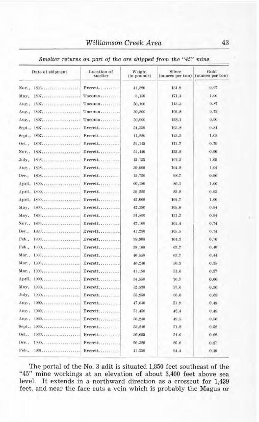
Williamson Creek Area 43
Smelter returns on part of the ore shipped from the " 45" mine
DnLo or shipmen t Location or smelter
\r cigh I Silver Gold ( iu pounds) (ount-es J)cr ton) (ounces per t on)
Nov.. 1800........ .• . . . . . . . . . . Everett . . ... . ..• ..
i\luy, ]807 . ... 'racomn . .... .... .
.\lJ!f, , lbY7 . ... rruccunn . ..... •• ..
.\ug. , 1 or . ... .. ........... . .. 'l'ncomo .... ..... .
.\ui,., 1 97 ................ .. .. 'l'acomu ....... • ..
Sept., 1Sl17 .................... Everett .. ...... . ..
:scr,t., 1~7. .... . ... . ... ..... .. .Evcretc ....... ... .
Oct., 1-SW . ....... . .... . , .. ... E verett ..... ... . ..
Nov., 18:>7 .......... ....... . .. Everet~ .. .
July, 1S9 .. . . . . .. . .. .. .. . . . . . Everett .. .
Aug.. 15\)c ............. ....... Everett .. . . ...... .
0('C., IS'OS...... .. . .... . ... ... Everett ....... ... .
April , JS!f.>...... .............. Everett ......... ..
.\pnl . lll!/9.. ............... .. . Everett ... . ..... ..
April, 1899.................... Everett ... . ...... .
:\las, 1100 ... . E,-re.rctt ......... . .
11ny, lal9 . ... Everett ... .. ..... .
~o,· .. 151)9... . . .. . . .. .. .. • .. .. Everett .......... .
0(.'C., 1899................ . ... Everett .. . . .. . .. . .
l·'ch.. 1900... ..... . ........... Everett .. ........ .
Pel,., 1000.. ...... .. .......... Everett .... ..... . .
Mur. 1 11)00 ... .... . F.verdt ... .. .... ..
Ma ,·., 1000 ... .... . .E,·erett .. .
Mor . . 1000 ... ........ ...... . .. Everett .. .
A11rll , IOOO ..... ..... .. . ....... Everett .. .
M11y , IOOO ............. . ...... Everett .... ..... . .
July, 1900. .. ... . . . .. . . . .. .. . . Everett .... ...... .
Aui;. , H)OO . ... Everett .. . ... ... . .
. \ Ut{., 1000 .... E vere tt. ........ ..
,\ ui:,-., moo ... . Evel'f'U ....... .. . .
S..11l. , 1000 . .. . Everett ..... ..... .
Oc•l., moo. ............... .. .. EvcreLt . .. .. .... ..
D~c·. , 11~•1 . .. .. .. .... .... . ... Everett .......... .
Fc•I,. . HlOI....... . .. .. . .. .. . . . Everett . . .... . .. ..
41,&0
8,100
50,11)()
39,800
50,000
5-1,330
·11,220
51,f.l5
51,-140
45, 13.;
31),000
15,720
60,J&.I
3fl,:l'.l0
42,000
42,390
34, ' 00
42,100
H,200
38,900
:t'l, 100
40,r,;;o
~6, 210
41 ,100
M,iy.;o
,:;2,s.~o
0.5,000
,li ,640
51.450
M ,2-lO
:;a,240
ro,Gi"i5
211.320
-11 ,3:,0
134.9
171.4
ll3.3
102.8
128.1
163.8
143.:?i
llJ .7
122.8
101.3
J0,1.8
98.7
SG. l
85.8
101.7
]05.0
]21.2
101.4.
100.5
10!.3
rrr .1
6:1. 7
50.3
5U)
'Til.7
37.6
66.0
51.9
48.4
40. :,
51.8
54.G
81!.6
9-l .4
1.00
0.87
0. 72
0.00
0 .1>4
1.0'l
0 .79
0.00
1.0-;;
1.01
0.00
1.00
0.93
1.00
0.0-I
0.9~
0.71
0.74
0.76
0.40
0.-14
0.3f>
0.37
0.60
0.30
0 .68
0. 49
0.4S
O.i,6
0.GZ
0.62
0.87
0.49
The portal of the No. 3 adit is situated 1,850 feet southeast of the "45" mine workings at an elevation of about 3,400 feet above sea level. It extends in a northward direction as a crosscut for 1,439 feet, and near the face cuts a vein which is probably the Magus or

44 Geology and Ore Deposits of the Sultan Basin
a part of it. A drift then follows the vein about N. 67 W. for 960 feet to a point almost directly beneath the old mine workings. A few crosscuts extend northeast or southwest for short distances from the drift. The drift, for most of its length, appears to be on the hanging wall of the vein, and the mineralization is not well exposed except in the last 260 feet. At about 700 feet, the vein is 20-24 inches thick, gradually thinning toward the face of the drift, where it is 8 inches thick. (See fig. 3.) The mineralization consists of quartz, calcite, and a little ankerite together with sphalerite, arsenopyrite, pyrite, pyrrhotite, chalcopyrite, and galena. A soft silicate mineral, probably talc or serpentine, is also present in small amounts. An assay report of a sample taken from the vein in the No. 3 drift is furnished by The "45" Mines, Inc. The width is not given:
Assay of sample from No. 3 tunnel
re. M. Fassell Co .. analyst]
Zinc (percen t) .. .... . ...... ........ ..... . .. ........ 3.7 Lead (percen t) . . . . . . . . . . . . . . . . . . . . . . . . . . . . . . . . . . . . 6.5 Arsenous oxide (As,0 ., ) (percent) .. .. . .... . ......... 18. 5 S ilver (ounces per ton)..... . . . ..... . . .. . . . . . ... . .. . 8 . 0 Gold ( ounces per ton ) . . . . . . . . . . . . . . . . . . . . . . . . . . . . . . . O . 28
It is possible that the complete vein system on the No. 3 level has not been disclosed by the present workings. None of the crosscuts entering the northeast wall of the drift is longer than 15 feet, and, considering the branched condition of the vein in the mine workings some 800 feet above, it would appear practical to explore the ground northeast of the drift for several more feet in order to determine whether or not other parallel veins or branch veins exist.
Two tunnels on the Due Pree and the Hard to Beat claims are southeast of the "45" mine workings nearly at the same altitude. The position and structure of the vein at each of these places suggests that the workings are on a southeastern extension of the Magus vein. The Deu Pree tunnel is in a steep gully about 1,600 feet southeast of the portal of the No. 2 tunnel. It enters the hillside at one side of the vein, then curves and intersects it at 45 feet. A drift continues to 117 feet from the portal and exposes a 3- to 4-foot vein consisting of crushed argillite and gouge carrying quartz, calcite, sphalerite, arsenopyrite, pyrrhotite, pyrite, chalcopyrite, and galena. Lenses of these sulphides 2-6 inches thick occur in places. Some marcasite and a small amount of scheelite are also present, and a polished section of a sample of the vein shows a few t iny veinlets of a reddish-colored, submetallic mineral that may be ruby silver. Near the portal of the tunnel a complete section of the vein is exposed in the floor of the gully, as follows:

Williamson Creek Area 45
Section of t he vetn at the Dett Pree tunneL
Material Thickness in Inches
Argillite waIJ ............................................... . Gouge containi11g arsenopyrite and pyrite ........... ... ...... .. . Quai-tz with pyrite, pyrrhotite, sphalerite, and chalcopyrite ...... . Gouge containing a l ittle arsenopyrite .......................... . Quartz and calcite together with pyrite, pyrrhotite, sphalerite,
galena, :irsenopyrite, and chalcopyrite ...................... . Crushed argil lite and gouge ... . .. . ............................ . Quartz containing considerable pyrite, pyrrhotite, sphalerite,
galena, and chak:opyrite .......... . .. ............. .. ....... . Brecciated quartz, leached ........................ . .. ....... .. . Argillite wall containing many calcite veinlets .. . ... . .... .. ..... .
Total vein ........ . ............ . ...... . ..... . ... .. . . .... .
4
5 9
3 6
5 12
44
The Hard to Beat working is about 1,100 feet southeast of the Deu Pree tunnel, and is a drift extending S. 65° E. for 210 feet along the vein. The mineralization is similar to that at the Deu Pree. A dike, however, cuts the vein at an acute angle and reduces the thickness of the vein in the drift from 41/2 feet at the portal to about 6 inches at the face. West of the portal, the vein is exposed on the surface for a length of more than 100 feet and to a thickness of 2-4 feet. An assay of a sample of unknown width from the Hard to Beat tunnel is furnished by the owners:
Assay of a saniple from the Hard to Beat ltmnel re. l\l . Fassett Co .. analyst]
Zinc (percent) . . . . . . . . . . . . . . . . . . . . . . . . . . . . . . . . . . . . . 4.3 Lead (percent) . . . .. . . . . . . . . . . . . . . . . . .. .. . . . . .. . . . . . 4. 6 Arsenous oxide (As,0 .;) (percent ).... . .............. 6.2 Silver (ow1ces per ton) . .............. . ... .. ... .... .. 10.4 Gold ( ounces per ton).. . . . . . . . . . . . . . . . . . . . . . . . . . . . . . O. 6
No other workings are known to be on the Magus vein. A 20-foot adit, No. 4 tunnel, is said to be 200 feet below the No. 3 tunnel, but it was not found. Another tunnel, No. 5, enters the hillside about 600 feet south of the "45" camp; this was caved at the portal in 1943, but is reported to be 150 feet in length.
An undeveloped vein is exposed on the "45" No. 7 claim about 1,000 feet south of the "45" camp. It is at an elevation of about 2,100 feet on the east bank of Williamson Creek, about 200 feet above the mouth of the unnamed stream that drains Copper Lake. The mineralization occurs in a 10-foot shear zone in quartzitic argillite, and consists of quartz and considerable pyrrhotite and arsenopyrite and smaller amounts of sphalerite, pyrite, chalcopyrite, galena and calcite. A very small amount of scheelite was found. A cross-section of t he exposure shows:

46 Geology and Ore Deposits of the Sultan Basin
Section of the vein-exposure on the " 45" No. 7 claim
Materi al
Wall ( ?) . .. .... .... .. ... .... ... . .. . ......................... . Fracture zone containing quartz, arsenopyrite, pyi-ite, sphalerite,
galena, a nd chalcopyrite . . .......... . .... .. . ....... ... ..... . Gouge zone containing stringers 2-4 inches thick of qua rtz, arseno-
pyrite, pyrrhotite, and sphalerite ................ . .......... . Fracture zone containing quartz, arsenopyrite, pyrrhotite, sphale-
rite, pyrite, galer.a, and a little chalcopyrite ............. . Wall (? ) quartzitic argillite ........ . . .... . .. ...... ..... . ..... . .
Thickness i n inches
54
42
24
The strike of this vein is in doubt. It dips steeply and appears to trend eastward, but it cannot be traced beyond the bank of the stream because of overburden and thick brush.
M ILWAU K EI-: PROSPECT
The Milwaukee group includes eight unpatented claims named Milwaukee Nos. 1 to 8. They lie in the SE% sec. 32, (30-lOE) and adjoin the southeastern part of the "45" group of claims. (See fig. 2.) A steep trail which leads from Williamson Creek to Copper Lake crosses the property. The claims were staked in 1940 and 1941 by Forrest E. Wing and associates of Tacoma. Part of the property is reported to have been the old Columbus prospect, but, until the present owners located it, no work had been done for many years.
Two veins on the property are known, and others may be found as prospecting continues. One is on the Milwaukee No. 4 claim, and the other, on the Milwaukee No. 5. They both occur on the precipitous north wall of the canyon of the stream draining Copper Lake, and are about halfway between the lake and Williamson Creek. The Milwaukee No. 4 vein is the lower in elevation and is exposed by a small open-cut at an altitude of about 2,750 feet. It is a quartz vein, 10-12 inches thick, that occurs in quartzitic argillite. The strike is N. 80° E. and dip, nearly vertical. The quartz contains arsenopyrite, pyrite, sphalerite, and a small amount of chalcopyrite. The vein can be traced on the steep surface for about 50 feet from the open-cut; beyond, it is covered by overburden and thick brush.
The Milwaukee No. 5 vein occurs about 700 feet southeast of the No. 4 vein at an altitude of about 2,950 feet. It is a vein of quartz 6-24 inches thick containing sphalerite, arsenopyrite, pyrite, galena, and a small amount of chalcopyrite. Comb structure in the quartz is well developed. The vein strikes N. 35° W. and dips 40°-45° SW. in argillite and quartzite. It is exposed on the surface for a length of about 150 feet , trending up the steep hillside from near the bottom of the canyon. Near its lowest exposure, the vein is followed by a drift for 25 feet, and about 125 feet northwest of this working

Williamson Creek Area 47
an open-cut has been made. The vein probably continues northwest but is covered by a mantle of soil. The owners report that an assay of a sample from the vein showed 10 percent zinc and 5 percent lead as well as values in gold and silver.
SILVER HORSESHOE PR()SP ECT
The Silver Horseshoe group, just east of the Milwaukee group, consists of 10 claims named Silver Horseshoe Nos. 1 to 10. They lie north of Copper Lake on the steep south slope of Big Four Mountain, in the SW1.4 sec. 33, (30-lOE). (See fig. 2.) The claims were staked in 1940 by For rest E. Wing and associates of Tacoma and are held by annual assessment work. A steep trail about a mile in length which leads to Copper Lake from the "45" mine trail on Williamson Creek, gives access to the southwestern edge of the property.
The group lies across a contact between argillitic and quartzitic phases of the old metamorphic series on the north and intrusive quartz diorite to the south, and several mineralized fracture zones occur in the quartz diorite. On the Silver Horseshoe No. 3 claim, these consist of nonpersistent fractures that trend in various directions and contain fillings of quartz, arsenopyrite, pyrite, chalcopyrite, sphalerite, galena, and, rarely, molybdenite. They range in thickness from a knife-blade to 2 or 3 inches and are at most places widely spaced. At the discovery cut of the claim, several of these veinlets converge and form a small lens of quartz and sulphides 4-12 inches thick.
The mineral deposit of the Silver Horseshoe No. 1 claim is in a steep, narrow gully about half a mile northeast of Copper Lake at altitudes between 4,500 and 4,800 feet. The gully follows a fault zone that strikes N. 80°-82° E. and dips almost vertically and which is exposed on the floor and walls of the gully for a distance of about 300 feet. The wall rock is quartz diorite. The center of the fault zone is a 6- to 24-inch gouge seam which contains a few lenticular masses of quartz and calcite and a small amount of arsenopyrite and chalcopyrite. Branching from the fault zone are a great many side fractures that are apparently tension cracks. (See fig. 4.) These strike N. 10°-30° E. and dip 55°-65° SE. and contain considerable quartz, sphalerite, pyrite, chalcopyrite, galena, arsenopyrite, and pyrrhotite. A small amount of scheelite is also present. These veins range from a knife-blade thickness to 4 or 5 inches, and extend into the walls of the fault zone for variable distances; most of them pinch out within 5 or 6 feet, but a few extend for 30 or more feet. In most places along the exposed zone of mineralization, several feet of quartz diorite separate the veinlets; but at one place, where more intense fracturing occurs, the mineralized cracks are closely spaced, and, in an area about 5 feet wide and 6 or 7 feet long, they lace through the country rock and constitute about 50 percent of

48 Geology and Ore Deposit:s of the Sultan Basin
the mass. It is estimated that th is zone would assay about 1 to 2 percent copper, 4 to 5 percent zinc, and 3 to 4 percent lead. Assays of three samples of this mineralization, reported by Mr. Wing, indicate a fairly high content of silver.
Lead
Gold
Silver
A ssays of vein m aterictl f r om Silver Horseshoe N o . . 1.
I Analyst not k nown]
Sample A
(percent) ........ . .. ... ... .. .... ... 3.60
(ounce per ton ) .... . . . ..... ....... . 0.04
(ounce per ton) .. .... . ..... . .... . . 4.80
Sample B
l Q.40
0.36
142.10
Sample C
11 .30
0.42
160.80
Just above the exposure of the mineralized zone, the quartz diorite is in contact with quartzite of the old metamorphic series. Erosion has not been so effective on this more resistant formation as on the quartz diorite; so the slope gradient is less above the contact than below. As a result, talus and soil obscure this area, and it is
F1cuRE 4-Idealized s ketch of the Silver Horseshoe No. 1 vein.

Williamson Creek Area 49
not known whether or not the mineralization persists into the quartzite.
The structure and mineralization of the Silver Horseshoe No. 1 deposit affords evidence bearing on the manner of its formation. The stresses that produced movement along what is now the gouge seam also, apparently, opened the tension cracks that extend out into the walls of the zone for variable distances. This fault zone later became a course for hot mineralizing solutions emanating from magma at depth. The main fracture, however, did not become the principal locus for the mineralization, most of the sulphides being deposited in the tension cracks instead. Probably the small tension cracks in the walls were at a lower temperature than the larger seam, therefore offering better precipitating conditions. The Silver Horseshoe No. 1 deposit appears typical of several veins in the Sultan Basin that are enclosed in quartz diorite.
LTT'f L F. CHLEP PROSP ECT
The Little Chief property consists of seven patented claims and two millsites lying in sec. 5, (29-l OE) , partly on the steep slopes of Little Chief Peak. (See fig. 2.) A small cabin is on the property near the Williamson Creek trail, about 41/2 miles from the Sultan Basin road. Part of the claims were staked in 1891 by Archie Williamson and A. Gordon, and shortly after were acquired and patented by an organization known as the Stilaguamish and Sultan Mining Co. In 1943 the property was held by the Sykes estate, of which the Continental Illinois National Bank and Trust Co. of Chicago is trustee.
l 0 50 100 200FT.
FrcuR£ 5-Sketch of workings at the LilUe Chief prospect.

50 Geology and Ore Deposits of the Sultan Basin
Two tunnels, the only ones found, are on the Little Chief claim in a steep, partly snow-filled canyon on the west side of Little Chief Peak. (See fig. 5.) One is at an altitude of about 3,000 feet, and the other, 800 feet farther east, is about 700 feet higher. Both are in the northeast wall of the canyon. The lower tunnel extends for about 410 feet eastward. No veins are intersected, and the only mineralization is a small amount of iron sulphide in argillitic and quartzitic phases of the old metamorphic series. An 8-foot limestone bed is cut 210 feet from the portal. The tunnel was apparently driven in an effort to explore, at depth , a mineral-showing that crops out near the upper tunnel. The upper tunnel extends east for 30 feet, then branches, one branch trending southeast for about 45 feet , and the other, north for 30 feet, then east for 40 feet. The first part of the tunnel cuts two fracture zones, 2-4 inches thick, which contain a small amount of quartz, calcite, chalcopyrite, arsenopyrite, and pyrrhotite. Smaller fractures containing sulphides occur in the easterly trending branch, and copper carbonate stains show at several places. The wall rock is quartzite and conglomerate. On the surface near the portal, several patches of chalcopyrite and other sulphides are exposed on the face of a cliff over an area of several square feet. This occurrence is due to erosion along one wall of a narrow vein, leaving part of the other wall intact and with thin patches of sulphides clinging to it. The wall is brecciated in places and contains lenses of matted amphibole crystals together with calcite and chalcopyrite. The vein strikes northeast and dips vertically. About 100 feet along its strike from the portal, where both walls of the vein are exposed, it is 3-5 inches thick. What appears to be a similar vein occurs on an inaccessible cliff about 90 feet above and northeast of the portal. The face of the cliff is heavily stained by copper carbonate. Cobalt and nickel have, for several years, been reported to occur at the Little Chief prospect. A trace of nickel was found in some specimens, but no cobalt was detected.
ALPHA AND BETA PLACER CLAlMS
The Alpha and Beta placer claims, on Williamson Creek just south of the "45" property (see fig. 2) , are patented and owned by the Sykes estate. The claims are contiguous and cover an area of bottom land below the steep slopes at the head of Williamson Creek. The alluvium on the property is principally sand, gravel, and large boulders of schist and quartz diorite that have been carried down the slopes by streams and snowslides. No pits or other diggings were found on the property, and apparently no work has been done for many years.
ALA-DICK SON PROSPECT
The Ala-Dickson property of two unpatented claims is held by John H. and Robert J. Dickson of Tacoma. It is in the NE% sec.
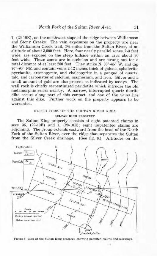
North Fork of the Sultan River Area 51
7, (29-lOE) , on the northwest slope of the ridge between Williamson and Stony Creeks. The vein exposures on the property are near the Williamson Creek trail, 3% miles from the Sultan River, at an altitude of about 3,000 feet. Here, four nearly parallel zones, 2-3 feet wide, are exposed on the steep hillside within an area about 90 feet wide. These zones are in eschelon and are strung out for a total distance of at least 200 feet. They strike N. 30°-45° W. and dip 70°-90° NE. and contain veins 2-12 inches thick of galena, sphalerite, pyrrhotite, arsenopyrite, and chalcopyrite in a gangue of quartz, talc, and carbonates of calcium, magnesium, and iron. Silver and a small amount of gold are also present as indicated by assays. The wall rock is chiefly serpentinized peridotite which intrudes the old metamorphic series nearby. A narrow, interrupted quartz diorite dike occurs along part of this contact, and one of the veins lies against this dike. Further work on the property appears to be warranted.
NORTH FORK OF THE SULTAN RIVER AREA
SULTAN KING PROSPECT
The Sultan King property consists of eight patented claims in secs. 36, (29-lOE) and 1, (28-lOE); eight unpatented claims are adjoining. The group extends eastward from the head of the North Fork of the Sultan River, over the ridge that separates the Sultan from the Silver Creek drainage. (See fig. 6.) Altitudes on the
E xplonation
Seo le
Contour intcrvoJ 500 faol
Dcrtum mcon ,co level
N
F:rcuRE 6-Map of the Sultan King prospect, showing patented claims and workings.
I 6

52 Geology and Ore Deposits of the Sultcin Basin
property range from 3,300 feet on each side of this divide to more than 5,000 feet on Crested Buttes and other high points on the ridge. The prospect is reached by a 3-mile trail that extends from the end of the Sultan Basin road; another old trail is reported to reach the property from the Silver Creek road, which is about 1 mile to the east.
The Sultan King prospect was formerly known as the Sultan Queen, and was recorded under that name in 1892 by George E. Farrell. Since then, it has also been known as the Sultan group (or mine) and the Hicks property. The present owner is the Sultan King Mining Co., Seattle, of which Frank Goodwin is president and Richard Desimone is secretary-treasurer. Several hundred feet of underground work was done on the property prior to 1926; and in 1920, 24 tons of ore, reportedly valued at $42.00 per ton, were shipped to the Tacoma Smelter. No buildings are now standing on the property.
The predominant rocks at the Sultan King are quartz diorite and the overlying intruded conglomerate-argillite series. The contact zone between these rocks is well exposed in thls area; in many places it consists of a breccia containing considerable specular hematite and pyrite together with a small amount of pyrrhotite and chalcopyrite. The oxidation of these minerals has resulted in the stain of iron oxide that characterizes many of the outcrops here. Several veins, from a fraction of an inch to more than 3 feet in thickness, cut through the country rock and contact zone; they trend in various directions from N. 70° E. to S. 65° E. and dip steeply southward. Some of these have been explored by six underground workings and by several open-cuts, which are indicated by numbers and letters in figure 6.
The principal vein of the group is one t hat occurs in a steeply dipping fault zone that trends S. 59°-63° E. through both quartz diorite and the conglomerate-argillite series. The vein is exposed on the western side of the Crested Buttes ridge in a steep, narrow gully, in open-cut "c", and also by tunnel Nos. 1, 2, and 3. These indicate a total length for the vein of at least 1,000 feet on the western side of the ridge, and, presumably, it extends farther eastward into the area on the Silver Creek side. The No. 1 tunnel, at an altitude of about 3,800 feet. enters the hillside a short distance to one side of the vein and was driven almost parallel to it for 440 feet before intersecting the vein. It then extends as a drift for 610 feet. Several crosscuts, all from 10 to 20 feet in length except one that is 70 feet , extend to the northeast or southwest from t he drift. (See fig. 7.) These workings have a total length of more than 1,200 feet. The vein, exposed by the drift for at least 535 feet , is from 12 to 72 inches in th ickness and averages about 21.5 inches. Some of the crosscuts expose other smaller veins, 2-6 inches thick, that are roughly parallel to the larger vein. For the first 450 feet in the

North Fork of the Sultan River Area 53
drift the main vein is fairly regular and consists of quartz that contains chalcopyrite, pyrite, and pyrrhotite, together with smaller amounts of molybdenjte and arsenopyrite; gold and silver also are
?L...l......LJ_L...;SILo ____ ,_,?_0 ________ 2_,qo FEET
FIGURE 7. - ASSAY PLAN OF DRIFT
IN NO. I TUNNEL, SULTAN l<ING PROSPECT.
S~MPLED IN 1926 BY P.H. HOLDSWORTH.
WEI GHTED AVERAGES
4 1.2· - 2.09,-,
36"- 1.01•1.
50.5" - 2.73 °/o
44"- 4.38%
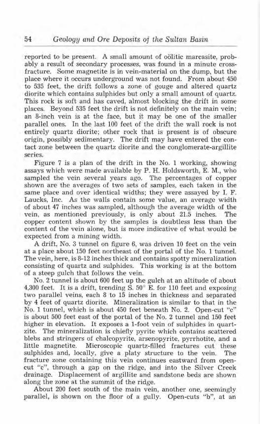
54 Geology and Ore Deposits of the Sultan Basin
reported to be present. A small amount of oolitic marcasite, probably a result of secondary processes, was found in a minute crossfracture. Some magnetite is in vein-material on the dump, but the place where it occurs underground was not found. From about 450 to 535 feet, the drift follows a zone of gouge and altered quartz diorite which contains sulphides but only a small amount of quartz. This rock is soft and has caved, almost blocking the drift in some places. Beyond 535 feet the drift is not definitely on the main vein; an 8-inch vein is at the face, but it may be one of the smaller parallel ones. In the last 100 feet of the drift the wall rock is not entirely quartz diorite; other rock that is present is of obscure origin, possibly sedimentary. The drift may have entered the contact zone between the quartz diorite and the conglomerate-argillite series.
Figure 7 is a plan of the drift in the No. 1 working, showing assays which were made available by P. H. Holdsworth, E. M., who sampled the vein several years ago. The percentages of copper shown are the averages of two sets of samples, each taken in the same place and over identical widths; they were assayed by I. F. Laucks, Inc. As the walls contain some value, an average width of about 47 inches was sampled, although the average width of the vein, as mentioned previously, is only about 21.5 inches. The copper content shown by the samples is doubtless less than the content of the vein alone, but is more indicative of what would be expected from a mining width.
A drift, No. 3 tunnel on figure 6, was driven 10 feet on the vein at a place about 150 feet northeast of the portal of the No. 1 tunnel. The vein, here, is 8-12 inches thick and contains spotty mineralization consisting of quartz and sulphides. This working is at the bottom of a steep gulch that follows the vein.
No. 2 tunnel is about 600 feet up the gulch at an altitude of about 4,300 feet. It is a drift, trending S. 50° E. for 110 feet and exposing two parallel veins, each 8 to 15 inches in thickness and separated by 4 feet of quartz diorite. Mineralization is similar to that in the No. 1 tunnel, which is about 450 feet beneath No. 2. Open-cut "c" is about 500 feet east of the portal of the No. 2 tunnel and 150 feet higher in elevation. It exposes a 1-foot vein of sulphides in quartzite. The mineralization is chiefly pyrite which contains scattered blebs and stringers of chalcopyrite, arsenopyrite, pyrrhotite, and a little magnetite. Microscopic quartz-filled fractures cut these sulphides and, locally, give a platy structw·e to the vein. The fracture zone containing this vein continues eastward from opencut "c", through a gap on the ridge, and into the Silver Creek drainage. Displacement of argillite and sandstone beds are shown along the zone at the summit of the ridge.
About 200 feet south of the main vein, another one, seemingly parallel, is shown on the floor of a gully. Open-cuts "b", at an

North Fork of the Sultan Riv er Area 55
altitude of about 4,300 feet, expose this vein in quartz diorite a short distance from the contact with the conglomerate-argillite series. The vein is from 1 to 3 feet thick and consists of quartz with considerable arsenopyrite and lesser amounts of chalcopyrite, pyrite, pyrrhotite, and sphalerite. It is enclosed in a brecciated zone about 5 feet wide that strikes N. 76°-87° W. and dips 80° NE. Open-cut "a", several hundred feet west of "b", may be on an extension of the vein. Here, a 4-foot fracture zone striking eastward is weakly mineralized by quartz and sulphides.
North of tunnel No. 1, several small veins enclosed by quartz diorite have been prospected. Tunnel No. 4, 15 feet long, is about 300 feet northeast of the portal of tunnel No. 1 and 150 feet higher in elevation. It trends S. 61 ° E. on an 18-inch vein which consists of 12 inches of brecciated material and 6 inches of quartz, chalcopyrite, pyrite, and arsenopyrite. The vein is exposed for at least 100 feet farther on the face of a cliff above the portal. No. 5 tunnel, about 450 feet north of No. 4, was driven eastward for 47 feet on a series of mineralized stringers. A winze, 12 feet from the portal, is at least 8 feet deep. Mineralization occurs chiefly in stringers from 3 to 6 inches in thickness that contain a mixture of arsenopyrite, pyrite, chalcopyrite, and specular hematite. Considerable specular hematite also occurs in the surrounding coarse-grained iron-stained quartz diorite. Tunnel No. 6 is about 200 feet north of No. 5 at a slightly lower elevation and follows a fracture zone N. 80° E. for 21 feet. Mineralization, consisting of pyrite, arsenopyrite, some chalcopyrite, and specular hematite, is confined to a 2- to 6-inch zone in the quartz diorite.
FLORENCE RAE MINE
The Florence Rae property, of 14 unpatented claims, is owned by Harry Rudebeck of Everett and is in secs. 26 and 27, (29-lOE) , on the rugged eastern slope of Red Mountain. (See fig. 8.) The end of the Sultan Basin road is at the eastern edge of the property near the North Fork of the Sultan River, and trails lead up the hillside to several veins and workings. One cabin is at the end of the road at an altitude of 2,500 feet, and two others are about a third of a mile west at an altitude of about 3,500 feet. A two-cable gravityoperated tramway, about 4,500 feet long, connects a bunker on the road with the Florence Rae mine, at an altitude of 4,450 feet. During the periods 1918-19 and 1938-41 the mine produced a total of 606.11 tons of crude ore which was shipped to the Tacoma Smelter. Based on smelter returns, this ore averaged about 12.6 percent copper and 4.22 ounces of silver per ton together with a small amount of gold. The claims of the group were staked during the years 1908-11 by George Moshier, Frank Curtiss, William Stotreon and others, and they were acquired a short time later by Nicholas Rudebeck. Since then , the property has been held by the Rudebeck

56 Geology and Ore Deposits of the Sultan Basin
, P OL AR I
\
/
\
N
[ )( !"I. AN A 1 10 N
}.AT( 0 !'( $
(O"lfOUlf tN l(f!V4 L !JOOrHf
Cl.ltt,Jv s, ,ilO~IIOll! t,1 ll ff1,.r S(A L(vtl.
\
f lGURE 8 - GEOI.OGIC SK ETCH OF RED MOUNTAIN AREA SHOWING MINING Cl.AIMS.
• ;',,JI
>' \ ..
1
I
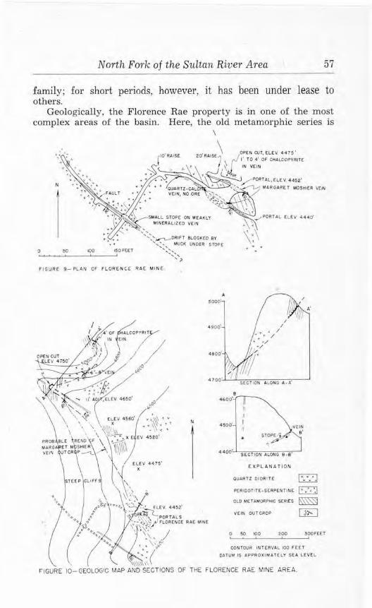
North Fork of the Sultan River Area 57
family; for short periods, however, it has been under lease to others.
Geologically, the Florence Rae property is in one of the most complex areas of the basin. Here, the old metamorphic series is
\
N
0 50 ,00
' ' ' '
,o· RAISE io'RAtSE \ OPEN CUT, ELEV 44 75 • r 7 \t I' TO • ' OF CHALCOPYRITE IN VE IN .
• ~/PORTAL,flEV, 4452'
• OUARTl -CA~ ~>~ MARGARET MOSHiER \IEIN V(IN, NO ORE ~°';..':_,_
"::.~:,~ SMALL STOP£ ON WEAKLY
MIN(RAUZ£0 V(IN
',:,.,.....,_.DRIFT Bt.OCl<EO BY ',~ .. , .VUCK UNDER STOP£
',~~ ...... '?
FIGURE 9-PLAN OF FLOR ENCE RAE MI NE
N
•600·
450o'
4400'
II rt
' "
SECTION ALONG 8-e•
EXPLANATION
OUARTl 010Rtl£
PERtOOllTE-SrRPENTINE
OLD M[TAM0RPl11C SERtES
VEIN OUT CRO?
0 50 IOO WO
ID >
IA/<:, ~ GE]
300FEET
CONTOUR IN TERVAL IOO FEET
DAlUt.! IS APPROXI MATELY SEA LEVEL

58 Geology and Ore Deposits of the Sultan Basin
intruded by peridotite, and both of these rocks have been intruded by a quartz diorite mass and several dikes. Faulting in these rocks has complicated the structure. Mineralization is of two forms: veins that occupy fault zones, and small chromite bodies that occur in the peridotite.
The Florence Rae mine is on the Margaret Moshier vein (see figs. 9 and 10) , at the head of a talus slope at the base of cliffs on Red Mountain. The vein strikes N. 58°-62° W. and dips 35°-50° SW. Two drifts, one 12 feet in elevation above the other, have been driven on the vein and are connected by a stope. The ore body is a lenticular or pod-shaped mass that occurs in the vein as an ore shoot. It consists of chalcopyrite, pyrite, pyrrhotite, sphalerite, magnetite, and a little galena, together with quartz, amphibole. calcite, and some serpentine. Assays show that a very small amount of nickel-less than 0.25 percent- also occurs in the ore. The ore body was at least 4 feet thick where mined in the center of the stope, but it thins to 3 inches or less toward the northeast, as indicated along the edges of the stope and in the drifts. The upper drift follows the vein for about 70 feet. It is on the footwall, and a raise driven northeast from a place near the face of the drift is probably 3 or 4 feet under the vein. An open-cut, 25 feet above this drift, shows nearly massive chalcopyrite from 1 to 4 feet in thickness, indicating that the ore shoot persists upward to the surface. The lower level follows the vein for 175 feet, then turns southwest away from it. From 55 to 105 feet, it contained the lens of ore which was stoped northward for about 40 feet up to the other drift. It was also stoped to the south, but in 1943 this section of the vein was covered by waste and could not be observed. At the place where the lower level turns southwest, the Margaret Moshier vein is a 4-foot zone of calcite together with some quartz and a small amount of sulphides. Here, it is so weakly mineralized, compared to the section of the vein that was stoped, that it may not have been recognized as the vein and, therefore, not followed. The lower level continues southwestward as a crosscut through quartzite, serpentine, and quartz diorite to a place 364 feet from the portal. At 205 feet it intersected a fracture zone, and drifts were driven northwest for 16 feet and southeast for 9 feet. At 315 feet from the portal the crosscut intersects a fault zone that is weakly mineralized by quartz, pyrrhotite, pyrite, and chalcopyrite. A small amount of stoping was done on this vein, but the owner reports that it was too low in grade to be mined profitably. A drift follows this fault northwestward for 170 feet through serpen tinized peridotite, and another drift, blocked at the collar by broken rock from the stope, extends southeast for a reported distance of about 165 feet. This weakly mineralized zone occurs on the surface about 150 feet south of the portal of the lower tunnel.
North Fork of the Sultan River Area 59
From the Florence Rae mine, the Margaret Moshier vein apparently continues northwestward for several hundred feet, as shown in figure 10, but, owing to inaccessible cliffs, it cannot be traced on the surface for the entire distance. From 550 to 800 feet northwest of the mine, a vein crops out on the surface. It is in line with the trend of the Margaret Moshier vein, agrees with it in strike and dip, and is believed to be the extension of it. In a steep gully, locally called Copper Knob Canyon, an open-cut at an altitude of about 4,750 feet exposes several narrow stringers and lenses of chalcopyrite together with some sphalerite, galena, and specular hematite. The enclosing rock is highly altered, owing to contact metamorphism effected by a nearby quartz diorite dike; and probably the specular hematite, which has an unusual association, is a contact-metamorphic mineral. According to Mr. Rudebeck, this exposure is the remains of a larger lenticular mass of sulphides that has been mined out. Northward from here, the vein can be traced up and along the face of a cliff through metamorphic rocks and quartz diorite. It is 1-8 inches thick for about 200 feet, then abruptly attains a thickness of about 4 feet and, there, is nearly massive chalcopyrite. The vein extends farther north on an inaccessible cliff and is marked by prominent blue and green copper staining.
The gully known as Copper Knob Canyon follows a southeastward-trending zone of fracturing which crosses the Margaret Moshier vein. Some brecciation occurs, and a small amount of mineralization consists of calcite, quartz, and minor sulphides. An 11-foot tunnel driven at one side of the gully shows no mineralization.
The Lambert vein system is exposed on the surface about 1,500 feet south of the Florence Rae mine, and consists of small, irregularly spaced veins in a fault zone. This fault strikes N. 55°-65° W., dips 75°-90° NE., and is marked by gullies on each side of Red Mountain. Below an altitude of about 4,800 feet, on the eastern side of the mountain, the zone is enclosed by quartz diorite, but at higher elevations the wall rock is the old metamorphic series. Mineralization was observed between 4,500 and 4,700 feet, where it can be traced on the surface for about 400 feet . The veins are from 1 to 11 inches in thickness and contain chalcopyrite, pyrrhotite, and magnetite, together with amphibole, serpentine, and some quartz. At the crest of the mountain, at an altitude of about 5,400 feet, the fault zone includes about 6 inches of gouge, 8 inches of mineralized breccia, and 4 inches of nearly massive chalcopyrite. Northwestward from here, down toward Elk Creek, the zone is marked by a snow-filled gully.
The Copper King vein occurs about 1,500 feet northeast of the Florence Rae mine. It is well exposed in a breccia zone for about 30 feet near the northwest corner of the Junie Lode No. 2 claim, at an altitude of about 3,700 feet, and its trend above and north-

60 Geology and Ore Deposits of t,he Sultan Basin
westward from this place is marked by a gully. The vein strikes N. 34°-58° W., dips nearly vertically, and consists of 1-2 feet of quartz, pyrite, arsenopyrite, and chalcopyrite. About 500 feet northwest of the 30-foot exposw·e, a branch fault zone about 4 feet wide trends S. 30° E. and also is marked by a gully. The southwest wall of the fault is heavily serpentinized and contains seams of tremolite as much as 7 inches thick.
Magmatic segregations of chromite crop out in an area of peridotite southwest of the Copper King vein , but no prospect work has been done on them. They occur as irregular masses that are generally only a few inches thick, but one lens was found that measured about 4 by 5 feet in cross-section. The bodies consist of fractured crystals of chromite. about 1 millimeter in diameter, embedded in serpentine. In the centers of the lenses, the crystals are thickly disseminated and constitute about 75 or 80 percent of the rock, but toward the edges they are less concentrated. A little pyrrhotite occurs as microscopic specks among the chromite crystals. One specimen of typical chromite-bearing material was assayed by Willis H. Ott of Seattle and found to contain 23.6 percent chromium (Cr) and 16.3 percent iron (Fe). This does not necessarily indicate an unfavorable chromium-iron ratio in the chromite, for the serpentine gangue. which contains some iron , could be eliminated by concentration.
The Junie working is on the Junie Lode No. 1 clain1, approximately 1,000 feet west of the end of the Sultan Basin road , at an altitude of about 2,600 feet. A drift was driven S. 65° W. for 170 feet on a vein that ranges from a fraction of an inch to 4 inches in thickness. The wall rock is quartz diorite, and the mineralization consists of chalcopyrite, together with amphibole, and a little quartz and scheelite. The vein can be traced for about 300 feet southwestward in a shallow gully above the tunnel.
DORIS l'ROS P F:C'l'
The Doris property, consisting of five unpatented claims, is in secs. 34 and 35, (29-lOE), on the east slope of Red Mountain, south of the Florence Rae claims. (See fig. 8.) The property was first staked in the early 90's, and for several years was known as the Blackman and Brown claims. During the last 40 years it has had several owners; the present ones are reported to be Kelly Summerfield and others of Sultan, Wash. Two veins are on the property. One occurs on the banks of the North Fork of the Sultan River at an altitude of about 3,000 feet, and the other is on the mountain slope some 1,500 feet west and at 3,700 feet altitude. They are reached from the end of the Sultan Basin road by 1 mile of trail that follows up the North Fork of the Sultan River to a place near the lower vein, then leads up the mountain slope to the other.
The upper vein is explored by a drift that trends westward for

North Fork of the Sul.tan River Area 61 -------------------------·--
N
OUARTZI TE AND SCHIST
0 50 100 150 FT. ._.__._....._,,_..._ _ __ _,_ __ __.
~-IN. VEIN
SHAFT L
<._,a-To~o-1N. VEIN
\ I / /
-. PORTAL OF \. LOWER TUNNEL
ELEV. 3600tFT
TALUS
PORTAL OF UPPER TUNNEL
ELEV. 3700 ±FT.
FrcuRE 11-Sketch o! workings at the Doris prospect.
250 feet and follows a nearly vertical mineralized fault zone 1-4 feet wide which cuts through quartzitic and hornfelsic phases of the old metamorphic series. (See fig. 11.) Two narrow aplite dikes crop out a few feet above the portal. In the drift, at 57 feet from the portal, a shaft, now full of water, has been sunk to a reported depth of 40 feet. The first 100 feet of the drift exposes chalcopyrite, pyrite, and a little sphalerite that occur intermixed with breccia and also as irregularly spaced lenticular masses 6-30 inches thick. In some places, especially near the portal, narrow branch fractures leading out into the walls are also well mineralized by sulphides. The entire vein contains an unusually small amount of quartz. Considerable malachite and some chrysocolla and bornite occur at places in the vein, and malachite stains the walls of the drift near the portal. Beyond 100 feet, the vein thins and varies in thickness from 1 to 12 inches. A crosscut 30 feet back from the face cuts three small parallel fractures 6 inches apart, and chalcopyrite together with pyrite, sphalerite, and quartz occurs between two of them. From a place on the surface about 225 feet north of the portal of the drift and 100 feet lower in elevation, a crosscut was driven southward in quartzite for about 200 feet but does not reach the vein. It cuts two narrow dikes that are probably offshoots of a large mass of quartz diorite that crops out about 200 feet lower on the hillside.
The lower vein is developed by two 6-foot drifts, driven into opposite banks of the river. and a shaft 10-15 feet deep at one of the

62 Geology and Ore Deposits of the Sultan Basin
portals. The drifts are on a shear zone striking N. 34° E. and dipping 70° NE. through quartz diorite. Only a small amount of mineralization is shown in them, but the dump of the shaft contains large blocks of nearly massive chalcopyrite, indicating that a vein at least 11 inches thick is in this working. Quartz and a small amount of scheelite are associated with the chalcopyrite. Brush and soil prevent observation of the vein beyond the banks of the river.
SUL'fAN BASl!, MINING CO.
The Sultan Basin Mining Co., of Sultan, Wash., headed by George Startup, president, and George Heald, secretary, holds a group of 14 unpatented claims and fractions in the northern part of sec. 27, (29-lOE). (See fig. 8. ) These claims extend from the North Fork of the Sultan River southwest across the summit of the ridge that projects northwestward from Red Mountain. The North Fork truck road crosses the lower part of the property, and trails extend up the ridge to three groups of workings on different claims. Part of the ground was originally staked by George S. Moshier in 1901. After a short period of development by a concern known as the North Coast Copper Co., the property became idle until 1914 when Moshier, William Stotreon, Frank Curtiss, and others formed the Iowa Mining Co., and, in 1915, produced 104 tons of copper ore of excellent grade. In 1930 the present company was organized and since that time has staked new claims, done exploratory work on the Calumet claim, and shipped about 96 tons of ore from the old Iowa mine.
The old Iowa mine camp, consisting of two cabins, is situated on the road near the river. Equipment on the property in 1944 included a diesel engine belted to a small compressor, pipe lines, track, muck cars, and a few tools for small-scale mining. A 1,300-foot two-cable gravity-operated tramway connects the old Iowa workings with a bunker near the mine camp, and another single-cable tramway extends up the hill about 2,000 feet from the old Iowa to the Calumet workings. The group of claims lies across a contact of the old metamorphic series and intrusive quartz diorite; this roughly follows the contour of the mountainside between elevations of about 2,600 and 2,900 feet above sea level. The metamorphic series is cut by several other intrusives which include the peridotiteserpentine zone and also dikes that are offshoots from the quartz diorite batholith. Several veins fill fractures in these rocks, and three of them on the property have been developed to some extent by the three groups of underground and surface workings: the Jerry Chatman drift in the Mint No. 3 claim, the old Iowa workings on the Mint and Mint No. 1 claims, and the Calumet workings on the Calumet claim.
The Jerry Chatman drift is about half a mile northwest of the Iowa camp and was driven many years ago on an irregular vein in

N
1 QUAR T Z °olORITE
A/ . . • c.o.f'l'J0'' . ' .... . •.
. ,• ' ,<IS¢()
. t<~ {>.~/
na.,.,-ow .....
~
~-->-L-PORTAL - -,, No.2/evel VftNS "\~ -
PORTAL~\::: No. 3 level flev 28,5'±
GENERALIZED SECTION A- B
tlev.2850'!
......._______8
4pproximately ~ooo rt. to road ,,.,,f/ev. 2/SO'! ~
I,,,
QUARTZ OIORI TE
FIGURE 12.- PLAN AND SECTION OF OLD IOWA MINE
MINT ANO MINT NO. I CLAIMS
Sulton Basin Mining Co. 0 50 100 l~OFetl
r:2:2:l METAMORPHIC ROC~~
~ QIJARTZ OIORITE . ~VEIN
<: 0 .... ...... .:s" ~ Q ?;"
.S, ...... -;:;" ~
VJ ~
w ::ti <-'· c ~ .... ~ ~ p
O') <:,.j

64 Geology and Ore Deposits of the Sultan Basin
the old metamorphic series. The portal is situated 700 feet in elevation above the valley floor at an altitude of about 2,700 feet, but it is difficul t to find because the trail leading to it is so overgrown with trees and brush that it is practically obliterated. The irregular contact between quartz diorite and metamorphic rock is exposed about 100 feet below the portal. The drift extends S. 83° W. for 172 feet and follows the vein, which dips 75°-90° SW. For the first 125 feet the vein is from 21/2 to 4 feet in thickness, but farther on it thins gradually and is a 3-inch seam at the face. In places, the vein is a narrow zone of brecciated wall-rock containing chalcopyrite, bornite, and, in cracks, copper carbonate. Elsewhere the vein is predominantly quartz showing sulphides as well as a small amount of scheelite. The wall-rock is quartzite containing chlorite and considerable serpentine; this latter may have been introduced from the nearby peridotite-serpentine mass.
The old Iowa workings consist of three levels situated 1,000 to 1,400 feet southwest of the mine camp and 550 to 900 feet in elevation above the valley floor. (See fig. 12.) The two upper levels, Nos. 2 and 3 at altitudes of 2,850 and 2,895 feet , are on a branching vein enclosed by quartz diorite and are only a few feet below the contact between this rock and the intruded metamorphic series. The lowest level, No. 1 at an altitude of about 2,550 feet, was apparently dTiven in an effort to intersect the vein that is exposed in the upper workings. All these workings enter the hillside just south of a steep, narrow gukh that trends eastward from the top of the ridge. The two upper levels extend completely through the shoulder of this gully, and thus each has two portals.
Mineralization in the Yeins consists principally of quartz and chalcopyrite and lesser amounts of calcite, scheelite, powellite, molybdenite, sphalerite, and chlorite. A small amount of bornite and malachite also exists, and gold and silver are present in minor quantities as indicated by assays. The width of the vein is from 3 or 4 inches to at least 24 inches and was possibly as wide as 48 inches in old stopes. The No. 3 level follows a part of the vein N. 64° W. for 210 feet, but is blocked for a short distance by muck that has fallen through broken timbers from an old stope. The No. 2 level, 45 feet lower than No. 3, follows a branch vein N. 79° W. for 155 feet, at which place this branch intersects the vein that is exposed in the drift above. The No. 2 level then continues on this vein N. 66° W. almost directly beneath the No. 3 level for 107 feet, then turns and extends northeast for 25 feet, opening out into the gully 35 feet below the northwest portal of the No. 3 drift. A raise connects these two upper levels, and a vertical shaft extends from the No. 3 level to the surface. Stoping has been done at two places above the No. 3 level and also on each side of the raise below this dTift. It was from these workings that the old Iowa Mining Co. mined and shipped 104 tons of ore which contained approximately

North Fork of the Sultan River Area 65
20 percent copper, 0.223 ounces of gold, and 3.23 ounces of silver per ton, suggesting that a lens of high-grade ore was at the intersection of the two branches of the vein. Remnants of the vein left on the ends of the stope below No. 3 level show an 8-inch streak of n early massive chalcopyrite; probably the mineralization was wider where the principal stoping was done. Other portions of the vein are not so well mineralized, but four small underhand and overhand stopes were made on the branch vein followed by the No. 2 level. The width of the vein, here, is from 14 to 20 inches, and it contains streaks of nearly solid chalcopyrite 3 to 4 inches wide. The production of approximately 96 tons made during the years 1937-41 is reported by the owners to have been mostly from these small stopes. Two smelter returns are available for a part of this ore:
Smelter returns on ore from Sultan Basin M in ing Co., Iowa Mine
D a te Tons Gold Silver Copper (ounces ) (ounces) (p ercent )
Nove m ber . 1937 .... . . . . . . .. ..... 21.7 0.05 2.45 12.55 July. 1940 .. . ... . .. ... . . . . .. .. . . .. 21.0 0,07 3.84 16.81
The main vein extends northwest beyond the portals of the Nos. 2 and 3 levels, and appears to merge with a major fracture zone that is cut by the gully and strikes nearly at right angles to the metamorphic-quartz diorite contact. About 200 feet west of the tunnels this zone enters the rocks of the old metamorphic series and appears to branch. Mineralization follows some of these branches, as indicated by green copper stains on the canyon walls, but none appears to be of minable width. Near the portal of the No. 3 tunnel a lens of quartz and chalcopyrite, 16 to 22 inches t hick, occurs in quartz diorite in the floor of the gully.
The portal of the No. 1 level is about 350 feet northeast and 300 feet in elevation below the southeast portal of the No. 2 level. The tunnel trends about 50 feet westerly, then branches. One branch leads northwest for 35 feet, and the other southwest for 135 feet. The entire working is in strongly jointed quartz diorite, and some joints, notably in the southwest branch, contain thin veinlets of quartz. calcite, and chalcopyrite. If the southwest branch were continued another 125 to 150 feet, it should intersect the vein exposed in the eastern portion of the No. 2 tunnel, providing, of course, that this vein extends another 150 feet eastward and about 300 feet downward.
The third group of workings on the Sultan Basin Mining Co. property is on the Calumet claim, about 0.7 mile west of the Iowa Camp, on the summit of a high ridge at elevations of from 4,600 to 5,000 feet above sea level. This area is best reached by the trail that leads to the Florence Rae mine; then, from a place just below the mine, going northward for a quarter of a mile. Here, a vein in
-3

66 Geology and Ore Deposits of the Sultan Basin
rocks of the old metamorphic series and serpentine extends across the summit of the ridge and has been prospected by one underground and several surface workings. (See fig. 13.) It is, possibly, a northwest extension of the Copper King vein on the Florence Rae property. (See p. 59.)
0 50 100
CONTOUR INTERVAL IOOFEET 0 ~
DATUM APPROXIMATELY SEA LEVE~
VE IN EXPOSURES l~ I ~ SHOWING DIP rn
OPEN CUTS, -I:,-
l~/?2I \0 l~ ~ /;.~, NUMBERS REFER C) C 0 TO TEXT C) ~\ 0\ % ~/
\ \ FrcuRE 13- Skelch of su rface and workings on the Calumet cla im.
Sulta.n Ba sin M.ining Co.
On the Calumet claim, a tunnel was driven southward as a crosscut for 110 feet through a quartz diorite dike, then 60 feet through metamorphic rock to the vein; then as a drift N. 57° W. for 50 feet; then southwest for 30 feet as a crosscut. The vein is in a fracture zone and locally consists of a quartz lens from 6 to 24 inches in thickness, containing irregular masses of chalcopyrite. This lens pinches out near the face of the drift, but the vein, no doubt, continues as indicated on the surface, and further drifting would probably disclose more mineralization. About 150 feet southwest of the portal of the adit and approximately 100 feet in elevation above it, the vein is exposed on the surface. The zone of fracturing is about 12 feet wide, and it contains lenses and veinlets of quartz containing chalcopyrite, pyrrhotite, arsenopyrite, and marcasite. The zone trends about N. 45° W. and dips almost vertically, and continues up to and over the summit of the ridge. About 100 feet above the exposure, the zone splits, and a branch trends westward also over the summit of the ridge. The main zone is exposed again

North Fork of the Sultan River Area 67
west of the summit of the ridge in nine open-cuts that disclose mineralization over a total length of at least 650 feet. The first four open-cuts, numbered 1 to 4 on figure 13, show an irregular siliceous zone, 1-5 feet wide, that contains chalcopyrite, pyrite, pyrrhotite, arsenojyrite, sphalerite, galena, and marcasite. Near open-cut No. 3 the zone apparently branches, for the next five open-cuts show mineralization trending N. 70° W. and dipping 80°-85° SW., approximately parallel to the other branch zone observed on the eastern side of the ridge. No. 7 open-cut is on a zone, at least 17 feet wide, of silicified metamorphic rock containing disseminated chalcopyrite, pyrite, arsenopyrite, and sphalerite. In places this zone is considerably oxidized and leached. Nos. 5, 6, and 8 open-cuts expose parts of this zone. No. 9 open-cut shows an oxidized and somewhat leached zone of undetermined width which is flanked on the north by a hard, siliceous wall containing considerable sulphides. The wall strikes N. 76° W. and dips 87° SW. About 15 feet north of this exposure is another siliceous zone about 3 feet wide which strikes N. 55° E. and dips almost vertically. It contains considerable chalcopyrite, sphalerite, galena, and iron sulphides. Its relation to the main vein is not known, but it may be a part of it.
Several assays of samples taken from these surface cuts were made available by the owners. In some instances neither the working from which the sample was taken nor the width represented is known, but these assays indicate the tenor of some of the mineralization and for that reason are useful. Sample No. 9, a lso included, was a specimen taken by the writers from the well-mineralized north wall of the oxidized zone in open-cut No. 9.
The gold content indicated by several of these assays is interesting, especially No. 6, from the No. 7 open-cut. This sample is
Assays of samples from the Calumet open-ctits
~(). 1>l 11cc t nkcn
I©.......... No. 1 opra-,·u t (?) ... .. .... .
2(D.... .. .. .. No. 1 Op('D·Cllt (?) ......... .
3@ ......... . l\o. 2 OJ)('1H n t (?) ......... .
J@ .. No. 2 OJ)Cll·CUt (?) ... . .... . .
:i® .... . ..... No. :l Oi>ell·Cllt (?) .... . ... . .
f-0).... . .. ... No. i 01x•u-c11 t .. .. . ...... . .
i(D . .. ....... ~O. 0 OJ)<'O·Cll t (?) .. .. ... . ..
'l(l). .. . . . . . . . No . !) OJl<'ll•Clll. ••.• . •••• ••• •
!J@.... .. .... No. o 011cn-r11L ... ... ... . .. .
IO(l) .•• . ••.
"°idtl, Golrl Sih·tr Copper Zinc (inclu·sl loum,·~) (ounct•,) (percen t) (percen t)
16
2 1
10
sn<.-chnr n
00
o.:t'l
o.v; 0.()J,
0.01
0.0:~
J.00
tr
0.1)6
0.111
0.30
1 .21
i.m
2.2;;
1.2:j
4.10
:;.!l:1
1.20
3.00
4.00
0.56
2.00
J.ij()
3.02
l. 0
4 . "O
o.~s 1.04
5.00
6. ~,0
0.10
3.40
, .... ·::~~--Anuly~ts : (D A. T.. Clovrr. Inc. , Sea t tle : © llrit,11111i:i )lin ing & >'nwHinl! Co. , Ltrl.;
'ol Wl!li~ IT. Ot t , Seatue.
68 Geology and Ore Deposits of the Sultan Basin
reported to have been taken from the highly oxidized portion of the vein, where there may have been some enrichment near the surface.
No other exposures of the Calumet vein are known west of the No. 9 open-cut. Another vein occurs about 1,000 feet northwest of the Calumet workings in a steep, narrow gully near the western end of the Silver King claim. On the floor of the gully, quartz stringers from 112 to 1 inch in thickness lace through a 2-foot fractme zone which trends about east. With the quartz is chakopyrite, sphalerite, and a little galena.
Another exposure of a vein containing nearly massive chalcopyrite is reported to occur about 2,500 feet north of the Calumet workings on the Polar claim. The terrain of that area is exceedingly rough, and an effort to find the deposit was unsuccessful.
SUN.RISE PROSPECT
The Sunrise property, owned by C. H. Kelly of Monroe, Wash., is a group of four unpatented claims which l ie across the north line of sec. 15, (29-lOE), near the head of Vesper Creek. A trail leading from the Sultan Basin road through Headlee Pass to the South Fork of the Stilaguamish River crosses the claims about 2 miles from the road. A cabin is on the claims. The property was first recorded in 1897 by F . M. and T . E. Headlee and G. E. Humes, and was later owned by the Sunrise Mining Co. who gave the prospect its name. The present owner acquired the property in 1913.
The mineral deposit is a large mass of quartz-cemented crush breccia which contains, as ore minerals, chalcopyrite and molybdenite. It outcrops at altitudes of 4,400 to nearly 5,000 feet throughout several thousand square feet of a rough, precipitous area. (See fig. 14.) It appears to be a pipe-shaped mass rather than a longitudinal zone, and is traversed by quartz veins that extend beyond the limits of the brecciation. The wall rock is the old metamorphic series consisting, locally, of conglomerate, siltstone, and some quartzite; some of it could best be termed a hornfels. The breccia fragments are also of this material and range in size from an inch to as much as 20 inches in thickness and average 1-2 inches. Their shape is generally tabular, and, although some are slightly rounded, most of them are sharp, angular fragments that lie in groups of more-or-less parallel arrangement. Within a few hundred feet to the northeast, the metamorphic rocks are in contact with quartz diorite.
Vugs in the breccia zone are common and are generally an inch or two in diameter and lined with small quartz crystals. One vug, 2-3 feet in diameter and lined with large quartz crystals, was reported to have been found when driving one of the tunnels. Chalcopyrite, pyrrhotite, molybdenite, and siderite occur irregularly through the brecciated area, and there is a suggestion that most of this mineralization occurred near the edges of the mass. The sul-

4900'
4800'
4 700'
4600'
4500°
4400'
' \
VEIN
OOWNWARO EXTENTION
OF BRECCIA IJN[XPLOREO
ELEV 4300·' • .1..----------------------------~-~
'1,,, '\·-, __ _ TRA,L ... fo THE
SULTAN RIVER
0 100 200 300FEET '--~'-----'---'
SOUTHEAST-NORTHWEST SECTIONS ALONG tlNES A• A' ANO 9.9' DRAWN IN SAM( PLANE
. I . \
•
. ', '
\ \
\ \
FIGURE 14 - SKETCH AND SECT IONS OF THE SUNRISE PROSPECT.
' I ' -
0
( XPlANATION
OUT llHE OF 8RECCfA AREA
VEIN, SHOWING DIP
UNOERGROUNO WORKINGS
OPEN CUT
50 ,oo
CONTOUR INTERVAL SO FEET DATUM IS APPROXIMATELY SEA LEVEL
' ' ' '
200F£ET
\ (TRAIL TO THE \ STILAGUAMISH RIVER

North Fork of the Sultan River Area 69
phides are present in considerable quantity in some places, and samples that might be taken over widths of several feet would probably assay close to 4 percent copper; at other places, however, the mass is nearly barren of sulphides. Further work is desirable to delimit the mineralization. Where present, the sulphides fill the interstices of the breccia. Finely divided molybdenite was the earliest formed, and, in fact, was partly deposited directly on the breccia fragments to be later overlain by quartz. The pyrrhotite and chalcopyrite were deposited chiefly in the quartz-lined vugs, and many irregular masses of chalcopyrite about the size of peas may be found clinging to quartz crystals in cavities. Siderite also occurs as crystals with the quartz, and a trace of nickel was found associated with one specimen of this mineral.
The best exposures of the brecciation are along a northeastwardfacing cliff near the trail. Three open-cuts have been made along this cliff, and three tunnels are driven northwestward into it. (See fig. 14.) The lowest tunnel was driven 45 feet and barely penetrates the breccia. A trail cut just above this working shows wellmineralized breccia which would probably assay 2 to 4 percent copper. The next tunnel, about 50 feet northwest of the lowest one, follows a 3-inch quartz vein for 35 feet through weakly mineralized breccia, and an open-cut about 100 feet northwest of the portal shows similar material. The third and highest tunnel is near the northern side of the breccia area and extends S. 65° W. for 255 feet along a 1- to 2-foot quartz vein that dips 77° NE. and occupies a fault zone in the breccia. A 12-foot raise was driven on this vein at one place, and six crosscuts extend to the northwest or southeast from the drift. Mineralized breccia is exposed in places on the walls of the drift and in the crosscuts, but the vein contains only a small amount of sulphides together with some calcite. Near the face, the vein shows 4-6 inches of massive chalcopyrite for a length of about 6 feet. This vein is exposed on the surface above the drift and can be traced upward for about 200 feet on the steep slope. Another nearly parallel vein is also exposed on the surface about 50 feet to the northeast. For a length of about 150 feet it contains from 6 to 17 inches of nearly massive chalcopyrite and pyrrhotite together with some quartz and a little sericite. Comb structure of the quartz is well developed. One of the crosscuts in the upper tunnel cuts this vein but apparently does not reach the richest part of it. About 400 feet southwest of the portal of this tunnel, a 2-foot quartz vein is exposed on the wall of a gully, and its attitude suggests that it is an extension of one of those at the tunnel. Northeast of the tunnel, a narrow fracture zone containing some mineralization is exposed for several hundTed feet away from the main breccia zone as interrupted outcrops. About 150 feet northwest of the upper tunnel, an open-cut has been made on the northern
70 Geology and Ore Deposits of the Sultan Basin
edge of the breccia-area. Here, the breccia is well mineralized by chalcopyrite and molybdenite.
About 1,000 feet southwest of the Sunrise workings, a steep, narrow canyon trends southward and opens into Vesper Creek several hundred feet below the prospect. At a place along the walls of this canyon, a network of quartz veins, lacing through quartzite, is exposed in a zone 100-200 feet wide. This is well mineralized by chalcopyrite and pyrrhotite, and may represent a southwesterly extension 0£ some of the veins at the prospect.
48-55 (GARNET) PROSPECT
The 48-55 prospect is a single unpatented claim on a deposit of garnet and other minerals in the center of sec. 9, (29-lOE) , at an elevation of about 5,500 feet above sea level. It is held by P. C. Crane of Snohomish, Wash., who staked it in 1937. No trail leads to the property, but it may be reached from the Sunrise prospect by hiking to the summit of Vesper Peak, thence for about a third of a mile northwest along a ridge toward Little Chief Peak; the deposit is about 300 feet southwest of the crest of this ridge. No equipment is on the property, and development work done consists of a few shallow cuts.
The deposit is a lenticular body about 70 feet long and 50 feet wide, made up , principally, of a more-or-less coherent mass of crystals. This lens strikes northwest and dips about 50° SW., and is enclosed by a hornfelsic phase of the old metamorphic series. The foliation of the wall rock also str ikes northwest and dips southwest, but appears to bend around the garnetiferous lens. Within 400 feet to the northeast, a contact between the metamorphic rock and intrusive quartz diorite is well exposed, and near it are a few thin layers of garnet and amphibole. Apparently the 48-55 deposit was originally a limestone lens that has been altered to its present character. The mineralogy is rather unusual but is not uncommon to contact-metamorphic deposits.
Garnet, probably of the variety grossularite (calcium, iron, aluminum silicate), is the most prominent mineral and occurs both massively and as spectacular clusters of intergrown crystals lining cavities. Isolated crystals are rare if not absent. Quartz crystals are intergrown with the garnet and are generally small in size. The largest ones found are about 1 inch thick and 2 or 3 inches long, and are imperfectly formed. A little chalcedony lines the inside of some vugs, and masses of coarsely crystalline calcite are abundant. Other minerals of the deposit so far identified are augite, diopside, epidote, prehnite, scapolite (?) , vesuvianite, and another mineral, probably hillebrandite. Bordering the deposit is a siliceous zone containing a small amount of arsenopyrite and chalcopyrite as minute fracture fillings and as disseminated grains.

North Fork of the Sultan River Area 71
KELLY CREEK PROSPECT
An abandoned prospect is near the head of Kelly Creek in the NW1/4 sec. 23, (29-lOE), where three short tunnels were driven into the walls of a gully. These are in quartzite about 300 feet east of a rubble-covered contact between this rock and quartz diorite. The formation to which the quartzite belongs is uncertain, but it is a member of either the conglomerate-argillite or the old metamorphic series. Eastward from the prospect and at higher elevations, conglomerate, dense black quartzite, and sandstone of the conglomerateargillite series occur. The lower tunnel, at an altitude of about 3,500 feet, is a 30-foot drift trending about N. 65° W. on an almost vertically dipping fault. A 1-foot zone of gouge and breccia together with quartz, pyrite, pyrrhotite, and a small amount of chalcopyrite is within the fault zone. About 200 feet east and 50 feet higher in elevation is a 60- to 80-foot rust-colored outcrop of fractured quartzite containing interlaced veinlets of quartz and a small amount of pyrrhotite, pyrite, and chalcopyrite. On the southwest side of the gully is a 15-foot tunnel, and on the northeast side is another tunnel 35 feet in length. Each enters the fractured quartzite, but the mineralization appears to be subcommercial.
MOUNTAIN CEDAR PROSPECT
The Mountain Cedar prospect, in sec. 17, (29-lOE), is connected with the Sultan Basin road by a trail about a quarter of a mile in length. Four unpatented claims are held by C. F. Smith of Everett. The property was previously known as the Paystreak and also as the Mystery; it was prospected some 40 years ago by David Boyle, and acquired by the present owner in 1942.
The mineral deposit is a vein, striking about N. 24° W. and dipping 55°-75° SW., which is exposed by tunnels and open-cuts for a length of at least 800 feet. It contains pyrite, pyrrhotite, arsenopyrite, chalcopyrite, and a little sphalerite together with quartz, serpentine, some gold and silver, and a trace of nickel. In some places near the surface it is altered, and contains marcasite, bornite, iron oxides, free sulphur, and some nickel and iron sulphates. Widths of mineralization are from 2 to more than 10 feet, but not all of this would be commercial. The vein occupies a shear zone through the old metamorphic series which, locally, contains considerable serpentine. A 100- to 200-foot serpentinized-peridotite zone crops out about 400 feet east of the vein and trends nearly parallel to it. A soapstone zone at least 13 feet thick is associated with a fault that strikes N. 52° W. and dips 80° NE. through the serpentine; it is developed by a 12-foot drift. Chromite is reported to occur at this property, but no massive body was found. Microscopic trains of chromite occur scattered through the serpentine, and possibly larger bodies are also present.

72 Geology and Ore Deposits of the Sultan Basin
I I .., OK~ CUT .~o )
I __./
')1,1 1o• ·t ' (
I
[XPl. .1. tl. 4 f l ON
n OPCN cu r
,;,";
uwoC:~so W01t.i<1~Gs
~ V(m, S..Ollo NG 01P
._ _ _ ,. _ __ ... ._ _ _ _ __; ... ..;,_ ___ _:;JOO'([ f
CONT Ou• . ,. T( 11' VAl 100 rccr 0/. l U\I; 1S liPJH~OXl lrol:.l'tLY S,t A l(V[ t.
N
5 [ tltP(N T l N I'.
Figure 15 shows five underground and an equal number of surface workings that are on the vein between altitudes of 2,100 and 2,850 feet. The lowest tunnel, No. 1, was driven N. 30° W. for about 40 feet. It is now caved at the portal, but mineralization occurs in some of the dump material. Tunnel No. 2 is an 18-foot crosscut wh ich exposes about 12 feet of broken quartz and serpentine to-

North Fork of the Sultan River Area 73
gether with some pyrite, arsenopyrite, pyrrhotite, and chalcopyrite. About 2 feet of this zone is fairly well mineralized. The zone does not agree in attitude with that exposed in other tunnels, and possibly it is a branch vein. Tunnel No. 3 extends N. 24° W. for 46 feet along the hanging wall of the southwestward-dipping shear zone. It exposes lenses of quartz and massive sulphides from 1 to 4 feet in thickness. Brecciated rock between these bodies is leached and probably at one time also contained sulphides. A specimen of massive arsenopyrite from this working was assayed by Willis H. Ott of Seattle, and found to contain 0.40 ounces of gold and 2.28 ounces of silver per ton. No. 4 tunnel extends N. 31 ° W. for at least 63 feet to where it is blocked by caved ground. A 4-foot vein of quartz and sulphides together with some serpentine occurs in the tunnel and also above the portal. Tunnel No. 5 extends N. 18° W. for 31 feet, and an 11-foot crosscut near the face trends southwest. Several small veinlets and also a 2-foot quartz vein containing masses of sulphides are exposed in the crosscut. In the drift are several 2- to 3-inch stringers of nearly massive sulphides and also a 2-foot quartz vein that is well mineralized by chalcopyrite and other sulphides. A selected specimen of this material was assayed by Willis H. Ott; it contains 5.06 percent copper, 0.06 ounces of gold, and 9.05 ounces of silver per ton.
Open-cut No. 1, just above the No. 5 tunnel, shows 13 feet of sheared mineralized material striking nearly north and dipping 65° west. The hanging wall is quartzite and the footwall, serpentine. A 51/2- to 7-foot section of this zone is fractured vein material containing sulphides; the balance of the zone is chiefly fragmented quartzite and serpentine, part of which is cemented by sulphides. It is considerably altered, however, and somewhat leached and contains quartz, arsenopyrite, pyrrhotite, and chalcopyrite together with considerable oolitic marcasite, iron oxides, and iron sulphate. The latter is probably bilinite, and a small amount of a soluble nickel mineral that is associated with it is probably morenosite. Opencuts Nos. 2 to 5, which are farther up the hill, show the same zone as No. 1, except that they expose narrower widths with less brecciation.
JO U N NEWHOUSE PROSPECT
An abandoned property, reported to have been prospected several years ago by John Newhouse, is on the hillside east of the North Fork of the Sultan River, about a half a mile northeast of the confluence of this stream and Elk Creek. A trail leads to an old caved tunnel where a dump shows a small amount of pyrite in quartzitic argillite. A vein is reported to occur in the vicinity of this tunnel, but it was not found.

74 Geology and Ore Deposits of the Sulta.n Basin
ELK CREEK AREA
MARVEL PROSPECT
The Marvel prospect is near the head of Elk Creek in sec. 2, (28-lOE). There are two unpatented claims, the Marvel and June, which were staked in 1937 by C. F. Smith and Vance Curtiss. The deposit crops out across the floor of a small southeastward-flowing tributary of Elk Creek, at an elevation of about 3,800 feet. A small amount of open-cut work has been done, exposing the mineralization over a length of about 15 feet. The deposit consists of two narrow parallel veins of nearly massive chalcopyrite which strike N. 76° W. and dip 80° NW. through quartz diorite. One vein is 2 inches thick, the other is 1 inch thick, and these are separated by about 2 inches of altered quartz diorite. Quartz and a small amount of pyrrhotite, scheelite, and sphalerite occur in the veins with the chalcopyrite. About 500 feet north of the prospect, several smaller veinlets of quartz and chalcopyrite also occur in quartz diorite.
JO N ES PROSPECT
The Jones property, now abandoned, is in sec. 11, (28-lOE) , on Elk Creek about five miles above its confluence with the North Fork of the Sultan River. The old workings were within an area of snow slides which have almost obliterated all evidence of t hem. Parts of a water wheel, cabin, and hoisting equipment mark the place where a shaft is reported to have been sunk on a silver-lead vein. No mineralization, however, was found in the debris-covered area.
8LU E STONE PROSPECT
The Blue Stone is an unpatented claim, staked within the last 10 years by C. F. Smith and Vance Curtiss. It is in the NWl/4 sec. 4, (28-lOE) on a small tributary of Elk Creek about 3 miles southeast of its confluence with the North Fork of the Sultan River. The minerals of the deposit are chiefly a mixture of magnetite and pyrite together with actinolite and specular hematite. These occur along a steep wall that extends about 50 feet across the head of a short canyon. No continuity of the deposit can be seen beyond the canyon walls, and it appears to be a narrow lens-shaped contact-metamorphic deposit. The wall rocks are quartzite and quartz-mica schist intruded by quartz diorite and an orthoclase porphyry dike. The relationships of these rocks to the deposit are complicated by considerable local faulting.
SOUTH FORK OF THE SULTAN RIVER AREA
ST. THERESA PROSPECT
The St. Theresa property of 10 unpatented claims is in secs. 1 and 12, (29-8E) , on the steep hillside northeast of the Sou th Fork of the Sultan River about 5 miles above its confluence with the North Fork. A trail leading up the South Fork crosses the southern part

South Fork of the Sultan River Area 75
of the property. The claims are held by the Washington Molybdenum Co. of which Robert Anthony, of Seattle, is president and E. L. DeSilets is secretary. The mineral exposures on the property are in a steep gully that trends southwest along a series of fractures through quartz diorite. These fractures vary from the thickness of a knife blade to about 1 or 2 inches and, in p laces, are well mineralized by molybdenite together with some quartz, chalcopyrite, and carbonates of calcium and iron. They are widely distributed through the wall rock, and some of them are remarkably persistent, being exposed over lengths of more than 100 feet.
GOLDEN EAGLE PROSPECT
The Golden Eagle property of 10 unpatented claims is also owned by the Washing ton Molybdenum Co. of Seattle. It is in sec. 7 (28-lOE) and sec. 12, (28-9E), near the head of the South Fork of the Sultan River. A trail leads up this stream to a small cabin on the property. The mineral exposures are southwest of this cabin on a steep hillside, between altitudes of 3,000 and 3,400 feet, where a 2- to 15-foot fracture zone strikes N. 81 ° E. and dips 80° SE. through quartz diorite. An open-cut in a gully, at an altitude of 3,150 feet, shows a gouge zone 6-30 inches thick which contains scattered flakes of molybdenite. Other narrow fractures, parallel to the gouge seam, contain thin veinlets of quartz, molybdenite, and a little chalcopyrite. Some of these veinlets have slickensided walls on which molybdenite is smeared, indicating that minor movement occurred along them after this sulphide was deposited. Pegmatite float , occurring in the gully near this open-cut, contains the best molybdenite specimens found on the property, and some crystals measured as much as three-quarters of an inch in diameter. Other open-cuts and natural exposures of the vein occur up the gully for about 600 feet, and these show thin veinlets of quartz, molybdenite, and chalcopyrite, and a 6- to 24-inch gouge seam enclosed within the fracture zone. At an altitude of about 3,350 feet, a flat-lying pegmatite lens 3 feet thick is exposed on one side of the gully. It contains a very small amount of chalcopyrite and scheelite but no molybdenite.
KRO MONA PROSPECT
The Kromona property is in sec. 13, (28-9E) , and lies on both sides of a ridge that forms the divide between two small tributaries of the South Fork of the Sultan River. Nine claims are held by assessment work by the Kromona Mines Corporation, Lloyd Building, Seattle. The property is reached from Olney Pass by 2 miles of partly constructed road and about 3 miles of trail, which leads with a moderate grade to a lower camp on one of the tributaries of the South Fork of the Sultan River. A steep trail leads from the lower camp up the side of the ridge for about 2,000 feet to the upper camp and main workings. A cabin and a shed are at the lower camp
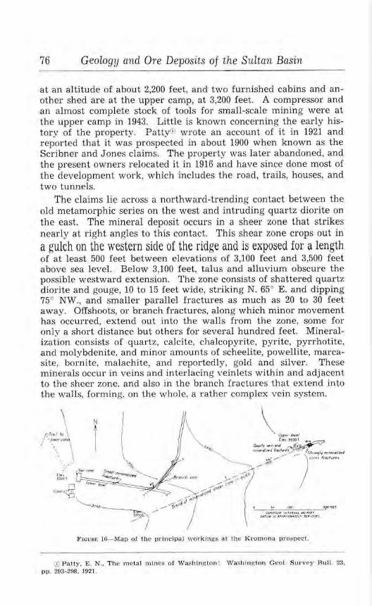
76 Geology and Ore Deposits of the Sultan Basin
at an altitude of about 2,200 feet, and two furnished cabins and another shed are at the upper camp, at 3,200 feet. A compressor and an almost complete stock of tools for small-scale mining were at the upper camp in 1943. Little is known concerning the early history of the property. PattyCiJ wrote an account of it in 1921 and reported that it was prospected in about 1900 when known as the Scribner and J ones claims. The property was later abandoned, and the present owners relocated it in 1916 and have since done most of the development work, which includes the road, trails, houses, and two tunnels.
The claims lie across a northward-trending contact between the old metamorphic series on the west and intruding quartz diorite on the east. The mineral deposit occurs in a sheer zone that strikes nearly at right angles to this contact. This shear zone crops out in
a gulch on the western side of the ridge and is exposed for a length of at least 500 feet between elevations of 3,100 feet and 3,500 feet above sea level. Below 3,100 feet, talus and alluvium obscure the possible westward extension. The zone consists of shattered quartz diorite and gouge, 10 to 15 feet wide, striking N. 65° E. and dipping 75° NW., and smaller parallel fractures as much as 20 to 30 feet away. Offshoots, or branch fractures, along which minor movement has occurred, extend out into the walls from the zone, some for only a short distance but others for several hundred feet. Mineralization consists of quartz, calcite, chalcopyrite, pyrite, pyrrhotite, and molybdenite, and minor amounts of scheelite, powellite, marcasite, bornite, malachite, and reportedly, gold and silver. These mjnerals occur in veins and interlacing veinlets within and adjacent to the sheer zone, and also in the branch fractures that extend into the walls, forming, on the whole, a rather complex vein system.
:....___::.,O_.;;;:"°:.._-~ ?f'O 'U t <CNMV,t INltlf.t,&.L JIIIOIU. r
(J.i, 1W, U 4 PP#('!r/NHl(" Sl• UVrt
F1cuRE 16- Map of the princi pal workings at Lhe Kromona prospect .
(I'I Patty. E. N .. The m etal mines of Washington : Washing ton G eol. Survey Bull. 23. pp. 293-298. 1921.

South Fork of the Suitan River Area 77
The principal workings are shown in figure 16. The lower tunnel, a crosscut, enters the hillside about 150 feet north of the sheer zone and trends S. 80° E. for 250 feet through quartz diorite. It has not yet intersected the main mineralized zone, but would probably do so if extended a short distance. At 95 feet, this adit crosses a 1-inch fracture containing quartz, chalcopyrite, molybdenite, and a small amount of powellite. At 205 feet the adit intersects a vein, trending N. 51 ° E. and dipping 40°-45° NW., which is probably a branch vein from the main sheer zone. A drift follows this vein for about 80 feet. For the first 20 feet, it is 6-24 inches thick and contains 2 to 3 inches of chalcopyrite and iron sulphides, the rest being crushed quartz together with minor calcite, chalcopyrite, pyrite, and a little molybdenite, scheelite, powellite, bornite, and malachite. Beyond this 20-foot shoot, the vein splits, and the drift follows a narrow branch for 60 feet, to where a lens of chalcopyrite and quartz is exposed in the roof for 8 feet. This pocket is 3-21 inches thick. The drift continues about 145 feet farther, but no more mineralization could be seen.
The upper tunnel is in the gulch, approximately 600 feet east of the portal of the lower adit and 300 feet higher in elevation. It is a short drift starting on the main mineralized shear zone and extending into the hillside in a northeasterly direction for 58 feet. Near the face, a 5-foot crosscut extends southwestward. At the portal of the drift a 16- to 18-inch quartz vein, striking N. 70° E. and dipping 70° NW., is exposed for a length of about 15 feet. It contains chalcopyrite, molybdenite, and a small amount of bornite and marcasite. On each side of this vein the quartz diorite is severely shattered and contains abundant interlacing veinlets as much as 1 or 2 inches in thickness. These occur in a zone several feet wide and contain a fair amount of chalcopyrite and molybdenite. This exposure is apparently one that Patty<D examined in 1920 before the drift was driven, and which he estimated at that time would average between 2 and 4 percent copper over a width of 10 feet. The drift now follows this mineralization for about 15 feet to where it intersects a series of well-mineralized cross fractures that strike N. 73° W. and dip 85° NE. These form a zone about 7 feet wide which contains a fair amount of chalcopyrite and should average between 3 and 5 percent copper. A polished specimen of ore from these cross fractures shows quartz diorite traversed by closely spaced quartz veinlets containing chalcopyrite and lesser amounts of molybdenite, pyrite, arsenopyrite, pyrrhotite, and probably sphalerite. The quartz diorite is highly altered, but is not completely replaced. It is somewhat silicified and also contains ininor disseminated chalcopyrite and molybdenite. No mineralization ap-
(D Patty, E . N., op. cit., p . 295.

78 Geology and Ore Deposits of the Sultan Basin
pears in the tunnel beyond this cross zone, indicating the main shear zone may be offset. However, the cross fractures are doubtless an integral part of the main shear zone, being, possibly, a series of mineralized tension cracks that were opened between two planes of movement within the main shear zone. This is common to such zones and was observed in other lode deposits of the basin. The shear zone is not exposed above the upper drift; however, a shallow brush-covered gully extends for several hundred feet farther up the hillside and may mark its trend.
On the opposite side of the ridge and about 1,500 feet eastward from the main workings, a shear zone occurs on a cliff, and its trend and position suggest that it may be an eastern extension of the vein system of the western side. It is well exposed in a natural cave, locally called the "Bear Cave", which was apparently formed by spalling of the fractured quartz diorite under a less-fractured roof. The opening extends into the cliff about 30 feet, tapering toward its end, and may have been lengthened at some time by prospect work. The quartz diorite is not as shattered in this exposure as in the zone on the west side, but exposed on the roof of the cave are several branching fractures 1-2 inches thick and three small lenses 6 to 7 inches thick. These contain quartz and considerable chalcopyrite and bornite together with molybdenite, .scheelite, and powellite. Alteration of the chalcopyrite has produced the bornite, a little chalcosite, and also considerable copper carbonate that occurs on the walls and in cracks within the wall rocks. The scheelite and powellite occur intermixed with the vein material, and in some specimens these minerals are fairly abundant.
OUTLYING PROPERTIES
BORDER QUEEN PROSPECT
The Border Queen prospect, consisting of one unpatented claim, is in Olney Pass, in the NW% sec. 33, (29-9E) . It was originally staked some 40 years ago, later abandoned, and was restaked in 1942 by Richard Sykes of Seattle. The road to the Sultan Basin crosses the property, and a small recently built cabin stands beside the road near the portals of two short tunnels. Figure 17 shows these workings. They were driven northward on a 2- to 4-foot altered and silicified dike or sill that contains finely disseminated pyrite and a trace of arsenopyrite and chalcopyrite. It may also contain some gold. The upper drift is 37 feet long and is on the same level as the road; the other working is 20 feet lower in elevation and extends under the road for 45 feet. The wall rock is platy dark-gray argillaceous schist of the old metamorphic series, which strikes N. 10°-23° W. and dips about 75° NE. The dike strikes about the same but dips a little steeper.

N
0 20
Outlying Properties
40 GOFT.
ARGILLACEOUS SCHIST
F1cuRE 17- Map or the workings at the Border Queen prospect.
LOCKWOOD PYRITE DEPOSIT
79
The Lockwood pyrite deposit is in the NEI/4 sec. 36, (29-8E) and is held under a State land lease by A.H. Brueggeman and associates of Seattle. The property is about 1 mile below the place where the Sultan River leaves the basin to flow westward through its narrow canyon, and the prospect is on the southern wall of this canyon, on the north side of Blue Mountain. It may be reached from Sultan by way of the Olney Creek road for 41h miles, thence by the Blue Mountain road and an old logging road for nearly 5 miles to near the center of sec. 27, (29-8E). From here a trail leads eastward about 3 miles to the property. This trail at one time continued up the Sultan River and connected with the Sultan Basin road near the South Fork, but it has not been used for many years and, in places, is now almost completely obliterated.
The Lockwood deposit was first prospected a number of years ago when a few trenches and a short tunnel were made. In 1934 and again in 1937 the prospect was investigated during the State mineral-survey programs of the Civil Works Administration and the Works Progress Administration. The first of these was by M. W. Jasper and M. C. Butler, mining engineers, and was in the nature of a preliminary examination . The later investigation, in 1937, was under the supervision of P. E. Crane, mining engineer, and included surveying, considerable surface trenching, and sampling. The reports of these investigations have not been published but are available for public inspection at the office of the Division of
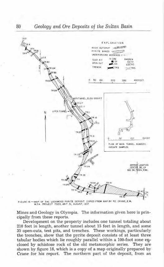
80 Geology and Ore Deposits of the Sultan Basin
EXPL ANA TI ON
ROCK OUTCR OP ~ PYR I TE BAN OS 7}2ZZZZ) ., UNDER GROUNO WORKINGS ::: ::: I ....
TEST PI T OPEN CUT
TRENCH
IN ORE • T.P
,.._ o.c. ,.-:TR5
BARREN OTP
c::::::oc. ;::::::::: TR5
0 50 100 200 300 400FEET
N
oL, .._, .._, _._,_.,.:,.sp;._ __ ,gio:--_ _,,~o,EET
PLAN OF MAIN TUNNEL. NU~ BERS
lflOICATE SAMPLES.
APPRO . U)CATtON CEN'T E NE 1/ot;
SEC 36, 29N ,R8E .
FIGURE 18 - MAP OF THE LOCKWOOD PYRITE DEPOSIT COPIED FROM MAP BY P.E. CRANE, E.M . W PA PROJECT 7020, i,,1T 31, AUGUST, 193 7,
Mines and Geology in Olympia. The information given here is pr incipally from these reports.
Development on the property includes one tunnel totaling about 210 feet in length, another tunnel about 15 feet in length, and some 35 open-cuts, test pits, and trenches. These workings, particularly the trenches, show that the pyrite deposit consists of at least three tabular bodies which lie roughly parallel within a 100-foot zone enclosed by schistose rock of the old metamorphic series. They are sl;J.own by figure 18, which is a copy of a map originally prepared by Crane for his report. The northern part of the deposit, from an

OtLtlying Properties 81
altitude of 1,700 feet to approximately 2,100 feet, trends southeast for 800 feet and dips very steeply southwest. In the next 500 feet, to an altitude of about 2,300 feet, the trend of the zone swings to the southwest, and at 2,350 feet turns abruptly to the east and roughly follows the contour of the hillside for an additional 600 feet. This last part may be a zone separate from the ones below, or it may be a continuation, deformed by faulting or tight folding. The pyritic bodies within the zone vary from 1 or 2 feet to more than 75 feet in thickness and appear to be solely finely granular pyrite; however, abundant quartz and sericite occur as almost microscopic interstitial material. This "ore" is somewhat laminated and has the texture of sandstone. The bodies of pyrite and also the laminations within them have the same strike as the schistosity of the wall rocks.
The assay records of samples taken from the pyritic zones by Jasper and Butler and by Crane are not complete, but are useful to show the nature of the mineralization. The Jasper and Butler map of the property, which was the key to the locations of 12 samples taken by them, has unfortunately been lost since its preparation some 11 years ago; so it is not known what sections of the deposit are represented by the samples.
, lllllJllO No.
Analyses of samples from the Lockwood prospect from, report by by M. W. Jasper and M. C. Btt.tler
[Analyst not known]
\\' f<lth r.01<1 Sulphur Iron OoJlJ)Cr Arsenic Place tnken ( r1. fro.) (0%. (11Crtcnt) (percent) (pcrcem) (J)Crcent)
JlCr ton) --BM-1 ... No. 9 OflC!ll•CUt,., ... 4 6 tr 2.3 Ji.Z nil tr
BM-2 ... No. o open-cut ...... 4 JO tr n.o 22.4 nil tr
BM-3 ... No. 0 OflOll·CUL ...... 2 7 tr 3.2 lG.O nil oil
DM-1 ... No. 9 Ol)('n•Cut .... .. r, 2 .000 2.1.;; 22.5 nil nu
Blll-5 ... No. O open-cut . . .... 7 tr 12.l )6.0 nll nil
BM-6 ... No. 9 open-cut ...... 4 0 tr .L 13.6 1111 nil
BJ\1-7 ••• No. i open-cut ...... 0 0 tr rn. 20.i nil tr
)jM-S .. . No. 3 open-cut ...... 4 6 tr 2G.2 2').6 tr tr
13:M-9 . .. No. 5 OJ)CO·CUt . ..... l 8 tr I 25.3 15.~ nil tr
lHl-10 .. No. 5 open-cul.. .... 3 6 tr 1v.2 17.0 nll oll
Bl\Hl . . No. 6 OJ)eD·C\lt .. ,,., t) 0 tr 25.0 3-1.0 tr
I nll
U)l- 12 .. No 1 t1mnel. ........ chip tr 20.0 :JE.5 I lr all
The assaying of Crane's samples was not done until sometime after his report was written, and the analyses in the table below are from the old records of the State-wide Mineral Investigation Project. This work was done in 1939 (?) at the University of Was~ington under the supervision of Dr. Erwin Pearl, chemist. The data regarding the samples-places taken, widths, and directions- of

82 Geology and Ore Deposits of the Suitan Basin
sampling-are from Crane's original notebook. The locations of the workings that were sampled are shown on figure 18.
Analyses of samples taken from the Lockwood prospect under the su.pervision of P. E. Crane
I Erwin Pearl. analyst]
Working
'l'reru:h ~ ......... . ... .. ..... · ..
Snmple No.
'l'rrneh 4 . ........ . ......... . . ..... . ....... .
'frt\JH'h +............. .... ...... ~©
C/]IPIH'tll, :? .•••. , •..• , . • • • • • • · · •
'J'rcnth ll:; ....... • . •. ......... .
Tn' nch B4 .. ... .. ..........• .. •
'french B5 .. ..... .. .... ..... .. . 'l'rench D!l . ............ .... , · , •
'f'ren<·h Jl,. . . ....... ... ...... . 'l'r,•nrl, n,. . . ........... .... . . T n•11ch B7 ......• ••. .. ..•. .. .•
Trcnel, l3S ......• , •.• • , .... · · · ·
Trc11l'i1 :BS •..••••. .•• .•••.. •• ••
'l.'r('11rt1 n..:. ......... .. .... ... .. . 'rr,•nc:h J3.'- .......... . • .... ...••
Trrneh }}., ................. .. ..
Tr..rwh Tu! •••.•....•.•••••.••••
2(D
:)
4(D
' l'rcru·h Jt'...... .... .. . ........ . .......... .
'l're11 ch J:J."i , . .•..•••••••...• . •..
)luln tunnel. ... .. .. . ........ . .
)hiill l ll ll llf•I. ...•......... . ... .
:\lfiln tunuol. ....•........ •.. ..
:.\loin tun nel. ................. .
i\l.uin hmncl @ ........ . ....•. . .
t·()p<·r tunuel .. . .......•.......
OpCJl ·('llL l'.r ....... . .......... .
Op(:ll·Cllt 2'1' .... .... .. ..... • •. ·
Trr·nc:lt II ..... .......• .........
Trench 11 ...... . ...... . ....... .
Trench 11. ............ . ....... .
Trenc•h 12 .. . .. . .... . ..•• •.... . .
,l'rPll('h 12. , , , . • .... , , . , , . , . , . , ,
'l"rCll<'h 12 ... .•.. •.... •• . •• •. • . •
Tr<·nch 12 . ................ . .. . .
(T) Not ta!'<snyt•<l. © .\ lso: 31 . .;()% SIO::.
2
~
r(D
,,o
\\' idlh (feet)
3
., .. 3
j
!I
7
12
:JO
0
6
r.
Dirt-<:tion lron Sul1ihur )lol~ turc of (11c·rccn t ) (1Wrcc11t) wen:en r)
Sllllll)ling -------- ------
II". 10 ~:.
\I". lo E.
w. to E.
II'. 10 E.
II". to E.
II'. to F..
I\". to K \ V. lo F: .
W. to E.
11·. 10K
11·. to E.
W. tt'l E.
\\". tc, E.
w. to E.
w. to£.
11·. to E.
\\'. to 1,. W. lo E.
W. to 1,:,
E. l o \\'.
'E. to W,
E . to W,
1-:. to \Y.
E. to IT.
W. to .E.
w. t.o Ji:.
\\'. to ·E.
W. loF..
w. to E.
w. loF. .
E. to \\".
E. to 11·.
E.t·ow.
.E. t o \\".
::2.2:; 0.211
. .. :·:·:~~:· ... : : : : : : : : : : : : I::::: ::::::: :l,l,li()
::H.u-'>
:!"1 .011
2:l.:i~
10.iO
\\'0$,:,lt•
:ti,2S
:tj,!)()
~2. :ll)
2V3
2:{, ii
:W.li
:o.;.r,
4S.:
31.S7
29.:17
:?0.!)j
31.2:l
:!-1.41
21.24
:n.no
3'i.OI
o.7:l
0. 11
0.1~
0.11
u.lti
O.H I
O.h7
O.fJ2
1.r~;
1.1~
0. 40
O. Ii
o.r .. :;
0.20
0. 17
0.21)
o.os .

Outlying Properties 83
Analyses of samples taken from the Lockwood prospect under the supervision of P. E. Crane-Contirmed
Working
'l'reuch 12 . .. . .... ...... ....... .
'J'reach 12 ...... .. ...... ....... .
'J'reoch 12 . ...... ...•... ........
Trench 12 . .. .... •.•• .. . . .......
Trench 20 .....•.... • ......... •.
Trench 20 .... . ..... . ......... ..
•rrcod1 20 . .. . . ................ .
'l'rench W ..... .... • ............
'J'rcnch 20 ............... ... ... .
~·•·encl, 20 ...... . ....... . ....• ..
Trench 20 ...... .... . ... . . .. ... .
'l'rllUCh 20 .... • . •• •.• .•. . ... ,,,,
~'r,·nch 20 .............. . ...... .
1'rench 20 .. .................. . .
'l'rr nch :?O .. . ....... ... ........ .
'I'ren ch 20 .. .... .... .. ... . ... . . .
•rreuch 20 .... .. .......... ... .. .
~·rcocll 21. ..... . ........ ...... .
Trench Zl. ..... . .... . . . .. . .... .
'l'rr•nch 21 ...... . ........ . .. . .. .
'frrneh 2 1. . .. ....... .. .. ....... .
'trench 21 .. . .... . .. .... .... ... .
'l'rcrwh 21. . . . ••.•••••..•.. , . .. .
'l'rrncb 21 ........ . .. .... .
'1.'rcnch 2'2 .• .. ..• •• .• . ... .
'l'rench 2Z • •.•••.•..• .••. . .•. . ••
'J"Tenrh 22 .... .... .. ... ....... . .
~rreneh 22" . .•.. •. •••. . .... •• .• •.
Trench 2~ ........... ...... ... . .
1J"r~nch 2.~ ....... . .. ... . .... •• ..
'rr r nch 23 ............ .. .. . .. . . .
Trench 2.'L ... ...... ... . ...... .
Trcrtch 2.'l' ........... ..•........
1'rcuch 2.'l ... . ..... . . ...... . .. . .
• (D ~01 OS~!l)'OO.
Sn u11,Je No.
t,©
(i(D
i
I)
10(1)
11
1:l(D
Z©
3
1
2(1)
3
4Q)
6(j)
W ldih (fcetJ
:;2
:,
6
34
5
2
fj
5
6
5
:;
5
5
Direction or
sumpliug
£ . toW.
E . to W.
1-:. toW.
F.. to W.
W. to £.
W.toK
W. toE.
W.toE.
w. to£.
w. to.I::.
W. toE.
w. to F. .
W, to K
IV . to E.
W. toE.
\\'. to E.
W. toE.
KloW.
E. toW.
E . toW.
E. toW.
E. to w .
E. tow.
E. to W.
IV. to E.
W.toK
W. toE.
W. toE.
W. toE.
W. toE.
W , toE.
W. toE.
W. toE.
W. toE.
Iron (perc·cnt)
Sulphur I Moisture (percent) ( percent)
----·1-----'
2Ji.R2
2:}. 7cj
12.01'
2·1.,7
12.iH
,,·,i.-He
:n. 10
21. IS
25.01
81. t;,
!tl.2
wustc
17.9S
2t.10
23.44
17.58
17.!iO
27 .25
12.09
2"2.57
'11. 16
39. ll
25.27
81.24
40.:J<J
:-lf,.iZ
17.87
Zll .73
25 .39
18.52
0.20
0. 10
o. u
O.li
0.93
0 .2.~
O.S'l
0.10
0.19
0.23
0.17
o.s.;
0.12
0.6-l-
l.54
0.65

84 Geology and Ore Deposits of the Sultan Basin
AnaLyses of samples taken from the Lockwood prospect tinder the supervision of P. E. Crane-Continued
Working
'l 'Tcncll 2:L .................. . .
'J'rench 2:! ................... .. .
'l'rcnch 2-3 . .. . ......... ... ..... .
'l'rcnclJ 2:l ..••.•.•...•••..•...••
'l'rc11d1 28 . .... . ............... .
'J'r cn<·h 2 1. .....•....••.•.......
'fr('Jltb 2a ........ .
'l"rcoch 25 .......•............. .
'french r.; .... .. ............... . 'L'rcncb 25 ... .... • ..............
~l'rf•O(•h 25 . ..... • • , , , • .. • •• , , , ..
'J'cst pits nbo,·c I rench 2.,... . [
'l'reuch :lS ...... . . ...... . .. .
'l'mncb 28 .•••... • ..........
'J1ronch 2:S . . ................ •...
'l'rencb 29 ..... ....•.. .... ... . ..
'l'rcnch W ...... .. . . . ....... . .. .
'l'rcnch 29 ...... . ..••.. ...... • ..
'l'rench 29 ............. .... . ... .
'J'rc.nell $0 . ....... . .. • . . ......•.
'J'rcueh RO •••••••. . ••• •••••••• ••
'l~rencl, ~() . ......... ....... . .. ..
~rreoch $() ••••••••••••• • •• •.••• •
Trench 30 . ... . .... ..... ....... .
'l'rcnch 80 ... . . •. •.... .. .. .
'l'rcnch 31. . .. .......... ... .... .
'!'Tench 31 ....... .. .. . .. . ...... .
'!'Tench 3t ... .. ••. . ........ . ....
Trench 3L ................. . ... .
'l'rench 3l. .... ' ....... ..•...... .
•rrc,1cb 39 . . ...... . ..... •. ......
© Not assayed.
l
Sumple ~o.
11(1)
II
2(i)
l(l)
2© :l
4©
·Xi)
3
·I©
f(D
2(D
3
4@
l\'idlh erect)
:,
5
fj
3
5
5
5
5
Dir·c<'tlon lro u Sul11hur Moisture of (11ercenl) (p.rccn t) (11crecot)
:,('.HIJIJ dfJlg - ---------- -----\\'. loE.
\I' . lo E.
\\", to E.
w. to E.
II". to E.
II". to E.
W. toE.
IY. to F..
w. toE. W. loE.
\\·. l.o E.
E. ~o w.
K Lo W.
t•:. to\\'.
E. 10W.
S. Lo N.
K LoN.
s. to N.
S. toN.
S. toN.
$. toN.
S. loN.
S. to N.
K toN.
$. toN.
S. to N.
S. lo N.
S. toN.
S. to N.
$. toN.
S. to N.
S. loN.
S. toN.
S. toN.
Hi.oi
21.ro
W.3-l
2-1.25
?,5.61
:?'.!. 2!)
36.n
20.JU
waste
20.1 7
21.01
27.63
IG.(i4
J .(i:~
3-1.(la
2.-1.05
39.2'2
14 .26
21.56
~0.72
20.17
:12 .24
28.2-1
2~. 1 1
27.56
o.o;;
0.1>1
0.(>I
o.r.s 0.85
0.61
0.80
0.06
0. 08
0.21
0 .2.3
0.30
0.12
(1.08
0.21
. ... ~~: '.~ .... ". :r::~~ ... I ..... ~:~ ... 2".l..00 20.81 0.20
24 .00 24.GT 0.05

Outlying Properties 85
Analyses of samples taken from the Lockwood prospect under the supervision of P. E. Crane-Continued
Sample Working No.
Trench 39...................... . ..... • ......
'l"lrench 39 ................ . .... .
'J.'rcnch 30 ......... , ....... ... ..
'l'rench 39 ..................... .
'l'rcoch 39 ....... . ............ ..
'l'reoch 40 ................. ... . .
'l'rcoch 40 .. . .................. .
'l'rcocb 40 ....... . ............ ..
'l'reucb 40 ....... . ............. .
'.l.'rencb 40 ..................... .
'J'reoch ,10 ........ .. ........... .
'l'rcocb H ..................... .
'J' rcnch 41 .................... ..
'l'rencb 4L .. . ......... ..... ... ..
'l'reocb ,i.1 ..................... .
'J'.rcncb 41 .. ... ...... . ........ . .
Trench 41 .. . ................. ..
Treoeb •J.l ..................... .
'J.'rench 41 ........... . ........ ..
'J.'rcncb 41. . . .................. .
'J'rcnch 4-L .. . ........ . ......... .
'l'rcnch 41 ..................... .
'J.'rcucb 4L. .................... .
Trench 41 ...... .. .. , . ......... .
'l'rench 41 ..................... .
1'reneh 41 .................... . .
'l'rcoch 4.2 .................... ..
Trench 42 .................... ..
'l'rench ,12 ..................... .
Trench 43 .................. ... .
Trench 43 ..................... .
'J'rcnch 43 ............ ....... .. .
T rench 43 .................... ..
'.l.'rcnch 43 ..................... .
<D Not assayed.
2(l)
3
4(j)
5
G(j)
2(j)
3
4(l)
5
G(j)
7
S(D
9
10(1)
ll
12(1)
13
14(i)
15
2(D
3
2(1)
3
4(l)
5
\\'idth (feet)
15
5
5
5
5
5
5
5
5
5
5
;;
5
;;
5
5
;;
5
;;
;;
;;
5
s
Direction or
S8ll1J)llllg
S. toN.
S. to N.
S. toN.
S. to N.
S. toN.
S. toN.
S. toN.
S. toN.
S. to N.
S. toN.
S. toN.
S. toN.
S. toN.
S. toN.
S. toN.
S. toN.
S. toN.
S. toN.
S. toN.
S. toN.
S. toN.
S. toN.
S. toN.
S. toN.
S. toN.
S. toN.
S. toN.
S. toN.
S. toN.
S. toN.
S. to N.
S. toN.
S. to N.
S. toN.
Iron (percent)
waste
43.19
15.39
40.82
20.li
15.68
Su l1>hur I llloisturo (percent) ( r>ercwt)
45.59 0.19
12.21 0.29
42.38 0.17
19.81. 0.22
H.22 0.10
. .................... T ......... .. 2,;.47 2o.S5 0.21
23.25
21.00
13.94
15.42
2&.73
21.75
39.53
23.26
20.39
11.59
12. 12
30.36
20.48
41.19
0.12
0.24
0.24
0.23
0.08
0.00
0.12
16.&7 16.97 0.34
I·--·~;:~ ...... -~~:~ ... , ..... ~:~- ..

86 Geology and Ore Deposits of the Sultan Basin
Jasper and Butler noted that the sulphur-iron ratio derived from the assay figures was not that of pyrite. Pure pyrite contains 46.7 percent iron and 53.3 percent sulphur, but nearly all of the assays show a higher iron ratio than this. If the material contained iron oxide, this ratio could be accounted for , but both reports point out that their samples were of fresh material. Zapffe,0 after studying several groups of assays from the property, came to the conclusion that at least a part of the mineralization was pyrrhotite. This is corroborated by a study of a polished section of the "pyrite"-bearing material by the writers, which indicates the presence of a weakly magnetic sulphide, probably pyrrhotite. A very small quantity of sphalerite was also found in polished sections. This sulphide and also chalcopyrite were reported by Crane to have been found in two trenches as a small vein within a pyrite-bearing lens, and also as weakly disseminated grains with the pyrite elsewhere. He stated that both of these sulphides are "unimportant as far as the surface areas are concerned." Gold and silver are rE:ported to occur in the deposit, and assays by A. L. Glover, Inc., made for a former owner of the property, show 0.05 to 0.20 ounces of gold and 0.40 to 0.90 ounces of silver per ton.
The Lockwood prospect has been under consideration during the last several years as a source of iron and of sulphur dioxide or sulphuric acid, and a few estimates have been made of the quantity of pyrite-bearing material available for concentration. These estimates, admittedly, are guesses, for only the surface of the deposit is exposed except in the short drift, which does not afford much additional information. Jasper and Butler estimated that the bodies exposed in 1934 would total between 500,000 and 1,000,000 tons. Crane, however, after his work, estimated that the deposit would contain more than 2,500,000 tons.
(j) Zapffe, Carl, Unpublished memorandum on the Lockwood pyrite d epos it, Northe.rn Pacific Railway Co., Land Dept .. Geo!. Div .. 1943.
INDEX
A
AccessiblUty ........... . .... ... ... • ....... . ... .... .. . • .... • .............. . ..... . . . ... Acknowledgments . ................. • .... • . ..... •.... • . • .. • . • .. • . • . . .. . . . . . ..... .... . Ala-Dickson prospect ... . ......... • ......... .. • . ............... • . . ... ... ... . ..... Alpha and Beta placer claims ........ . ............. . . • . .. ... .. . ...... ...... .. ........ Amphibole ...... . . . ............................ . ... . ... . . ......... . . .... .. ....... .. . . Ankerlte .......... . ........ ......... . ......... .... .. . .. .. . ... .. ..... ...... .... .. .. .. . Arsenopyrite ... ... ................. .. .. .. . . . .................... . ...... . . . ...... . .. . Assays of ores. Florence Rae mine ...... .... .. . .•............ . .....•... . • ......... . ..
Florence Rae chromite ....... .. ....•.... . .. .. ..• .. .. . ... ... • .. .. .. • .... • ..... . ... "45" mine ......... ... ......... . . ................ • . • .. • . • .. . .•.. . . . . .. . .... . • . ... Lockwood pyrite deposit. ..... • ....... ... ..... ... • ........... • ... .. ......... • ... . Milwaukee prospect ..... ... . .... . ..... .. ................. • .........•.... • .. . . . .. Mountain Cedar prospect. .. . .................... . .. . .... .. .... • .. .... . . ......... Silver Horseshoe prospect ...................... • . . .. • .... • .. ............•.... • . . Sultan Basin Mining Co., Iowa mine .................. ... . • . ...... .. .. . .......... Sultan Basin Mining Co .. Calumet workings .... •......... . ........... • .. . ... •... Sultan King prospect, assay plan of ........... . .......... • ............. ..... . . ..
Azurite . . . .. . . . . .. . . .. .. .. . .. .. . . . . . . . .. . . . . . .. . .. ... .. . . . . .. . , . . .. , · · · .. · .. · • · ·
B
Bald Mountain stock .. . ... ... • ............ . ...... .. .. • .. ... ...... • ... . . .. ....... • .... Beta placer claim ........ . . ..... . • .... • ............ . .... . ..... • ......... . ....•.... . .. Bibliography . . ....... . .......... . ... ... .. .. .. ... . • . ... .. . .. .. • . ........ . ... ... Bilinite . ..... . . ....... . ... . .... ............. .. ...... .... . ... . .•....•.... . ..... .... • .. Biotite-quartz dlorite. See quartz diorite. Blackman and Brown claims. See Doris prospect. Blue Stone prospect . . . ..... .... ...... .. .............. ... . • ... . ..... • ..... . ........ . .. Border Queen prospect. .. ....... ..... ..... ..... .................... . .... . ........ , .. Boyle·s property. See Mountain Cedar prospect. Bornite ....... . ......... . ..... . ... . ...................... , ..... , ..... . .. . ........... .
C
Page 7-8
8 50-51
50 29 29 29 55 60
43-46 81-85
47 73 48 65 67 53 32
22-23 50 9
31
74 78-79
29
Calci te . ......... .... .. . .... . .................. . .... . .... . ...... ... ................ . .. 29 Calumet workings . .... •... . .. • . • ... . ..... . . .. ... . .. .. • ...... ..... • .... . . . ......... 62. 65-68 Carbonate minerals ... • .. . ...... . . .. ... . .... .. • .... •.. ... .. ... . .. ..... ........ , . . . . . 29 Chalcopyrite . . .... •................ ... .. . . • . .... . ...... . ......... .. ......... . . . 29-30 Chlorite ..... .. .. .. . ........ . ..................... . .... . . . ........................... , 30 Chromite .............. . .. . . ... . .. ....... . .......... . ....................... ... . 21. 35. 36, 60 Clay . . . . . . . . . . . . . . . . . . . . . . . . . . . . . • . . . . . . . . . . . . . . . . . . • . . . . • . . . . . . . . . . . . . . . . . . . . . . . . . . . 18 Climate . . .... .. ........ .. ... . ... . ......... . • .... • . ... . ....... . • ......... • . . . ... . .... . 10-u Conglomerate -argillHe series . . .... . • ..... . ..... • .. . .. ..... .. . .......... • . ... • .. .. , , . 15-17 Copper, production of............ . .... . ...... .. .. . . . . ............... . . . . .. . ... . . .. ... 38 Copper King vein ........ . ..... .. ....... ..... ...... . .... . ... . . ......... . .... . . .. ... 59-60, 66
D
Deu Pree working . ... ..... • ........... . .... . .... .............. , .. .. . . ... • .......... Dike rocks .. .. . . .. ... ..... . ..... .. ........ . • .. . ........ • ... ... • .. .. • ....•...... .... . . Drainage of the area ....... .. .... ......... . .. . . . ............ . .. . ... . . . .. .... . ... ... .. Doris prospect ........... . . ...... . ... . ........... .. .• .... . .... • .... , .... .. . ......... .
E
44-45 26-27
10 60-62
Elk Creek area, prospects in ..... . . .... . . . .......... . ... . . .... . ....... . .... . .... . 74
F Field work Florence Rae mine . ......... ..... .. .... ... . .... . ............. . .. .. ..... , ....... ... ... . 48-55 {garnet) prospect ..... ..... . ...... . .. .. . ...... • ........ ..... . ... . ... ........ ... Forty Five Consolidated Mining Co ................. • ...... .... . • .. . .. ......... • .. ... "45" mine . . ............ ... ........ . ...... .. . . . . ..... . ..... ..... .. . ..... . ........ , , .. . Fossils ....... . ... .. ..... . ..... .. . ........ • . .... . • .... • .. ............. ... .... . .... . ...
8 55-60
70 40
39-46 17

88 Index
G ~~ Galena . ........ ... . . .. . .. . . .. .. . . .. . . . .. . ... . . . . ... . . . .. . ... . . . . . . . ........... .. . . . . . 30 Garnet prospect . . . . . . . . . . . . . . . . . . . . . . . . . . . . . . . . . . . . . . . . . . . . . . . . . . . . . . . . . . . . . . . . . . . . . 70 Geology of the area. principal features of ................. . . . ......... . ............. 13-14 Glacial deposits ...... .. .............. . .... .... ............ . .... . ....... .. ... . . .. ... 11-13. 18 Glaciation, features of . ..... . ... .. . . . ........ .. ........ .. ........ .. .. ... .............. 11-13 Gold, occurrence of .......................... . ............................... . ..... 13, 30, 36
production of . . . . . . . . . . . . . . . . . . . . . . . . . . . . . . . . . . . . . . . . . . . . . . . . . . . . . • . . • . . . . . . . . . . . 38 Golden Eagle prospect. .... . • . .... . .. . ... ........ , . . . . . . . . . . . . . . . . . . . . . . . . . . . . . . . . . . . 75
H Hard to Beat working .......... . .... .. ................... . ... ........................ 44, 45 Hematite ......................... . ........ .... .......... .. ........... .. . ... .......... 30-31 H ick's proper ty. See Sultan King pros pect. History . . . . . . . . . . . . . . . . . . . . . . . . . . . . . . . . . . . . . . . . . . • . . . . . . . . . . . . . . . . . . . . . . . . . . . . . . . • . . . 36-38 Hornblende . . .. . . . . . . .. . . . . . • . . • . .. . . . . . . . . . . . . . . . . . • . . • . . . . . . . . . . . . . . . .. . . . . . . . . . . . . 29
I Igneous rocks . . . . . . . . . . . . . . . • . . . . . . . . . . . . . . . . . . . . . . . . . . . . . . • . . . . . . . . . . . . . . . . . . . . . . . . 18-21 Iowa mine ...... . .......... • ........................ ... ........ .... ... ... .......... 62, 63-65 Iowa Mining Co .......... . •. ...... . ..... ..... .. • ..........•.... . ... .. ... ..... .. . ..... 62. 64 Iron sulphate . . . . . . . . . . . . . . . . . . . . . . . . . • . . . . . . . . . . . . . . . . . . . . . . . . . . . . . . . . . . . . . . . • . . . . . . 31
J Jerry Chatman drift ........ . .... • . ... •.......................•.......•........... ... 62-63 John Newhouse prospect . ... . ..... ....... . ..... . . . . .. . ..... .. .................. . ..... 73 Jones prospect . . . . . . . . . . . . . . . . . . . . . . . . . . . . . . . . . . . . . . . . . . . . . • . . . . . . . . . . . . . . . . . . . . . . . . . 7 4 Junie working . . . . . . . . . . . . . . . . . . . . . . . . . . . . . . . . . . . . . . . . . . . . . • . . . . . . . . . . . . . . . . . . . . • . . . . 60
K Kelly Creek prospect. . . . . . . . . . . . . . . . . . . . . .. . . . . . . . . . . . . . . . . . . . . . . .. . . . . . . . . . .. . . . .. . . 7l Kromona Mines Corporation ......... .. ....... . ................................. . .. . . 75 Kromona prospect . ... ................ . ... ... ...... . ..... . ..... •.. ................... 75-78
L Lambert vein Limestone .. .. . ..... . ........... . ... . ...... . . ... .... ..... . ........... . .... . ..... ... . . Limonlte ................. .. ................... .... ............... .... ... .. .......... . Little Chief prospect. ... . ........... . ................... .. .. . ........ . ...... .. .. . ... . Location of the area .................. .. .. • .... . ....... ............... ........... •... . Lockwood pyrite deposit ............. . .................... . ......................... . Lode deposits, mineralogy ................................................ . ...... . ... .
origin . .... . .............. . ................ . .................... . . •. .. . .. . . . ..... . structure .... .. ...................... .. ....... . ........................ ... • .......
M
59 14 31
49-50 7-8
79-86 29-35
28 28-29
Magmatic segregations ................... . ........ . .... . ... . .. . ..... , ......... .. ..... 35-36 Magneslte . . . . . . . . . . . . . . . . . . . . . . . . . . . . . . . . . . . . . • . . . . . . . . . . . . . . . . . . . . . . .. . . . . . . . . • . . . . . 29 Magnes ium silicates . . . . . . . . . . . . . . . . • . . . . . . . . . . . . . . . . . . . . . . . . . . . . . . . . . . . . . . . . . . . . . . . . 31 Magnetite . . . . . .. . . . . .. . . .. . . .. . . . .. . . .. . . .. . .. . . . . . • . .. . . . . . . .. . . . . . . . . . . . .. . . . . . .. . . 31
!:fa~w~!i~.:::: .. .. : : : : : : : : : : : : : : : : : : : :: : :: : :: : : : : : : : : :: : :: : : : :: : :~::: :: : :: : :: .. : : : : : :~~· 41.!~ Map data, source of.. .... ....... .. ..... ........................ . .......... ..... . . .... 8-9 Marcas ite . . . . . . . . . . . . . . . . . . . . . . . . . . . . . . . . . . . . . . . . . . . . . . . . • . . . . . . . . . . . . . . . . . . . . . . . . . . . 31 Margaret Moshier vein ......... . .. . ..... .. .. .. .. . ........................... .. . . .. . .. 58-59 Marvel prospect . . . . . . . . . . . . . . . . . . . . . . . . . . . . . . • . . . . . . . . . . • . . . . . . . . . . . . . . . . . . . . • . . . . . . 74 Milwaukee prospect ..................................... • ................... . ....... 46-47 Mineraliza t ion , stages of ................................. .. .................. . ....... 33-35 Minerals of the lode deposits . . ............... . .......... . ................ ... .... .... 29-33 Mines and prospects of the area .......... . .......... .. .. ....... ...... .. ............. 36-86 Mining in the area, history of. ...... . ......... • ....... . ............ • ........ ... ...... 36-37
Index 89
Page Molybdenite . . . . . . . . . . . . . . . . . . . . . . . . . . . . . . . . . . . . . . . . . . . . . . . . . . . . . . . . . . . . . . . . . . . . . . . . . 32 Morenosite . . . . . . . . . . . . . . . . . . . . . . . . . . . . . . . . . . . . . . . . . . . . . . . . . . . . . . . . • . . . . . . . . . . . . . . . . . . 32 Mountain Cedar prospect ..... .. .. . ......................... . .... . ................... 71-73 Mystery prospect. See Mountain Cedar prospect.
N Nick el minerals . . . . . . . . . . . . . . . . . . . . . . . . . . . . . . . . . . . . . . . . . . . . . . . . . . . . . . . . . . . . . . . . . . . . . 32 North Coast Copper Co.. . . . . . . . . . . . . . . . . . . . . . . . . . . . . . . . . . . . . . . . . . . . . . . . . . . . . . . . . . . . . . 62 North Fork of the Sultan River area, mines and prospects in ....... . • .... . .......... 51-73
0 Old metamorphic series . ....... • .................. ............. .................... .. 14-15 Ore d eposits, lode deposits ... ..... ..... . ............................. . .... . ... . ...... 28-35
magmatic segregations .... • ................. . ............................ . .... . . 35-36 replacement deposits . . . . . . . . . . . . . . . . . . . . . . . . . . . . . . . . . . . . . . . . . . . . . . . . . . . . . . . . . . . . 36 placer deposits ................ . ........................... .. .......... , . . . . . . . . . . 36
Ore. production of. . . . . . . . . . . . . . . . . . . . . . . . . . . . . . . . . . . . . . . . . . . . . . . . . . . . . .. . . . . . . . . . . . . . 37 -38 Oxidation of ores. . . . . . . . . . . . . . . . . . . . . . . . . . . . . . . . . . . . . . . . . . . . . . . • . . . . . . . . . . . . . . . . . . . . . 34-35
p
Paragenesls of principal vein mJnerals. . . . . . . . . . . . . . . . . . . . . . . . . . . . . . . . . . . • . . . . . . . . . . 33. 34 Paystreak prospect. See Mountain Cedar prospect. Physiography . . . . . . . . . . . . . . . . . . . . . . . . . . . . . . . . . . . . . . . . . . . . . . . . . . . . . . . . . . . . . . . . . . . . . . . . 9-13 Precipitation . .. ......... . ................. .... .. , . . . . . . . . . . . . . . . . . . . .. . . . . . . . . . . . . . . . 11 Peridotite ............. ... ................... •...................... . ................. 18-22 Placer deposl ts ................. . ..... .. .... . . • .... • ......... , . . . . . . . . . . . . . . . . . . . . . . . 13, 36 Pleistocen e deposits ... ...... • . ... . . • . . •.................. . ................... • .... 11-13, 18 Powellite . . . . . . . . . . . . . . . . . . . . . . . . . . . . .. . . . . . . . . . . . . . . . . . . . . . . . . . . . . . . . . . . . . . . . . . .. . . . 32 Production ...... . .. ... ....... ... . ..... ........... ..... . ....... ....... . ......... . ..... 37-38 Pyrargyrite ......... . ............................................... , . . . . . . . . . . . . . . . . 33 Pyrite . ... . . . .. . . . ...... ... .. . . .. . .. ... . . ....... ... . . . . ..... .. . . . ...... ... . . ... . . .. . . . 32 Pyrrhotite . . . . . . . . . . . . . . . . . . . . . . . . . . . . . . . . . . . . . . . . . . . . . . . . . . . . . . . . . . . . . . . . . . . . . . . . . . . 32
Q Quartz ............................ . .................. . ................. . .............. 32 Quartz diorite ................ • ......... • ............................ • .... . ........ . . 22-26 Quaternary deposits .................. . .. . ............... . ..................... . ... 11-13. 18
R Recent deposits . . . . . . . . . . . . . . . . . . . . . . . . . . . . . . . . . . . . . . . . . . . • . . . . . . . . . . . . . . . . • . . . . . . . . . 18 Replacemen t deposits . . . . . . . . . . . . . . . . . • . . . . . . . . . . . . . . . . . . . . . . . . . . . . . . . . . . . . . . . . . . . . . 36 Rocks of the area. . . . . . . . . . . . . . . . . . . . . . . . . . . . . . . . . . . . . . . . . . . . . . . . . . . . . . . . . . . . . . . . . . . . 13-27 Ruby silver ................. . .......... , . . . . . . . . . . . . . . . . . . . . . . . . . . . . • . . . . . . . . . • . . . . . . 33
s St. Theresa prospect .............. . ................................................... 74-75 Scheell te .......... . .. .............. ...... ..................... • ......... , . . . . . . . . . . . . 32 Scope of the report. . . . . . . . . . . . . . . . . . . . . . . . . . . . . . . . . . . . . . . . . . . . . . . .. . . . . . . . . . . . . . . . . . . 8 Scribner and Jones claims. See Kromona prospect. Sericite . . . . . . . . . . . . . . . . . . . . . . . . . . . . . . . . . . . . . . . . . . . . . . . . . . . . . . . . . . . . . . . . . . . . . . . . . . . . . . 33 Serpentine ................ .. ....... . .............................................. 18-22. 31 Siderite ....... ...... .... ! .................................. , . . . . . . . . . . . . . . . . . . . . . . . . . 29 Silver Horseshoe prospect ...................................................... . ..... 47-49 Silver minerals . . . . . . . . . . . . . . . . . . . . . . . . . • . . . . . . . . . . . . . . . . . . . . . . . . . . . . . . . . . . . . . . . . . . . . 33 Silver, production of.......... . .......................... . . . ................... . ..... 38 Snowfall in the area . . . . . . . . . . . . . . . . . . . . . . . . . . . . . . . . . . . . . . . • . . . . . . . . . . . . . . . . . . . . . . . . . 11 Soapstone . . . . . . . . . . . . . . . . . . . . . . . . . . . . . . . . . . . . . . . . . . . . . . . . . . . . . . . . . . . . . .. . . . . . . . . . . . . . 18, 71 South Fork of the Sultan River area. prospects in ...... ... ..... . .. . . ..... ... ... . .... 74-78 Specular hematite ....................................................... .. .......... 30-31 Sphalerite ...................... . ...... .. . . . . .... . ........... . ....................... 30, 33 StUaguamlsh and Sul tan Mining Co... ... . .......... . .. . .... . . . .......... . .. .. . .. .. . . 49

90 Index
Sultan Basin Mining Co .. ....... .... ... . ... .. ... . ...... . .... . ............... . ...... . . Sultan group (or mine). See Sultan King prosµecl. Sultan King Mining Co ... . .. .. .... .. . .. . .......... . . .. .. . . ...... ............... . .. .. . Sultan King prospect .................. . ............... •. ...... . . . ..• .. . .... • ... . ... . Sultan Queen prospect. See Sultan King prospect. Sultan River, Pleistocene history of. ...... .. .. . ....... . ... . ... . . .. .. . . .. ...... . . . .. . Sunrise Mining Co .......... ... ... .. .. ............ . . . . . ..... .. ...... . ... . .... ........ . Sunrise prospect .... . ................ .. ...... ........ . ..... . . . ..... . . . ..•......... . ..
T
Talc Temperature ..... ... . . ...... . ........... . ............. . .... •. . •. .. .... . • ... . The "'45·• Mines. Inc ... . . .. ........ .. ......... .. .. ...... . .... . . . . .. •... .... • . Topography ... ......... • ... . ........ .. .... . ...... • ........ . .. . .... • .......... . .......
V
Vegetation .. .. .......... . .......... . ......... . .... . .. • ......... ... • ... .. .. • . ......... Veins. See lode deposits.
w
Page 62- 68
52 51-55
12-13 68
68-70
31 10 39
9- 10
11
Washington Molybdenum Co. .. ..................... .. .. . .... .. . . ... ....... . . . . . ..... 75 Williamson Creek area, mines and prospects In .. .. ... . ....... . . , ..•.. .. . . •. . • ... . ... 39-51
X Xeno liths 23-24
z Zoning . geothermal 33-34
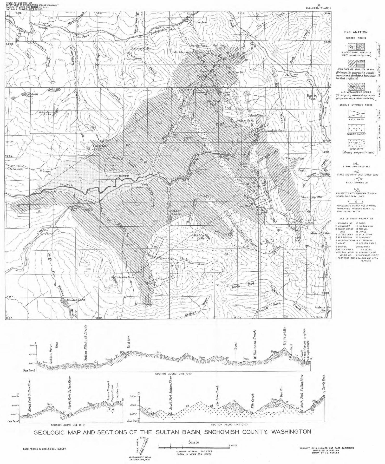
STATE OF WASHINGTON DEPARTMENT OF CONSERVATION ANO DEVELOPMENT DIVISION OF MINES ANO 11111111 GEOLOGY SHELDON L GLOVER, SUPERVISOR
A " ti C qOOO' a,
.j:,. co
~ 4,000' I:!
2,000'
Sea.feyel
r... ~
~ ~
B ~ 6,000'
i'.: ~
4,000' t J...
~ 2,000' Q
~~~\\,,n 1
Sea. l,enl
J...
~ ~ ~
~ ~ ~ ~ ::S
J...
~
SECTION ALONG LINE
-tc! ~
C -+- l ::E -0 ~
-0 C d C Cl) co (lj
~ co -~ ~ ~
SECTION ALONG LINE A-A'
<J)
"' ce Cl>
·~ C C 6,000' ::s
.,t!
J
4,000'
2,000'
Sea.l.eYel B-B' SECTION ALONG LINE C-C'
C -+-~ \.. :I
J? 00 di
C -+-~ -0
&
V ~
CT' \.. Cl
~~ 0 C,
~ ~ <+- E
..... ::: ..Q -; 'iii O"
~~5
.~ ~
J 0 't1 ~
..... u A:
X X
"
..Y. 0
cf 0 :c 1> l'.)
c·
EXPLANATION
BEDDED ROCKS
)Q; <l z Q; UJ 1-<l :> 0
ff@rl ~ CONGLOMERATE-ARGILLITE SERIES o
~ {Principally quartzitic co11flo· .,, meraie aru:lsandst.one.Some in.4,r. ~ bedded ar9illite)
OLD METAMORPHIC SERIES
(Principal,l,y sedinneni.ary in, ori-9in; some serpeniine included)
IGNEOUS INTRUSIVE ROCKS
1--~~I LATE DIKES
)< X X
< •qd< X
• • • QUARTZ OIORITE
PERIOOTITE
{Mosily serpeniinized}
4tl-STRIKE ANO OIP OF BEO
fO!}-STRIKE ANO OIP OF OVERTURNED BEDS
-(70• FAULT, SHOWING OIP
~9 PROSPECTS WITH UNKNOWN OR ABAN-
DONED BOUNDARY LINES
\ 12 \ APPROXIMATE BOUNDARIES OF MINING
PROPERTIES. NUMBERS REFER TO NAME IN LIST BELOW
LIST OF MINING PROPERTIES
I 45 MINES, INC. 12 DORIS
2 MILWAUKEE 13 SULTAN KING 3 SILVER HORSE- 14 MARVEL
SHOE 15 JONES
4 LITTLE CHIEF 16 BLUE STONE 5 ALA DICKSON 17 NEWHOUSE
6 MOUNTAIN CEOAR 18 ST THERESA
7 48-55 19 GOLDEN EAGLE
8 SUNRISE 20KROMONA 9 KELLY CREEK MINES, INC.
IOSULTAN BASIN 21 BORDER QUEEN
)er: <l i== er: UJ I-
>er: <l ;: er: UJ I-
~ 0 0 N 0 U)
UI ~
MINING CO. 22 LOCKWOOD PYRITE
II FLORENCE RAE 23ALPHA ANO BETA PLACERS
GEOLOGIC MAP AND SECTIONS OF THE SULTAN BASIN, SNOHOMISH COUNTY, WASHINGTON
~~3~, ~ I-~
BASE FROM U. S. GEOLOGICAL SURVEY
APPROXIMATE MEAN DECLINATION, 192 1
I
2 Scale
0
CONTOUR INTERVAL 500 FEET DATUM IS MEAN SEA LEVEL
GEOLOGY BY A.K. GUARD ANO WARD CARITHERS SURVEYED IN 1943·44
DRAWN BY V. L. FENLEY


![[Andrew D. Miall] the Geology of Fluvial Deposits(BookZZ.org)](https://img.dokumen.tips/doc/110x75/55cf8cc65503462b138fa894/andrew-d-miall-the-geology-of-fluvial-depositsbookzzorg.jpg)