Embed Size (px)
Citation preview
Ahmad M and Munson TJ (compilers)
Northern Territory Geological SurveySpecial Publication 5
Chapter 26: Victoria Basin
Geology and mineral resourcesof the Northern Territory
BIBLIOGRAPHIC REFERENCE: Dunster JN and Ahmad M, 2013. Chapter 26: Victoria Basin: in Ahmad M and Munson TJ (compilers). ‘Geology and mineral resources of the Northern Territory’. Northern Territory Geological Survey, Special Publication 5.
DisclaimerWhile all care has been taken to ensure that information contained in this publication is true and correct at the time of publication, changes in circumstances after the time of publication may impact on the accuracy of its information. The Northern Territory of Australia gives no warranty or assurance, and makes no representation as to the accuracy of any information or advice contained in this publication, or that it is suitable for your intended use. You should not rely upon information in this publication for the purpose of making any serious business or investment decisions without obtaining independent and/or professional advice in relation to your particular situation. The Northern Territory of Australia disclaims any liability or responsibility or duty of care towards any person for loss or damage caused by any use of, or reliance on the information contained in this publication.

26:1
Victoria Basin
INTRODUCTION
The Neoproterozoic Victoria Basin is exposed in the Victoria River area of the northwestern NT, where it unconformably overlies the Palaeo–Mesoproterozoic Birrindudu Basin (Figure 26.1). Previous workers (eg Blake et al 1975, Sweet 1977) recognised the Birrindudu and overlying Victoria basins as being distinct depositional basins separated by an unconformity, but there was no consensus as to which of several unconformities within the overall succession marked the break. Dunster et al (2000) and Cutovinos et al (2002) used the unconformity at the base of the Wattie
the basins by positioning the break at the unconformity between the Tijunna and Auvergne groups, so that only the Auvergne Group is assigned to the Victoria Basin. This is supported by the presence of detrital zircons within the
underlying strata than with those of the Auvergne Group
an area of >32 500 km2 within the NT, although its total extent under younger covering rocks is somewhat greater. It spans the Western Australian–Northern Territory border, but is much more widely distributed in the latter.
The Auvergne Group contains seven formations (Table 26.1) that were initially deposited in a northeast-trending intracratonic sag basin in southwestern AUVERGNE1 and western WATERLOO (Figure 26.2). In ascending order, these are the Jasper Gorge Sandstone, Angalarri Siltstone, Saddle Creek Formation, Pinkerton Sandstone, Lloyd Creek Formation, Spencer Sandstone and Shoal Reach Formation. The succession attains a thickness of 950 m and forms most of the Pinkerton, Spencer, Yambarra and Newcastle Ranges. It is best exposed in AUVERGNE, but extends to all the adjacent NT mapsheets (Figure 26.1). The Victoria River Fault Zone limits its present northwestern distribution. In drillhole Bullo River-1 (Figure 26.2), the Auvergne Group directly overlies granite basement. This demonstrates that the Birrindudu Basin is not present beneath the Victoria Basin in the northwest.
from the Auvergne Group, but it is believed to have
Supersequence 1 of the Centralian A Superbasin (Walter et al 1995, see Centralian Superbasin), which includes the Amadeus, Ngalia, Murraba, Wolfe and Georgina basins in the Northern Territory. SHRIMP U-Pb dating of detrital zircons from the basal Jasper Gorge Sandstone have given a conservative maximum deposition age of 1322 ± 22 Ma, with two isolated younger grains at ca 1243 Ma and 1171 Ma (Carson 2010). A poorly constrained Rb-Sr wholerock age of 838 ± 80 Ma has been obtained for the Angalarri Siltstone from the lower part of the Auvergne Group (Webb and Page 1977), and this is the best existing
estimate of the age of the group. The minimum age of the succession is constrained by an inferred age of about 635 Ma or younger for the Moonlight Valley Tillite of the overlying Wolfe Basin, based on correlations of this unit with the Olympic and Elatina formations from the Amadeus Basin and Adelaide Fold Belt, respectively (Grey and Corkeron 1998, see Centralian Superbasin).
The most current references for the Auvergne Group are Sweet et al (1974) and Dunster et al (2000) and the following
Chapter 26: VICTORIA BASIN JN Dunster and M Ahmad
HallsCreekOrogen
OrdBasin
BirrinduduBasin
Pine CreekOrogen
MoneyShoal Basin
Wiso BasinTANAMIREGION
WolfeBasin
WolfeBasin
Carr-BoydBasin
BastianBasin
BonaparteBasin
DalyBasin
Daly Basin
DARWIN
Kununurra
Wyndham
BonaparteBasin
FitzmauriceBasin
12°
13°
14°
15°
16°
17°
18°
19°
128° 129° 130° 131° 132°
A09-242.ai
NORTHERNTERRITORY
WESTERNAUSTRALIA
road
railway
locality
Mesozoic–Cenozoic
Palaeo–Mesoproterozoic basins
Palaeo–Mesoproterozoic orogens
Archaean
Neoproterozoic–Palaeozoic
early Cambrian Kalkarindji Province
Victoria Basin
location ofFigure 26.2
Wyndham
0 100 200 km
Figure 26.1. Regional geology of Victoria Basin in NT and WA. NT geological regions from NTGS 1:2.5M geological regions GIS
from Tyler and Hocking (2001); some small outliers/inliers
from Glass and Phillips (2006).
Current as of March 2010
1 Names of 1:250 000 mapsheets are shown in large capital letters eg AUVERGNE.
Figure 26.2
Geology and mineral resources of the Northern Territory Special publication 5

Victoria Basin
26:2
Limbunya Fault
Negri Fault
0 50 kmJasper Gorge Sandstone
Angalarri Siltstone
Saddle Creek Formation
Pinkerton Sandstone
Lloyd Creek Formation
Shoal Reach Formation
Spencer Sandstone
?Mesoproterozoic–?late NeoproterozoicA09-243.ai
Mesozoic–Cenozoic
Palaeo–Mesoproterozoic basins
Palaeo–Mesoproterozoic orogens
drillhole
Bullo River-1
Neoproterozoic–Palaeozoic
early Cambrian Kalkarindji Province fault
AUVERGNE
WATERLOO
LIMBUNYA WAVE HILL
PORT KEATS
VICTORIA RIVER DOWNS
DELAMERE
FERGUSSON RIVER
Fau
lt
Zon
eVictoria
Rive
r
HallsCreekFault
Spencer
Range Fault
Pinkerton Range Fault
Giants Reef Fault
Kalkarindji Province
KalkarindjiProvince
OrdBasin
Birrindudu Basin
BirrinduduBasin
FitzmauriceBasin
WolfeBasin
VictoriaBasin
PineCreekOrogen
Bonaparte Basin
Daly Basin
CarpentariaBasin
CarpentariaBasin
WisoBasin
1:250 000 mapsheetDELAMERE
Figure 26.2. Exposure of the seven formations that constitute the Auvergne Group in the NT, showing major faults, derived from GA 1:1M and NTGS 1:250K GIS datasets. NT geological regions from NTGS 1:2.5M geological regions GIS dataset.
Geology and mineral resources of the Northern Territory Special publication 5
26:3
Victoria Basin
discussion is based on those works, with only minor amendments.
?MESOPROTEROZOIC–?LATE NEOPROTEROZOIC
Auvergne Group
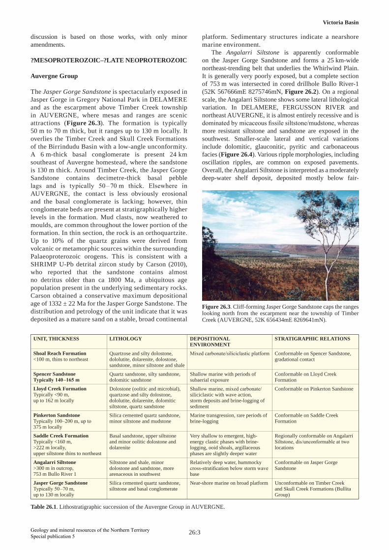
The Jasper Gorge Sandstone is spectacularly exposed in Jasper Gorge in Gregory National Park in DELAMERE and as the escarpment above Timber Creek township in AUVERGNE, where mesas and ranges are scenic attractions (Figure 26.3). The formation is typically 50 m to 70 m thick, but it ranges up to 130 m locally. It overlies the Timber Creek and Skull Creek Formations of the Birrindudu Basin with a low-angle unconformity. A 6 m-thick basal conglomerate is present 24 km southeast of Auvergne homestead, where the sandstone is 130 m thick. Around Timber Creek, the Jasper Gorge Sandstone contains decimetre-thick basal pebble
AUVERGNE, the contact is less obviously erosional and the basal conglomerate is lacking; however, thin conglomerate beds are present at stratigraphically higher levels in the formation. Mud clasts, now weathered to moulds, are common throughout the lower portion of the formation. In thin section, the rock is an orthoquartzite. Up to 10% of the quartz grains were derived from volcanic or metamorphic sources within the surrounding Palaeoproterozoic orogens. This is consistent with a SHRIMP U-Pb detrital zircon study by Carson (2010), who reported that the sandstone contains almost no detritus older than ca 1800 Ma, a ubiquitous age population present in the underlying sedimentary rocks. Carson obtained a conservative maximum depositional age of 1332 ± 22 Ma for the Jasper Gorge Sandstone. The distribution and petrology of the unit indicate that it was deposited as a mature sand on a stable, broad continental
platform. Sedimentary structures indicate a nearshore marine environment.
The Angalarri Siltstone is apparently conformable on the Jasper Gorge Sandstone and forms a 25 km-wide northeast-trending belt that underlies the Whirlwind Plain. It is generally very poorly exposed, but a complete section of 753 m was intersected in cored drillhole Bullo River-1 (52K 567666mE 8275746mN, Figure 26.2). On a regional scale, the Angalarri Siltstone shows some lateral lithological variation. In DELAMERE, FERGUSSON RIVER and northeast AUVERGNE, it is almost entirely recessive and is
more resistant siltstone and sandstone are exposed in the southwest. Smaller-scale lateral and vertical variations include dolomitic, glauconitic, pyritic and carbonaceous facies (Figure 26.4). Various ripple morphologies, including oscillation ripples, are common on exposed pavements. Overall, the Angalarri Siltstone is interpreted as a moderately deep-water shelf deposit, deposited mostly below fair-
Figure 26.3. Cliff-forming Jasper Gorge Sandstone caps the ranges looking north from the escarpment near the township of Timber Creek (AUVERGNE, 52K 656434mE 8269641mN).
UNIT, THICKNESS LITHOLOGY DEPOSITIONAL ENVIRONMENT
STRATIGRAPHIC RELATIONS
Shoal Reach Formation<100 m, thins to northeast
Quartzose and silty dolostone, dololutite, dolarenite, dolostone, sandstone, minor siltstone and shale
Conformable on Spencer Sandstone, gradational contact
Spencer Sandstone Quartz sandstone, silty sandstone, dolomitic sandstone
Shallow marine with periods of subaerial exposure
Conformable on Lloyd Creek Formation
Lloyd Creek FormationTypically <90 m, up to 162 m locally
Dolostone (oolitic and microbial), quartzose and silty dolostone, dololutite, dolarenite, dolomitic siltstone, quartz sandstone
siliciclastic with wave action, storm deposits and brine-logging of sediment
Conformable on Pinkerton Sandstone
Pinkerton Sandstone
375 m locally
Silica cemented quartz sandstone, minor siltstone and mudstone
Marine transgression, rare periods of brine-logging
Conformable on Saddle Creek Formation
Saddle Creek FormationTypically <160 m, >222 m locally, upper siltstone thins to northeast
Basal sandstone, upper siltstone and minor oolitic dolostone and dolarenite
Very shallow to emergent, high-energy clastic phases with brine-logging, ooid shoals, argillaceous phases are slightly deeper water
Regionally conformable on Angalarri
locations
Angalarri Siltstone>300 m in outcrop, 753 m Bullo River 1
Siltstone and shale, minor dolostone and sandstone, more arenaceous in southwest
Relatively deep water, hummocky
base
Conformable on Jasper Gorge Sandstone
Jasper Gorge Sandstone
up to 130 m locally
Silica cemented quartz sandstone, siltstone and basal conglomerate
Near-shore marine on broad platform Unconformable on Timber Creek and Skull Creek Formations (Bullita Group)
Table 26.1. Lithostratigraphic succession of the Auvergne Group in AUVERGNE.
Geology and mineral resources of the Northern Territory Special publication 5

Victoria Basin
26:4
weather wave base, but at least partly above storm wave
water ripple morphologies. Webb and Page (1977) obtained a Rb-Sr poorly constrained whole-rock age of 838 ± 80 Ma for this unit.
The Saddle Creek Formation appears to be regionally conformable on the Angalarri Siltstone, but locally, the contact can be erosional and an angular unconformity of about 10º has been documented in AUVERGNE ( ). Its overall thickness is typically less than 160 m, but a maximum of 222 m has been measured in
AUVERGNE (Dunster et al 2000). The formation contains a basal sandstone usually less than 10 m thick, overlain
sandstone, dolarenite and minor shale. An ooid grainstone
of metres below the top of the formation. Sedimentary structures in the basal sandstone include cross-bedding,
morphologies, mudcracks, synaeresis cracks in ripple swales, pseudomorphs and casts after halite, sole marks and current lineations. The Saddle Creek Formation was deposited in very shallow to emergent conditions, initially with intermittent high-energy clastic phases and brine-logging of the sediment. The siltstone represents slightly deeper, stable conditions and the oolitic dolostone was probably deposited in higher energy shoals.
The Pinkerton Sandstone conformably overlies the Saddle Creek Formation and forms a resistant capping on the main escarpments and dissected plateaux of the Pinkerton and Yambarra ranges. It also outcrops in Spencer Range and forms a prominent hogback ridge along the southeastern side of the Victoria River Fault Zone. A basal medium-
sandstone and siltstone up to 30 m thick that contains
pavements (Figure 26.6
exposed. Dolomitic phases, and rare cm-scale cubic casts after halite, which are associated with various ripple morphologies, are also present. The Pinkerton Sandstone
The Pinkerton Sandstone probably represents a marine transgression with high-energy nearshore conditions and more terrigenous clastic input than the formations above or below.
Sparse outcrops of the Lloyd Creek Formation are characterised by oolitic (Figure 26.7) and stromatolitic
present in the carbonate rocks. Subordinate lithologies include laminated dolostone, dolomitic siltstone and imbricated plate breccia. Recessive intervals may be of
A09-244.ai
. Probable unconformable contact (shown) between Angalarri Siltstone (below) and Saddle Creek Formation (AUVERGNE, 52K 570730mE 8253670mN, after Dunster et al
Figure 26.4. Angalarri Siltstone (after Perring and Jones 1991). (a) Grey-green siltstone underlying darker carbonaceous shale. Cliff is about 10 m high. (b) Limonite, probably after pyrite, occurring as thin laminae in Angalarri Siltstone in Koolendong Valley.
b
a
Geology and mineral resources of the Northern Territory Special publication 5

26:5
Victoria Basin
dolomitic shale. Pseudomorphs of swallow-tail gypsum twins, and casts of pagoda halite and of halite hoppers up to 4 cm across indicate an evaporitic overprint. Pinolitic prisms of ferroan carbonate are interpreted as a diagenetic
pseudomorphs of primary evaporite. The formation is conformable on Pinkerton Sandstone and is typically less than 90 m thick, but ranges up to 162 m. A shallow-marine mixed carbonate/siliciclastic environment of deposition, characterised by wave action and occasional brine-logging of the sediment, is postulated. Imbricated plate breccias are interpreted as storm deposits.
The Spencer Sandstone is conformable on the Lloyd Creek Formation and typically ranges between 140 m and 165 m in thickness. In most areas, the basal Spencer
sandstone up to 15 m thick. It contains abundant small-scale cross-lamination and ripple marks. Moulds after mud
sandstone and friable quartzose siltstone. Mudcracks, ripple marks, cross-beds and thin pebble lags are common. The uppermost Spencer Sandstone is typically dolomitic. Halite casts and pseudomorphs up to several centimetres across occur in swales between ripples. The Spencer Sandstone was probably deposited in a shallow-marine environment with periods of subaerial exposure.
The Shoal Reach Formation conformably overlies the Spencer Sandstone and the contact is gradational. The formation is poorly exposed, apart from low benches and ground-level outcrops of quartzose and silty dolostone, dololutite, dolarenite, siltstone and sandstone, and intraformational conglomerate in places. It is probably between 70 m and 100 m thick over most of its distribution, but thins to the northeast. The Shoal Reach Formation was deposited on a mixed carbonate-siliciclastic marine shelf.
ripple marks and graded beds indicates a shallow protected environment above fair-weather wave base.
STRUCTURE, METAMORPHISM AND IGNEOUS ACTIVITY
The rocks of the Victoria Basin are unmetamorphosed and
is no known evidence of igneous activity. In contrast to the underlying Birrindudu Basin, there is little evidence of syndepositional fault activity or uplift during the Victoria Basin’s depositional history, other than possible differential uplift prior to the deposition of the Saddle Creek Formation. However, subsequent locally intense deformation is associated with major faults. The greatest fault movements probably occurred prior to the Cambrian, but some reactivation postdates the early Cambrian Antrim Plateau Volcanics.
The Victoria River Fault Zone (Figure 26.2) is a 1 km-wide belt of intense deformation affecting the Auvergne Group. There were several periods of movement in the fault zone and it includes a major strike-slip component. Sweet (1977) and Slade (1987) interpreted the present
south compression. A major left-lateral component was also inferred. This is consistent with a continuation of the Victoria River Fault Zone into the Halls Creek Fault to the south, as interpreted by Thorne and Tyler (1996). However, a right-lateral sense is more consistent with a possible extension of the Victoria River Fault Zone into the Giants Reef Fault to the north. Rocks within the Victoria River Fault Zone are steeply dipping and overturned by up to 75° from vertical. Shear zones that are tens of metres wide indicate both near-vertical and strike-slip components to the latest fault movements. Conspicuous quartz blows occur in dilational zones, and areas of isoclinal folding are present.
Figure 26.6. Ripples in Pinkerton Sandstone in Pinkerton Range (AUVERGNE, 52K 569700mE 8256100mN, after Dunster et al
Figure 26.7(AUVERGNE, 52K 569700mE 8256100mN, after Dunster 1998).
Geology and mineral resources of the Northern Territory Special publication 5

Victoria Basin
26:6
Several major faults parallel to the Victoria River Fault Zone offset the Auvergne Group to varying extents. An unnamed fault parallels the Newcastle Range and is conspicuous on air-photos, where it can be traced over 50 km, but there is little apparent vertical displacement.
The Pinkerton Range and Spencer Range faults are parallel, separated by 7 km, and extend discontinuously southwest for over 100 km from the Victoria River into WATERLOO. There appears to be varying vertical displacements associated with their component faults. The maximum offset on the Pinkerton Range Fault is along Lloyds Creek where the Pinkerton and Spencer sandstones are juxtaposed. This indicates an apparent vertical displacement of 120 m. The Spencer Range Fault has a maximum throw of 500 m and there is a narrow band of intense deformation on its northwest side. This fault has been interpreted as either a steeply dipping normal fault with two episodes of movement and collapse on the northwestern side, or as a low-angle reverse fault (Sweet 1977). The north side of the Spencer Range Fault has a
River Fault Zone and they probably share a common history.
Northeast trending faults are cut by numerous shorter orthogonal faults. These are nearly vertical and are generally downthrown to the southwest by less than 200 m (Sweet et al 1974). Some appear to have a similar lateral displacement. A series of northeast-trending anticlines and synclines, and relatively more intense faults occur in the area surrounding the junction of the Victoria River Fault Zone and Halls Creek Fault. Synclines and anticlines, tens of kilometres long, are developed along the southeastern side of the Victoria River Fault Zone. Examples at Paperbark Creek and west of Koolendong Valley are associated with bends in the fault zone. An area east of Koolendong Valley contains several broad synclines and anticlines, and a basin-shaped syncline, 15 km across, is present in the southeast of AUVERGNE.
MINERAL RESOURCES
Base metals
Carbonate and shale units of the Auvergne Group are prospective for base metals. The earliest mineral exploration in the basin related to conceptual targeting for stratiform copper and this theme was revisited when a BHP Minerals Pty Ltd–Carnegie Minerals NL joint venture investigated the potential for sediment-hosted copper mineralisation in the Auvergne Group along the Victoria River Fault Zone, using semi-detailed stream sediment sampling (Stephens 1997). The Angalarri Siltstone is known to contain pyritic shale units and may be prospective for stratiform sediment-hosted base metals mineralisation, but exploration to date has been unsuccessful. This unit has not been explored systematically, because so much of it is under cover. As part of an exploration program for diamonds and base metals, BHP drilled six shallow (6–60 m) percussion holes in the Angalarri Siltstone on Whirlwind Plain (Taylor 1981). Although the holes were targeted on magnetic anomalies,
Petroleum
The Proterozoic rocks in and around AUVERGNE were
Laing and Allen (1956) and Laing (1982), who followed up 1890s reports of bitumen in water wells and petroleum seeps in the Spencer Range. The Angalarri Siltstone was believed to be the source of a water sample from a spring near the Bullo River access road that contained 2.3 ppm of hydrocarbons (Laing and Webby 1982). A fully-cored 970 m petroleum well, Bullo River-1, was drilled by Queensland Petroleum during 1984. It intersected the Auvergne Group, from the Saddle Creek Formation to the Jasper Gorge Sandstone, and was terminated in granite basement. No shows were reported and there has been no further exploration since then.
Uranium
The Auvergne Group in the Spencer and Pinkerton ranges was explored for uranium by Broken Hill Proprietary Co Ltd in the late 1960s. Scintillometer and magnetometer surveys
1970 (Gunn 1970). This area was again under exploration licence by several companies in the mid 2000s uranium boom, but little work was undertaken.
Diamonds
Early exploration for diamonds in the Victoria Basin was focused in the vicinity of the Victoria River Fault Zone (Geopeko Ltd) and Pinkerton Ranges (BHP, Aberfoyle Resources Ltd). More regional programs were undertaken by Ashton Mining NL and Stockdale Prospecting Ltd. Collectively, these surveys provided at least reconnaissance stream sediment coverage over most of the Victoria Basin. However, later work focused on the older Birrindudu Basin after the discovery of the Timber Creek kimberlite pipes.
Industrial minerals
Pods and veins of barite occur in the Angalarri Siltstone and Saddle Creek Formation. Barite veins up to 30 cm wide have been reported in the Angalarri Siltstone in the southern Koolendong Valley (Perring and Jones 1991). A lens of barite 6 m long and 2 m wide occurs as part of a fault blow near the highway 1.5 km northwest of Saddle Creek (Pontifex and Sweet 1972). This, and other nearby occurrences have been mapped, costeaned, drilled and sampled (Willis and Newton 1975), but no commercial exploitation has been reported.
REFERENCES
Blake DH, Hodgson IM and Smith PA, 1975. Geology of the Birrindudu and Tanami 1:250 000 sheet areas, Northern Territory. Bureau of Mineral Resources, Australia, Report 174.
Carson CJ, 2010. The Victoria and Birrindudu basins: A U-Pb SHRIMP study and review of resource potential: in
Geology and mineral resources of the Northern Territory Special publication 5

26:7
Victoria Basin
‘Annual Geoscience Exploration Seminar (AGES) 2010. Record of Abstracts’. Northern Territory Geological Survey, Record 2010-002.
Cutovinos A, Beier PR, Kruse PD, Abbott ST, Dunster JN and Brescianini RF, 2002. Limbunya, Northern Territory (Second Edition). 1:250 000 geological map series explanatory notes, SE 52-07. Northern Territory Geological Survey, Darwin.
Dunster JN, 1998. Reconnaissance of the Proterozoic rocks of the Victoria River region. North Ltd. Northern Territory Geological Survey, Open File Company Report CR1998-0082.
Dunster JN, Beier PR, Burgess JM and Cutovinos A, 2000. Auvergne, Northern Territory (Second Edition). 1:250 000 geological map series explanatory notes, SE 52-15. Northern Territory Geological Survey, Darwin.
Glass LM and Phillips D, 2006. The Kalkarindji Continental Flood Basalt Province. A new Cambrian Large Igneous Province in Australia with possible links to mass extinction. Geology 34(6), 461–464.
Grey K and Corkeron M, 1998. Late Neoproterozoic stromatolites in glacigenic successions of the Kimberley region, Western Australia: evidence for a younger Marinoan glaciation. Precambrian Research 92, 65–87.
Gunn M, 1970. Prospecting Authority 2466 (2061) Spencer
Ltd. Northern Territory Geological Survey, Open File Company Report CR1970-0017.
Laing ACM, 1982. Photogeology and preliminary petroleum prospects of onshore petroleum exploration OP 225, Victoria River. Queensland Petroleum Pty Ltd. Northern Territory Geological Survey, Open File Petroleum Report PR1982-0043.
Laing ACM and Allen RJ, 1956. Geology of the Victoria River area, OP 1. Associated Freney Oil Fields NL. Northern Territory Geological Survey, Open File Petroleum Report PR1956-0003.
Laing ACM and Webby JK, 1982. Bullo River geological survey – OP225, Northern Territory. Queensland Petroleum Pty Ltd. Northern Territory Geological Survey, Open File Petroleum Report PR1982-0079.
Owen HB, 1954. Report on Bonaparte Gulf Region. Northern Territory Geological Survey, Technical Report GS1954-002.
Perring RJ and Jones MT, 1991. Surrender report EL7045 Koolendong 9th Nov 1990 to 8th Nov 1991. Pancontinental Mining Limited, base metal project.
Northern Territory Geological Survey, Open File Company Report CR1991-0587.
Pontifex IR and Sweet IP, 1972. Auvergne, Northern Territory (First Edition). 1:250 000 geological map series explanatory notes, SD 52-15. Bureau of Mineral Resources, Australia, Canberra.
Slade J, 1987. Magnetic basement interpretation EP3, Northern Territory by John Slade and Associates on behalf of Kevron Geophysics for Barbara Investments. Northern Territory Geological Survey, Open File Petroleum Report PR1997-0053.
Stephens DI, 1997. Final report for the period ending 15 November 1997. Victoria River JV. EL9599. Carnegie Minerals NL and BHP Minerals Pty Ltd. Northern Territory Geological Survey, Open File Company Report CR1998-0298.
Sweet IP, 1977. The Precambrian geology of the Victoria River region, Northern Territory. Bureau of Mineral Resources, Australia, Bulletin 168.
Sweet IP, Pontifex IR and Morgan CM, 1974. The geology of the Auvergne 1:250 000 sheet area, Northern Territory (excluding Bonaparte Gulf Basin). Bureau of Mineral Resources, Australia, Report 161.
Taylor R, 1981. Exploration licences 2394, 2395 and 2396,
Broken Hill Proprietary Co Ltd. Northern Territory Geological Survey, Open File Company Report CR1981-0202.
Thorne AM and Tyler IM, 1996. Mesoproterozoic and Phanerozoic sedimentary basins in the northern Halls Creek Orogen: constraints on the timing of strike-slip movement on the Halls Creek Fault System. Geological Survey of Western Australia, 1995–96 Annual Review, 156–168.
Tyler IM and Hocking RM, 2001. A revision of the tectonic units of Western Australia. Geological Survey of Western Australia, 2000–01 Annual Review, 33–44.
Walter MR, Veevers JJ, Calver CR and Grey K, 1995. Neoproterozoic stratigraphy of the Centralian Superbasin, Australia. Precambrian Research 73, 173 – 195.
Webb AW and Page RW, 1977. Geochronology of glauconitic sandstone and shale beds in the Victoria River region, Northern Territory. Bureau of Mineral Resources, Australia, Bulletin 168.
Willis JL and Newton AW, 1975. Barite occurrences in the Northern Territory. Northern Territory Geological Survey, Technical Report GS1975-0021.
Geology and mineral resources of the Northern Territory Special publication 5