Embed Size (px)
Citation preview
GEOLOGY 2020 Études de terrain ICahier de laboratoire
GEOLOGY 2020 Field studies ILaboratory workbook
Created by D.A. Schneider & K. BennTraduit par É. Cossette
assembled 2013
GEOLOGY 2020 Études de terrain I / Field studies I Dr. David Schneider TA: 419 ARC 613.562.6555 TA: [email protected] class hours: M 9h00-13h00 General: The course emphasizes concepts and analytical reasoning, and presumes you understand the basic geological terminology. It will focus on teaching the fundamentals of field techniques and approaches to field projects in geology. This includes: 1) map reading and orienteering, 2) geological survey techniques and data analysis, 3) petrologic, stratigraphic and sedimentologic techniques for bedrock mapping, and 4) structural analysis of folded and faulted terranes. Other topics that will be addressed in this course include effective communication and completion of time-sensitive projects, both themes directly transferable to the job market. The course consists of one 4-hour laboratory period per week, during the winter session, followed by a field camp (~10 days) involving geological mapping and structural analysis of a region and of its place in the tectonic history of the Appalachian mountain belt. The field camp will be held following the end of the examination period. Fees are requested to cover accommodation and transportation. The field-based portion of the course will be held in the central Appalachians: the Valley & Ridge and the Blue Ridge Provinces. We will leave the University of Ottawa campus 06h00 the day after final exams end. We will return late to the campus 8 days later. More details on the field-based portion of the course will be provided later in the semester. The final portion of the course will be on campus for ~4 days following our return to Ottawa. During that time, students will prepare their final maps, as well as draw a structural profile, prepare and interpret an equal-area projection of their structural data, and write a brief report. Equipment: Your real textbook will be your field notebook. This should contain not only the data that you collect from the field, but it should also contain speculation and interpretation of the problems presented during each of the projects. Well-labeled diagrams and field sketches are particularly helpful. Furthermore, it should contain additional information that we discuss in the field or classroom. I consider your notebooks so important that they will be collected periodically and graded as to neatness and content. Other good field geology books for reference include: W. Compton’s "Field Geology" M. Tucker’s "Sedimentary rocks in the field" Most Structural Geology textbooks

Other items needed for this course:• field notebook (waterproof) • tracing paper • mm-scale graph paper • pencils, erasers • coloured pencils
• cm-scale ruler • protractor (rapporteur d'angles) • hand lens • 9x12" clipboard (optional) • piece of string
Evaluation: Weekly exercises 20% Project #1 Pace & compass map (Ottawa) 15% Project #2 Stratigraphic column (Appalachians) 20% Project #3 Structure map (Appalachians) 20% Write-up (Appalachians) 10% Exam 15% Unyielding rules: • Like all your University classes, you must commit the time and effort required to learn the material. Most people learn by working hard, asking questions, and thinking. Do not expect to learn if you do not attend lecture or leave the lab before you have answered and understood the material. • Academic dishonesty is grounds for failure.

Geo2020 • Laboratory 1 Introduction to geologic maps A. With the Devil’s Fence (Montana) map: • Draw a topographic profile across transect B-B'. • Draw a topographic profile with a 4x vertical exaggeration across the transect C-C'. • What and where is the highest point on the map? • What and where is the lowest point on the map? • What is the contour interval? • How far does 1 cm represent? • What two governmental boundaries are denoted, and how do the symbols differ? • What is the stream gradient (ft/mi and m/km) of: - Dry Creek? - Dahlman Gulch? - Cabin Gulch? • From Doughty Ranch, what geologic feature is 2.35 miles away at a bearing of 190°? What is the elevation of this point? • There is a cabin in the SW corner of section 26: - if you were walking, how far away is Sagebrush Park (azimuth and distance, mi and km)? What geologic structure would you be walking to? - if you were driving your jeep, how far away is Sagebrush Park (distance, mi and km)? What lithology would you be driving on for most of the way?
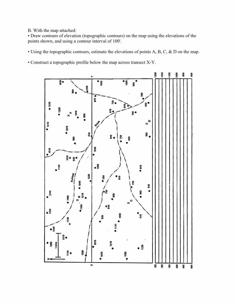
B. With the map attached: • Draw contours of elevation (topographic contours) on the map using the elevations of the points shown, and using a contour interval of 100'. • Using the topographic contours, estimate the elevations of points A, B, C, & D on the map. • Construct a topographic profile below the map across transect X-Y.
UD
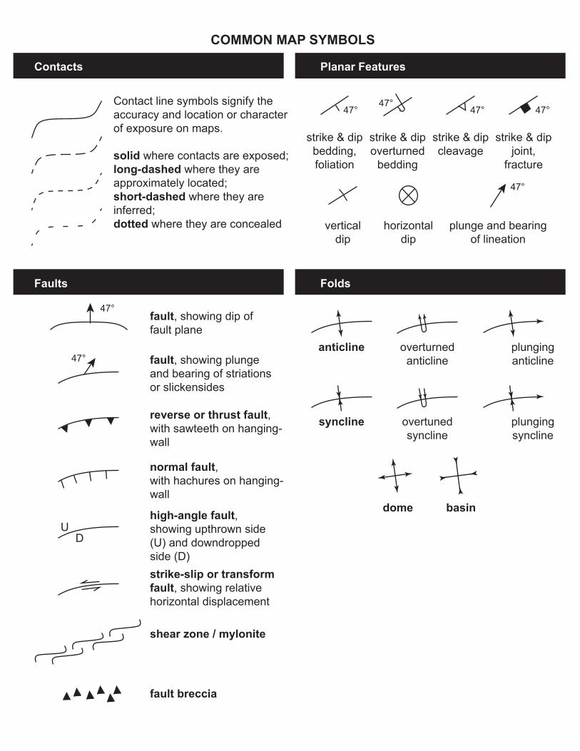
COMMON MAP SYMBOLS
Contacts Planar Features
FoldsFaults
Contact line symbols signify the accuracy and location or character of exposure on maps.
solid where contacts are exposed;long-dashed where they are approximately located;short-dashed where they are inferred;dotted where they are concealed
reverse or thrust fault, with sawteeth on hanging-wall
normal fault,with hachures on hanging-wall
high-angle fault,showing upthrown side (U) and downdropped side (D)strike-slip or transform fault, showing relative horizontal displacement
shear zone / mylonite
fault breccia
fault, showing dip offault plane
fault, showing plungeand bearing of striationsor slickensides
verticaldip
horizontaldip
plunge and bearingof lineation
anticline overturnedanticline
plunginganticline
syncline overtunedsyncline
plungingsyncline
dome basin
47°
47°
strike & dipbedding,foliation
47°
strike & dipoverturned
bedding
47°
strike & dipcleavage
47°
strike & dipjoint,
fracture
47°
47°
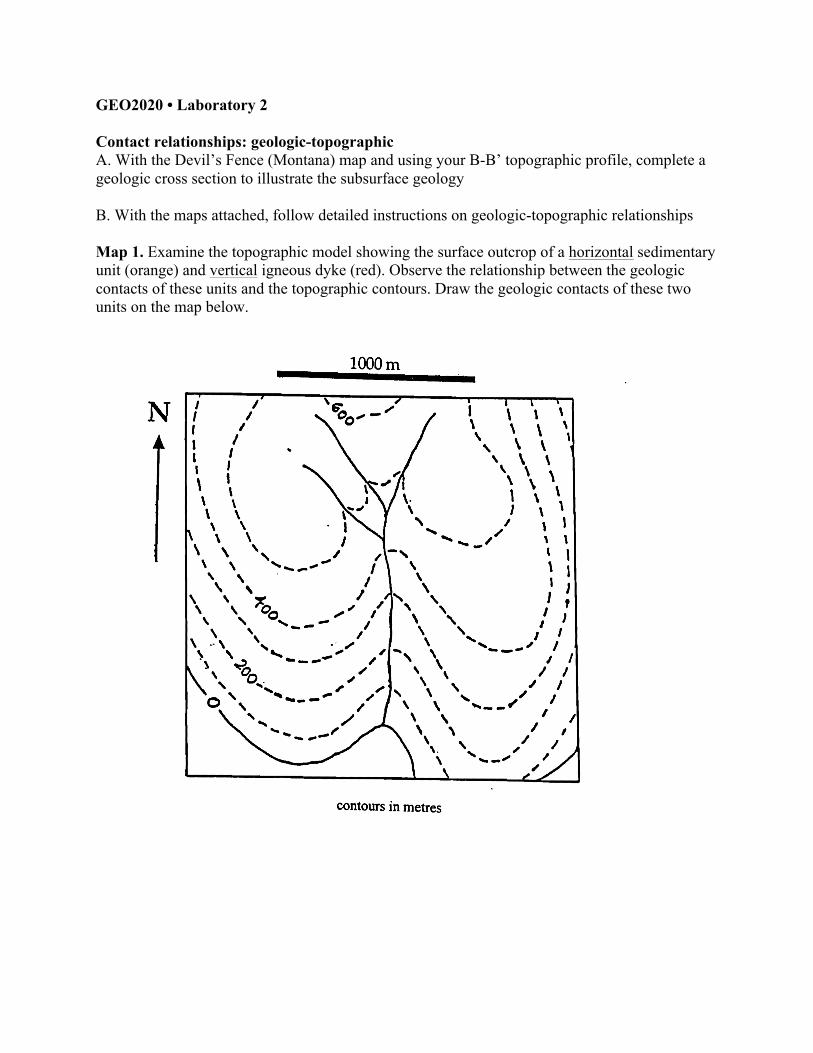
GEO2020 • Laboratory 2 Contact relationships: geologic-topographic A. With the Devil’s Fence (Montana) map and using your B-B’ topographic profile, complete a geologic cross section to illustrate the subsurface geology B. With the maps attached, follow detailed instructions on geologic-topographic relationships Map 1. Examine the topographic model showing the surface outcrop of a horizontal sedimentary unit (orange) and vertical igneous dyke (red). Observe the relationship between the geologic contacts of these units and the topographic contours. Draw the geologic contacts of these two units on the map below.
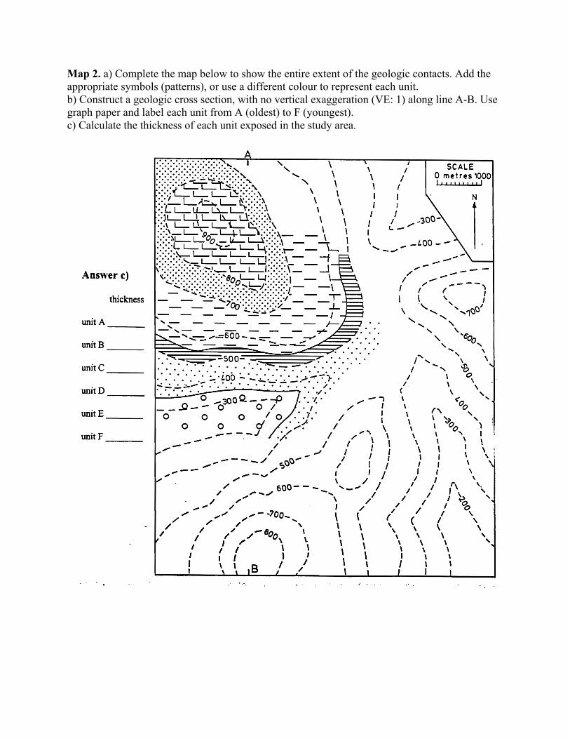
Map 2. a) Complete the map below to show the entire extent of the geologic contacts. Add the appropriate symbols (patterns), or use a different colour to represent each unit. b) Construct a geologic cross section, with no vertical exaggeration (VE: 1) along line A-B. Use graph paper and label each unit from A (oldest) to F (youngest). c) Calculate the thickness of each unit exposed in the study area.

Map 3. Examine the topographic model showing the surface outcrop of a sedimentary unit dipping upstream. Observe the relationship between the geologic contacts of this unit and the topographic contours. Draw the geologic contacts of this unit on the map below. Draw strike lines for the upper contact of the sedimentary unit.
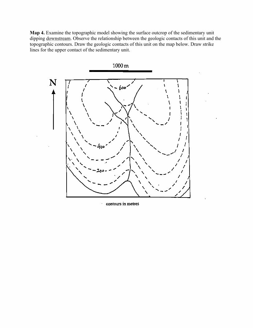
Map 4. Examine the topographic model showing the surface outcrop of the sedimentary unit dipping downstream. Observe the relationship between the geologic contacts of this unit and the topographic contours. Draw the geologic contacts of this unit on the map below. Draw strike lines for the upper contact of the sedimentary unit.
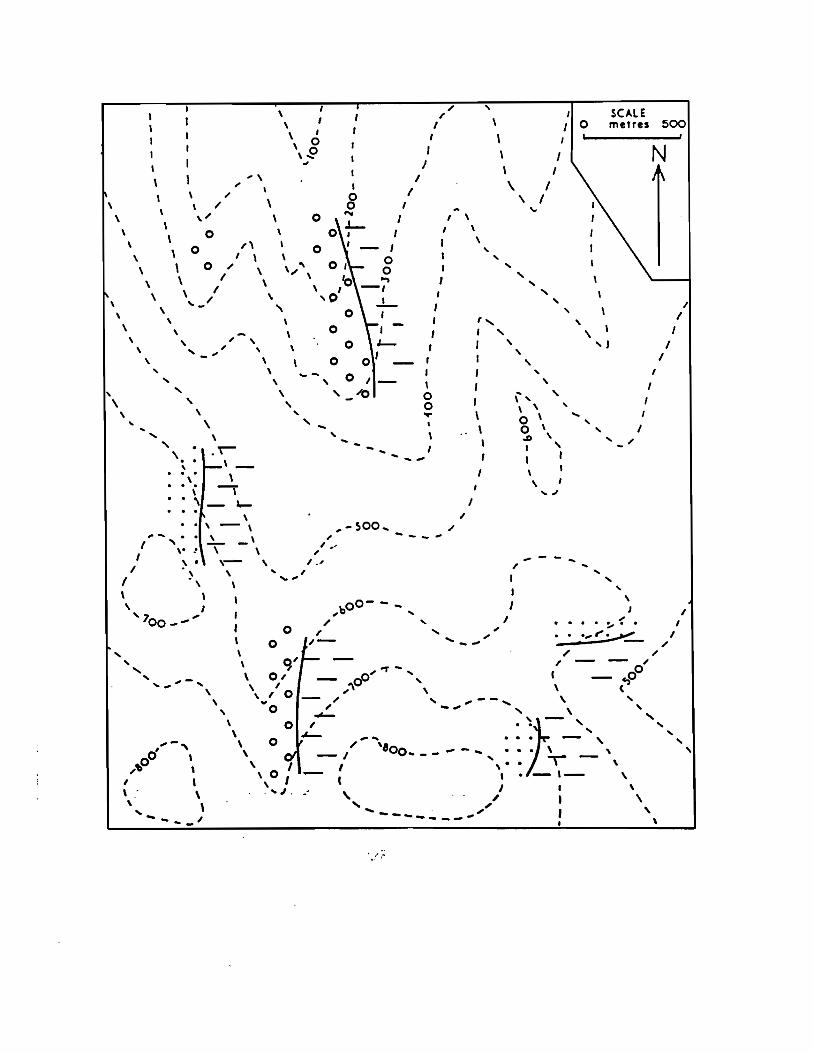
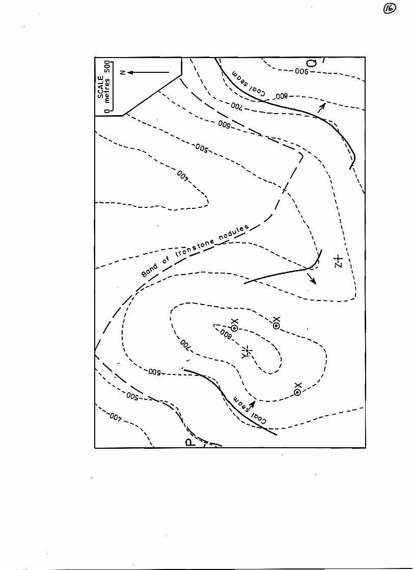
GEO2020 • Laboratory 3 Three-point problems A. See each map for detailed instructions on geologic contact-strike line relationships Problem 1. A thin coal seam (bed 1) outcrops at points A, B, and C on the map below. A second coal seam (bed 2) occurs 200 m below bed 1. a) After plotting strike lines, draw the surface trace of bed 1 throughout its extent on the map. b) Determine the strike and dip of the bed. c) Determine the depth of bed 1 in a vertical drill hole at point D. d) Determine if bed 2 outcrops at the surface in the region. If yes, draw its surface trace on the map. e) Construct a geologic cross-section showing the distribution of the coal beds along line X-Y. Problem 2. A drill hole at point A on the map below intersects a coal seam (bed 1) at a depth of 50 m and a second coal seam (bed 2) at a depth of 450 m. Drill holes B and C intersect bed 2 at 150 m and 250m depth, respectively. a) After plotting strike lines, draw surface traces on the two beds in the map area. b) Determine the strike and dip of these beds. c) Draw with a shaded pattern the extent of the upper coal seam where it is at a depth of 50 m or less. Problem 3. Three sedimentary rock units inclined in the same direction and parallel to each other occur in the map are below: unit A is conglomerate; unit B is shale; unit C is sandstone. a) After plotting strike lines, draw the surface traces of the geologic contacts throughout the map area. b) Determine the strike and dip of these parallel contacts. c) Outline the examples of an erosional remnant (outlier, or klippe) in red, and an erosional window (inlier, fenster) in blue. d) Draw a cross section along a NNE-SSW section line.


GEO2020 • Laboratory 4 Stereographic projections A. Stereographic projections - Freehand Exercise 1. plot the numeric values for the geologic planes or lineations: a) on the map (square box), using conventional symbols b) freehand on the stereogram (round circle), using grand circles or points North is to the top of the page for both map and stereogram bedding plane 030°/20°W
joint plane 030°/70°W
cleavage plane 140°/40°E
bedding plane 220°/90°

fold axis (lineation) 10°-290°
mineral lineation 70°-120°
Exercise 2. Convert the grand circles or points on the stereograms: a) into appropriate symbols on the maps (square box) b) into numeric values for the geologic planes or lineations

Exercise 3. Using your experiences, respond to the following questions: a) How do you plots of steeply inclined geologic planes differ from those of gently inclined planes on a stereogram? b) How do plots of steeply inclined geologic lineations differ from those of gently inclined lineations on a stereogram? c) How can the strike of a geologic plane be determined from a grand circle on a stereogram?

Exercise 4. A bedding surface has an orientation of 080/60S. a) Represent this surface on the map, using the conventional symbol, and on the stereogram with a grand circle (labeled S). b) What is the plunge direction of a pole normal to the 080/60S plane (that is, a line perpendicular to this plane). c) Plot this pole as a point (n) on the stereogram. bedding plane 080°/60°S
Exercise 5. A geologic plane has an orientation of 124°/40°SW. a) Represent this plane on the map using the conventional symbol, and on the stereogram using a grand circle (P). b) Represent on the stereogram the following lines: - strike (s) - a lineation (t) within the plane 124°/40°SW that plunges with a direction of 180° - a lineation (u) with the plane 124°/40°SW that plunges with a direction of 40° fault plane 124°/40°SW
Exercise 6. A geologic lineation has an orientation of 30°-300°. a) Represent this lineation on the map using the appropriate symbol, and on the stereogram using a point (l). b) Represent on the stereogram the position of this lineation(l’) after undergoing a rotation of 90° (in a clockwise direction around a vertical axis). stretching lineation 30°-300°
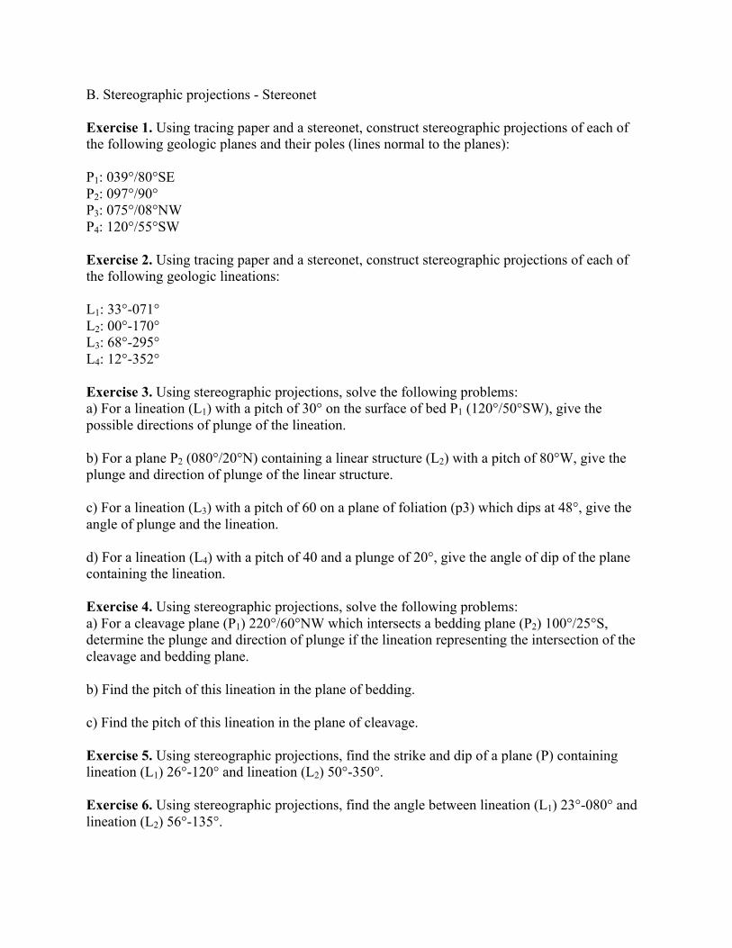
B. Stereographic projections - Stereonet Exercise 1. Using tracing paper and a stereonet, construct stereographic projections of each of the following geologic planes and their poles (lines normal to the planes): P1: 039°/80°SE P2: 097°/90° P3: 075°/08°NW P4: 120°/55°SW Exercise 2. Using tracing paper and a stereonet, construct stereographic projections of each of the following geologic lineations: L1: 33°-071° L2: 00°-170° L3: 68°-295° L4: 12°-352° Exercise 3. Using stereographic projections, solve the following problems: a) For a lineation (L1) with a pitch of 30° on the surface of bed P1 (120°/50°SW), give the possible directions of plunge of the lineation. b) For a plane P2 (080°/20°N) containing a linear structure (L2) with a pitch of 80°W, give the plunge and direction of plunge of the linear structure. c) For a lineation (L3) with a pitch of 60 on a plane of foliation (p3) which dips at 48°, give the angle of plunge and the lineation. d) For a lineation (L4) with a pitch of 40 and a plunge of 20°, give the angle of dip of the plane containing the lineation. Exercise 4. Using stereographic projections, solve the following problems: a) For a cleavage plane (P1) 220°/60°NW which intersects a bedding plane (P2) 100°/25°S, determine the plunge and direction of plunge if the lineation representing the intersection of the cleavage and bedding plane. b) Find the pitch of this lineation in the plane of bedding. c) Find the pitch of this lineation in the plane of cleavage. Exercise 5. Using stereographic projections, find the strike and dip of a plane (P) containing lineation (L1) 26°-120° and lineation (L2) 50°-350°. Exercise 6. Using stereographic projections, find the angle between lineation (L1) 23°-080° and lineation (L2) 56°-135°.
Geo2020 • Laboratory 5 Analysis of Geologic Maps
Block diagram sketches showing the different kinds of faults
Hanging-wall
block
Foot-wall
block
Hanging-wall
block
Foot-wall
block
Dip-slip faults
Strike-slip faults
Oblique-slip faults
NORMAL REVERSE
RIGHT-LATERAL(DEXTRAL)
LEFT LATERAL(SINISTRAL)
DEXTRAL/NORMAL
SINISTRAL/NORMAL
SINISTRAL/REVERSE
DEXTRAL/REVERSE
SCISSORS FAULT
Pivot

Map 1. Several units (A to F) of sedimentary rock are exposed at the surface in a map area. The units dip in the same direction, have constant thicknesses, and are parallel to each other. a) After plotting strike lines, determine the strike and dip of the geologic contacts between the different units on the map. b) Calculate the real thickness of units B, C, D, and E. c) Outline examples of erosional outliers (red) and erosional inliers (blue). d) Construct three geologic cross sections showing the real or apparent dips of the geological contacts along the lines A-B, M-N, and Y-Z. Find these dips using stereographic projections (include your answers on tracing paper).


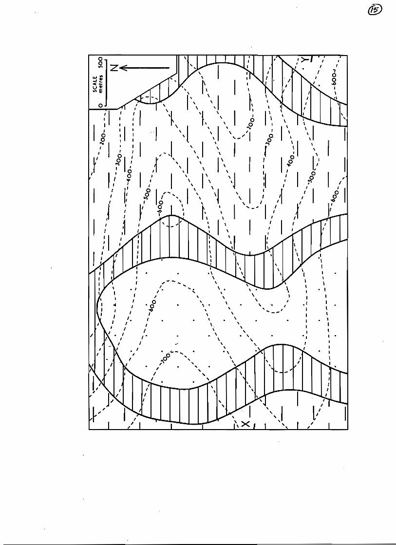
Map 2. Three sedimentary rock units are exposed at the surface in a map area; a sandstone unit (dotted pattern), a shale unit (solid lines), and a mudstone unit (broken lines) The units have been deformed (folded) by tectonic movements but remain constant in thickness and parallel to each other. a) After plotting strike lines for the lower and upper contacts of the shale unit, determine the strike and dip of these geologic contacts. b) Calculate the real thickness of the shale unit. c) Construct a geologic cross section showing the real or apparent dips of the geological contacts along line X-Y. d) Using conventional symbols, draw on the map the surface trace of the axial plane of an anticline and that of a syncline.
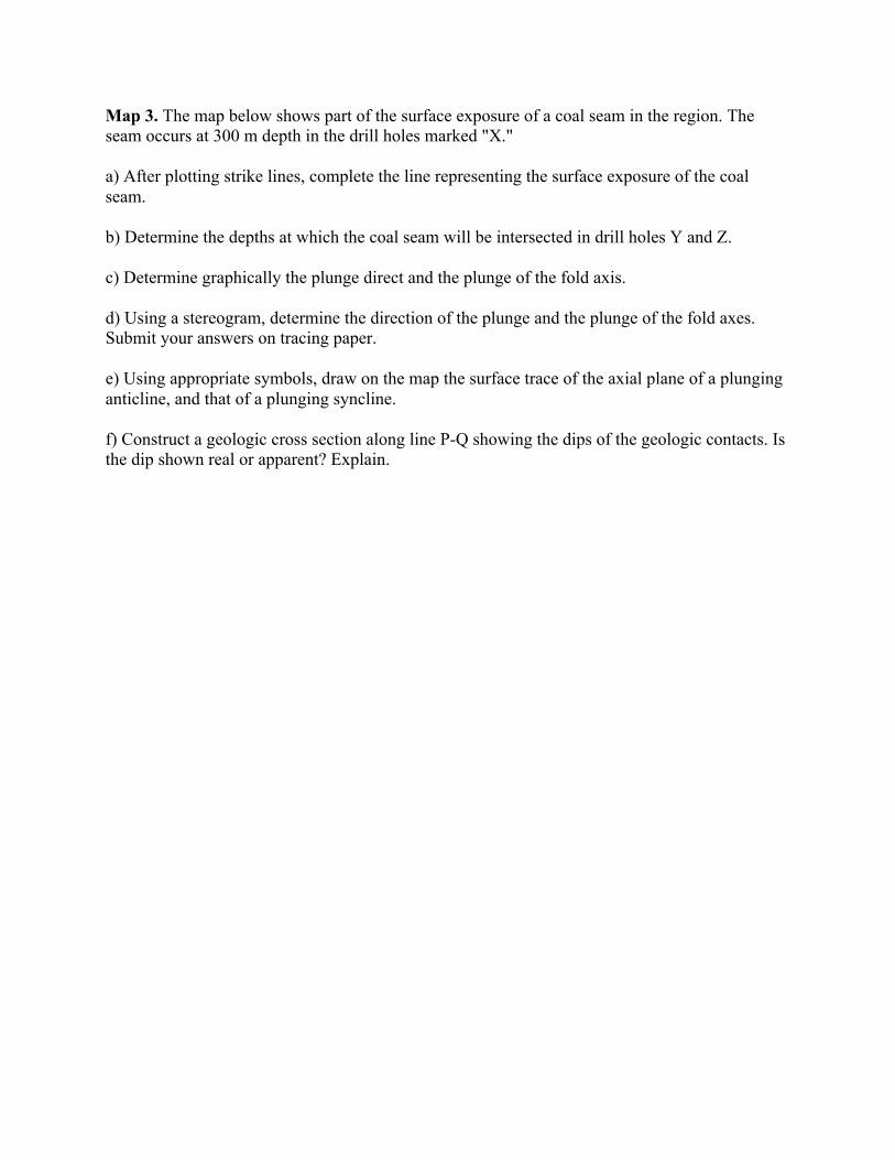
Map 3. The map below shows part of the surface exposure of a coal seam in the region. The seam occurs at 300 m depth in the drill holes marked "X." a) After plotting strike lines, complete the line representing the surface exposure of the coal seam. b) Determine the depths at which the coal seam will be intersected in drill holes Y and Z. c) Determine graphically the plunge direct and the plunge of the fold axis. d) Using a stereogram, determine the direction of the plunge and the plunge of the fold axes. Submit your answers on tracing paper. e) Using appropriate symbols, draw on the map the surface trace of the axial plane of a plunging anticline, and that of a plunging syncline. f) Construct a geologic cross section along line P-Q showing the dips of the geologic contacts. Is the dip shown real or apparent? Explain.

Map 4. A coal seam occurs in a map area at the contact between two sedimentary rock units: a sandstone unit (dotted pattern) and a mudstone unit (broken lines). A shale unit (solid lines) is also present in the area. All of the units have constant thickness, are inclined in one direction, and are parallel to each other. Line F-F represents the surface trace of a fault plane with vertical displacement. a) After plotting strike lines, determine the strike and dip of the coal seam. b) Calculate the real thickness of the sandstone unit. c) Mark on the map which block forms the hanging wall and which the footwall. Identify the the of fault. Determine the strike and dip of the fault plane. d) Construct a geologic cross-section along the line X-Y.
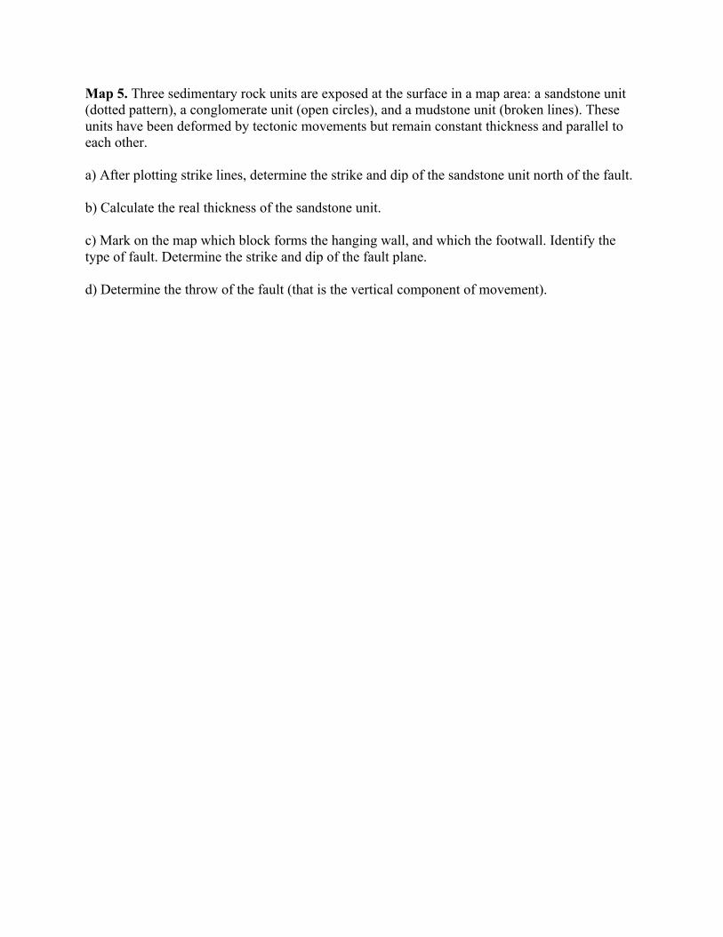
Map 5. Three sedimentary rock units are exposed at the surface in a map area: a sandstone unit (dotted pattern), a conglomerate unit (open circles), and a mudstone unit (broken lines). These units have been deformed by tectonic movements but remain constant thickness and parallel to each other. a) After plotting strike lines, determine the strike and dip of the sandstone unit north of the fault. b) Calculate the real thickness of the sandstone unit. c) Mark on the map which block forms the hanging wall, and which the footwall. Identify the type of fault. Determine the strike and dip of the fault plane. d) Determine the throw of the fault (that is the vertical component of movement).
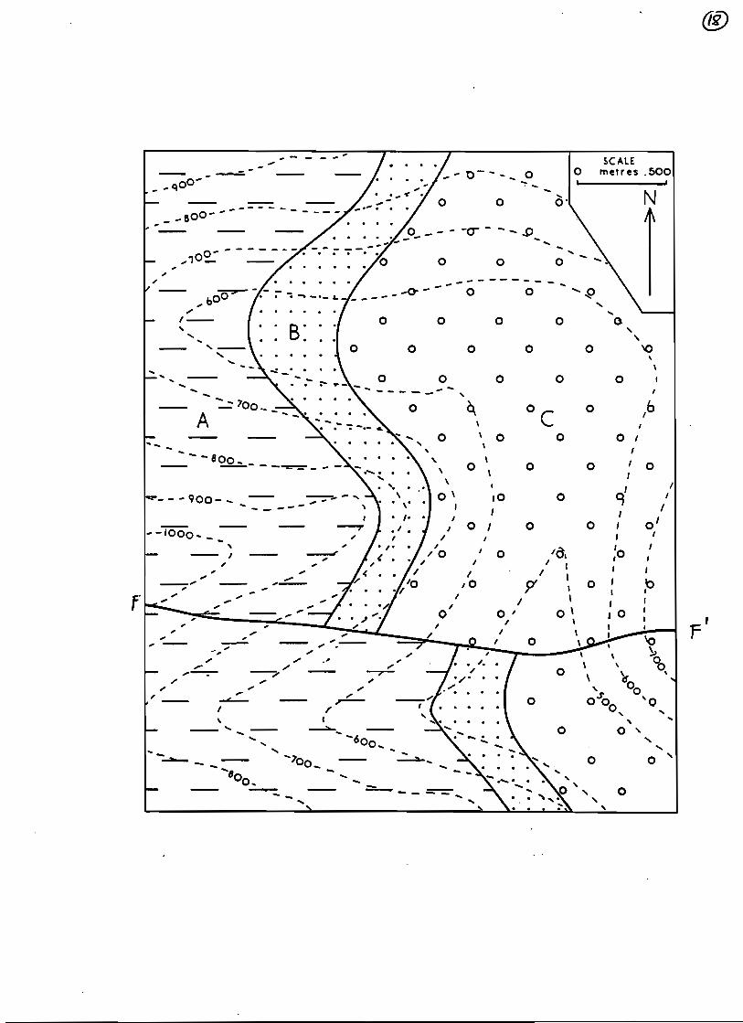
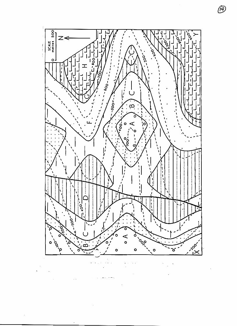
Map 6. Several sedimentary rock units (A-H) are exposed at the surface in a map area. The units have been deformed by tectonic movements (folding, faulting) but remain constant in thickness and parallel to each other. An unconformity with a planar erosional surface is also present. a) After plotting strike lines, draw the axial traces of all the folds on the map, using conventional symbols. b) Determine the strike and dip of contact C/D in the area west of the fault. c) Determine the strike and dip of the contact F/G in the eastern part of the map. d) Determine the strike and dip of the unconformity. e) Mark on the map which block forms the hanging wall and which the footwall. Identify the type of fault. Determine the strike and dip of the fault plane. f) Calculate the real thickness of units B and C. g) Summarize, in point form, the geologic history of the region (that is provide a chronological summary from oldest to youngest of events such as deposition, erosion, faulting, folding). h) Construct a geologic cross section along the line X-Y
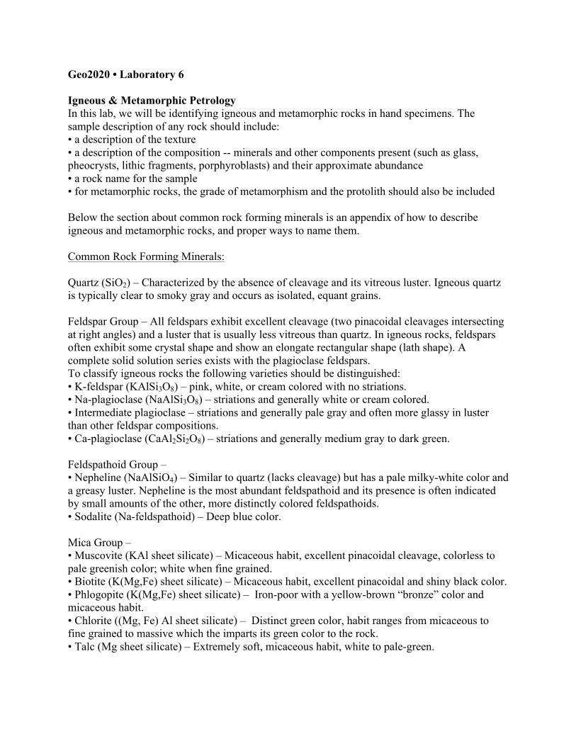
Geo2020 • Laboratory 6 Igneous & Metamorphic Petrology In this lab, we will be identifying igneous and metamorphic rocks in hand specimens. The sample description of any rock should include: • a description of the texture • a description of the composition -- minerals and other components present (such as glass, pheocrysts, lithic fragments, porphyroblasts) and their approximate abundance • a rock name for the sample • for metamorphic rocks, the grade of metamorphism and the protolith should also be included Below the section about common rock forming minerals is an appendix of how to describe igneous and metamorphic rocks, and proper ways to name them. Common Rock Forming Minerals: Quartz (SiO2) – Characterized by the absence of cleavage and its vitreous luster. Igneous quartz is typically clear to smoky gray and occurs as isolated, equant grains. Feldspar Group – All feldspars exhibit excellent cleavage (two pinacoidal cleavages intersecting at right angles) and a luster that is usually less vitreous than quartz. In igneous rocks, feldspars often exhibit some crystal shape and show an elongate rectangular shape (lath shape). A complete solid solution series exists with the plagioclase feldspars. To classify igneous rocks the following varieties should be distinguished: • K-feldspar (KAlSi3O8) – pink, white, or cream colored with no striations. • Na-plagioclase (NaAlSi3O8) – striations and generally white or cream colored. • Intermediate plagioclase – striations and generally pale gray and often more glassy in luster than other feldspar compositions. • Ca-plagioclase (CaAl2Si2O8) – striations and generally medium gray to dark green. Feldspathoid Group – • Nepheline (NaAlSiO4) – Similar to quartz (lacks cleavage) but has a pale milky-white color and a greasy luster. Nepheline is the most abundant feldspathoid and its presence is often indicated by small amounts of the other, more distinctly colored feldspathoids. • Sodalite (Na-feldspathoid) – Deep blue color. Mica Group – • Muscovite (KAl sheet silicate) – Micaceous habit, excellent pinacoidal cleavage, colorless to pale greenish color; white when fine grained. • Biotite (K(Mg,Fe) sheet silicate) – Micaceous habit, excellent pinacoidal and shiny black color. • Phlogopite (K(Mg,Fe) sheet silicate) – Iron-poor with a yellow-brown “bronze” color and micaceous habit. • Chlorite ((Mg, Fe) Al sheet silicate) – Distinct green color, habit ranges from micaceous to fine grained to massive which the imparts its green color to the rock. • Talc (Mg sheet silicate) – Extremely soft, micaceous habit, white to pale-green.
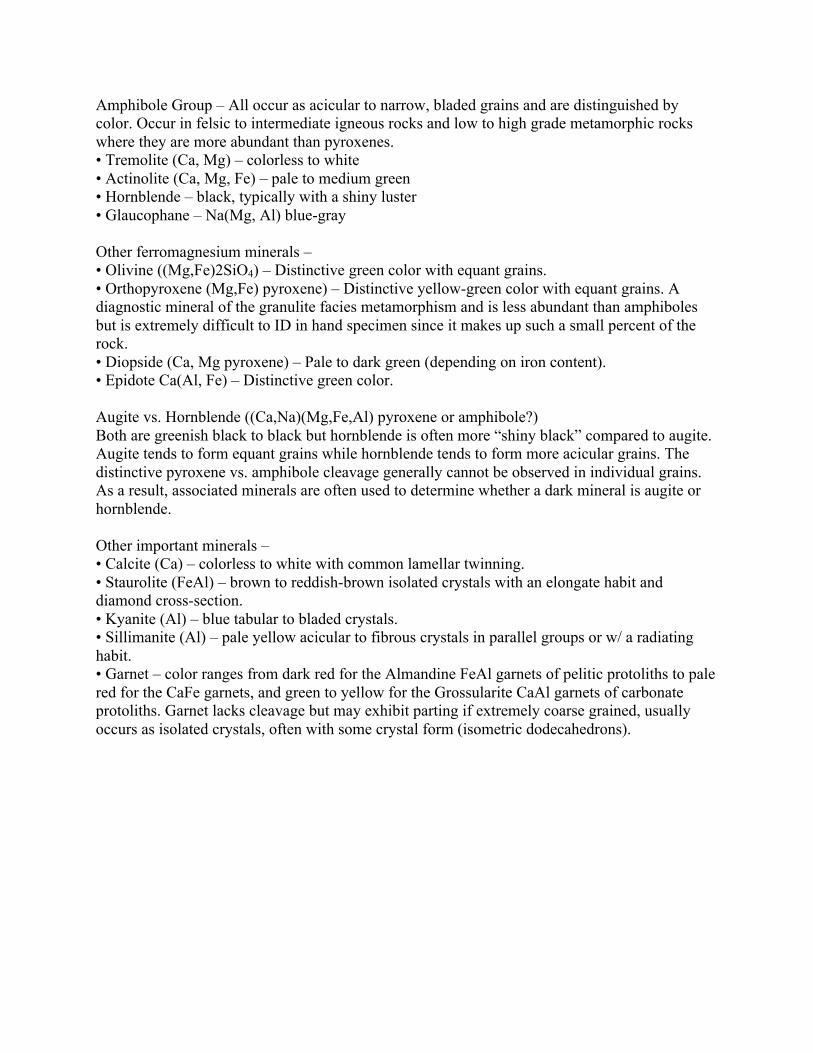
Amphibole Group – All occur as acicular to narrow, bladed grains and are distinguished by color. Occur in felsic to intermediate igneous rocks and low to high grade metamorphic rocks where they are more abundant than pyroxenes. • Tremolite (Ca, Mg) – colorless to white • Actinolite (Ca, Mg, Fe) – pale to medium green • Hornblende – black, typically with a shiny luster • Glaucophane – Na(Mg, Al) blue-gray Other ferromagnesium minerals – • Olivine ((Mg,Fe)2SiO4) – Distinctive green color with equant grains. • Orthopyroxene (Mg,Fe) pyroxene) – Distinctive yellow-green color with equant grains. A diagnostic mineral of the granulite facies metamorphism and is less abundant than amphiboles but is extremely difficult to ID in hand specimen since it makes up such a small percent of the rock. • Diopside (Ca, Mg pyroxene) – Pale to dark green (depending on iron content). • Epidote Ca(Al, Fe) – Distinctive green color. Augite vs. Hornblende ((Ca,Na)(Mg,Fe,Al) pyroxene or amphibole?) Both are greenish black to black but hornblende is often more “shiny black” compared to augite. Augite tends to form equant grains while hornblende tends to form more acicular grains. The distinctive pyroxene vs. amphibole cleavage generally cannot be observed in individual grains. As a result, associated minerals are often used to determine whether a dark mineral is augite or hornblende. Other important minerals – • Calcite (Ca) – colorless to white with common lamellar twinning. • Staurolite (FeAl) – brown to reddish-brown isolated crystals with an elongate habit and diamond cross-section. • Kyanite (Al) – blue tabular to bladed crystals. • Sillimanite (Al) – pale yellow acicular to fibrous crystals in parallel groups or w/ a radiating habit. • Garnet – color ranges from dark red for the Almandine FeAl garnets of pelitic protoliths to pale red for the CaFe garnets, and green to yellow for the Grossularite CaAl garnets of carbonate protoliths. Garnet lacks cleavage but may exhibit parting if extremely coarse grained, usually occurs as isolated crystals, often with some crystal form (isometric dodecahedrons).
Appendix 3: Igneous Rocks
Description and Nomenclature of Igneous Rocks The following properties and features are important in the description of igneous rocks in both hand specimen and thin section:
Grain size Phaneritic (Coarse): crystals visible to the naked eye
Coarse grained grains essentially > 5mm Medium grained grains 1-5mm Fine grained grains < 1mm
Aphanitic (Fine): hand lens needed Microcrystalline grains visible under the microscope Cryptocrystalline grains not distinguishable microscopically but crystallinity
indicated by such methods as X-ray Glassy essentially amorphous, no crystalline structure distinguishable
Include here any description about range or variation in grain size, e.g. porphyritic texture.
Average colour Colour can also be defined according to a colour index, which is the volume percentage M of the mafic minerals present:
M100-90: Ultramafic M90-65: Melanocratic M65-35: Mesocratic M35-0: Leucocratic
Crystallinity Wholly, partly, or non-crystalline (may be glassy). This should also include a description of crystal shape and size, including variations, as well as the proportion of glass, if any.
Holocrystalline composed entirely of crystalline grains Hypocrystalline composed partly of crystalline grains and partly of glass
(essentially a porphyritic glass) Holohyaline composed of glass
Fabric Does the rock have any obvious arrangement or pattern of its constituent minerals? The rock may be streaky, layered, banded, laminated, lineated or contain inclusions. Characteristic textures of volcanic rocks are vesicular, amygdaloidal, porphyritic, streaky, and graded (as in pyroclastic rocks). Characteristic textures of intrusive rocks are equigranular, porphyritic, drusy, granophyric, pegmatitic, ophitic, layered, laminated, veined, xenolithic.
Definitions:
Vesicular: abundance of vesicles (vacuoles or gas bubbles) which may be spherical or elongate because of compaction or flow.
Amygdaloidal: containing many amygdales (vesicles filled with secondary minerals).
Porphyritic: large crystals (phenocrysts), often euhedral, in a groundmass (matrix, mesostasis) of either much smaller crystals or glass. Druse (drusy cavity): an irregular cavity, such as a steam hole in a lava, or in a vein, whose walls are encrusted with projecting minerals, generally the same minerals as those of the enclosing rock.
Granophyric: irregular intergrowths of one mineral in another: commonly threads, patches and blebs of quartz in a base of feldspars.
Pegmatitic: exceptionally coarse grained. Pegmatites occur as discrete small bodies (e.g. dykes), or as patches or veins in host rock of similar composition. Commonly understood to form from residual magma greatly enriched in volatiles. Ophitic: euhedral or subhedral laths of plagioclase enclosed in pyroxene crystals (typically augite); occasionally referred to as doleritic.

Mineralogy List all the minerals you can identify from cleavage, habit, colour, lustre, twinning, hardness etc., and estimate their relative amounts.
1. Primary Minerals – those crystallizing directly from magma a. Essential Minerals – minerals which determine the ‘root name of the rock’.
b. Characterizing Accessory Minerals – minerals whose presence modifies the root name.
c. Minor Accessory Minerals – minerals whose presence do not affect the name of the rock.
d. Colour – depends on both grain size and mineral content. The terms leucocratic, mesocratic and melanocratic are used for light, medium and dark coloured rocks.
e. Texture – mineral textures can often give the petrologist useful information: 1. zoning – indicates change in fluid composition during mineral
growth 2. exsolution – indicates subsolidus exsolution of mineral phases
during slow cooling 3. embayments – indicates phenocryst not in equilibrium with fluid,
common during volcanic eruptions 4. order of crystallisation – worked out by studying which mineral
encloses which.
2. Secondary Minerals – minerals formed by the alteration of primary minerals, or deposited after solidification of the igneous body. Common types of Secondary processes:
a. Kaolinization – alteration of alkali feldspars to clay minerals b. Saussuritization – alteration of calcic plagioclase to saussurite, a mixture
of albite and epidote minerals. It is characterized by a greasy lustre, green colour, and absence of cleavage and twinning
c Chloritization – alteration of Fe, Mg minerals to chlorite d. Serpentinization – alteration of Fe, Mg minerals to serpentine
e. Uralitization – alteration of replacement of pyroxene to amphiboles (uralite)
f. Silicification – replacement of part of the rock by secondary silica g. Propylitization – the formation is ‘propylite’, common in andesites, by:
1. alteration of plagioclase to albite + epidote 2. alteration of Fe, Mg minerals to chlorite, calcite.
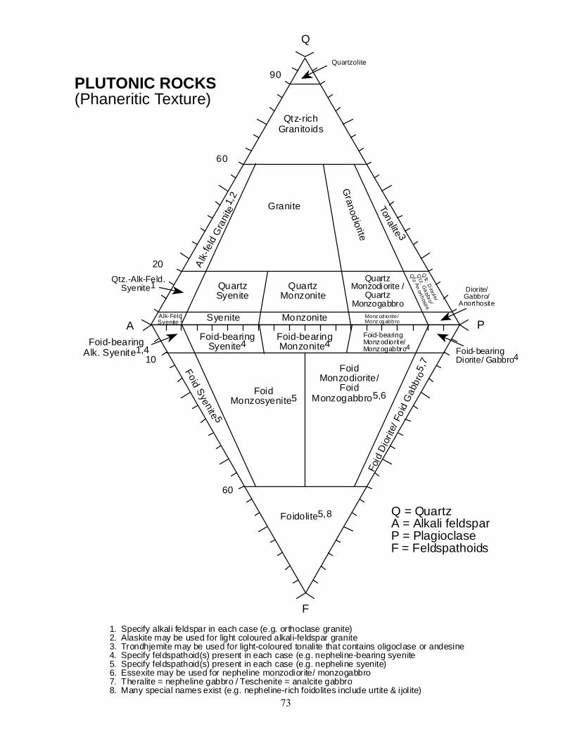
The following pages show the accepted schemes of classification and nomenclature for igneous rocks based on their mineralogical composition.
73
1. Specify alkali feldspar in each case (e.g. orthoclase granite)2. Alaskite may be used for light coloured alkali-feldspar granite3. Trondhjemite may be used for light-coloured tonalite that contains oligoclase or andesine4. Specify feldspathoid(s) present in each case (e.g. nepheline-bearing syenite5. Specify feldspathoid(s) present in each case (e.g. nepheline syenite)6. Essexite may be used for nepheline monzodiorite/ monzogabbro7. Theralite = nepheline gabbro / Teschenite = analcite gabbro8. Many special names exist (e.g. nepheline-rich foidolites include urtite & i jol ite)
Q = QuartzA = Alkali feldsparP = PlagioclaseF = Feldspathoids
PLUTONIC ROCKS(Phaneritic Texture)
A PSyenite Monzonite Monz od iorite/
Monz ogabbro
Granite
Qtz-richGranitoids
Granod io rite
Tona lite 3
Alk-
feld
Gra
nite
1,2
QuartzSyenite
QuartzMonzonite
QuartzMonzodiorite /
QuartzMonzogabbro
20
60
90
Alk-FeldSyenite 1
Qtz . D
i ori te/
Qtz. G
ab bro /
Q tz Anorth osi te
Diorite/Gabbro/
Anorthosite
Quartzolite
F
10
60
Foid-bearingSyenite4
Foid-bearingMonzonite4
FoidMonzosyenite5
FoidMonzodiorite/
FoidMonzogabbro5,6
Foid-bearingMonzodiorite/Monzogabbro4 Foid-bearing
Diorite/ Gabbro4
Foid Sye nite 5Fo
id D
iorit
e/ F
oid
Gab
bro5
,7
Foidolite5,8
Foid-bearingAlk. Syenite1,4
Q
Qtz.-Alk-Feld.Syenite1
74
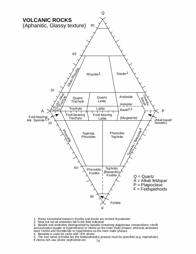
1. Rocks transitional between rhyolite and dacite are termed rhyodacites2. Most but not all andesites fall in the field indicated3. Basalts and andesites distinguished by basalts containing plagioclase compositions >An50and pyroxene (augite or hypersthene) or olivine as the main mafic phases, whereas andesiteshave <An50 and hornblende or hypersthene as the main mafic phases4. Basanite is used for rocks with >5% olivine5. The root name is foidite but the feldspathoid(s) present must be specified (e.g. nephelinite).If olivine-rich use olivine nephelinite etc.
VOLCANIC ROCKS(Aphanitic, Glassy texture)
A PTrachyte Latite
Rhyolite1Al
kal i
Rhyo
li te
QuartzTrachyte
QuartzLatite
20
60
90
AlkaliTrach yte5
Tholeiitic
Basalt
F
10
60
Foid-bearingTrachyte
Foid-bearingLatite
TephriticPhonolite
PhonoliticTephrite
(Alkali basalt/Hawaiite)
Phonol iteTe
phrit
e / B
asan
i te4
PhonoliticFoidite
Foid-bearingAlk. Syenite1,4
Q
Qtz
.-Alka
liTr
achy
te
Dacite1
90
Andesite/
Basalt2,3
Andesite
(Mugearite)
Tephritic(Basanitic)
Foidite
Foidite
Q = QuartzA = Alkali feldsparP = PlagioclaseF = Feldspathoids

75
General modal classificationand nomenclature of theGabbroic rocks
Plagioclase
Pyroxene Olivine
Plagioclase-bearing ultramafic rocks
Olivinegabbronorite
Gabbr
onor
ite
35
65
90
Troctolite
Anorthosite
10
Modal classification andnomenclature of theorthopyroxene bearingGabbroic rocks
Plagioclase
orthopyroxene Clinopyroxene
Plagioclase-bearing pyroxenites
gabbronorite
norit
e
35
65
90
gabbro
Anorthosite
10
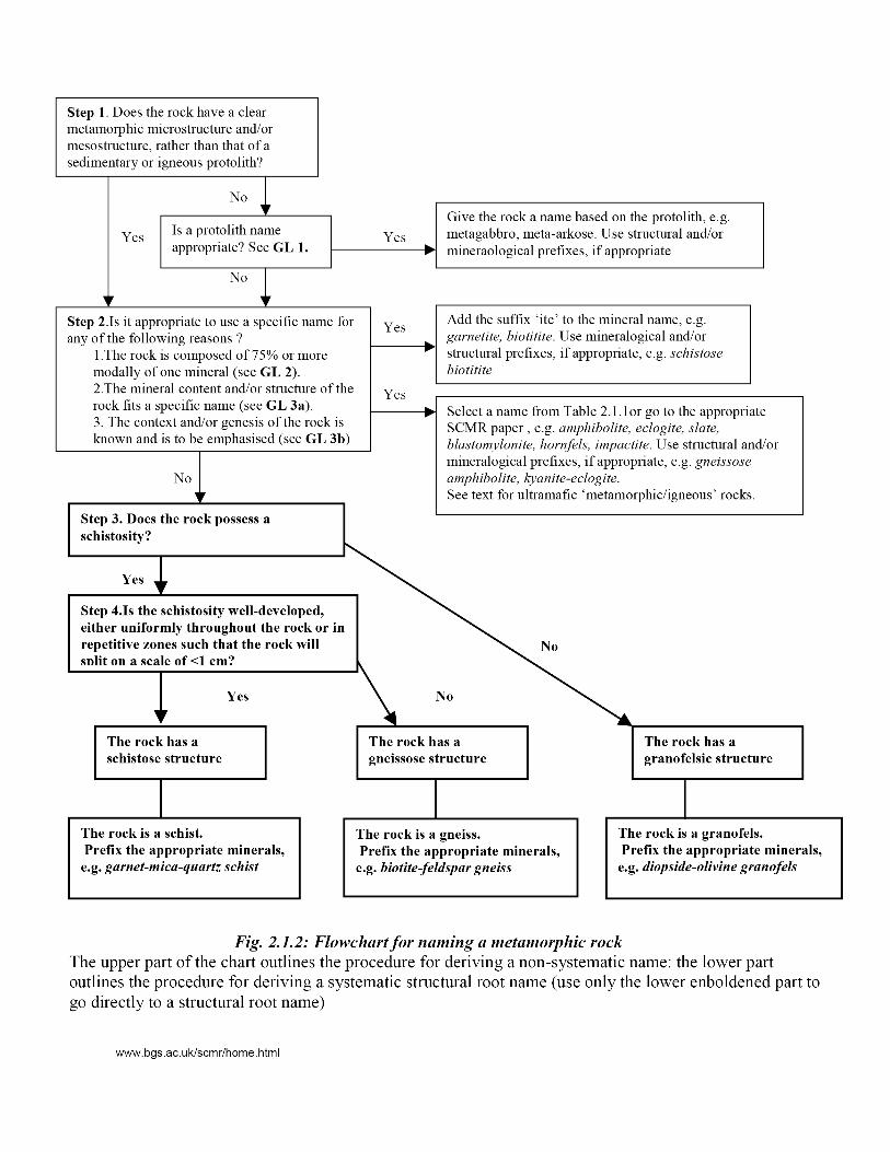
Appendix 4: Metamorphic Rocks (DJW)
4a. Studying Metamorphic Rocks In The Field Metamorphic rocks are those transformed from other rocks, and are commonly also deformed. They have a history which must be deciphered. Therefore, they need to be described in several ways:
As metamorphic rocks, with a view to determining the conditions of metamorphism. In terms of the original, pre-metamorphic rock type. In terms of the deformation processes that in many cases accompany metamorphism.
Description of metamorphic rock hand specimens Make an examination taking account of the following features:
Composition: by identifying minerals and estimating their relative proportions. Structure and microstructure on the outcrop to microscopic (hand lens) scale:
compositional layering, relict sedimentary or igneous textures, porphyroblasts, folding/microfolding, preferred orientations, penetrative or spaced cleavages.
Doing this well requires skill and experience, but a good start is made by developing good technique with a hand lens and getting plenty of practice (e.g. on laboratory practical materials).
Hand Lens Technique Which bit of the rock should I look at?
Often the first impulse is to knock a bit off and look at a fresh surface. However, fresh, broken surfaces of metamorphic rocks are commonly dark and uniform in appearance, and none too helpful. The most informative surfaces are those which have undergone some surface weathering (which etches the rock, clouds feldspar, picks out cleavages, enhances colour and texture contrasts) but which have not become coated with lichen, algae or other encrustations. In coastal outcrop, the cleanest rock can generally be found near the high-water mark. On inland exposure, try looking at the more exposed edges of outcrops, or else down near the soil level.
What's the best way to use my hand lens? Using a hand lens efficiently means reconciling two partly conflicting aims: firstly, getting a comfortably large field of view, which means putting the lens and thus the sample close to your eye, and secondly, getting as much light as possible onto the sample. So, follow these tips, or you will find hand lens work frustrating:
Put the lens up close against your eye. If you wear glasses, it's usually best to take them off.
Position yourself with the light (direct sun, ideally) coming over your shoulder onto the specimen or outcrop (your right shoulder if using your right eye). Take your hat off, assuming it's safe to do so. Nothing should block the light.
Move the specimen towards your eye until it is in focus; or, move your head towards the outcrop - don't be ashamed to grovel in pursuit of petrographic information. Don't squint or strain: relax your eyes and focus as if you're looking into the distance - the lens will do the rest.
For more specific help with metamorphic rock description, Norman Fry's Geological Society Handbook, “The Field Description of Metamorphic Rocks”, is quite comprehensive and is recommended.
4b Metamorphic rock names Although for many years there was no standard scheme for the naming of metamorphic
rocks, recommendations were published in 2007 by the IUGS Subcommission on the Systematics of Metamorphic Rocks. In practice, these largely follow existing usage, but make it easier to set out some guidelines, and a scheme for giving a rock a name (see below). Important aspects of metamorphic rocks that can be widely used for classification are:
(a) the minerals present (b) the structure of the rock (c) the nature of the rock prior to metamorphism (the protolith) (d) the genetic conditions of metamorphism (usually in terms of pressure and temperature,
with or without deformation) (e) the chemical composition of the rock.
The geologist studying metamorphic rocks may be more interested in some of these aspects than others, and it is possible for a name to reflect the focus of interest (e.g. the pre-metamorphic rock type). However, characteristics (a) and (b) can be objectively determined by field observation, and are a better choice for a general classification than terms with a genetic connotation.
Systematic names In the recommended scheme there are three root terms – schist, gneiss and granofels – that describe the overall structure of the rock, which can be modified with mineral names
Schist A medium-grained rock which is fissile (possesses a schistosity along which it will break) due to the parallel alignment of minerals
Gneiss A medium- to coarse-grained rock with a compositional layering and/or a preferred orientation of minerals (or mineral aggregates). Not fissile.
Granofels An even-grained granoblastic metamorphic rock without any obvious compositional banding or schistosity
Names of the major minerals are added in front of the root name, separated by hyphens and in order of increasing abundance e.g. biotite-quartz-plagioclase gneiss, garnet-mica-quartz schist, diopside-olivine granofels.
Specific names In many cases it will be more appropriate to use a specific rock name:
Amphibolite A rock dominantly composed of hornblende and plagioclase.
Calc-silicate rock
An impure calcareous metamorphic rock in which the dominant minerals are Ca-rich silicates
Eclogite A metabasic rock consisting mainly of garnet and omphacite (Na- and Al-rich clinopyroxene), and completely lacking in plagioclase.
Granulite Now commonly used to mean a rock with a granulite-facies mineral assemblage, particularly one of metabasic composition. In older (UK)
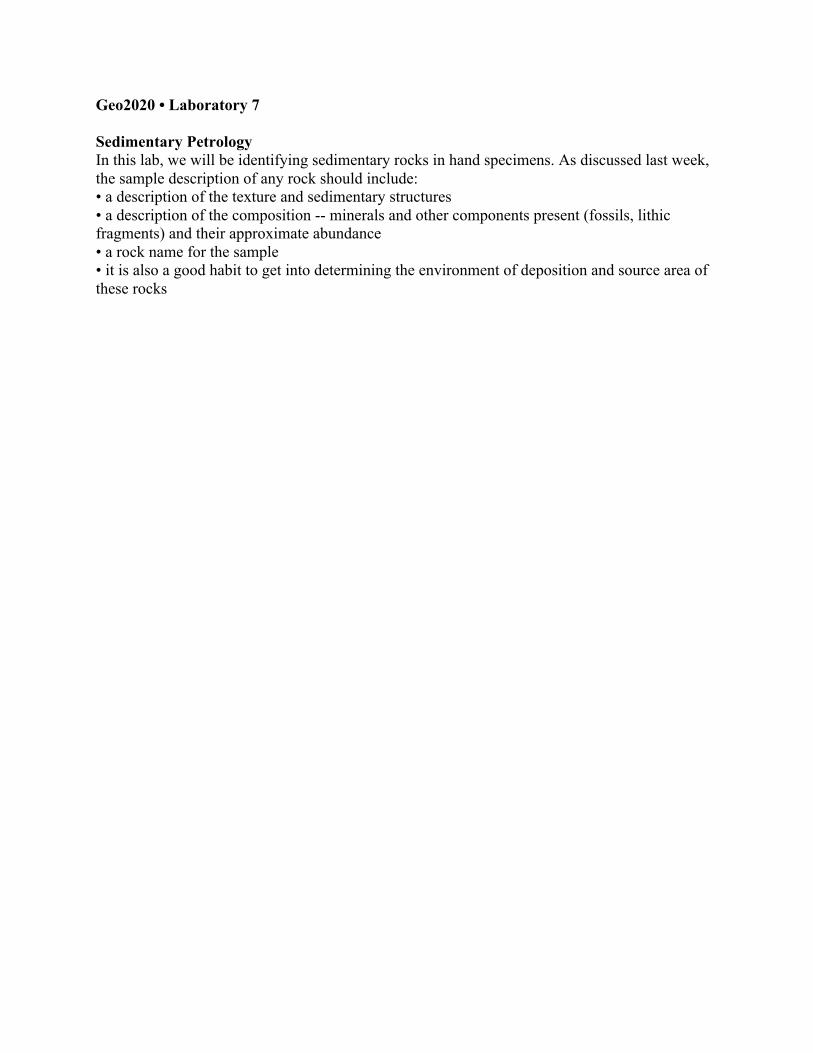
Geo2020 • Laboratory 7 Sedimentary Petrology In this lab, we will be identifying sedimentary rocks in hand specimens. As discussed last week, the sample description of any rock should include: • a description of the texture and sedimentary structures • a description of the composition -- minerals and other components present (fossils, lithic fragments) and their approximate abundance • a rock name for the sample • it is also a good habit to get into determining the environment of deposition and source area of these rocks
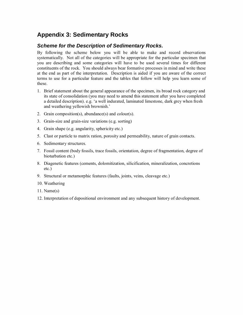
Appendix 3: Sedimentary Rocks
Scheme for the Description of Sedimentary Rocks. By following the scheme below you will be able to make and record observations systematically. Not all of the categories will be appropriate for the particular specimen that you are describing and some categories will have to be used several times for different constituents of the rock. You should always bear formative processes in mind and write these at the end as part of the interpretation. Description is aided if you are aware of the correct terms to use for a particular feature and the tables that follow will help you learn some of these.
1. Brief statement about the general appearance of the specimen, its broad rock category and its state of consolidation (you may need to amend this statement after you have completed a detailed description). e.g. ‘a well indurated, laminated limestone, dark grey when fresh and weathering yellowish brownish.’
2. Grain composition(s), abundance(s) and colour(s). 3. Grain-size and grain-size variations (e.g. sorting)
4. Grain shape (e.g. angularity, sphericity etc.) 5. Clast or particle to matrix ration, porosity and permeability, nature of grain contacts.
6. Sedimentary structures. 7. Fossil content (body fossils, trace fossils, orientation, degree of fragmentation, degree of
bioturbation etc.) 8. Diagenetic features (cements, dolomitization, silicification, mineralization, concretions
etc.) 9. Structural or metamorphic features (faults, joints, veins, cleavage etc.)
10. Weathering
11. Name(s)
12. Interpretation of depositional environment and any subsequent history of development.
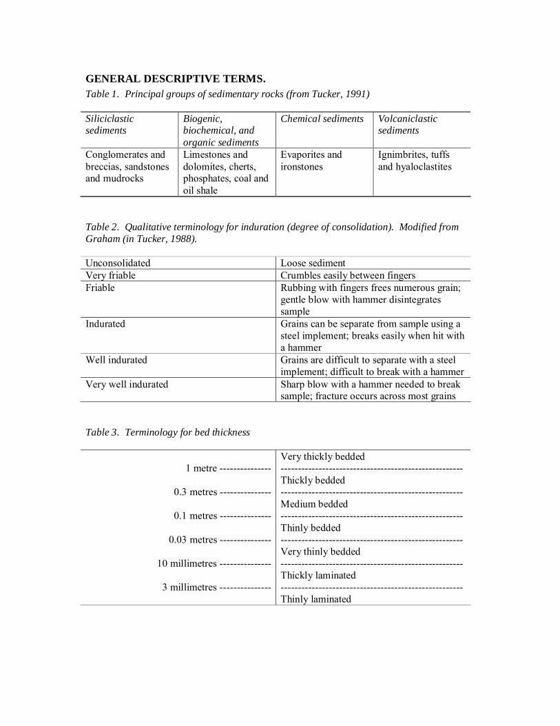
GENERAL DESCRIPTIVE TERMS. Table 1. Principal groups of sedimentary rocks (from Tucker, 1991) Siliciclastic sediments
Biogenic, biochemical, and organic sediments
Chemical sediments Volcaniclastic sediments
Conglomerates and breccias, sandstones and mudrocks
Limestones and dolomites, cherts, phosphates, coal and oil shale
Evaporites and ironstones
Ignimbrites, tuffs and hyaloclastites
Table 2. Qualitative terminology for induration (degree of consolidation). Modified from Graham (in Tucker, 1988). Unconsolidated Loose sediment Very friable Crumbles easily between fingers Friable Rubbing with fingers frees numerous grain;
gentle blow with hammer disintegrates sample
Indurated Grains can be separate from sample using a steel implement; breaks easily when hit with a hammer
Well indurated Grains are difficult to separate with a steel implement; difficult to break with a hammer
Very well indurated Sharp blow with a hammer needed to break sample; fracture occurs across most grains
Table 3. Terminology for bed thickness
Very thickly bedded 1 metre --------------- -----------------------------------------------------
Thickly bedded 0.3 metres --------------- -----------------------------------------------------
Medium bedded 0.1 metres --------------- -----------------------------------------------------
Thinly bedded 0.03 metres --------------- -----------------------------------------------------
Very thinly bedded 10 millimetres --------------- -----------------------------------------------------
Thickly laminated 3 millimetres --------------- -----------------------------------------------------
Thinly laminated

SILICICLASTIC SEDIMENTARY ROCKS. These are dominated by silicate minerals and rock fragments. Table 4. Grain-size scale for sediments and sedimentary rocks, used particularly for siliciclastics (Udden-Wentworth) mm Phi Class terms Terms implying grain
size BOULDERS ------- 256 ------- ------- -8 ------- ------------------ 128 -7 COBBLES ------- 64 ------- ------- -6 ------- ------------------ 32 -5 16 -4 PEBBLES 8 -3 ------- 4 ------- ------- -2 ------- ------------------ GRANULES
Gravel, rudite, conglomerate, breccia & rudaceous sediments
------- 2 ------- ------- -1 ------- ------------------ ----------------------------- V. Coarse 1 0 Coarse 0.5 1 S A Med. 0.25 2 N D Fine 0.125 3 V. fine
Sand, sandstone, arenites, & arenaceous sediments
------- 0.062 ------- ------- 4 ------- ------------------ ----------------------------- Coarse 0.031 5 S I Med. 0.016 6 L T Fine 0.008 7 V. fine
Silt & siltstone
------- 0.004 ------- ------- 8 ------- ------------------ ----------------------------- CLAY Clay, claystone &
argillite
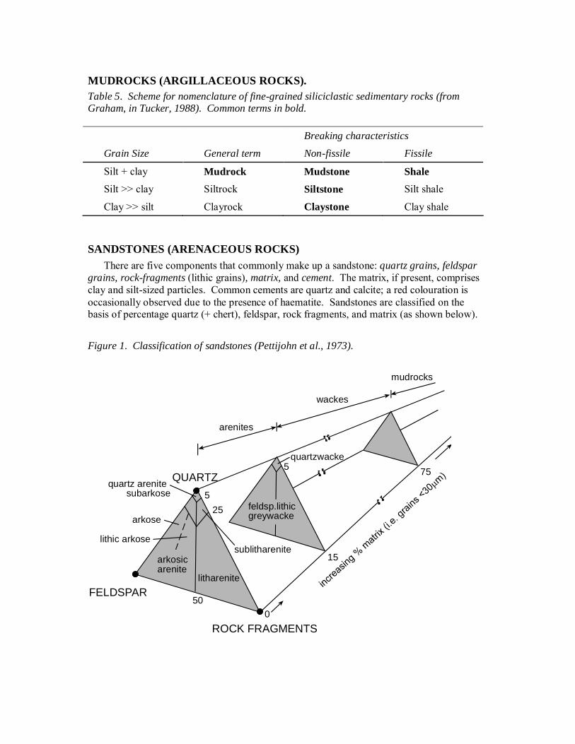
MUDROCKS (ARGILLACEOUS ROCKS). Table 5. Scheme for nomenclature of fine-grained siliciclastic sedimentary rocks (from Graham, in Tucker, 1988). Common terms in bold.
Breaking characteristics
Grain Size General term Non-fissile Fissile
Silt + clay Mudrock Mudstone Shale Silt >> clay Siltrock Siltstone Silt shale
Clay >> silt Clayrock Claystone Clay shale
SANDSTONES (ARENACEOUS ROCKS) There are five components that commonly make up a sandstone: quartz grains, feldspar
grains, rock-fragments (lithic grains), matrix, and cement. The matrix, if present, comprises clay and silt-sized particles. Common cements are quartz and calcite; a red colouration is occasionally observed due to the presence of haematite. Sandstones are classified on the basis of percentage quartz (+ chert), feldspar, rock fragments, and matrix (as shown below).
Figure 1. Classification of sandstones (Pettijohn et al., 1973).
QUARTZ
ROCK FRAGMENTS
FELDSPAR
quartz arenitesubarkose
sublitharenite
arkose
lithic arkose
arkosicarenite
litharenite
arenites
quartzwacke
wackes
mudrocks
525
50
5
0
15
75
feldsp.lithicgreywacke
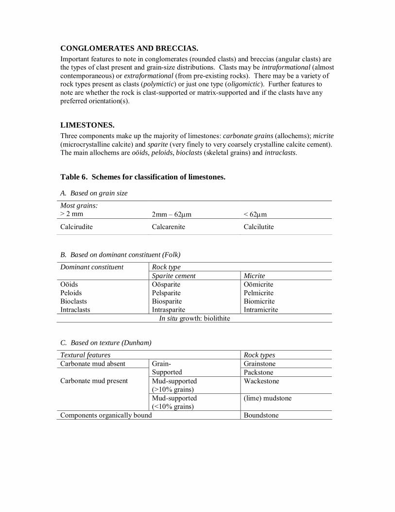
CONGLOMERATES AND BRECCIAS. Important features to note in conglomerates (rounded clasts) and breccias (angular clasts) are the types of clast present and grain-size distributions. Clasts may be intraformational (almost contemporaneous) or extraformational (from pre-existing rocks). There may be a variety of rock types present as clasts (polymictic) or just one type (oligomictic). Further features to note are whether the rock is clast-supported or matrix-supported and if the clasts have any preferred orientation(s).
LIMESTONES. Three components make up the majority of limestones: carbonate grains (allochems); micrite (microcrystalline calcite) and sparite (very finely to very coarsely crystalline calcite cement). The main allochems are oöids, peloids, bioclasts (skeletal grains) and intraclasts.
Table 6. Schemes for classification of limestones.
A. Based on grain size
Most grains: > 2 mm 2mm – 62m < 62m
Calcirudite Calcarenite Calcilutite
B. Based on dominant constituent (Folk)
Rock type Dominant constituent Sparite cement Micrite
Oöids Oösparite Oömicrite Peloids Pelsparite Pelmicrite Bioclasts Biosparite Biomicrite Intraclasts Intrasparite Intramicrite
In situ growth: biolithite
C. Based on texture (Dunham)
Textural features Rock types Carbonate mud absent Grainstone Grain-
Supported Packstone Mud-supported (>10% grains)
Wackestone Carbonate mud present
Mud-supported (<10% grains)
(lime) mudstone
Components organically bound Boundstone

ALL SEDIMENTARY ROCKS.
Table 7. Informal terms for describing rocks in which crystallinity is a key characteristic (Tucker, 1982).
2 mm Very coarsely crystalline
1 mm Coarsely crystalline
0.5 mm Medium crystalline
0.25mm Finely crystalline
0.125 mm Very finely crystalline
0.063 mm Microcrystalline
0.004 mm Cryptocrystalline
Table 8. Common sedimentary structures. (Modified from Graham, in Tucker, 1988)
Observed primarily as internal structures of beds in section: Cross-stratification
Lamination Grading Soft sediment deformation Bioturbation (general burrowing) and trace fossils Stromatolites Pedogenic horizons, hardgrounds Cavities (mainly in limestones) Concretions (whole specimen may be a concretion) Styolites (dissolution)
Observed primarily on bedding surfaces (i) Best seen on bottom surfaces (sole marks) Flute marks
Tool marks Load casts Topographic infill above bedforms
(ii) Best seen on top surfaces Bed forms (e.g. ripple, dunes, hummocks)
Shrinkage cracks Sand volcanoes Raindrop impressions
(iii) Seen on both top and bottom surfaces Trace fossils
Primary current lineation
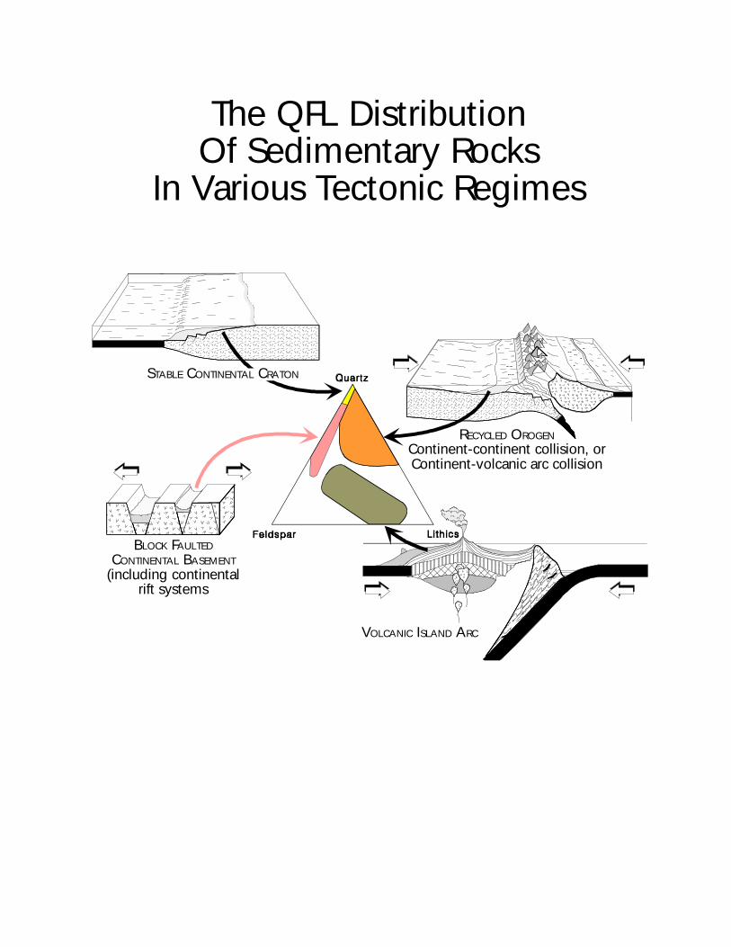
The QFL DistributionOf Sedimentary Rocks
In Various Tectonic Regimes
VOLCANIC ISLAND ARC
RECYCLED OROGEN
Continent-continent collision, orContinent-volcanic arc collision
BLOCK FAULTED
CONTINENTAL BASEMENT
(including continental rift systems
STABLE CONTINENTAL CRATON
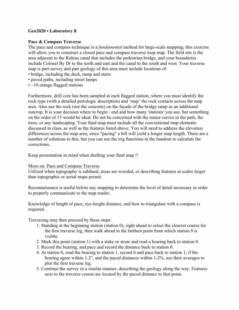
Geo2020 • Laboratory 8 Pace & Compass Traverse The pace and compass technique is a fundamental method for large-scale mapping; this exercise will allow you to construct a closed pace and compass traverse loop map. The field site is the area adjacent to the Rideau canal that includes the pedestrian bridge, and your boundaries include Colonel By Dr to the north and east and the canal to the south and west. Your traverse map is part survey and part geology of this area must include locations of: • bridge, including the deck, ramp and stairs • paved paths, including street lamps • ~10 orange flagged stations Furthermore, drill core has been sampled at each flagged station, where you must identify the rock type (with a detailed petrologic description) and ‘map’ the rock contacts across the map area. Also use the rock (not the concrete) on the façade of the bridge ramp as an additional outcrop. It is your decision where to begin / end and how many 'stations' you use, but something on the order of 15 would be ideal. Do not be concerned with the minor curves in the path, the trees, or any landscaping. Your final map must include all the conventional map elements discussed in class, as well as the features listed above. You will need to address the elevation differences across the map area, since "pacing" a hill will yield a longer map length. There are a number of solutions to this, but you can use the trig functions in the handout to calculate the corrections. Keep presentation in mind when drafting your final map !! More on: Pace and Compass Traverse Utilized when topography is subdued, areas are wooded, or describing features at scales larger than topographic or aerial maps permit. Reconnaissance is useful before any mapping to determine the level of detail necessary in order to properly communicate to the map reader. Knowledge of length of pace, eye-height distance, and how to triangulate with a compass is required. Traversing may then proceed by these steps:
1. Standing at the beginning station (station 0), sight ahead to select the clearest course for the first traverse leg, then walk ahead to the farthest point from which station 0 is visible.
2. Mark this point (station 1) with a stake or stone and read a bearing back to station 0. 3. Record the bearing, and pace and record the distance back to station 0. 4. At station 0, read the bearing to station 1, record it and pace back to station 1; if the
bearing agree within 1-2°, and the paced distances within 1-2%, use their averages to plot the first traverse leg.
5. Continue the survey in a similar manner, describing the geology along the way. Features next to the traverse course are located by the paced distance to that point.

Result may be narrow strip or closed traverse loop. Ideal traverse is unobstructed and smooth (road, trail, beach, open ridge); less ideal is streams, railroads and power lines. If elevation exists, traverse upslope.

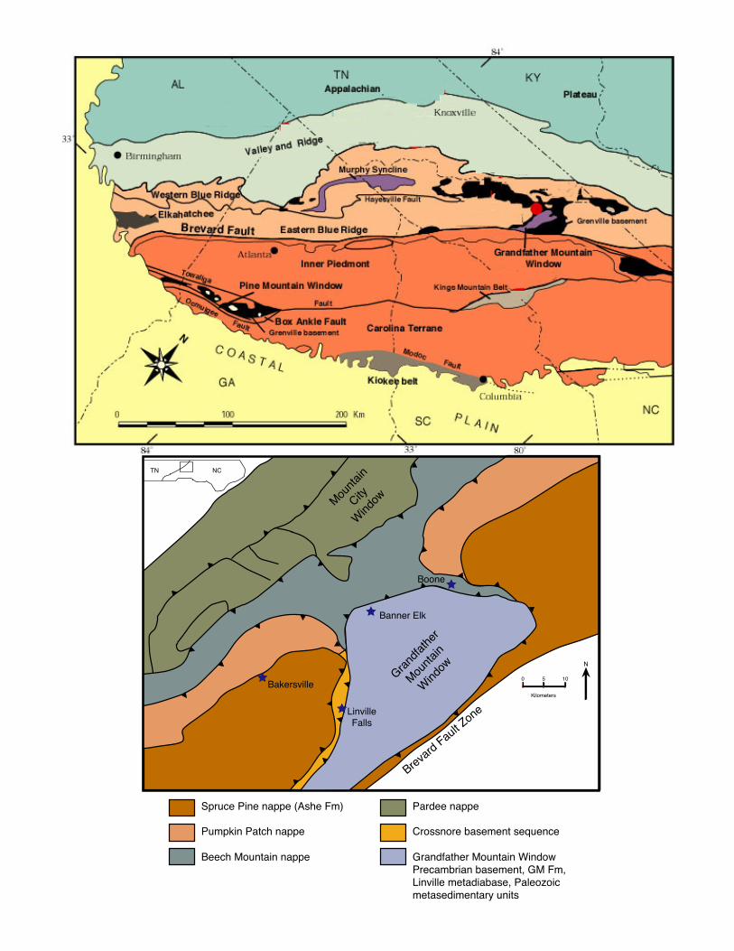
Geo2020 • Field excursion I. Stratigraphic section: Taconic – Acadian clastic wedges: You will be responsible for describing and measuring the stratigraphic section exposed along Briery Gap Run (Pendleton County, WV), which includes the clastic and carbonaceous material deposited from the Mid-Ordovician through the Late-Devonian. Only five formations of the sequence are present along the road, so on beginning of the first day, we will make brief stops to other lithologic units in the area to examine the lower portion of this section (of which you are not responsible for measuring, just describing). These units will be present in our next project area, so become familiar with them now! II. Geologic strip mapping: Valley & Ridge province: You will be responsible for producing a geologic map of Mill Creek Mountain (Hardy & Hampshire Counties., WV) that includes the carbonate sequences deposited between the Taconic and Acadian orogenies. Since this is a poorly exposed, but geographically extensive ‘mountain’, we will be utilizing the technique of strip mapping across the mountain, using existing roads and streams for outcrop availability. Your objective is to determine formation contacts and measure attitudes on bedding (and cleavage, where applicable) along three E-W transects. When we return to Ottawa, you can put the strips in a larger context on a map to determine overall structure of the mountain. Combined, you will turn in: • a scaled stratigraphic section of the measured section (part I) • geologic map(s) of Mill Creek mountain (part II) • cross-section through the mountain • stereonet of representative structural data to determine orientation of any regional structures • your field notebook which should describe in detail the field work you performed III. Geology of Grandfather Mountain window: • a succinct ~5 page write-up of your tectonic interpretation of the lithologic units. Not a road guide, but a synthesis. Draw pictures! Again, remember to include all relevant features that should be on all maps, and neatness counts!
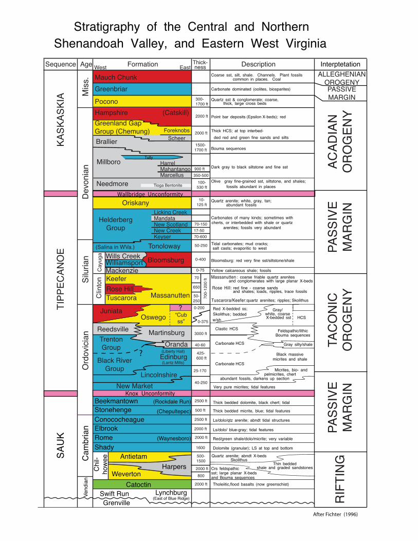
Skolithus
Oranda
350-500
(Catskill)
WilliamsportWills Creek
Tully
Wallbridge Unconformity
?
?
After Fichter (1996)
Stratigraphy of the Central and NorthernShenandoah Valley, and Eastern West Virginia
Interptetation
Knox Unconformity
Coarse sst, silt, shale. Channels. Plant fossilscommon in places. Coal
Carbonate dominated (oolites, biosparites)
Quartz sst & conglomerate; coarse,thick, large cross beds
Point bar deposits (Epsilon X-beds); red
Thick HCS; at top interbed-ded red and green fine sands and silts
Bouma sequences
Olive gray fine-grained sst, siltstone, and shales;fossils abundant in places
Dark gray to black siltstone and fine sst
Quartz arenite; white, gray, tan;abundant fossils
Carbonates of many kinds; sometimes withcherts, or interbedded with shale or quartz
arenites; fossils very abundant
Tidal carbonates; mud cracks;salt casts; evaporitic to west
Bloomsburg: red very fine sst/siltstone/shale
Yellow calcareous shale; fossilsMassanutten : coarse friable quartz arenites
and conglomerates with large planar X-beds
Tuscarora/Keefer: quartz arenites; ripples; Skolithus
Rose Hill: red fine - coarse sandsand shales; loads, ripples, trace fossils
Red X-bedded ss;; bedded
w/sh
Gray/white, coarse X-bedded sst
Clastic HCS
Black massivemicrites and shale
Feldspathic/lithicBouma sequences
Gray silty/shale
HCS
Micrites, bio- andpelmicrites, chert
abundant fossils, darkens up section
Very pure micrites; tidal features
Thick bedded dolomite, black chert; tidal
Thick bedded micrite, blue; tidal features
Ls/dolo/qtz arenite; abndt tidal structures
Ls/dolo/ blue-gray; tidal features
Red/green shale/dolo/micrite; very variable
Dolomite (granular); LS at top and bottom
Crs feldspathicsst; large planar X-bedsand Bouma sequences
Quartz arenite; abndt X-bedsSkolithus
Thin beddedshale and graded sandstones
Tholeiitic,flood basalts (now greenschist)
GrenvilleLynchburg
(East of Blue Ridge)Swift Run
Catoctin
Vend
ian
SAU
K
Cam
bria
nC
hil-
how
ee Antietam
WevertonHarpers
Beekmantown (Rockdale Run)Stonehenge (Chepultepec)ConococheagueElbrookRome (Waynesboro)Shady
Ord
ovic
ian
JuniataOswego
Reedsville Martinsburg
“Cubss”
TrentonGroup
Black RiverGroup
Edinburg(Liberty Hall)
(Lantz Mills)
LincolnshireNew Market
(Salina in WVa.) Tonoloway
Clin
ton Keefer
Rose HillTuscarora Massanutten
MackenzieBloomsburg
Cay
uga
Oriskany
HelderbergGroup
Licking CreekMandataNew ScotlandNew CreekKeyser
Mauch ChunkGreenbriar
PoconoHampshireGreenland GapGroup (Chemung) Foreknobs
ScheerBrallier
Millboro HarrelMahantangoMarcellus
Needmore Tioga Bentonite
Dev
onia
n
KASK
ASKI
A Mis
s.
TIPP
ECAN
OE
Silu
rian
Sequence Age FormationWest EastThick- Descriptionness
300-1700 ft
2000 ft
2000 ft
2000 ft
2000 ft
2000 ft
2000 ft
2500 ft
2500 ft
3000 ft
1500-1700 ft
900 ft
100-530 ft
10-125 ft
70-15017-5070-600
50-250
0-400
0-75
70
650
50-250
700-
1200
ft
0-200
0-375
40-60
425- 600 ft
25-170
40-250
500 ft
800
1600
500-1500
Carbonate HCS
RIF
TIN
GPA
SSIV
EM
ARG
INTA
CO
NIC
OR
OG
ENY
ACAD
IAN
OR
OG
ENY
ALLEGHENIANOROGENY
PASS
IVE
MAR
GIN
PASSIVEMARGIN
Carbonate HCS
N
TN NC
Grand
fath
er
Mou
ntain
Wind
ow
Mou
ntain
City
Wind
ow
Brevard Fault Z
one
Bakersville
Boone
Linville Falls
Banner Elk
0 5 10
Kilometers
Grandfather Mountain Window Precambrian basement, GM Fm, Linville metadiabase, Paleozoic metasedimentary units
Crossnore basement sequence
Pardee nappe
Beech Mountain nappe
Pumpkin Patch nappe
Spruce Pine nappe (Ashe Fm)