Embed Size (px)
Citation preview
DEPARTMENT OF EDUCATION
GEOLOGY
PUBLISHED BY FLEXIBLE OPEN AND DISTANCE EDUCATION PRIVATE MAIL BAG, P.O. WAIGANI, NCD
FOR DEPARTMENT OF EDUCATION PAPUA NEW GUINEA
2016
GRADE 10
SCIENCE
UNIT 6
GEOLOGY
Writer Selected Contract Writers Content and Language Editors Science Department Subject Content Adviser Subject Review Committee Course Format Editor Anna Liza Cale
GR 10 SCI U6 1 TITLE
GRADE 10
SCIENCE
UNIT 6
GEOLOGY
IN THIS UNIT YOU WILL LEARN ABOUT:
TOPIC 1: THE EARTH’S CRUST
TOPIC 2: ROCKS AND THEIR CLASSIFICATIONS
TOPIC 3: GEOLOGICAL ACTIVITIES
TOPIC 4: GEOLOGICAL ACTIVITIES IN PAPUA NEW GUINEA
GR 10 SCI U6 2 ISBN & ACKNOWLEDGMENT
Published in 2016 by Flexible Open and Distance Education @Copyright 2016, Department of Education, PNG All rights reserved. No part of this publication may be reproduced, stored in a retrieval system, or transmitted in any form or by any means electronic, mechanical, photocopying, recording or otherwise without prior permission from the publisher. Printed by Flexible Open and Distance Education ISBN; 978-9980-87-713-0 National Library Services of Papua New Guinea
Acknowledgements
The Grade 10 Science Unit 6 course book was written, edited and formatted by the Curriculum Division of the Flexible Open and Distance Education. Special thanks to the staff of the Science Department of FODE who played the active roles in coordinating writing workshops, outsourcing lesson writing and the editing processes. We acknowledge the professional guidance provided by teachers, educators, content advisors, representatives from non-government organisations and the Science Subject Review Committee who have developed this course book through meetings and consultations. This document was co-funded by the GoPNG and World Bank.
DEMAS TONGOGO PRINCIPAL
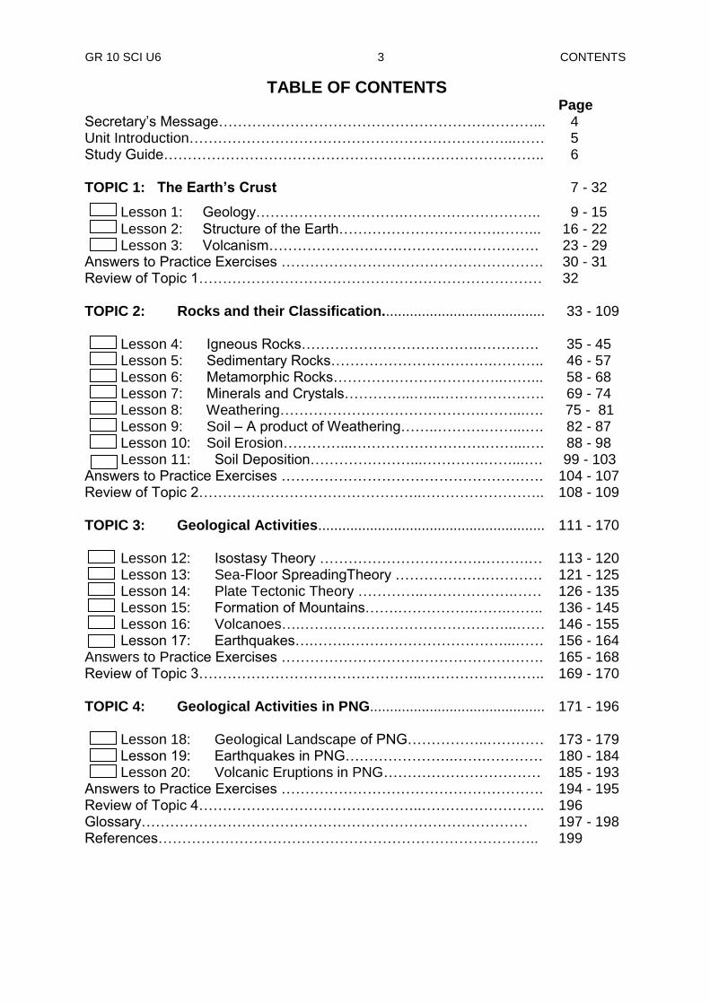
GR 10 SCI U6 3 CONTENTS
TABLE OF CONTENTS
Page Secretary‟s Message…………………………………………………………... 4 Unit Introduction…………………………………………………………...…… 5 Study Guide…………………………………………………………………….. 6
TOPIC 1: The Earth’s Crust
7 - 32
Lesson 1: Geology………………………….……………………….. 9 - 15
Lesson 2: Structure of the Earth…………………………….……... 16 - 22 Lesson 3: Volcanism…………………………………..……………. 23 - 29 Answers to Practice Exercises ………………………………………………. 30 - 31 Review of Topic 1……………………………………………………………… 32 TOPIC 2: Rocks and their Classification.........................................
33 - 109
Lesson 4: Igneous Rocks……………………………….…………. 35 - 45 Lesson 5: Sedimentary Rocks…………………………….……….. 46 - 57 Lesson 6: Metamorphic Rocks………….…………………..……... 58 - 68 Lesson 7: Minerals and Crystals…………...…...…………………. 69 - 74 Lesson 8: Weathering…………………………………….……...…. 75 - 81 Lesson 9: Soil – A product of Weathering……..……….……...…. 82 - 87 Lesson 10: Soil Erosion…………...……………………….……...…. 88 - 98 Lesson 11: Soil Deposition…………………...………….……...…. 99 - 103 Answers to Practice Exercises ………………………………………………. 104 - 107 Review of Topic 2………………………………………..…………………….. 108 - 109 TOPIC 3: Geological Activities.........................................................
111 - 170
Lesson 12: Isostasy Theory …………………………….……….… 113 - 120 Lesson 13: Sea-Floor SpreadingTheory ……………….………… 121 - 125 Lesson 14: Plate Tectonic Theory …………..……………….…… 126 - 135 Lesson 15: Formation of Mountains…….…………….…….…….. 136 - 145 Lesson 16: Volcanoes….…….………………………………...…… 146 - 155 Lesson 17: Earthquakes….…….……………………………...…… 156 - 164 Answers to Practice Exercises ………………………………………………. 165 - 168 Review of Topic 3………………………………………..…………………….. 169 - 170 TOPIC 4: Geological Activities in PNG............................................
171 - 196
Lesson 18: Geological Landscape of PNG……………..………… 173 - 179 Lesson 19: Earthquakes in PNG…………………..…….………… 180 - 184 Lesson 20: Volcanic Eruptions in PNG…………………………… 185 - 193 Answers to Practice Exercises ………………………………………………. 194 - 195 Review of Topic 4………………………………………..…………………….. 196 Glossary……………………………………………………………………… References……………………………………………………………………..
197 - 198 199
GR 10 SCI U6 4 INTRODUCTION
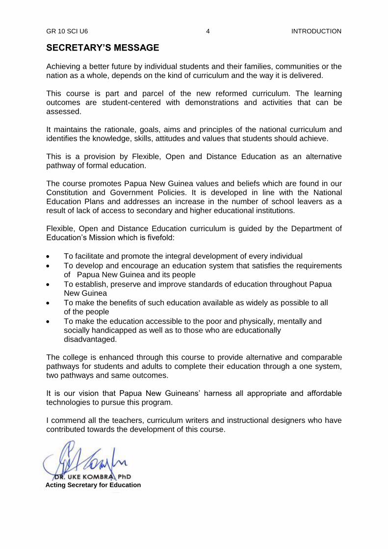
SECRETARY’S MESSAGE Achieving a better future by individual students and their families, communities or the nation as a whole, depends on the kind of curriculum and the way it is delivered. This course is part and parcel of the new reformed curriculum. The learning outcomes are student-centered with demonstrations and activities that can be assessed. It maintains the rationale, goals, aims and principles of the national curriculum and identifies the knowledge, skills, attitudes and values that students should achieve. This is a provision by Flexible, Open and Distance Education as an alternative pathway of formal education. The course promotes Papua New Guinea values and beliefs which are found in our Constitution and Government Policies. It is developed in line with the National Education Plans and addresses an increase in the number of school leavers as a result of lack of access to secondary and higher educational institutions. Flexible, Open and Distance Education curriculum is guided by the Department of Education‟s Mission which is fivefold:
To facilitate and promote the integral development of every individual
To develop and encourage an education system that satisfies the requirements of Papua New Guinea and its people
To establish, preserve and improve standards of education throughout Papua New Guinea
To make the benefits of such education available as widely as possible to all of the people
To make the education accessible to the poor and physically, mentally and socially handicapped as well as to those who are educationally
disadvantaged.
The college is enhanced through this course to provide alternative and comparable pathways for students and adults to complete their education through a one system, two pathways and same outcomes. It is our vision that Papua New Guineans‟ harness all appropriate and affordable technologies to pursue this program. I commend all the teachers, curriculum writers and instructional designers who have contributed towards the development of this course.
Acting Secretary for Education

GR 10 SCI U6 5 INTRODUCTION
UNIT INTRODUCTION
Dear Student,
Welcome to Unit 6 of your Grade 10 Science Course! I hope that you enjoyed studying the earlier Units. I also hope that this Unit on Geology will be an interesting and enjoyable subject to study too.
In this Unit, there are 20 Lessons on four Topics. The four topics are:
The Earth’s Crust
Rocks and their Classifications
Geological Activities
Geological Activities in Papua New Guinea There are three Lessons in the first Topic. The lessons will discuss on what is Geology and ways on how geologists make their discoveries. Your will learn from this topic the different parts of the Earth and their composition. You will also learn from this topic the evidences of heat within the earth‟s crust and the effects of volcanism. The second Topic is composed of eight Lessons and will discuss about the different types of rocks and their compositions. In this topic, the processes of weathering, soil erosion and deposition will be identified and described. In the third Topic, there are six Lessons that will discuss about the causes and effects of different geological activities such as formation of mountains, volcanoes and earthquakes. It will also talk about the importance of protecting living organisms and natural environment from harm caused by these activities. The last Topic has three Lessons. It will talk about the geological developments of Papua New Guinea. You will also learn from this Topic the location of PNG in the earthquake zone, and its effects. The types of volcanoes and volcanic eruptions are also described in this topic. Remember, you have to do all the activities and carry out the Practice Exercises after each lesson. Answers to Practice Exercises are at the end of each Topic. If you have any problems in understanding any of the lessons in this Unit, inform the Science Department at FODE Headquarters. This will help the teacher to revise the lessons for the next edition. You may study this Unit now following the Study Guide on the next page. All the Best!
GR 10 SCI U6 6 GUIDE
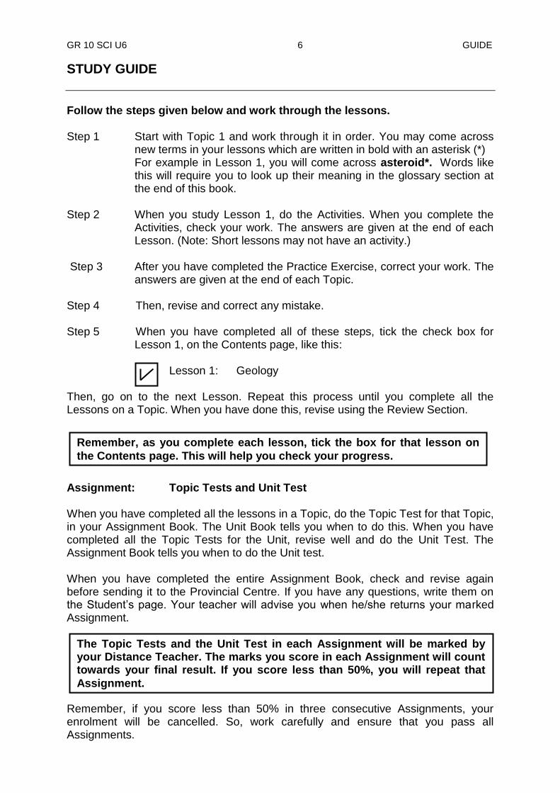
STUDY GUIDE
Follow the steps given below and work through the lessons. Step 1 Start with Topic 1 and work through it in order. You may come across
new terms in your lessons which are written in bold with an asterisk (*) For example in Lesson 1, you will come across asteroid*. Words like this will require you to look up their meaning in the glossary section at the end of this book.
Step 2 When you study Lesson 1, do the Activities. When you complete the
Activities, check your work. The answers are given at the end of each Lesson. (Note: Short lessons may not have an activity.)
Step 3 After you have completed the Practice Exercise, correct your work. The
answers are given at the end of each Topic. Step 4 Then, revise and correct any mistake. Step 5 When you have completed all of these steps, tick the check box for
Lesson 1, on the Contents page, like this: Lesson 1: Geology Then, go on to the next Lesson. Repeat this process until you complete all the Lessons on a Topic. When you have done this, revise using the Review Section. Assignment: Topic Tests and Unit Test When you have completed all the lessons in a Topic, do the Topic Test for that Topic, in your Assignment Book. The Unit Book tells you when to do this. When you have completed all the Topic Tests for the Unit, revise well and do the Unit Test. The Assignment Book tells you when to do the Unit test. When you have completed the entire Assignment Book, check and revise again before sending it to the Provincial Centre. If you have any questions, write them on the Student‟s page. Your teacher will advise you when he/she returns your marked Assignment. Remember, if you score less than 50% in three consecutive Assignments, your enrolment will be cancelled. So, work carefully and ensure that you pass all Assignments.
Remember, as you complete each lesson, tick the box for that lesson on
the Contents page. This will help you check your progress.
The Topic Tests and the Unit Test in each Assignment will be marked by your Distance Teacher. The marks you score in each Assignment will count towards your final result. If you score less than 50%, you will repeat that
Assignment.
GR 10 SCI U6 7 TITLE
TOPIC 1
THE EARTH’S CRUST
In this topic you will learn about
geology
structure of the earth
volcanism
GR 10 SCI U6 8 INTRODUCTION
INTRODUCTION TO TOPIC 1: THE EARTH’S CRUST
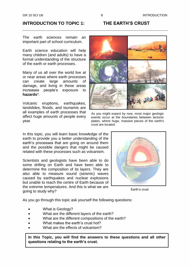
The earth sciences remain an important part of school curriculum. Earth science education will help many children (and adults) to have a formal understanding of the structure of the earth or earth processes. Many of us all over the world live at or near areas where earth processes can create large amounts of damage, and living in these areas increases people‟s exposure to hazards*. Volcanic eruptions, earthquakes, landslides, floods, and tsunamis are all examples of earth processes that affect huge amounts of people every year. In this topic, you will learn basic knowledge of the earth to provide you a better understanding of the earth‟s processes that are going on around them and the possible dangers that might be caused related with these processes such as volcanism. Scientists and geologists have been able to do some drilling on Earth and have been able to determine the composition of its layers. They are also able to measure sound (seismic) waves caused by earthquakes and nuclear explosions but unable to reach the centre of Earth because of the extreme temperatures. And this is what we are going to study why? As you go through this topic ask yourself the following questions:
What is Geology?
What are the different layers of the earth?
What are the different compositions of the earth?
What makes the earth‟s crust hot?
What are the effects of volcanism? In this Topic, you will find the answers to these questions and all other
questions relating to the earth’s crust.
As you might expect by now, most major geologic events occur at the boundaries between tectonic plates, where huge, massive pieces of the earth's crust are located.
Earth‟s crust
GR 10 SCI U6 9 TOPIC 1 LESSON 1
Lesson 1: Geology
Welcome to lesson 1 of this unit, Geology. In this lesson we are going to discuss about geology.
This planet Earth on which we live is more complicated than you think. There are scientists who are specialized in studying about the Earth. These scientists study about the rocks that form the external and internal parts of the Earth. They also study about the physical changes that are always happening in the Earth‟s surface.
What is Geology? The word geology was taken from the Greek words “geo”, which means “earth” and “logos” which means study. Therefore geology is the study of the structure and composition of the Earth. The scientists who study geology are called geologists. What does a geologist do? Geologists work to understand the history of our planet Earth. The better they can understand Earth‟s history, the better they can foresee how events and processes of the past might influence the future. Here are some examples what geologists study. 1. Earth processes
Many processes such as landslides, earthquakes, tsunamis, weather storms, floods and volcanic eruptions can be hazardous or unsafe to people. Geologists work to understand these processes well enough to warn the people of the occurrence of these events. They inform people to avoid building important structures where they might be damaged. They study the history of these events as recorded in rocks and try to determine when the next eruption or earthquake will occur.
Hazardous earth processes can lead to damage of properties and loss of many peoples‟ lives.
Your Aims:
define geology and geologists
explain how geologists make discoveries
identify tools used by geologists
The geologists study the Earth, the materials of which it is made, the structure of those materials, and the processes acting upon them. They also study the organisms that have lived on our planet. Most importantly, the geologists carry out research to find out how the earth’s materials, structures, processes and organisms have changed over time.
GR 10 SCI U6 10 TOPIC 1 LESSON 1
Geologists preparing to build petroleum drill core.
For example, if geologists can prepare maps of areas that have flooded in the past, they can prepare maps of areas that might be flooded in the future. These maps can be used to guide the development of communities and determine where flood protection or insurance is needed.
Geologists can warn people living near a volcano to vacate the area before its next eruption, or they can warn people of a tsunami that might occur in an area by studying the activities of the rocks in the solid crust under the sea.
3. Earth history Today we are concerned about climate change. Many geologists are working to learn about the past climates of earth and how they have changed across time. This historical, geological information is valuable to understand how our current climate is changing and what the results might be in the future. Geologists also examine events such as asteroid* impacts, mass extinctions, and ice ages. Geologic history shows that the processes that shaped the earth are still acting on it and that change is normal.
Building under water after a flood.
Sign board warning people of tsunami hazard zone.
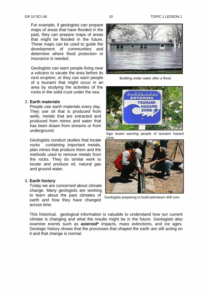
2. Earth materials People use earth materials every day. They use oil that is produced from wells, metals that are extracted and produced from mines and water that has been drawn from streams or from underground.
Geologists conduct studies that locate rocks containing important metals, plan mines that produce them and the methods used to remove metals from the rocks. They do similar work to locate and produce oil, natural gas and ground water.
GR 10 SCI U6 11 TOPIC 1 LESSON 1
Activity 1: Now test yourself by doing this activity. Answer the following questions on the spaces provided. 1. What is the Earth mainly made of?
______________________________________________________________
2. What is geology? ______________________________________________________________
3. What do we call the scientists who study geology? ______________________________________________________________ 4. List three things of the Earth that the geologists study. a) __________ b) __________ c) __________
Tools used by Geologists
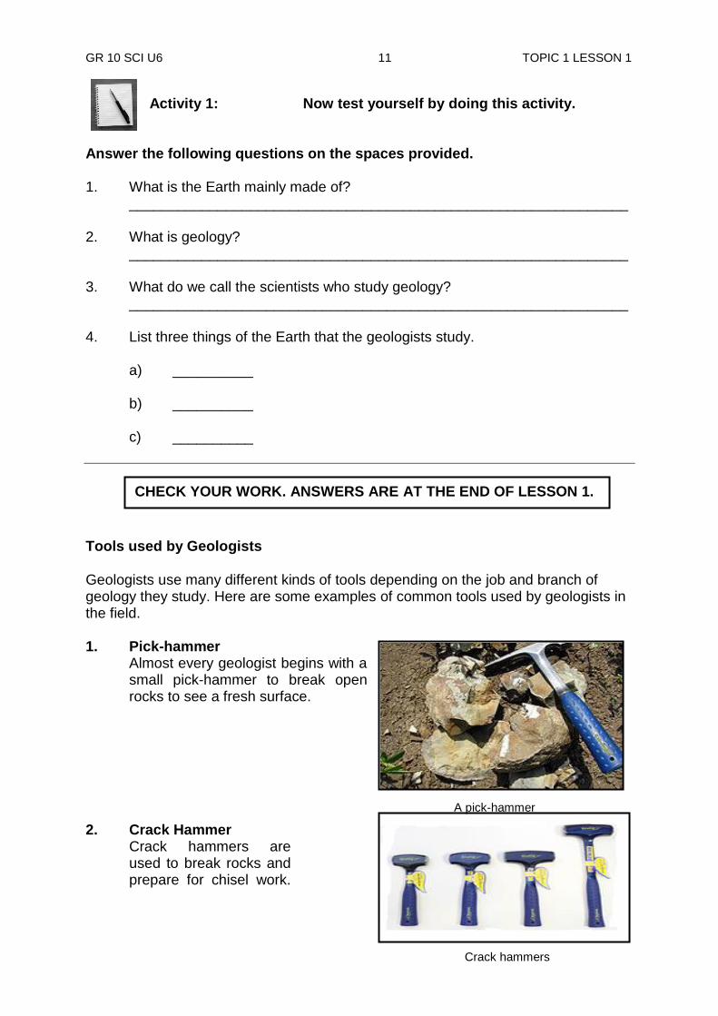
Geologists use many different kinds of tools depending on the job and branch of geology they study. Here are some examples of common tools used by geologists in the field. 1. Pick-hammer
Almost every geologist begins with a small pick-hammer to break open rocks to see a fresh surface.
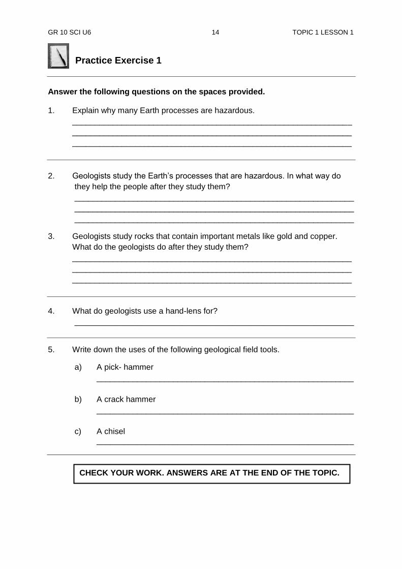
2. Crack Hammer Crack hammers are used to break rocks and prepare for chisel work.
A pick-hammer
Crack hammers
CHECK YOUR WORK. ANSWERS ARE AT THE END OF LESSON 1.

GR 10 SCI U6 12 TOPIC 1 LESSON 1
3. Rock Chisel Varieties of rock-chisels are used for prying, extracting mineral specimens, breaking rocks, and hunting fossils.
4. Hand-lens
A hand-lens is always carried by a geologist to inspect samples of rocks more closely in the field.
5. Compass
Compasses are used by geologists in mapping and surveying.
.
6. Hand-held computer Today hand-held computers are often used by geologists in field work to do digital geographic field mapping.
7. Satellite imagery A wide variety of cameras, instruments and sensors are installed in satellites* currently orbiting the earth. They capture images of land, sea and clouds, measure wave heights, sea temperature and elevations, wind speed and direction. Each piece of data contributes to developing an overall assessment of global weather and surf generation potential.
A geologist‟s compass
A hand- held mini computer
Hand-lenses
Rock chisels
Satellite orbiting the earth

GR 10 SCI U6 13 TOPIC 1 LESSON 1
Activity 2: Now test yourself by doing this activity.
Draw and label 1. With your pencil, draw and label the following geological tools.
a) Pick hammer
b) Crack hammer
c) Chisel
2. Describe the uses of a geologist‟s a) compass.
___________________________________________________________________________________________________________________________________________________________________________
b) field computer.
_____________________________________________________________________ _____________________________________________________________________
NOW DO PRACTICE EXERCISE 1 ON THE NEXT PAGE.
CHECK YOUR WORK. ANSWERS ARE AT THE END OF LESSON 1.
Summary
You have come to the end of lesson 1. In this lesson you have learnt that:
geology is the study of the Earth and (its structure and composition) what it is made of.
scientists who study the structure and composition of the Earth are called geologists.
natural processes that can lead to disaster and cause damage to people and the environment are called hazards.
geologists study natural processes and inform people to keep away from dangers ahead.
by studying rocks geologists are able to tell the minerals and petroleum deposits in a particular area under- ground.
geologists study the past and present climate of the Earth and they inform us of changes that are happening.
the common tools used by geologists for rock hunting are; crack hammer, chisel and pick-hammer.
mini computers and compasses are used by geologists in the field to do geographic mapping and surveying.
GR 10 SCI U6 14 TOPIC 1 LESSON 1
Practice Exercise 1
Answer the following questions on the spaces provided. 1. Explain why many Earth processes are hazardous.
______________________________________________________________
______________________________________________________________
______________________________________________________________
2. Geologists study the Earth‟s processes that are hazardous. In what way do
they help the people after they study them?
______________________________________________________________
______________________________________________________________
______________________________________________________________
3. Geologists study rocks that contain important metals like gold and copper.
What do the geologists do after they study them?
______________________________________________________________
______________________________________________________________
______________________________________________________________
4. What do geologists use a hand-lens for?
______________________________________________________________
5. Write down the uses of the following geological field tools.
a) A pick- hammer
_________________________________________________________
b) A crack hammer
_________________________________________________________
c) A chisel _________________________________________________________
CHECK YOUR WORK. ANSWERS ARE AT THE END OF THE TOPIC.
GR 10 SCI U6 15 TOPIC 1 LESSON 1
Answers to Activities Activity 1 1. Earth is mainly made of rocks.
2. Geology is the study of the structure and composition of the Earth. 3. The scientists who study geology are called geologists. 4. (a) history (b) processes (c) materials Activity 2
1.
2. a) A geologist‟s compass is used for mapping and surveying.
b) A hand-held computer is used for geographic mapping.
________________________________________________________________
a) Crack hammer b) pick- hammer c) chisel
GR 10 SCI U6 16 TOPIC 1 LESSON 2
Lesson 2: Structure of the Earth
Welcome to lesson 2. In lesson 1, we discussed about the study of geology and the work of geologists. We learned that geologists are scientists who study the Earth and what it is made of. They also study about the past history of the Earth and the changes that take place on the Earth‟s surface.
In this lesson we will look at what the inside of the Earth consists of. We will find out how geologists have come to realize what the inside of the earth looks like, the layers and what each of the layers are composed of.
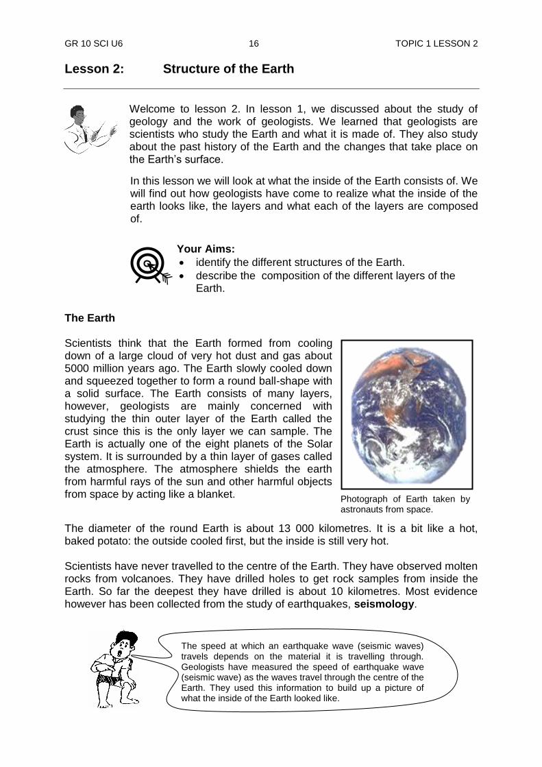
The Earth Scientists think that the Earth formed from cooling down of a large cloud of very hot dust and gas about 5000 million years ago. The Earth slowly cooled down and squeezed together to form a round ball-shape with a solid surface. The Earth consists of many layers, however, geologists are mainly concerned with studying the thin outer layer of the Earth called the crust since this is the only layer we can sample. The Earth is actually one of the eight planets of the Solar system. It is surrounded by a thin layer of gases called the atmosphere. The atmosphere shields the earth from harmful rays of the sun and other harmful objects from space by acting like a blanket.
The diameter of the round Earth is about 13 000 kilometres. It is a bit like a hot, baked potato: the outside cooled first, but the inside is still very hot. Scientists have never travelled to the centre of the Earth. They have observed molten rocks from volcanoes. They have drilled holes to get rock samples from inside the Earth. So far the deepest they have drilled is about 10 kilometres. Most evidence however has been collected from the study of earthquakes, seismology.
.
Your Aims:
identify the different structures of the Earth.
describe the composition of the different layers of the Earth.
The speed at which an earthquake wave (seismic waves) travels depends on the material it is travelling through. Geologists have measured the speed of earthquake wave (seismic wave) as the waves travel through the centre of the Earth. They used this information to build up a picture of what the inside of the Earth looked like.
Photograph of Earth taken by astronauts from space.
GR 10 SCI U6 17 TOPIC 1 LESSON 2
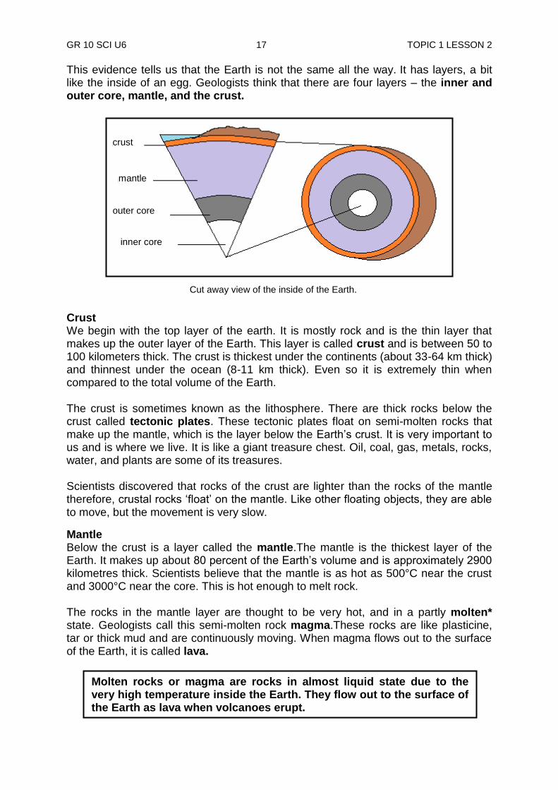
This evidence tells us that the Earth is not the same all the way. It has layers, a bit like the inside of an egg. Geologists think that there are four layers – the inner and outer core, mantle, and the crust.
Crust We begin with the top layer of the earth. It is mostly rock and is the thin layer that makes up the outer layer of the Earth. This layer is called crust and is between 50 to 100 kilometers thick. The crust is thickest under the continents (about 33-64 km thick) and thinnest under the ocean (8-11 km thick). Even so it is extremely thin when compared to the total volume of the Earth. The crust is sometimes known as the lithosphere. There are thick rocks below the crust called tectonic plates. These tectonic plates float on semi-molten rocks that make up the mantle, which is the layer below the Earth‟s crust. It is very important to us and is where we live. It is like a giant treasure chest. Oil, coal, gas, metals, rocks, water, and plants are some of its treasures. Scientists discovered that rocks of the crust are lighter than the rocks of the mantle therefore, crustal rocks „float‟ on the mantle. Like other floating objects, they are able to move, but the movement is very slow.
Mantle Below the crust is a layer called the mantle.The mantle is the thickest layer of the Earth. It makes up about 80 percent of the Earth‟s volume and is approximately 2900 kilometres thick. Scientists believe that the mantle is as hot as 500°C near the crust and 3000°C near the core. This is hot enough to melt rock. The rocks in the mantle layer are thought to be very hot, and in a partly molten* state. Geologists call this semi-molten rock magma.These rocks are like plasticine, tar or thick mud and are continuously moving. When magma flows out to the surface of the Earth, it is called lava.
Molten rocks or magma are rocks in almost liquid state due to the very high temperature inside the Earth. They flow out to the surface of the Earth as lava when volcanoes erupt.
crust
mantlet
outer core
inner core
Cut away view of the inside of the Earth.
crust
mantle
outer core
inner core
GR 10 SCI U6 18 TOPIC 1 LESSON 2
Outer core The outer core is 2300 kilometres thick and is made of mainly molten iron and nickel that gives the Earth its South and North poles and its magnetic field.
More recent studies by scientists have shown that very small amount of other elements such as silicon, sulphur and oxygen are also present.
The outer core is in a thick liquid state. The temperature at the outer core is about 3,000 degree Celsius (the temperature of the outer core ranges from 4000°C to 6000°C).
Scientists think that, as the Earth rotates, the thick liquid of the outer core spins. This produces a magnetic field around the Earth. This magnetic field protects us from dangerous cosmic rays from the Sun.
The inner core The inner core is the centre of the Earth and is 1300 kilometres thick. It is thought to be a heavy solid made of the same elements as the outer core. The temperature and pressure at the centre is so high that all the elements at the inner core behave like metals. The temperatures of the inner core range from 4000°C to 7000°C. At this temperature, more iron and nickel should be molten, but the massive weight of all the layers of rock above produces pressures so high that these metals are kept solid. Some silicon, oxygen and sulphur are also around.
SUMMARY OF THE STRUCTURE OF THE EARTH
Layers of the earth
Thickness (km)
Temperature (0C)
Description
Crust 8-64 20-500
Thickness varies (thickest under the continents and thinnest under oceans). Temperatures at the surface is 20
0C and 500
0C at the crust’s
maximum depth
Mantle 2900 500-2000 Partly solid, partly liquid, like a thick paste – very hot and always moving. Accounts for 80% of the Earth‟s volume
Outer core 2300 3000- 6000
Molten iron and nickel with traces of other elements. The Earth‟s magnetic field is generated by circulation movement of this liquid outer core
Inner core 1300 (radius) 4000-7000 Solid iron and nickel with small amount of other elements.
Cosmic rays are some kind of rays from outer space that have harmful effects on the living things on Earth.

GR 10 SCI U6 19 TOPIC 1 LESSON 2
Activity: Now test yourself by doing this activity.
A. Answer the following questions on the spaces provided.
1. How long ago was the Earth formed? ______________________________________________________________
2. Name the layers of the Earth from the surface to inside. ______________________________________________________________ 3. Which of the Earth‟s layers is the thickest?
______________________________________________________________ 4. Which of the layers is the thinnest? ______________________________________________________________ 5. Name the main elements that make up the core layers. ______________________________________________________________
B. Write true if the statement is true and false if the statement is false on the space before each statement.
1. __________ Earth was formed out of gas and dust.
2. __________ Geologists have drilled holes to the centre of the Earth.
3. __________ The inner core layer consists of liquid molten rocks.
4. __________ Rocks of the crust are always moving.
5. __________ The layer of crust is thick under the ocean than under the
continents.
CHECK YOUR WORK. ANSWERS ARE AT THE END OF LESSON 2.
GR 10 SCI U6 20 TOPIC 1 LESSON 2
NOW DO PRACTICE EXERCISE 2 ON THE NEXT PAGE.
Summary You have come to the end of lesson 2. In this lesson you have learnt that:
the age of the Earth had been estimated at about 5000 million years.
the four layers of the Earth are crust, mantle, inner core and outer core.
temperatures of the interior increases as you go further down into the Earth from the surface.
nickel and iron are the main components of the cores of the Earth‟s layers.
the Earth‟s rotation causes the outer core molten rocks to move. This produces magnetism around the Earth‟s surface.
the interior of the Earth is mostly molten.
information on the interior of the Earth is gathered from studies of earthquakes.

GR 10 SCI U6 21 TOPIC 1 LESSON 2
Practice Exercise 2
Answer the following questions on the spaces provided.
1. What evidence tells us that the Earth‟s interior is made up of molten rock? ______________________________________________________________ ______________________________________________________________
2. Explain why the rocks of the mantle are always moving.
____________________________________________________________________________________________________________________________
3. On the circle below, draw the 4 layers of the Earth. Label each layer and use different colours to shade in each part.
4. What is seismology? ______________________________________________________________
______________________________________________________________
5. What are cosmic rays? ______________________________________________________________
______________________________________________________________
6. What causes the magnetic field around the Earth? ______________________________________________________________
7. In what way does the Earth‟s magnetic field help us?
______________________________________________________________ ______________________________________________________________
CHECK YOUR WORK. ANSWERS ARE AT THE END OF TOPIC 1.

GR 10 SCI U6 22 TOPIC 1 LESSON 2
Answers to Activity
Part A.
1. About 5,000 million years ago. 2. Crust, mantle, outer core, inner core. 3. Mantle. 4. Crust. 5. Nickel and iron plus traces of other elements.
Part B.
1. True
2. False
3. False
4. False
5. False
CHECK YOUR WORK. ANSWERS ARE AT THE END OF TOPIC 1.
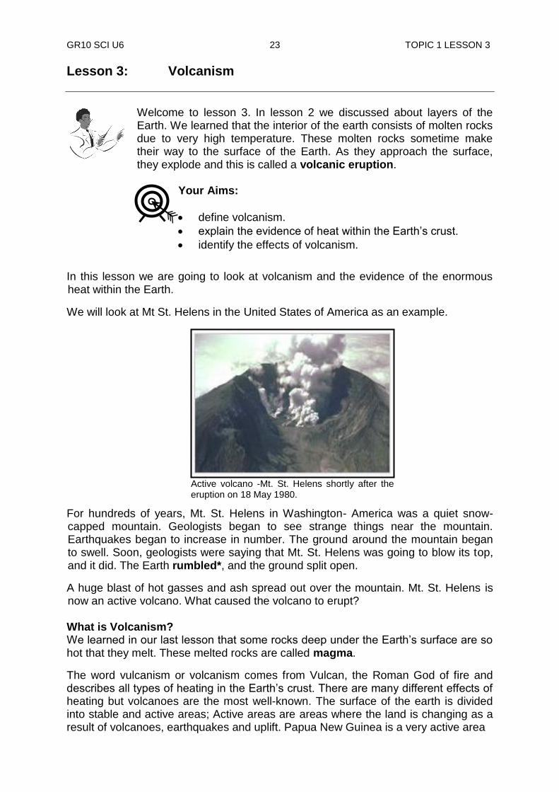
GR10 SCI U6 23 TOPIC 1 LESSON 3
Lesson 3: Volcanism
Welcome to lesson 3. In lesson 2 we discussed about layers of the Earth. We learned that the interior of the earth consists of molten rocks due to very high temperature. These molten rocks sometime make their way to the surface of the Earth. As they approach the surface, they explode and this is called a volcanic eruption.
In this lesson we are going to look at volcanism and the evidence of the enormous heat within the Earth.
We will look at Mt St. Helens in the United States of America as an example.
For hundreds of years, Mt. St. Helens in Washington- America was a quiet snow-capped mountain. Geologists began to see strange things near the mountain. Earthquakes began to increase in number. The ground around the mountain began to swell. Soon, geologists were saying that Mt. St. Helens was going to blow its top, and it did. The Earth rumbled*, and the ground split open.
A huge blast of hot gasses and ash spread out over the mountain. Mt. St. Helens is now an active volcano. What caused the volcano to erupt? What is Volcanism? We learned in our last lesson that some rocks deep under the Earth‟s surface are so hot that they melt. These melted rocks are called magma.
The word vulcanism or volcanism comes from Vulcan, the Roman God of fire and describes all types of heating in the Earth‟s crust. There are many different effects of heating but volcanoes are the most well-known. The surface of the earth is divided into stable and active areas; Active areas are areas where the land is changing as a result of volcanoes, earthquakes and uplift. Papua New Guinea is a very active area
Active volcano -Mt. St. Helens shortly after the eruption on 18 May 1980.
Your Aims:
define volcanism.
explain the evidence of heat within the Earth‟s crust.
identify the effects of volcanism.

GR10 SCI U6 24 TOPIC 1 LESSON 3
and this is shown by the number of volcanoes and earthquakes experienced. Stable areas are those areas with very little geological activities.
Magma forms in the Earth‟s mantle because of the enormous pressure and temperature of surrounding rocks. Sometimes this pressure forces the magma through a weaker part of the Earth‟s crust. The magma rises towards the surface because it is lighter than solid rock. It may push its way out through a crack or weak spot in the Earth‟s crust. If magma reaches the surface, it is called lava. When this happens a volcano is formed. A volcano is an opening in the Earth‟s surface or crust which allows hot magma and volcanic ash and gases to escape from below the surface.
How does a volcano form?
The diagram below shows how a volcano forms.
Stage 1. Magma forms in a pool deep in the Earth.
Stage 2. Cracks form in the rocks above the magma pools. The magma slowly moves up the cracks.
Stage 3. As the magma nears the surface, pressure builds up. The rocks begin to push with great force. Sometimes the magma slowly oozes out. At other times the volcano explodes. Material is thrown into the air. Magma also can reach the surface and flow out on the land. Geologists call this a lava flow.
Stage 4. A mountain formed in this way is called a volcanic mountain.
What comes out of volcanoes? To understand magma being squeezed out at the surface of the Earth, think of what happens when you shake a can of carbonated drink. Pressure builds up as long as you hold your thumb over the opening. When you lift up your thumb, you release the pressure, causing an eruption.
Volcanism is to do with the causes, and all the events connected with movement of magma from the mantle layer up the crust to form volcanic rocks on the surface of the Earth.
Crust
Magma pool
Mantle
1 2 3 4
Cracks
Lava flow
Dust, gas, ash Volcanic mountain
GR10 SCI U6 25 TOPIC 1 LESSON 3
Steam, rocks and hot gases mixed with lava, flows out of the crater. This hot material piles up, cools and hardens to form a volcanic mountain. When magma reaches the Earth‟s surface it is called lava. It is usually about 1,000 0C, and is red-hot. As it cools, the lava turns to solid rock, and rocks formed in this way are called igneous rocks. This may take weeks, or it may happen very quickly if the lava flows into water.
Some volcanoes erupt violently, throwing dust, ash, rock, steam and other gases high into the air. Lava is usually produced from time to time as well. A steep-sided volcanic cone is built up, with a crater at the top. Mt. St Helens is this type of volcano. Other volcanoes erupt quietly, with the lava spreading out to form a flat, shield-shaped volcano. Sometimes the lava is thin and runny. At other times it is thick and lumpy like water and flour mixture, and hardly flows at all.
Volcanoes also produce gases, and many of these are poisonous. When lava contains a lot of gases it may produce so much bubble. They look like soap bubbles in water. When this lava cools, the rock formed is full of holes where the gas bubbles used to be.
After a volcano has erupted and pressure has been released, the magma may harden to form a plug which blocks the vent. The eruption stops when this happens, and we say the volcano is dormant, or sleeping. If it doesn‟t erupt again, we say it is extinct, or dead. On the other hand, if pressure underneath the volcano builds up, it may become active or alive again.
Effects of volcanic eruption
1. Here are some substances released into the atmosphere during an eruption. Water vapour (H2O), carbon dioxide (CO2), sulphur dioxide (SO2), hydrogen chloride (HCl), hydrogen fluoride (HF) and ash. Some of them are poisonous, and they contribute to acid rain.
2. Ash thrown into the air by eruptions can be dangerous to the environment.
3. Volcanic eruptions also provide the benefit of adding nutrients to soil when rocks and ashes break down. These fertile soils assist the growth of plants and various crops.
4. Volcanic eruptions can also create new islands, as magma cools and solidifies upon contact with water.
Other effects of heat within the crust Water from the surface flow deep down into the Earth and come into contact with magma. The high temperature near the magma causes water to be heated enough that it boils. Sometime the water becomes so hot that it builds steam pressure and erupts in a jet above the surface of the Earth. This is called a geyser.
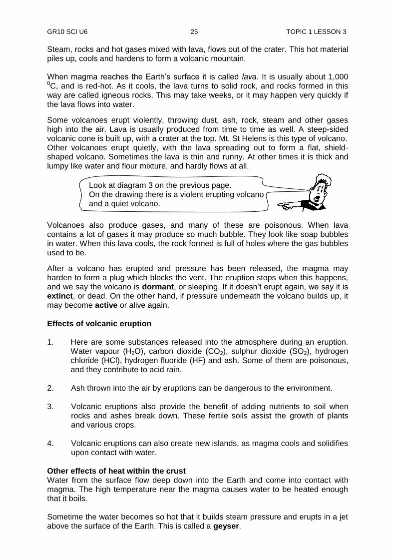
Look at diagram 3 on the previous page. On the drawing there is a violent erupting volcano and a quiet volcano.

GR10 SCI U6 26 TOPIC 1 LESSON 3
If the water only reaches the surface in the form of steam, it is called a hot spring.
If the water is mixed with mud and clay, it is called a mud pot.
Activity: Now test yourself by doing this activity.
A. Match each of the following with a word or words from the right-hand
column by drawing lines to match them.
i) Melted rock inside the Earth dormant
ii) Can awaken anytime lava iii) Melted rock on Earth‟s surface magma B. Copy and complete these sentences.
i) Molten rock under the Earth‟s surface is called __________.
ii) Molten rock that has reached the surface is called __________. iii) The „coming alive‟ of a volcano is called an __________. iv) Volcanoes are either active, __________ or __________.
A geyser
A mud pot
A hot spring in West New Britain PNG
GR10 SCI U6 27 TOPIC 1 LESSON 3
v) Magma is under a lot of __________. vi) When it cools lava turns to __________.
________________________________________________________________
NOW DO PRACTICE EXERCISE 3 ON THE NEXT PAGE.
Summary You have come to the end of lesson 3. In this lesson you have learnt that:
volcanic eruptions may be quiet lava flow, or violent explosions in which dust, ash, rock, steam and other gases are thrown out.
a molten material below the Earth‟s surface is called magma. Volcanoes are formed where the magma breaks through the surface along areas of weaknesses in the crust called fault lines.
when magma reaches the surface of the Earth it is called lava.
volcanoes may be active, dormant or extinct.
volcanism means all the events connected with volcanoes and volcanic activities.
gas emissions from volcanoes may be poisonous and can cause acid rain.
volcanic eruption improves soil fertility for plants‟ growth
geysers, hot springs and mud pots are a result of water inside the Earth being heated by hot magma.
volcano and earthquakes are found in active areas.
CHECK YOUR WORK. ANSWERS ARE AT THE END OF LESSON 3.
GR10 SCI U6 28 TOPIC 1 LESSON 3
Practice Exercise 3
Answer these questions on the spaces provided.
a) What is volcanism? ______________________________________________________________ ______________________________________________________________ b) What is a volcano? ______________________________________________________________ c) List at least 4 materials that come out of volcanoes.
i) _________________________________________________________
ii) _________________________________________________________
iii) _________________________________________________________
iv) _________________________________________________________
d) What is the difference in shape between a quiet volcano and an explosive one? ______________________________________________________________
______________________________________________________________
e) Describe one possible effect of poisonous gases released by erupting
volcanoes. ______________________________________________________________
______________________________________________________________
f) Describe the following types of volcanoes.
i) Dormant: _________________________________________________________ _________________________________________________________ ii) Extinct: _________________________________________________________
_________________________________________________________
iii) Active: _________________________________________________________
_________________________________________________________
g) What is the difference between a geyser and a hot spring? ______________________________________________________________
______________________________________________________________
______________________________________________________________ ______________________________________________________________
GR10 SCI U6 29 TOPIC 1 LESSON 3
h) What causes the water in the hot spring to heat up?
__________________________________________________________________________________________________________________________________________________________________________________________
Answers to activity
A.
(i) Melted rock inside the Ear th dormant ii) Can awaken anytime lava iii) Melted rock on Earth‟s surface magma B.
(i) magma (ii) lava (iii) eruption (iv) dormant or extinct (v) heat pressure (vi) rock
CHECK YOUR WORK. ANSWERS ARE AT THE END OF TOPIC 1.

GR 10 SCI U6 30 ANSWERS PRACTICE EXERCISES
Answers to Practice Exercises 1 - 3 Practice Exercise 1
1. They are called hazardous because they are unsafe and cause damage or
can be poisonous.
2. They warn the public to be ready for the next hazard so that the general public can be aware of the upcoming dangerous processes and avoid them.
3. They identify mine sites and inform people who can extract the important earth minerals in the rocks.
4. To inspect samples of rocks more closely in the fields 5. (a) pick-hammer: Used to break open a rock to see a fresh surface
(b) crack hammer: Used to break rocks and prepare chisel work
(c) chisel: Used for prying, extracting mineral specimens, breaking r ocks, and hunting fossils.
Practice Exercise 2 1. The hot lava from volcanic eruptions tell us that the Earth‟s interior is made up
of molten rock. 2. The rocks of the mantle are always moving due to very high pressure and
temperatures in the mantle. 3. 4. Seismology is the study of earthquakes. 5. Cosmic rays are some sort of rays from outer space that have harmful effects
on living things on Earth.
Crust
Mantle
Outer core Inner core
GR 10 SCI U6 31 ANSWERS PRACTICE EXERCISES
6 The Earth‟s magnetic field is caused by the circulation movement of liquid in outer core of the earth‟s structure.
7. This magnetic field protects us from dangerous cosmic rays from the Sun.
Practice Exercise 3 a) Volcanism is to do with every event connected to volcanoes and volcanic
activities.
b) A volcano is an opening on the Earth‟s surface that allows magma to escape from below the crust.
c) i) dust
ii) gas
iii) ash
iv) magma
v) rock
vi) steam
(Any four (4) answers are correct)
d) Explosive volcanoes are steep sided mountains while quiet ones are flat and shield shaped.
e) They produce acid rain.
f) (i) Volcanoes which are not active but at rest or sleeping. They may come alive some years later.
(ii) Volcanoes which have died out and are not luckily to come alive again.
(iii) Volcanoes which are currently alive or active.
g) Geysers erupt hot water in a jet while hot spring is a slow flow of hot water.
h) Hot magma from within the crust of the Earth.
REVISE TOPIC 1 USING THE MAIN POINTS ON THE NEXT PAGE.
GR 10 SCI U6 32 TITLE
REVIEW OF TOPIC 1: The Earth’s Crust
Now, revise all lessons in this Topic and then do ASSIGNMENT 6. Here are the main points to help you revise. Lesson 1: Geology
Geology is the study of the Earth and (its structure and composition) what it is made of.
Scientists who study geology are called geologists.
Natural processes that can lead to disaster and cause damage to people and the environment are called hazards.
Geologists study natural processes and inform people to keep away from dangers ahead.
By studying rocks geologists are able to tell the minerals and petroleum deposits in a particular area under- ground.
Geologists study the past and the present climate of the Earth and they inform us of the changes that are happening.
The common tools used by geologists for rock hunting are; crack hammer, chisel and pick-hammer.
Mini computers and compasses are used by geologists in the field to do geographic mapping and surveying.
Lesson 2: Structure of the Earth
The age of the Earth has been estimated at about 5000 million years.
The four layers of the Earth are crust, mantle, inner core and outer core.
Temperatures of the interior increases as you go further down into the Earth from the surface.
Nickel and iron are the main components of the cores of the Earth‟s layers.
The Earth‟s rotation causes the outer core molten rocks to move. This produces magnetism around the Earth‟s surface.
The interior of the Earth is mostly molten.
Information on the interior of the Earth is gathered from the studies of earthquakes.
Lesson 3: Vulcanism
Volcanic eruptions may be quiet lava flow, or violent explosions in which dust, ash, rock, steam and other gases are thrown out.
A molten material below the Earth‟s surface is called magma. Volcanoes are formed where the magma breaks through the surface along areas of weaknesses in the crust called fault lines.
When magma reaches the surface of the Earth, it is called lava.
Volcanoes may be active, dormant or extinct.
Volcanism means all the events connected with volcanoes and volcanic activities.
Gas emissions from volcanoes may be poisonous and cause acid rain.
Volcanic eruption improves soil fertility for plant growth.
Geysers, hot springs and mud pots are a result of water inside the Earth being heated by hot magma.
Volcano and earthquakes are found in active areas.
REVISE WELL AND THEN DO TOPIC TEST 1 IN YOUR ASSIGNMENT 6
GR 10 SCI U6 33 TITLE
TOPIC 2
ROCKS AND THEIR CLASSIFICATIONS
In this topic you will learn about
igneous rock
sedimentary rock
metamorphic rock
minerals and crystals
weathering
soil- a product of weathering
soil erosion
soil deposition
GR 10 SCI U6 34 INTRODUCTION
INTRODUCTION TO TOPIC 2: ROCKS AND THEIR CLASSIFICATIONS
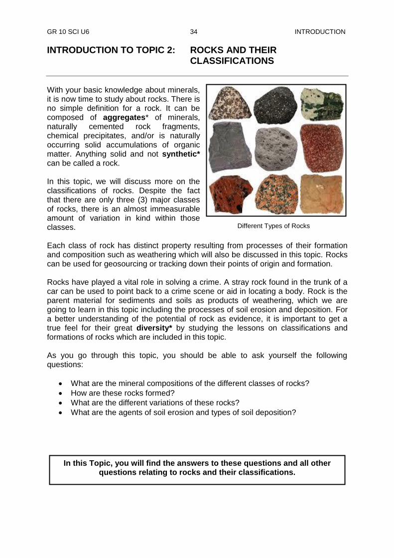
With your basic knowledge about minerals, it is now time to study about rocks. There is no simple definition for a rock. It can be composed of aggregates* of minerals, naturally cemented rock fragments, chemical precipitates, and/or is naturally occurring solid accumulations of organic matter. Anything solid and not synthetic* can be called a rock. In this topic, we will discuss more on the classifications of rocks. Despite the fact that there are only three (3) major classes of rocks, there is an almost immeasurable amount of variation in kind within those classes. Each class of rock has distinct property resulting from processes of their formation and composition such as weathering which will also be discussed in this topic. Rocks can be used for geosourcing or tracking down their points of origin and formation. Rocks have played a vital role in solving a crime. A stray rock found in the trunk of a car can be used to point back to a crime scene or aid in locating a body. Rock is the parent material for sediments and soils as products of weathering, which we are going to learn in this topic including the processes of soil erosion and deposition. For a better understanding of the potential of rock as evidence, it is important to get a true feel for their great diversity* by studying the lessons on classifications and formations of rocks which are included in this topic. As you go through this topic, you should be able to ask yourself the following questions:
What are the mineral compositions of the different classes of rocks?
How are these rocks formed?
What are the different variations of these rocks?
What are the agents of soil erosion and types of soil deposition?
In this Topic, you will find the answers to these questions and all other questions relating to rocks and their classifications.
Different Types of Rocks
GR 10 SCI U6 35 TOPIC 2 LESSON 4
Lesson 4: Igneous Rock
Welcome to Lesson 4. In previous lessons, and in the lower Grades, you learned about the three rock types. You were then introduced to the basic characteristics used to identify each rock type. You also learned that there is great heat and pressure under the crust which melt rocks. Some of these are forced out onto the surface through intrusions and volcanoes. You know from these lessons that the type of rocks formed from these activities is igneous rocks. You will continue to learn more about igneous rock.
Igneous Rock The word igneous means “from fire”. Igneous rocks are crystalline or glassy rocks formed by the cooling and solidification of molten magma. Therefore, igneous rocks are called fire rocks. You have learned that deep down towards the centre of the Earth, tremendous heat causes rocks to melt. The molten rocks or partially molten rock materials are called magma. Magma sometimes flows out onto the Earths‟ surface. When it reaches the surface, as in a volcano, it is known as lava. When magma cools, igneous rock is formed. Igneous rocks comprise one of the three principal classes of rocks, the others being metamorphic and sedimentary. The Earth is composed predominantly of a large mass of igneous rock with a very thin covering of sedimentary rock. Sedimentary rocks are produced by processes operating at the Earth‟s surface such as weathering and erosion, igneous and metamorphic rocks are form by internal processes that cannot be directly observed. You will learn more about sedimentary rocks in Lessons 5 and metamorphic rocks in Lesson 6. Mineral composition of rocks There are many ways of classifying rocks. One way is to classify rocks according to the type of mineral it has. Minerals are basically elements that make up a rock. You may be thinking that colour would be a good factor to tell the difference between the three types of rocks, however many elements could display similar colour. The mineral quartz can have a multitude of colours so that would not be good way to identify rock types. Therefore, it would be very difficult to identify using colour. The best way to distinguish between the three (3) different rocks would be its luster. Luster is the quality of light reflection. Under luster you would further divide into metallic and non-metallic luster. Moreover, you would continue to look at its
Your Aims:
define igneous rock
describe the minerals and composition of igneous rock
identify the types of igneous rock
describe how igneous rocks are formed
GR 10 SCI U6 36 TOPIC 2 LESSON 4
hardness, cleavage (how it breaks), its translucency (how much it allows light to penetrate it), colour, crystal form, texture, waxiness, taste and composition of the different elements. Formation of igneous rocks Igneous rocks are formed either underground or above ground. Underground, they are formed when the melted rock, called magma, deep within the earth becomes trapped in small pockets. As these pockets of magma cool slowly underground, the magma becomes igneous rocks. Igneous rocks are also formed when volcanoes erupt, causing magma to rise above the earth's surface. When magma appears above the earth, it is called lava as discussed earlier. Igneous rocks are formed as the lava cools above ground. Rocks formed from the cooling and solidification of magma deep within the crust are distinct from those formed through eruption at the surface due to the differences in conditions in the two environments. Within the Earth crust, the temperatures and pressures are much higher than at its surface. Consequently, the hot magma cools slowly and crystallises completely. The slow cooling promotes the growth of minerals large enough to be identified visually without the aid of a microscope. The rocks that are formed within the earth‟s surface are known as intrusive igneous rocks. On the other hand, magma erupted at the surface is chilled so quickly that the individual minerals have little or no chance to grow. These volcanic rocks, which are usually too fine-grained or glassy for their mineral composition to be observed without the use of a petrographic microscope, a type of microscope used to study rock, their mineral content and how they are formed. Consequently, they contain no minerals at all. These rocks that are formed outside or on the surface of the earth are known as extrusive igneous rocks. So igneous rocks formed by crystallisation from melting magma result in two groups of igneous rocks. They are igneous volcanic rock (extrusive rock) and igneous plutonic rock (intrusive rock).
Activity 1: Now test yourself by doing this activity.
Answer the following questions on the spaces provided.
1. Describe the following words.
a) magma _________________________________________________________
b) lava _________________________________________________________
Igneous rocks are classified according to where they cooled and solidified.
GR 10 SCI U6 37 TOPIC 2 LESSON 4
2. Where are igneous rocks formed? ______________________________________________________________
______________________________________________________________ 3. How are large crystals formed?
__________________________________________________________________________________________________________________________________________________________________________________________
4. What causes the magma within the Earth to cool and crystallise completely?
__________________________________________________________________________________________________________________________________________________________________________________________
Igneous Volcanic Rock (Extrusive Rock) Sometimes, molten magma flow out onto the surface as lava through a volcano. It is pushed out gradually, or it may be thrown out by large explosions. As soon as magma (lava) reaches the surface, it is exposed to low temperature. This temperature instantly cools the lava, hardening it into a rock. This hardened rock is known as igneous volcanic or extrusive rock. The instant cooling leaves no time for crystals* to form. This is why they have a fine-grain or aphanitic texture. (Aphanitic from the Greek aphanes, meaning "invisible"). Obsidian, pumice and basalt are examples of volcanic rocks having finer grains. Extrusive rocks occur in two forms. They form as lava flows that flood the land surface much like a river and as fragmented pieces of magma of various sizes (pyroclastic materials), which often are blown through the atmosphere and blanket the Earth's surface upon settling. Some examples of igneous volcanic rocks are shown below.
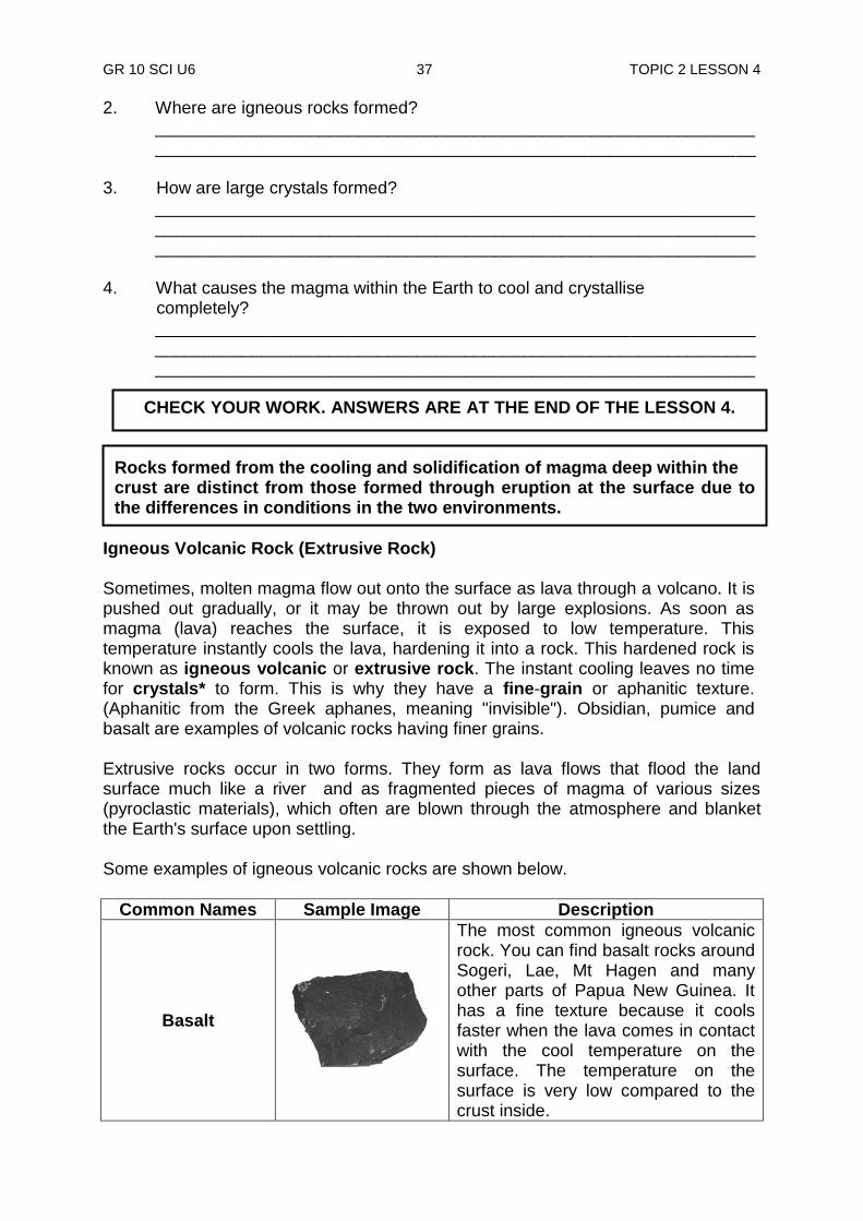
Common Names Sample Image Description
Basalt
The most common igneous volcanic rock. You can find basalt rocks around Sogeri, Lae, Mt Hagen and many other parts of Papua New Guinea. It has a fine texture because it cools faster when the lava comes in contact with the cool temperature on the surface. The temperature on the surface is very low compared to the crust inside.
CHECK YOUR WORK. ANSWERS ARE AT THE END OF THE LESSON 4.
Rocks formed from the cooling and solidification of magma deep within the crust are distinct from those formed through eruption at the surface due to the differences in conditions in the two environments.
GR 10 SCI U6 38 TOPIC 2 LESSON 4
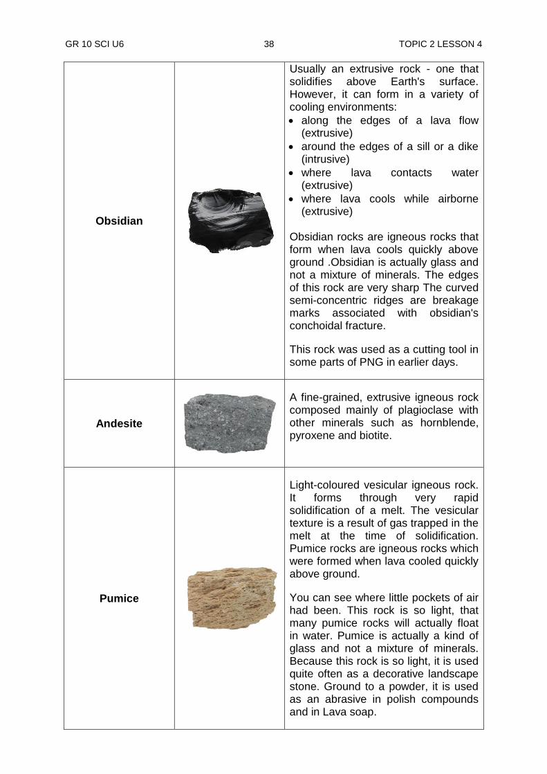
Obsidian
Usually an extrusive rock - one that solidifies above Earth's surface. However, it can form in a variety of cooling environments:
along the edges of a lava flow (extrusive)
around the edges of a sill or a dike (intrusive)
where lava contacts water (extrusive)
where lava cools while airborne (extrusive)
Obsidian rocks are igneous rocks that form when lava cools quickly above ground .Obsidian is actually glass and not a mixture of minerals. The edges of this rock are very sharp The curved semi-concentric ridges are breakage marks associated with obsidian's conchoidal fracture.
This rock was used as a cutting tool in some parts of PNG in earlier days.
Andesite
A fine-grained, extrusive igneous rock composed mainly of plagioclase with other minerals such as hornblende, pyroxene and biotite.
Pumice
Light-coloured vesicular igneous rock. It forms through very rapid solidification of a melt. The vesicular texture is a result of gas trapped in the melt at the time of solidification. Pumice rocks are igneous rocks which were formed when lava cooled quickly above ground.
You can see where little pockets of air had been. This rock is so light, that many pumice rocks will actually float in water. Pumice is actually a kind of glass and not a mixture of minerals. Because this rock is so light, it is used quite often as a decorative landscape stone. Ground to a powder, it is used as an abrasive in polish compounds and in Lava soap.
GR 10 SCI U6 39 TOPIC 2 LESSON 4
Scoria
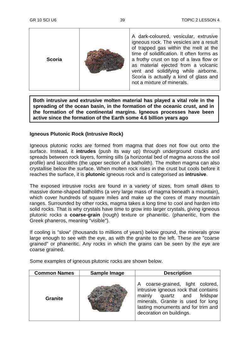
A dark-coloured, vesicular, extrusive igneous rock. The vesicles are a result of trapped gas within the melt at the time of solidification. It often forms as a frothy crust on top of a lava flow or as material ejected from a volcanic vent and solidifying while airborne. Scoria is actually a kind of glass and not a mixture of minerals.
Igneous Plutonic Rock (Intrusive Rock) Igneous plutonic rocks are formed from magma that does not flow out onto the surface. Instead, it intrudes (push its way up) through underground cracks and spreads between rock layers, forming sills (a horizontal bed of magma across the soil profile) and laccoliths (the upper section of a batholith). The molten magma can also crystallise below the surface. When molten rock rises in the crust but cools before it reaches the surface, it is plutonic igneous rock and is categorised as intrusive.
The exposed intrusive rocks are found in a variety of sizes, from small dikes to massive dome-shaped batholiths (a very large mass of magma beneath a mountain), which cover hundreds of square miles and make up the cores of many mountain ranges. Surrounded by other rocks, magma takes a long time to cool and harden into solid rocks. That is why crystals have time to grow into larger crystals, giving igneous plutonic rocks a coarse-grain (rough) texture or phaneritic. (phaneritic, from the Greek phaneros, meaning "visible").
If cooling is "slow" (thousands to millions of years) below ground, the minerals grow large enough to see with the eye, as with the granite to the left. These are "coarse grained" or phaneritic. Any rocks in which the grains can be seen by the eye are coarse grained.
Some examples of igneous plutonic rocks are shown below.
Common Names Sample Image Description
Granite
A coarse-grained, light colored, intrusive igneous rock that contains mainly quartz and feldspar minerals. Granite is used for long lasting monuments and for trim and decoration on buildings.
Both intrusive and extrusive molten material has played a vital role in the spreading of the ocean basin, in the formation of the oceanic crust, and in the formation of the continental margins. Igneous processes have been active since the formation of the Earth some 4.6 billion years ago
GR 10 SCI U6 40 TOPIC 2 LESSON 4
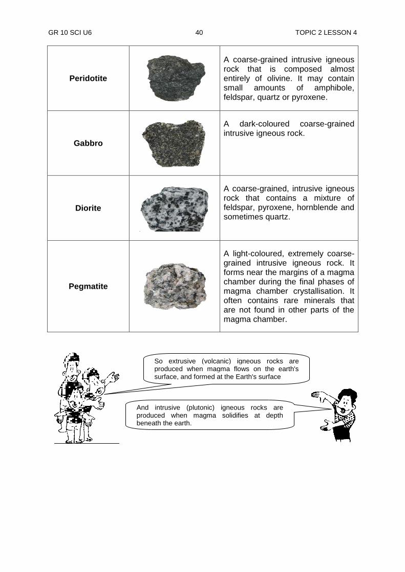
Peridotite
A coarse-grained intrusive igneous rock that is composed almost entirely of olivine. It may contain small amounts of amphibole, feldspar, quartz or pyroxene.
Gabbro
A dark-coloured coarse-grained intrusive igneous rock.
Diorite
A coarse-grained, intrusive igneous rock that contains a mixture of feldspar, pyroxene, hornblende and sometimes quartz.
Pegmatite
A light-coloured, extremely coarse-grained intrusive igneous rock. It forms near the margins of a magma chamber during the final phases of magma chamber crystallisation. It often contains rare minerals that are not found in other parts of the magma chamber.
So extrusive (volcanic) igneous rocks are produced when magma flows on the earth's surface, and formed at the Earth's surface
And intrusive (plutonic) igneous rocks are produced when magma solidifies at depth beneath the earth.
GR 10 SCI U6 41 TOPIC 2 LESSON 4
Activity 2: Now test yourself by doing this activity.
Answer the following questions on the spaces provided. 1. List down examples of phaneritic or coarse-grained igneous rocks. ____________________________________________________________ ____________________________________________________________ 2. Briefly describe how intrusive igneous rocks are formed ____________________________________________________________ ____________________________________________________________ 3. Explain how extrusive igneous rocks are formed ____________________________________________________________ ____________________________________________________________
Mineral Composition of Igneous Rocks As you have learned earlier, mineral composition of a rock is important in helping geologists, identify and classify different rock types. Magma that forms igneous rocks comes from different areas of the crust. Therefore, it contains different minerals with different chemical compounds. The colour of a rock gives a clue of the mineral content of a rock. Igneous rocks vary in colour, from almost light to dark. Light-coloured igneous rocks such as granite and pumice are rich in quartz, feldspar and other light-coloured minerals.
CHECK YOUR WORK. ANSWERS ARE AT THE END OF LESSON 4.
Quartz Felspar

GR 10 SCI U6 42 TOPIC 2 LESSON 4
Biotite Mica Mica Olivine Amphibole
Dark-coloured igneous rocks are rich in biotite mica, olivine and other dark-coloured minerals. They also contain dark minerals and are usually heavy.
Classification of Igneous Rocks Igneous rocks are classified in several different ways, but all rock classifications are a combination of texture and color/composition of the rock. Igneous rocks are classified on the basis of mineralogy, chemistry, and texture. As discussed earlier, texture is used to subdivide igneous rocks into two major groups: (1) plutonic rocks, with mineral grain sizes that are visible to the naked eye, and (2) volcanic rocks, which are usually too fine-grained or glassy for their mineral composition to be observed without the use of a petrographic microscope The colour/composition of the rock is at its simplest divided into dark coloured rocks (mafic), intermediate coloured rocks (intermediate), and light coloured rocks (felsic). If we combine texture/cooling history and colour/composition in a grid we get the classification in the table below. This can be used as an aid only.
Texture
Felsic (Light Color)
Intermediate Mafic
( Dark Color) Ultramafic
Coarse Granite Diorite Gabbro Periodotite
Fine Rhyolite Andesite Basalt
Vesicular Pumice Scoria
Glassy Obsidian
Minerals Present
Quartz K feldspar
Na-Ca Plag Amphibole
Ca Plag Pyroxene
Pyroxene Olivine
SIMPLE CLASSIFICATION OF IGNEOUS ROCKS
GR 10 SCI U6 43 TOPIC 2 LESSON 4
Coarse grained Individual mineral grains can be seen with the naked eye. Rock must have cooled slowly to allow large crystals to develop. Fine grained Mineral grains are present but are two small to be seen with the eye. Cooled rapidly, before crystals had a chance to grow. Vesicular Rock containing vesicles (gas holes). Always light weight. An example is pumice. Glassy Not composed of minerals at all but a true glass. Glasses are not crystalline. There are two ideas about igneous rocks that are geologically important. The first idea is that igneous rocks evolve - they change from one kind of rock into another. The second idea is that rocks are not randomly distributed across the earth. Specific kinds of rocks are always found in specific places for specific reasons, all tied into plate tectonic processes. If classification and identification was all there was to igneous rocks, there would not be much use studying them. We classify rocks to learn what they can tell us about the earth.
NOW DO PRACTICE EXERCISE 4 ON THE NEXT PAGE
Remember: All typical classification schemes rely on a combination of texture, particularly grain size, and mineralogy. But, keep in mind they are
process-oriented. Coarse grained are plutonic, fine grained are volcanic.
Summary You have come to the end of lesson 4. In this lesson you have learnt that:
the word igneous means “from fire”. Igneous rocks are crystalline or glassy rocks formed by the cooling and solidification of molten magma.
intrusive rocks are formed from slow cooling of magma; this allows crystals to form throughout the rock. Extrusive rocks form quickly usually above the surface so there is no time for visible crystals to form.
igneous rocks can be either extrusive or intrusive based on how fast or slow the magma cools.
igneous rocks are crystalline or glassy rocks formed by the cooling and solidification of molten magma.
GR 10 SCI U6 44 TOPIC 2 LESSON 4
Practice Exercise 4
Answer the following questions on the spaces provided. 1. Why is mineral composition important to a geologist? _____________________________________________________________________
______________________________________________________________ ______________________________________________________________
2. What does the colour of a rock show? ______________________________________________________________ ______________________________________________________________ ______________________________________________________________
3. How is igneous plutonic rock formed? ______________________________________________________________
______________________________________________________________ ______________________________________________________________
4. How is igneous volcanic rock formed? ______________________________________________________________ 5. List 2 names of igneous plutonic rocks. i) ____________________________ ii) ______________________________ 6. a) What is the name of the igneous volcanic rock that is very light in weight? ______________________________________________________________ b) List two of its uses.
i)_____________________________________________________________ ii) ______________________________________________________________
7. List the names of two other igneous volcanic rocks. i) _____________________________ ii) _____________________________
CHECK YOUR WORK. ANSWERS ARE AT THE END OF TOPIC 2.
GR 10 SCI U6 45 TOPIC 2 LESSON 4
Answers to Activities Activity 1 1. a) magma is molten rock of partially molten rock.
b) When magma reaches the surface of the earth is known as lava 2. Igneous rocks are formed either underground or above ground. They are
formed by cooling and solidification of molten magma. 3. Large crystals are formed when hot magma cools slowly and crystallises
completely. 4. The high pressure and high temperature within the earth. Activity 2 1. Granite, Pegmatite, Gabbro, Diorite, Peridotite 2. Intrusive (plutonic) igneous rocks are produced when magma solidifies at depth beneath the earth. 3. Extrusive (volcanic) igneous rocks are produced when magma flows on the earth's surface, and solidifies at the Earth's surface.
GR 10 SCI U6 46 TOPIC 2 LESSON 5
Lesson 5: Sedimentary Rocks
Welcome to lesson 5. In this lesson you will learn about the second type of rock known as sedimentary rocks. The land around you, no matter where you live, is made of rocks. If you live in a place that has good rich soil, the soil itself is finely broken down or becomes weathered rocks. People who live in desert regions can easily find rocks on the surface. These rocks lay on a surface of clay that is also a product of weathering. Weathering is the process of breaking down rocks and minerals into smaller pieces by water, wind, and ice. You will learn more about weathering in Lesson 8 of this topic.
Sedimentary Rock The word sedimentary comes from the Latin word sedimentum, which means settling. Sedimentary rocks make up only about 5% of the Earth's lithosphere, but they are concentrated near the surface and actually represent about 75% of those rocks exposed at the surface. The physical characteristics (grains, crystals and cements) and fossils of sediments and sedimentary rocks provide an important record of Earth‟s history. The physical make up of these rocks provides many clues as to where and how the rocks may have formed. Fossils, which represent traces or remains of prehistoric life preserved in sedimentary rocks, allow us to study the history of life on Earth.
.
Formation of sedimentary rocks Sedimentary rocks are formed from the breaking apart of other rocks (igneous, metamorphic, or sedimentary rocks) and the cementation, compaction and recrystallization of these broken pieces of rock or pieces of once-living organisms
Sedimentary rocks also have important commercial value as a source of petroleum, ground water, building materials, and economically valuable mineral deposits such as aluminum, gold, iron and others.
Your Aims:
define sedimentary rock
describe how sedimentary rock are formed
describe the mineral composition of sedimentary rocks
identify the types of sedimentary rock
GR 10 SCI U6 47 TOPIC 2 LESSON 5
Weathering at the Earth's surface provides the basic material for the formation of sedimentary rocks.
These broken pieces of rock are called sediments. The word "sedimentary" comes from the root word "Sediment". The igneous rocks along with any other form of rock materials are weathered-down every now and then into sediments by the sun, rain, wind, ice and many other agents, (refer to Lesson 8). It takes thousands of years for rocks to form into sediments. Weathered-down sediments are carried down from mountains and valleys and deposited at lower plain areas by erosion, running water, wind, landslide and melting ice. You will study more of these later in Lessons 8 and 9.
Transformation process The deposited sediments build up in layers on top of each other as more and more fresh sediments are brought down and laid over them. As the depth of the buried sediments increase, they are subjected to higher temperature and pressure. These high temperature and pressure help transform sediments into sedimentary rocks.
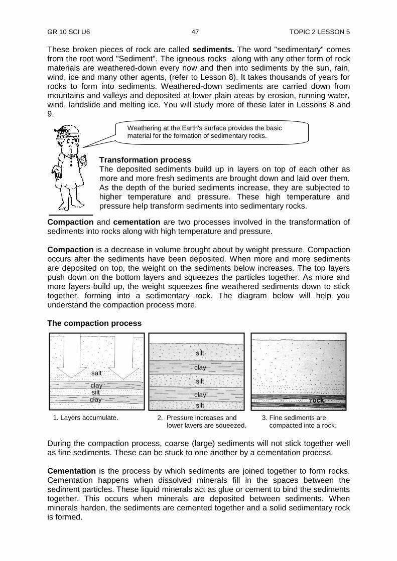
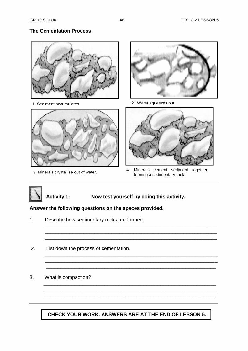
Compaction and cementation are two processes involved in the transformation of sediments into rocks along with high temperature and pressure. Compaction is a decrease in volume brought about by weight pressure. Compaction occurs after the sediments have been deposited. When more and more sediments are deposited on top, the weight on the sediments below increases. The top layers push down on the bottom layers and squeezes the particles together. As more and more layers build up, the weight squeezes fine weathered sediments down to stick together, forming into a sedimentary rock. The diagram below will help you understand the compaction process more. The compaction process
During the compaction process, coarse (large) sediments will not stick together well as fine sediments. These can be stuck to one another by a cementation process. Cementation is the process by which sediments are joined together to form rocks. Cementation happens when dissolved minerals fill in the spaces between the sediment particles. These liquid minerals act as glue or cement to bind the sediments together. This occurs when minerals are deposited between sediments. When minerals harden, the sediments are cemented together and a solid sedimentary rock is formed.
1. Layers accumulate
2. Pressure increases and lower layers are squeezed.
3. Fine sediments are compacted into a rock.
1. Layers accumulate.
salt
clay silt clay
silt
clay
silt
clay
silt rock
GR 10 SCI U6 48 TOPIC 2 LESSON 5
The Cementation Process
Activity 1: Now test yourself by doing this activity.
Answer the following questions on the spaces provided. 1. Describe how sedimentary rocks are formed. ______________________________________________________________ ______________________________________________________________ ______________________________________________________________ 2. List down the process of cementation. ______________________________________________________________ ______________________________________________________________ _____________________________________________________________ 3. What is compaction? ______________________________________________________________ ______________________________________________________________ _____________________________________________________________
3. Minerals crystallise out of water.
1. Sediment accumulates. 2. Water squeezes out.
4. Minerals cement sediment together forming a sedimentary rock.
rock
CHECK YOUR WORK. ANSWERS ARE AT THE END OF LESSON 5.
GR 10 SCI U6 49 TOPIC 2 LESSON 5
Types of sedimentary rock There are three basic types of sedimentary rocks. Each of them are formed from a different kind of sediment. 1) clastic sedimentary rocks such as breccia, conglomerate, sandstone and shale,
are formed from mechanical or physical weathering debris;
Clastic sedimentary rock is formed by cementing and compacting together broken pieces of rocks and minerals. These are the group of rocks most people think of when they think of sedimentary rocks. We have discussed about cementing and compacting of rocks earlier in the lesson. Clastic sedimentary rocks may have particles ranging in size from microscopic clay to huge boulders. Their names are based on their clast or grain size. The smallest grains are called clay, then silt, then sand. Grains larger than two millimetres are called pebbles. Shale is a rock made mostly of clay, siltstone is made up of silt-sized grains, sandstone is made of sand-sized clasts, and conglomerate is made of pebbles surrounded by a matrix of sand or mud.
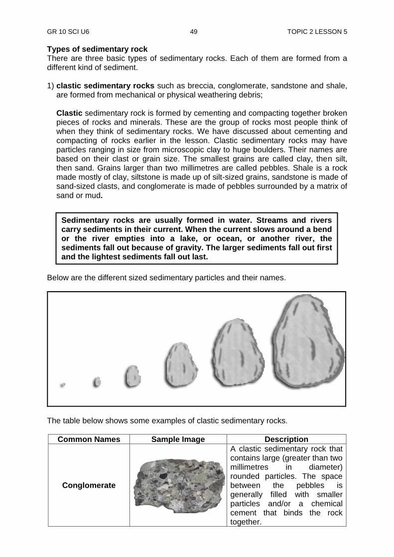
Below are the different sized sedimentary particles and their names.
The table below shows some examples of clastic sedimentary rocks.
Common Names Sample Image Description
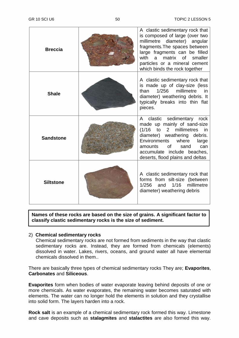
Conglomerate
A clastic sedimentary rock that contains large (greater than two millimetres in diameter) rounded particles. The space between the pebbles is generally filled with smaller particles and/or a chemical cement that binds the rock together.
Sedimentary rocks are usually formed in water. Streams and rivers carry sediments in their current. When the current slows around a bend or the river empties into a lake, or ocean, or another river, the sediments fall out because of gravity. The larger sediments fall out first and the lightest sediments fall out last.
GR 10 SCI U6 50 TOPIC 2 LESSON 5
Breccia
A clastic sedimentary rock that is composed of large (over two millimetre diameter) angular fragments.The spaces between large fragments can be filled with a matrix of smaller particles or a mineral cement which binds the rock together
Shale
A clastic sedimentary rock that is made up of clay-size (less than 1/256 millimetre in diameter) weathering debris. It typically breaks into thin flat pieces.
Sandstone
A clastic sedimentary rock made up mainly of sand-size (1/16 to 2 millimetres in diameter) weathering debris. Environments where large amounts of sand can accumulate include beaches, deserts, flood plains and deltas
Siltstone
A clastic sedimentary rock that forms from silt-size (between 1/256 and 1/16 millimetre diameter) weathering debris
2) Chemical sedimentary rocks
Chemical sedimentary rocks are not formed from sediments in the way that clastic sedimentary rocks are. Instead, they are formed from chemicals (elements) dissolved in water. Lakes, rivers, oceans, and ground water all have elemental chemicals dissolved in them..
There are basically three types of chemical sedimentary rocks They are; Evaporites, Carbonates and Siliceous. Evaporites form when bodies of water evaporate leaving behind deposits of one or more chemicals. As water evaporates, the remaining water becomes saturated with elements. The water can no longer hold the elements in solution and they crystallise into solid form. The layers harden into a rock. Rock salt is an example of a chemical sedimentary rock formed this way. Limestone and cave deposits such as stalagmites and stalactites are also formed this way.
Names of these rocks are based on the size of grains. A significant factor to classify clastic sedimentary rocks is the size of sediment.
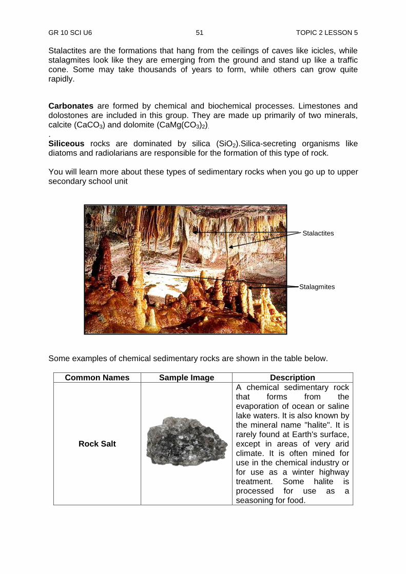
GR 10 SCI U6 51 TOPIC 2 LESSON 5
Stalactites are the formations that hang from the ceilings of caves like icicles, while stalagmites look like they are emerging from the ground and stand up like a traffic cone. Some may take thousands of years to form, while others can grow quite rapidly.
Carbonates are formed by chemical and biochemical processes. Limestones and dolostones are included in this group. They are made up primarily of two minerals, calcite (CaCO3) and dolomite (CaMg(CO3)2). . Siliceous rocks are dominated by silica (SiO2).Silica-secreting organisms like diatoms and radiolarians are responsible for the formation of this type of rock. You will learn more about these types of sedimentary rocks when you go up to upper secondary school unit
Some examples of chemical sedimentary rocks are shown in the table below.
Common Names Sample Image Description
Rock Salt
A chemical sedimentary rock that forms from the evaporation of ocean or saline lake waters. It is also known by the mineral name "halite". It is rarely found at Earth's surface, except in areas of very arid climate. It is often mined for use in the chemical industry or for use as a winter highway treatment. Some halite is processed for use as a seasoning for food.
Stalactites
Stalagmites

GR 10 SCI U6 52 TOPIC 2 LESSON 5
Iron Ore
A chemical sedimentary rock that forms when iron and oxygen (and sometimes other substances) combine in solution and deposit as a sediment. Hematite (shown above) is the most common sedimentary iron ore mineral.
Tufa
A porous limestone that forms from the precipitation of calcium carbonate, often at a hot spring or along the shoreline of a lake where waters are saturated with calcium carbonate.
Chert
A microcrystalline or cryptocrystalline sedimentary rock material composed of silicon dioxide (SiO2). It occurs as nodules and concretionary masses and less frequently as a layered deposit. It breaks with a conchoidal fracture, often producing very sharp edges. Early people took advantage of how chert breaks and used it to fashion cutting tools and weapons.
Chalk
A fine-grained, light-colored limestone formed from the calcium carbonate skeletal remains of tiny marine organisms.
Fossiliferous Limestone
A limestone that contains the remains of ancient plants or animals in the form of fossils.
3) Organic sedimentary rock is formed from substances that were once living (plant
and animal). An example of this is fossils. When animals with shells die, their shells sink into the ocean floor. As layers of shells build up, they harden into a rock. Organic sedimentary rocks such as coal and some limestones form from the accumulation of plant or animal debris.
Coal is another organic rock. It has been formed from dead plants buried in
ancient swamps. The illustrations below show the formation of coal.

GR 10 SCI U6 53 TOPIC 2 LESSON 5
Coal is used as fuel (firewood). Large amounts of these have been found in USA. They could last over a hundred years. Today coal is used mainly as fuel in electric power generating plants.
Common Names Sample Image Description
Peat
A mass of recently accumulated to partially carbonised plant debris. This material is on its way to becoming coal but its plant debris source is still easily recognisable.
Lignite
The lowest rank of coal is "lignite". It is peat that has been compressed, dewatered and lithified into a rock. It often contains recognisable plant structures.
1. A swamp Forest. 2. Plants die and sink to the bottom of a swamp.
3. Thick layer of partly decayed plants build up.
peat
4. Swamp dries up and layers of sediments (peat) form lignite.
lignite
6. Intense heat and pressure forms anthracite coal.
Anthracite coal metamorphic rock
5. Further pressure forms bituminous coal.
Bituminous coal (sedimentary rock)
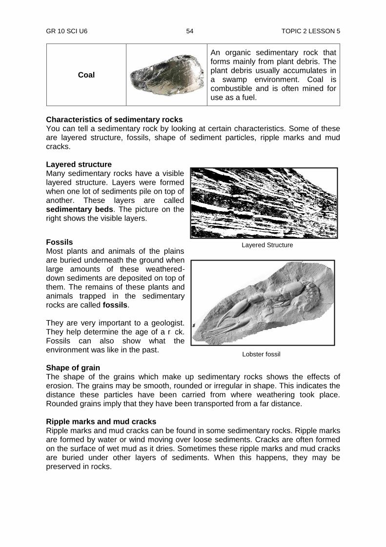
GR 10 SCI U6 54 TOPIC 2 LESSON 5
Layered Structure
Coal
An organic sedimentary rock that forms mainly from plant debris. The plant debris usually accumulates in a swamp environment. Coal is combustible and is often mined for use as a fuel.
Characteristics of sedimentary rocks You can tell a sedimentary rock by looking at certain characteristics. Some of these are layered structure, fossils, shape of sediment particles, ripple marks and mud cracks. Layered structure Many sedimentary rocks have a visible layered structure. Layers were formed when one lot of sediments pile on top of another. These layers are called sedimentary beds. The picture on the right shows the visible layers.
Fossils Most plants and animals of the plains are buried underneath the ground when large amounts of these weathered-down sediments are deposited on top of them. The remains of these plants and animals trapped in the sedimentary rocks are called fossils. They are very important to a geologist. They help determine the age of a rock. Fossils can also show what the environment was like in the past. Shape of grain The shape of the grains which make up sedimentary rocks shows the effects of erosion. The grains may be smooth, rounded or irregular in shape. This indicates the distance these particles have been carried from where weathering took place. Rounded grains imply that they have been transported from a far distance. Ripple marks and mud cracks Ripple marks and mud cracks can be found in some sedimentary rocks. Ripple marks are formed by water or wind moving over loose sediments. Cracks are often formed on the surface of wet mud as it dries. Sometimes these ripple marks and mud cracks are buried under other layers of sediments. When this happens, they may be preserved in rocks.
Lobster fossil

GR 10 SCI U6 55 TOPIC 2 LESSON 5
NOW DO PRACTICE EXERCISE 5 ON THE NEXT PAGE.
Summary You have come to the end of lesson 5. In this lesson you have learnt that:
compaction and cementation are two processes involved in the transformation of sediments into rocks along with high temperature and pressure.
clastic sedimentary rocks such as breccia, conglomerate, sandstone and shale, are formed from mechanical or physical weathering debris; Chemical sedimentary rock is formed from minerals that were once dissolved in water.
you can tell a sedimentary rock by looking at certain characteristics which are layered structure, fossils, shape of sediment particles, ripple marks and mud cracks.
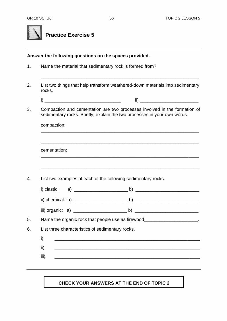
GR 10 SCI U6 56 TOPIC 2 LESSON 5
Practice Exercise 5
Answer the following questions on the spaces provided. 1. Name the material that sedimentary rock is formed from?
______________________________________________________________
2. List two things that help transform weathered-down materials into sedimentary rocks.
i) ______________________________ ii) _______________________
3. Compaction and cementation are two processes involved in the formation of sedimentary rocks. Briefly, explain the two processes in your own words.
compaction:
______________________________________________________________ ______________________________________________________________
cementation: ______________________________________________________________ ______________________________________________________________
4. List two examples of each of the following sedimentary rocks.
i) clastic: a) _____________________ b) _________________________ ii) chemical: a) _____________________ b) _________________________ iii) organic: a) _____________________ b) _________________________
5. Name the organic rock that people use as firewood_____________________.
6. List three characteristics of sedimentary rocks.
i) _________________________________________________________
ii) _________________________________________________________
iii) _________________________________________________________
CHECK YOUR ANSWERS AT THE END OF TOPIC 2
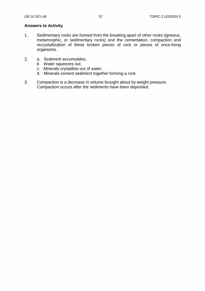
GR 10 SCI U6 57 TOPIC 2 LESSON 5
Answers to Activity 1. Sedimentary rocks are formed from the breaking apart of other rocks (igneous,
metamorphic, or sedimentary rocks) and the cementation, compaction and recrystallization of these broken pieces of rock or pieces of once-living organisms.
2. a. Sediment accumulates.
b Water squeezes out. c. Minerals crystallise out of water. d. Minerals cement sediment together forming a rock.
3. Compaction is a decrease in volume brought about by weight pressure. Compaction occurs after the sediments have been deposited.
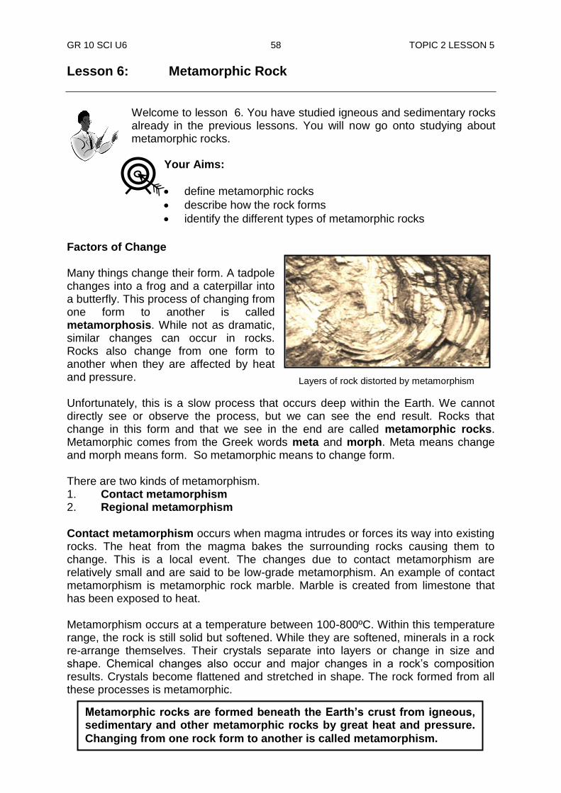
GR 10 SCI U6 58 TOPIC 2 LESSON 5
Lesson 6: Metamorphic Rock
Welcome to lesson 6. You have studied igneous and sedimentary rocks already in the previous lessons. You will now go onto studying about metamorphic rocks.
Factors of Change Many things change their form. A tadpole changes into a frog and a caterpillar into a butterfly. This process of changing from one form to another is called metamorphosis. While not as dramatic, similar changes can occur in rocks. Rocks also change from one form to another when they are affected by heat and pressure. Unfortunately, this is a slow process that occurs deep within the Earth. We cannot directly see or observe the process, but we can see the end result. Rocks that change in this form and that we see in the end are called metamorphic rocks. Metamorphic comes from the Greek words meta and morph. Meta means change and morph means form. So metamorphic means to change form. There are two kinds of metamorphism. 1. Contact metamorphism 2. Regional metamorphism
Contact metamorphism occurs when magma intrudes or forces its way into existing rocks. The heat from the magma bakes the surrounding rocks causing them to change. This is a local event. The changes due to contact metamorphism are relatively small and are said to be low-grade metamorphism. An example of contact metamorphism is metamorphic rock marble. Marble is created from limestone that has been exposed to heat.
Metamorphism occurs at a temperature between 100-800ºC. Within this temperature range, the rock is still solid but softened. While they are softened, minerals in a rock re-arrange themselves. Their crystals separate into layers or change in size and shape. Chemical changes also occur and major changes in a rock‟s composition results. Crystals become flattened and stretched in shape. The rock formed from all these processes is metamorphic.
Metamorphic rocks are formed beneath the Earth’s crust from igneous, sedimentary and other metamorphic rocks by great heat and pressure.
Changing from one rock form to another is called metamorphism.
Your Aims:
define metamorphic rocks
describe how the rock forms
identify the different types of metamorphic rocks
Layers of rock distorted by metamorphism

GR 10 SCI U6 59 TOPIC 2 LESSON 6
Contact metamorphism Contact metamorphism occurs when igneous and sedimentary rocks are heated as they come in contact with molten magma. These metamorphic rocks are usually found around the edges of igneous rock formations. Most contact metamorphic rocks are called hornfels. Hornfels are fine-grained non-foliated metamorphic rocks with no specific composition. Examples of contact metamorphism.
Regional metamorphism Regional metamorphism by contrast takes place over large areas and is high-grade metamorphism. Regional metamorphism is associated with mountain building. Regional metamorphism occurs when rocks over a large area are exposed to great heat and pressure. Most regional metamorphism occurs due to deep burial or movements of rocks in the crust.
Characteristics of metamorphic rocks Metamorphic rocks have certain distinct characteristics which set them apart from other rocks. 1. All metamorphic rocks have a crystalline structure. Many have needle-like
crystals arranged in parallel layers.
2. Many contain unusual minerals that only form under high temperature and pressures.
3. Metamorphic rocks formed from sedimentary rocks have distorted layers. Some become denser as a result of great pressure upon it.
Regional metamorphism
Chiastolite Garnet Migmatite Slate Phyllite Blue kyanite

GR 10 SCI U6 60 TOPIC 2 LESSON 6
Foliation process
gneiss granite
heat
pressure
4. Pressure squeezes rock molecules to pack closer together resulting in rock mass being forced into a smaller volume.
Metamorphic Rock Classification Metamorphic rock is classified by texture and composition. The texture can be foliated or non-foliated. Therefore, Geologists classify metamorphic rocks into two types, Foliated and Non-foliated Foliated metamorphic rock is metamorphic rock whose minerals are arranged in parallel layers. Foliation results when minerals re-crystallise or are flattened under pressure. It also results when minerals of different densities separate into layers behaving much like a mixture of oil and water. This separation results in a series of alternating light and dark bands. Many foliated rocks break into a thin sheet. Foliated rocks can be ordered in terms of increasing metamorphism. In the chart below notice how each of the first three rocks become the parent rock for the next. In each of these it takes more heat and pressure to move to the next level of metamorphism. Non-foliated metamorphic rock usually contains one mineral. It is uniform in texture. Non-foliated metamorphic rock is metamorphic rock without layers. It does not break into flat sheets. Marble and quartzite are notable examples of non-foliated metamorphic rocks. Foliated metamorphic rocks appeared banded or layered. Grain size is another characteristic of texture. It ranges from very fine to course (large).
marble limestone
heat
pressure
Non-foliation Process
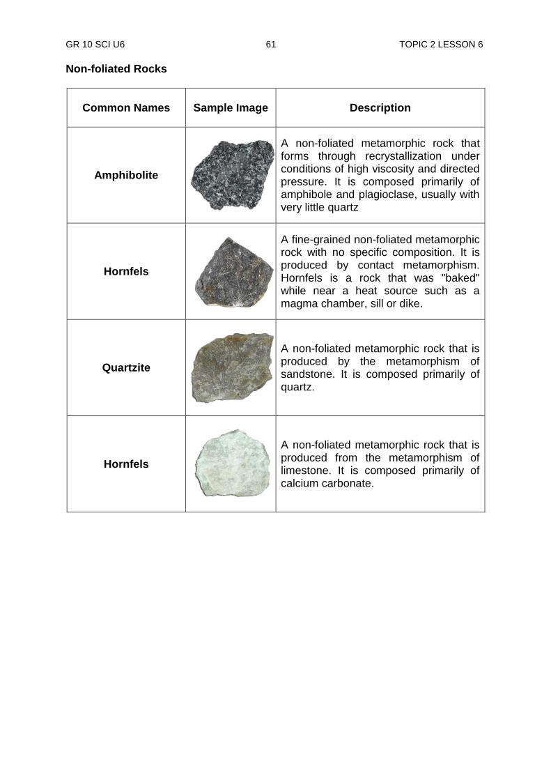
GR 10 SCI U6 61 TOPIC 2 LESSON 6
Non-foliated Rocks
Common Names
Sample Image Description
Amphibolite
A non-foliated metamorphic rock that forms through recrystallization under conditions of high viscosity and directed pressure. It is composed primarily of amphibole and plagioclase, usually with very little quartz
Hornfels
A fine-grained non-foliated metamorphic rock with no specific composition. It is produced by contact metamorphism. Hornfels is a rock that was "baked" while near a heat source such as a magma chamber, sill or dike.
Quartzite
A non-foliated metamorphic rock that is produced by the metamorphism of sandstone. It is composed primarily of quartz.
Hornfels
A non-foliated metamorphic rock that is produced from the metamorphism of limestone. It is composed primarily of calcium carbonate.
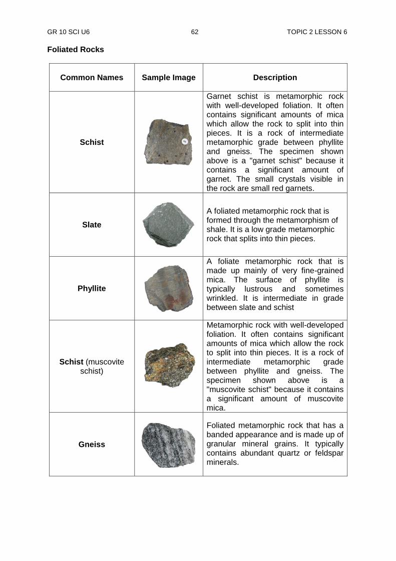
GR 10 SCI U6 62 TOPIC 2 LESSON 6
Foliated Rocks
Common Names Sample Image
Description
Schist
Garnet schist is metamorphic rock with well-developed foliation. It often contains significant amounts of mica which allow the rock to split into thin pieces. It is a rock of intermediate metamorphic grade between phyllite and gneiss. The specimen shown above is a "garnet schist" because it contains a significant amount of garnet. The small crystals visible in the rock are small red garnets.
Slate
A foliated metamorphic rock that is formed through the metamorphism of shale. It is a low grade metamorphic rock that splits into thin pieces.
Phyllite
A foliate metamorphic rock that is made up mainly of very fine-grained mica. The surface of phyllite is typically lustrous and sometimes wrinkled. It is intermediate in grade between slate and schist
Schist (muscovite schist)
Metamorphic rock with well-developed foliation. It often contains significant amounts of mica which allow the rock to split into thin pieces. It is a rock of intermediate metamorphic grade between phyllite and gneiss. The specimen shown above is a "muscovite schist" because it contains a significant amount of muscovite mica.
Gneiss
Foliated metamorphic rock that has a banded appearance and is made up of granular mineral grains. It typically contains abundant quartz or feldspar minerals.
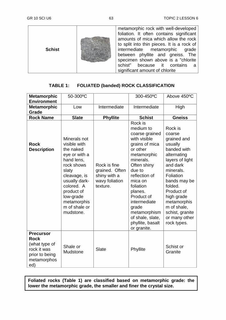
GR 10 SCI U6 63 TOPIC 2 LESSON 6
Schist
metamorphic rock with well-developed foliation. It often contains significant amounts of mica which allow the rock to split into thin pieces. It is a rock of intermediate metamorphic grade between phyllite and gneiss. The specimen shown above is a "chlorite schist" because it contains a significant amount of chlorite
TABLE 1: FOLIATED (banded) ROCK CLASSIFICATION
Metamorphic Environment
50-300ºC 300-450ºC Above 450ºC
Metamorphic Grade
Low Intermediate Intermediate High
Rock Name Slate Phyllite Schist Gneiss
Rock Description
Minerals not visible with the naked eye or with a hand lens, rock shows slaty cleavage, is usually dark-colored. A product of low-grade metamorphism of shale or mudstone.
Rock is fine grained. Often shiny with a wavy foliation texture.
Rock is medium to coarse grained with visible grains of mica or other metamorphic minerals. Often shiny due to reflection of mica on foliation planes. Product of intermediate grade metamorphism of shale, slate, phyllite, basalt or granite.
Rock is coarse grained and usually banded with alternating layers of light and dark minerals. Foliation bands may be folded. Product of high grade metamorphism of shale, schist, granite or many other rock types.
Precursor Rock (what type of rock it was prior to being metamorphosed)
Shale or Mudstone
Slate Phyllite Schist or Granite
Foliated rocks (Table 1) are classified based on metamorphic grade: the
lower the metamorphic grade, the smaller and finer the crystal size.
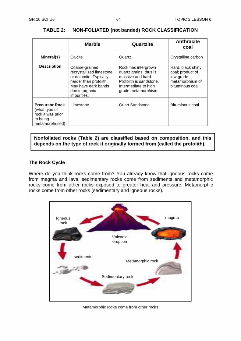
GR 10 SCI U6 64 TOPIC 2 LESSON 6
TABLE 2: NON-FOLIATED (not banded) ROCK CLASSIFICATION
Marble Quartzite
Anthracite coal
Mineral(s)
Description
Calcite
Coarse-grained recrystallized limestone or dolomite. Typically harder than protolith. May have dark bands due to organic impurities.
Quartz
Rock has intergrown quartz grains, thus is massive and hard. Protolith is sandstone. Intermediate to high grade metamorphism.
Crystalline carbon
Hard, black shiny coal; product of low-grade metamorphism of bituminous coal.
Precursor Rock (what type of rock it was prior to being metamorphosed)
Limestone
Quart Sandstone
Bituminous coal
The Rock Cycle Where do you think rocks come from? You already know that igneous rocks come from magma and lava, sedimentary rocks come from sediments and metamorphic rocks come from other rocks exposed to greater heat and pressure. Metamorphic rocks come from other rocks (sedimentary and igneous rocks).
Nonfoliated rocks (Table 2) are classified based on composition, and this
depends on the type of rock it originally formed from (called the protolith).
Igneous rock
magma
Volcanic eruption
sediments Metamorphic rock
Sedimentary rock
Metamorphic rocks come from other rocks

GR 10 SCI U6 65 TOPIC 2 LESSON 6
Where do magma and lava come from to form igneous rocks? They come from other rocks (sedimentary and metamorphic rocks). Where do sediments come from to form sedimentary rocks? They too come from other rocks (igneous and metamorphic rocks) through weathering processes. Thus, we see that rocks change from one form to another as they go through different processes. The never-ending process by which rocks are changed from one form to another is called the rock cycle. The rock cycle tells how rocks change from one form to another. Molten rock cools and hardens into igneous rock. Igneous rock breaks down to form sediments, which form sedimentary rock. Sedimentary rock then changes to form metamorphic rock. Later, metamorphic rock may change back to magma that will then harden into a new igneous rock, thus, the cycle continues. However, an igneous rock does not always break down to form sediments and a metamorphic rock does not always melt to form igneous rocks. There are shortcuts. If an igneous rock is buried, heat and pressure can change it directly into a meta-morphic rock. And a metamorphic rock can be broken down into sedimentary rock. Look at the diagram of Rock Cycle below. The rock cycle has no beginning and ending. However, scientists believe that the Earth was first made up of magma, which cooled to form igneous rocks. Therefore, the rock cycle probably got started with igneous rocks.
erosion
sediments
cooling
heat and pressure magma
melting
Metamorphic rocks
Sedimentary rocks
Igneous rocks
heat and pressure
Melting
Rock cycle
Sediments
Erosion
Erosion
Erosion
Melting
Cooling
Igneous rocks
Metamorphic rocks Sedimentary rocks
Magma
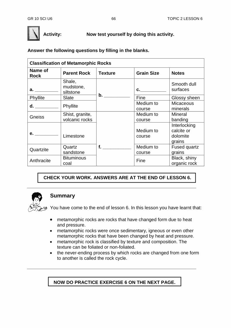
GR 10 SCI U6 66 TOPIC 2 LESSON 6
Activity: Now test yourself by doing this activity.
Answer the following questions by filling in the blanks.
Classification of Metamorphic Rocks
Name of Rock
Parent Rock Texture Grain Size Notes
a. _________
Shale, mudstone, siltstone
b. __________
c.__________
Smooth dull surfaces
Phyllite Slate Fine Glossy sheen
d. _________ Phyllite Medium to course
Micaceous minerals
Gneiss Shist, granite, volcanic rocks
f. ___________
Medium to course
Mineral banding
e. _________
Limestone
Medium to course
Interlocking calcite or dolomite grains
Quartzite Quartz sandstone
Medium to course
Fused quartz grains
Anthracite Bituminous coal
Fine Black, shiny organic rock
NOW DO PRACTICE EXERCISE 6 ON THE NEXT PAGE.
Summary You have come to the end of lesson 6. In this lesson you have learnt that:
metamorphic rocks are rocks that have changed form due to heat and pressure.
metamorphic rocks were once sedimentary, igneous or even other metamorphic rocks that have been changed by heat and pressure.
metamorphic rock is classified by texture and composition. The texture can be foliated or non-foliated.
the never-ending process by which rocks are changed from one form to another is called the rock cycle.
CHECK YOUR WORK. ANSWERS ARE AT THE END OF LESSON 6.
GR 10 SCI U6 67 TOPIC 2 LESSON 6
Practice Exercise 6
Answer the following questions on the spaces provided. 1. A tadpole changes into a frog and a caterpillar changes into a butterfly. Name
this process of changing from one form to another. ______________________________________________________________ 2. Name the process of changing from one form of rock to another. ______________________________________________________________ 3. List two things that cause rocks to form into metamorphic rocks. i) ______________________________ ii) ___________________________ 4. What temperature range does the metamorphic process take place? ______________________________________________________________ 5. List the two ways in which metamorphism process takes place. i) ____________________________ ii) _____________________________ 6. List the two types of metamorphic rocks. i) ____________________________ ii) _____________________________ 7. On the spaces below, draw the pattern of a rock cycle.
CHECK YOUR WORK. ANSWERS ARE AT THE END OF TOPIC 2.
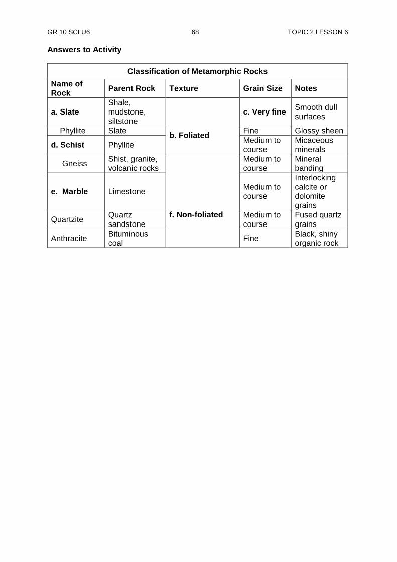
GR 10 SCI U6 68 TOPIC 2 LESSON 6
Answers to Activity
Classification of Metamorphic Rocks
Name of Rock
Parent Rock Texture Grain Size Notes
a. Slate Shale, mudstone, siltstone
b. Foliated
c. Very fine Smooth dull surfaces
Phyllite Slate Fine Glossy sheen
d. Schist Phyllite Medium to course
Micaceous minerals
Gneiss Shist, granite, volcanic rocks
f. Non-foliated
Medium to course
Mineral banding
e. Marble Limestone Medium to course
Interlocking calcite or dolomite grains
Quartzite Quartz sandstone
Medium to course
Fused quartz grains
Anthracite Bituminous coal
Fine Black, shiny organic rock
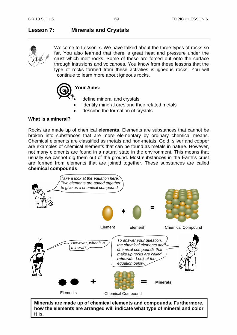
GR 10 SCI U6 69 TOPIC 2 LESSON 6
To answer your question, the chemical elements and chemical compounds that make up rocks are called minerals. Look at the equation below.
Lesson 7: Minerals and Crystals
Welcome to Lesson 7. We have talked about the three types of rocks so far. You also learned that there is great heat and pressure under the crust which melt rocks. Some of these are forced out onto the surface through intrusions and volcanoes. You know from these lessons that the type of rocks formed from these activities is igneous rocks. You will
continue to learn more about igneous rocks. What is a mineral? Rocks are made up of chemical elements. Elements are substances that cannot be broken into substances that are more elementary by ordinary chemical means. Chemical elements are classified as metals and non-metals. Gold, silver and copper are examples of chemical elements that can be found as metals in nature. However, not many elements are found in a natural state in the environment. This means that usually we cannot dig them out of the ground. Most substances in the Earth‟s crust are formed from elements that are joined together. These substances are called chemical compounds.
Element Element Chemical Compound
Take a look at the equation here. Two elements are added together
to give us a chemical compound.
However, what is a mineral?
Elements Chemical Compound
Minerals
Minerals are made up of chemical elements and compounds. Furthermore, how the elements are arranged will indicate what type of mineral and color it is.
Your Aims:
define mineral and crystals
identify mineral ores and their related metals
describe the formation of crystals
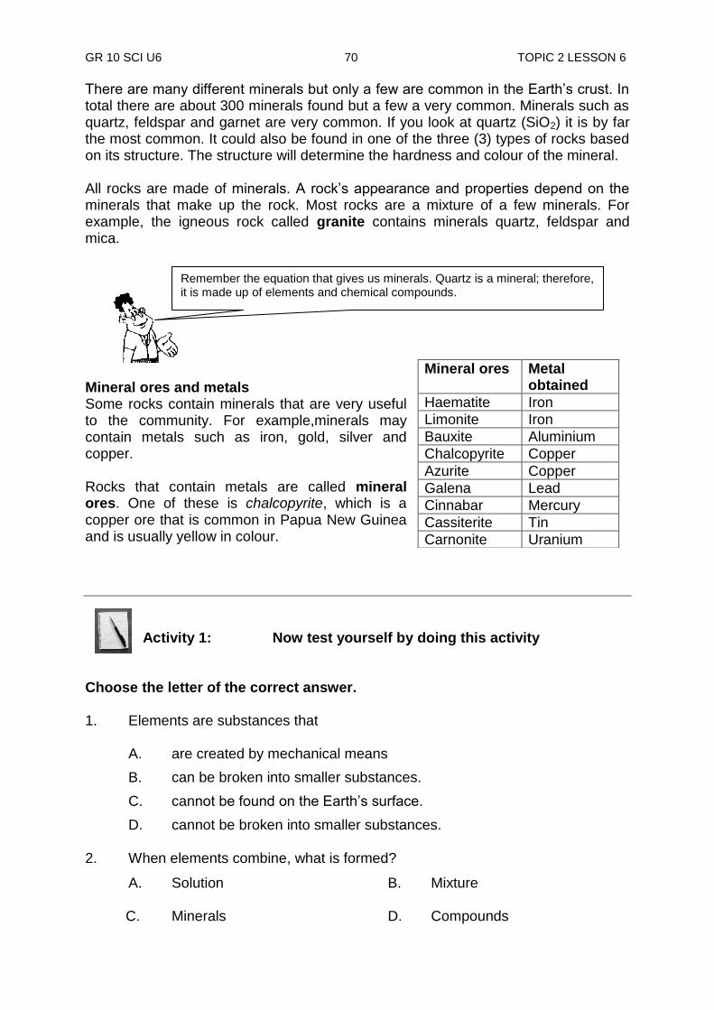
GR 10 SCI U6 70 TOPIC 2 LESSON 6
There are many different minerals but only a few are common in the Earth‟s crust. In total there are about 300 minerals found but a few a very common. Minerals such as quartz, feldspar and garnet are very common. If you look at quartz (SiO2) it is by far the most common. It could also be found in one of the three (3) types of rocks based on its structure. The structure will determine the hardness and colour of the mineral. All rocks are made of minerals. A rock‟s appearance and properties depend on the minerals that make up the rock. Most rocks are a mixture of a few minerals. For example, the igneous rock called granite contains minerals quartz, feldspar and mica.
Mineral ores and metals Some rocks contain minerals that are very useful to the community. For example,minerals may contain metals such as iron, gold, silver and copper. Rocks that contain metals are called mineral ores. One of these is chalcopyrite, which is a copper ore that is common in Papua New Guinea and is usually yellow in colour.
Activity 1: Now test yourself by doing this activity
Choose the letter of the correct answer. 1. Elements are substances that
A. are created by mechanical means
B. can be broken into smaller substances.
C. cannot be found on the Earth‟s surface.
D. cannot be broken into smaller substances. 2. When elements combine, what is formed?
A. Solution B. Mixture
C. Minerals D. Compounds
Mineral ores Metal obtained
Haematite Iron
Limonite Iron
Bauxite Aluminium
Chalcopyrite Copper
Azurite Copper
Galena Lead
Cinnabar Mercury
Cassiterite Tin
Carnonite Uranium
Remember the equation that gives us minerals. Quartz is a mineral; therefore, it is made up of elements and chemical compounds.
GR 10 SCI U6 71 TOPIC 2 LESSON 7
3. When elements and compounds are combined, what is formed? A. Gold B. Mixture C. Solution D. Minerals
4. Minerals that make up the rock, give the rocks their __________ and
__________.
A. name, origin B. origin, time C. name, identity D. appearance, property
5. A rock that contains the minerals quartz, feldspar and mica is called
A. slate. B. gabbro. C. marble. D. granite.
6. Rocks that contain metals are called
A. ore body. B. ore deposit. C. mineral ore. D. mineral deposit.
7. What metal is obtained from the mineral galena?
A. Gold B. Silver C. Lead D. Copper
8. Uranium is obtained from the mineral ore called A. carnonite. B. cinnabar C. cassiterite. D. chalcopyrite.
9. Chemical elements are classified into two groups. They are __________ and
__________.
A. metals, ores B. gases, solids C. metals, non-metals D. elements, compounds
CHECK YOUR WORK. ANSWERS ARE AT THE END OF LESSON 7.

GR 10 SCI U6 72 TOPIC 2 LESSON 7
NOW DO PRACTICE EXERCISE 7 ON THE NEXT PAGE.
Summary You have come to the end of lesson 7. In this lesson you have learnt that:
rocks are made up of chemical elements.
metals are chemical elements and they are substances that cannot be broken into substances that are more elementary by ordinary chemical means.
chemical elements make up chemical compounds.
minerals are made up of chemical elements and compounds..
there are many different minerals but only a few are common in the earth‟s crust.
a rock‟s appearance and properties depend on the minerals that make up the rock.
rocks that contain metals are called mineral ores.
GR 10 SCI U6 73 TOPIC 2 LESSON 7
Practice Exercise 7
Answer the following questions on the spaces provided. 1. What is a chemical element? ______________________________________________________________
______________________________________________________________
(i) Chemical elements are classified into two categories. What are they? __________________________________________________________________________________________________________________
(ii) What is a chemical compound?
_________________________________________________________ _________________________________________________________
2. What is a mineral?
______________________________________________________________ ______________________________________________________________
3. What is a metal?
______________________________________________________________ ______________________________________________________________
4. What is a mineral ore?
______________________________________________________________ ______________________________________________________________
(i) Name the mineral ore that contains the metal lead.
_________________________________________________________ _________________________________________________________
(ii) Name two mineral ores that contain copper.
_________________________________________________________ _________________________________________________________
5. All rocks are made up of ___________________.
(i) What metal does the mineral ore bauxite contain? _________________________________________________________
(ii) What mineral ore is the metal tin extracted from?
_________________________________________________________
CHECK YOUR ANSWERS AT THE END OF TOPIC 2.

GR 10 SCI U6 74 TOPIC 2 LESSON 7
Answers to Activity 1. D
2. D
3. D
4. D
5. D
6. C
7. C
8. A
9. C
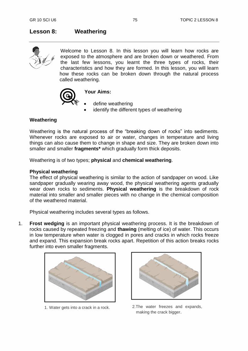
GR 10 SCI U6 75 TOPIC 2 LESSON 8
1. Water gets into a crack in a rock. 2.The water freezes and expands,
making the crack bigger.
Lesson 8: Weathering
Welcome to Lesson 8. In this lesson you will learn how rocks are exposed to the atmosphere and are broken down or weathered. From the last few lessons, you learnt the three types of rocks, their characteristics and how they are formed. In this lesson, you will learn how these rocks can be broken down through the natural process called weathering.
Weathering Weathering is the natural process of the “breaking down of rocks” into sediments. Whenever rocks are exposed to air or water, changes in temperature and living things can also cause them to change in shape and size. They are broken down into smaller and smaller fragments* which gradually form thick deposits. Weathering is of two types; physical and chemical weathering. Physical weathering The effect of physical weathering is similar to the action of sandpaper on wood. Like sandpaper gradually wearing away wood, the physical weathering agents gradually wear down rocks to sediments. Physical weathering is the breakdown of rock material into smaller and smaller pieces with no change in the chemical composition of the weathered material. Physical weathering includes several types as follows.
1. Frost wedging is an important physical weathering process. It is the breakdown of rocks caused by repeated freezing and thawing (melting of ice) of water. This occurs in low temperature when water is clogged in pores and cracks in which rocks freeze and expand. This expansion break rocks apart. Repetition of this action breaks rocks further into even smaller fragments.
Your Aims:
define weathering
identify the different types of weathering
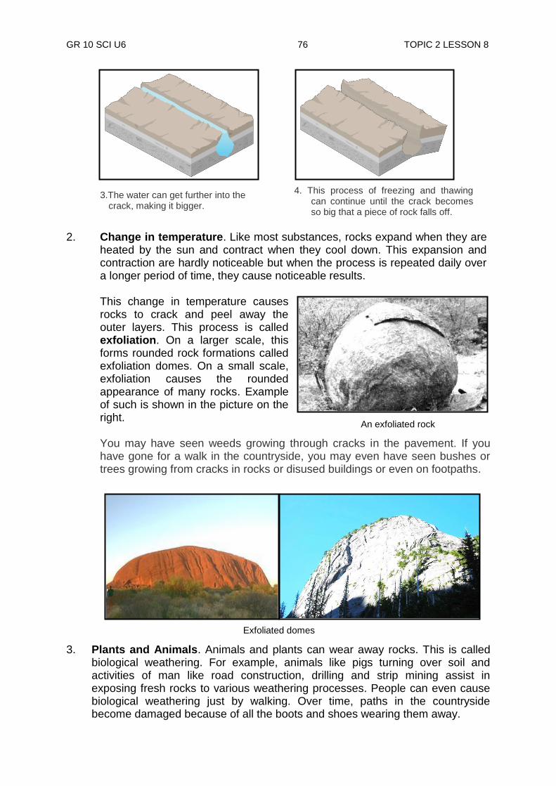
GR 10 SCI U6 76 TOPIC 2 LESSON 8
4. This process of freezing and thawing can continue until the crack becomes so big that a piece of rock falls off.
2. Change in temperature. Like most substances, rocks expand when they are
heated by the sun and contract when they cool down. This expansion and contraction are hardly noticeable but when the process is repeated daily over a longer period of time, they cause noticeable results.
This change in temperature causes rocks to crack and peel away the outer layers. This process is called exfoliation. On a larger scale, this forms rounded rock formations called exfoliation domes. On a small scale, exfoliation causes the rounded appearance of many rocks. Example of such is shown in the picture on the right.
You may have seen weeds growing through cracks in the pavement. If you have gone for a walk in the countryside, you may even have seen bushes or trees growing from cracks in rocks or disused buildings or even on footpaths.
3. Plants and Animals. Animals and plants can wear away rocks. This is called
biological weathering. For example, animals like pigs turning over soil and activities of man like road construction, drilling and strip mining assist in exposing fresh rocks to various weathering processes. People can even cause biological weathering just by walking. Over time, paths in the countryside become damaged because of all the boots and shoes wearing them away.
3.The water can get further into the
crack, making it bigger.
An exfoliated rock
Exfoliated domes

GR 10 SCI U6 77 TOPIC 2 LESSON 8
This is because plant roots can grow in cracks. As they grow bigger, the roots push open the cracks and make them wider and deeper. Eventually pieces of rock may fall away. Plants break up rocks by sending their roots into cracks in a rock and finally splitting it apart.
4. Abrasion is the sanding away of a rock‟s surface by fragments carried by
running streams, sea waves and wind. 5. Landslides break down rocks and expose them to other weathering processes
to work on them.
5. Seismic activity (earthquakes) breaks down rocks, especially, between faults where one bond of rock slide against another.
Animals turning over soil
Plants roots splitting rock
Landslide
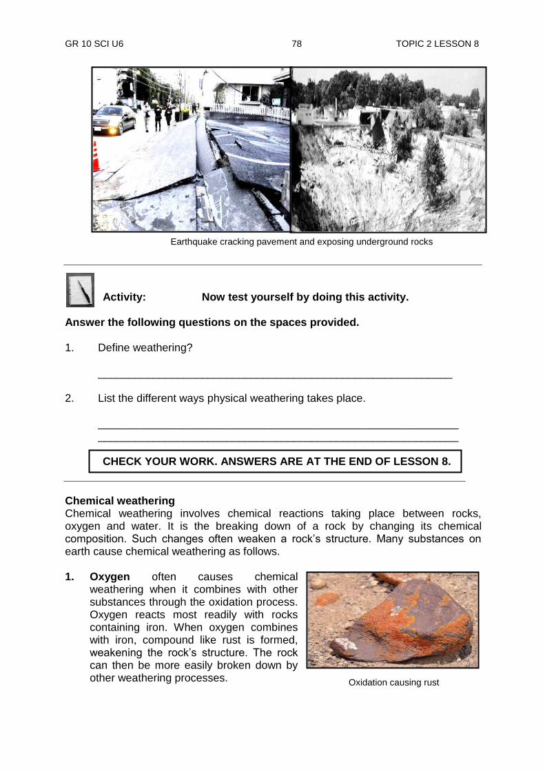
GR 10 SCI U6 78 TOPIC 2 LESSON 8
Oxidation causing rust
Activity: Now test yourself by doing this activity.
Answer the following questions on the spaces provided. 1. Define weathering?
__________________________________________________________
2. List the different ways physical weathering takes place.
___________________________________________________________ ___________________________________________________________
Chemical weathering Chemical weathering involves chemical reactions taking place between rocks, oxygen and water. It is the breaking down of a rock by changing its chemical composition. Such changes often weaken a rock‟s structure. Many substances on earth cause chemical weathering as follows. 1. Oxygen often causes chemical
weathering when it combines with other substances through the oxidation process. Oxygen reacts most readily with rocks containing iron. When oxygen combines with iron, compound like rust is formed, weakening the rock‟s structure. The rock can then be more easily broken down by other weathering processes.
Earthquake cracking pavement and exposing underground rocks
CHECK YOUR WORK. ANSWERS ARE AT THE END OF LESSON 8.
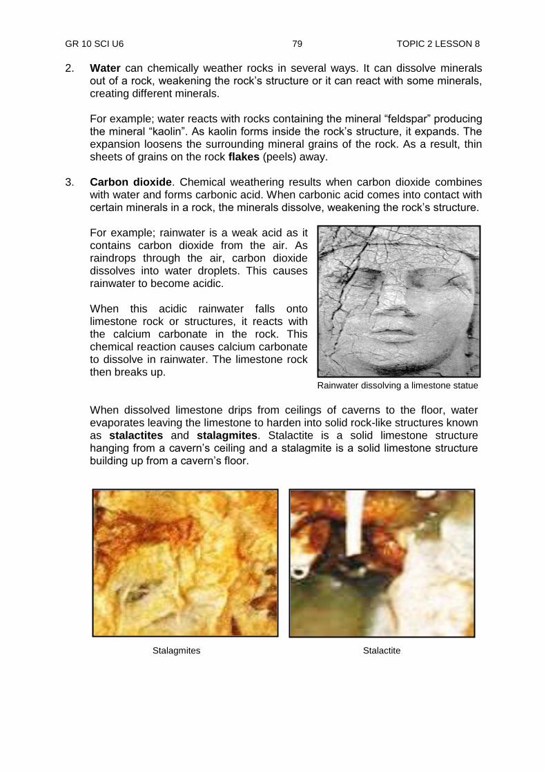
GR 10 SCI U6 79 TOPIC 2 LESSON 8
Rainwater dissolving a limestone statue
2. Water can chemically weather rocks in several ways. It can dissolve minerals out of a rock, weakening the rock‟s structure or it can react with some minerals, creating different minerals.
For example; water reacts with rocks containing the mineral “feldspar” producing the mineral “kaolin”. As kaolin forms inside the rock‟s structure, it expands. The expansion loosens the surrounding mineral grains of the rock. As a result, thin sheets of grains on the rock flakes (peels) away.
3. Carbon dioxide. Chemical weathering results when carbon dioxide combines
with water and forms carbonic acid. When carbonic acid comes into contact with certain minerals in a rock, the minerals dissolve, weakening the rock‟s structure.
For example; rainwater is a weak acid as it contains carbon dioxide from the air. As raindrops through the air, carbon dioxide dissolves into water droplets. This causes rainwater to become acidic.
When this acidic rainwater falls onto limestone rock or structures, it reacts with the calcium carbonate in the rock. This chemical reaction causes calcium carbonate to dissolve in rainwater. The limestone rock then breaks up.
When dissolved limestone drips from ceilings of caverns to the floor, water evaporates leaving the limestone to harden into solid rock-like structures known as stalactites and stalagmites. Stalactite is a solid limestone structure hanging from a cavern‟s ceiling and a stalagmite is a solid limestone structure building up from a cavern‟s floor.
Stalagmites Stalactites

GR 10 SCI U6 80 TOPIC 2 LESSON 8
4. Other acids also dissolve in water and when soaked into rocks, they react weakening the rock. The most important factors of weathering is climate. Moisture and high temperatures favour chemical reactions. In PNG, chemical weathering is more serious than physical weathering. This is because PNG has high rainfalls, high humidity and fairly high temperatures.
Eventually, all processes of weathering leads to the formation of soil which will be your next lesson.
NOW DO PRACTICE EXERCISE 8 ON THE NEXT PAGE.
Summary You have come to the end of lesson 8. In this lesson you have learnt that:
weathering is the natural process of the “breaking down of rocks” into sediments
physical and chemical weathering are the two types of weathering
the different types of physical weathering are; Frost wedging, plants and animals/biological, temperature, landslips, seismic activity, Abrasions.
chemical weathering is the breaking down of a rock by changing its chemical composition
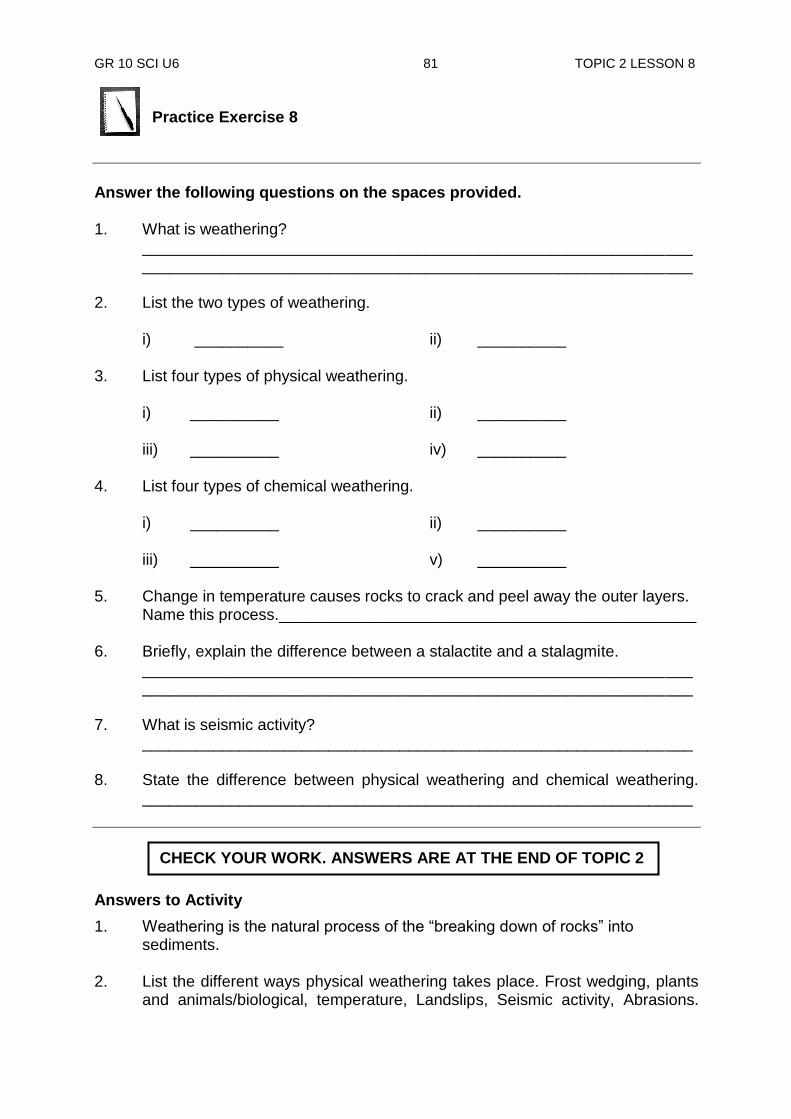
GR 10 SCI U6 81 TOPIC 2 LESSON 8
Practice Exercise 8
Answer the following questions on the spaces provided. 1. What is weathering?
______________________________________________________________ ______________________________________________________________
2. List the two types of weathering.
i) __________ ii) __________ 3. List four types of physical weathering.
i) __________ ii) __________ iii) __________ iv) __________ 4. List four types of chemical weathering. i) __________ ii) __________ iii) __________ v) __________ 5. Change in temperature causes rocks to crack and peel away the outer layers.
Name this process._______________________________________________ 6. Briefly, explain the difference between a stalactite and a stalagmite. ______________________________________________________________
______________________________________________________________ 7. What is seismic activity? ______________________________________________________________ 8. State the difference between physical weathering and chemical weathering.
______________________________________________________________
Answers to Activity
1. Weathering is the natural process of the “breaking down of rocks” into sediments. 2. List the different ways physical weathering takes place. Frost wedging, plants
and animals/biological, temperature, Landslips, Seismic activity, Abrasions.
CHECK YOUR WORK. ANSWERS ARE AT THE END OF TOPIC 2

GR 10 SCI U6 82 TOPIC 2 LESSON 9
Lesson 9: Soil - A Product of Weathering
Welcome to Lesson 9. In the previous lesson you learnt about the methods in which rocks are broken down by the process of weathering. In this lesson, you will learn more about how soil is formed from rocks. You know that weathering is the break-down of rocks through the different processes from your last lesson. In this lesson, you will study soil, the product of the weathering process and its uses.
What is Soil? Soil is a product of the processes of weathering. It is a mixture of weathered rocks and humus (plant and animal remains). Humus mixes with clay and weathered sediments, adding nutrients to the soil which enriches it. Other substances such as air, water and living things can also be found in soil. Importance of soil Soil is very important as all living things depend very much upon it. Soil contains water and all other necessary minerals plants require to make their food. Animals directly or indirectly, depend on plants for food. Thus, soil is necessary for life to exist. Formation of soil It takes hundreds of thousands of years for soil to form. Soil is formed in two ways. The first way is called residual soil.
This is when the parent rock is weathered down and soil is formed directly over it or at its base. The second way is when soil is formed from weathered rock. Sediments are carried away from its parent material by the agents of erosion like wind, water and temperature. (You will learn more about these agents in the next lesson.)
Your Aims:
define soil
describe the formation of soil
describe the soil profile
label the structures of soil
Residual soil being formed at the base of a parent rock
Soil: a product of weathering

GR 10 SCI U6 83 TOPIC 2 LESSON 9
Transported soils hat have been moved from their original location.
Soil is carried down from mountains and valleys and deposited far away at lower areas. This type of soil formation is called transported soil. The composition of transported soil may be different from the rock beneath it. Large plains and deltas are formed in this way. Soon, plants begin to grow in the new soil and animals begin to move in to live on the plants. Their wastes and remains mix with the soil and further enriches it. Soil Profile Most rocks are covered by a layer of soil formed by the weathering of rocks. Soil is not the same throughout. As it forms, soil settles down forming different layers giving a soil profile. A soil profile is a cross section through the soil which reveals its horizons (layers). The figures below each show a soil profile. Generally, there are three layers in a soil profile; the topsoil, the subsoil and the parent rock. Topsoil and subsoil layers vary in depth from a few centimetres to a metre or more. After rain, water soaks through the topsoil. When this happens, minerals and tiny clay particles are washed down to lower layers in a process called leaching. Cross-section of soil
As soil develops, it forms distinct layers. Each layer can have a different colour, texture, and mineral content.
A soil profile (Notice the change in the size of rock fragments
solid rock
cracked rock
subsoil
soil
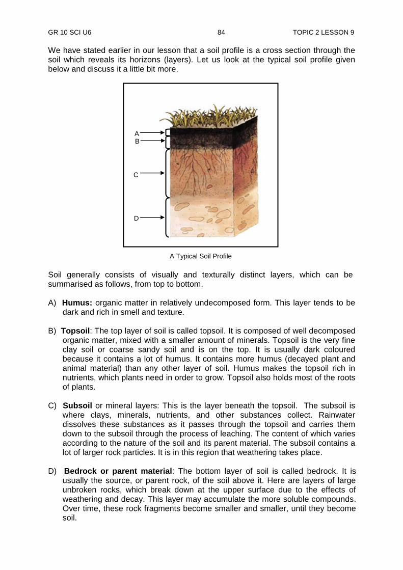
GR 10 SCI U6 84 TOPIC 2 LESSON 9
We have stated earlier in our lesson that a soil profile is a cross section through the soil which reveals its horizons (layers). Let us look at the typical soil profile given below and discuss it a little bit more. Soil generally consists of visually and texturally distinct layers, which can be summarised as follows, from top to bottom. A) Humus: organic matter in relatively undecomposed form. This layer tends to be
dark and rich in smell and texture. B) Topsoil: The top layer of soil is called topsoil. It is composed of well decomposed
organic matter, mixed with a smaller amount of minerals. Topsoil is the very fine clay soil or coarse sandy soil and is on the top. It is usually dark coloured because it contains a lot of humus. It contains more humus (decayed plant and animal material) than any other layer of soil. Humus makes the topsoil rich in nutrients, which plants need in order to grow. Topsoil also holds most of the roots of plants.
C) Subsoil or mineral layers: This is the layer beneath the topsoil. The subsoil is
where clays, minerals, nutrients, and other substances collect. Rainwater dissolves these substances as it passes through the topsoil and carries them down to the subsoil through the process of leaching. The content of which varies according to the nature of the soil and its parent material. The subsoil contains a lot of larger rock particles. It is in this region that weathering takes place.
D) Bedrock or parent material: The bottom layer of soil is called bedrock. It is
usually the source, or parent rock, of the soil above it. Here are layers of large unbroken rocks, which break down at the upper surface due to the effects of weathering and decay. This layer may accumulate the more soluble compounds. Over time, these rock fragments become smaller and smaller, until they become soil.
A B
C
D
A Typical Soil Profile
GR 10 SCI U6 85 TOPIC 2 LESSON 9
So soil takes many thousands of years to form but can be eroded by rain overnight if it is not protected. In your next lesson, you will look at how soil is eroded and transported away.
NOW DO PRACTICE EXERCISE 9 ON THE NEXT PAGE.
Summary You have come to the end of lesson 9. In this lesson you have learnt that:
soil is a product of the processes of weathering.
soil is formed in two ways, by residual soil and by transported soil.
a soil profile is a cross section through the soil which reveals its horizons (layers).
generally, there are three layers in a soil profile; the topsoil, subsoil and parent rock.
GR 10 SCI U6 86 TOPIC 2 LESSON 9
Practice Exercise 9
Answer the following questions on the spaces provided for. 1. What makes up a soil? ______________________________________________________________ 2. List one reason why soil is so important. ____________________________________________________________ 3. Briefly, explain the difference between residual soil and transported soil ______________________________________________________________ ______________________________________________________________ ______________________________________________________________ 4. Explain in your own words of what is meant by leaching. ______________________________________________________________ ______________________________________________________________ 5. Label the layers the soil profile in the picture below. Write the correct names
on the space provided in the next page.
A B
C
D

GR 10 SCI U6 87 TOPIC 2 LESSON 9
A. _____________________________ B. _____________________________ C. _____________________________ D. _____________________________
CHECK YOUR WORK ANSWERS AT THE END OF TOPIC 2.

GR 10 SCI U6 88 TOPIC 2 LESSON 10
What is soil erosion? What happens to this soil when it is not protected?
Lesson 10: Soil Erosion
In the previous lesson, you studied soil, as the main product of the weathering process. You learnt about the formation of the rock and labelled the soil profile. From these lessons you should be able to understand soil erosion.
Soil Erosion Many processes work together in changing the shape of the earth‟s surface. Soil erosion is one of these processes.
If soil is not protected, it is soon carried away. The movement of rock particles to a new location is called soil erosion. Erosion is defined as the removal of soil, sediment, regolith (it is horizon C of the soil profile which is not the parent rock, but made up of soil produced by other agents of weathering), and rock fragments from the landscape.
In order for erosion to occur, three processes must take place: 1. Detachment
Detachment is the actual removal of particles from its source.
2. Entrainment Entrainment is the mixing of the particles with agents of erosion such as wind, water, air and ice.
3. Transport Transportation is the movement of the particles by its agent of erosion.
Your Aims:
define soil erosion
identify the agents of soil erosion
describe factors that affect soil erosion
Erosion taking place
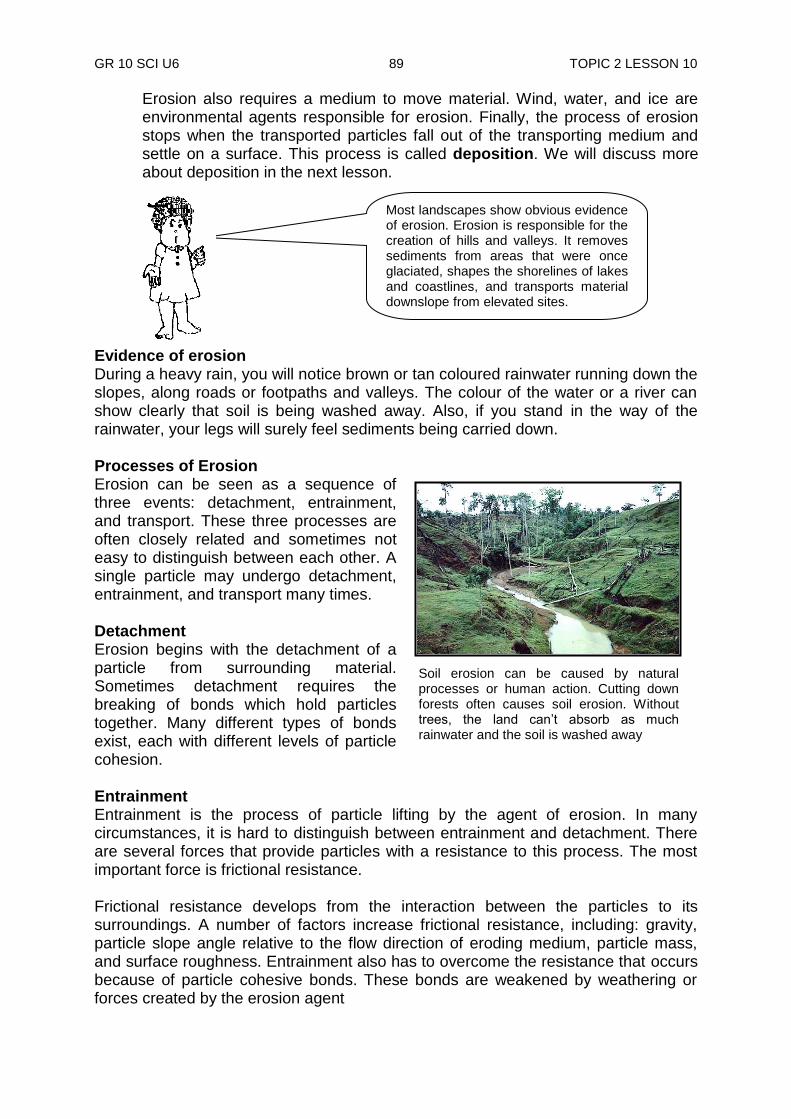
GR 10 SCI U6 89 TOPIC 2 LESSON 10
Soil erosion can be caused by natural processes or human action. Cutting down forests often causes soil erosion. Without trees, the land can‟t absorb as much rainwater and the soil is washed away
Erosion also requires a medium to move material. Wind, water, and ice are environmental agents responsible for erosion. Finally, the process of erosion stops when the transported particles fall out of the transporting medium and settle on a surface. This process is called deposition. We will discuss more about deposition in the next lesson.
Evidence of erosion During a heavy rain, you will notice brown or tan coloured rainwater running down the slopes, along roads or footpaths and valleys. The colour of the water or a river can show clearly that soil is being washed away. Also, if you stand in the way of the rainwater, your legs will surely feel sediments being carried down. Processes of Erosion Erosion can be seen as a sequence of three events: detachment, entrainment, and transport. These three processes are often closely related and sometimes not easy to distinguish between each other. A single particle may undergo detachment, entrainment, and transport many times. Detachment Erosion begins with the detachment of a particle from surrounding material. Sometimes detachment requires the breaking of bonds which hold particles together. Many different types of bonds exist, each with different levels of particle cohesion. Entrainment Entrainment is the process of particle lifting by the agent of erosion. In many circumstances, it is hard to distinguish between entrainment and detachment. There are several forces that provide particles with a resistance to this process. The most important force is frictional resistance. Frictional resistance develops from the interaction between the particles to its surroundings. A number of factors increase frictional resistance, including: gravity, particle slope angle relative to the flow direction of eroding medium, particle mass, and surface roughness. Entrainment also has to overcome the resistance that occurs because of particle cohesive bonds. These bonds are weakened by weathering or forces created by the erosion agent
Most landscapes show obvious evidence of erosion. Erosion is responsible for the creation of hills and valleys. It removes sediments from areas that were once glaciated, shapes the shorelines of lakes and coastlines, and transports material downslope from elevated sites.

GR 10 SCI U6 90 TOPIC 2 LESSON 10
Evidence of mass wasting – The Tari landslip
Transport Once a particle is entrained, it tends to move as long as the velocity of the medium is high enough to transport the particle horizontally. Within the medium, transport can occur in four different ways as follows.
Suspension is where the particles are carried by the medium without touching the surface of their origin. This can occur in air, water, and ice.
1. Saltation is where the particle moves from the surface to the medium in quick continuous repeated cycles. The action of returning to the surface usually has enough force to cause the entrainment of new particles. This process is only active in air and water.
2. Traction is the movement of particles by rolling, sliding, and shuffling* along the eroded surface. This occurs in all erosional mediums.
3. Solution is a transport mechanism that occurs only in aqueous* environments. Solution involves the eroded material being dissolved and carried along in water as individual ions.
Gravity A force is needed to move something. The main force behind erosion is gravity. Gravity can move sediments by having a downward pull directly, or indirectly through other agents. The downward movement of rock and soil by gravity is called mass wasting. Generally, mass movement occurs when the weight (shear stress) of the surface material on the slope exceeds the restraining (shear strength) ability of that material. Rock fragments carried downhill by mass wasting pile up at the base of the slope are called a talus. If the talus is not covered by new eroded sediments, plants may take root and grow. Landslides may also cause rock fragments to fall from cliffs and bounce down steep slopes. Such movements are triggered by earthquakes or heavy rain. Once the momentum is picked, they can move huge amounts of material along their path in this way.
Particle weight, size, shape, surface configuration, and medium type are the main factors that determine which of these processes operate.
Talus
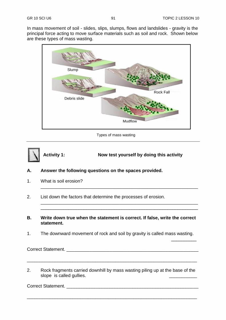
GR 10 SCI U6 91 TOPIC 2 LESSON 10
In mass movement of soil - slides, slips, slumps, flows and landslides - gravity is the principal force acting to move surface materials such as soil and rock. Shown below are these types of mass wasting.
Activity 1: Now test yourself by doing this activity
A. Answer the following questions on the spaces provided. 1. What is soil erosion? ______________________________________________________________ 2. List down the factors that determine the processes of erosion.
______________________________________________________________ ______________________________________________________________
B. Write down true when the statement is correct. If false, write the correct
statement. 1. The downward movement of rock and soil by gravity is called mass wasting. __________ Correct Statement. ____________________________________________________ ___________________________________________________________________ 2. Rock fragments carried downhill by mass wasting piling up at the base of the
slope is called gullies. ___________ Correct Statement. ____________________________________________________ ___________________________________________________________________
Slump
Rock Fall
Debris slide
Mudflow
Types of mass wasting
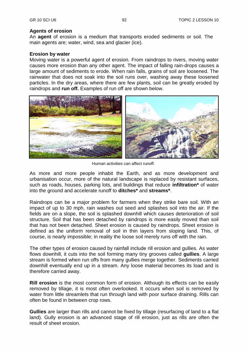
GR 10 SCI U6 92 TOPIC 2 LESSON 10
Agents of erosion An agent of erosion is a medium that transports eroded sediments or soil. The main agents are; water, wind, sea and glacier (ice). Erosion by water Moving water is a powerful agent of erosion. From raindrops to rivers, moving water causes more erosion than any other agent. The impact of falling rain-drops causes a large amount of sediments to erode. When rain falls, grains of soil are loosened. The rainwater that does not soak into the soil runs over, washing away these loosened particles. In the dry areas, where there are few plants, soil can be greatly eroded by raindrops and run off. Examples of run off are shown below.
As more and more people inhabit the Earth, and as more development and urbanisation occur, more of the natural landscape is replaced by resistant surfaces, such as roads, houses, parking lots, and buildings that reduce infiltration* of water into the ground and accelerate runoff to ditches* and streams*.
Raindrops can be a major problem for farmers when they strike bare soil. With an impact of up to 30 mph, rain washes out seed and splashes soil into the air. If the fields are on a slope, the soil is splashed downhill which causes deterioration of soil structure. Soil that has been detached by raindrops is more easily moved than soil that has not been detached. Sheet erosion is caused by raindrops. Sheet erosion is defined as the uniform removal of soil in thin layers from sloping land. This, of course, is nearly impossible; in reality the loose soil merely runs off with the rain.
The other types of erosion caused by rainfall include rill erosion and gullies. As water flows downhill, it cuts into the soil forming many tiny grooves called gullies. A large stream is formed when run offs from many gullies merge together. Sediments carried downhill eventually end up in a stream. Any loose material becomes its load and is therefore carried away. Rill erosion is the most common form of erosion. Although its effects can be easily removed by tillage, it is most often overlooked. It occurs when soil is removed by water from little streamlets that run through land with poor surface draining. Rills can often be found in between crop rows. Gullies are larger than rills and cannot be fixed by tillage (resurfacing of land to a flat land). Gully erosion is an advanced stage of rill erosion, just as rills are often the result of sheet erosion.
Human activities can affect runoff.
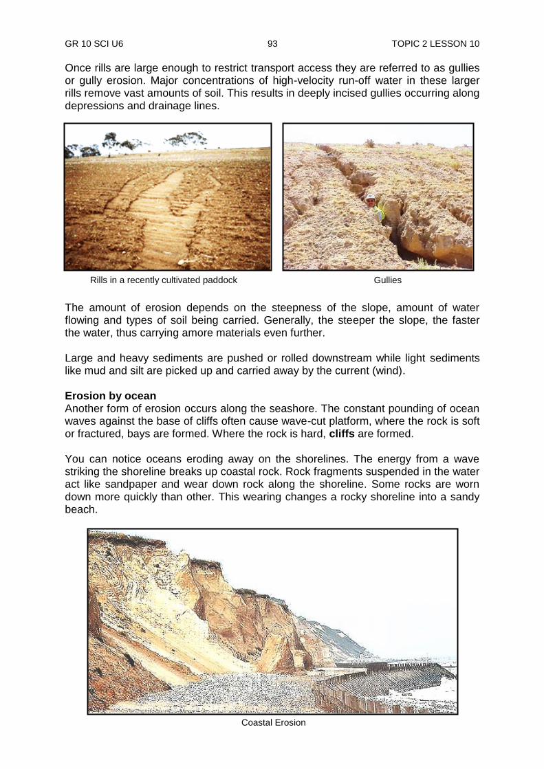
GR 10 SCI U6 93 TOPIC 2 LESSON 10
Rills in a recently cultivated paddock Gullies
Once rills are large enough to restrict transport access they are referred to as gullies or gully erosion. Major concentrations of high-velocity run-off water in these larger rills remove vast amounts of soil. This results in deeply incised gullies occurring along depressions and drainage lines.
The amount of erosion depends on the steepness of the slope, amount of water flowing and types of soil being carried. Generally, the steeper the slope, the faster the water, thus carrying amore materials even further. Large and heavy sediments are pushed or rolled downstream while light sediments like mud and silt are picked up and carried away by the current (wind). Erosion by ocean Another form of erosion occurs along the seashore. The constant pounding of ocean waves against the base of cliffs often cause wave-cut platform, where the rock is soft or fractured, bays are formed. Where the rock is hard, cliffs are formed. You can notice oceans eroding away on the shorelines. The energy from a wave striking the shoreline breaks up coastal rock. Rock fragments suspended in the water act like sandpaper and wear down rock along the shoreline. Some rocks are worn down more quickly than other. This wearing changes a rocky shoreline into a sandy beach. Coastal Erosion

GR 10 SCI U6 94 TOPIC 2 LESSON 10
Erosion by the wind Wind erosion is the movement and deposition of soil particles by wind. Wind erodes away soil by deflation (pick up and removal of sediments by wind) and abrasion (sanding down of rocks by sediment carried by the wind, water and ice). Erosion occurs when soils barren of vegetation with fewer plants to hold the soil together and are exposed to high-velocity wind. The very fine soil particles are lifted high into the atmosphere by the wind while larger sediments are rolled along close to the ground. Wind erosion, unlike water, cannot be divided into such distinct types. Occurring mostly in flat, dry areas and moist sandy soils along bodies of water, wind erosion removes soil and natural vegetation, and causes dryness and deterioration of soil structure. This is very common in the deserts. Erosion by glacier Glaciers are slow moving rivers of ice. They are very powerful and can erode land in a very short time. Sediments and exposed rocks can become frozen at the bottom and at the sides of a glacier. As the glacier moves over land, these are dragged and pushed along the edges. Unlike rivers, glaciers move straight ahead, bulldozing anything in front of them. When they move, they carve out wide and deep valleys. As a result, a glacier valley in the cross-section looks like the letter U, while river valleys look like the letter V as shown in the pictures below.
Glacial erosion
Glacier valley (U) River valley (V)
Wind erosion
GR 10 SCI U6 95 TOPIC 2 LESSON 10
Activity 2: Now test yourself by doing this activity.
Answer the following questions on the spaces provided. 1. List down the agents of erosion.
______________________________________________________________
______________________________________________________________ 2. Briefly describe the following terms;
a. Deflation ____________________________________________________________
b. Abrasion
____________________________________________________________
c. Glaciers ____________________________________________________________
Factors affecting erosion How much sediment an agent can carry, depends on several factors. 1. Medium of the agent – This is the material of the agent that carried the
sediment, such as water is the medium of streams, air is the medium of the wind, and ice is the medium of glaciers.
Each of these mediums carry varying amounts of sediments. Ice carries a far wider range of sediments than water.
2. Speed of the medium – The speed of the medium determines how much
sediment an agent can carry. The faster the medium travels the more sediment the agent can carry. The more sediment a medium carries, the more erosion takes place.
3. Sediment particles – Sediments differ in size, shape and density. These
characteristics determine how much sediments can be carried. Rivers can carry sand and other small particles farther than they can carry large rocks and so on.
CHECK YOUR WORK. ANSWERS ARE AT THE END OF LESSON 10.
GR 10 SCI U6 96 TOPIC 2 LESSON 10
NOW DO PRACTICE EXERCISE 10 ON THE NEXT PAGE.
Summary You have come to the end of lesson 10. In this lesson you have learnt that:
the movement of rock sediments to a new location is called soil erosion.
the main force behind erosion is gravity. It can move sediments by having a downward pull directly, or indirectly through other agents.
an agent of erosion is a medium that transports eroded sediments or soil.
the main agents are; river, wind, sea and glacier (ice).
some factors that affect erosion are medium of the agent, speed of the medium and sediment particles
GR 10 SCI U6 97 TOPIC 2 LESSON 10
Practice Exercise 10
Answer the following questions by filling in the blank spaces. 1. Define the following terms
i) erosion __________________________________________________________________________________________________________________
ii) load __________________________________________________________________________________________________________________
iii) run-off __________________________________________________________________________________________________________________
iv) deflation
_________________________________________________________
_________________________________________________________
v) abrasion
_________________________________________________________
_________________________________________________________
vi) talus
__________________________________________________________________________________________________________________
2. Name the force that causes landslides ______________________________________________________________ 3. Name two things that cause landslides.
i) _________________________________ ii) _________________________ 4. Name four agents of erosion.
i) _________________________________ ii) _________________________ iii) ________________________________ iv) _________________________ 5. List any three factors that determine how much sediment an agent can carry.
i) _____________________________________________________________ ii) ____________________________________________________________ iii) ____________________________________________________________

GR 10 SCI U6 98 TOPIC 2 LESSON 10
6. Label the major types of mass wasting given in the diagrams below correctly.
Answers to Activities
Activity 1
A. 1. The washing away of rock sediments to a new location is called soil
erosion. 2. (i) Detachment (ii) Entrainment (iii) Transport B. 1. True 2. False.
Rock fragments carried downhill by mass wasting piling up at the base of the slope is called a talus Activity 2 1. The agents of soil erosion are river, wind, sea and glacier (ice). 2. a. Deflation occurs when the wind picks up and removes sediments.
b. Abrasion is the sanding down of rocks by sediment carried by the wind, water and ice.
c. Glaciers are slow moving rivers of ice.
CHECK YOUR WORK. ANSWERS ARE AT THE END OF TOPIC 2.
a. __________ b. __________
c. __________ d. __________
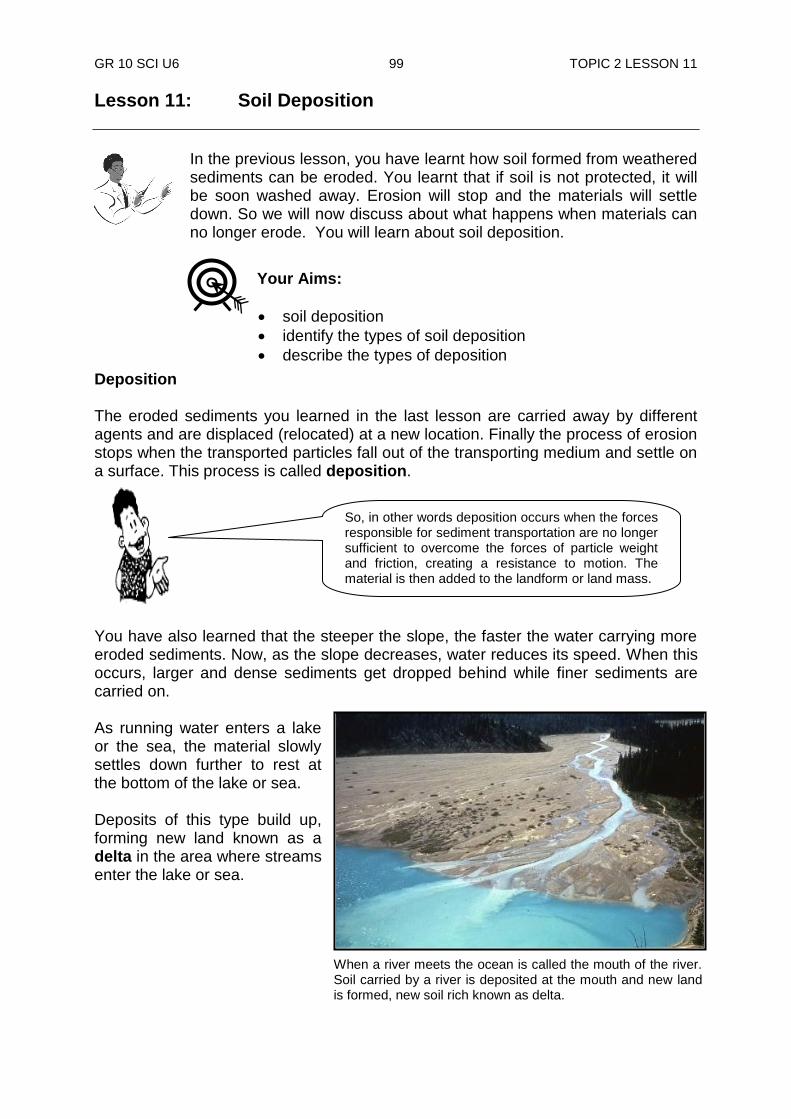
GR 10 SCI U6 99 TOPIC 2 LESSON 11
Lesson 11: Soil Deposition
In the previous lesson, you have learnt how soil formed from weathered sediments can be eroded. You learnt that if soil is not protected, it will be soon washed away. Erosion will stop and the materials will settle down. So we will now discuss about what happens when materials can no longer erode. You will learn about soil deposition.
Deposition The eroded sediments you learned in the last lesson are carried away by different agents and are displaced (relocated) at a new location. Finally the process of erosion stops when the transported particles fall out of the transporting medium and settle on a surface. This process is called deposition. You have also learned that the steeper the slope, the faster the water carrying more eroded sediments. Now, as the slope decreases, water reduces its speed. When this occurs, larger and dense sediments get dropped behind while finer sediments are carried on. As running water enters a lake or the sea, the material slowly settles down further to rest at the bottom of the lake or sea. Deposits of this type build up, forming new land known as a delta in the area where streams enter the lake or sea.
So, in other words deposition occurs when the forces responsible for sediment transportation are no longer sufficient to overcome the forces of particle weight and friction, creating a resistance to motion. The material is then added to the landform or land mass.
Your Aims:
soil deposition
identify the types of soil deposition
describe the types of deposition
When a river meets the ocean is called the mouth of the river. Soil carried by a river is deposited at the mouth and new land is formed, new soil rich known as delta.
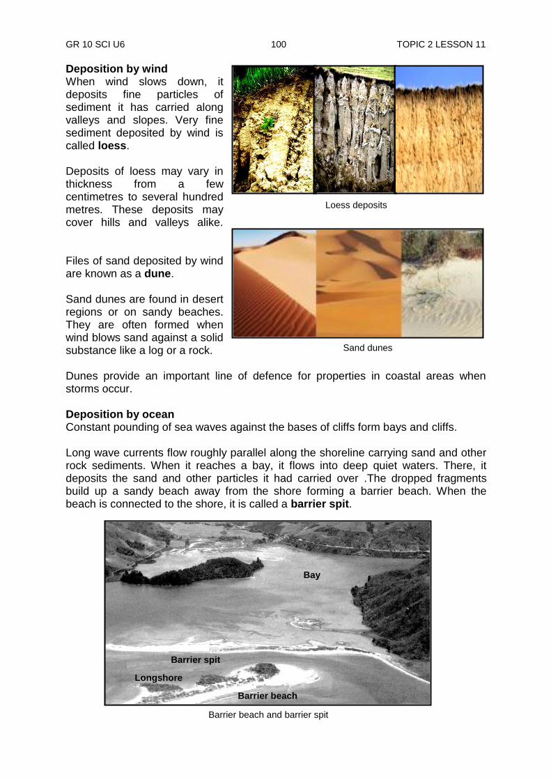
GR 10 SCI U6 100 TOPIC 2 LESSON 11
Deposition by wind When wind slows down, it deposits fine particles of sediment it has carried along valleys and slopes. Very fine sediment deposited by wind is called loess. Deposits of loess may vary in thickness from a few centimetres to several hundred metres. These deposits may cover hills and valleys alike.
Files of sand deposited by wind are known as a dune. Sand dunes are found in desert regions or on sandy beaches. They are often formed when wind blows sand against a solid substance like a log or a rock. Dunes provide an important line of defence for properties in coastal areas when storms occur. Deposition by ocean Constant pounding of sea waves against the bases of cliffs form bays and cliffs. Long wave currents flow roughly parallel along the shoreline carrying sand and other rock sediments. When it reaches a bay, it flows into deep quiet waters. There, it deposits the sand and other particles it had carried over .The dropped fragments build up a sandy beach away from the shore forming a barrier beach. When the beach is connected to the shore, it is called a barrier spit.
Barrier beach and barrier spit
Bay
Barrier spit
Longshore current
Barrier beach
Loess deposits
Sand dunes

GR 10 SCI U6 101 TOPIC 2 LESSON 11
Deposition by Glacier When a glacier reaches warm regions (climate), the ice gradually melts. As it melts, the sediments carried by glacier are deposited. Glacier deposited sediments are known as a drift. Glacial drifts may be sorted or unsorted into layers. An unsorted drift is called a till. A till may be formed when sediments are scrapped from the bottom of the glacier and spread across the landscape. It may also form when sediments are left behind when the glacier has melted away. Sorted drifts are glacial sediments carried down by streams from a melting glacier. This material is sorted out by the running water and deposited in layers. Deposits from streams of glacial melting water are called outwash. Outwash plains are broad areas in front of a glacier covered by outwash.
NOW DO PRACTICE EXERCISE 11 ON THE NEXT PAGE.
Summary You have come to the end of lesson 11. In this lesson you have learnt that:
deposition is when the process of erosion stops, and the transported particles fall out of the transporting medium and settle on a surface.
deposits of the type build up, forming new land known as a delta in the area where streams enter the lake or sea. The place where a river meets a lake or sea is called a delta.
deposition of sediments can be by running water, wind, ocean and glaciers.
very fine sediment deposited by wind is called loess.
files of sand deposited by wind are known as a dune.
the dropped fragments build up a sandy beach away from the shore forming a barrier beach.
when the beach is connected to the shore, it is called a barrier spit.
glacier deposited sediments are known as a drift.
glacial drifts may be sorted or unsorted into layers.
an unsorted drift is called a till.
deposits from streams of glacial melting water are called outwash.
Unsorted glacial sediment. Glacial drift is a general term for the coarsely graded and extremely heterogeneous sediments of glacial origin.

GR 10 SCI U6 102 TOPIC 2 LESSON 11
Practice Exercise 11
Answer the following questions on the spaces provided. 1. What happens to speed of water when a slope is steep?
_____________________________________________________________
2. Briefly, explain what happens when water slows down.
_____________________________________________________________
_____________________________________________________________
3. What happens to the sediments as the water enters a lake or the sea?
_____________________________________________________________
_____________________________________________________________
4. Define the following terms;
i) delta ________________________________________________________
ii) dunes
________________________________________________________ iii) loess
________________________________________________________
iv) drift ________________________________________________________
v) barrier spit
________________________________________________________
vi) till ________________________________________________________
vii) outwash
________________________________________________________
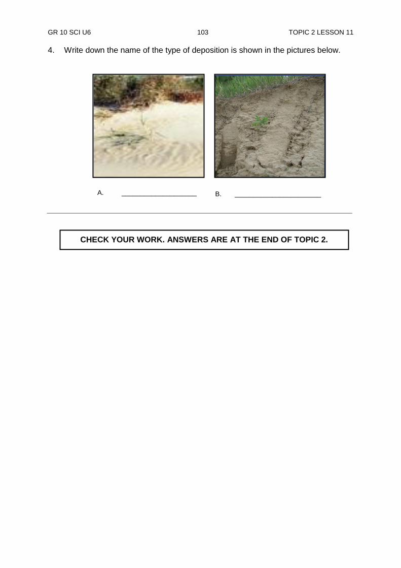
GR 10 SCI U6 103 TOPIC 2 LESSON 11
4. Write down the name of the type of deposition is shown in the pictures below.
CHECK YOUR WORK. ANSWERS ARE AT THE END OF TOPIC 2.
A. ____________________ B. _______________________
GR 10 SCI U6 104 ANSWERS TO PRACTICE EXERCISES
Answers to Practice Exercises 4 - 11 Practice Exercise 4 1. It helps the geologists to identify and classify different rock types. 2. It gives a clue of the mineral content of a rock. 3. It is formed from magma that do not flow out onto the surface. 4. It is formed from molten magma that flow onto the surface as lava through a
volcano. 5. i) granite ii) felsite 6. i) Pumice ii) a. sometimes used in movies. b. ground pumice mixed with soap for washing hands. 7. Obsidian, pumice, basalt (any two)
Practice Exercise 5 1. Weathered-down sediments 2. i) high temperature ii) high pressure 3 Compaction: a decrease in volume brought about by weight pressure. This
happens when the top layers of sediments push down on the bottom layers. As more and more layers build up, the weight squeezes the fine sediments down to stick together, forming into a sedimentary rock.
Cementation: the process whereby sediments are joined together to form
rocks. This occurs when minerals deposited between sediments. When the minerals harden, the sediments are cemented together and a solid sedimentary rock is formed
4. i) clastic: mudstone, siltstone, sandstone, conglomerate. (any two)
ii) chemical: a) stalagmites b) stalactite
iii) organic: a) fossils b) coal 5. coal 6. layered structure, fossils, shape of grain, ripple marks, mud cracks (any three)
GR 10 SCI U6 105 ANSWERS TO PRACTICE EXERCISES
sediments
erosion
erosion
erosion
melting
melting
cooling Igneous rocks
Metamorphic rocks Sedimentary rocks
magma heat and pressure
Igneous rocks
Practice Exercise 6
1. metamorphosis 2. metamorphism 3. heat, pressure, chemical action (any two) 4. 100 - 800ºC 5. i) regional metamorphism
ii) contact metamorphism 6. i) foliated metamorphic rock
ii) non-foliated metamorphic rock 7. Pattern of Rock Cycle
Practice Exercise 7 1. They are substances that cannot be broken any further by ordinary chemical
means. . (i) Elements and compounds
(ii) They are structures that are made up of more than one element chemically combined together.
2. Minerals are made up of chemical elements and compounds. 3. Metals are elements that are found in the earths‟ crust. They are also found on
the left side of the periodic table. 4. These are rocks that contain metals. (i) Galena (ii) Chalcopyrite and Azurite
GR 10 SCI U6 106 ANSWERS TO PRACTICE EXERCISES
5. Made up of chemical elements and compounds (i) Aluminium (ii) Cassiterite
Practice Exercise 8 1. Weathering is the breaking down of rocks into sediments by the natural
process. 2. i) physical weathering ii) chemical weathering 3. frost wedging, change in temperature, plants and animals, abrasion, landslide,
seismic activity (any four) 4. Oxygen, water, carbon dioxide, other acids 5. exfoliation 6. Stalactite is a solid limestone structure hanging from a caven‟s ceiling. Stalagmite is a solid limestone structure building up from a caven‟s floor. 7. Seismic activity (earthquakes) break down rocks, especially between faults
where one bond of rock slide against another. 8. Physical weathering is the breakdown of rock material into smaller pieces with
no change in the chemical composition of the weathered material. Chemical weathering involves chemical reactions taking place between rocks,
oxygen and water.
Practice Exercise 9 1. Soil is a mixture of weathered rocks and humus. 2. All living things depend very much upon it. 3. Residual soil is formed from weathered sediments carried away from its parent
material by the agents of erosion. Transported soil is carried down from mountains and valleys and deposited far away at lower areas.
4. Leaching is, when water soaking through the topsoil whereby minerals and
tiny particles are washed down to lower layers. 5. a) i) humus ii) topsoil iii) subsoil iv) bedrock or parent material

GR 10 SCI U6 107 ANSWERS TO PRACTICE EXERCISES
Practice Exercise 10 1. i) Erosion is the washing away of soil or rock sediments to a new location. ii) Load is how much (sediments) an agent carries. iii) Run-off is running rain water. iv) Deflation is the pickup and removal of sediments by wind.
v) Abrasion is the sanding down of rock sediments carried by wind, water and ice.
vi) Talus is piling up of rock fragments carried down by mass wasting at the base of the slope
2. Gravity 3. i) earthquakes ii) heavy rain 4. i) river ii) ocean iii) wind iv) glacier 5. i) medium of the agent ii) speed of the medium iii) sediments particles 6. a) Debris slide b) Slump c) Rock fall d) Mudflow
Practice Exercise 11 1. The water carrying the eroded sediments runs faster. 2. When water reduces its speed, the larger and dense sediments get dropped
behind while finer sediments are carried on. 3. The materials slowly settle down further to rest at the bottom of the lake or
sea. 4. i) delta -new land formed by deposits where streams enter the lake or sea ii) dunes - files of sand deposited by wind iii) loess -very fine sediments deposited by wind iv) drift - a glacier deposited sediments v) barrier spit- a beach connected to the shore vi) till - an unsorted drift
vii) outwash - deposits from glacial melting water 5. A. Sand dunes B. Loess deposits
REVISE TOPIC 2 USING THE MAIN POINTS ON THE NEXT PAGE.
GR 10 SCI U6 108 TOPIC 2 REVIEW
REVIEW OF TOPIC 2: Rocks and their Classifications
Now, revise all lessons in this Topic and then do ASSIGNMENT 6. Here are the main points to help you revise. Lesson 4: Igneous Rock
The word igneous means “from fire”. Igneous rocks are crystalline or glassy rocks formed by the cooling and solidification of molten magma.
Intrusive rocks are formed from slow cooling of magma; this allows crystals to form throughout the rock. Extrusive rocks form quickly usually above the surface so there is no time for visible crystals to form.
Igneous rocks can be either extrusive or intrusive based on how fast or slow the magma cools.
Igneous rocks are crystalline or glassy rocks formed by the cooling and solidification of molten magma.
Lesson 5: Sedimentary Rock
Compaction and cementation are two processes involved in the transformation of sediments into rocks along with high temperature and pressure.
Clastic sedimentary rocks such as breccia, conglomerate, sandstone and shale, are formed from mechanical or physical weathering debris; Chemical sedimentary rock is formed from minerals that were dissolved in water.
You can identify a sedimentary rock by looking at certain characteristics which are layered structure, fossils, shape of sediment particles, ripple marks and mud cracks.
Lesson 6: Metamorphic Rock
Metamorphic Rocks are rocks that have changed form due to heat and pressure.
Metamorphic rocks were once sedimentary, igneous or even other metamorphic rocks that have been changed by heat and pressure.
Metamorphic rock is classified by texture and composition. The texture can be foliated or non-foliated.
The never-ending process by which rocks are changed from one form to another is called the rock cycle.
Lesson 7: Minerals and Crystals
Rocks are made up of chemical elements.
Metals are chemical elements and they are substances that cannot be broken into substances that are more elementary by ordinary chemical means.
Chemical elements make up chemical compounds.
Minerals are made up of chemical elements and compounds.
There are many different minerals but only a few are common in the Earth‟s crust.
A rock‟s appearance and properties depend on the minerals that make up the rock.
Rocks that contain metals are called mineral ores.

GR 10 SCI U6 109 TOPIC 2 REVIEW
Lesson 8: Weathering
Weathering is the natural process of the “breaking down of rocks” into sediments.
Physical and chemical weathering are the two types of weathering
The different types of physical weathering are; Frost wedging, plants and animals/biological, temperature, landslips, Seismic activity, Abrasions.
Chemical weathering is the breaking down of a rock by changing its chemical composition.
Lesson 9: Soil – A Product of Weathering
Soil is a product of the processes of weathering.
Soil is formed in two ways, by residual soil and by transported soil.
A soil profile is a cross section through the soil which reveals its horizons (layers).
Generally, there are three layers in a soil profile; the topsoil, subsoil and parent rock.
Lesson 10: Soil Erosion
The movement of rock sediments to a new location is called soil erosion.
The main force behind erosion is gravity. Gravity can move sediments by having a downward pull directly, or indirectly through other agents.
An agent of erosion is a medium that transports eroded sediments or soil.
The main agents are river, wind, sea and glacier (ice).
Some factors that affect erosion are medium of the agent, speed of the medium and sediment particles.
Lesson 11: Soil Deposition
Deposition is when the process of erosion stops, and the transported particles fall out of the transporting medium and settle on a surface.
Deposits of the type build up, forming new land known as a delta in the area where streams enter the lake or sea. The place where a river meets a lake or sea is called a delta.
Deposition of sediments can be by running water, wind, ocean and glaciers.
Very fine sediment deposited by wind is called loess.
Files of sand deposited by wind are known as a dune.
The dropped fragments build up a sandy beach away from the shore forming a barrier beach.
When the beach is connected to the shore, it is called a barrier spit.
Glacier deposited sediments are known as a drift.
Glacial drifts may be sorted or unsorted into layers.
An unsorted drift is called a till.
Deposits from streams of glacial melting water are called outwash.
REVISE WELL AND THEN DO TOPIC TEST 2 IN YOUR ASSIGNMENT 6

110
GR 10 SCI U6 111 TITLE
TOPIC 3
GEOLOGICAL ACTIVITIES
In this topic you will learn about
isostasy theory
sea-floor spreading theory
plate tectonic theory
formation of mountains
volcanoes
earthquakes

GR 10 SCI U6 112 INTRODUCTION
INTRODUCTION TO TOPIC 3: GEOLOGICAL ACTIVITIES
The land we now stand on appears to be stable and permanent. However, we are reminded in the media, that constantly active natural processes are affecting the land: volcano erupting in Rabaul, Indonesia, earthquakes trembling in Japan, hurricanes affecting the United States mainland. By studying the basics of geology which you have started in Topics 1 and 2, it is expected that you will have a better understanding and respect for these and other forces that are found within and around our beautiful planet, Earth. The main goal of this topic is for you to be familiar with the idea that Geology affects the world around us. Geological activities are part of natural disturbance regimes in many ecosystems. But can be considered a threat if a species or habitat is damaged from other threats and has lost its resistance and is thus vulnerable to the disturbance. In this topic you will be given a thorough understanding of plate tectonics and how they affect the occurrence of earthquakes, formation of mountains and volcanoes around the world. Ask yourself the following questions as you study this topic:
How is the earth divided into tectonic plates and how the plates move in different directions and at different speeds?
Where the locations of plate boundaries and what are the effects that the different movements of these plates have on the occurrence of earthquakes and tsunami?
In this Topic, you will find the answers to these questions and all other
questions relating to geological activities.
THE EARTH‟S GEOLOGICAL ACTIVITY

GR 10 SCI U6 113 TOPIC 3 LESSON 12
Lesson 12: Isostasy Theory
Scientists believe that the earth was once one single landmass but later got split and separated into many continents. In the lessons that follow, you will learn how science tries to explain how this happened. You will start by studying one explanation as to how this happened.
Your Aims:
define isostasy theory
describe the isostasy theory
describe the continental drift theory Scientific Theories A theory is a belief. It is a carefully built out set of ideas that explain things we see happening or thought to have happened in the past. For a theory to be accepted it must be proven by tests supported by evidences. Science progresses when an existing theory is replaced by another that explains better than the present evidence. So in this lesson, we will look at a theory called Isostasy Theory. The Isostasy Theory One question early scientists asked was; “why are continents higher than the sea floors?” To answer this question, certain concepts were developed. One concept was about floating of objects as shown below. You can notice that the two objects float because they are both less dense than water. Notice also that the cork floats higher than the wood. This proves that the cork is less dense than the wood. And as the water waves move, the objects float along with it. The scientific theory called the Isostasy theory states that less dense objects float on dense objects. This theory states that the crust which is less dense is floating on the mantle. This cannot be true. How can solid crust float on the mantle? There are strengths and weakness to these theories. Let us look at the strength first. To support the theory, tests show that under high temperatures and pressure, mantle rocks are melted into molten liquid rock. You have learned this in Lesson 4 of Topic 2. That is why, the less dense crust floats on the dense mantle.
Cork
Wood
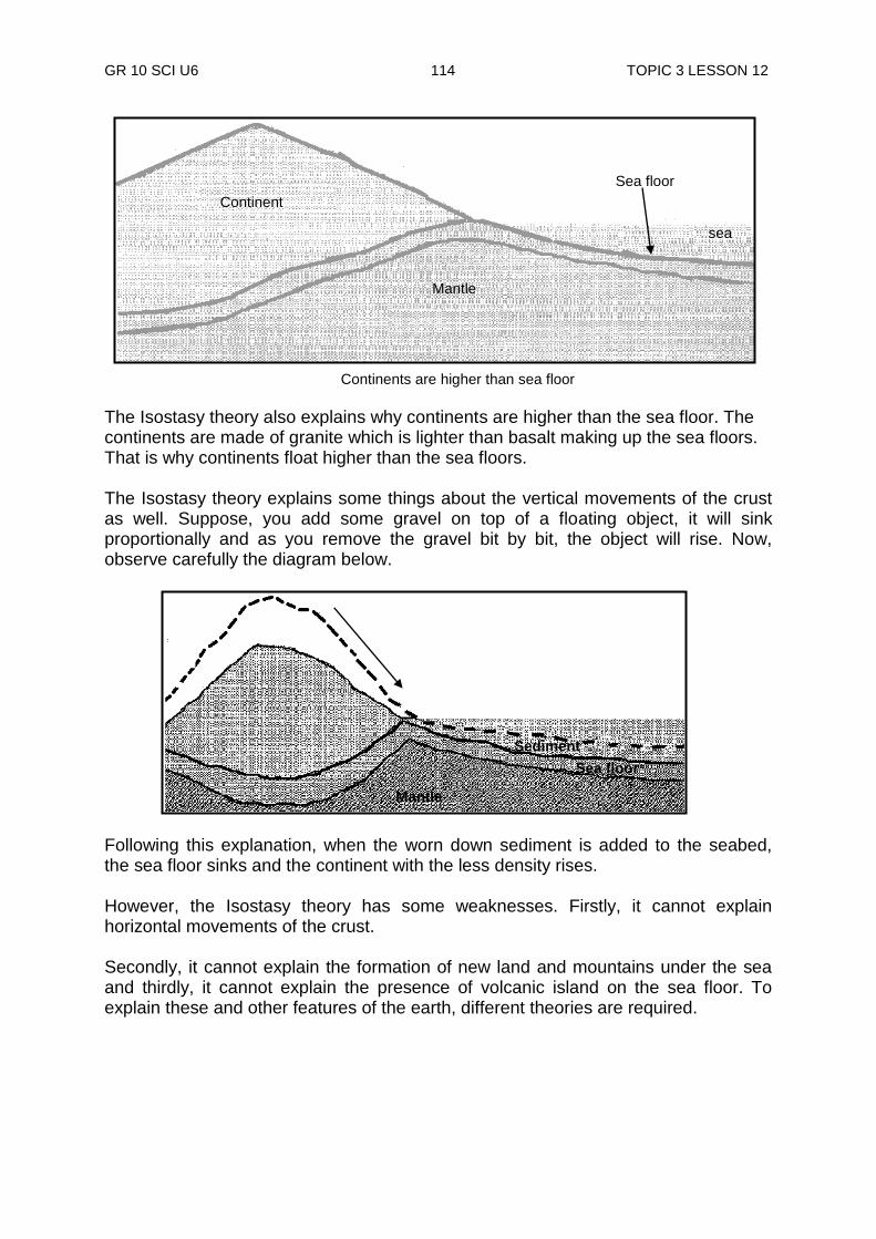
GR 10 SCI U6 114 TOPIC 3 LESSON 12
The Isostasy theory also explains why continents are higher than the sea floor. The continents are made of granite which is lighter than basalt making up the sea floors. That is why continents float higher than the sea floors. The Isostasy theory explains some things about the vertical movements of the crust as well. Suppose, you add some gravel on top of a floating object, it will sink proportionally and as you remove the gravel bit by bit, the object will rise. Now, observe carefully the diagram below.
Following this explanation, when the worn down sediment is added to the seabed, the sea floor sinks and the continent with the less density rises. However, the Isostasy theory has some weaknesses. Firstly, it cannot explain horizontal movements of the crust. Secondly, it cannot explain the formation of new land and mountains under the sea and thirdly, it cannot explain the presence of volcanic island on the sea floor. To explain these and other features of the earth, different theories are required.
Sea floor
Mantle
Sediment
Continent
Mantle
Sea floor
sea
Continents are higher than sea floor
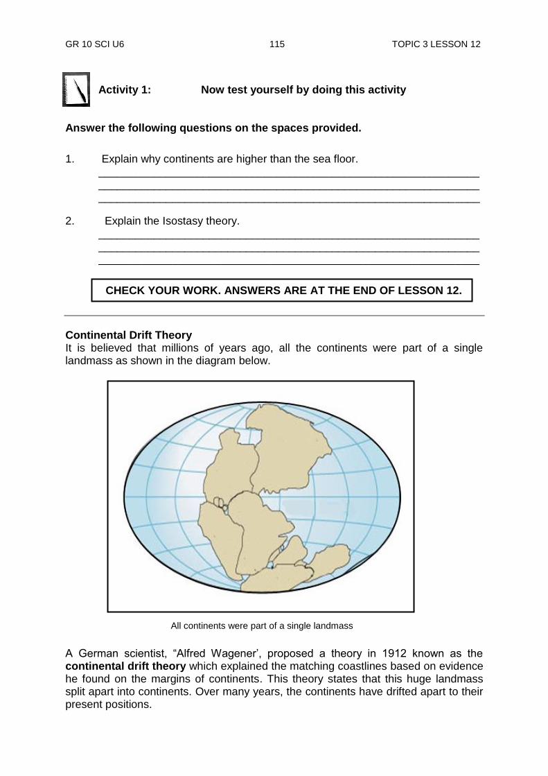
GR 10 SCI U6 115 TOPIC 3 LESSON 12
Activity 1: Now test yourself by doing this activity
Answer the following questions on the spaces provided.
1. Explain why continents are higher than the sea floor. ______________________________________________________________ ______________________________________________________________ ______________________________________________________________
2. Explain the Isostasy theory. ______________________________________________________________ ______________________________________________________________ ______________________________________________________________
Continental Drift Theory It is believed that millions of years ago, all the continents were part of a single landmass as shown in the diagram below. A German scientist, “Alfred Wagener‟, proposed a theory in 1912 known as the continental drift theory which explained the matching coastlines based on evidence he found on the margins of continents. This theory states that this huge landmass split apart into continents. Over many years, the continents have drifted apart to their present positions.
All continents were part of a single landmass
CHECK YOUR WORK. ANSWERS ARE AT THE END OF LESSON 12.
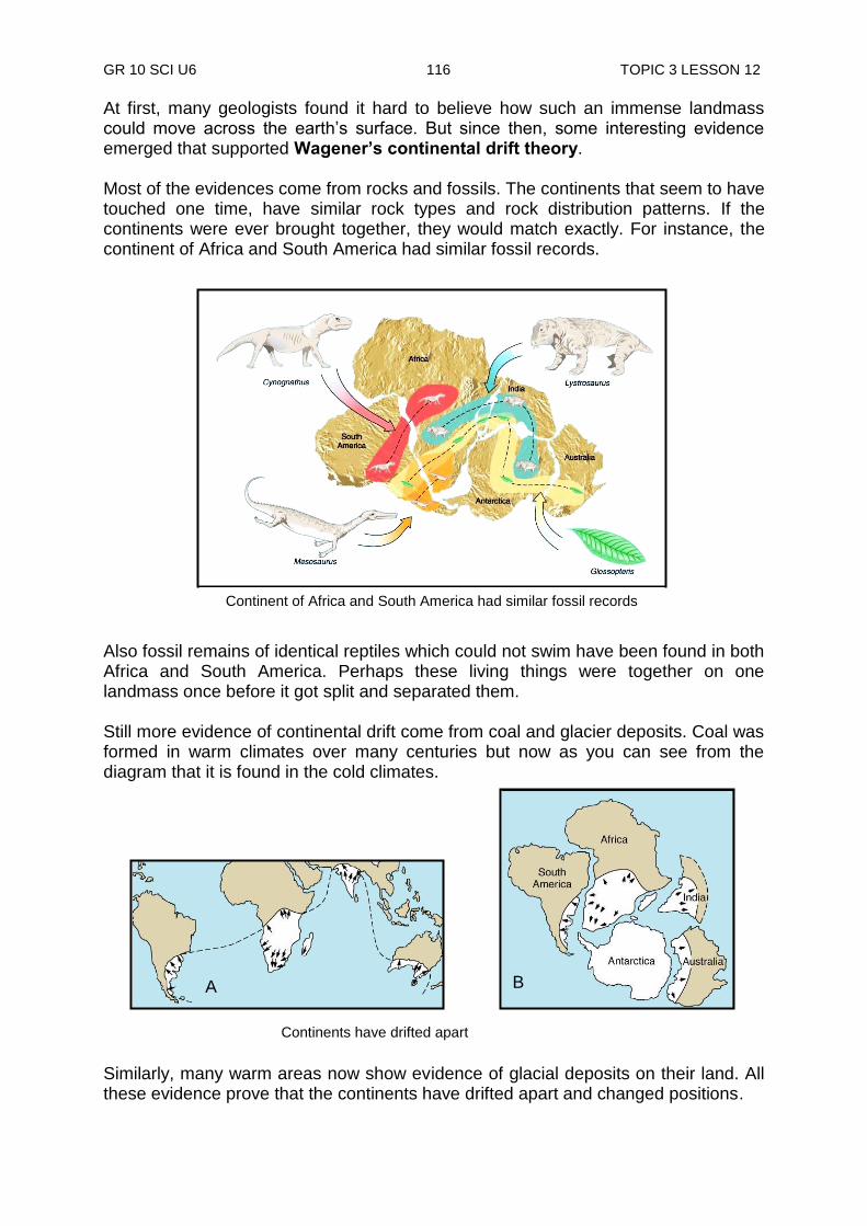
GR 10 SCI U6 116 TOPIC 3 LESSON 12
At first, many geologists found it hard to believe how such an immense landmass could move across the earth‟s surface. But since then, some interesting evidence emerged that supported Wagener’s continental drift theory. Most of the evidences come from rocks and fossils. The continents that seem to have touched one time, have similar rock types and rock distribution patterns. If the continents were ever brought together, they would match exactly. For instance, the continent of Africa and South America had similar fossil records. Also fossil remains of identical reptiles which could not swim have been found in both Africa and South America. Perhaps these living things were together on one landmass once before it got split and separated them. Still more evidence of continental drift come from coal and glacier deposits. Coal was formed in warm climates over many centuries but now as you can see from the diagram that it is found in the cold climates. Similarly, many warm areas now show evidence of glacial deposits on their land. All these evidence prove that the continents have drifted apart and changed positions.
Continent of Africa and South America had similar fossil records
A B
Continents have drifted apart
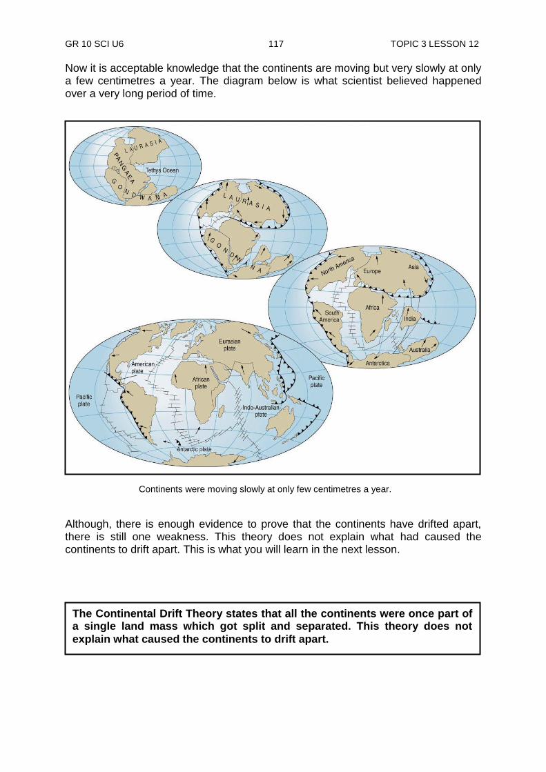
GR 10 SCI U6 117 TOPIC 3 LESSON 12
Now it is acceptable knowledge that the continents are moving but very slowly at only a few centimetres a year. The diagram below is what scientist believed happened over a very long period of time. Although, there is enough evidence to prove that the continents have drifted apart, there is still one weakness. This theory does not explain what had caused the continents to drift apart. This is what you will learn in the next lesson.
225 million years ago
135 million years ago
65 million years ago
Today
Continents were moving slowly at only few centimetres a year.
The Continental Drift Theory states that all the continents were once part of a single land mass which got split and separated. This theory does not
explain what caused the continents to drift apart.
GR 10 SCI U6 118 TOPIC 3 LESSON 12
NOW DO PRACTICE EXERCISE 12 ON THE NEXT PAGE.
Summary You have come to the end of lesson 12. In this lesson you have learnt that:
a theory is a carefully built out set of ideas that try to explain things happening or thought to have happened. A theory to be accepted, it must be proven by tests supported by evidence.
science progresses when an existing theory is replaced by another that explains better than the present evidence.
the isostasy theory states less dense objects float on dense objects.
the less dense crust is floating on the dense mantle.
all the continents were once part of a single landmass which got split and separated. This is according to the continental theory.

GR 10 SCI U6 119 TOPIC 3 LESSON 12
Practice Exercise 12
Answer the following questions on the spaces provided. 1. What is a theory? ______________________________________________________________ 2. How does Science progress? ______________________________________________________________ 3. What is meant by weakness of a theory? ______________________________________________________________ 4. Why are continents higher than sea floors? ______________________________________________________________ 5. What happens when weathered sediments are added to the sea floors? ______________________________________________________________ 6. List three weaknesses of the Isostasy Theory;
i) __________________________________________________________________________________________________________________
ii) __________________________________________________________________________________________________________________
iii) __________________________________________________________________________________________________________________
7. What does Alfred Wagener‟s continent drift theory say? ______________________________________________________________
______________________________________________________________ 8. Why did many scientists found it hard to believe Wagener‟s continental drift
theory at first? ______________________________________________________________ 9. List three evidences that supported the continental drift theory.
i)_____________________________________________________________ ii)____________________________________________________________ iii) ___________________________________________________________
GR 10 SCI U6 120 TOPIC 3 LESSON 12
10. There is enough evidence to prove that the continents have drifted apart, but there is still one weakness. Briefly, explain what the weakness is about the continental drift theory.
______________________________________________________________ ______________________________________________________________ ______________________________________________________________
Answers to Activity 1. The continents are higher than the sea floor because the continents are made of granite which is lighter than basalt making up the sea floors. That is why continents float higher than the sea floors. 2. Isostasy theory states that less dense objects float on dense objects. This theory
states that the crust which is less dense is floating on the mantle.
CHECK YOUR WORK. ANSWERS ARE AT THE END OF TOPIC 3.

GR 10 SCI U6 121 TOPIC 3 LESSON 13
Lesson 13: Sea-Floor Spreading Theory
Welcome to Lesson 13. You have studied in your last lesson, two theories which explain what makes the crust sit on the mantle, why the continents are higher than the sea floor and that the continents were once one piece of landmass but got split and moved apart some millions of years ago. But these theories could not explain what actually made the continents move apart. This is what you will learn in this lesson.
Sea Floor Spreading The ocean floors are not flat as some of us might think. Technological improvements have revealed that the ocean floor is full of mountains and valleys just like we have on land. Long underwater mountain ranges called mid-ocean ridges line the sea floor. One of these runs the entire length of the Atlantic Ocean and continues through the Indian Ocean and along the east side of the Pacific Ocean. Running along the centre of these mid-ocean ridges is a valley of deep rifts (crack). A rift valley is 1 to 2 km deep. Earthquakes and volcanic activities are common along these rifts. Also, scattered across the ocean basin along the mid-ocean ridges are thousands of underwater mountains called sea mounts. Some of these are volcanic sea mounts. Elsewhere, parts of the sea floor descend down-ward in deep channels known as trenches of which some are more than 6 km deep. A trench is a steep-walled valley on the sea floor adjacent to a continental margin. The deepest of these is more than 11 km which lie in the south-east Pacific Ocean.
Sea-floor spreading happens at the mid-oceanic ridge where a divergent boundary is causing two plates to move away from one another resulting in spreading of the sea floor. As the plates move apart, new material wells up and cools onto the edge of the plates.
Your Aims:
describe sea floor spreading theory
describe mid-ocean ridges, rifts, sea mounts and trenches
Pacific Plate
Trench Volcanoes
Nazca Plate
Seafloor spreading Subduction
Rift
Ocean floor
American Plate
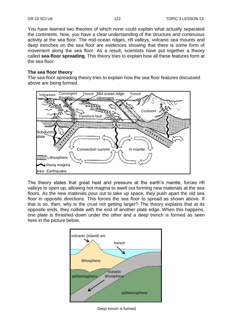
GR 10 SCI U6 122 TOPIC 3 LESSON 13
You have learned two theories of which none could explain what actually separated the continents. Now, you have a clear understanding of the structure and continuous activity at the sea floor. The mid-ocean ridges, rift valleys, volcanic sea mounts and deep trenches on the sea floor are evidences showing that there is some form of movement along the sea floor. As a result, scientists have put together a theory called sea-floor spreading. This theory tries to explain how all these features form at the sea floor. The sea floor theory The sea-floor spreading theory tries to explain how the sea floor features discussed above are being formed.
The theory states that great heat and pressure at the earth‟s mantle, forces rift valleys to open up, allowing hot magma to swell out forming new materials at the sea floors. As the new materials pour out to take up space, they push apart the old sea floor in opposite directions. This forces the sea floor to spread as shown above. If that is so, then, why is the crust not getting larger? The theory explains that at its opposite ends, they collide with the end of another plate edge. When this happens, one plate is thrashed down under the other and a deep trench is formed as seen here in the picture below.
Convection current in mantle
Lithosphere
Rising magma
Earthquake
Subducting
plate
Transform fault
Continent
Trench Volcanoes Convergent Boundary
Trench Mid ocean ridge (divergent boundary)
volcanic (island) arc
trench
asthenosphere
lithosphere
asthenosphere
oceanic lithosphere
Deep trench is formed

GR 10 SCI U6 123 TOPIC 3 LESSON 13
As the sea floor gains new materials at the ridges, it is losing old materials at the trenches. At the trenches, the old sea floor is pushed downwards. As it goes further down, it melts and become part of the molten mantle. One strength of this theory is that, ridges are pushed up by the rising of magma beneath the crust. Rifts form when this rising magma splits the crust on the sea floor. As magma pushes up through the rifts and hardens into crystal rock, the sea floor spreads. Trenches form as old sea floor bends down in response to a collision at the opposite end as mentioned above. Seismic devices have proven that crust material is indeed bending downwards in the trenches and the slipping in between of sea plates results in earthquakes and a lot of volcanic activities along these ridges. Also a lot of arc islands are formed in line, parallel to the deep sea trenches. Scientists have also measured ages of rocks on the sea floor to be much younger than rocks of the continents. Furthermore, the youngest sea floor rocks are those along the mid-ocean ridges and the older rocks are found further away as shown in the diagram below. Using deep-diving submarines, scientists are talking a closer look at the mid-ocean ridges and ocean trenches. They take samples of the sea floor to gain new information. One of the astonishing discoveries is the existence of life near active volcanic rifts. Many living things like giant clams and many others have been found living around hot water vents. This shows that life can be supported by the energy from within the earth rather than the sun. .
young
Magma rising from mantle creates new sea- floor
Mid ocean ridge
Giant clams up to 1 foot long thrive in the crevices around seafloor pillow lava, which emit hydrothermal fluids with chemical nutrients.
Rock ages of the sea floor are much younger than rocks of the continents
GR 10 SCI U6 124 TOPIC 3 LESSON 13
The only weakness in this theory is that it only explains the features of the sea floor and nothing of the continents. However, this theory has become the key to understanding all crustal movements. So how can one describe sea floor spreading?
NOW DO PRACTICE EXERCISE 13 ON THE NEXT PAGE.
Sea-floor spreading is the process in which the ocean floor is extended when two plates move apart. As the plates move apart, the rocks break and form a crack between the plates. Earthquakes occur along the plate boundary. Magma rises through the cracks and seeps out onto the
ocean floor like a long, thin, undersea volcano.
Summary You have come to end of lesson 13. In this lesson you have learnt that:
the ocean floor is full of mountains and valleys just like we have on land. The sea-floor spreading theory explains how all these features were formed.
when two plates collide, part of the sea floor is thrashed down under the other and a deep trench is formed.
the ages of rocks on the sea floor are much younger than rocks of the continents.
the ages of the rocks on the sea floor are much younger and get their energy from within the earth rather than the sun.
GR 10 SCI U6 125 TOPIC 3 LESSON 13
Practice Exercise 13
Answer the following questions on the spaces provided. 1. Define the following terms:
i) mid-ocean ridges ______________________________________________________________
ii) sea mounts ______________________________________________________________
iii) trenches _____________________________________________________________ 2. What does the sea floor spreading theory say? ______________________________________________________________ ______________________________________________________________ 3. List one strength of this theory? ______________________________________________________________ ______________________________________________________________ 4. What is one of the amazing things scientists discovered about sea floors? ______________________________________________________________ ______________________________________________________________ 5. What conclusion have they come up with from this discovery? ______________________________________________________________ ______________________________________________________________ 6. What is the weakness of this theory? ______________________________________________________________ ______________________________________________________________
CHECK YOUR WORK. ANSWERS ARE AT THE END OF TOPIC 3.

GR 10 SCI U6 126 TOPIC 3 LESSON 14
Lesson 14: Plate Tectonic Theory
Welcome to Lesson 14. You have studied three theories in your last lessons which try to explain crustal movements and some features of the sea floor. They could not explain what actually separated the continents. In this lesson, you will study yet another theory known as the Plate Tectonic Theory. This theory combines all the theories you have studied so far and come up with a model that actually explains what make the continents separate. The Plate Tectonic Theory is also known as the Unifying Theory as it combines all the three theories you have studied into one theory.
By the 1960‟s, scientists had enough evidence to believe that the continents and the sea floors are moving in many directions. This unifying theory supports the Wagener theory by stating that the crust is made up of several huge moving pieces or plates. The theory uses these plates to explain the movements of the crust. The single landmass, according to Wagener‟s theory, split into seven major and other notable minor plates. The seven (7) major plates are: 1. African plate 3. Eurasian Plate 2. Antartic plate 4. Indo – Australian plate
Your Aims:
describe the plate tectonic theory
describe plate tectonic boundaries
discuss the terms divergent boundaries, convergent boundaries and transform boundaries
describe compression, tension and shear forces
Pacific
Antartic
Map showing the plate boundaries
Direction in which plate is moving Plate boundary
Key:
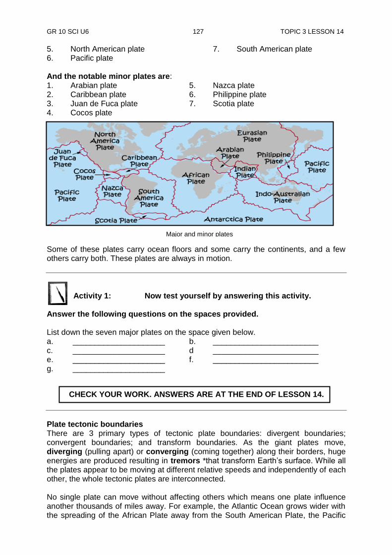
GR 10 SCI U6 127 TOPIC 3 LESSON 14
Major and minor plates
5. North American plate 7. South American plate 6. Pacific plate And the notable minor plates are: 1. Arabian plate 5. Nazca plate 2. Caribbean plate 6. Philippine plate 3. Juan de Fuca plate 7. Scotia plate 4. Cocos plate
Some of these plates carry ocean floors and some carry the continents, and a few others carry both. These plates are always in motion.
Activity 1: Now test yourself by answering this activity.
Answer the following questions on the spaces provided. List down the seven major plates on the space given below. a. _____________________ b. ________________________ c. _____________________ d ________________________ e. _____________________ f. ________________________ g. _____________________
Plate tectonic boundaries There are 3 primary types of tectonic plate boundaries: divergent boundaries; convergent boundaries; and transform boundaries. As the giant plates move, diverging (pulling apart) or converging (coming together) along their borders, huge energies are produced resulting in tremors *that transform Earth‟s surface. While all the plates appear to be moving at different relative speeds and independently of each other, the whole tectonic plates are interconnected. No single plate can move without affecting others which means one plate influence another thousands of miles away. For example, the Atlantic Ocean grows wider with the spreading of the African Plate away from the South American Plate, the Pacific
CHECK YOUR WORK. ANSWERS ARE AT THE END OF LESSON 14.
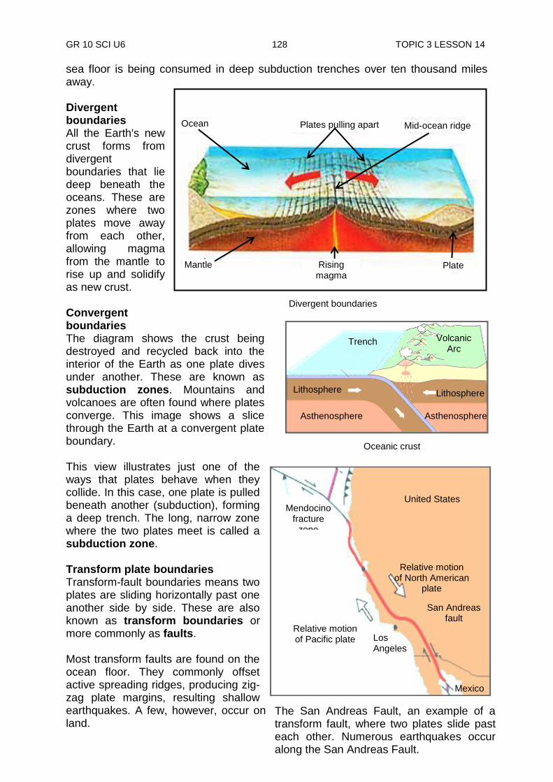
GR 10 SCI U6 128 TOPIC 3 LESSON 14
sea floor is being consumed in deep subduction trenches over ten thousand miles away. Divergent boundaries All the Earth's new crust forms from divergent boundaries that lie deep beneath the oceans. These are zones where two plates move away from each other, allowing magma from the mantle to rise up and solidify as new crust. Convergent boundaries The diagram shows the crust being destroyed and recycled back into the interior of the Earth as one plate dives under another. These are known as subduction zones. Mountains and volcanoes are often found where plates converge. This image shows a slice through the Earth at a convergent plate boundary. This view illustrates just one of the ways that plates behave when they collide. In this case, one plate is pulled beneath another (subduction), forming a deep trench. The long, narrow zone where the two plates meet is called a subduction zone. Transform plate boundaries Transform-fault boundaries means two plates are sliding horizontally past one another side by side. These are also known as transform boundaries or more commonly as faults. Most transform faults are found on the ocean floor. They commonly offset active spreading ridges, producing zig-zag plate margins, resulting shallow earthquakes. A few, however, occur on land.
San Francisco
Lithosphere
Asthenosphere Asthenosphere
Lithosphere
Volcanic Arc
Trench
Oceanic crust
Mid-ocean ridge
Plates pulling apart Ocean
Rising magma
Mantle Plate
Divergent boundaries
United States
Relative motion of North American
plate
Mendocino fracture
zone
Relative motion of Pacific plate Los
Angeles
Mexico
San Andreas fault
The San Andreas Fault, an example of a transform fault, where two plates slide past each other. Numerous earthquakes occur along the San Andreas Fault.
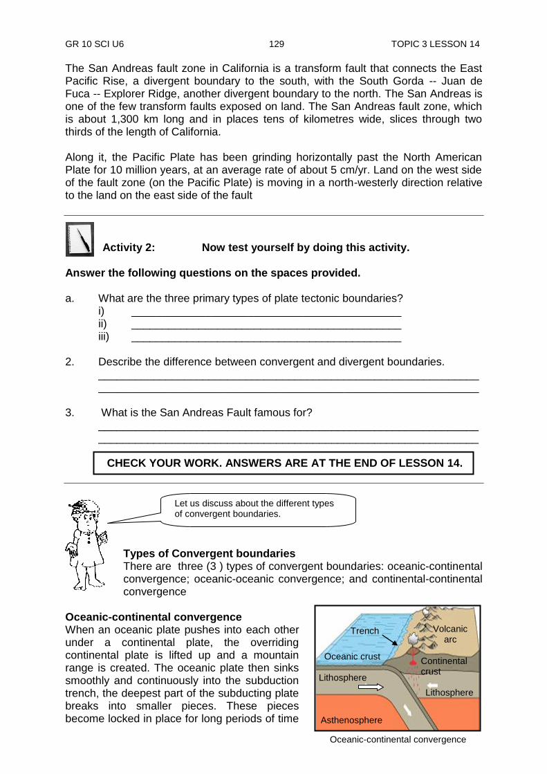
GR 10 SCI U6 129 TOPIC 3 LESSON 14
The San Andreas fault zone in California is a transform fault that connects the East Pacific Rise, a divergent boundary to the south, with the South Gorda -- Juan de Fuca -- Explorer Ridge, another divergent boundary to the north. The San Andreas is one of the few transform faults exposed on land. The San Andreas fault zone, which is about 1,300 km long and in places tens of kilometres wide, slices through two thirds of the length of California. Along it, the Pacific Plate has been grinding horizontally past the North American Plate for 10 million years, at an average rate of about 5 cm/yr. Land on the west side of the fault zone (on the Pacific Plate) is moving in a north-westerly direction relative to the land on the east side of the fault
Activity 2: Now test yourself by doing this activity.
Answer the following questions on the spaces provided. a. What are the three primary types of plate tectonic boundaries?
i) ____________________________________________ ii) ____________________________________________ iii) ____________________________________________
2. Describe the difference between convergent and divergent boundaries.
____________________________________________________________________________________________________________________________
3. What is the San Andreas Fault famous for?
____________________________________________________________________________________________________________________________
Types of Convergent boundaries There are three (3 ) types of convergent boundaries: oceanic-continental convergence; oceanic-oceanic convergence; and continental-continental convergence
Oceanic-continental convergence When an oceanic plate pushes into each other under a continental plate, the overriding continental plate is lifted up and a mountain range is created. The oceanic plate then sinks smoothly and continuously into the subduction trench, the deepest part of the subducting plate breaks into smaller pieces. These pieces become locked in place for long periods of time
Let us discuss about the different types of convergent boundaries.
Oceanic-continental convergence
Asthenosphere
Oceanic crust
Trench Volcanic arc
Lithosphere
Lithosphere
Continental crust
CHECK YOUR WORK. ANSWERS ARE AT THE END OF LESSON 14.

GR 10 SCI U6 130 TOPIC 3 LESSON 14
Continental-continental convergence
Lithosphere
Asthenosphere Ancient oceanic crust
Lithosphere
Continental crust
High Plateau
Mountain range
before moving suddenly to generate large earthquakes. Such earthquakes are often accompanied by uplift of the land by as much as a few metres. Oceanic-oceanic convergence When two oceanic plates converge, one is usually subducted under the other and in the process, a deep oceanic trench is formed. Oceanic-oceanic plate convergence also results in the formation of undersea volcanoes as shown in the diagram. Over millions of years, ago, the erupted lava and volcanic debris piled up on the ocean floor until a submarine volcano rises above the sea level to form an island volcano. Such volcanoes are typically strung out one after another called island arcs. The whole of Papua New Guinea was formed in this way, when the Australian and the Pacific plates collided some 14 million years ago. When two ocean plates collide due to a compression force, one plate is thrashed down under the other. As the thrashed plate is pushed into the mantle, it melts. As a result, a deep trench and all the other features of the ocean floor are formed. When a continental plate collides with an ocean plate under the sea due to a compression force, the dense ocean plate is usually thrashed down and a deep trench is formed. We have a deep trench of this kind south of New Britain called the New Britain Trench. Continental-continental convergence When two continents meet head-on, neither is subducted because the continental rocks are relatively light and, like two colliding icebergs, they would resist downward motion. Instead, the crust tends to buckle and is pushed upwards or sideways as shown in the diagram. This results in the formation of high plateau and young mountain ranges. Plate movement and collision The theory says that the crust also known as the lithosphere is made up several huge continental and ocean plates. These plates are being seated on the asthenosphere which is the soft fluid-like layer of magma rock in the mantle. The asthenosphere is denser than the lithosphere. Therefore, according to the Isostasy theory, the less dense plates float on the asthenosphere much like ice floating on water. This is shown in the diagrams above.
Oceanic-oceanic convergence
Tre
nch
Island arc Oceanic crust
Continental crust
Lithosphere
Lithosphere
Asthenosphere
Continental crust
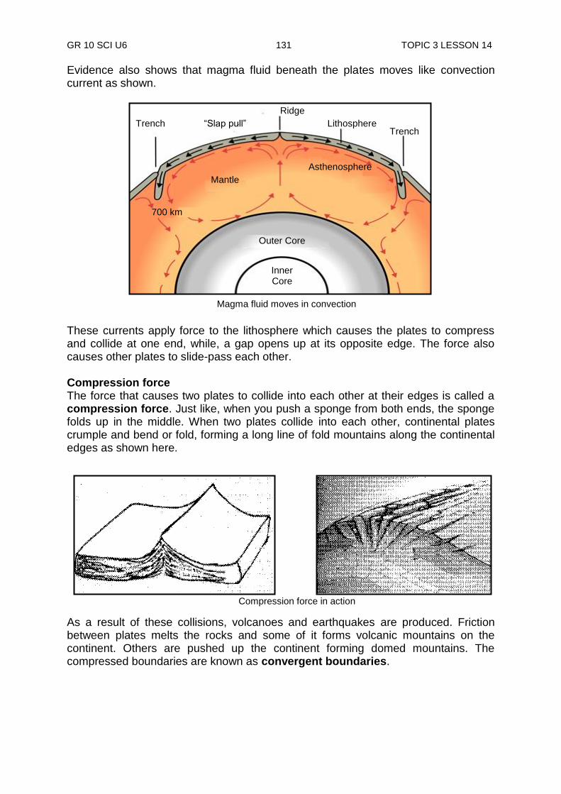
GR 10 SCI U6 131 TOPIC 3 LESSON 14
Evidence also shows that magma fluid beneath the plates moves like convection current as shown.
These currents apply force to the lithosphere which causes the plates to compress and collide at one end, while, a gap opens up at its opposite edge. The force also causes other plates to slide-pass each other. Compression force The force that causes two plates to collide into each other at their edges is called a compression force. Just like, when you push a sponge from both ends, the sponge folds up in the middle. When two plates collide into each other, continental plates crumple and bend or fold, forming a long line of fold mountains along the continental edges as shown here.
As a result of these collisions, volcanoes and earthquakes are produced. Friction between plates melts the rocks and some of it forms volcanic mountains on the continent. Others are pushed up the continent forming domed mountains. The compressed boundaries are known as convergent boundaries.
Compression force in action
Ridge
Outer Core
Inner Core
Trench
700 km
Trench
Mantle
Asthenosphere
Lithosphere “Slap pull”
Magma fluid moves in convection
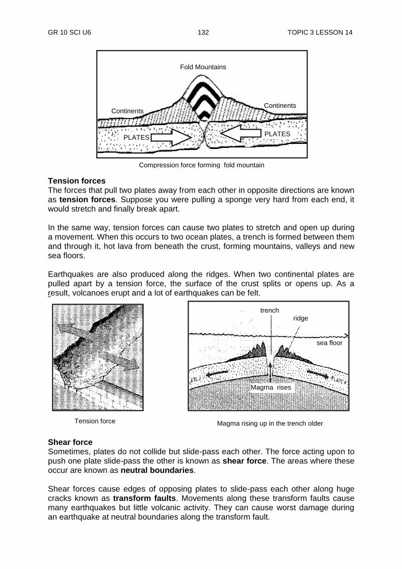
GR 10 SCI U6 132 TOPIC 3 LESSON 14
Tension forces The forces that pull two plates away from each other in opposite directions are known as tension forces. Suppose you were pulling a sponge very hard from each end, it would stretch and finally break apart. In the same way, tension forces can cause two plates to stretch and open up during a movement. When this occurs to two ocean plates, a trench is formed between them and through it, hot lava from beneath the crust, forming mountains, valleys and new sea floors. Earthquakes are also produced along the ridges. When two continental plates are pulled apart by a tension force, the surface of the crust splits or opens up. As a result, volcanoes erupt and a lot of earthquakes can be felt. Shear force Sometimes, plates do not collide but slide-pass each other. The force acting upon to push one plate slide-pass the other is known as shear force. The areas where these occur are known as neutral boundaries. Shear forces cause edges of opposing plates to slide-pass each other along huge cracks known as transform faults. Movements along these transform faults cause many earthquakes but little volcanic activity. They can cause worst damage during an earthquake at neutral boundaries along the transform fault.
Tension force
Fold Mountains
Continents Continents
PLATES PLATES
Compression force forming fold mountain
Magma rising up in the trench older
Magma rises Magma rises
trench
ridge
sea floor
Tension force
Magma rises
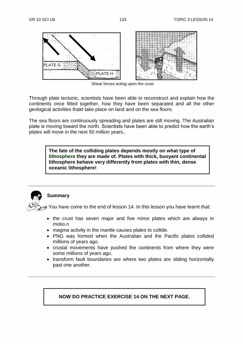
GR 10 SCI U6 133 TOPIC 3 LESSON 14
Through plate tectonic, scientists have been able to reconstruct and explain how the continents once fitted together, how they have been separated and all the other geological activities thakt take place on land and on the sea floors. The sea floors are continuously spreading and plates are still moving. The Australian plate is moving toward the north. Scientists have been able to predict how the earth‟s plates will move in the next 50 million years..
NOW DO PRACTICE EXERCISE 14 ON THE NEXT PAGE.
The fate of the colliding plates depends mostly on what type of lithosphere they are made of. Plates with thick, buoyant continental lithosphere behave very differently from plates with thin, dense
oceanic lithosphere!
Summary You have come to the end of lesson 14. In this lesson you have learnt that:
the crust has seven major and five minor plates which are always in motio.n
magma activity in the mantle causes plates to collide.
PNG was formed when the Australian and the Pacific plates collided millions of years ago.
crustal movements have pushed the continents from where they were some millions of years ago.
transform fault boundaries are where two plates are sliding horizontally past one another.
Shear forces acting upon the crust
PLATE H
PLATE G

GR 10 SCI U6 134 TOPIC 3 LESSON 14
Practice Exercise 14
1. i) Which theory is called the unifying theory? ______________________ ii) Why is it called the unifying theory? _________________________________________________________ _________________________________________________________ 2. What point of the Wagener theory is supported by this unifying theory? ______________________________________________________________ ______________________________________________________________ 3. How many plates is the lithosphere divided into? ______________________________________________________________ 4. What does the unifying theory say about these plates? ______________________________________________________________ ______________________________________________________________ 5. Name the force that causes the plates to;
i) collide into each other _________________________________________________________
ii) slide-pass each other _________________________________________________________
iii) pull in opposite directions
_________________________________________________________ 6. Which of these force causes fold mountains to form? ______________________________________________________________ 7. Name the two plates that collide on which PNG is situated.
i) _________________________________________________________ ii) _________________________________________________________
CHECK YOUR WORK. ANSWERS ARE AT THE END OF UNIT 3.
GR 10 SCI U6 135 TOPIC 3 LESSON 14
Answers to Activities Activity 1 a. African plate b. Antartic plate c.. Eurasian plate d. Indo Australian plate e. North – American plate f. Pacific plate g. South American plate Activity 2 1. Convergent boundary, divergent boundary and transform plate boundary 2. At the divergent boundaries the plates move away from each other and at the
convergent boundaries one plate is pulled beneath another (subduction), forming a deep trench.
3. Famous for the California earthquakes.
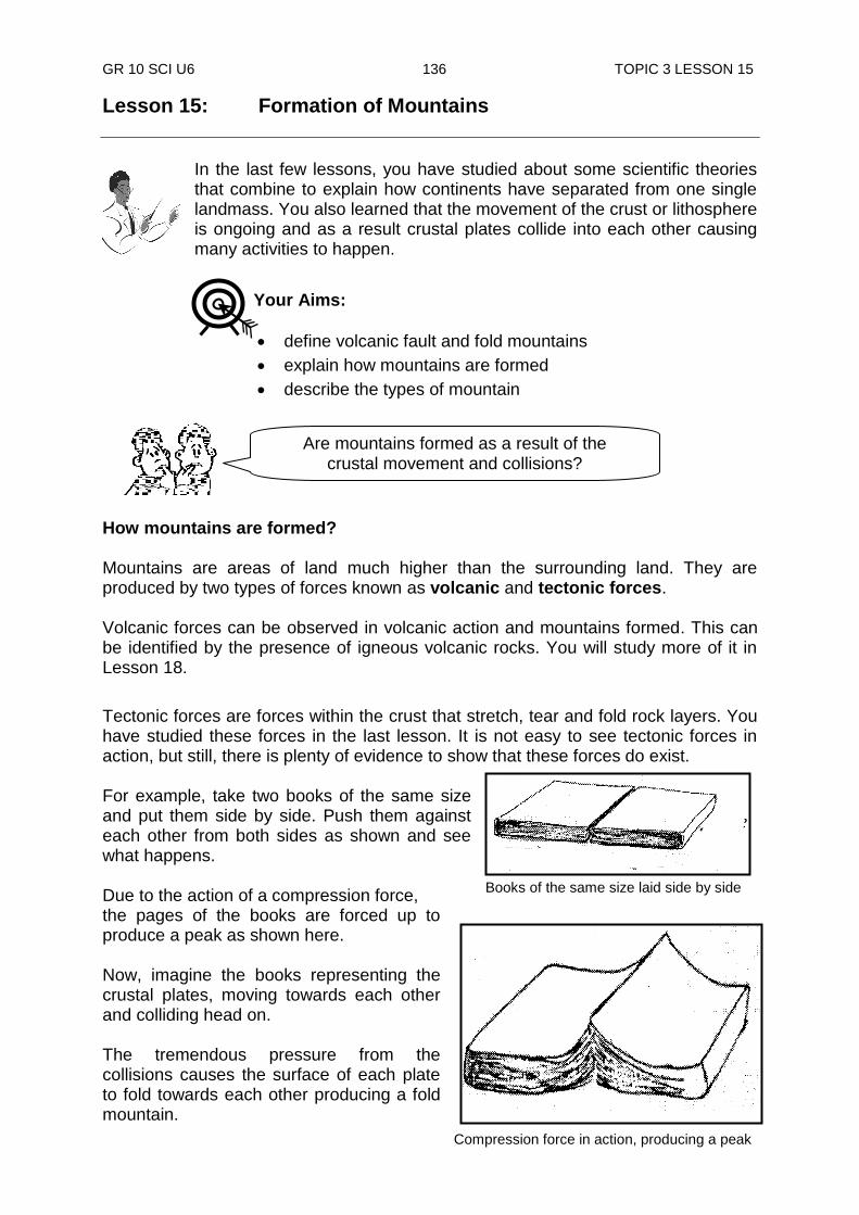
GR 10 SCI U6 136 TOPIC 3 LESSON 15
Compression force in action, producing a peak
Books of the same size laid side by side
Lesson 15: Formation of Mountains
In the last few lessons, you have studied about some scientific theories that combine to explain how continents have separated from one single landmass. You also learned that the movement of the crust or lithosphere is ongoing and as a result crustal plates collide into each other causing many activities to happen.
How mountains are formed? Mountains are areas of land much higher than the surrounding land. They are produced by two types of forces known as volcanic and tectonic forces. Volcanic forces can be observed in volcanic action and mountains formed. This can be identified by the presence of igneous volcanic rocks. You will study more of it in Lesson 18.
Tectonic forces are forces within the crust that stretch, tear and fold rock layers. You have studied these forces in the last lesson. It is not easy to see tectonic forces in action, but still, there is plenty of evidence to show that these forces do exist. For example, take two books of the same size and put them side by side. Push them against each other from both sides as shown and see what happens. Due to the action of a compression force, the pages of the books are forced up to produce a peak as shown here. Now, imagine the books representing the crustal plates, moving towards each other and colliding head on. The tremendous pressure from the collisions causes the surface of each plate to fold towards each other producing a fold mountain.
Are mountains formed as a result of the crustal movement and collisions?
Your Aims:
define volcanic fault and fold mountains
explain how mountains are formed
describe the types of mountain
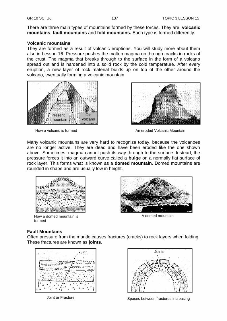
GR 10 SCI U6 137 TOPIC 3 LESSON 15
There are three main types of mountains formed by these forces. They are; volcanic mountains, fault mountains and fold mountains. Each type is formed differently. Volcanic mountains They are formed as a result of volcanic eruptions. You will study more about them also in Lesson 16. Pressure pushes the molten magma up through cracks in rocks of the crust. The magma that breaks through to the surface in the form of a volcano spread out and is hardened into a solid rock by the cold temperature. After every eruption, a new layer of rock material builds up on top of the other around the volcano, eventually forming a volcanic mountain
Many volcanic mountains are very hard to recognize today, because the volcanoes are no longer active. They are dead and have been eroded like the one shown above. Sometimes, magma cannot push its way through to the surface. Instead, the pressure forces it into an outward curve called a bulge on a normally flat surface of rock layer. This forms what is known as a domed mountain. Domed mountains are rounded in shape and are usually low in height.
Fault Mountains Often pressure from the mantle causes fractures (cracks) to rock layers when folding. These fractures are known as joints.
How a volcano is formed An eroded Volcanic Mountain
How a domed mountain is formed
A domed mountain
Present mountain
Old volcano
Joints
Spaces between fractures increasing Joint or Fracture
Joints

GR 10 SCI U6 138 TOPIC 3 LESSON 15
A continuous build-up of pressure under the crust along the fracture causes rock layers to open up, or move one side of the fracture up and the other side down or causes them to slide-pass each other. When this happens, the displaced fracture is known as a fault. You have learned the forces that produce these faults in Lesson 16. The following are some of the common faults produced by these processes. When one side of a fractured rock wall hanging over a fault moves down, a normal fault is formed.When one side of a fractured rock wall hanging over a fault moves up, a reverse fault is formed as shown below.
Normal and reverse faults are produced vertically (upwards or downwards), however, faults can also be formed horizontally. These are known as lateral faults, as shown here. An Example of this is the San Andreas Fault in North America. It is the up and downward faults on a larger scale that produces Fault Mountains. sometimes called Block Mountains.
Lateral Fault
Fault or block mountain
Reverse Fault
Normal Fault
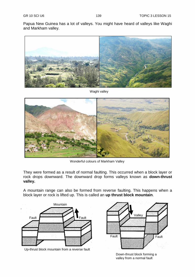
GR 10 SCI U6 139 TOPIC 3 LESSON 15
Fault Fault
Mountain
Up-thrust block mountain from a reverse fault
Fault Fault
Valley
Down-thrust block forming a valley from a normal fault
Waghi valley
Papua New Guinea has a lot of valleys. You might have heard of valleys like Waghi and Markham valley.
They were formed as a result of normal faulting. This occurred when a block layer or rock drops downward. The downward drop forms valleys known as down-thrust valley. A mountain range can also be formed from reverse faulting. This happens when a block layer or rock is lifted up. This is called an up thrust block mountain.
Wonderful colours of Markham Valley

GR 10 SCI U6 140 TOPIC 3 LESSON 15
Laigaip River in Enga
Ramu River in Madang
Panoramio view of
MarkhamRiver in Morobe
Most rivers in Papua New Guinea, like the Ramu River in Madang, Markham River in Morobe and the Lagaip River in Enga province follow fairly closely the line of weakness markings of these faults. Fold Mountains Most common types of mountains are fold mountains. Fold mountains are formed by pressures deep below the lithosphere. When a compression force is applied to some rocks from opposite sides of a crustal plate, they bend. Mainly, sedimentary rocks bend easily in this way. The bending of rocks without breaking is called folding.
As you can see in the diagram below, some layers are up-folded; some are down-folded, while others can be a mixture of complicated folds. The up-folds are called anticlines while the down-folds are called synclines. The other complex folds are known as over-folds.
Earth forces Earth forces
Anticline
Anticline
Syncline
Fold mountains
Compression force bending rock layers without breaking forming fold mountains
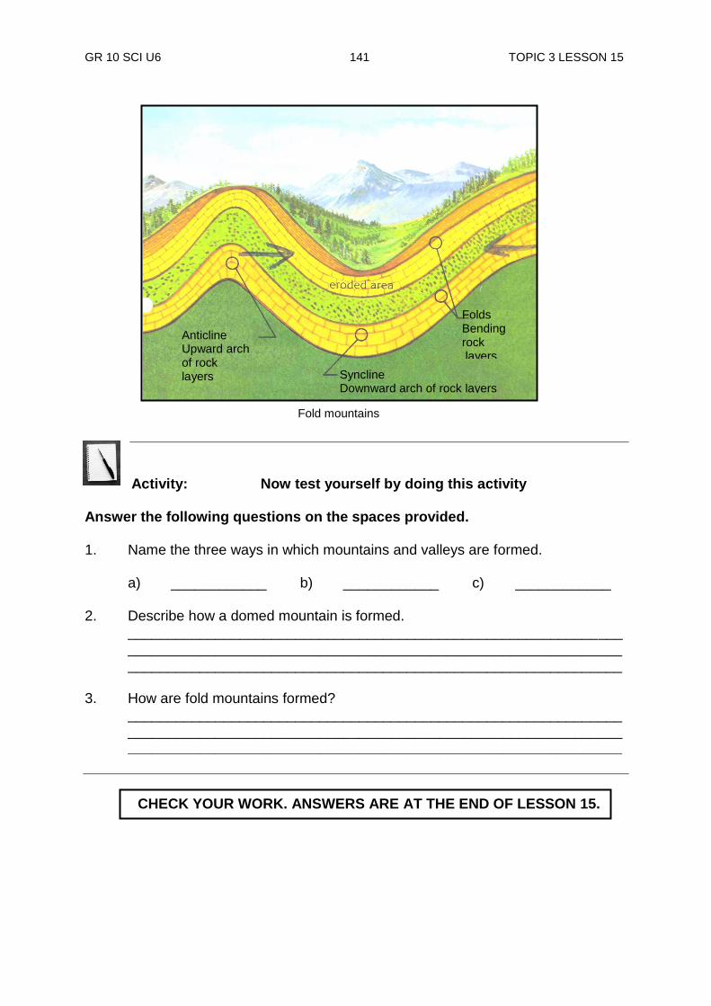
GR 10 SCI U6 141 TOPIC 3 LESSON 15
Activity: Now test yourself by doing this activity
Answer the following questions on the spaces provided. 1. Name the three ways in which mountains and valleys are formed. a) ____________ b) ____________ c) ____________ 2. Describe how a domed mountain is formed.
____________________________________________________________________________________________________________________________
______________________________________________________________ 3. How are fold mountains formed?
____________________________________________________________________________________________________________________________
______________________________________________________________
Anticline Upward arch of rock layers Syncline
Downward arch of rock layers
Folds Bending rock layers
Fold mountains
CHECK YOUR WORK. ANSWERS ARE AT THE END OF LESSON 15.

GR 10 SCI U6 142 TOPIC 3 LESSON 15
Importance of folds
Folds are very important as they are the main source of oil and gas. Therefore, oil explorers search for folded sedimentary rock mountains. In particular, they look for special anticlines where gas and oil could be trapped. Most of the major mountain systems in the world are of fold mountains. The Himalayas were formed in this way due to the „collision‟ of India and Asia. The European Alps were forced up by the „collision‟ of Africa and Europe. The main mountain backbone of Papua New Guinea has been formed in this way as shown on the diagram below, by massive folding of thick sediments. This has been the result of the Australian and Pacific plates colliding some 14 million years ago. And as a result, we have a massive store-up of gas and oil which are now being developed in Southern Highlands and more recently in the Gulf Province.
Impermeable rock
oil
water saturated rock
gas
Main mountain backbone of Papua New Guinea ( Owen Stanley Range )
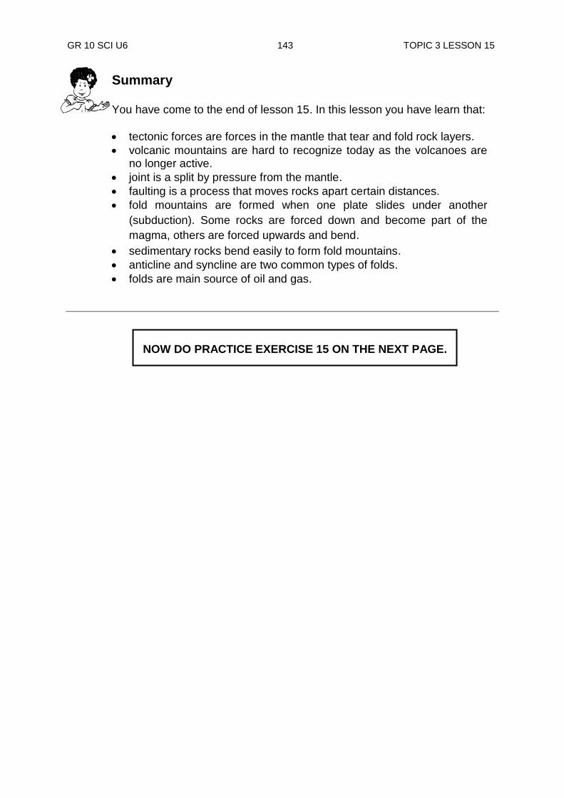
GR 10 SCI U6 143 TOPIC 3 LESSON 15
NOW DO PRACTICE EXERCISE 15 ON THE NEXT PAGE.
Summary You have come to the end of lesson 15. In this lesson you have learn that:
tectonic forces are forces in the mantle that tear and fold rock layers.
volcanic mountains are hard to recognize today as the volcanoes are no longer active.
joint is a split by pressure from the mantle.
faulting is a process that moves rocks apart certain distances.
fold mountains are formed when one plate slides under another
(subduction). Some rocks are forced down and become part of the
magma, others are forced upwards and bend.
sedimentary rocks bend easily to form fold mountains.
anticline and syncline are two common types of folds.
folds are main source of oil and gas.

GR 10 SCI U6 144 TOPIC 3 LESSON 15
Practice Exercise 15
1. List the three types of mountains formed by the forces on Earth. i) ____________________ii)___________________iii) __________________ 2. Why are many mountains hard to be recognized today? ______________________________________________________________ 3. Name the volcanic mountain formed from magma underground. ______________________________________________________________ 4. What is another name for the fractures caused to rock layers by folding? ______________________________________________________________ 5. What is another name for fault mountains? ______________________________________________________________ 6. Name the fault that produces a mountain range. ______________________________________________________________ 7. Name the faults that produce a mountain range. ______________________________________________________________ 8. Why are folds mountains so important? ______________________________________________________________ ______________________________________________________________ 9. Define the following terms. i) Folding
__________________________________________________________________________________________________________________
ii) Anticline __________________________________________________________________________________________________________________
iii) Over-folds __________________________________________________________________________________________________________________
iv) Syncline ______________________________________________________________
CHECK YOUR ANSWERS AT THE END OF TOPIC 3
GR 10 SCI U6 145 TOPIC 3 LESSON 15
Answers to Activity 1. a) by folding b) by faulting c) by volcanoes 2. Domed mountains are formed when magma cannot push its way through to
the surface. Instead, the pressure forces it into an outward curve called a bulge on a normally flat surface of rock layer.
3. Fold mountains are formed when one plate slides under another (subduction).
Some rocks are forced down and become part of the magma, others are forced upwards and bend.
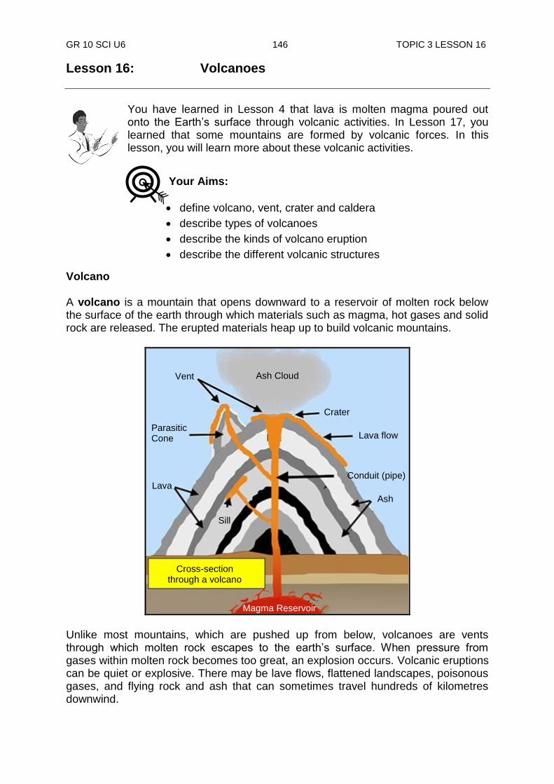
GR 10 SCI U6 146 TOPIC 3 LESSON 16
Lesson 16: Volcanoes
You have learned in Lesson 4 that lava is molten magma poured out onto the Earth‟s surface through volcanic activities. In Lesson 17, you learned that some mountains are formed by volcanic forces. In this lesson, you will learn more about these volcanic activities.
Volcano A volcano is a mountain that opens downward to a reservoir of molten rock below the surface of the earth through which materials such as magma, hot gases and solid rock are released. The erupted materials heap up to build volcanic mountains.
Unlike most mountains, which are pushed up from below, volcanoes are vents through which molten rock escapes to the earth‟s surface. When pressure from gases within molten rock becomes too great, an explosion occurs. Volcanic eruptions can be quiet or explosive. There may be lave flows, flattened landscapes, poisonous gases, and flying rock and ash that can sometimes travel hundreds of kilometres downwind.
Your Aims:
define volcano, vent, crater and caldera
describe types of volcanoes
describe the kinds of volcano eruption
describe the different volcanic structures
Ash Cloud Vent
Crater
Lava flow
Conduit (pipe)
Ash
Parasitic Cone
Lava
Sill
Cross-section through a volcano
Magma Reservoir
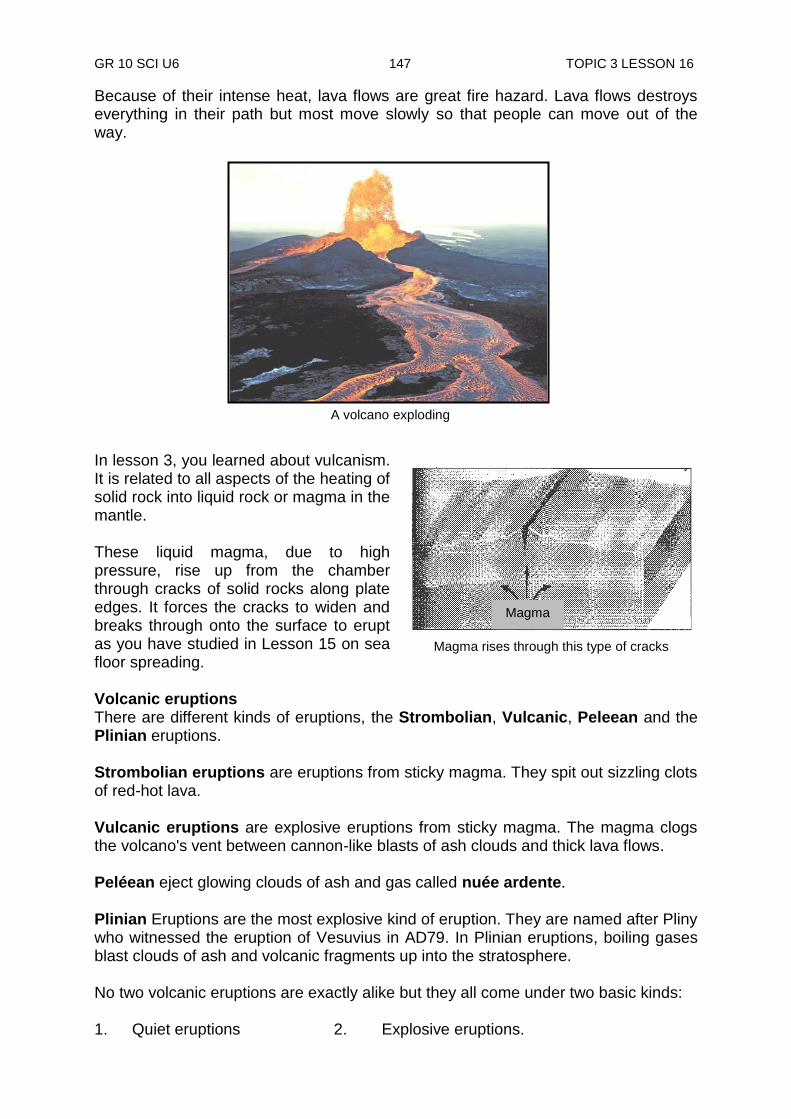
GR 10 SCI U6 147 TOPIC 3 LESSON 16
Magma rises through this type of cracks
Because of their intense heat, lava flows are great fire hazard. Lava flows destroys everything in their path but most move slowly so that people can move out of the way.
In lesson 3, you learned about vulcanism. It is related to all aspects of the heating of solid rock into liquid rock or magma in the mantle. These liquid magma, due to high pressure, rise up from the chamber through cracks of solid rocks along plate edges. It forces the cracks to widen and breaks through onto the surface to erupt as you have studied in Lesson 15 on sea floor spreading. Volcanic eruptions There are different kinds of eruptions, the Strombolian, Vulcanic, Peleean and the Plinian eruptions. Strombolian eruptions are eruptions from sticky magma. They spit out sizzling clots of red-hot lava. Vulcanic eruptions are explosive eruptions from sticky magma. The magma clogs the volcano's vent between cannon-like blasts of ash clouds and thick lava flows. Peléean eject glowing clouds of ash and gas called nuée ardente.
Plinian Eruptions are the most explosive kind of eruption. They are named after Pliny who witnessed the eruption of Vesuvius in AD79. In Plinian eruptions, boiling gases blast clouds of ash and volcanic fragments up into the stratosphere. No two volcanic eruptions are exactly alike but they all come under two basic kinds: 1. Quiet eruptions 2. Explosive eruptions.
A volcano exploding
Magma
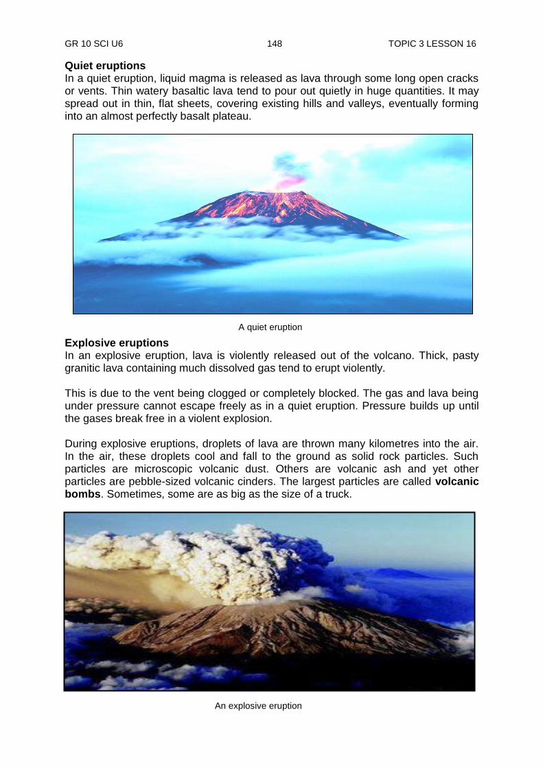
GR 10 SCI U6 148 TOPIC 3 LESSON 16
A quiet eruption
Quiet eruptions In a quiet eruption, liquid magma is released as lava through some long open cracks or vents. Thin watery basaltic lava tend to pour out quietly in huge quantities. It may spread out in thin, flat sheets, covering existing hills and valleys, eventually forming into an almost perfectly basalt plateau. Explosive eruptions In an explosive eruption, lava is violently released out of the volcano. Thick, pasty granitic lava containing much dissolved gas tend to erupt violently. This is due to the vent being clogged or completely blocked. The gas and lava being under pressure cannot escape freely as in a quiet eruption. Pressure builds up until the gases break free in a violent explosion. During explosive eruptions, droplets of lava are thrown many kilometres into the air. In the air, these droplets cool and fall to the ground as solid rock particles. Such particles are microscopic volcanic dust. Others are volcanic ash and yet other particles are pebble-sized volcanic cinders. The largest particles are called volcanic bombs. Sometimes, some are as big as the size of a truck.
An explosive eruption

GR 10 SCI U6 149 TOPIC 3 LESSON 16
Vent, crater and caldera During an eruption, lava and other materials spread out from the vent (central opening of a volcano). Much of the materials pile up around the vent forming a cone-shaped volcanic mountain. As more eruptions occur, more materials add to the height and even widening the mound. A cup-like depression called a crater surrounds the vent at the top of a volcano. A large crater is usually formed by the collapse of a volcano called a caldera. The whole of Rabaul is a caldera. It was formed when the top of a large volcano was blown away many thousands of years ago. Volcanic structures Volcanoes have different structures. Some types of volcanoes are easily recognisable and while others are not. Geologists classify volcanic structures by their shape and composition. Shape of a volcano is determined by the type of eruption and the materials released. Most people have never seen a real volcano but learned about them through movies or books. So when most people think of a volcano, they picture a huge, menacing conical mountain that explodes and spews out masses of lava which falls on rampaging animals, screaming people, or fleeing mobs of humans, depending on
their favourite volcano disaster movie. Composite volcano As stated earlier, some types of volcanoes are easily recognisable and while others are not. The types that we all know about are easily recognised. These volcanoes are typically some kilometres across and almost ten thousand kilometres in height. As illustrated in the diagram on the right, they have moderately steep sides and sometimes have small craters in their summits. Volcanologists call these strato or composite volcanoes because they consist of layers of solid lava flows mixed with layers of sand, or gravel-like volcanic rock called cinders or volcanic ash.
Composite volcano
Lava Flows
Cinders
Caldera

GR 10 SCI U6 150 TOPIC 3 LESSON 16
Cinders
A small, steep-sided, cone-shaped volcano made of volcanic cinders and other rock particles is called cinder cone.
A composite volcano has a very large symmetrical cone of alternating layers of solidified lava and rock particles. They are formed by alternating periods of quiet eruptions of thick lava followed by explosive eruptions of thick lava. Most of the world‟s largest active volcanoes are of this type. Many are located in populated areas and have well-known names: Vesuvius, Krakatoa, Fujiyama in Japan, Pintubo in the Philippines and Mount St. Helens in Washington State are some examples. Cinder cone volcano Another easily recognized type of volcano, as seen in the diagram on the right is the cinder cone. As you might expect from the name, these volcanoes consist almost entirely of loose, grainy cinders and almost no lava. They are small volcanoes, usually only about two kilometres across and on average 1600km high. They have very steep sides and usually have a small crater on top. Cinder cones are formed by explosive eruptions
Mt.Pinatubo in Philippines Mt. Fujiyama in Japan
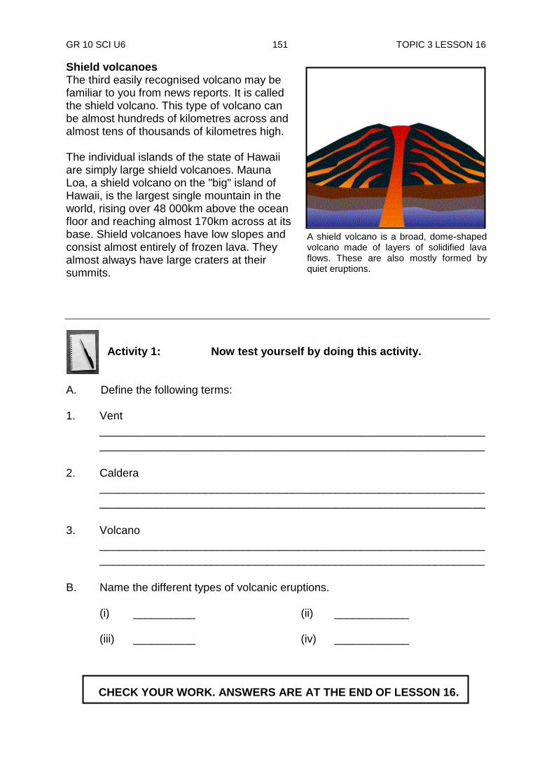
GR 10 SCI U6 151 TOPIC 3 LESSON 16
Shield volcanoes The third easily recognised volcano may be familiar to you from news reports. It is called the shield volcano. This type of volcano can be almost hundreds of kilometres across and almost tens of thousands of kilometres high. The individual islands of the state of Hawaii are simply large shield volcanoes. Mauna Loa, a shield volcano on the "big" island of Hawaii, is the largest single mountain in the world, rising over 48 000km above the ocean floor and reaching almost 170km across at its base. Shield volcanoes have low slopes and consist almost entirely of frozen lava. They almost always have large craters at their summits.
Activity 1: Now test yourself by doing this activity.
A. Define the following terms: 1. Vent
______________________________________________________________
______________________________________________________________
2. Caldera
______________________________________________________________
______________________________________________________________
3. Volcano
______________________________________________________________
______________________________________________________________
B. Name the different types of volcanic eruptions.
(i) __________ (ii) ____________
(iii) __________ (iv) ____________
A shield volcano is a broad, dome-shaped volcano made of layers of solidified lava flows. These are also mostly formed by quiet eruptions.
CHECK YOUR WORK. ANSWERS ARE AT THE END OF LESSON 16.

GR 10 SCI U6 152 TOPIC 3 LESSON 16
Past and present volcanoes Thousands of volcanoes are spread all over the world. Some are active, some are dormant and still others are extinct. Active volcanoes Volcanoes that are erupting now or have erupted in the recent past are known as active. You can see on the world distribution of volcanoes on the map at the right, most of the world‟s active volcanoes are located in the Pacific Ring of Fire and PNG (encircled) is included in these active volcanic zones. You will learn more of volcanic activities of PNG in Lesson 20. On the island of Hawaii, the Mauna Loa volcano, which erupted in 1935, is active. The U.S Army Corps bombed the volcano and successfully diverted the lava flow towards unpopulated areas. Dormant volcanoes A volcano which erupted long time ago, resting now but might erupt again sometimes later is known as a dormant volcano. Mt Lamington in Oro Province erupted in 1951, killing more than three thousand people and injuring many, the worst natural disaster in PNG history, falls into this group. It is quiet now and people are living again in the area. The area has now been developed into coffee and oil-palm plantations. Extinct volcanoes Volcanoes which are completely inactive and no longer erupt are said to be extinct. Mt. Hagen and Mt. Giluwe are two remains of extinct volcanoes. Effects of volcanoes Volcanoes can be dangerous. They can cause a lot of damage to life and property. Most of the volcanic activity is concentrated along the edges of plate boundaries. These are the spots where a lot of crustal weakness magma can easily find its way to release its pressure. Volcanoes produce dangerous gases like sulphur dioxide and nitrogen dioxide which are released into the atmosphere. They combined with water vapour in the air to produce acid rain. This further affects plants and animals. The salts produced from the volcano make the soil very fertile to grow crops.
Ring of fire

GR 10 SCI U6 153 TOPIC 3 LESSON 16
Summary You have come to the end of lesson 16. In this lesson you have learnt that:
volcano is an opening in the earth‟s crust through which materials such as magma, hot gases and solid rock are released.
a cup-like depression called a crater surrounds the vent at the top of a volcano. A large crater is usually formed by the collapse of a volcano called a caldera.
the vent is the central opening of a volcano.
a shield volcano is a broad, dome-shaped volcano made of layers of solidified lava flows that are mostly formed by quiet eruptions.
a small, steep-sided, cone-shaped volcano made of volcanic cinders and other rock particles is called the cinder cone formed by explosive formed by explosive eruptions.
a composite volcano is a very large symmetrical cone of alternating layers of solidified lava and rock particles. They are formed by alternating periods of quiet and explosive eruptions.
in active volcano eruptions can be any time and often.
dormant volcano has been quiet for a while since it has erupted, but could erupt at any time.
extinct volcano means it has not erupted in a very long, long time so it will never erupt again.
NOW DO PRACTICE EXERCISE 16 ON THE NEXT PAGE.
GR 10 SCI U6 154 TOPIC 3 LESSON 16
Practice Exercise 16
Answer the following questions. 1. Name the two basic kinds of volcanic eruptions.
i) __________ ii) __________ 2. Name the central opening of a volcano ______________________________________________________________ 3. Name the large cup-like depression caused by the collapse of a volcano ______________________________________________________________ 4. How are volcanic structures classified? ______________________________________________________________ 5. List three volcanic structures you have learned.
i) __________ ii) __________ ii) __________ 6. Define the following terms;
i) volcano: _________________________________________________________
ii) quiet eruption : ________________________________________________________
iii) volcanic bomb _________________________________________________________
iv) active volcano _________________________________________________________
v) dormant volcano _________________________________________________________
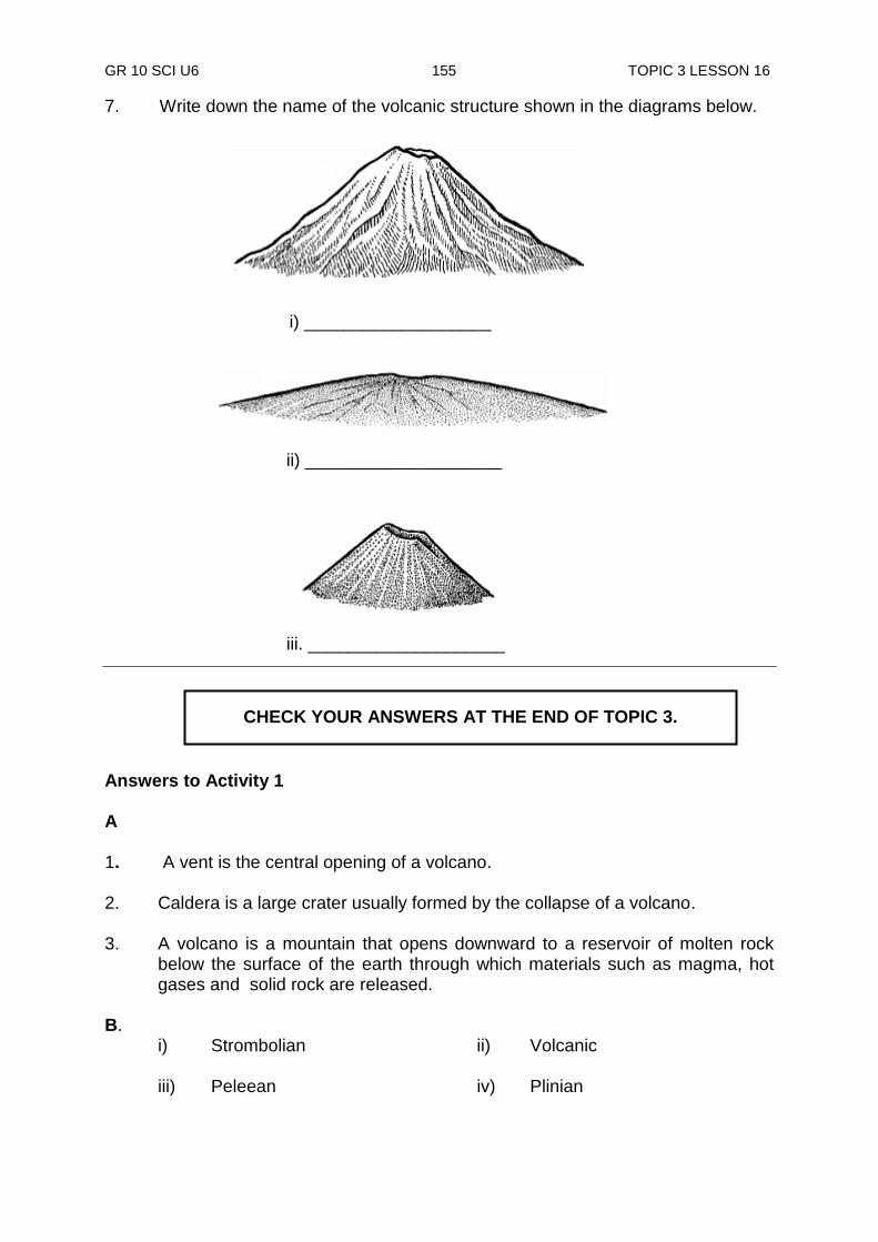
GR 10 SCI U6 155 TOPIC 3 LESSON 16
7. Write down the name of the volcanic structure shown in the diagrams below.
Answers to Activity 1 A 1. A vent is the central opening of a volcano. 2. Caldera is a large crater usually formed by the collapse of a volcano. 3. A volcano is a mountain that opens downward to a reservoir of molten rock
below the surface of the earth through which materials such as magma, hot gases and solid rock are released.
B. i) Strombolian ii) Volcanic
iii) Peleean iv) Plinian
i) ___________________
ii) ____________________
iii. ____________________
CHECK YOUR ANSWERS AT THE END OF TOPIC 3.
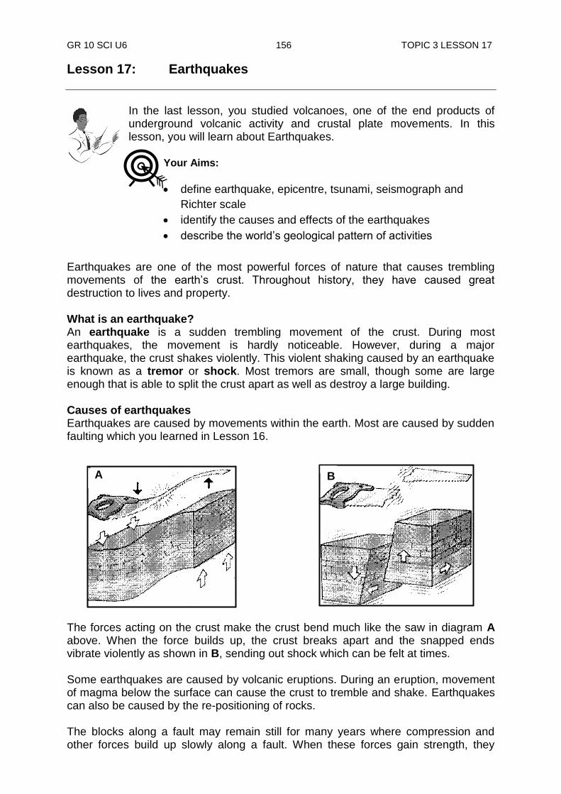
GR 10 SCI U6 156 TOPIC 3 LESSON 17
Lesson 17: Earthquakes
In the last lesson, you studied volcanoes, one of the end products of underground volcanic activity and crustal plate movements. In this lesson, you will learn about Earthquakes.
Earthquakes are one of the most powerful forces of nature that causes trembling movements of the earth‟s crust. Throughout history, they have caused great destruction to lives and property. What is an earthquake? An earthquake is a sudden trembling movement of the crust. During most earthquakes, the movement is hardly noticeable. However, during a major earthquake, the crust shakes violently. This violent shaking caused by an earthquake is known as a tremor or shock. Most tremors are small, though some are large enough that is able to split the crust apart as well as destroy a large building. Causes of earthquakes Earthquakes are caused by movements within the earth. Most are caused by sudden faulting which you learned in Lesson 16.
The forces acting on the crust make the crust bend much like the saw in diagram A above. When the force builds up, the crust breaks apart and the snapped ends vibrate violently as shown in B, sending out shock which can be felt at times. Some earthquakes are caused by volcanic eruptions. During an eruption, movement of magma below the surface can cause the crust to tremble and shake. Earthquakes can also be caused by the re-positioning of rocks. The blocks along a fault may remain still for many years where compression and other forces build up slowly along a fault. When these forces gain strength, they
Your Aims:
define earthquake, epicentre, tsunami, seismograph and
Richter scale
identify the causes and effects of the earthquakes
describe the world‟s geological pattern of activities
A
B
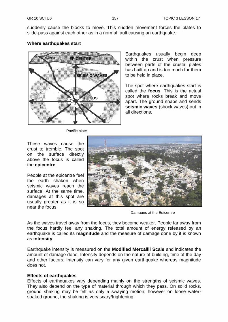
GR 10 SCI U6 157 TOPIC 3 LESSON 17
Damages at the Epicentre
suddenly cause the blocks to move. This sudden movement forces the plates to slide-pass against each other as in a normal fault causing an earthquake. Where earthquakes start
Earthquakes usually begin deep within the crust when pressure between parts of the crustal plates has built up and is too much for them to be held in place. The spot where earthquakes start is called the focus. This is the actual spot where rocks break and move apart. The ground snaps and sends seismic waves (shock waves) out in all directions.
These waves cause the crust to tremble. The spot on the surface directly above the focus is called the epicentre. People at the epicentre feel the earth shaken when seismic waves reach the surface. At the same time, damages at this spot are usually greater as it is so near the focus. As the waves travel away from the focus, they become weaker. People far away from the focus hardly feel any shaking. The total amount of energy released by an earthquake is called its magnitude and the measure of damage done by it is known as intensity. Earthquake intensity is measured on the Modified Mercallli Scale and indicates the amount of damage done. Intensity depends on the nature of building, time of the day and other factors. Intensity can vary for any given earthquake whereas magnitude does not. Effects of earthquakes Effects of earthquakes vary depending mainly on the strengths of seismic waves. They also depend on the type of material through which they pass. On solid rocks, ground shaking may be felt as only a swaying motion, however on loose water-soaked ground, the shaking is very scary/frightening!
FOCUS
SEISMIC WAVES
EPICENTRE NAZCA
PLATEFAULT
Pacific plate
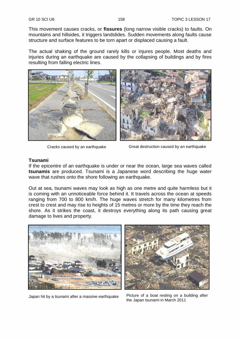
GR 10 SCI U6 158 TOPIC 3 LESSON 17
Picture of a boat resting on a building after the Japan tsunami in March 2011
This movement causes cracks, or fissures (long narrow visible cracks) to faults. On mountains and hillsides, it triggers landslides. Sudden movements along faults cause structure and surface features to be torn apart or displaced causing a fault. The actual shaking of the ground rarely kills or injures people. Most deaths and injuries during an earthquake are caused by the collapsing of buildings and by fires resulting from falling electric lines.
Tsunami If the epicentre of an earthquake is under or near the ocean, large sea waves called tsunamis are produced. Tsunami is a Japanese word describing the huge water wave that rushes onto the shore following an earthquake. Out at sea, tsunami waves may look as high as one metre and quite harmless but it is coming with an unnoticeable force behind it. It travels across the ocean at speeds ranging from 700 to 800 km/h. The huge waves stretch for many kilometres from crest to crest and may rise to heights of 15 metres or more by the time they reach the shore. As it strikes the coast, it destroys everything along its path causing great damage to lives and property.
Japan hit by a tsunami after a massive earthquake
Great destruction caused by an earthquake Cracks caused by an earthquake
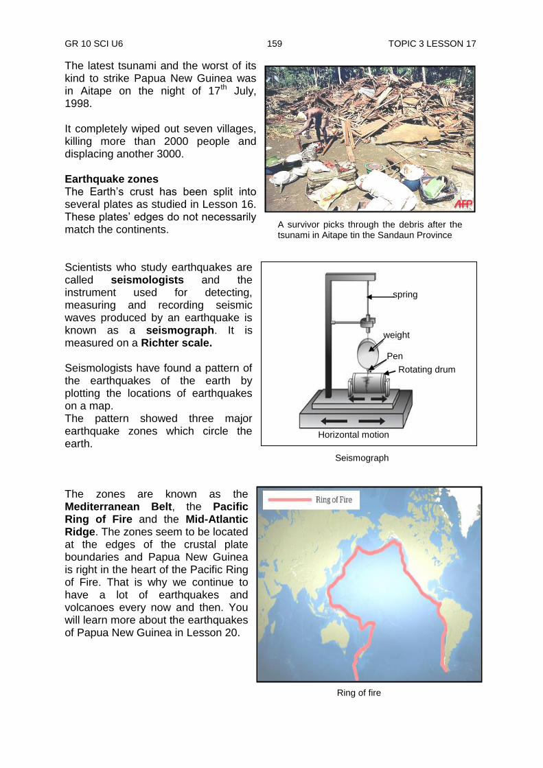
GR 10 SCI U6 159 TOPIC 3 LESSON 17
A survivor picks through the debris after the tsunami in Aitape tin the Sandaun Province
Ring of fire
Seismograph
The latest tsunami and the worst of its kind to strike Papua New Guinea was in Aitape on the night of 17th July, 1998. It completely wiped out seven villages, killing more than 2000 people and displacing another 3000. Earthquake zones The Earth‟s crust has been split into several plates as studied in Lesson 16. These plates‟ edges do not necessarily match the continents. Scientists who study earthquakes are called seismologists and the instrument used for detecting, measuring and recording seismic waves produced by an earthquake is known as a seismograph. It is measured on a Richter scale. Seismologists have found a pattern of the earthquakes of the earth by plotting the locations of earthquakes on a map. The pattern showed three major earthquake zones which circle the earth. The zones are known as the Mediterranean Belt, the Pacific Ring of Fire and the Mid-Atlantic Ridge. The zones seem to be located at the edges of the crustal plate boundaries and Papua New Guinea is right in the heart of the Pacific Ring of Fire. That is why we continue to have a lot of earthquakes and volcanoes every now and then. You will learn more about the earthquakes of Papua New Guinea in Lesson 20.
spring
weight
Pen
Rotating drum
Horizontal motion
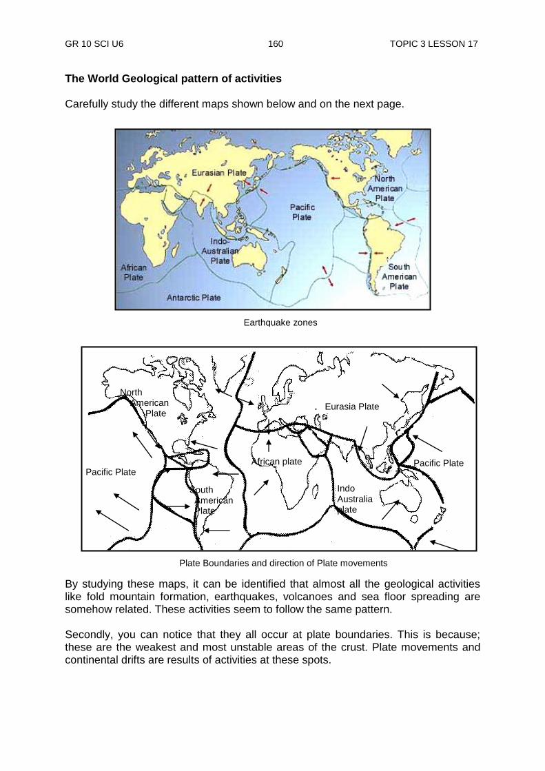
GR 10 SCI U6 160 TOPIC 3 LESSON 17
Earthquake zones
The World Geological pattern of activities Carefully study the different maps shown below and on the next page.
By studying these maps, it can be identified that almost all the geological activities like fold mountain formation, earthquakes, volcanoes and sea floor spreading are somehow related. These activities seem to follow the same pattern. Secondly, you can notice that they all occur at plate boundaries. This is because; these are the weakest and most unstable areas of the crust. Plate movements and continental drifts are results of activities at these spots.
Pacific Plate African plate
North American Plate
South American Plate
Pacific Plate
Eurasia Plate
Indo Australia plate
Plate Boundaries and direction of Plate movements
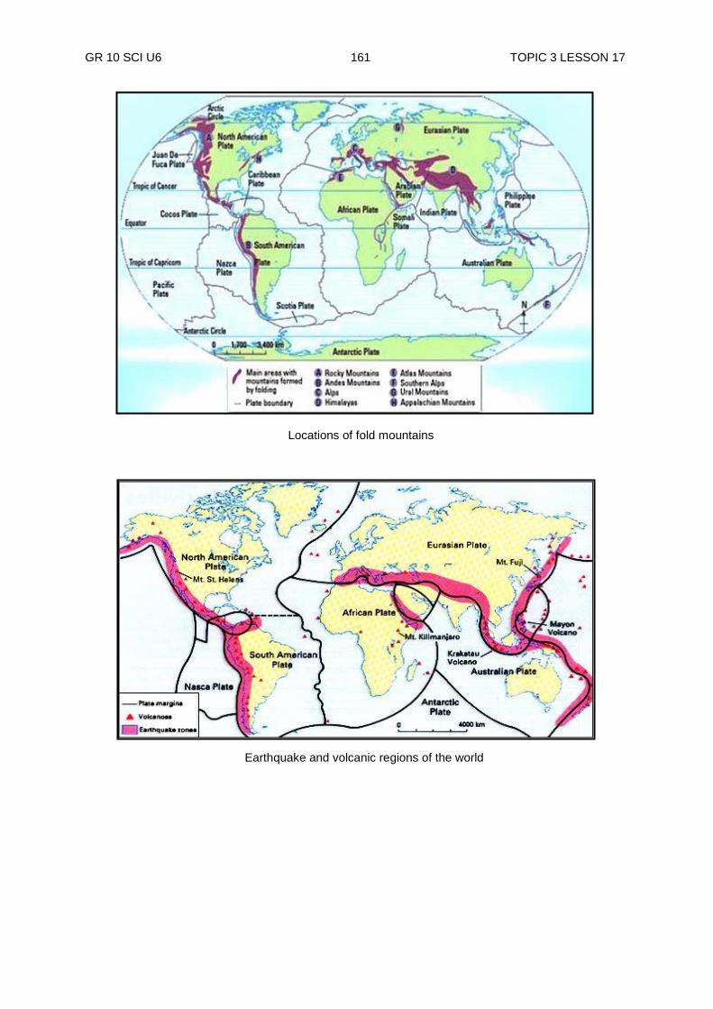
GR 10 SCI U6 161 TOPIC 3 LESSON 17
Locations of fold mountains
Earthquake and volcanic regions of the world

GR 10 SCI U6 162 TOPIC 3 LESSON 17
NOW DO PRACTICE EXERCISE 17 ON THE NEXT PAGE.
Summary You have come to the end of lesson 17. In this lesson you have learnt that:
an earthquake is a sudden trembling movement of the crust.
earthquakes can be caused by volcanic eruptions, landslides and re-positioning of rocks.
“seismic waves” are waves of vibrations caused by an earthquake
“focus” is the spot where an earthquake starts and “epicentre” is the spot on the surface of the focal point.
during an earthquake, major damage can be done at the epicentre.
intensity is the amount of damage done by an earthquake.
the total amount of energy released by an earthquake is called its magnitude.
if the epicentre is under or close to t sea, large sea waves called tsunamis are produced.
the latest and the worst tsunami to strike PNG was in Aitape on the night of 17th July 1998, where it killed more than 2000 people.
GR 10 SCI U6 163 TOPIC 3 LESSON 17
Practice Exercise 17
1. Define the following terms:
i) seismograph
_________________________________________________________
ii) tsunamis
_________________________________________________________
ii) fissures _________________________________________________________
iv) magnitude _________________________________________________________
v) epicentre
_________________________________________________________
vi) seismic waves _________________________________________________________
vii) focus _________________________________________________________
vii) tremor _________________________________________________________
2. What is an earthquake? ______________________________________________________________ 3. List two things that triggers (causes) earthquakes.
i) ______________________________________ ii) ______________________________________
4. What happens as the earthquake waves travel away from the epicentre? ______________________________________________________________ ______________________________________________________________ 5. What is the name given to the amount of damage done by an earthquake? ______________________________________________________________ 6. The actual shaking of the ground rarely kills or injures people. If that is the
case, then, what causes most of the deaths and damages we hear and read from the media?
______________________________________________________________ ______________________________________________________________
GR 10 SCI U6 164 TOPIC 3 LESSON 17
7. List two other effects caused by earthquakes. i) ___________________________ ii) ____________________________ 8. What do we call the scientists who study earthquakes? ____________________________________________ 9. List the three world earthquake zones.
i) ____________________________________ ii) ____________________________________ iii) ____________________________________
10. Give a reason as to why earthquakes, fold mountains and volcanic activities
seem to happen along the same zones. ______________________________________________________________ ______________________________________________________________
CHECK YOUR WORK. ANSWERS ARE AT THE END OF TOPIC 3.
GR 10 SCI U6 165 ANSWERS TO PRACTICE EXERCISES
Answers to Practice Exercises 12 - 17 Practice Exercise 12 1. It is a belief. It is a carefully built out set of ideas that explain things we see
happening or thought to have happened in the past. 2. Science progresses when an existing theory is replaced by another that
explains better than the present evidence. 3. When there are some loop holes in a theory and that cannot be fully
explained. 4. The continents are lighter than sea floors,that is why they float on top of the
sea floors. 5. The continents rise up. 6. i) it cannot explain the presence of volcanic islands on the sea floor ii) it cannot explain horizontal movements of the crust
iii) it cannot explain the formation of new land and mountains under the sea
7. The huge landmass got split apart into continents and have drifted apart to
their present positions. 8. They found it hard to believe that a huge landmass could hardly move across
the earth‟s surface 9. i) The continents that seem to have touched one time had similar rock
types and rock distribution patterns.. ii) If the continents were ever brought together, they would match exactly. iii) Coal was formed in warm climates but it is found in cold climates (any three)
iv) Glacier deposits are supposed to be found in cold climates but are found in warm climates.
10. The theory does not explain what had caused the continents to drift apart.
Practice Exercise 13 1. i) mid-ocean ridges: Long underwater mountain ranges ii) sea mounts: underwear mountains along the basins
GR 10 SCI U6 166 ANSWERS TO PRACTICE EXERCISES
iii) trenches: part of the sea floor descending in deep channels 2. It states that great heat and pressure at the mantle forces rift valleys to open
up, allowing hot magma to swell out forming new materials at the sea floors. 3. That ridges are pushed up by rising magma from beneath the crust 4. There is existence of life near the active volcanic rifts. 5. That life can be supported by the energy from within the earth rather than the sun. 6. That it only explains the features of the sea floor and nothing of the continents.
Practice Exercise 14 1. i) The Plate Tectonic theory ii) It combines and summaries all the theories into one single theory. 2. The point that the crust is made up of several huge moving pieces or plates 3. The lithosphere is split into seven major and five minor plates 4. The unifying theory says that these plates are always in motion (moving) 5. i) compression force ii) shear force iii) tension force 6. Compression force 7. Australian and the Pacific plates
Practice Exercise 15 1. i) fold mountains ii) fault mountains iii) volcanic mountains 2. Because the volcanoes are extinct and have been eroded away 3. Dome mountain 4. Joint 5. Block mountains 6. Normal faulting 7. Reverse faulting
GR 10 SCI U6 167 ANSWERS TO PRACTICE EXERCISES
8. They are main source of oil and gas 9. i) folding: The bending of rocks without breaking ii) Anticline: the up-folding of rocks iii) Over-folds: mixture of complicated folds iv) Syncline: the up-folding of rocks
Practice Exercise 16 1. i) quite eruptions ii) Explosive eruptions 2. Vent 3. Caldera 4. by their shape and their composition 5. i) Cinder cones ii) Shield volcanoes iii) Composite volcanoes 6. i) Volcano is an opening in the earth‟s crust through which materials such
as magma, hot gases and solid rock are erupted ii) Quite eruptions Liquid magma tend to pour out quietly in huge quantities through some
long open cracks or vents iii) Volcanic bomb is the largest pebble-sized particles of volcanic cinders. iv) Active volcano is erupting now or have erupted in the recent past.
iv) Dormant volcano: a volcano which erupted long time ago, resting now but might erupt again sometimes later.
7. i) Composite volcano ii) Shield volcano ii) Cinder cone volcano
GR 10 SCI U6 168 ANSWERS TO PRACTICE EXERCISES
Practice Exercise 17 1. i) Seismograph: an instrument used for detecting, measuring and
recording seismic waves produced by an earthquake. ii) Tsunamis: large sea waves produced by an earthquake iii) Fissures: long narrow visible cracks iv) Magnitude: the amount of energy released by an earthquake v) Epicenter: the spot on the surface directly above the focus
viii) Focus: is the spot where an earthquake starts and “epicentre” is the spot on the surface of the focal point
viii) Tremor: The violent shaking caused by an earthquake 2. The sudden trembling movement of the crust 3. i) Volcanic eruptions
ii) Re-positioning of rocks 4. They become weaker as they move away from the epicentre. 5. Intensity 6. by the collapsing of building and by fires resulting from falling electric lines. 7. i) the movement causes rocks, or fissures to form ii) it triggers landslides 8. Geologists 9. i) The Mediterranean Belt ii) The Pacific Ring of fire iii) The Mid-Atlantic Ridge 10. Because, these are the weakest and most unstable areas of the crust.
REVISE TOPIC 3 USING THE MAIN POINTS ON THE NEXT PAGE.
GR 10 SCI U6 169 TOPIC 3 REVIEW
REVIEW OF TOPIC 3: Geological Activities
Now, revise all lessons in this Topic and then do ASSIGNMENT 6. Here are the main points to help you revise. Lesson 12: Isostasy Theory
A theory is a carefully built out set of ideas that try to explain things happening or thought to have happened. For a theory to be accepted, it must be proven by tests supported by evidence.
Science progresses when an existing theory is replaced by another that explains better than the present evidence.
The isostasy theory states that less dense objects float on dense objects.
The less dense crust is floating on the dense mantle
All the continents were once part of a single landmass which got split and separated. This is according to the continental theory.
Lesson 13: Sea-Floor Spreading Theory
The ocean floor is full of mountains and valleys just like we have on land. The sea-floor spreading theory explains how all these features form.
When two plates collide, part of the sea floor is thrashed down under the other and a deep trench is formed.
The ages of rock of the sea floor are much younger than rocks of the continents.
The ages of rock of the sea floor are much get their energy from within the earth rather than the sun
Lesson 14: Plate Tectonic Theory
The crust has seven major and five minor plates which are always in motion magma activity in the mantle causes plates to collide
PNG was formed when the Australian and the Pacific plates collided millions of years ago.
Crustal movements have pushed the continents from where they were some millions of years ago.
Transform-Fault Boundaries are where two plates are sliding horizontally past one another.
Lesson 15: Formation of Mountains
Tectonic forces are forces in the mantle that tear and fold rock layers.
volcanic mountains are hard to recognize today as the volcanoes are no longer active.
A joint is a split by pressure from the mantle
Faulting is a process that moves rocks apart certain distances
Fold Mountains are formed when one plate slides under another (subduction).
Some rocks are forced down and become part of the magma, others are forced
upwards and bend.
Sedimentary rocks bend easily to form fold mountains.
Anticline and syncline are two common types of folds.
Folds are main source of oil and gas explorations.

GR 10 SCI U6 170 TOPIC 3 REVIEW
Lesson 16: Volcanoes
Volcano is an opening in the earth‟s crust through which materials such as magma, hot gases and solid rock are released.
A cup-like depression called a crater surrounds the vent at the top of a volcano. A large crater is usually formed by the collapse of a volcano called a caldera.
The vent is the central opening of a volcano.
A shield volcano is a broad, dome-shaped volcano made of layers of solidified lava flows that are mostly formed by quiet eruptions.
A small, steep-sided, cone-shaped volcano made of volcanic cinders and other rock particles is called cinder cone formed by explosive eruptions.
A composite volcano is a very large symmetrical cone of alternating layers of solidified lava and rock particles. They are formed by alternating periods of quiet and explosive eruptions.
In an active volcano eruptions can be any time and often.
A dormant volcano has been quiet for a while since it has erupted, but could at any time
An extinct volcano has not erupted in a very long, long time so it will never erupt again.
Lesson 17: Earthquakes
An earthquake is a sudden trembling movement of the crust.
Earthquakes can be caused by volcanic eruptions, landslides and re-positioning of rocks.
“Seismic waves” are waves of vibrations caused by an earthquake
“Focus” is the spot where an earthquake starts and “epicentre” is the spot on the surface of the focal point.
During an earthquake, greater damage can be done at the epicentre.
Intensity is the amount of damage done by an earthquake.
The total amount of energy released by an earthquake is called its magnitude
If the epicentre is under or close to the sea, large sea waves called tsunamis are produced.
The latest and the worst tsunami to strike PNG was in Aitape on the night of 17th July 1998, where it killed more than 2000 people.
REVISE WELL AND THEN DO TOPIC TEST 3 IN YOUR ASSIGNMENT 6
GR 10 SCI U6 171 TITLE
TOPIC 4
GEOLOGICAL ACTIVITIES IN PAPUA NEW GUINEA
In this topic you will learn about
geological landscape of PNG
earthquakes in PNG
volcanic eruptions

GR 10 SCI U6 172 TOPIC 4 LESSON 18
INTRODUCTION TO TOPIC 4: GEOLOGICAL ACTIVITIES IN PNG
Papua New Guinea (PNG) situated on the Pacific Ring of fire is facing regular disasters. According to the World Bank‟s Natural Disaster Hotspot study PNG is prone to earthquakes, volcanic eruptions, tsunamis, cyclones, river and coastal flooding, landslides and drought. It is ranked 54th among countries exposed to multiple hazards based on land area. Large parts of the country are extremely isolated. Most parts of the Highlands were not accessed until the 1930s and many settlements are still inaccessible except by very difficult over land routes or by air. The capital city is still not connected by road to most of the country. (Source: Global Logistics ClusterWFP February March 2011).
In this topic, we will study the key physical features of the country, the main risks and hazards faced and the responsibilities you play in responding to various disasters. You ask yourself the following questions as you go through this topic.
What are the geological activities and developments are there in PNG?
Where is the location of PNG in earthquake zone?
What are the types of volcanic eruptions in PNG
Landscape of Papua New Guinea
In this Topic, you will find the answers to these questions and all other questions relating to geological activities in PNG
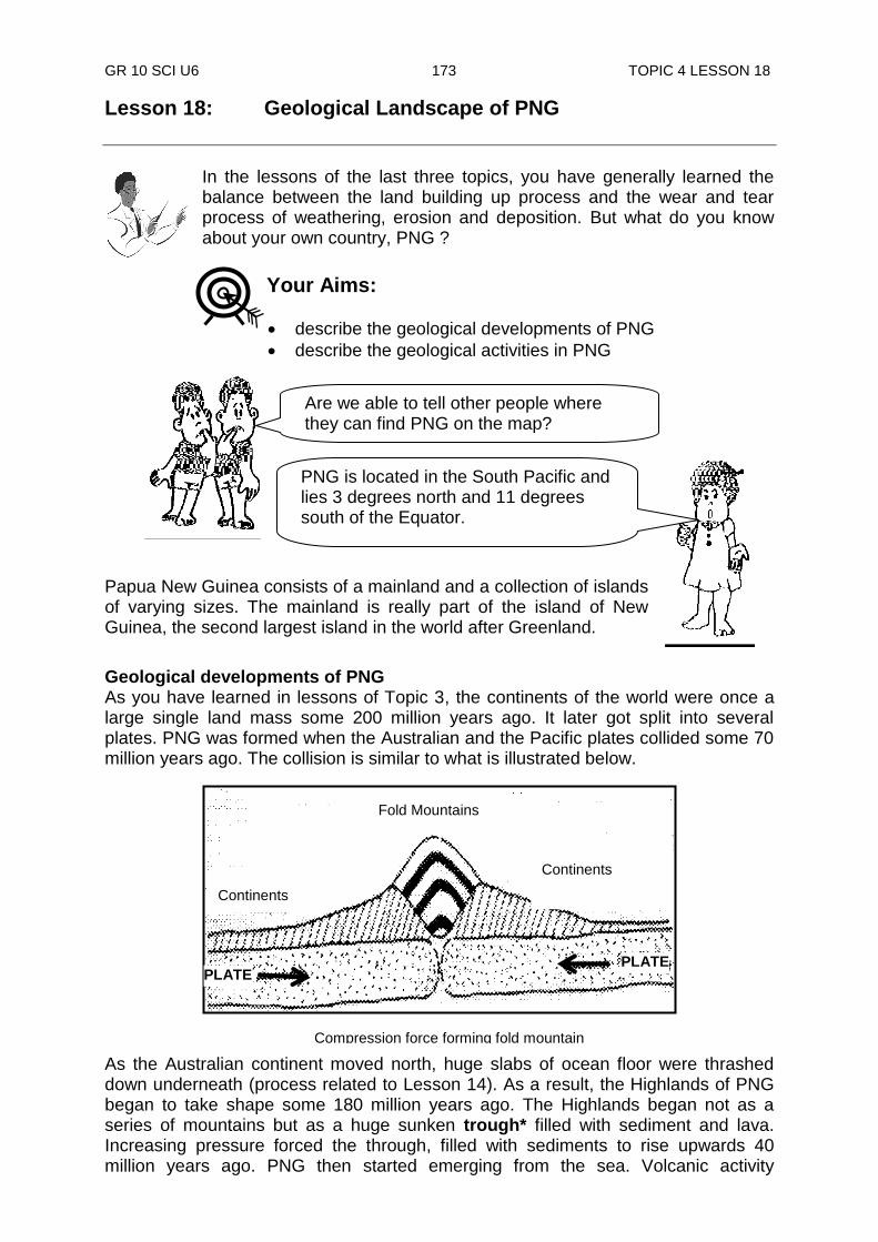
GR 10 SCI U6 173 TOPIC 4 LESSON 18
Are we able to tell other people where they can find PNG on the map?
PNG is located in the South Pacific and lies 3 degrees north and 11 degrees south of the Equator.
Lesson 18: Geological Landscape of PNG
In the lessons of the last three topics, you have generally learned the balance between the land building up process and the wear and tear process of weathering, erosion and deposition. But what do you know about your own country, PNG ?
Papua New Guinea consists of a mainland and a collection of islands of varying sizes. The mainland is really part of the island of New Guinea, the second largest island in the world after Greenland.
Geological developments of PNG As you have learned in lessons of Topic 3, the continents of the world were once a large single land mass some 200 million years ago. It later got split into several plates. PNG was formed when the Australian and the Pacific plates collided some 70 million years ago. The collision is similar to what is illustrated below. As the Australian continent moved north, huge slabs of ocean floor were thrashed down underneath (process related to Lesson 14). As a result, the Highlands of PNG began to take shape some 180 million years ago. The Highlands began not as a series of mountains but as a huge sunken trough* filled with sediment and lava. Increasing pressure forced the through, filled with sediments to rise upwards 40 million years ago. PNG then started emerging from the sea. Volcanic activity
Your Aims:
describe the geological developments of PNG
describe the geological activities in PNG
Fold Mountains
Continents
Continents
Compression force forming fold mountain
PLATE PLATE
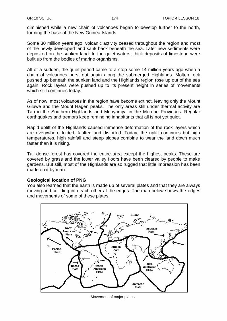
GR 10 SCI U6 174 TOPIC 4 LESSON 18
diminished while a new chain of volcanoes began to develop further to the north, forming the base of the New Guinea Islands. Some 30 million years ago, volcanic activity ceased throughout the region and most of the newly developed land sank back beneath the sea. Later new sediments were deposited on the sunken land. In the quiet waters, thick deposits of limestone were built up from the bodies of marine organisms. All of a sudden, the quiet period came to a stop some 14 million years ago when a chain of volcanoes burst out again along the submerged Highlands. Molten rock pushed up beneath the sunken land and the Highlands region rose up out of the sea again. Rock layers were pushed up to its present height in series of movements which still continues today. As of now, most volcanoes in the region have become extinct, leaving only the Mount Giluwe and the Mount Hagen peaks. The only areas still under thermal activity are Tari in the Southern Highlands and Menyamya in the Morobe Provinces. Regular earthquakes and tremors keep reminding inhabitants that all is not yet quiet. Rapid uplift of the Highlands caused immense deformation of the rock layers which are everywhere folded, faulted and distorted. Today, the uplift continues but high temperatures, high rainfall and steep slopes combine to wear the land down much faster than it is rising. Tall dense forest has covered the entire area except the highest peaks. These are covered by grass and the lower valley floors have been cleared by people to make gardens. But still, most of the Highlands are so rugged that little impression has been made on it by man. Geological location of PNG You also learned that the earth is made up of several plates and that they are always moving and colliding into each other at the edges. The map below shows the edges and movements of some of these plates.
Movement of major plates
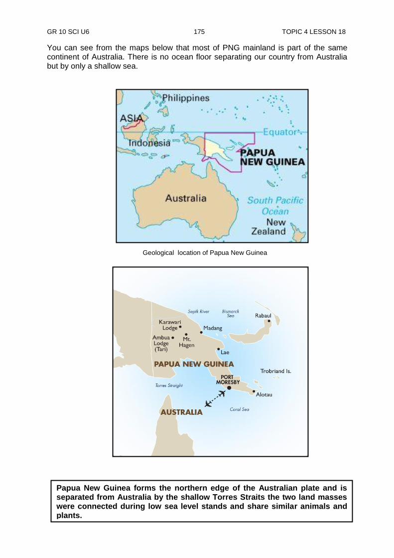
GR 10 SCI U6 175 TOPIC 4 LESSON 18
You can see from the maps below that most of PNG mainland is part of the same continent of Australia. There is no ocean floor separating our country from Australia but by only a shallow sea.
Papua New Guinea forms the northern edge of the Australian plate and is separated from Australia by the shallow Torres Straits the two land masses were connected during low sea level stands and share similar animals and plants.
Geological location of Papua New Guinea

GR 10 SCI U6 176 TOPIC 4 LESSON 18
Geological activities in PNG Looking at the map below, the area north of PNG is actually right on the edge where the Pacific and Australian plates meet. This is why we continue to have a lot of earthquakes and volcanic activities concentrated in PNG. The southern part of PNG is part of the Australian continent and so there is little earthquake activity and no active volcanoes. A detailed study of the geological activities in PNG is complicated and difficult to understand. This is due largely to several smaller plates whose outlines and movements which are hard to detect and explain. The following maps show one interpretation of this situation. The maps above show PNG being broken off at the collision zones into three smaller plates. They are the North Bismarck plate and the Solomon Sea plate. Almost all of the Northern Zone and the New Guinea Islands are very close to the edge of the plate where earth movements are at its greatest.
Papua New Guinea is right on the edge where Pacific and Australia plates meet
PNG being broken off at the collision zones into three smaller plates
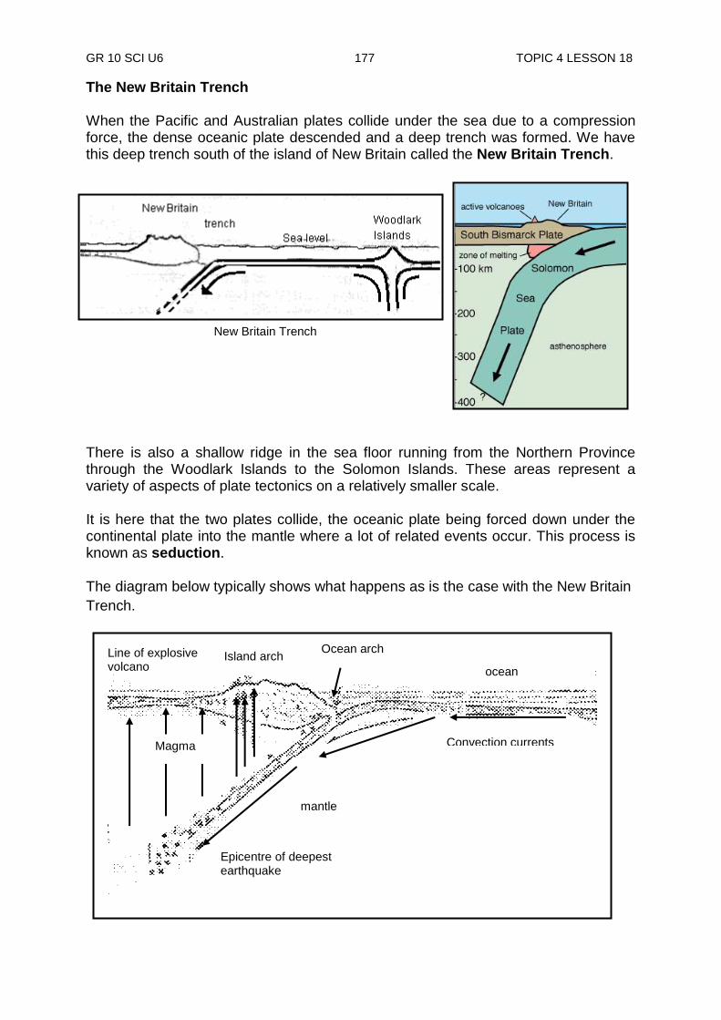
GR 10 SCI U6 177 TOPIC 4 LESSON 18
The New Britain Trench When the Pacific and Australian plates collide under the sea due to a compression force, the dense oceanic plate descended and a deep trench was formed. We have this deep trench south of the island of New Britain called the New Britain Trench.
There is also a shallow ridge in the sea floor running from the Northern Province through the Woodlark Islands to the Solomon Islands. These areas represent a variety of aspects of plate tectonics on a relatively smaller scale. It is here that the two plates collide, the oceanic plate being forced down under the continental plate into the mantle where a lot of related events occur. This process is known as seduction. The diagram below typically shows what happens as is the case with the New Britain
Trench.
New Britain Trench
Magma
Ocean arch
ocean
Line of explosive volcano
Island arch
Epicentre of deepest earthquake
mantle
Convection currents
GR 10 SCI U6 178 TOPIC 4 LESSON 18
Mountains building due to Geological Activity Geological activities along the plate boundaries are usually associated with mountain building, resulting from rock masses colliding, igneous activity and so on. As such, PNG is certainly a mountains country. However, comparing with many other countries, our mountains are not really high as we think. Our highest mountain, Mt Wilhelm, is only 4500m high compared to 670 000 m, the width of the country. Mathematically speaking, when we compare the height to its width (4500÷670 000=0.0067), Mt Wilhelm is even less than 1 mm (0.067 mm) high. Tropical climate has reduced the exposed rock mountains to layers of soil several metres thick. This is swept down by fast flowing rivers through deep gorges and laid to rest at the flood plains below. Because PNG acts as the battlefield for the Australian and Pacific plates, we must expect some events to happen every time.
NOW DO PRACTICE EXERCISE 18 ON THE NEXT PAGE.
Summary You have come to the end of lesson 18. In this lesson you have learnt that:
PNG lies at the edges of the Indian Australian and the Pacific plates. This is why we continue to have a lot of earthquakes and volcanic activities.
most of these take place mainly along the northern end of the mainland.
a detailed study of geological activities in PNG is very complicated because movements and outlines of several smaller plates are hard to detect and explain.
PNG is a mountainous country but comparing to many other countries, our mountains are not really high as we think.

GR 10 SCI U6 179 TOPIC 4 LESSON 18
Practice Exercise 18
1. How was PNG formed? ______________________________________________________________ 2. How were the New Guinea Islands formed? ______________________________________________________________ 3. How was the main backbone (the Highlands) formed? ______________________________________________________________ 4. List three things that combine to wear down land faster in the Highlands; i) ___________________ ii)_______________ iii)_________________ 5. What form of vegetables is found on the highest mountain peaks of the Highlands? ______________________________________________________________ 6. Name the continent which PNG belong to. ______________________________________________________________ 7. Give one reason as to why Australia does not experience a lot of earthquakes
and volcanic activities than PNG? ______________________________________________________________ 8. Geological activities in PNG are complicated and very hard to be fully
understood. Explain why this is so. ______________________________________________________________ 9. List the three PNG plates. i) ____________________ ii) _________________ iii) ________________ 10. Name the highest mountain in PNG and its height in kilometres. Name: ________________________ Its height: ______________________
CHECK YOU WORK. ANSWERS ARE AT THE END OF TOPIC 4
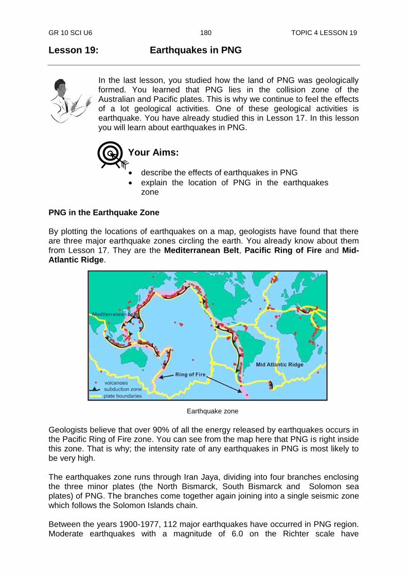
GR 10 SCI U6 180 TOPIC 4 LESSON 19
Lesson 19: Earthquakes in PNG
In the last lesson, you studied how the land of PNG was geologically formed. You learned that PNG lies in the collision zone of the Australian and Pacific plates. This is why we continue to feel the effects of a lot geological activities. One of these geological activities is earthquake. You have already studied this in Lesson 17. In this lesson you will learn about earthquakes in PNG.
PNG in the Earthquake Zone By plotting the locations of earthquakes on a map, geologists have found that there are three major earthquake zones circling the earth. You already know about them from Lesson 17. They are the Mediterranean Belt, Pacific Ring of Fire and Mid-Atlantic Ridge. Geologists believe that over 90% of all the energy released by earthquakes occurs in the Pacific Ring of Fire zone. You can see from the map here that PNG is right inside this zone. That is why; the intensity rate of any earthquakes in PNG is most likely to be very high. The earthquakes zone runs through Iran Jaya, dividing into four branches enclosing the three minor plates (the North Bismarck, South Bismarck and Solomon sea plates) of PNG. The branches come together again joining into a single seismic zone which follows the Solomon Islands chain. Between the years 1900-1977, 112 major earthquakes have occurred in PNG region. Moderate earthquakes with a magnitude of 6.0 on the Richter scale have
Your Aims:
describe the effects of earthquakes in PNG
explain the location of PNG in the earthquakes zone
Mediterranean belt
Earthquake zone
Mediterranean belt
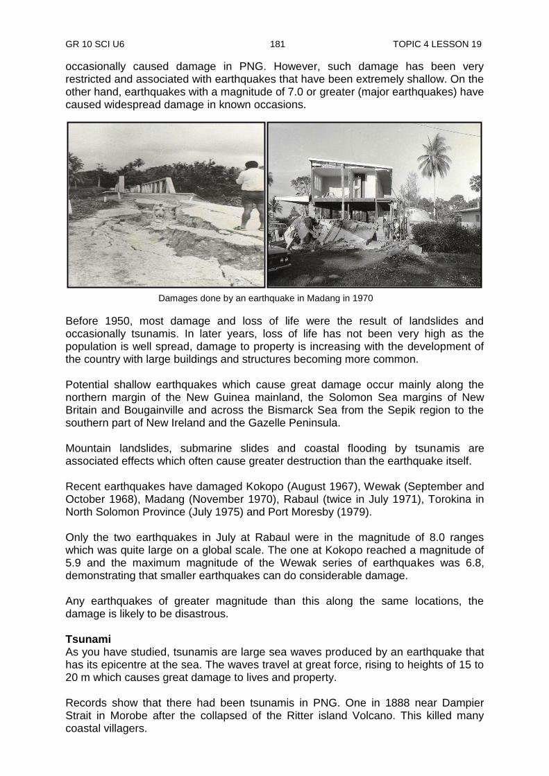
GR 10 SCI U6 181 TOPIC 4 LESSON 19
occasionally caused damage in PNG. However, such damage has been very restricted and associated with earthquakes that have been extremely shallow. On the other hand, earthquakes with a magnitude of 7.0 or greater (major earthquakes) have caused widespread damage in known occasions.
Before 1950, most damage and loss of life were the result of landslides and occasionally tsunamis. In later years, loss of life has not been very high as the population is well spread, damage to property is increasing with the development of the country with large buildings and structures becoming more common. Potential shallow earthquakes which cause great damage occur mainly along the northern margin of the New Guinea mainland, the Solomon Sea margins of New Britain and Bougainville and across the Bismarck Sea from the Sepik region to the southern part of New Ireland and the Gazelle Peninsula. Mountain landslides, submarine slides and coastal flooding by tsunamis are associated effects which often cause greater destruction than the earthquake itself. Recent earthquakes have damaged Kokopo (August 1967), Wewak (September and October 1968), Madang (November 1970), Rabaul (twice in July 1971), Torokina in North Solomon Province (July 1975) and Port Moresby (1979). Only the two earthquakes in July at Rabaul were in the magnitude of 8.0 ranges which was quite large on a global scale. The one at Kokopo reached a magnitude of 5.9 and the maximum magnitude of the Wewak series of earthquakes was 6.8, demonstrating that smaller earthquakes can do considerable damage. Any earthquakes of greater magnitude than this along the same locations, the damage is likely to be disastrous. Tsunami As you have studied, tsunamis are large sea waves produced by an earthquake that has its epicentre at the sea. The waves travel at great force, rising to heights of 15 to 20 m which causes great damage to lives and property. Records show that there had been tsunamis in PNG. One in 1888 near Dampier Strait in Morobe after the collapsed of the Ritter island Volcano. This killed many coastal villagers.
Damages done by an earthquake in Madang in 1970
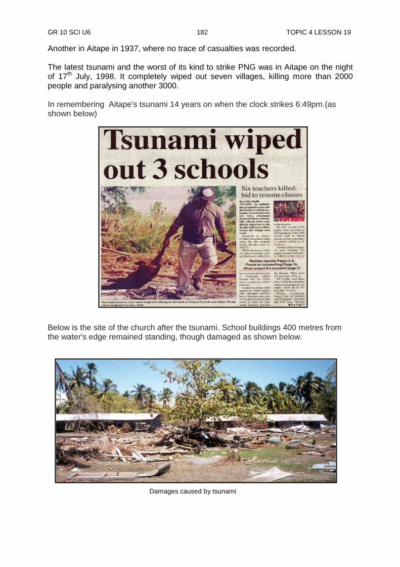
GR 10 SCI U6 182 TOPIC 4 LESSON 19
Another in Aitape in 1937, where no trace of casualties was recorded. The latest tsunami and the worst of its kind to strike PNG was in Aitape on the night of 17th July, 1998. It completely wiped out seven villages, killing more than 2000 people and paralysing another 3000. In remembering Aitape's tsunami 14 years on when the clock strikes 6:49pm.(as shown below) Below is the site of the church after the tsunami. School buildings 400 metres from the water's edge remained standing, though damaged as shown below.
Damages caused by tsunami
GR 10 SCI U6 183 TOPIC 4 LESSON 19
NOW DO PRACTICE EXERCISE 19 ON THE NEXT PAGE.
Summary You have come to the end of lesson 19. In this lesson you have learnt that:
the three major earthquake zones circling the earth are the Mediterranean Belt, Pacific Ring of Fire and Mid-Atlantic Ridge.
PNG is right inside the Pacific Ring of Fire earthquake zone.
90% of all energy released by earthquakes occur in the Pacific Ring of Fire zone.
shallow earthquakes causing great damage in PNG occurs mainly along the northern margin of the New Guinea mainland, Solomon Sea margins of New Britain and Bougainville and across the Bismarck Sea from the Sepik region to the southern part of New Ireland and Gazelle Peninsula.
tsunamis have hit PNG with casualties at times. The latest and the worst of its kind was in Aitape on 17th July, 1998. It completely wiped out seven villages, killing more than 2000 people.

GR 10 SCI U6 184 TOPIC 4 LESSON 19
Practice Exercise 19
Answer the following questions on the spaces provided. 1. List the three major earthquake zones i) _____________________ ii) _____________________ iii) _____________ 2. (i) Which of these earthquake zones in number 1 does PNG lie? _________________________________________________________
(ii) Which of these zones is the most active zone? _________________________________________________________
(iii) What is the rate of energy released by earthquakes occur in this zone? _________________________________________________________ 3. There were two major earthquakes, one after another in one month at Rabaul.
(i) In what month and year did that occur? _________________________
(ii) What was their range of magnitude? ___________________________ 4. (i) What is the name given to a large sea wave produced by an
earthquake? _________________________________________________________
(ii) One of these occurred in 1888 which killed many coastal villagers.
Where did this occur? _______________________________________
(iii) The recent and the worst of its kind to strike PNG killed more than 2000 people. Where did this occur? _______________________________________
(iv) When did this occur? _______________________________________
5. Earthquakes rarely cause destruction to lives and property. There are other things associated with earthquakes that cause destruction. List three of these.
(i) ____________________(ii) _____________________(iii) ______________
CHECK YOUR WORK. ANSWERS ARE AT THE END OF TOPIC 4.
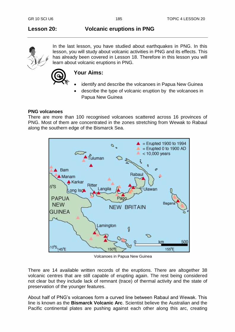
GR 10 SCI U6 185 TOPIC 4 LESSON 20
Lesson 20: Volcanic eruptions in PNG
In the last lesson, you have studied about earthquakes in PNG. In this lesson, you will study about volcanic activities in PNG and its effects. This has already been covered in Lesson 18. Therefore in this lesson you will learn about volcanic eruptions in PNG.
PNG volcanoes There are more than 100 recognised volcanoes scattered across 16 provinces of PNG. Most of them are concentrated in the zones stretching from Wewak to Rabaul along the southern edge of the Bismarck Sea.
There are 14 available written records of the eruptions. There are altogether 38 volcanic centres that are still capable of erupting again. The rest being considered not clear but they include lack of remnant (trace) of thermal activity and the state of preservation of the younger features. About half of PNG‟s volcanoes form a curved line between Rabaul and Wewak. This line is known as the Bismarck Volcanic Arc. Scientist believe the Australian and the Pacific continental plates are pushing against each other along this arc, creating
Volcanoes in Papua New Guinea
Your Aims:
identify and describe the volcanoes in Papua New Guinea
describe the type of volcanic eruption by the volcanoes in
Papua New Guinea
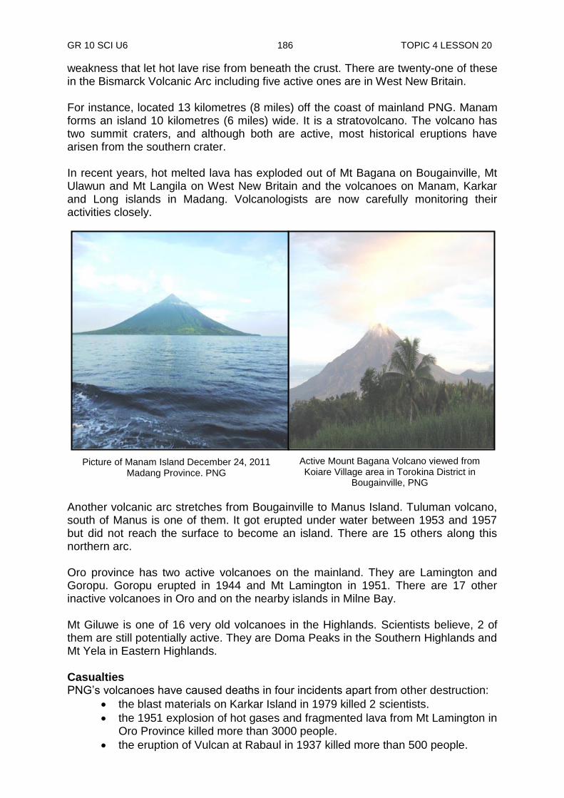
GR 10 SCI U6 186 TOPIC 4 LESSON 20
weakness that let hot lave rise from beneath the crust. There are twenty-one of these in the Bismarck Volcanic Arc including five active ones are in West New Britain. For instance, located 13 kilometres (8 miles) off the coast of mainland PNG. Manam forms an island 10 kilometres (6 miles) wide. It is a stratovolcano. The volcano has two summit craters, and although both are active, most historical eruptions have arisen from the southern crater. In recent years, hot melted lava has exploded out of Mt Bagana on Bougainville, Mt Ulawun and Mt Langila on West New Britain and the volcanoes on Manam, Karkar and Long islands in Madang. Volcanologists are now carefully monitoring their activities closely.
Another volcanic arc stretches from Bougainville to Manus Island. Tuluman volcano, south of Manus is one of them. It got erupted under water between 1953 and 1957 but did not reach the surface to become an island. There are 15 others along this northern arc. Oro province has two active volcanoes on the mainland. They are Lamington and Goropu. Goropu erupted in 1944 and Mt Lamington in 1951. There are 17 other inactive volcanoes in Oro and on the nearby islands in Milne Bay. Mt Giluwe is one of 16 very old volcanoes in the Highlands. Scientists believe, 2 of them are still potentially active. They are Doma Peaks in the Southern Highlands and Mt Yela in Eastern Highlands. Casualties PNG‟s volcanoes have caused deaths in four incidents apart from other destruction:
the blast materials on Karkar Island in 1979 killed 2 scientists.
the 1951 explosion of hot gases and fragmented lava from Mt Lamington in Oro Province killed more than 3000 people.
the eruption of Vulcan at Rabaul in 1937 killed more than 500 people.
Picture of Manam Island December 24, 2011 Madang Province. PNG
Active Mount Bagana Volcano viewed from Koiare Village area in Torokina District in
Bougainville, PNG
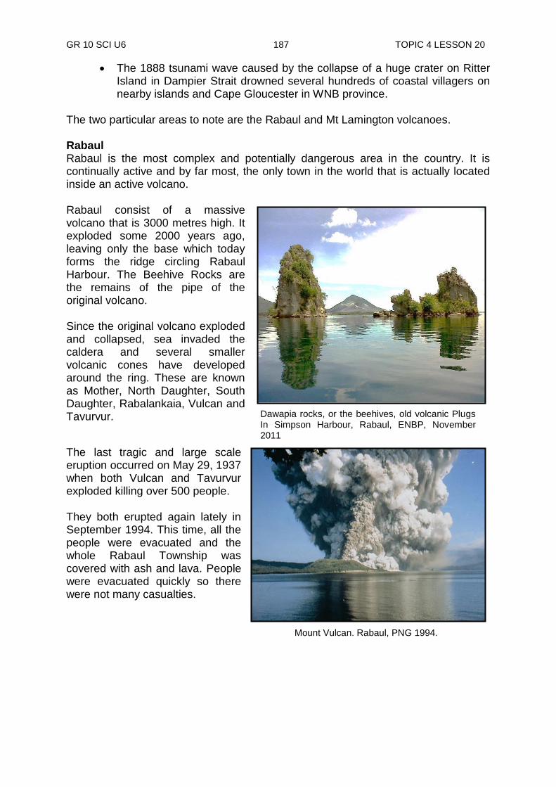
GR 10 SCI U6 187 TOPIC 4 LESSON 20
The 1888 tsunami wave caused by the collapse of a huge crater on Ritter Island in Dampier Strait drowned several hundreds of coastal villagers on nearby islands and Cape Gloucester in WNB province.
The two particular areas to note are the Rabaul and Mt Lamington volcanoes. Rabaul Rabaul is the most complex and potentially dangerous area in the country. It is continually active and by far most, the only town in the world that is actually located inside an active volcano. Rabaul consist of a massive volcano that is 3000 metres high. It exploded some 2000 years ago, leaving only the base which today forms the ridge circling Rabaul Harbour. The Beehive Rocks are the remains of the pipe of the original volcano. Since the original volcano exploded and collapsed, sea invaded the caldera and several smaller volcanic cones have developed around the ring. These are known as Mother, North Daughter, South Daughter, Rabalankaia, Vulcan and Tavurvur.
The last tragic and large scale eruption occurred on May 29, 1937 when both Vulcan and Tavurvur exploded killing over 500 people. They both erupted again lately in September 1994. This time, all the people were evacuated and the whole Rabaul Township was covered with ash and lava. People were evacuated quickly so there were not many casualties.
Dawapia rocks, or the beehives, old volcanic Plugs In Simpson Harbour, Rabaul, ENBP, November 2011
Mount Vulcan. Rabaul, PNG 1994.
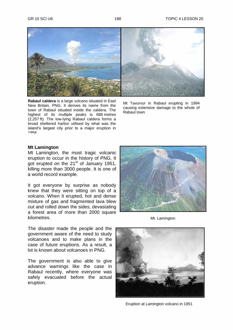
GR 10 SCI U6 188 TOPIC 4 LESSON 20
Mt Lamington Mt Lamington, the most tragic volcanic eruption to occur in the history of PNG. It got erupted on the 21st of January 1951, killing more than 3000 people. It is one of a world record example. It got everyone by surprise as nobody knew that they were sitting on top of a volcano. When it erupted, hot and dense mixture of gas and fragmented lava blew out and rolled down the sides, devastating a forest area of more than 2000 square kilometres. The disaster made the people and the government aware of the need to study volcanoes and to make plans in the case of future eruptions. As a result, a lot is known about volcanoes in PNG. The government is also able to give advance warnings like the case in Rabaul recently, where everyone was safely evacuated before the actual eruption.
Eruption at Lamington volcano in 1951
Mt Tavurvur in Rabaul erupting in 1994 causing extensive damage to the whole of Rabaul town
Rabaul caldera is a large volcano situated in East New Britain, PNG. It derives its name from the town of Rabaul situated inside the caldera. The highest of its multiple peaks is 688 metres (2,257 ft). The low-lying Rabaul caldera forms a broad sheltered harbor utilised by what was the island‟s largest city prior to a major eruption in 1994.
Mt. Lamington
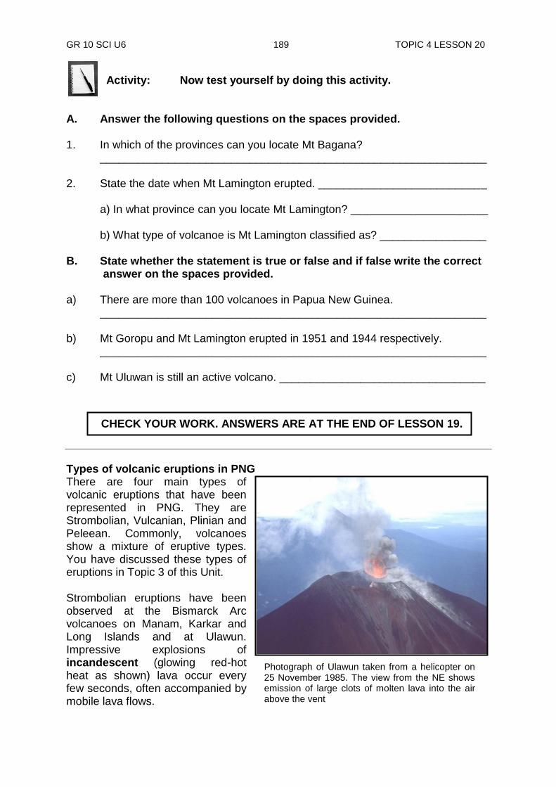
GR 10 SCI U6 189 TOPIC 4 LESSON 20
Activity: Now test yourself by doing this activity.
A. Answer the following questions on the spaces provided. 1. In which of the provinces can you locate Mt Bagana? ______________________________________________________________ 2. State the date when Mt Lamington erupted. ___________________________ a) In what province can you locate Mt Lamington? ______________________ b) What type of volcanoe is Mt Lamington classified as? _________________ B. State whether the statement is true or false and if false write the correct answer on the spaces provided. a) There are more than 100 volcanoes in Papua New Guinea. ______________________________________________________________ b) Mt Goropu and Mt Lamington erupted in 1951 and 1944 respectively. ______________________________________________________________ c) Mt Uluwan is still an active volcano. _________________________________
Types of volcanic eruptions in PNG There are four main types of volcanic eruptions that have been represented in PNG. They are Strombolian, Vulcanian, Plinian and Peleean. Commonly, volcanoes show a mixture of eruptive types. You have discussed these types of eruptions in Topic 3 of this Unit. Strombolian eruptions have been observed at the Bismarck Arc volcanoes on Manam, Karkar and Long Islands and at Ulawun. Impressive explosions of incandescent (glowing red-hot heat as shown) lava occur every few seconds, often accompanied by mobile lava flows.
CHECK YOUR WORK. ANSWERS ARE AT THE END OF LESSON 19.
Photograph of Ulawun taken from a helicopter on 25 November 1985. The view from the NE shows emission of large clots of molten lava into the air above the vent

GR 10 SCI U6 190 TOPIC 4 LESSON 20
Rabaul Eruption-Plinian Eruption
Rabaul caldera
The 1937 eruption of Vulcan volcano in Rabaul, in which more than 500 lives were lost has been interpreted as Plinian activity. Enormous quantities of gas and ash were released but no lava flows were produced The most feared eruption is the Plebeian type. The Mt Lamington eruption in Oro Province is of this type. More than 3000 lives were lost, being one of a world record example. The characteristic feature here is a hot and dense mixture of gas and fragmented lava rolling down the volcanic sides, devastating enormous surface area. Volcanic structure in PNG The most common volcanic structures in PNG are the composite. These are constructed of both quite lava flows and exploded magma at intervals. After reaching a certain stage of growth, a huge depression is formed where the superstructure of the cone collapses, developing into a caldera. This happens as a result of the removal of a large mountain of magma from beneath the cone by eruption or withdrawal.
Rabaul is located inside the caldera of a large volcano. Vulcan, Tavurvur and Rabalankaia are its satellites cones of the original of which all are in fact active. The recent caldera formation was at the Ritter Island volcano in 1888. The structure merely collapsed without any form of volcanic activity.
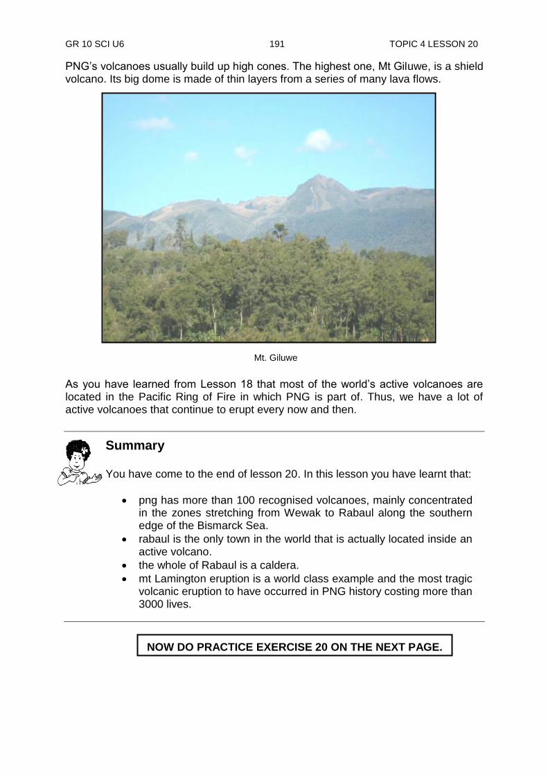
GR 10 SCI U6 191 TOPIC 4 LESSON 20
PNG‟s volcanoes usually build up high cones. The highest one, Mt Giluwe, is a shield volcano. Its big dome is made of thin layers from a series of many lava flows. As you have learned from Lesson 18 that most of the world‟s active volcanoes are located in the Pacific Ring of Fire in which PNG is part of. Thus, we have a lot of active volcanoes that continue to erupt every now and then.
NOW DO PRACTICE EXERCISE 20 ON THE NEXT PAGE.
Summary You have come to the end of lesson 20. In this lesson you have learnt that:
png has more than 100 recognised volcanoes, mainly concentrated in the zones stretching from Wewak to Rabaul along the southern edge of the Bismarck Sea.
rabaul is the only town in the world that is actually located inside an active volcano.
the whole of Rabaul is a caldera.
mt Lamington eruption is a world class example and the most tragic volcanic eruption to have occurred in PNG history costing more than 3000 lives.
Mt. Giluwe
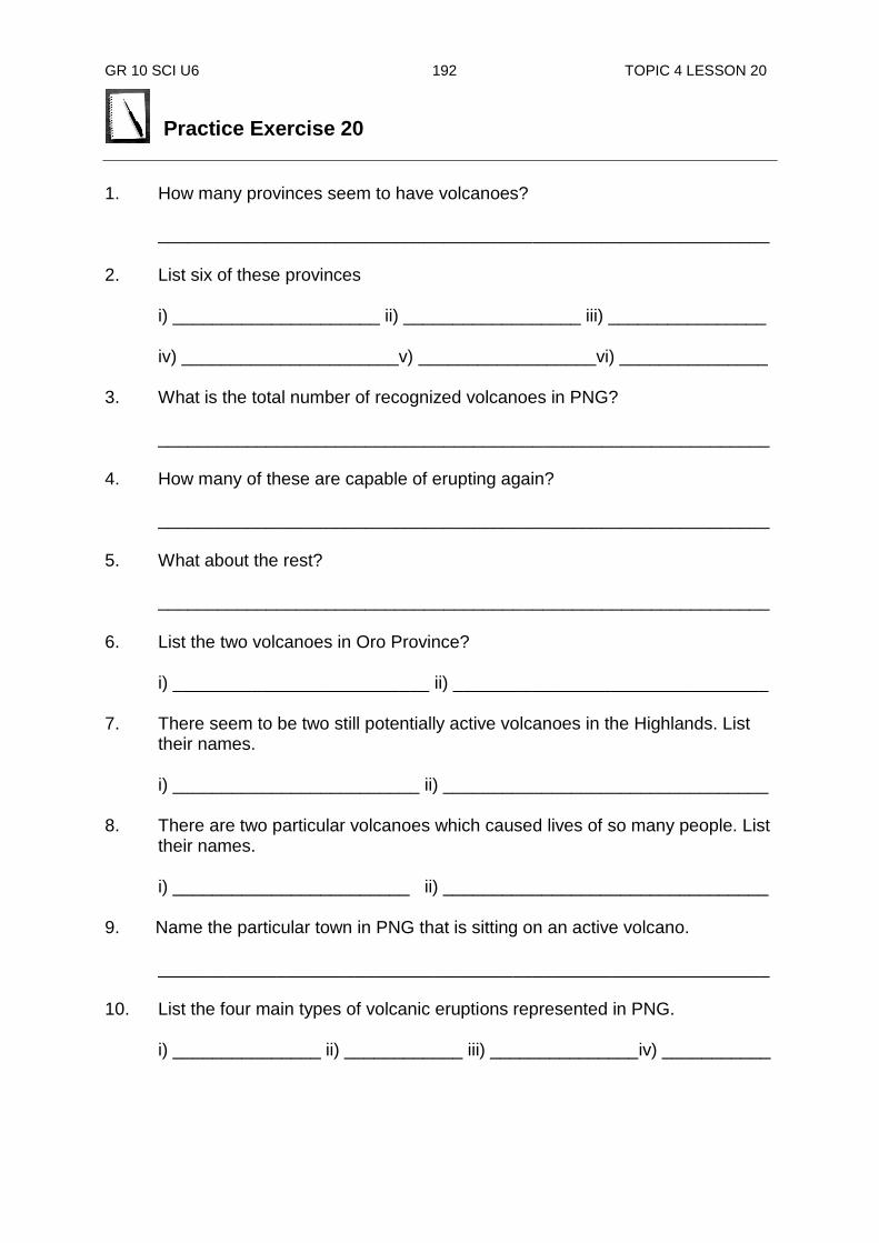
GR 10 SCI U6 192 TOPIC 4 LESSON 20
Practice Exercise 20
1. How many provinces seem to have volcanoes? ______________________________________________________________ 2. List six of these provinces
i) _____________________ ii) __________________ iii) ________________ iv) ______________________v) __________________vi) _______________
3. What is the total number of recognized volcanoes in PNG?
______________________________________________________________ 4. How many of these are capable of erupting again? ______________________________________________________________ 5. What about the rest? ______________________________________________________________ 6. List the two volcanoes in Oro Province? i) __________________________ ii) ________________________________ 7. There seem to be two still potentially active volcanoes in the Highlands. List
their names. i) _________________________ ii) _________________________________ 8. There are two particular volcanoes which caused lives of so many people. List
their names. i) ________________________ ii) _________________________________ 9. Name the particular town in PNG that is sitting on an active volcano.
______________________________________________________________ 10. List the four main types of volcanic eruptions represented in PNG.
i) _______________ ii) ____________ iii) _______________iv) ___________

GR 10 SCI U6 193 TOPIC 4 LESSON 20
Answers to Activity Part A 1. The Autonomous Region of Bougainville 2. On the 21st of January 1951. 3. Mt Lamington is classified as an active volcano. Part B a) True b) False. Mt Goropu and Mt Lamington erupted in 1951 and 1944 respectively. c) True
CHECK YOUR WORK. ANSWERS ARE AT THE END OF TOPIC 4
GR 10 SCI U6 194 ANSWERS TO PRACTICE EXERCISES
Answers to Practice Exercises 18 - 20
Practice Exercise 18 1. PNG was formed when the Australian and Pacific plates collided. 2. The New Guinea Islands were formed from a chain of volcanoes. 3. The main range (the Highlands) was formed from out of the sea. 4. i) high temperatures ii) high rainfall iii) steep slopes 5. grass 6. Most of PNG mainland is part of the same continent of Australia. 7. Because Australia is far away from the plate boundaries, (weak and unstable
areas of the crust). 8. Because, there are several smaller plates whose outlines and movements are
hard to detect and explain. 9. i) the North Bismarck plate ii) the South Bismarck plate
iii) the Solomon sea plate 10. Mt Wilhelm (4500 m high)
Practice Exercise 19 1. i) The Mediterranean Belt
ii) The Pacific Ring of Fire iii) The Mid-Atlantic Ridge 2. i) The Pacific Ring of Fire ii) The Pacific Ring of Fire ii) Over 90% 3. i) July 1971
ii) Magnitude of 8.0 range 4. i) Tsunami ii) Near Dampier Strait in Morobe
iii) Aitape iv) On 17th July, 1998
5. i) landslides ii) volcanic eruptions iii) tsunamis
GR 10 SCI U6 195 ANSWERS TO PRACTICE EXERCISES
Practice Exercise 20 1. 16 provinces 2. Madang, Manus, West Sepik, Oro, Southern Highlands, Western Highlands,
Enga, Central, Milne Bay, East New Briantian, Morobe, Bougainville, New Ireland (any six)
3. 100 recognised volcanoes 4. 38 volcanic cetres capables of erupting again 5. rest considered extinct 6. i) Mt Lamington ii) Goropu 7. i) Mt Gilwe ii) Doma Peaks 8. i) Mt Lamington ii) Rabaul 9. Rabaul 10. i) Strombolian ii) Peleean iii) Vulcanian iv) Plinian
REVISE TOPIC 4 USING THE MAIN POINTS ON THE NEXT PAGE.

GR 10 SCI U6 196 TOPIC 4 REVIEW
REVIEW OF TOPIC 4: Geological Activities in PNG
Now, revise all lessons in this Topic and then do ASSIGNMENT6. Here are the main points to help you revise. Lesson 18: Geological Landscape of PNG
PNG lies at the edges of the Indian Australian and the Pacific plates. This is why we continue to have a lot of earthquakes and volcanic activities.
Most of these take place mainly along the northern end of the mainland
A detailed study of geological activities in PNG is very complicated because movements and outlines of several smaller plates are hard to detect and explain.
PNG is a mountains country but comparing to many other countries, our mountains are not really high as we think.
Lesson 19: Earthquakes in PNG
The three major earthquake zones circling the earth are the Mediterranean Belt, Pacific Ring of Fire and the Mid-Atlantic Ridge.
PNG is right inside the Pacific Ring of Fire earthquake zone.
90% of all energy released by earthquakes occur in the Pacific Ring of Fire zone.
Shallow earthquakes causing great damage in PNG occurs mainly along the northern margin of the New Guinea mainland, the Solomon Sea margins of New Britain and Bougainville and across the Bismarck Sea from the Sepik region to the southern part of New Ireland and the Gazelle Peninsula.
Tsunamis do visit PNG with casualties at times. The latest and the worst of its kind were in Aitape on 17th July, 1998. It completely wiped out seven villages, killing more than 2000 people.
Lesson 20: Volcanic Eruptions
Papua New Guinea has more than 100 recognized volcanoes, mainly concentrated in the zones stretching from Wewak to Rabaul along the southern edge of the Bismarck Sea.
Rabaul is the only town in the world that is actually located inside an active volcano.
The whole of Rabaul is a caldera. Mt Lamington eruption is a world class example and the most tragic volcanic eruption to have occurred in PNG history costing more than 3000 lives.
NOW DO TOPIC TEST 4 TO COMPLETE ASSIGNMENT 6. RETURN IT TO THE PROVINCIAL COORDINATOR.

GR 10 SCI U6 197 GLOSSARY
GLOSSARY
A Aggregates (of a rock) consisting of a mixture of minerals separable by mechanical means. Aqueous (of rocks or sediments) formed of matter deposited in or by water. Asteroid Also called minor planet. Astronomy, any of the thousands of small bodies of from 480 miles (775 km) to less than one mile (1.6 km) in diameter that revolve about the sun in orbits lying mostly between those of Mars and Jupiter. C Collide To strike one another or one against the other with a forceful impact; come into violent contact; crash: Crystals A solid body having a characteristic internal structure and enclosed by symmetrically arranged plane surfaces, intersecting at definite and characteristic angles. A clear, transparent mineral or glass resembling ice. D Diversity The state or fact of being diverse; difference; unlikeness: variety; multiformity Ditches Long, narrow excavations made in the ground by digging, as for draining or irrigating land : trench. F Fragments Parts broken off or detached.
H Hazard (hazards,plural) Something causing unavoidable danger, peril, risk, or difficulty. I Iceberg A large floating mass of ice, detached from a glacier and carried out to sea. Infiltration Geology. the seepage of water into soil or rock M Molten Liquefied by heat; in a state of fusion; melted. P Plateau A land area having a relatively level surface considerably raised above adjoining land on at least one side, and often cut by deep canyons.
R Rumbled To make a deep, heavy, somewhat muffled, continuous sound, as thunder S Satellites Devices designed to be launched into orbit around the earth, another planet, the sun, and others. Synthetic Noting or pertaining to compounds formed through a chemical process by human agency, as opposed to those of natural origin. Shuffling A scraping movement; dragging gait.
GR 10 SCI U6 198 GLOSSARY
Stream(s) A body of water flowing in a channel or watercourse, as a river, rivulet, or brook.
T Tremor(s) Any tremulous or vibratory movement; vibration:
Trough A long, wide, and deep depression in the ocean floor having gently sloping sides, wider and shallower than a trench.
GR 10 SCI U6 199 REFERENCES
REFERENCES
Science Now Book 1 – Peter Stannard and Ken Williamson
Science Now Book 4 – Peter Stannard and Ken Williamson
Science Book 4
Australian Geological Survey Organisation (Photo by)
BBC
Dictionary.com
EM-DAT (2007): The OFDA/CRED
International Disaster Database Education Portal explorer
Keeping Watch on Volcanic Activities
Kenneth W. Fink /Photo, Researchers, Inc.
Mount Vulcan. Rabaul, PNG 1994.
Okeanos Explorer/Expedition/Gallery
R. Salgada (photo by)
Université Catholique de Louvain – Brussels – Belgium.
World Atlas.com
Wikipedia free encyclopedia – yahoo
aroundguide.com
https://study.com/academy/lesson/what-is-a-seismograph
https://www.google.com.pg/
newguineaconservation.org
netr.pmel.noaa.gov
ocean.noaa.gov
pg.geoview.intro
press.anu.edu.au
tripwow.tripadvisor.com
wallpaperswide.com
www.bigschocking.com
www.buzzle.com
www.earthobservatory.sg
www.foundationengineering.com
www.irinnews.org
www.mapsotheworld.com
www.panoramio.com
www.pngaa.net
www.studyblue.com

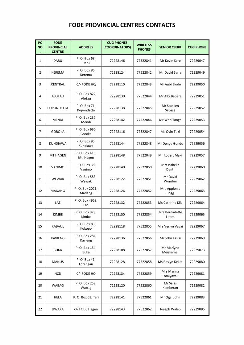
FODE PROVINCIAL CENTRES CONTACTS
PC NO
.
FODE PROVINCIAL
CENTRE ADDRESS
CUG PHONES (COORDINATORS)
WIRELESS PHONES
SENIOR CLERK CUG PHONE
1 DARU P. O. Box 68,
Daru 72228146 77522841 Mr Kevin Sere 72229047
2 KEREMA P. O. Box 86,
Kerema 72228124 77522842 Mr David Saria 72229049
3 CENTRAL C/- FODE HQ 72228110 77522843 Mr Aubi Elodo 72229050
4 ALOTAU P. O. Box 822,
Alotau 72228130 77522844 Mr Albi Bapera 72229051
5 POPONDETTA P. O. Box 71, Popondetta
72228138 77522845 Mr Stansen
Sevese 72229052
6 MENDI P. O. Box 237,
Mendi 72228142 77522846 Mr Wari Tange 72229053
7 GOROKA P. O. Box 990,
Goroka 72228116 77522847 Ms Ovin Tuki 72229054
8 KUNDIAWA P. O. Box 95,
Kundiawa 72228144 77522848 Mr Denge Gundu 72229056
9 MT HAGEN P. O. Box 418,
Mt. Hagen 72228148 77522849 Mr Robert Maki 72229057
10 VANIMO P. O. Box 38,
Vanimo 72228140 77522850
Mrs Isabella Danti
72229060
11 WEWAK P. O. Box 583,
Wewak 72228122 77522851
Mr David Wombui
72229062
12 MADANG P. O. Box 2071,
Madang 72228126 77522852
Mrs Applonia Bogg
72229063
13 LAE P. O. Box 4969,
Lae 72228132 77522853 Ms Cathrine Kila 72229064
14 KIMBE P. O. Box 328,
Kimbe 72228150 77522854
Mrs Bernadette Litom
72229065
15 RABAUL P. O. Box 83,
Kokopo 72228118 77522855 Mrs Verlyn Vavai 72229067
16 KAVIENG P. O. Box 284,
Kavieng 72228136 77522856 Mr John Lasisi 72229069
17 BUKA P. O. Box 154,
Buka 72228108 77522857
Mr Marlyne Meiskamel
72229073
18 MANUS P. O. Box 41,
Lorengau 72228128 77522858 Ms Roslyn Keket 72229080
19 NCD C/- FODE HQ 72228134 77522859 Mrs Marina Tomiyavau
72229081
20 WABAG P. O. Box 259,
Wabag 72228120 77522860
Mr Salas Kamberan
72229082
21 HELA P. O. Box 63, Tari 72228141 77522861 Mr Ogai John 72229083
22 JIWAKA c/- FODE Hagen 72228143 77522862 Joseph Walep 72229085
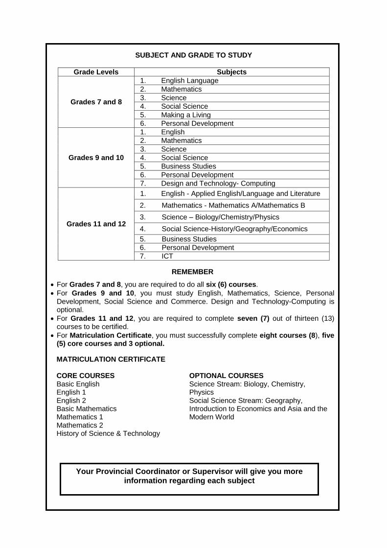
SUBJECT AND GRADE TO STUDY
Grade Levels Subjects
Grades 7 and 8
1. English Language
2. Mathematics
3. Science
4. Social Science
5. Making a Living
6. Personal Development
Grades 9 and 10
1. English
2. Mathematics
3. Science
4. Social Science
5. Business Studies
6. Personal Development
7. Design and Technology- Computing
Grades 11 and 12
1. English - Applied English/Language and Literature
2. 2. Mathematics - Mathematics A/Mathematics B
3. 3. Science – Biology/Chemistry/Physics
4. Social Science-History/Geography/Economics
5. Business Studies
6. Personal Development
7. ICT
MATRICULATION CERTIFICATE CORE COURSES Basic English English 1 English 2 Basic Mathematics Mathematics 1 Mathematics 2 History of Science & Technology
OPTIONAL COURSES Science Stream: Biology, Chemistry, Physics Social Science Stream: Geography, Introduction to Economics and Asia and the Modern World
REMEMBER
For Grades 7 and 8, you are required to do all six (6) courses.
For Grades 9 and 10, you must study English, Mathematics, Science, Personal Development, Social Science and Commerce. Design and Technology-Computing is optional.
For Grades 11 and 12, you are required to complete seven (7) out of thirteen (13) courses to be certified.
For Matriculation Certificate, you must successfully complete eight courses (8), five (5) core courses and 3 optional.
Your Provincial Coordinator or Supervisor will give you more
information regarding each subject