Embed Size (px)
DESCRIPTION
GEOLOGICAL CONCEPTUAL MODEL
Citation preview

OPERATIONAL PROGRAMME SLOVENIA-HUNGARY 2007-2013
GEOLOGICAL CONCEPTUAL MODEL
within the framework of project
Screening of the geothermal utilization, evaluation of the thermal groundwater bodies and preparation of the joint aquifer management
plan in the Mura-Zala basin
T-JAM

Project co-workers on this report:
Geološki zavod Slovenije (GeoZS)
Magyar Állami Földtani Intézet (MÁFI)
Report prepared by:
László Fodor, Ph.D. (MÁFI) András Uhrin, Ph. D. (MÁFI)
Klára Palotás (MÁFI) Ildikó Selmeczi (MÁFI)
Annamária Nádor (MÁFI) Ágnes Tóth-Makk (MÁFI)
Péter Scharek (MÁFI) Igor Rižnar, Ph. D. (GeoZS) Mirka Trajanova (GeoZS)
Co-workers on this report:
Helena Rifelj (GeoZS) Bogomir Jelen, Ph. D. (GeoZS) Andrej Lapanje, M.Sc. (GeoZS)
Simon Mozetič (GeoZS) Judit Muráti (MÁFI) Tamás Budai (MÁFI) Tibor Tullner (MÁFI)
Director GeoZS: Director MÁFI:
Doc. Marko Komac, Ph.D. Tamás Fancsik, Ph.D.
Ljubljana, Budapest, 28.2.2011

Contents 1. Introduction 1 2. The project area 2 3. Geological model building methods 3
3.1. Scale 3 3.2. Correlation of rock types 3 3.3. Determination of geological horizons 4 3.4. Borehole re-evaluations 5
3.4.1. Interpretation of wire-line logs of ‘Pannonian’ formations 5 3.4.2. Lithological characteristics of formations 7
3.5. Seismic reflection profiles and their interpretation with OpenDtect software 10 3.6. Regional geological cross sections 11 3.7. Surface geological map 12
4. Geology of the area 13 4.1. The main structural units of the area 13 4.2. Structural evolution of the area 14 4.3. Pre-Cenozoic basement 22
4.3.1. The Penninic 23 4.3.2. The Graz Paleozoic and the Ikervár Unit 23 4.3.3. The Koralpe-Wölz Unit and derived mylonites 24 4.3.3.1. The Upper Austroalpine unit; the Kobansko and
Magdalensberg Formations 24 4.3.3.2. The Lower Austroalpine unit; the Pohorje Formation 25
4.3.4. The Transdanubian Range Unit, Magmatic-metamorphic zone 25 4.3.5. The Transdanubian Range Unit 26 4.3.5.1. The Ljutomer Belt 27 4.3.6. The Mid-Transdanubian Unit 27 4.3.7. The Tisza Unit 28
4.4. Eocene 28 4.5. Oligocene 29 4.6. Pre-Pannonian Miocene 29
4.6.1. Eggenburgian–Ottnangian 29 4.6.2. Karpatian–Lower Badenian 30 4.6.3. Badenian 31 4.6.4. Sarmatian 32
4.7. ‘Pannonian’ 34 4.8. Quaternary 42 4.9 Description of regional geological cross-sections 44
4.9.1. Geologic cross section P1 44 4.9.2. Geologic cross section P2 46 4.9.3. Geologic cross section P3 47 4.9.4. Geologic cross section P4 49 4.9.5. Geologic cross section P5 49 4.9.6. Geologic cross section P6 50 4.9.7. Geologic cross section P7 50 4.9.8. Geologic cross section P8 51 4.9.9. Geologic cross section P9 52
5. References 54

1. Introduction
The final goal of the T-JAM project is to establish a common, harmonized thermal water management strategy for the area of the Mura-Zala basin, which promotes the sustainable utilization of thermal groundwater bodies (divided by the Slovenian-Hungarian border but officially not delineated yet) and geothermal energy in the region.
The project intends to contribute to the solution of the problem of sustainable use of natural resources shared by neighbouring countries. The main carrying medium of geothermal energy is thermal groundwater, which flows along regional flow paths determined by geological structures independently of state borders. These large flow systems involve huge areas: the recharge areas are generally located in the mountains surrounding the basins, where rainwater is infiltrating, then warms up when it gets deeper and flows towards the natural or artificial draining points along geologically-hydrogeologically suitable units of the basin (Fig. 1). Thus only a joint, cross-border, harmonized management strategy can lead to the sustainable use of these resources. This is especially true for the (thermal) groundwater bodies divided by borders, where the possible negative effects (depression, decrease in yield and temperature) due to (over)exploitation in a given country arise in the neighbouring country and may lead to political-economical tension, which could be otherwise avoided by harmonized management strategies. The complex evaluation of cross-border groundwater bodies, their alignment to natural drainage boundaries is one of the fundamental ideas of the Water Frame Directive (2000/60/EC).
Fig. 1. Theoretical sketch of the geothermal flow systems of the Pannonian Basin and its environ
To solve these problems (e.g. where and how much thermal water can be abstracted so that the heat- and water recharge remains enough to sustain the dynamic balance of the system — temperature, pressure, yield) it is necessary to characterize, evaluate the geological, hydrogeological, geothermal and hydrogeochemical relations that determine the conditions of the thermal groundwater system of the region within a consistent system and is also suitable
1

to forecast changes. Conceptual models and — where it is possible and practical — the development of numeric models is a tool for doing such analyses in a uniform system. This requires building four, partly consecutive conceptual model versions:
geological, structural (spatial)model
hydrogeological (flow and transport) model
geothermal model (heat transport model)
hydrogeochemical model
In order to establish these models the following steps have to be done:
to delineate the investigated area
to determine the boundary conditions and suitable resolution of the geological, hydrogeological and geothermal units (“spatial discretization”) of the models
to establish the chronology of processes (“time discretization”)
to determine the natural and artificial processes which will be considered during modelling
This work phase is called conceptual model building and it also includes the critical revision of available studies from literature. The conceptual geological model intentionally concentrates on the spatial delineation of lithological units that have similar hydrogeological features (permeable, impermeable) (so-called hydrostratigraphic units), as well as on the spatial position of tectonic elements (e.g. damming zones) that modify the flow paths. These elements are shown in representative sections and maps. After determining the possible coefficients (boundary conditions) expert estimations are made about the possible flow paths, the changes of dissolved material, heat transport, heat flow and occasional water-rock interactions.
All possible alternatives have to be thought over when a conceptual model is built, different expert opinions have to be considered; sometimes totally opposite views will collide. It must be noted that while the geological model is built on grounds of the analysis of concrete data (boreholes, seismic profiles, etc.) and gives input information to the hydrogeological, geothermal and hydrochemical conceptual models, these latter ones may be altered several times depending on the results of numerical hydrogeological modelling, water analyses, etc. during later work phases and are finalized only after iteration.
2. The project area
The fund awarded in the frame of the Slovenian-Hungarian 2007-2013 Operative Program concerns the area Pomurje and Podravje regions in Slovenia and Vas and Zala counties in Hungary. After considering the geological-hydrogeological viewpoints, the boundary of the project area was drawn at the line of Szombathely in the north, the administrative borders of Vas and Zala counties in the east, the Croatian-Hungarian and the Slovenian-Croatian borders in the south and the line of Maribor and the Slovenian-Austrian border in the west within the authority region (Fig. 2).
2

Fig. 2. Area of the T-JAM project
In Hungary the bulk of the area is made up of the Zala Hills and in the north the 200-300
m high dissected Vas Hills, which continues towards Slovenia in the Moravska Hills and westwards in the ranges of the Pohorje Mts. The basically hilly surface is divided into parts by two significant plains/basins: in Hungary the Kerka plain, in Slovenia the Mura field.
3. Geological model building methods
3.1. Scale
The scale of the geological spatial model is 1: 100 000. This determined the data density to be evaluated, above all the number of boreholes to be used for constructing the geological horizons (see below).
3.2. Correlation of rock types
The correlation of the formations on both sides of the border, the harmonization of the Slovenian and Hungarian geological terminology was very important before starting any kind of geological evaluations. Concerning the Miocene (s.l.) formations this was done during the meeting held at the Geological Institute of Hungary in January, 2010 (Fig. 3).
3

Fig. 3. Correlation of the Miocene (s.l.) formations
3.3. Determination of geological horizons
The horizons necessary for the hydrogeological model were determined at the beginning of the project. These were primarily the boundary horizons of the ‘Pannonian’ basin-fill delta front and turbidite sandstone sequences that are important as thermal water reservoirs, horizons of the basement, the Pre-Pannonian Miocene, the Quaternary base and the surface geological map, which is necessary to determine infiltration.
Pre-Cenozoic basement
Pre-Pannonian Miocene map (bottom contour map of the Sarmatian and Badenian marine deposits)
bottom of the ‘Pannonian’ turbiditic sandstone sequence (base of the Szolnok / Lendava Formation)
bottom and top of the ‘Pannonian’ turbiditic sandstone sequence (top of the Szolnok Formation / boundary within the Lendava Formation)
bottom of ‘Pannonian’ delta front sands (base of the Újfalu Formation / base of the Mura Formation)
top of ‘Pannonian’ delta front sands (boundary within the Újfalu Formation / boundary within the Mura Formation)
Quaternary base
surface geological map
The compiled surfaces are given in grid format, the distribution of the geological elements (2D “shapes”) is given in shp format.
4

3.4. Borehole re-evaluations
The project area covers the Zala Basin, which is a hydrocarbon exploration area, so theoretically a lot of hydrocarbon-exploring boreholes have been available, although data confidentiality was an issue. The Hungarian part of the project area was divided into a 4x4 km grid according to the 1:100 000 scale condition and the deepest borehole in each grid was selected. Thus about 450 boreholes were re-evaluated. We also chose and re-evaluated another about 110 boreholes along the used seismic profiles.
An important goal was to re-evaluate the successions of thermal wells in the area. This meant further appr. 70 boreholes. Thus on the Hungarian part of the project area we re-evaluated the successions of altogether 777 boreholes for the expert database.
We basically used the structure of the borehole database of the Geological Institute of Hungary (MÁFI) during the re-evaluation. In addition to the main identifiers, we re-evaluated the ‘Pannonian’ and older Miocene rocks on formation level and gave their depth intervals. The rocks of the Pre-Cenozoic basement were not re-evaluated, they were put in the database with their original qualifications as in the MÁFI database. The covering Quaternary sediments were only partly re-evaluated. For the sake of the homogeneity of the database, the topmost layers had to be harmonized with the MÁFI 1:100 000 scale surface geological map. However, some formerly Quaternary qualified deposits turned out to be definitely Late ‘Pannonian’ alluvial sediments according to their well-log picture (see chapter “Lithological characteristics of formations”).
On the Slovenian side of project area we chose about 100 boreholes which were elaborated with a similar procedure described on the Hungarian side.
3.4.1. Interpretation of wire-line logs of ‘Pannonian’ formations
Identification of ‘Pannonian’ formations was carried out based on wire-log patterns characteristic for the formations (respectively their depositional environment). In the study area — as in most part of the country except for the marginal zones of the mountains —Pannonian successions include sedimentary environments ranging from the deep basin to the alluvial plain. Considering the lithology, in case of the predominant part of the deep wells, we had to reckon only with drilling chips, therefore, the analyses of wire-line logs played an important role in determining the facies.
The prevailing part of the off-shore sediments, deposited in the deep basin is represented by clayey silt of different carbonate content, marl and calcareous marl. In case of low carbonate content, SP (spontaneous potential) log and resistivity log show small deflections together with the gamma ray log (“clay line”). In case of calcareous marls SP log is quite similar to the previous type, whereas the resistivity log — compared to the former one — shows higher deflections of capricious distribution. These two types are characteristic of the Endrőd/Upper Špilje Formation.
The Szolnok/Lower Lendava Formation comprises turbiditic bodies derived from the re-deposition of the material from the shore-zone into the deep basins. Its wire-line log is characterized by fining-upward and coarsening-upward sequences (“bell-shaped” and “funnel-shaped” curves, as shown by the joint SP–resistivity logs). This comes from the rhytmicity of the systematically thinning-upward and thickening-upward sandstone intercalations. It can be generally distinguished without any problem, because both from the base and the top it is surrounded by pelites of a thickness of some tens of meters, or more.
5

The area between the inner basin and the coastal ramp is called “slope” in the Pannonian Basin, as well, and its sediments are classified into the Algyő/Upper Lendava Formation. Rocks belonging to the latter comprise more fine sands, thus — compared to the previous ones — the curve pair is of more “toothed” appearance. Sand interbeddings with a maximum thickness of some meters are frequent; in most cases they are of distal turbiditic facies. The intercalation of the 10–30 m thick, coarsening-upward sand bodies representing the progradation succession may indicate the actual water-level drop, suggesting that the site of deposition was temporarily shifted to the lower region of the shore face. Algyő/Upper Lendava and Szolnok/Lower Lendava Formations may alternate repeatedly in the very thick successions of the inner basin. Their delineation on the map depends primarily on the scale of visualization, and this is in connection with the local or regional character of evaluation/research. Successions of a thickness of some tens of meters (or even thicker), frequently occurring in slope facies and made up of the alternation of thin-bedded sand and clay, show a characteristic pattern. In this case the alternation is so frequent, that the curve does not run in accordance with clay pattern. As a result of this, a barrel-like image can be seen, which should not be confused with a thicker sand intercalation. Less frequently, almost directly above the Szolnok/Lower Lendava Formation coarsening-upward sand successions of the delta front can be observed; they already belong to the Újfalu/Mura Formation. If the sand beds of the Újfalu/Mura Formation above the Szolnok/Lower Lendava Formation are not thick or fine-grained, silty, the two formations can be distinguished only with difficulties, and it can be done consequently only with full knowledge of the area.
The Újfalu/Mura, Somló and Tihany Formations can be distinguished only with difficulties in the study area. According to its definition, the Újfalu/Mura Formation occurs in the Neogene basins of the Transdanubian region (and of the Great Hungarian Plain), and comprises successions of the delta plain made up of the frequent alternation of sandstone, silt and clay marl. The Tihany Formation and the Somló Formation — according to the definition — occur only in the marginal zones of the basins in the Transdanubian area; however, these have also been formed as a result of the sedimentation of the delta. In general, the Somló Formation is similar to the lower part of the Újfalu/Mura Formation of the inner basins, whereas the Tihany Formation is similar to its upper part. (Due to the above-mentioned uncertainty, in this work we use a somewhat different classification of formations, which will be discussed in the chapter dealing with the geological build-up of the Pannonian.) Sediments of the delta front (respectively the mouth bar) are sandy and made up of characteristically coarsening-upward and thickening-upward, smaller sandy cycles. Sediments of the delta plain are usually thin-bedded, and in environments — permanently covered with water — they frequently comprise coalified plant fragments and lignite strips. The boundary between the delta front and delta plain was drawn at the first fining-upward sand intercalation of distributary channel facies, characterized by a minimum thickness of 5–8 m. As a result of the slow subsidence of the basin and the filling up keeping pace with it — determined by the general tectonic position and sediment transport — the younger part of the ‘Pannonian’ succession is predominated by delta plain sediments in the study area. The wire-line log of the delta plain sediments are characterized by the permanent presence of 5–20 m-thick, coarsening-upward minor cycles, which can be regarded as the filling-up successions of the embayments located between delta tributaries. Contrary to the wire-line log of sediments of the alluvial plain, in this case a curve shape shows a pattern regularly returning to the “clay line” and a thin-bedded appearance of the sediments.
Fine-grained, flood-plain sediments of the alluvial plain are characterized by more diverse thicknesses and less-sorted, clay-silt-fine-grained sand composition. With respect to the T-
6

JAM project, sediments of the delta plain and delta front are distinguished in our work, since their hydrodynamic features are significantly different.
3.4.2. Lithological characteristics of formations
For hydrogeological modeling the further division of formations (occasionally characterized by a thickness ranging from several hundred meters to a thousand meters), based on their lithologic variability, was an important aspect. Considering lithologic variability, formations were divided into intervals of a minimum thickness of 30 m. Considering ‘Pannonian’ formations, in the course of lithologic division of a formation, facies codes identifying the sedimentary environment were used (Fig. 4), whereas in case of pre-Pannonian Miocene formations, certain lithology codes (Fig. 5) were created. The thicknesses of lithologic subunits within a particular formation are given in meters (‘from’, ‘to’) in the borehole database (Fig. 6).
This type of lithological subdivision was made only for the Hungarian part of the project area, as data availability (especially geophysical logs) in Slovenia was not sufficient for such detailed studies. In the Slovenian only the major depositional units/formations were identified.
Code Sedimentary environment Formation (SLO)
Formation (HUN) Lithological description
Plc delta plain or alluvial plain upper Mura Fm
Zagyva & upper Újfalu Fms
alternation of fining-upward sandbodies (some of them are thicker than 10 m), silt and clay
Plf delta plain or alluvial plain upper Mura Fm
Zagyva & upper Újfalu Fms
alternation of fining-upward sandbodies (none of them exceeds thickness of 10 m), silt and clay
Frc delta front lower Mura Fm lower Újfalu Fm
alternation of coarsening-upward sandbodies (some of them are thicker than 10 m), silt and clay
Frf delta front lower Mura Fm lower Újfalu Fm
alternation of coarsening-upward sandbodies (none of them exceeds thickness of 10 m), silt and clay
Sl slope upper Lendava Fm Algyő Fm silt and clay with only insignificant sand intercalations
Tuc turbidites lower Lendava Fm Szolnok Fm alternation of sandbodies (some of them are thicker than 10 m) with silt and clay
Tuf turbidites lower Lendava Fm Szolnok Fm alternation of sandbodies (none of them exceeds thickness of 10 m) with silt and clay
Dw deepwater, no turbidites Špilje Fm Endrőd Fm
clay marl and marl with only insignificant sand intercalations
Fig. 4. Lithology codes used for ‘Pannonian’ formations
7

Lithology Detailed lithology Lithology
code Detailed lithology codes
clay variegated, bentonitic, kaolinitic, coaly, red, bauxitic, silty, sandy, pebbly
Cl vCl, bCl, kCl, cCl, rCl, bxCl, siCl, sdCl, pCl
claystone silty Clst siClst mud (clay and silt) clayey, sandy, pebbly, calcareous,
lime mud M clM, sdM, pM, caM, lM
mudstone clayey, sandy, pebbly, calcareous Mst clMst, sdMst, pMst, caMst silt clayey, sandy Si clSi, sdSi siltstone clayey, sandy Sist clSist, sdSist shale Sh sand muddy, silty, pebbly, clayey, algal Sd mSd, siSd, pSd, clSd, algSd sandstone muddy, silty, pebbly, clayey, algal,
marly Sdst mSdst, siSdst, pSdst, clSdst,
algSdst, mrlSdst gravel muddy, sandy, calcareous Gr mGr, sdGr, caGr conglomerate muddy, sandy, calcareous Cong mCong, sdCong, caCong breccia dolomite, limestone, quartz Br dolBr, lstBr, qBr marl calcareous, clay, silty, sandy, algal,
tuffaceous Mrl caMrl, clMrl, siMrl, sdMrl,
algMrl, tMrl limestone algal, detrital, pebbly, sandy, clayey,
marly Lst algLst, detLst, pLst, sdLst,
clLst, mrlLst coal Coal tuffaceous bentonite, XXX t tBen, tXXX tuff bentonitic T bT agglomerate Agg kaolin, kaolinite K bauxite Bx andesite, basalt, dacite
A, Ba, D
agmatic Magm alternations e.g. clay/sand, sand/conglomerate/silt e.g. Cl/Sd, Sd/Cong/Si
Fig. 5. Lithology codes used for pre-Pannonian Miocene formations
8

geology_id borehole_id from to geo_ndx lito from lito to lito
Zm-3 Zalaszentmihály 0,00 10,00 pd_Qp3-h 0,00 10,00 pd_Qp3-h
10,00 315,00 zPa2 10,00 30,00 n.d.
10,00 315,00 zPa2 30,00 120,00 Plc
10,00 315,00 zPa2 120,00 180,00 Plf
10,00 315,00 zPa2 180,00 210,00 Plc
10,00 315,00 zPa2 210,00 270,00 Plf
10,00 315,00 zPa2 270,00 315,00 Plc
315,00 870,00 so-tPa2 315,00 360,00 Plc
315,00 870,00 so-tPa2 360,00 420,00 Plf
315,00 870,00 so-tPa2 420,00 450,00 Plc
315,00 870,00 so-tPa2 450,00 540,00 Plf
315,00 870,00 so-tPa2 540,00 630,00 Plc
315,00 870,00 so-tPa2 630,00 660,00 Plf
315,00 870,00 so-tPa2 660,00 690,00 Plc
315,00 870,00 so-tPa2 690,00 840,00 Plf
315,00 870,00 so-tPa2 840,00 870,00 Plc
870,00 935,00 úPa1-2 870,00 900,00 Frc
935,00 1650,00 aPa1-2 900,00 935,00 Frf
935,00 1650,00 aPa1-2 935,00 1170,00 Sl
935,00 1650,00 aPa1-2 1170,00 1200,00 Tuf
935,00 1650,00 aPa1-2 1200,00 1230,00 Tuc
935,00 1650,00 aPa1-2 1230,00 1290,00 Tuf
935,00 1650,00 aPa1-2 1290,00 1320,00 Tuc
935,00 1650,00 aPa1-2 1320,00 1350,00 Tuf
935,00 1650,00 aPa1-2 1350,00 1410,00 Tuc
935,00 1650,00 aPa1-2 1410,00 1650,00 Sl
1650,00 1732,00 szPa1 1650,00 1680,00 Tuf
1650,00 1732,00 szPa1 1680,00 1732,00 Tuc
1732,00 1763,00 eMs2-Pa1 1732,00 1763,00 Dw
1763,00 1790,00 kMs 1763,00 1778,00 sdMrl
1763,00 1790,00 kMs 1778,00 1790,00 Cong
1790,00 1916,00 szMb-lMb 1790,00 1916,00 sdMrl/caMrl/Lst
1916,00 1936,00 szMb 1916,00 1936,00 sdMrl
1936,00 1947,00 lMb 1936,00 1947,00 algLst
1947,00 1994,00 szMb 1947,00 1994,00 sdMrl
1994,00 2966,00 szE2-3 1994,00 2966,00 A
2966,00 3001,50 pE2-3 2966,00 3001,50 T/clMrl/Mrl
Fig. 6. An example for lithologic division of the formations in the borehole database
9

3.5. Seismic reflection profiles and their interpretation with OpenDtect software
47 2D seismic reflection profiles have been obtained from the Hungarian part of the project area; the total length of them is about 1000 km. The images of the profiles (received electronically), were visualized by the OpenDTect software. This software provides the possibility to track identifiable faults or horizons (formation boundaries) on the profile, and to save their position — marked in the profile — in the form of a table. Such tables give information for the depth of a certain horizon or fault in discrete points of the profile occurring one after the other and identified in the Hungarian Coordinate System. These points can be used henceforward — in the same way as depth values derived from wells — in compiling depth contour maps, or cross-sections. If the relation between the so-called two-way travel time (providing the vertical dimension of the seismic image) and the real depth is known, the tracks of wells located close to the sections, and horizons marked on them can also be displayed: these may give further help for the designation of formation boundaries in the seismic profile.
Resolution of seismic reflection profiles — depending on their quality — is some tens of meters both vertically and horizontally; thus, layers thinner than this value cannot be separated in them. However, from the seismic reflection pattern (e.g. reflection contrast and continuity) of certain units the presence or absence of much smaller details, e. g. sand bodies of turbidity or channel-bed origin, can be concluded.
The vertical dimension means time; therefore, the position of the exported horizons and faults should subsequently be converted to depth data. Depth conversion is more difficult because the different parts of the area are characterized by significantly different depth–time relations. Because of this, from each area boreholes — characterized by the highest, the lowest and medium seismic-wave velocities — were chosen, from which exact depth–time functions were known, and in the areas between them depth data were generated from the differently weighted average of data derived from the above-mentioned three functions. As a first step, weight factors used for averaging were assessed for the localities of about 100 wells, based on the depths of the stratigraphic levels identifiable both on the seismic profiles and in well-logs (e.g. the boundary between the Algyő Formation and the Újfalu Formation, or the base of the clastic basin-fill succession): the weight factors were changed until we got the best possible accordance between the depth-converted two-way travel times and the depth values determined from the well-logs. From the above mentioned approximately 100 data a grid covering the entire area was obtained by kriging, which gives a depth-time relation appropriate for the entire area.
It is worth mentioning, that for the real depth of units occurring below the clastic basin-fill sediments (predominantly of ‘Pannonian’ and subordinately of pre-Pannonian Miocene age) a rough approximation can be given due to their lateral heterogeneity; going deeper the mistake in estimation may increase to several hundreds of metres. Within the basin-fill succession the depth of elements interpreted from seismic profiles can be estimated characteristically with an accuracy of some tens of meters.
Further possibilities of using the seismic method is due to the fact that the discrete horizons represent coeval sediments (the so-called ‘time-lines’). This makes it possible to trace sediments which are coeval with important levels (filtered section, lithostratigraphic boundary etc.) marked in the given wells. Sediments can be traced over the entire area in order to correlate boreholes or to find the place where a certain horizon crops out to the surface.
10

In the Slovenian part of the project area seismic section in digital format were not available. The major geological horizons needed for the model (chapter 3.3.) were marked on paper/hard-copy format on 11 seismic sections and this was used during editing different maps (Figs 12-22).
3.6. Regional geological cross sections
In order to get a more exact geological conception for the area, we compiled nine regional geological cross sections (Appendices I–V). Three in the ENE–WSW direction continue from Slovenia into Hungary (P1, P2, P3). Altogether six cross-sections were edited in a NW–SE direction, more or less parallel to each other; two of them in the Hungarian part (P4, P5) join each other (Fig. 7).
In the Hungarian part of the area cross-sections have been compiled based on the interpretation of composite seismic reflection profiles. As it was mentioned earlier, digital seismic sections were not available for the Slovenian part of the project area; therefore the Slovenian cross-sections were edited on the basis of assessment of a wide range of different datasets, as the following:
Previously constructed set of four cross sections prepared by JELEN et al. (2006); one NNE – SSW (P2) and the other three NNW – SSE oriented (P7, P8, P9).
Well logs interpretation by M. Jelen & H. Rifelj (Geo-ZS) and A. Uhrin (MÁFI)
Well logs interpretation by Nafta Lendava (geophysical markers and related formational boundaries)
Constructed delta front bottom map (A. Uhrin’s interpretation)
Surface lithostratigraphic and tectonic structural map of T-JAM project area, Northeastern Sslovenia (1:100 000) (JELEN & RIFELJ, 2011)
Structural map of the pre-Tertiary basement (1:100 000) (JELEN, 2010)
Provisional map of the pre-Tertiary basement relief and interpreted faults (JELEN, 2010)
Despite the different working methods the sections have been edited based on uniform concepts and represent the geological buildup of the area in a consistent way. Due to simplification of the cross-sections faults with offsets less than a few hundred metres are not showed.
11

Fig. 7. Tracks of the geological cross-sections
3.7. Surface geological map
From the point of view of hydrogeological modeling a unified surface geologic map is required in order to provide information for bedrock permeabilities.
For both the Slovenian and Hungarian parties surface geological maps for the study area at a scale of 1:100 000 were available, albeit neither their linework, nor their content (individual formations) were harmonized. In addition to the harmonization of linework, the preparation of a unified legend system required a considerable effort, because the two countries use legends of different conceptions. In Hungary the legend of geological maps is based on lithostratigraphy, the predominant part of rocks occurring in the country which are older than Quaternary, are classified into formations (or more precisely into members and beds). Quaternary sediments are classified primarily on the basis of genetics (their age, and further division is made based on lithology). These formations can be identified by geological indexes (indexes of the Hungarian Geological Map System (EOFT) on the map.
In Slovenia, every formation had a number on the original geological map, and in the legend geological age and lithological description was attached to the numbers. These units have been correlated with Hungarian formations, and in cases of no correspondence between Slovenian and Hungarian units, geological indexes was given to the Slovenian units, according to the Hungarian directions for creating geological indexes (Appendix VI).
Geological formations (compiled according to the unified guidelines) are depicted on the geological map of a scale of 1:100 000 (Appendix VII). Each formation is identified by a number and with a brief lithologic description in order to avoid extending the geological
12

index system to the Slovenian area. The geological map has not been cartographed, and is available on the project website (www.t-jam.eu).
4. Geology of the area
4.1. The main structural units of the area
The deepest Pre-Cenozoic structural unit of the region is the Penninic unit, which appears on the surface in the NW corner of the area and also constitutes the Pre-Cenozoic basement in the west. Different elements of the Austroalpine nappe system were thrust onto this unit during the Cretaceous, but their Cretaceous position was reorganized considerably by the Miocene extensional deformation. As a result, the Penninic is connected structurally with the higher elements of the Austroalpine nappe system, mainly the Graz Paleozoic. At the eastern boundary of the former, a smaller, newly defined unit, the Ikervár Unit is probably also a nappe (HAAS et al. 2010). The age of the rock formations is likely Mesozoic (Jurassic–Cretaceous?), but its stratigraphy and structural connections are not yet known properly.
The bulk of the project area in Hungary is located in the area of the Transdanubian Range. Its actual north-western limit is a Miocene strike-slip and normal fault system, while the original undeformed contact is supposed to be a Cretaceous nappe boundary according to its present-day interpretation (TARI 1994, FODOR & KOROKNAI 2000, HAAS et al. 2010). In the hanging wall of this thrust, the Transdanubian Range Unit appears as the uppermost Austroalpine nappe (TARI 1994, FODOR et al. 2003, TARI & HORVÁTH 2010). The Transdanubian Range Unit consists of Early Paleozoic low-grade metamorphic rocks and non-metamorphosed Permian–Cretaceous sedimentary sequences. In the southwest, below the Transdanubian Range Unit, two different metamorphic rock suites occur in the basement of the Mura Basin. One suite is a geeenshcist facies rock unit (Kobansko Fm.), the other is composed of the elements of the Koralpe-Pohorje-Wölz nappe system. This unit lies directly below the Pre-Cenozoic basement on the Murska Sobota block, while it reaches the surface farther to the west in the Pohorje Mts.
The southern boundary of the Transdanubian Range unit is the Periadriatic–Balaton Line (System or Zone). It is a Cenozoic strike-slip zone (KÁZMÉR & KOVÁCS 1985, BALLA 1988, TARI 1994, FODOR et al. 1998). Oligocene and Permian intrusions and rocks of various metamorphic grades appear within this zone (JÓSVAI et al. 2005). Some of the rock units were separated from the Transdanubian Range Unit, another part from unidentified (deeper?) units during the strike-slip deformation.In the western part of this zone, in Slovenia, a transitional unit, the Ljutomer (structural) Belt is introduced. It consists of Lower Triassic sedimentary rocks
Adjusted to the administrative border of the project area (boundary of Zala County), the southern part of the area (around Nagykanizsa) contains a small segment of the Mid-Transdanubian Unit. It is composed of several nappes and duplexes of presumably Cretaceous and/or Oligocene–Miocene age: South Karavanke, South Zala and Kalnik units; the former continues to the west in Slovenia. The southern boundary of this composite unit is the NE trending Mid-Hungarian Line, which runs at the southern corner of the area. Metamorphic rocks of the Tisza Unit, south of the Mid Hungarian Line appear just at the edge of the study area. According to the seismic sections, they are present more extensively below other units.
13

4.2. Structural evolution of the area
The studied area basically evolved as an effect of seven main structural phases. These are the Cretaceous nappe forming (D1), the Late Cretaceous basin evolution and the synchronous structural exhumation (D2), the late Oligocene–Early Miocene strike-slip and thrusting (D3), the late Early–Middle Miocene rifting (D4), the late Sarmatian strike-slip deformation (D5), the Late Miocene post-rift subsidence (D6) and the latest Miocene–Quaternary structural inversion (neotectonic phase) (D7).
One of the most significant phases is the compressional deformation (D1), which lead to the nappe structure of the pre-Cenozoic basement. It probably took place in several steps during the middle Cretaceous between the Albian and Coniacian (112–85 Ma). It resulted in the thrust of the Transdanubian Range upon the Koralpe-Pohorje-Wölz unit. The Graz Paleozoic and the small Ikervár unit also appear in some places between the two large units but they may thin out (wedge out) laterally.
The consequence of the compression within the Transdanubian Range Unit is the formation of imbricates and folds. Location of the imbricates, mapped by TARI (1994, 1995) and TARI & HORVÁTH (2010), was partly supported and partly modified here. In the Nagylengyel and Szilvágy the Hauptdolomite Fm. is thrusted upon Jurassic rocks. The strike of the imbricates and folds changes gradually from NE–SW to N–S in the basement of the southern-central part of the Zala Basin near the Slovenian border. The detachment faults at the bottom of the imbricates can be well traced on the seismic profiles (Fig. 8). These weakened zones could be reactivated during subsequent structural phases, especially during the Miocene rifting (Fig. 8). One of the best traceable thrust (imbricate boundary) can be identified around the Nádasd High: intercrossing seismic profiles show the very low-angle detachment fault there (Fig. 8). Here, a part of the Miocene normal faults cut through the Cretaceous thrust, while others flatten and detach to the thrust plane.
TARI (1994, 1995) thought the thrust planes to be continuous between the NW and SE side of the Transdanubian Range unit. We think that this cannot be verified below the Zala Basin because on the one hand the imbricate boundaries are covered by the Eocene of the Bak-Nova trough, and on the other hand, the Cretaceous imbricates are displaced by the northern branches of the Balaton Zone. Thus the Litér and Veszprém thrusts in the foreland of the Keszthely Hills in the eastern part of the area cannot be traced southwards but are terminated against the Balaton Zone.
The thrusts, imbricates are accompanied by folds. The Devecser-Sümeg and Tés-Halimba synclines, which are typical in the Transdanubian Range, can be followed in the northern part of the area. They were identified by TARI (1994) on the seismic profiles at Nagytilaj and Zalalövő. The cores of the synclines contain Jurassic–Early Cretaceous sedimentary rocks. The vertical or inverse layers around Sümeg can be connected to the southern syncline. Additional folds can be recognized in the Keszthely Hills on the basis of surface dip data (BUDAI et al. 1999) and folds can also be postulated on the basis of borehole data.
14

Fig. 8 View toward two, crosscutting seismic lines and their intersection line. The sections show the same Cretaceous thrust detachments and Miocene normal faults and tilted blocks. Note location on Fig. 9
The age of the deformation is well known, since the Aptian rocks are folded, while the Santonian deposits are hardly tilted. This striking angular unconformity was proved best in Sümeg (HAAS et al. 1984). The age of the compressional deformation characterized by thrusts is indicated by the youngest K/Ar ages measured on rock samples from the Graz Paleozoic (116 Ma, ÁRKAI & BALOGH 1989). The age of the Austroalpine nappe emplacement upon the Penninic is not known. The Paleogene age seems to be possible considering the underthrusted metamorphosed Penninic units of the Tauern Window.
In Slovenian part of the basement, the strongest mylonitization of the Koralpe-Pohorje-Wölz unit most probably took place at the time of an extensive Cretaceous thrusting of the deformational phase D1. Remnants of thrust sheets, reached by the borehole Šom-1/88, are ascribed to this event. Some of the shear planes were reactivated later: firstly at the time of
15
structural exhumation (D2), and at later thrusting and shearing of the D3 phase. Phyllonitized zones were formed, not associated to a certain lithology. Not only gneisses and micaschists but the amphibolites are also affected by phyllonitisation. Analogly with the Pohorje and Kobansko situation, the greenschist facies rocks (chlorite amphibole schists and phyllites) in some areas are phyllonitised as well. These rocks are known from some boreholes (Šal-2/79), although the drill-chippings determinations are questionable. The Šal-2/79, Nu-4 and 6/68, Fi-15-18/57-58 borholes data show that greenschists could be mistaken by mylonitized, retrogressed amphibolites, or vice versa.
Formation of the Senonian basins, which are very important in hydrocarbon research in the Zala Basin, started in the Santonian. Structural interpretation of the Senonian basins (D2 phase) is not solved yet. Its compressional and extensional origin is both possible (TARI 1994, HAAS 1999).
The behavior of the nappe units lying under the Transdanubian Range is much clearer during the Senonian sedimentation. The information is based on the thermochronologic and structural analysis of surface rocks. According to this, the Koralpe-Pohorje-Wölz Units west of the area were tectonically exhumed along several low-angle detachment faults in the Late Cretaceous. The deformation started in ductile shear zones marked by mylonites, and then continued in the brittle regime. The whole Pohorje and Kozjak can be regarded as such exhumed units, and probably also the Murska Sobota block (JELEN et al. 2006). So-called extensional allochtons developed above the exhumed units, such as the Graz Paleozoic itself and also the Transdanubian Range Unit. The low-angle detachment fault was reached by the Bajánsenye M-I borehole. Its Ar/Ar age is 65 million years (LELKES-FELVÁRI et al. 2002) and it seems to be the youngest event of the structural exhumation in the project area.
The original structural background of the Bak-Nova Paleogene Basin remnant cannot be determined because of the subsequent deformation and denudation. On grounds of the wider environment, the compressional-transpressional basins can be taken into account, which developed in the background (retroarc) of the Alpine subduction (TARI et al. 1993).
The next structural phase (D3) was a strike-slip deformation lasting from the middle Oligocene until the late Early Miocene. The beginning of the motion was indicated by the intrusion of Oligocene tonalite belt 32-31 million years ago. The intrusion probably already happened along faults with strike-slip kinematics. However, it is certain that a dextral strike-slip was active with changing intensity up to Ottnangian (19 Ma) in the Balaton Zone (FODOR et al. 1998). This is when the Paleozoic rocks of different metamorphic grade, the tectonic remnants of the Permian granite intrusion, the Oligocene tonalites, all of the Magmatic-metamorphic Zone, and the Permo-Mesozoic sedimentary rocks of the Transdanubian Range unit could have been juxtaposed next to each other. The inner structure of the zone is not known in detail in the Zala basin, but according to surface geology in Slovenia it probably consists of strike-slip duplexes (FODOR et al. 1998). The occurrence of such very different rocks can be imagined in tectonic lenses (Fig. 9) and it is reflected by the anastomosing fault pattern within the zone.
16

Fig. 9. Cenozoic fault pattern of the study area in Hungary. Colours indicate structures with different age; brown: Oligocene–Early Miocene (D3 phase), yellow: Karpatian–Middle Miocene, (D4-D5 phases) green: latest Miocene to Quaternary (D7 phase).
17

Fig. 10. Cenozoic fault pattern and contour lines of top Mesozoic surface
The Balaton Zone includes blocks from the northerly subzone, the South Karavanke subzone of the Mid-Transdanubian Unit, which may also be a system of strike-slip duplexes in its present-day form (Fig. 9). The whole Balaton Zone altogether seems to form a strike-slip flower structure in the geological sections.
The inner structure of the South Zala and the Kalnik subzones is somewhat better known; SE-vergent thrusts are suspected in this area. Part of them definitely developed before the syn-rift sedimentation (CSONTOS & NAGYMAROSY 1998). Combination of thrusts and dextral strike-slip faults along the Balaton Zone refers to the transpressional character of the deformation. Other structures within the Transdanubian Range Unit can hardy be associated to this phase. An exception might be the Nagytilaj Fault with a supposed sinistral character.
18

The present-day structure of the Bak-Nova trough was formed at the end of the strike-slip movements or just after them but before the deposition of the Badenian sediments. The trough is actually a syncline (KŐRÖSSY 1988, SKORDAY 2010) which is bordered by a thrust in the south. The repetition of rocks, which is the result of thrusting, was crossed by borehole Zebecke Z-2. A smaller-scale, opposite (south)-vergent thrust can be inferred in the eastern part of the syncline. The thrust terminates in a transfer strike-slip in the west. To the east, the major thrust can be connected to the northern strike-slip fault of the Balaton Zone.
The area was probably affected by a 40–50° counterclockwise rotation in Ottnangian or Karpatian (between 18.5-16 Ma), which also affected the Paleogene rocks of the Transdanubian Range (MÁRTON & FODOR 2003). This rotation can be interpreted as part of one of the most important phases, the syn-rift phase of the Pannonian Basin, which took place between 19–12 Ma during the Ottnangian-Sarmatian stages. This D4 phase was extensional or transtensional at places. The most significant structures of the Pre-Cenozoic basement evolved during this deformation, basically low-angle detachment faults, steeper normal faults and strike-slips. Tilted blocks or ridges were formed between major normal faults (Fig. 8).
Two main low-angle detachment faults cross the whole area. The most important is the Rohonc fault that starts from the Penninic of the Kőszeg Hills, which crosscuts the whole Austroalpine nappe system and most probably continues downwards under the Penninic (Fig. 9) (TARI et al. 1992, TARI 1996). Along this Rohonc detachment fault (TARI & HORVÁTH 2010) greywacke can be observed. According to our interpretation it was reached by the Szombathely-II borehole. The detachment fault continues towards Radgona (Radkersburg) to the SW where it lies between the Graz Paleozoic and the Koralpe-Pohorje-Wölz Unit in a higher tectonic level. The same or another individual detachment fault turns back from here and reaches the Slovenian-Hungarian border at Bajánsenye. It is called the Baján detachment for the time being (Fig. 9). Namely, borehole Baján M-I proved that this low-angle fault zone has been active in the Late Cretaceous. A large half-graben (Őrség Trough) filled with Miocene deposits in the hanging wall indicates its Miocene activity. The detachment fault turns back to the SW towards Slovenia (Fig. 9).
Lots of normal faults associated to the two main, bent detachment faults can be observed in the area. They often bound asymmetric tilted blocks. Drag folds occur along the normal faults, while fold-related synclines develop between oppositely dipping faults.
The project area reaches in the north as far as the Kenyéri Basin in the Little Hungarian Plain. The Ják trough lies south-east of the Rohonc detachment fault, the Vend trough is located southwards. The Őrség halfgraben is situated farther to the south in the hanging wall block of the Baján detachment fault. The deepest Miocene basin, the Resznek graben is located southward, in the hanging wall block of a further normal fault. The Pre-Cenozoic basement here can be as deep as 6 km. NE of the Őrség half-graben there is a bent ridge of complicated inner structure. This is the Nádasd ridge, NE of which another trough appears with its margins being normal faults of varying polarities. The NW–SE striking Vasvár-Nagygörbő trough system is situated farther to the north. This is structurally analogous with the Tapolca graben, but a shallow swell separates the two structures.
The Slovenian part of the project area can be described during the D3 ad D4 phases as follows. The D3 tectonic phase leads to the formation of the Murska Sobota extensional block (sensu JELEN & RIFELJ 2010). It is bounded by northern (Radgona-Vas subbasin) and southern strike-slip grabens (Ptuj-Ljutomer subbasin) forming Radgona-Vas and Ptuj-Ljutomer fault zones. Transversely western (Maribor sub-basin) and eastern (eastern Mura-Orseg sub-basin) sigmoidal depressions formed (subbasins, named sensu JELEN 2010). Extensional rifting was
19

partly synchronous and followed the Early Miocene strike-slip and thrusting of the D3 deformational phase, causing eastward gravitational sinking of the Murska Sobota block.
Several E–W striking syn-rift troughs are located in the southern part of the area. The marginal normal faults border the Hahót ridge. There are several troughs in the southern part of the Zala Basin too, which are filled with thick pre-Pannonian Miocene sediments (KŐRÖSSY 1988). The marginal faults of these troughs were reactivated in the D7 neotectonic phase with reverse kinematics.
One of such graben crosses the Hungarian-Slovenian boundary. This Ptuj-Ljutomer-Budafa tectonic half-graben is much deeper than the northern Radgona-Vas tectonic half-graben. Cross sections P7 - P9 suggest that it was filled with very thick (1-2 km) Karpatian- early Badenian deposits, the Haloze Fm.
The normal faults are combined with sinistral strike-slips. The strike-slips start from the large normal faults and probably compensate the differencial extension along them. The most significant such element, which lies under the Rába River, is called traditionally Rába Line by many authors. Since the interpretation, definition and location of the Rába Line are controversial, and since it is another structure according to our analysis, we call this structure the Viszák strike-slip fault (zone). The polarity of the fault changes along its strike and very steep inverse faults are localy associated to the main fault zone. The change in polarity and the high dip angle are observable at Viszák, as well as along the Nemeskolta-Ikervár ridge. This sinistral strike-slip fault is connected to the Baján detachment fault in the south and does not continue towards SW.
Other characteristic structural elements in the area are dextral strike-slips (phase D5). They can be traced towards W from surface exposures (e.g.Padrag strike-slip fault). The Nagytilaj fault (TARI 1994) can only be traced under the surface. These WNW–ESE striking strike-slip faults are displayed in seismic profiles as steep faults and locally exhibit apparent reverse kinematicss. Although the dextral strike-slips faults could have been activated during the syn-rift phase, they could have been active mainly in the Late Sarmatian (11-12 Ma) (MÉSZÁROS 1983).
The folds dominating the southern part of the area were formed by the structural inversion of the South Mura-Zala basins (phase D7). They are supposed to be connected to the Sava Folds westward (DANK 1962) and the folds in the Haloze area in Slovenia. The antiforms and synforms have amplitude of 1–2 km and a wavelength of 5–15 km. The folds in fact are connected to blind reverse faults which formed by the inverse reactivation of the syn-rift normal faults (Fig. 11) (HORVÁTH & RUMPLER 1984). The folding affected the ‘Pannonian’ deposits as it is demonstrated on the base maps of the formations. According to the evaluation
of UHRIN et al (2009), the folding already started during the ‘Pannonian’ sedimentation, since e.g. the Szolnok Formation (comparable to the lover part of the Lendava Formation in Slovenia) is less sandy and thinner on the top of the folds. On grounds of this observation, the structural inversion (phase D7) could have started 7.5 million years ago, although at the beginning of the process the regional post-rift subsidence (Phase D6) compensated the local structural uplift.
Based on the lithological data and corresponding interpretations, the Murska Sobota (extensional, sensu JELEN, 2010) block was subsequently (most probably during the Pontian to Quarternary, i.e. during the D7 tectonic phase) rotated in the counterclockwise sense and tilted toward the north, causing slight closure of the northern Radgona-Vas tectono-erosional graben. A similar, neotectonic rotation was demonstrated for the Haloze area, which seems to postdate the major folding event (MÁRTON et al. 2002).
20

The folding of the Lovászi, Budafa and Belezna anticlines (phase D7) continued in the Pliocene and Quaternary too, although its rate of deformation was probably lower than the Late Miocene (Fig. 11). It is shown by gently folded denudation surfaces which can be constructed as the envelope surface of the topography. The uplifting antiforms actively affected the drainage system: they diverted the Válicka and Kerka brooks at the front of the anticlines, while in the hinge zone wind gaps evolved (FODOR et al. 2005).
Fig. 11. Latest Miocene to Quaternary folding (D7 phase) which reactivated Miocene normal faults. Note folding of Quaternary surfaces. After FODOR et al. (2005).
21
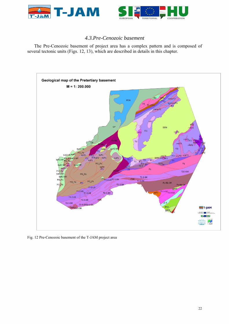
4.3.Pre-Cenozoic basement
The Pre-Cenozoic basement of project area has a complex pattern and is composed of several tectonic units (Figs. 12, 13), which are described in details in this chapter.
Fig. 12 Pre-Cenozoic basement of the T-JAM project area
22

Fig. 13 Relief map of the Pre-Cenozoic basement of the T-JAM project area
4.3.1. The Penninic
The Penninic outcrops form the basement, at the NW part of the area. Lithologically the Penninic Unit consists of Mesozoic detrital rocks metamorphosed in greenschist facies evolved from basic volcanites (quartzphyllite, calcareous phyllite, meta-conglomerate and different greenschists) that can be examined directly in surface exposures in the Kőszeg Hills. The age of the original rocks is Jurassic or Early Cretaceous (CSÁSZÁR 1997). The metamorphosis took place during the Eocene and Oligocene, while the uplift, associated to the cooling of the unit, occured during the Miocene (BALOGH et al. 1983, DUNKL & DEMÉNY 1997).
4.3.2. The Graz Paleozoic and the Ikervár Unit
S and SE of the Penninic Unit low-grade metamorphic rocks (the so-called Rába Metamorphic Sequence, FÜLÖP, 1990) that correlate with the Graz Paleozoic are known from the deep drillings from Szentgotthárd through the Ölbő area as far as the NNE margin of the Mihályi ridge. Further southward towards Slovenia it probably occurs in the basement along a narrow stripe near the Austrian border. The succession reached by the deep drillings on the Mihályi ridge and its surroundings was interpreted as the result of an Early Paleozoic (Silurian?–Devonian) sedimentary cycle by FÜLÖP (1990) who considered the Nemeskolta Sandstone as the basal unit of the cycle, then different phyllites (Mihályi Phyllite) would follow with volcanic intercalations (Sótony Metavolcanite) and Devonian carbonate (Bük Dolomite) closes the sequence. The carbonaceous deposition becomes more significant upwards in the sequence. The correlation of the schist at Szentgotthárd with the Mihályi Phyllite is uncertain, so they are treated separately. Part of these rocks can be attributed to the Lower Paleozoic rocks of the Transdanubian Range, and they have Paleozoic K-Ar ages around 315 Ma (ÁRKAI & BALOGH 1989). On the other hand, schist of Szentgotthárd, and the phyllite of Mihályi show K-Ar ages of 180 to 116 Ma (ÁRKAI & BALOGH 1989). This refers
23

to the effect of the Alpine orogeny in the discussed rocks, thus the K-Ar data can be interpreted as mixed ages that partly became rejuvenated (ÁRKAI & BALOGH 1989). Among others, this makes it possible to distinguish these rocks from the very similar low-grade metamorphites of the Transdanubian Range Unit.
In a few boreholes, the metasediments contain fossils (Lombardia?, Tintinnida?, Echinodermata?) which might suggest Late Juassic?–Early Cretaceous? depositional age (JUHÁSZ & KŐHÁTI 1966). Although this paleontological result was not confirmed, HAAS et al. (2010) figured a small unit composed of late Mesozoic metasediments, the Ikervár unit. Its structural position is probably between the Graz Paleozoic and Transdanubian Range units.
4.3.3. The Koralpe-Pohorje-Wölz Unit and derived mylonites
SW from the Bajánsenye–M–1 (B–M–1) borehole, the basement is composed of rocks that suffered Eoalpine (Cretaceous) metamorphosis; they are mainly gneiss and mica schist, less frequently amphibolite (rarely eclogite) and occasionaly marble and quartzite (LELKES-FELVÁRI et al. 2002). These rocks are correlated with the crystalline rocks of the Koralpe-Pohorje-Wölz nappe. They are in tectonic contact with the Mesozoic rocks of the Transdanubian Range Unit (FODOR et al. 2003, HAAS et al. 2010).
Near the contact of non-metamorphosed rocks, the metamorphites appear in a tectonic window below the non-metamorphic rocks. The Koralpe-Pohorje-Wölz Unit was severly deformed, and transposed to mylonites. In Hungary the temporally name for these mylonites is the Baján Fm. Ar-Ar ages suggest late Upper Cretaceous age for the formation of white micas. However, later reactivation in ductile or in brittle regime (cataclasite) is possible as judging from the outcrops in the Pohorje Mts. The deformation of the rocks might have lasted until the end of Early Miocene.
The Austroalpine rocks in Slovenia are broadly divided into two main groups, comprising the rocks crystallized in the almandine-amphibolite facies (the Lower Austroalpine unit) and the rocks of the greenschist facies (the Upper Austroalpine unit). More than 200 boreholes were drilled in the Slovenian part of the project area, though most of them did not reach the pre-Cenozoic basement. The following boreholes reached metamorphic basement: Ba-1/57 to Ba-5/58; BS-2/76; Dan-1/78; Dok-1/88; Fi-1/54 to Fi-9/56; Fi-11/57 to Fi-19/58; GB-1/87; Kor-1αg/08, Lipa-1/86; Ljut-1/88; Lo-1/58; Mb-1/90 to Mb-6/94; Mot-1/76; MS-1/43 to MS-4/67; Mt-1/60 to Mt-3/61; Niko-1/08; Nu-4 and Nu-6/68; Pan-1/76; Peč-1/91; Rak-1/86; SG-1/54; St-1/82; Šal-2/79; Šom-1/88; T-1/69; T-4/87; T-5/03; V42; V49, Ve-1/57 and Ve-2/57. Most of them ended in the Koralpe-Pohorje-Wölz Unit, representing high to medium grade polymetamorphosed rocks with strong Alpine metamorphic overprint, documented by mineral composition and age (FODOR et al. 2008, JANÁK et al. 2006). They usually show pronounced mylonitization and stretching lineation.
4.3.3.1. The Upper Austroalpine unit; the Kobansko and Magdalensberg Formations
The rocks of the greenschist facies occur in Slovenia only. The rocks of the greenschist facies (sensu stricto) are developed subordinately and comprise chlorite amphibole schists (with biotite, epidote and albitic oligoclase) joined on the basement map with sericite-quartz phyllites, as Kobansko Formation. Characteristic rocks of the phyllitic part of succession are metakeratophyre, its tuff and marble with tuffaceous and sericite-chlorite admixture.
Phyllitoid rocks in the environ of Sotina at Goričko, represent sericite phyllite with transitions to carbonate phyllite and chlorite phyllite. Marble and graphite quartzite are less frequent (PLENIČAR, 1970 a, b). Their lithological appearance (metatuffites) is similar to the
24

upper part of the Magdalensberg Formation, but due to the compilation with the bordering region toward Hungary and Austria, they are described as Variscan low grade metamorphic Lower Paleozoic formation of the Upper Austroalpine Unit. The only appearance of the Magdalensberg Formation slates (very low grade metamorphic pelagic sediments) is reached by Šom-1/88 borehole in the north-western part of the basement map.
4.3.3.2. The Lower Austroalpine unit; the Pohorje Formation
The second group of metamorphic rocks in Slovenia comprise gneisses and micaschists with lenses of amphibolites, eclogite and subordinately of quartzite and marble. These rocks represent the prevailing lithology of the Pohorje Formation.
Pohorje Formation represents direct continuation of the Middle and Upper Austroalpine rocks towards the East. On the T-JAM project area they are completely covered with 500 to up to 5500 m thick Neogene rock sequence. The rocks are regionally polymetamorphosed with strong Alpine metamorphic overprint. Traces of older rocks were detected only by isotopic radiometric dating on zircon (FODOR et al. 2008).
Mylonitization of variable intensity affected the majority of the Pohorje and Kobansko metamorphic rocks succession and by analogy with, and based on the data from some of the boreholes, the pre-Cenozoic metamorphic basement as well. In cases of stronger mylonitisation, particularly in phyllonitized zones, problem of adequate lithological determination (particularly of rock chippings) arises. The contact rocks between the Pohorje and the Magdalensberg Fm. are partly determined as phyllites with thrust boundary, partly as phyllites with gradual transition to gneisses and micaschists and partly as retrogressive rocks comprising several rock types. In geological interpretation of the basement, these rocks were joined into the group of mylonites and phyllonites, as for the moment, more strict determination is not possible.
4.3.4. The Transdanubian Range Unit, Magmatic-metamorphic zone
Mainly Early Paleozoic epimetamorphic rocks of sedimentary, siliciclastic origin (Balatonfőkajár Quartzphyllite) can be found in a zone bordered by the Balatonfő- and the Balaton Lines (within the Balaton Zone). Several boreholes in the Zala Basin (e.g. Pördefölde Pd–1, Eperjehegyhát E–6, Pusztamagyaród Pu–5, Gelse Gel–1), however, reached through lower-grade (anchimetamorphic) silt- and sandstone slate. At the same time, other boreholes (Balatonhídvég Hi–1, Hi–2, Sávoly Sáv–7, Garabonc Gar–1) drilled through rocks of much higher metamorphic grade (garnetic mica schist, andalusite-biotite-sillimanite schist). The relations among these rocks and the age of the metamorphism are not understood yet. According to FÜLÖP (1990) the metamorphic grade of the Balatonfőkajár Quartzphyllite increases towards SW; he explains the appearance of higher-grade metamorphic rocks around Balatonhídvég, Sávoly and Garabonc with their spatial distribution. However, this does not give any explanation for the position of the low-grade metamorphic rocks that occur in the continuation of the zone in the Zala Basin. But these metamorphites of rather different metamorphic grades along the Balaton Line can be well interpreted structurally as the continuation of the Periadriatic strike-slip lineament (KÁZMÉR & KOVÁCS 1985, BALLA 1988, TARI 1994, FODOR et al. 1998) and the rocks of various metamorphic grade within the zone can be explained as tectonic fragments deriving partly from the Transdanubian Range Unit, partly from a not precisely identified (Austroalpine?) unit.
25

4.3.5. The Transdanubian Range Unit
The major part of the area belongs to the Transdanubian Range Unit, whose Pre-Cenozoic basement consists of sedimentary rocks. The Pre-Cenozoic rocks are exposed on surface in the Transdanubian Range, while south-westwardly they represent the basement of the Zala Basin. The Pre-Cenozoic basement crops out only in the Keszthely Hills and around Sümeg in the project area. The oldest member of the succession is the anchimetamorphic Early Paleozoic (Ordovician–Devonian) open-marine slate (Lovas Fm., FÜLÖP 1990, BUDAI et al. 1999), which is covered with Late Permian–Early Cretaceous more or less continuous sedimentary sequence following a considerable hiatus. The sequence deposited in this stage of the Alpine cycle was deformed by the Austrian compressional phase in the middle Cretaceous. The compression resulted in folding and even a few hundred-metre wide reverse fault zones in the limbs of the evolving syncline (Litér line, Veszprém line). Jurassic and Early Cretaceous rocks were preserved only along the axis of the syncline during the uplift that followed the deformation, while even the Triassic rocks were mostly eroded in the limbs of the syncline. The Late Cretaceous sediments were deposited on this deformed and eroded surface with considerable hiatus.
A characteristic Late Permian deposit of the Transdanubian Range is the continental detrital sandstone (Balatonfelvidék Sandstone), which — together with the Early and Middle Triassic rocks — is known in the SE and NW limbs of the syncline. However, the presence of the Early Permian rhyolite (Kékkút Rhyolite) cannot be outruled either, since several boreholes exposed it in the basement of the Tapolca Basin, close to the project area, e.g. Gyulakeszi Gy–5, Káptalantóti Kt–3 and Badacsonyörs Bö–12 boreholes (FÜLÖP 1990). The Late Permian sandstone, reached in the project area on the north side of the Balaton Zone by Dióskál Di–5 borehole, is repeated several times in an imbricate together with Early Triassic rocks (KŐRÖSSY 1988). The Early Triassic shallow marine succession was also reached by Szigliget Szi–1 borehole (BUDAI et al. 1999), its lower part (Induan stage) is anhydrite-dolomite and sandstone (Köveskál Fm), its upper part (Olenekian stage) is red silt and cellular dolomite (Hidegkút Fm) then marl and limestone (Csopak Marl).
The lowest Middle Triassic (lower Anisian) is composed of shallow marine carbonates: finely laminated cellular dolomite (Aszófő Fm) at the base, then laminar bituminous limestone (Iszkahegy Fm), then again dolomite at the top (Megyehegy Fm). The same Early–Middle Triassic sequence is known in the NW limb of the syncline from the Alsószalmavár Asz–1 borehole drilled on the margin of the Little Hungarian Plain (HAAS et al. 1988). The sedimentary rocks of middle to upper Anisian,, and Ladinian stages are composed mainly of marine limestone, marl, tuffite and siliceous sediments (Felsőörs Fm, Buchenstein Fm) e.g. in Ortaháza–7, –9, –34; Kehida–3; Bajcsa–I, –14; and Pusztaapáti–1 boreholes.
The lowest part of the Late Triassic (Carnian stage) is composed of intraplatform basin marl and calcareous marl (Veszprém Fm) with limestone intercalations in its upper part (Sándorhegy Fm). Carnian basin deposits are known also on the surface in the Keszthely Hills, where they interfinger with shallow marine platform carbonates (Ederics Limestone and Sédvölgy Dolomite) (BUDAI et al. 1999). Carnian basin sediments were drilled by Hévíz–6, Dióskál–7, Pötréte–1, Kehida Kd–3 and Nagytilaj–2 boreholes, as well as several boreholes around Nagylengyel and Ortaháza (KŐRÖSSY 1988). The upper part of the Late Triassic (Norian–Rhaetian) is represented by widespread thick shallow marine carbonates. The lower, approximately 1.5 km thick deposit is dolomite (Hauptdolomit), the upper few hundred metres is Dachstein limestone. The Norian dolomite crops out in the Keszthely Hills, while limestone is found only in the vicinity of Sümeg. Norian–Rhaetian intraplatform basin deposits are also known in the most part of the project area: The lower part is bituminous
26

laminar dolomite (Rezi Dolomite), and the upper part belongs to marl and clayey marl (Kössen Fm). The Norian–Rhaetian deposits are also known on the surface in the Keszthely Hills (BUDAI et al. 1999) and around Sümeg too (HAAS et al. 1984) and were also rached by several boreholes in the basement of the Zala Basin, e.g. around Nagytilaj, Zalaszentmihály, Szilvágy, Kehida, Nagylengyel, Misefa and Pölöske (KŐRÖSSY 1988).
Jurassic–Early Cretaceous rocks are known on the surface only near Sümeg in the project area. Here the early Jurassic is represented by shallow marine limestones (Kardosrét, Pisznice and Hierlatz Limestone), the Middle –Late Jurassic by pelagic basin limestone of the ammonitico rosso type, and radiolarite (Lókút Fm) (HAAS et al. 1984). The Latest Jurassic–Early Cretaceous cherty biancone type limestone (Mogyorósdomb Limestone) is followed by pelagic Early Cretaceous marl (Sümeg Marl). The Jurassic–Early Cretaceous rocks of different facies are preserved in small erosional patches in the basement of the Zala Basin, e.g. in boreholes around Nagylengyel–Pölöske–Misefa–Nagytilaj–Szilvágy and Hahót. The Aptian–Albian Limestones are preserved on the surface around Sümeg (Tata Limestone) and reached by boreholes around Nagylengyel.
The Late Cretaceous sedimentary rocks were deposited uncomformably on the folded, uplifted and eroded Pre-Senonian basement. The basement was uplifted and deformed during the Austrian phase (HAAS et al. 1984). The continental erosional period was characterized by the karstification of the surface that built up mainly of Triassic carbonate and bauxitization (around Sümeg). The Late Cretaceous rocks are represented by shallow marine reef limestones with Rudists (Ugod Limestone) in the Pre-Senonian areas, while in the basin pelagic marl sequences dominate (Jákó and Polány Marl). Senonian deposits are widespread in the basement of the Zala Basin and the Little Hungarian Plain.
In Slovenian part of the project area, rocks similar to the Transdanubian Range unit occur only in very small tectonic or erosional remnants. Upper Triassic and Cretaceous tectonic lenses of carbonate rocks and Gossau clastic rocks are interpreted to be tectonicaly extruded, mostly within strike-slip structures of the Radgona-Vas fault zone, at the northern edge of the Murska Sobota Massif.
4.3.5.1. The Ljutomer Belt
Southern part of the Slovenian project area differs considerably from the Koralpe-Pohorje-Wölz unit, so from lithological, as from structural point of view. Within the E-W trending Ljutomer Fault zone Upper Paleozoic to Mesozoic formations and Lower Triassic, prevailingly clastic rocks of the Transdanubian range are interpreted (as compared to the units in continuation to the Hungarian side). No direct data from the boreholes confirm their existance, as none of them reached the pre-Cenozoic basement. The Ljutomer belt is supposed to be bounded by reverse fault toward the Murska Sobota block as well as toward southerly situated carbonate rocks of the Southern Karavanke zone. The faults within the Ljutomer Fault zone are roughly accepted from the structural model of JELEN & RIFELJ (2009-2010). This zone was interpreted as Northern Karavanke zone of HAAS et al (2000). The Ljutomer fault zone itself could represent the prolongation of the Periadriatic zone (e.g. PLACER 2008).
4.3.6. The Mid-Transdanubian Unit
The basement between the Balaton Zone and Mid-Hungarian Line is known only from deep boreholes, and is attributed to the so-called Mid-Transdanubian composite unit (HAAS et al. 2000, 2010). It is build of Permo-Mesozoic rocks. Together with the southern Magmatic-metamorphic Zone of the Transdanubian Range Unit these rocks build up the Mid-Hungarian shear zone. The unit can be further divided into three parts (HAAS et al. 2000): the Julian–
27

South Karavanke, the South Zala and the Kalnik subunits. Although they are structurally connected, the character and age of the structural relationship is known with certainty. In the northern and southern parts of the project area, near the Hungarian/Slovenian border Permian shallow water, siliciclastic and carbonaceous sedimentary rocks are known (South Karavanke Subunit). The dark grey sericite schist underlying the Early Permian limestone in the Újfalu–1 (U–1) borehole is interpreted as Carboniferous.
In Slovenia, the Southern Karavanke Paleozoic to Mesozoic formations are found south of the Ljutomer zone (Periadriatic zone), in tectonic contact with the transitional Ljutomer belt. Only the DS-1/58 borehole reached Middle to upper Triassic carbonate rocks in this belt in Slovenia. Three more point data are available from the Croatian side of the area (Vuč-1 and 2, Vuk-1 boreholes) near Vučkovec and Vukanovec. Therefore, the basement map south of the Ljutomer zone is mostly a matter of interpretation.
In the southern part of the area (South Zala subunit) the Permian evaporite-bearing deposits are probably covered by Triassic carbonates and Triassic–Jurassic slope- and basin deposits that suffered very low-grade metamorphosis. In the Kalnik subunit a Cretaceous(?) melange (Inke Fm.) is covered by the Late Cretaceous (Senonian) pelagic marl (Gyékényes Fm.).
4.3.7. The Tisza Unit
In a very small area at the southwesternmost part of the project area the Pre-Cenozoic basement is composed of the medium-grade metamorphic crystalline schists of the Tisza Unit. The Mid-Transdanubian Unit is probably thursted upon the Tisza Unit to some extent (CSONTOS & NAGYMAROSY 1998).
4.4. Eocene
Eocene formations in the Zala region (Hungarian part of the project area) have been known only from the Bak-Nova Trough of E–W strike, as well as in the vicinity of Ortaháza in a sliver. They unconformably overlie Upper Cretaceous and Triassic formations. The Bak–Nova Trough was formed as a result of compression, somewhat S of the axis of the Late Cretaceous sedimentary basin, where the Upper Cretaceous–Eocene sediments were folded into a syncline with steep limbs on both sides.
In the Sávoly area, in the zone of the Balaton Line, new Eocene occurrences became known as a result of the explorations of the Hungarian Oil and Gas Company (MOL) (JÓSVAI et al. 2005). The several-hundred-metre-thick Upper Eocene succession comprises dark grey and black claystones of fresh-water facies, which contain Ostracods, and locally rich in coalified plant remains and coal stringers.
In the area of the ALCAPA tectonic unit volcanism — which can be traced from the Southern Alps up to the North-Hungarian Range — commenced in the late Middle Eocene, and culminated during the Oligocene. Magmatic centres can be detected from the Zala area to the Mátra Mountains, in a zone of WSW–ENE direction. In the Zala area volcanics of andesitic–dacitic composition (Szentmihály Andesite Formation) — characterized by great thicknesses — are known from deep wells; they may penetrate the Szőc Limestone and the Padrag Marl, as well. It is to note that the age of this volcanic suite was questioned during the last years, and it was interpreted as shallow intrusions of Oligocene age, temporally connected to tonalite intrusions (BENEDEK et al. 2001).
28

In the Slovenian part of the project area Eocene deposits do not crop out. They are only presented in the P8 geologic cross section (Appendix IV) as frequent alteration of the marl and limestone, occasionally carbonate breccia.
4.5. Oligocene
Oligocene was characterized by a continental sedimentation in the northern part of the Zala region and in the marginal areas of the Transdanubian Range. The material of the continental-fluvial succession, classified into the Csatka Formation, was deposited by a river (as big as the present Rába river) (BENEDEK et al. 2001). In the Zala area course-grained sediments are predominant. The source area of the material can be traced SW of the Transdanubian Range, however, transportation with less capacity may have taken place from the S, as well. In the northeastern part of the study area a fluvial sequence of SSW–NNE direction can be contoured (below the Pusztamiske depression?).
Along the Balaton Zone, intrusions came into being during the Oligocene. Toward the W these tonalithic bodies can be correlated with magmatic bodies located along the Periadriatic Line, since they are very similar both in age (30–32 Ma) and geochemical character (BENEDEK 2002).
Oligocene sedimentary rocks are present in the south-westernmost part of the Slovene territory involved in the project (JELEN & RIFELJ, 2011). Two formations of Oligocene age are present in the Ljutomer Belt just north of the Donat fault. Pletovarje formation consists of sandy marl and rarely sandstone. Govce formation involves quartz sandstone and conglomerate, and glauconitic sandstone. The age of the Pletovarje formation is Upper Oligocene (Lower Egerian), while the Govce formation may range from Upper Oligocene to – Lower Miocene. The odd geometry of the stratigraphic units presented in the southernmost part of the P8 geologic cross-section (Appendix IV), most probably reflects tectonic lenses in the Donat fault zone.
4.6. Pre-Pannonian Miocene
4.6.1. Eggenburgian–Ottnangian
During the Eggenburgian and Ottnangian the study area was characterized by continental sedimentation. In the southern region a succession made up of conglomerate, gravel, sandstone, silt and clay and belonging to the Szászvár Formation was deposited. It was penetrated by boreholes in the vicinity of Lenti (Csesztreg, Kerkabarabás and S/SE of Nagykanizsa (Zákány, Porrogszentkirály, Iharos, Inke). It unconformably overlies the Mesozoic basement, and is unconformably overlain by the Budafa, Tekeres, Lajta or younger ‘Pannonian’ formations. Locally, the thickness of the Szászvár Formation exceeds 1000 m (Gyékényes Porrogszentkirály Gyék–I borehole). Locally tuff interbeddings (“lower rhyolite tuff”/Gyulakeszi Rhyolite Tuff Formation) could be found in the continental succession (Kerkabarabás, Inke, Iharos area).
In the western foreland of the Transdanubian Range the Lower Miocene is represented by the terrigenous Somlóvásárhely Formation of Eggenburgian-Ottnangian and Karpatian age, which can be distinguished from older continental successions (Csatka Formation) only with difficulties, and its areal delineation is also problematic. Its maximum thickness is 129 m (Nagygörbő Ng-1 borehole), in which intercalations of the ‘lower rhyolite tuff’ (Gyulakeszi Formation) can also be observed.
29

Lower Miocene continental deposits of the northwestern part of the study area (in the vicinity of Szombathely and Szentgotthárd) are classified into the Ligeterdő Formation (Auwaldschotter), which passes up to the Karpatian. Its material is derived from rocks of the Eastern Alps; debris was transported into the western Hungarian sedimentary basins by rivers. The formation overlies the Mesozoic basement. In the Szombathely–II borehole there is a tectonic contact between the Ligeterdő Formation and the Mesozoic basement. It is overlaid by the Badenian formations. In the study area the thickness of the Ligeterdő Formation is of some tens of metres. The age of the formation was formerly infered as Ottnangian and Karpatian, but based on data from Austria (PASCHER 1991), its age should be revised to the Early Badenian.
Some boreholes of the study area penetrated volcanics, such as the Mecsek Andesite Formation (in the vicinity of Sávoly) and the Gyulakeszi Rhyolite Tuff (‘lower rhyolite tuff’). The latter occurs in connection with the Lower Miocene continental successions.
4.6.2. Karpatian–Lower Badenian
In the Hungarian part of the project area Karpatian–Lower Badenian sediments are bordered by the Rába Line on the north, on the E by the scarp fault zone of the Mesozoic up to the Balaton Line, from which they extend towards the S and the E. Their southern border is the Somogyudvarhely-Szigetvár tectonic line. The thickness of the successions is uncertain, since most of the boreholes have not transected it. The maximum thickness in the Őrség–Lovászi deep zone (L-II) is 2000 m. Sedimentation took place in the Őrség-Lovászi-Budafa-Oltárc area, which was an inlet with marine connections towards the W.
The denudation terrain was predominantly made up of Mesozoic carbonates and pelitic sediments (in the western part of the Őrség, moreover of Palaeozoic rocks along the Balaton Line); disintegration of these rocks took place within relatively short distances. This may be the reason why — not far from the one-time shorelines —, exclusively pelitic sediments can be found. The sedimentary basin did not occupy a large area, the thick pelitic sedimentary succession does not refer to a deep basin, but it indicates that sedimentation kept pace with the sinking of the basin floor.
To sum up: marine characteristics increase from the SW towards the NE. In the Karpatian, coarse-grained facies is predominant only along a narrow strip at the marginal zone; the internal part of the sedimentary basin is predominated by thick pelitic successions. Sedimentation of the eroded material derived from the margins kept pace with the rapid sinking; therefore sedimentation took place all the time in a shallow-marine environment. Facies characteristics were determined by the restriction of the sub-basins from the sea, the decrease of salinity due to the rivers carrying freshwater into the depressions, and the degree of subsidence and filling up.
Due to the same lithologic characteristics, Karpatian sediments can hardly be distinguished from Badenian ones. Karpatian rocks are predominated by brackish-water fauna, showing a gradual transition into the Badenian, in which it is still not diverse. The significant change happens within the Badenian, with the appearance of a rich marine fauna; simultaneously, this horizon represents the boundary of the sedimentary cycle.
In the Slovenian part of the project area Karpatian to Lower Badenian deposits belong to the Haloze Formation. According to JELEN & RIFELJ (2005c, 2006), sedimentation of the Haloze Formation represents the sedimentary infill of the “core complex” stage that lasted from the Late Ottnangian to the Karpatian as a part of the first synrift phase.
30
In the Karpatian, sandstone, conglomerate, muddy breccia and conglomerate, oyster banks represent the lowest part of the Haloze Formation in the Maribor sub-basin. Southward, in the Haloze – Ljutomer – Budafa sub-basin sandy and silty marl, alternation of sandy marl, silty marl and sandstone make up the Karpatian and Lower Badenian deposits of the Haloze Formation. Tuff of Early Badenian age also makes a part of the Haloze Formation, as well as questionable assignation of conglomerate and conglomerate with lithothamnian nodules. Alteration of sandstone, sand, sandy marl and conglomerate represent the uppermost part of the Haloze Formation and also belong to the Lower Badenian succession. The Haloze Formation represents the initial infill onto the Pre-Cenozoic basement due to significant subsidence of the area mostly along ENE trending fault systems: the Donat transtensional fault system and the Raba Extensional corridor (JELEN & RIFELJ 2003, 2004, 2005a, b).
Field observations indicated that the Mura–Zala Basin was a turbiditic basin since the beginning (in the Karpatian) until the Early Pontian (JELEN & RIFELJ 2001, 2003). Haloze Formation deposits are present in the westernmost part of the Maribor Sub-Basin and probably in the western part of the Haloze – Ljutomer – Budafa sub-basin. In the central part of the Mura–Zala Basin, on the Murska Sobota block the deposits of the Haloze Formation are missing either due to subsequent erosion, or partly due to absence of the deposition. To the east, they are found in boreholes in the East-Mura – Őrseg sub-basin. The thickness of the Haloze Formation is up to 1300 m in the Maribor sub-basin, and approximately the same thickness is reported to the east, in the Hungarian cross sections.
4.6.3. Badenian
In the Hungarian part of the project area tectonic movements led to regression at the end of the Karpatian and — in the basinal areas — in the lower Badenian. This resulted in the appearance of coal-bearing marsh facies and clastic deposits. The regression was terminated by a new compression phase, leading to further shortening along the main tectonic line of NE–SW direction.. It resulted in the formation of the Lovászi and Budafa–Oltárc anticlines.
This process was followed by a remarkably intense transgression in the Őrség-Lovászi-Budafa-Oltárc area. The entire area of South Transdanubia may have been a shallow archipelago.
In the Őrség-Lovászi-Budafa-Oltárc area there is a transition from the Karpatian into Badenian succession. Eastward, in the area located between the Rába Line and the Salomvár-Hottó-Nagytilaj line, Badenian sediments overlie the eroded surface of the Mesozoic rocks with a considerable hiatus. Badenian sediments overlie the eroded surface of Palaeozoic, Mesozoic and Eocene formations unconformably in the area between the Salomvár-Hottó-Nagytilaj Line and the Balaton line. S of the Balaton Line, Badenian sediments are found above Karpatian, in smaller areas above Mesozoic, Palaeozoic formations and Early Palaeozoic metamorphites
Since Badenian transgression invaded the area from the W–SW, the northeastern uplifted part of the region and the higher parts of the ranges within the basin were not affected by it.
In the northwestern basinal area (Őrség-Lovászi-Budafa-Oltárc) sedimentation was continuous. The dark-grey and brownish-grey marls differ from older ones only due to the tuff interbeddings (tuff strips), and in the appearance of the abundant Badenian faunal elements. During the Badenian this part of the basin remains a rapidly sinking inlet in which sedimentation keeps pace with subsidence. Sedimentation is predominated by pelitic deposits.
31

At the end of the Badenian a barrier came into being again. The barrier isolated the area from the open sea, and an epicontinental sea of decreasing salinity evolved by the Sarmatian. This regressive process is indicated by the increasing number of sandstone beds.
In the Slovenian part of the project area a sedimentary infill of the wide rift stage took place as a second part of the first synrift phase. Tectonic uplift and synchronous eustatic sea level drop at the Karpatian/Badenian boundary resulted in the erosional unconformity in the shallow parts, and fans of coarse grained deposits in the deeper parts of the sub-basins. In the deepest parts of the basins a “starving basin” condition evolved. The sudden tectonic uplift and eustatic sea level drop was followed by a very rapid subsidence accompanied by an Early Badenian transgression (JELEN & RIFELJ, 2001, 2004, 2005a, b). For this reason the Lower Badenian sedimentary rocks onlap also onto the Pre-Tertiary (Pre-Paleogene) basement of the relatively uplifted tectonic blocks. Deep water conditions evolved over transgressive biostromes of the algal limestones and fans. Mud rich turbidites and hemipelagic mud began to fill up the lowest parts of the basins due to intense subsidence and sea level rise.
An extensional collapse provoked the postrift subsidence of the tectonic blocks including the highest areas. The extensional collapse and the almost synchronous onset of compression in the Alps (MASSARI et al. 1986) initiated a change in the sedimentation to sand rich turbidites. These sand rich turbidites are proximally prevailing, while in the distal parts the change is marked by a progradation in the Upper Badenian. In the deepest parts of the sub-basins the change is marked in the falling stage system tract (FSST).
An unconformity follows in the shallow parts of the sub-basins in the LST period near the Badenian/Sarmatian boundary. Subsequently, in the deeper parts of the sub-basins the correlative normal sequence boundary moves towards the sand richer turbidite fans.
4.6.4. Sarmatian
In the Hungarian part of the project area Sarmatian basically has a regressive character, but due to the different movements of the basin floor, locally it shows transgressive features. It is characterized by brackish-water formations.
In the northwestern part of the basin (Őrség, Lovászi, Budafa) and in the adjacent eastern margin (Szilvágy, Barabásszeg, Nagylengyel, Bak, Nova) it shows continuous transition from the Badenian, and — compared to the latter — it shows regressive characteristics. In the centre of the basin it is predominated by sandy beds. At this time — due to the former uplifting (i.e. upwarping of the Budafa–Lovászi area), the deepest part of the basin was located in the Szentgyörgyvölgy, Kerkáskápolna, Őriszentpéter, Kotormány region, where coarse-grained sandstone was formed, locally with small-sized pebbles. These features do not indicate the proximity of the shore, but sediment transport from the margins, and gravitational re-deposition on the slopes. This material can be accumulated in the deepest parts. Southwards, clastic sediments become finer; in the Lovászi and Budafa area pelites and silts are predominant.
In the marginal areas the thicknesses of the Sarmatian beds decrease and become more marly, and characterized by a pinching out against the Badenian tectonic highs. In the basin and in the marginal areas the Sarmatian is conformably overlain by the lower Pannonian. Coarse-clastic, biogenic limestone facies of the Sarmatian can be found in areas, which were in the highest position during the Badenian, and were affected by transgression only at the end of the Badenian.
32

By the end of the Badenian connection towards the open sea became narrower, salinity of the sea decreased. Connections towards the Mediterranean ceased, brackish-water sediments were deposited. The thickness of the Sarmatian ranges between 100 m and 200 m in the basin, whereas on the elevated highs their thickness does not exceed some tens of metres.
For the hydrogeological model it was important to give the bottom contour of the Sarmatian and Badenian marine deposits, which overlie the pre-Badenian Miocene and Oligocene fluvial deposits, as well as the distribution of the Tinnye and Lajta Formations (Sarmatian and Badenian detrital limestones) as they are hydrodynamically significant. This map was edited for the Hungarian part of the project area (Fig. 14).
Fig. 14 Bottom contour map of the Sarmatian and Badenian marine deposits. Grey: Sarmatian detrital limestone (Tinnye Formation), white: Badenian detrital and algal limestone (Lajta Formation)
In the Slovenian part of the project area heterolitic siliciclastic sediments and carbonates were deposited during the transgressive system tract (TST) of the Early Sarmatian in the shallow parts of the Mura-Zala Basin, while turbiditic sedimentation persisted in the deeper parts of the sub-basins still as a part of the sedimentary infill of the first post-rift phase.
33

A weak kinematic inversion in the Mura-Zala Basin, as a part of the ALCAPA lithospheric block, took place during the Late Sarmatian, due to completed collision with the Eastern European lithospheric platform. Inverted structures such as “Pečarovci” and “Dankovci” formed as a result of the change in the behaviour of the faults, and increase of the coarse grained deposits folowed consequently (cf. SADNIKAR 1993, Fig. 8; GOSAR 2005, Fig. 6).
The Maribor sub-basin, the western part of the Radgona – Vas sub-basin and the western part of the Haloze – Ljutomer – Budafa sub-basin were filled up by the end of Sarmatian, and acted as a by-pass zone for the sediments since the Pannonian transgression.
The described (Badenian and) Sarmatian deposits, together with the Badenian ones as a sedimentary infill of the wide rift and the first post rift phase were defined as Špilje Formation by JELEN & RIFELJ (2005d).
4.7. ’Pannonian’
When talking about ‘Pannonian’ sediments we have to make a difference between facies of the basins (i.e. the predominant part of the T-JAM area, i.e. the Zala-Mura Basin and the southern part of the Little Hungarian Plain) and the marginal areas at the foot of the mountain ranges.
The base of the ‘Pannonian’ formations was edited for the entire Hungarian and for the E-ern part of the Slovenian project area (Fig. 15).
Fig. 15 Depth of the base of the ‘Pannonian’ formations (depth below sea levels in metres)
34

In the Hungarian part of the project area Lower ‘Pannonian’ formations transgressively overlie the older rocks. In most part of the area (except for uplifted blocks covered with Badenian leithakalk at the very beginning of the Pannonian) continuous sedimentation took place at the Sarmatian–Pannonian boundary. This boundary can be drawn within pelitic, fossil-poor sediments (Kozárd and Endrőd Fm), therefore the boundary cannot be clearly marked. Horizons mentioned as “Pannonian base” in the well documentations were proved to be of different ages. For fixing the exact boundary macrofauna descriptions should be needed from the boreholes; such data are seldom available, moreover these data — in many cases — are available from areas characterized by interrupted sedimentation.
Thus, Lower Pannonian in the basins usually starts with marls and calcareous marls belonging to the Endrőd Formation. Its characteristic thickness ranges from 100 to 400 m, above the marginal zones and certain uplifted ridges (such as the Belezna anticline in the southern part of the area) it is thinner. In the study area basal conglomerate — made up of the material of the inundated basement — seldom occur at the Pannonian base, and characterized by a thickness of some metres (Békés Conglomerate).
The marl succession is overlain by the turbidites of the 100–150-metre-thick Szolnok Formation, which comprise sand bodies embedded in pelite and of a thickness of some meters or some tens of meters. We may reckon with maximum thicknesses in the surroundings of Csesznek and Resznek, as well as on the southern limb of the Budafa anticline and in the trough located S of the latter (Fig. 16.). Based on the evaluation of wire-line logs of 100 wells carried out with 1 m resolution it can be stated that the proportion of and is likely to be smaller above areas characterized by uplifted basin floors (Belezna, Budafa, Ortaháza and the marginal zone of the Transdanubian Range), than that of areas above troughs. Percentages of sand range from 25 to 50 per cent above ridges, whereas the total percentage of sand in troughs ranges from 50 to 70 per cent (Fig. 17.). The only exception is the low percentage of sand in the Szilvágy depression — contrary to the high percentages derived from the Nagylengyel High area E of it. Sand bodies of the Szolnok Formation were formed as a result of discrete turbidity events; during the long intervening time intervals pelitic deposition took place. Thus, the connection between the sand bodies is rather limited.
Some parts of the Zala Basin are characterized by the following: prior to the deposition of the main bulk of the Szolnok Formation, a thin turbidity sequence appears (with an average thickness of 50-100 m, exceptionally of 200-400 m in the Lovászi area). In most parts of the area, above it, the Endrőd Formation temporarily appears again; nevertheless, in certain —very deep — parts of the basin deposits of the latter pass into the main turbidite unit uninterruptedly. The so-called ‘lower turbidite’ occurs in a well-delineated area (Fig. 18.); based on seismic correlation analysis it cannot be connected to one single event; it becomes increasingly younger from the NW towards the SE. Boundaries between all other ‘Pannonian’ formations of the deep basins become younger and younger in the same direction, however, this phenomenon is associated with the filling up of the one-time Lake Pannon, which occurred from NNW towards SSE. (This is the reason why boundaries of formations— which can be drawn in the seismic image — usually intersect seismic reflections interpreted as time horizons.) This type of investigation (separation of ‘upper’ and ‘lower’ turbiditic horizons) was performed only for the Hungarian part of the project area, as the lack of sufficient seismic data did not allow such analyses in Slovenia.
35

Fig. 16. Thickness of the Szolnok / Lower Lendava Formation in meters
Fig. 17 Sand content of the Szolnok formation in the Hungarian part of the project area in per cent calculated from boreholes depicted on the map
36
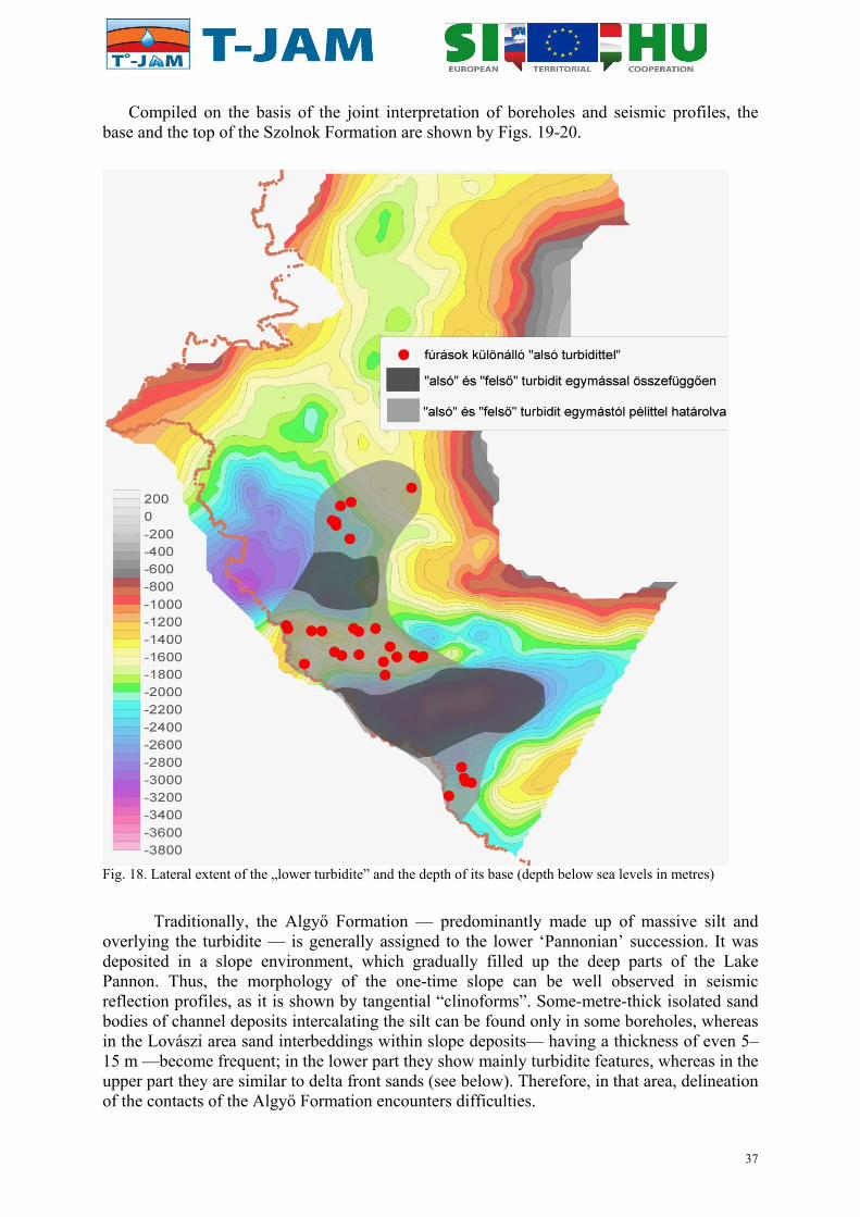
Compiled on the basis of the joint interpretation of boreholes and seismic profiles, the base and the top of the Szolnok Formation are shown by Figs. 19-20.
Fig. 18. Lateral extent of the „lower turbidite” and the depth of its base (depth below sea levels in metres)
Traditionally, the Algyő Formation — predominantly made up of massive silt and overlying the turbidite — is generally assigned to the lower ‘Pannonian’ succession. It was deposited in a slope environment, which gradually filled up the deep parts of the Lake Pannon. Thus, the morphology of the one-time slope can be well observed in seismic reflection profiles, as it is shown by tangential “clinoforms”. Some-metre-thick isolated sand bodies of channel deposits intercalating the silt can be found only in some boreholes, whereas in the Lovászi area sand interbeddings within slope deposits— having a thickness of even 5–15 m —become frequent; in the lower part they show mainly turbidite features, whereas in the upper part they are similar to delta front sands (see below). Therefore, in that area, delineation of the contacts of the Algyő Formation encounters difficulties.
37

Fig. 19 Map showing the base of the Szolnok / Lower Lendava formation (turbidites) (depth below sea levels in metres)
Fig. 20. Map showing the top of the Szolnok / Lower Lendava Formation (turbidites) (depth below sea level, in metres)
38

Slope sediments are overlain by shallow-water deposits, which belong to the upper ‘Pannonian’ sequence (according to the traditional classification). The overlying succession is made up of the alternation of pelitic sediments of a thickness of some hundreds of meters with coarsening-upward sand bodies, the thickness of which ranges from some meters to some tens of meters. These sand bodies were deposited in the one-time delta fronts. The sand bodies are of a considerable lateral extent (they can be traced even for some tens of kilometers). They are in connection with each other, consequently, they are significant as fluid reservoirs: the so-called “thermal water horizon” is built up of these rocks. According to the official lithostratigraphic classification this horizon corresponds with the lower part of the Újfalu Formation, albeit in this work the ‘Újfalu Formation’ is used in a strict sense, for the designation of sediments of the delta front (i.e. the ‘thermal water horizon’).
As this unit is the primary target for the hydrogeological and geothermal modeling of the T-JAM project, the base and top of the delta-front sediments was edited for the entire Slovenian and Hungarian parts (Figs. 21–22).
ű Fig. 21. Depth of base of delta front sediments (base of the Újfalu / Lower Mura Formation) in the entire study area (depth below sea level in meters)
The upper part of the classic Újfalu Formation (s.l.) was deposited in a delta plain environment — this part of the succession was considered as Tihany–Somló Formations (undivided) in the course of the re-evaluation of Hungarian borehole data (the reason of this can be read in the introduction of marginal facies). Instead of sand sheets of considerable areal extent, in this case elongated, laterally narrow, fining-upward channel sand-bodies are predominant, which join each other only locally, and which are divided by flood-plain clay and silt. Flood plain was affected by water level fluctuations, therefore the coarsening-upward sand interbeddings are still present here, i.e. the boundary between the successions of the
39

delta front and delta plain usually cannot be clearly determined. In the course of the re-evaluation of borehole successions — upwards from below —, the boundary between these two formations has been drawn at the base of the first-appearing channel sand body. However, there were significant differences between the delta front tops determined in this way — even in boreholes, located close to each other. This can be explained the fact, that in case of a delta plain succession the borehole may be deepened between strip-like channel sand-bodies even along a longer section, instead of transecting them, thus the fining-upward pattern cannot be observed. Taking this possibility into consideration, among the boreholes along the cross-sections providing contradictory information, the horizon was drawn at the deepest “delta front top” in every case.
Fig. 22. Top of the delta front sediments in the entire study area (depth below sea level in meters)
Going upwards in the succession lacustrine influence may cease; reaching the sediments of the alluvial plain exclusively fining-upward channel sand bodies can be found. According to the lithostratigraphic classification these sediments belong to the Zagyva Formation, however, from a lithological and hydrological point of view they are very similar to those of the upper (delta plain) part of the Újfalu Formation. The Zagyva Formation can be identified only sporadically in the uppermost, some-hundred-metre long sections of ‘Pannonian’ successions of the area (prevailingly of the deep parts of the basin). It can be hardly separated from the overlying Hanság Formation, which was also deposited on the alluvial plain, i.e. it is made up of fining-upward channel sand bodies intersected by some-metre-thick or some tens of metre-thick flood plain clay horizons.
Pannonian sediments of the basin margins are significantly different from the above- mentioned succession. Deep-water marls, turbidites and slope sediments (Endrőd, Szolnok and Algyő Formations) are absent here, because turbidity currents and the prograding slope did not appear on the higher zones. (The characteristic image of the slope is missing from the
40

seismic reflection profiles.) Instead of this, condensed sedimentation took place resulting in the deposition of the Szák Formation made up of pelite, predominantly silt. However, upper ‘Pannonian’ sediments are present here already: deposits of the delta front appear only locally, in areas which are adjacent to the deep basins, whereas delta plain sediments can be found everywhere in the area of ‘Pannonian’ sedimentation. Occurrences of delta plain sediments on the surface are classified into the Somló and Tihany Formations, which can be distinguished from each other only with difficulties. This is the reason why the same classification is used for similar sediments of the deep basin. In the marginal zone of the Transdanubian Range the ‘Pannonian’ succession starts with the abrasional Diás Gravel (made up of local material derived from older rocks) or with the Kisbér Gravel Formation, which is also abrasional, but it is built up of sand and well-rounded pea-gravel. They are usually characterized with a thickness of some metres. Wave-agitated near-shore sediments of the one-time Lake Pannon — belonging to the sandy–pebbly (locally coarse-pebbly) Kálla Gravel Formation —, occur also along the margins of the Transdanubian Range. They can be found in smaller and larger patches with a maximum thickness of some tens of metres.
Among the upper ‘Pannonian’ formations the Torony Formation should also be mentioned, which corresponds to the lignite-bearing succession that appears in certain parts of the delta plain environment (practically in the foreland of the Kőszeg Hills, in the surroundings of Torony, Szombathely and Felsőcsatár). In spite of the presence of lignite horizons, other characteristics of the succession are similar to those of the delta plain (Somló–Tihany Formations), and the separation from them is also subjective, since thin lignite interbedding may occur everywhere within the sediments of the delta plain.
In the Slovenian part of the project area the ‘Pannonian’ succession consists of the same main units which have been introduced for the Hugarian area. The base of Pannonian is marked by a major transgressive event, marked by carbonate mudstone covering even Pre-Tertiary rocks across large, previously exposed areas in the eastern and southern part of the Murska Sobota extensional block (DJURASEK 1988, Figs. 6, 12, 13.). The same sediments onlap unconformably onto Sarmatian in many shallower parts of the sub-basins (cf. SADNIKAR 1993, Fig. 8). This transgressive marl is equal to the Endrőd Formation of the Hungarian area, while it forms the uppermost part of the pelitic Špilje Formation (extending from Badenian to Pannonian). Sporadically, the onset of the transgression is marked by basal conglomerate with thickness of a few meters (rarely few tens of meters), providing strong evidence for the position of the commonly uncertain situation of the base of Pannonian in these localities.
Following this transgression, the basin was gradually infilled by the sediments carried from the surrounding, emerging mountainous areas. As the first step of the infill, sandy turbidites were deposited; they reach the largest thickness in the deeper parts of the Haloze–Ljutomer–Budafa sub-basin. The turbidites (known as Szolnok Formation in Hungary) represent the lower part of Lendava Formation. The upper part of Lendava Formation is equal to the Hungarian Algyő Formation, and it is made up by fine grained slope deposits with occassional small scale sandbodies. The „clinoform” morphology of the slope is also visible on the seismic profiles acquired in Slovenia. The ancient, buried slopes are mainly north–south striking, suggesting a sediment source west of the studied area. This hypothetical source did not provide a significant amount of sediment to the Hungarian part, which was infilled from the north (UHRIN et al. 2009).
Lendava Formation is pinching out in the northwestern part of the Mura–Zala Basin. In this “transitional zone” the slope deposits did not evolve yet due to insufficient relief below the prograding delta. Only when the delta prograded into the deep enough part of the basin,
41

the Lendava formation evolved completely as described above. However, in some areas along the Croatian border, thick turbidite and slope deposits of Lendava Formation crop out. The presence of the typical “basinal” Pannonian succession on the surface, in a currently marginal position is quite exceptional in the Pannonian Basin.
An earlier definition of the overlying Mura Formation included also Pliocene alluvial deposits and even Quaternary ones. However, the formation was redefined by JELEN et al. (2006), making it corresponding to Újfalu Formation (s.l.) in Hungary. It means that Mura Formation can be divided into delta front and delta plain deposits. The delta front deposits are built up by silt and coarsening-upward sandbodies; the latter form major thermal water reservoirs, while the coarsening-upward tendency make the unit easy to recognize on well-logs (using resistivity, spontaneous potential and gamma-ray curves). Delta plain deposits represent the fine grained deposits with fining upward and coarsening upward sand bodies, coal beds and occasional gravel beds.
As mentioned above, the absence of the “slope“, described as a part of the Lendava Formation beneath the deltaic sediments marks the transition from the basin towards the marginal and even terrestrial environments. The proximity of the source material in the west–northwest also influenced the grain size. As a result, in the western part of the Haloze–Ljutomer–Budafa Sub-basin as much as 60 % coarse grained deposits make up the upper part of the delta plain deposits, while this ratio is usually below 50% in Hungary. In the western part of the East-Mura–Őrség sub-basin, delta plain deposits contain 25% gravel, while it gradually disappears eastwards: in the Hungarian study area, gravel occurs only in insignificant amount within the ‘Pannonian’ delta plain deposits. In the mentioned areas with extremely coarse delta front sediments, the division between the upper part of the Mura Formation and overlying, generally coarse-grained alluvial deposits is rather difficult and sometimes arbitrary due to limited data density and quality.
Pliocene fluvial deposits in Mura-Zala Basin belong to the Ptuj-Grad Formation. In the SW part of the basin, alternation of gravely sand, silty sand, sandy and clayey gravel, gravely silt, clayey silt and silty clay, and occasional spots of coal are Pliocene and probably also uppermost Pannonian. In the Prekmurje region (east of the Mura River), an alteration of sand, gravely sand, sandy and silty clay, clayey and sandy gravel, basaltic tuff, tuffite and basalt belongs to this formation.
4.8. Quaternary
In the Hungarian part of the project area the base of the Quaternary formations is represented by the upper-Pannonian Tihany Formation (occurring approximately in the Rába valley and NE of it), the Zagyva Formation (in the predominant part of the study area) and the Hanság Formation (in a basin N of Lenti) (Fig. 23).
Quaternary sedimentation is characterized prevailingly by the activity of rivers coming from the W and from the N. It is proved by an approximately 50-metre-thick succession of sand and gravel on the western rim of the area. The ridges between the valleys are covered with re-worked loess, which can be observed above the old pebbles. In the uppermost part — in connection with the present Zala River and streamlets of the Alpokalja (Foot of the Alps) thin terrace- and alluvial fan sediments can be found. The present valleys of the Mura and the Dráva are accompanied by a wide, Upper Pleistocene terrace. The thickness of the Pleistocene–Holocene fluvial succession may reach 70 m in the widening valleys. Beds rapidly pinch out, and in every case unconformably overlie the Pannonian.
42

Fig. 23. Map showing the base of the Quaternary in Hungary
At the beginning of the Quaternary, the increasing glaciation of the Alps and the considerable destruction of vegetation resulted in the enhanced terrigenous input to the basin by rivers of high discharge and of high stream gradient, which was spread in a thickness of some tens of meters. Several gravel horizons of large aerial extent and of significant thickness are known in West Transdanubia; based on rock composition, grain size, roundness and morphologic position, the predominant part of their material is derived from the load of certain rivers (STRAUSZ 1949). In the Quaternary coarse-grained sediments were transported and deposited by the predecessors of the Rába, Zala, Mura and Dráva.
The erosion and re-deposition of formerly deposited sediments was considerably intense during the Quaternary. These processes took place repeatedly, and they occur even at present. Geomorphic processes were manifested in the formation of high, narrow crests, ridges and steep slopes, and resulted in the significant absence of the youngest loesses, their very thin occurrences over large areas, their altered character, and their accumulation at the foot of slopes.
The uplift of the area may have commenced in the Pliocene. The elevated areas were characterized by two types of processes: in humid periods the surface was formed by ephemeral or permanent watercourses which manifested in the incision of valleys and the accumulation of their loads. In dry periods deflation played an important role. This may have resulted in the development of valleys of N–S direction in the Zala area. These can be regarded as wind channels, whereas the ridges between them can be regarded as yardangs (FODOR et al. 2005, CSILLAG et al. 2010). The development of Lake Balaton and its predecessors may have been triggered by winds descending from the uplifted Transdanubian Range (CSILLAG et al. 2010).
43

4.9 Description of regional geological cross-sections
4.9.1. Geologic cross section P1 (Appendix I)
MARIBOR, (Apače, Cankova, Bajánsenye, Zalalövő, Zalaszentlászló) SZIGLIGET
Geologic cross section P1 runs roughly in SW–NE direction. It crosses several sub-basins and basement highs of the Mura-Zala Basin then the surface outcrops of the basement in the Keszthely Hills and terminates in the Tapolca graben and Balaton Highland Volcanic Field. The sub-basins, troughs and basement highs are generally issued from the syn-rift phase of the Pannonian Basin of Karpatian–mid-Miocene age, which corresponds to the D4 phase of this analysis. On the other hand, the pre-Karpatian structures can generally be attributed to the D1, D2 phases.
Starting at Maribor, P1 section crosses the northern part of Maribor sub-basin and continues into the Radgona – Vas sub-basin to the ENE. From the structural point of view the cross section runs along the Radgona half-graben just south of the South Burgenland swell. Cenozoic basement relief shows a step-like morphology with tectonic blocks apparently descending towards the ENE. However, according to the trend of these faults, the step-like morphology actually refers to the South-Burgenland swell with NE trend there and the faults are oblique with respect to the section trend. In the pre-Miocene basement several small inliers of Mesozoic rocks, the Paleozoic Magdalensberg, Kobansko (phyllite) Formations and mylonitised Koralpe-Pohorje-Wölz formations are present. All these rocks represent thin rock units, which are always bounded by sub-horizontal detachmenet surfaces. The rock slivers were originally part of the D1 Austroalpine nappes but probably tectonically thinned during the D2 Senonian extensional deformation and presumably also during the pre-Karpatian Miocene extension (early D4 phase).
According to the structural map of the Cenozoic basement (JELEN, 2010) and a few (reverse) faults occur on the P1 section where it reaches the northern side of the Murska Sobota high. These could be inverted faults (according to JELEN 2010) and may belong to the “Dankovci-Pečarovci” reverse structures oriented orthogonally to the ENE trend. Alternatively, they represent strike-slip faults which merge to the main detachment surface.
A few boreholes reached the pre-Cenozoic basement of the P1 cross-section of which some were relatively far from the section course and therefore not directly applicable for the interpretation. The basement is represented by polymetamorphic rocks succession of the Lower and Upper Austroalpine units in the western part. The Koralpe-Pohorje-Wolz complex represents lithologically micaschists and gneisses with interlayered amphibolites, named the Pohorje Formation. Other rock types within the formation represent minor lithologies and comprise marble and quartzite lenses. Mylonites to phyllonites are shown as a thrust sheet, though they do not represent thrust itself, but occur in the base of the Kobansko and Magdalensberg Formations as a result of their nappe thrusting onto the Pohorje Formation; it is a low-angle ductile shear zone, a kind of detachment zone. Therefore, the thrust plane is only figurative. The real thrust plane is presented between phyllites and Pohorje Fm. and between phyllites and Magdalensberg Fm., which is in the area of Šomat (Šom-1/88 borehole) overlain by relicts of Permian and Triassic tectonic sheets. The strongest mylonitization most probably took place at the time of an extensive Cretaceous thrusting of the deformational phase D1, yielding mylonitic microfabrics associated with penetrative foliation and stretching lineation.
Small isolated tectonic lenses of Triassic and Cretaceous rocks occur on the eastern side of the cross-section. Triassic carbonate rock tectonic lenses were most probably trapped within the wider Radgona-Vas dextral strike-slip fault zone. At the easternmost part of the
44

cross-section, running through Dankovci, Panovci and Šalovci, the Upper Triassic and Gossau Cretaceous rocks could represent a western relict of the similar sediments widespread on the Hungarian side of the pre-Cenozoic basement. They are probably tectonically cut off by ENE-ward dipping normal faults of the deformational phase D4, forming step-like basement morphology of rifted western Pannonian Basin.
At the western side the Pre-Badenian deposits of Haloze Formation are present. They are overlaid by sediments belonging to Špilje formation of Badenian to Lower Pannonian age. The succession is corroborated by one of the wells in the area (Šom – 1/88 well located 2358 m NW of the cross section trace). The boundary between the formations at the surface is taken from the geologic map (JELEN & RIFELJ 2011).
According to the A-3/00 well, the upper part of Mura formation is present below up to 40 m of Mura alluvial deposits. The boundary between Mura and Špilje formations is covered by the Pliocene and Quaternary alluvial deposits of the Ptuj-Grad formation. Just west of the crossing with the P8 cross-section, Lendava formation is present under the Mura formation deposits. Upper part of Mura formation belonging to the delta plain deposits is interpreted upon the presence of the coal beds in the well, while the delta front deposits are absent there. The latter appear in the Kor-1gα borehole and thicken up to 300 m to the east. Delta plain deposits significantly thicken to the East, but their boundary with the Ptuj-Grad formation is not recognised in the boreholes there. Lendava formation starts approximately below the A-3/00 borehole and gradually evolves (thickens) to the East. The lower (turbiditic) part of the Lendava formation is significantly thickened above the Radgona – Vas sub-basin that acted as a sedimentation trap for the turbidites apparently coming from the NW. Further to the east, above the paleotopographic high between the Radgona – Vas sub-basin and the East-Mura – Őrseg sub-basin, the turbiditic sedimentation of the lower part of the Lendava formation is drastically thinned, but thickens again in the East-Mura – Őrseg sub-basin.
Deposits of the Mura formations are also thickening eastward, maintaining relatively uniform thickness of the delta front throughout the eastern part of the cross-section. Špilje formation is maintaining relatively uniform thickness throughout the cross-section, while Haloze formation appears to be absent in the Radgona – Vas sub-basin (in the central part of the cross-section). Haloze formation appears again in the East-Mura – Őrseg sub-basin (in the far eastern part of the cross-section).
East from the Murska Sobota high the P1 cross section crosses the East-Mura – Őrség sub-basin and several other deep half-grabens up to the Nádasd High. All these structures are related to the principal detachment, the Baján detachment, which can be identified on the seismic sections. Baján-M-I borehole reached the strongly mylonitic rocks of the Koralpe-Pohorje-Wölz unit (unformal “Baján Formation” on the pre-Cenozoic map); the deformation is due to several tectonic phases, probably Senonian and Miocene in age (LELKES-FELVÁRI et al. 2002, FODOR et al. 2003). This detachment exhumed the deeper Austroalpine nappe units and could reactive or cu through the earlier D1 thrust contacts between the deeper Austroalpine and Transdanubian Range units.
The half-grabens are filled with (Ottnangian?)–Karpatian–early Badenian sediments of the undifferentiated Ligeterdő and Budafa formations, which can be the equivalents of the Haloze Formation to the west. The equivalents of the Špilje Formation, the late Badenian–Sarmatian–earliest ‘Pannonian’ formations (Szilágy, Kozár, Endrőd) do not exhibit faulting (expect for few cases) and keep their thickness constant above the older half-grabens, this clearly shows that D4 deformation ceased before the late Badenian in the Mura-Zala basin. Equally, the Late Miocene (Pannonian) formation does not show noticeable thickness changes, thus suggesting a gradual filling of this part of the Pannonian Basin.
45

On the other hand, there is clear change in thickness of all Miocene formations NE from the Nádasd high (east from Z- borehole on P1 section). Although few normal faults occur on the eastern side of the Nádasd high, and the syn-tectonic Karpatian–early Badenian wedge reoccurs, the thicknesses remain modest, and all pre-Szolnok formations wedge out or dramatically thinned east from Zalaegerszeg (the A2-, A-4 Andráshida boreholes). In addition, the marly late Badenian-Sarmatian formations change the lithology and became more calcareous. Further to the NE, near Vöckönd and Zalaszentlászló the Szolnok Formation also pinches out; this clearly shows the constant elevated position of the Transdanubian Range through the whole Miocene.
Below the Andráshida boreholes the Miocene normal faults merge and reactivate an older detachment zone, which presumably can be a Cretaceous (D1) thrust plane. North-eastward, a major thrust can be detected which repeat the Triassic succession. This is a major D1 thrust which can be followed in the whole research area from the NE down to the Balaton Zone in the south. This thrust seems to be reactivated during the Miocene, because a noticeable flexure occurs within the Senonian and older Miocene formations. In the remaining part fo the section, several synclines and thrust faults occur in the Mesozoic formation; they are all related to Cretaceous D1 deformation. In the easternmost part of he P1 section, (below the Tapolca graben), two major thrusts can be identified, the Veszprém and Litér thrusts. The former has a young-on-older geometry, while the latter brings Permian over mid-Triassic.
The Tapolca graben represents a young Miocene (Sarmatian to ‘Pannonian’) structure. The boundary faults were active during the ‘Pannonian’ as shown by facies distribution (CSILLAG et al. 2010) and graben was filled by Gilbert-type deltas (SZTANÓ et al. 2010). Pliocene basaltic volcanism is represented by strongly eroded plugs and maars (NÉMETH &
MARTIN 1999).
4.9.2. Geologic cross section P2 (Appendix I)
MARIBOR, (Murska Sobota, Csesztreg, Gelénháza, Zalacsány), HÉVÍZ
The P2 geologic cross section is roughly parallel to the P1. Both, the P1 and P2 share the same starting point at Maribor, they split towards the ENE, and stay approximately parallel on a distance of some 10 km apart east of the Mura River.
Construction of the P2 cross-section on Slovenian side is based on the geologic cross section constructed by JELEN et al. in 2006. The P2 cross section is located in the Murska Sobota paleotopographical high which represents an extensional allochton block. To the ENE the P2 trace joins the axis of the Murska Sobota Antiform at Radenci and follows its course to the Slovenian-Hungarian border in ENE direction. Morphology of the Tertiary basement shows a several hundred meters deep Maribor Sub-basin with asymmetrical boundaries suggesting synthetic normal faults at its western margin. According to the available (structural) maps (JELEN 2010) these faults exhibit an N to NW trend.
The lithological interpretation of the pretertiary basement in Slovenian part of P2 cross-section is based on eight boreholes reaching the basement and situated on its trace or in a close distance from it. The majority of the basement is represented by the highly and medium metamorphosed rocks of the Pohorje Fm., belonging to the Lower Austroalpine unit. Mylonites to phyllonites and Upper Austroalpine phyllite unit are represented as tectono-erosional relics on the Murska Sobota block (extensional, sensu Jelen 2010) and on its steep slopes formed along easterly dipping extensional normal faults. Pronounced pre-rifting subhorizontal shear planes are interpreted to cut Murska Sobota transpressional block, presumably displacing it slightly in an ENE direction.
46

The subsidence of the Maribor Sub-basin is obviously Pre-Badenian as the sedimentary infill belongs to the Haloze Formation of the Karpatian - Lower Badenian age. In the eastern part of the Maribor Sub-basin, Haloze formation is overlaid by Špilje formation. Location of the boundary outcrop between the formations is taken from the geologic map. According to the Be-2/04 well, the thickness of the Špilje Formation is increasing towards the east while the Haloze Formation gradually pinches out. Further eastward the available data do not allow detailed interpretation, but it seems clear that the subsidence along the north trending normal faults introduced a new accommodation space in Pannonian (after deposition of the Špilje Formation) where sedimentation of Lendava and Mura Formations took place. The eastern part of the P2 cross-section is characterised by gently inclined succession of Lendava and Mura formations. Both Mura and Lendava formations gradually thicken to the East. Lower, turbiditic part of the Lendava formation does not gain in thickness until it reaches the East-Mura – Őrség Sub-basin. The slope deposits of the upper part of Lendava formation gradually thickens from app. 100 m in the Maribor Sub-basin up to app 250 m in the East-Mura – Őrség Sub-basin. The delta front deposits of the lower part of the Mura formation exhibit the same trend as they appear only in the central part of the cross-section and thicken towards the eastern part, where they reach the thickness up to 400 m. The upper part of Mura formation also thickens to the East, but the boundary with the Ptuj-Grad formation is not certain from the boreholes data.
The P2 section crosses the Resznek sub-basin, probably the deepest part of the Mura-Zala Basin. Like on the P1 section, this deep half-graben is related to the low-angle Baján detachment. The syn-rift (D4) structures are very rare on the Hungarian part of the P2 section. The only noticeable structural element is the Nagytilaj fault near Nagylengyel (TARI 1994), which seems to deform all mid-Miocene and basal late Miocene formations. Toward the Keszthely Hills, few late Miocene faults can be identified, which result in modest thickening of ‘Pannonian’ formations in the western hanging wall block.
In the pre-Miocene basement, the series of folds and thrust faults can be followed like on the P1 section. In the core of two synclines, Jurassic formations are present.
4.9.3. Geologic cross section P3 (Appendix II)
SLOVENSKA BISTRICA (Ptuj, Ljutomer, Rédics), ORTAHÁZA
The P3 geologic cross-section is roughly parallel to the P1 and P2 cross-sections and runs 10 to 20 km south of the P2 line toward the ENE. The P3 cross-section starts in the Maribor sub-basin and continues exactly along the core of the Ptuj – Ljutomer – Budafa half-graben where the Haloze – Ljutomer – Budafa Sub-basin is located. The latter is bent into the Ptuj Synform. The course of its axis is roughly identical with the P3 cross-section. The morphology of the Neogene basement shows gradual descending towards the east with some minor exceptions in the central part of the cross-section. As it runs along the escarpment, the anomalies in the relief do not necessarily represent significant tectonic features.
Basic data upon which the cross-section is constructed are four relatively deep boreholes, and numerous data from the internal reports for gas exploration in Slovenia. The P3 cross section shows relatively simple structure, where the anomalies in the morphology of the base of the Neogene deposits is also reflected in the geometry of the lithostratigraphic boundaries indicating Post-Pontian deformations.
The P3 geologic cross-section does replect any significant characteristics of the basement on Slovenian side as it runs parallel to the core of the Ptuj-Ljutomer-Budafa half-graben. From several boreholes on, or close to the cross-section trace, only one (Ljut-1/88) reached
47

the pre-Cenozoic basement. Therefore, the geology of the basement in the cross-section is mostly a matter of interpretation.
The Ljut-1/88 borehole crosscuts a thin layer of the Upper Triassic dolomite and mylonitized gneiss beneath. Hydrogeological parameters indicate that dolomite represents a small isolated body. As the dolomite overlies metamorphic rocks directly, its structural position is questionable. Several solutions are possible of which the most probable inferes the dolomite to be a relic of a thrust sheet of the Southern Karavanke on to the ALCAPA unit.
No direct data for the existence of the Upper Paleozoic to Mesozoic, and Lower to Middle Triassic formations; prevailingly clastic rocks of the Transdanubian range are available from the boreholes. They occur at the western half and at the eastern side of the cross-section area and are infered to overlay tectonically metamorphic rocks of the Pohorje Formation. This belt is refered to as transitional Ljutomer belt, which is interpreted to be bounded by reverse fault toward the Pohorje Fm. (Lower Austroalpine unit) and is cut by steeper strike-slip faults of the Ljutomer fault zone of approximately E-W direction. The faults are roughly accepted from structural model proposed by JELEN (2010). The main faults are interpreted as reverse faults during Cretaceous compressional regime (D1) and later (presumably during the Late Upper Oligocene/Early Lower Miocene) reactivated as strike-slip faults (in the D3 tectonic phase). They were probably reactivated again as reverse faults in the latest compressional deformation stage (D7).
It is only speculated that Haloze Formation is present in the western part of the cross-section as it appears in the Maribor Sub-basin to the north (see P1 and P-2). Interpretation of the deepest borehole data (Ljut-1/88) located at Ljutomer Suggests that the Haloze formation is missing in the central part of the cross-section. On the other hand the data from the Hungarian part indicate the presence of the Pre-Badenian deposits in the easternmost part of the cross-section. Here steep, west-dipping normal fault seems to bound a half-graben of Karpatian-mid-Miocene age.
The absence (pinching out) of Lendava formation in the western part of the cross-section is supported by the data from Ha-2/59, Ha-1/59 and Ljut-1/88 boreholes. The turbidites of the lower part of the Lendava formation are absent on the slope in the eastern part of the cross-section, and thicken in the central part of the Haloze – Ljutomer – Budafa Sub-basin up to app 450 m and keep relatively uniform thickness. To the East they thicken up to reach more than 1000 m in the easternmost part of the sub-basin. The slope deposits of the upper part of the Lendava formation are absent in the Maribor Sub-basin and appear towards the the Haloze – Ljutomer – Budafa Sub-basin where they reached their average thickness of 100 to 300 m.
Mura formation is uniformly developed throughout the cross-section and maintains relatively uniform thickness in the Haloze – Ljutomer – Budafa Sub-basin. Delta front sediments are 100 to 250 m thick, and the delta plain deposits vary between 200 and more than 800 m in thickness. The boundary between Mura and Ptuj-Grad formations shows apparent synformal shape due to almost parallel trends of the Haloze – Ljutomer – Budafa Sub-basin with the cross-section. Ptuj-Grad formation is deepest in the central part of the cross-section and reaches up to 850 m.
48
4.9.4. Geologic cross section P4 (Appendix II)
FELSŐCSATÁR (Szombathely, Vasvár) CSALACSÁNY
The section starts from the surface occurrence of the Penninic unit. It crosses the major Rechnitz detachment which brings in direct contact Austroalpine nappes (Graz Palaeozoic) in the hanging wall and the much deeper Penninic unit in the footwall. The detachment was penetrated by the Szombathely-II borehole. This important low-angle fault bound the deep Ják graben on its western side. The graben is filled by Karpatian–early Badenian syn-tectonic sedimentary wedge. Further to the east, the basement is rising near Egyházasrádóc (Rád-2 borehole). This ridge is bounded on the SE by a sub-vertical strike-slip fault, the continuation of the Viszák fault. After several antithetic normal faults, the Miocene formations gradually thin and partly pinch out on the side of the Transdanubian Range. The thinning is well-visible in the Szolnok Formation, the basinal turbidites. It is to note that the transport direction is perpendicular to the section (UHRIN et al. 2009).
The pre-Miocene basement is characterised by thrust faults and folds of the D1 Cretaceous deformation phase. Syncline near Nagytilaj has Jurassic to early Cretaceous rocks in the core, while uppermost Triassic occurs in the Zalalövő syncline. The thrust faults can be correlated to P1 and P2 sections. One thrust was reactivated in the mid-Miocene near Vöckönd (Vö-2 borehole); this can represent an accommodation structure to Sarmatian dextral strike-slip faults.
4.9.5. Geologic cross section P5 (Appendix III))
NEMESRÁDÓC, (Zalaszetmihály, Hahót, Nagykanizsa) SZENTA
The P5 section is the continuation of the P4 section and reaches the southernmost part of the research area. In the northern part it crosses the Bak-Nova graben, which is filled by Eocene sediments and magmatic rocks. As seen on the section and map, this is a syncline which is bounded by a reverse fault on the south. This fault is part of the deformation of the Balaton Zone, which occurs as a broad strike-slip zone on the section. The different fault branches limit Palaeozoic rocks of the Magmatic-Metamorphic Zone (Transdanubian Range unit), the Oligocene tonalite bodies and Permo-Mesozoic rocks of the South Karavanke Zone. This transpressional flower structure was formed during the D3 phase (late Oligocene to early Miocene) but was reactivated in the late Miocene while the ‘Pannonian’ formations have different thickness in the two limbs (UHRIN et al. 2009). Finally, it was also reactivated during the neotectonic inversion phase D7.
Within the flower structure, the trace of D1 thrust can also be suspected, because of the close spatial position of different Permo-Mesozoic formations. This structure is probably the displaced segments of the Litér and/or Veszprém thrusts.
The folds of this D7 phase dominate the southern part of the P5 section. From the thickness variations, it is clear that folding could already start during the late Miocene (note variations of the Szolnok Fm.) while continued up to recent times (FODOR et al. 2005). The dramatic increase of pre-Pannonian Miocene within the fold cores suggests that the folds are in fact reactivations of earlier, presumably D4 syn-rift grabens as suggested by HORVÁTH &
RUMPLER (1984).
These Miocene deformation phases mask the earlier structures. However, the presence of different Mesozoic units is without doubt (HAAS et al. 2000). The South Karavanke, South Zala and Kalnik units can represent a thrust sequence (from top to bottom) as suggested by HAAS et al. (2000) and CSONTOS & NAGYMAROSY (1998). All these units can be grouped into
49

the Mid-Transdanubian composite unit which suffered serious modifications during the D3 strike-slip phase.
4.9.6. Geologic cross section P6 (Appendix III)
SZENTGOTTHÁRD (Ivánc, Zalalövő, Szilvágy, Zebecke, Ortaháza, Bázakerettye) LETENYE
The section exposes the Rechnitz detachment on its western segment. A huge half-graben, the Radgona-Vas half-graben occurs on the hanging wall of this major low-angle normal fault of D4 age. The half-graben is filled by (Ottnangian?) –Karpatian–early Badenian sedimentary wedge, which pinches out before the Ir-2 borehole. The graben is divided into two parts by the Viszák strike-slip fault of D4 age. This is probably a sinistral fault which acts as a transfer fault between different (low-angle) normal faults.
The Rechnitz detachment gives the actual boundary of the Graz Paleozoic and the Transdanubian Range unit. Downward, it reaches deeper Austroalpine and probably also the Penninic units and thus cuts through the nappe pile.
Near Szilvágy and Zebecke, the P6 section cuts the Bak-Nova graben. It is composed of thick Senonian and Eocene formations, like on section P5. On section P6, the southern boundary is clearly a thrust fault, while in the Zebecke Ze-2 borehole the Triassic is thrust upon the Eocene formations. As mentioned in the P5 sections, this reverse fault is already part of the transpressional deformation of the Balaton Zone. The deformation is sealed by the Badenian Lajta Fm which covers a good part of the Hahót-Kilimán ridge near Ortaháza (SKORDAY 2010).
The Balaton Zone positive flower structure continues to the south, but was complicated by the Budafa anticline (Bázakerettye). This classical inversion structure was figured in a number of publications (e.g. HORVÁTH & RUMPLER 1984, DANK 1962). From the interpretation of seismic lines and thickness data, the fold is a reactivation of a syn-rift graben, the Haloze-Budafa graben. The Karpatian sequence is only present in the core of the anticline, and the late Miocene is more marly in the anticline (in the former graben) than in the limbs (limestone of Or-34 borehole).
Because all ‘Pannonian’ formations are folded, the age of the final D7 folding is clearly latest Miocene-Quaternary. However, as noted by UHRIN et al. (2009) the thickness changes of some ‘Pannonian’ formations indicate the onset of topographic high (early fold) already during the Pannonian.
4.9.7. Geologic cross section P7 Appendix IV)
ŠENTILJ (Maribor, Ptuj) HALOZE
The P7 geologic cross-section is based on the previously constructed geological cross-section by JELEN et al. (2006). It runs to the SE from Šentilj, passing Ptuj, and continues into Haloze region. The P7 is traversing the South-Burgenland set of extensional blocks, continues across westernmost part of the Murska Sobota extensional block and Ptuj – Ljutomer – Budafa half-graben. In the northernmost part of the cross-section the north dipping succession of the Haloze and Špilje formations belong to the Cmurek sub-basin. On the southern side of the South-Burgenland swell, the same succession dips to the south, and belongs to the Maribor Sub-basin. Further to the south, a succession of complete Lendava and Mura formations overlies Špilje and Haloze Formations. The described succession belongs to the
50

deepest Haloze – Ljutomer – Budafa Sub-basin. Southward, the P7 cross-section is crossing the system of ENE trending strike-slip faults belonging to the Periadriatic fault zone (Ljutomer and Donat set of faults).
The morphology of the Pre-Neogen basement is strongly reflected in the geometry of the lithostratigraphic units indicating that most of the deformation is actually Post-Pontian. The largest offset is observed along one of the central fault branches of the Ljutomer fault zone (system), where transpression along the Donat Fault (FODOR et al., 2002) may have influenced Ljutomer Fault as well.
The only lithological data regarding the pre-Cenozoic basement on the whole course of the P7 cross-section, are available from the group of boreholes near Maribor. A layer of mylonite is suggested to cover the slopes of the western Maribor graben, while the graben itself and the area of the western part of the Murska Sobota block are interpreted as a part of the medium to high grade gneisses and micaschists of the Pohorje Formation. This unit continues to the Ljutomer fault zone where a narrow belt of the Upper Paleozoic to Mesozoic formations and the Lower Triassic ones, prevailingly clastic rocks of the Transdanubian range are interpreted. The tectonic contact is represented as a gently dipping reversely reactivated normal fault. In its southern block, the Southern Karavanke carbonate rocks are detached from the Transdanubian range by dextral strike-slip Ljutomer fault. No data isn available for the lithological succession with increasing depth; therefore, normal stratigraphic succession is interpreted. The Ljutomer fault zone was most probably still active in the neotectonic phase (D7). Better interpretation would be possible with contribution from the Croatian side.
Haloze formation deposits of the Karpatian to Lower Badenian age are present along the entire cross-section. Their anticlinal geometry suggests post Badenian folding in the (roughly) N – S direction that means inversion of the Maribor sub-basin there. To the south, synformal bending of the entire succession of the Neogene deposits reveals that the bending occurred only after the deposition of the Mura formation. The onset of the Turbiditic deposition of the lower part of the Lendava formation in the Ptuj – Ljutomer syncline is interpreted and suggests that it was absent in the Maribor sub-basin.
Relatively uniform thickness of the individual formations is constructed in the southern part of the cross-section due to poor data density.
4.9.8. Geologic cross section P8 (Appendix IV)
TRATE (Radenci, Ljutomer) SREDIŠČE OB DRAVI
The P8 geologic cross-section is oriented roughly in the SE direction. It begins in the SE course in the Cmurek sub-basin to Radenci and continues to the SSE to Ljutomer and Središče ob Dravi. It is also based upon the JELEN’s (2006) geologic cross section and amended by recently acquired data. The cross-section traverses the South-Burgenland swell, continues across the Radgona – Vas half-graben, Murska Sobota extensional block, Ptuj – Ljutomer – Budafa half-graben, and ends in the Donat Fault zone.
Lithological composition of the pre-Cenozoic basement is available from seven boreholes in the central area of the Murska Sobota block (T-1/69, T-2/87, T-4/87, T-5/87, Ve-1/57, Ve-2/57 and Lo-1/58) and two from southern part (Ljut-1/88 and DS-1/58). Starting from the north, the cross- section passes through the rocks of the Pohorje Formation, continues to the Radgona-Vas half-graben with a set of steeply dipping normal to reverse faults and further to the Murska Sobota block with indicated subhorizontal shear zones. Southern slope of the Murska Sobota block dips into the Ptuj-Ljutomer(-Budafa) half-graben with a set of strike-
51

slip faults, forming the Ljutomer fault zone. Small patch of Upper Triassic dolomite has been reached by the Ljut-1/88 borehole, which is interpreted as the result of the combined Cretaceous D1-D2 deformational phases. During the D1 phase, the Lower to Middle Triassic clastic sedimentary rocks were probably partly thrust upon the rocks of the Pohorje Fm. (Karavanke nappe, sensu e.g. PLACER 1998, 2008), thus forming a transitional zone, here called as Ljutomer transitional belt. During the D2 phase the former nappe was reactivated as extensional detachment fault. The Ljutomer fault bounds the southerly lying Middle to Upper Triassic carbonate rocks belonging to the South Karavanke. The downward succession of the rock formations in this part of the cross-section is just a matter of interpretation. At the southernmost end of the cross-section, another pronounced tectonic zone occurs, belonging already to the Donat set of strike-slip faults.
Like in the P7 cross section the morphology of the basement is also reflected in the geometry of the Neogene deposits. Presence of the Haloze Formation in the Radgona Sub-basin in the northern part of the cross-section is interpreted upon its presence in the Šom-1 borehole shown in the P1 cross-section. Based on the data from the Ljut-1 borehole the presence of the Haloze formation is proved also in the Ptuj – Ljutomer – Budafa Half-graben.
Špilje formation is thickest in the Maribor Sub basin and drastically thins in the Murska Sobota Antiform in the central part of the cross-section. This part of the cross section is also characterised by appearance of the Lendava formation, in the central part only with its upper part, and to the south with drastic thickening of the turbiditic lower part.
According to the boreholes data in the Radenci area and the geologic map the Mura formation is represented in the Maribor Sub-basin only with the delta plain deposits, while the lower part (delta front) is only developed in the southern part of the Maribor Sub-basin and southward in the Haloze – Ljutomer – Budafa Sub-basin.
The Ptuj-Grad formation in the core of the Ptuj-Ljutomer syncline reaches the thickness of more than 700 m in the cross-section. The geometry of the formation boundaries suggests post Pliocene transpression of the Periadriatic zone there (Donat and Ljutomer faults). To the south Ormož – Selnica anticline is based on the borehole data. It is understood as an “in line fold” in the Ljutomer fault system so far.
The southernmost part of the cross section is only based on two boreholes data (Ds-1/58 and Ds-2/69), both in the vicinity of the Donat fault. It is obvious that the development of the Neogene deposits is somewhat different on both sides of the fault. In the northern block Mura and Lendava, Špilje and Haloze formations are recognised overlying the Eocene deposits. In the Southern block the stratigraphic conditions are much different and not understood completely yet.
4.9.9. Geologic cross section P9 (Appendix IV)
OCINJE (Martjanci, Petišovci) MURSKI GOZD
The P9 geologic cross-section is the easternmost of the three sub-parallel cross sections across the NE Slovenia. It was constructed in 2006 by JELEN et al. and amended here with the new available data. This cross-section covers complete Prekmurje region in the SE direction. From the structural point of view, the cross-section traverses the Radgona - Vas half-graben, the easternmost part of the Murska Sobota extensional block and the Ptuj – Ljutomer – Budafa half-graben. The morphology of the Neogene basement exhibits very clear step-like structure, with Radgona – Vas Sub-basin in the Radgona-Vas half-graben and the Haloze – Ljutomer – Budafa Sub-basin in the Ptuj – Ljutomer – Budafa half-graben.
52

The pre-Cenozoic basement at the northernmost end of the cross section comprises low grade phyllitoid rocks in the Sotina environ at Goričko, where they crop out. The rocks are considered to continue to the Hungarian side representing much wider area. The basement rocks of the Pohorje Fm. plunge steeply into the Radgona-Vas Half-graben, which is interpreted as being covered with phyllite nappe. Phyllite covers northern part of the Murska Sobota block and contains Triassic carbonate rock slices (in borehole Peč-1/91). At the southern side of the Murska sobota block, gneisses and micaschists of the Pohorje Fm. form steep slope down to the Ptuj-Ljutomer-Budafa Half-graben. Normal fault bounds them with Upper Paleozoic to Mesozoic formations and Lower to Middle Triassic rocks (the so called Ljutomer transitional belt) of the Transdanubian range unit, which were probably partly thrust on to the Pohorje Fm. rocks. No direct data for the existence of the Transdanubian range rocks are available so far. South of the transitional zone, the rocks of the South Karavanke complex occur and Permian clastic rocks at the southernmost end of the cross-section.
Haloze formation is present in the deepest part of the Haloze – Ljutomer – Budafa Sub-basin. As elsewhere it is absent in the central and eastern part of the Maribor Sub-basin. Its presence in the Radgona – Vas Sub-basin is speculated on the morphology of the basement so far.
The Špilje formation thickens very rapidly in the Radgona – Vas Sub-basin in the northern part of the cross-section and thins gradually toward the south in the easternmost part of the Maribor Sub-basin it thickens again in the slope between the Maribor and Haloze – Ljutomer – Budafa Sub-basins in the central part of the cross-section. The Špilje formation gradually increases in thickness of some 1100 to 1600 m in the Haloze – Ljutomer – Budafa Sub-basin to the south.
The upper part (slope) of the Lendava formation is present throughout the cross section and always overlay the Badenian – Lower Pannonian Špilje formation. The latter is thicker in the sub-basins and considerably thinned on the Murska Sobota extensional block. Considerable thinning of the Lendava Formation is observed in the Murska Sobota extensional block as well. Up to 9000 m of turbiditic deposits is interpreted in the core of the Haloze – Ljutomer – Budafa Sub-basin and only up to 350 m in the Radgona – Vas Sub-basin.
Lendava formation is recognised in several boreholes in the northern part of the cross-section with more or less uniform thickness of some 100 m with occasional thickening below the paleotopographic slopes. The lower, turbiditic part only starts in the Radgona – Vas Sub-basin. It thins drastically on the slope between the Radgona – Vas and Haloze – Ljutomer – Budafa Sub-basins, and again thickens in the Haloze – Ljutomer – Budafa Sub-basin. In the Radgona – Vas Sub-basin it reaches app. 350 m and almost 600 m in the Haloze – Ljutomer – Budafa Sub-basin.
Mura formation is uniformly developed throughout the cross-section and is covered by the Ptuj-Grad formation in the Ptuj-Ljutomer synform. The full thickness of the lower part of Mura formation measured in the synform is app. 800 m, the delta plain deposits of the upper part reach up to 1200 m there and the Pliocene-Quaternary deposits of the Ptuj-Grad formation are up to 750 m thick in the synform.
53

5. References
ÁRKAI, P. & BALOGH, K. 1989: The age of metamorphism of the East Alpine type basement, Little Plain, West Hungary: K/Ar dating of K-white micas from very low- and low-grade metamorphic rocks. – Acta Geologica Hungarica 32, 131–147.
BALLA, Z. 1988: On the Origin of the structural pattern of Hungary. — Acta Geologica Hungarica 31/1-2, 53–63.
BALOGH, K., ÁRVA-SOÓS, E., BUDA, GY. 1983: Chronology of granitoid and metamorphic rocks in Transdanubia (Hungary). — Annuarul Institului de Geologie şi Geofizică 61, pp. 359–364.
BENEDEK, K. 2002: Petrogenetic and geochemical study on Palaeogene igneous rocks penetrated in the Zala Basin, Western Hungary. — PhD. Thesis, Eötvös University, Budapest.
BENEDEK, K., NAGY, ZS. R., DUNKL, I., SZABÓ, CS. & JÓZSA, S. 2001: Petrographical, geochemical and geochronological constraints on igneous clasts and sediments hosted in the Oligo-Miocene Bakony Molasse, Hungary: Evidence for Paleo-Drava River system. — Int. J. Earth Sciences 90, 519–533.
BUDAI T., CSÁSZÁR G., CSILLAG G., DUDKO A., KOLOSZÁR L., MAJOROS GY. 1999: A Balaton-felvidék földtana. Magyarázó a Balaton-felvidék földtani térképéhez, 1:50 000. [Geology of the Balaton Highland. Explanation to the Geological Map of the Balaton Highland, 1:50 000]. — Földtani Intézet Alkalmi Kiadványa 197, 257 p.
CSÁSZÁR, G. (ED) 1997: Lithostratigraphical units of Hungary – MÁFI Kiadvány, Budapest, 114 p. CSILLAG, G., FODOR, L., SEBE, K., MÜLLER, P., RUSZKICZAY-RÜDIGER, ZS., THAMÓNÉ BOZSÓ, E.,
BADA, G. 2010: A szélerózió szerepe a Dunántúl negyedidőszaki felszínfejlődésében. — Földtani Közlöny 140, 4, 463–481.
CSILLAG, G., SZTANÓ, O., MAGYAR, I., HÁMORI, Z.: A Kállai Kavics települési helyzete a Tapolcai- medencében geoelektromos szelvények és fúrási adatok tükrében. — Földtani Közlöny, 140, 2, 183–196.
CSONTOS, L. & NAGYMAROSY, A. 1998: The Mid-Hungarian line: a zone of repeated tectonic inversion.—Tectonophysics, 297, 51–72.
DANK, V., 1962. Sketch of the deep geological structure of the south Zala basin. — Földtani Közlöny, 92, 150-159.
DJURASEK, S. 1988: Rezultat suvremenih geofozičkih istraživanja u SR Sloveniji (1985-1987). -Nafta, 39, 311-326, Zagreb.
DUNKL, I. & DEMÉNY, A. 1997: Exhumation of the Rechnitz Window at the border of Eastern Alps and Pannonian basin during Neogene extension. — Tectonophysics 272, 197–211.
FODOR, L., JELEN, B., MÁRTON, E., SKABERNE, D., ČAR, J. & VRABEC, M. 1998. Miocene-Pliocene tectonic evolution of the Slovenian Periadriatic Line and surrounding area – implication for Alpine-Carpathian extrusion models. — Tectonics 17, 690–709.
FODOR., L. & KOROKNAI B. 2000: Tectonic position of the Transdanubian Range unit: A review and some new data. – Vijesti Hrvatskoga geološkog društva 37, 38–40.
FODOR, L., JELEN, B., MÁRTON, E., RIFELJ, H., KRALJIĆ, M., KEVRIĆ, R., MÁRTON, P., KOROKNAI, B. & BÁLDI-BEKKE, M. 2002: Miocene to Quaternary deformation, stratigraphy and paleogeography in Northeastern Slovenia and Southwestern Hungary. -Geologija, 45, 1, 103-114, Ljubljana.
FODOR, L., KOROKNAI, B., BALOGH, K., DUNKL, I., & HORVÁTH, P. 2003: Nappe position of the Transdanubian Range Unit (’Bakony’) based on new structural and geochronological data from NE Slovenia. — Földtani Közlöny 133, 535–546.
FODOR, L., BADA, G., CSILLAG, G., HORVÁTH, E., RUSZKICZAY-RÜDIGER, ZS. PALOTÁS, K., SÍKHEGYI, F., TIMÁR, G., CLOETINGH, S., HORVÁTH, F. 2005: An outline of neotectonic structures and morphotectonics of the western and central Pannonian basin. — Tectonophysics 410, 15–41.
FODOR, L., GERDES, A., DUNKL, I., KOROKNAI, B., PÉCSKAY, Z., TRAJANOVA, M., HORVÁTH, P., VRABEC, M., JELEN, B., BALOGH, K. & FRISCH, W. 2008: Miocene emplacement and rapid cooling of the Pohorje pluton at the Alpine-Pannonian-Dinaridic junction, Slovenia. – Swiss J. Geosci., Birkhäuser Verlag, 255-271, Basel.
FÜLÖP, J. 1990: Magyarország geológiája. Paleozoikum I. — Földtani Intézet Kiadványa, 326 p. GOSAR, A. 2005: Seismic reflection investigations for gas storage in aquifers (Mura depression, NE
Slovenia). –Geologica Carpathica, 56, 285-294, Bratislava.
54
HAAS J., 1999:Genesis of late Cretaceous toe-of-slope breccias in the Bakony Mts., Hungary – Sedimentary Geology 128, 51-66.
HAAS, J., JOCHÁNÉ EDELÉNYI, E., GIDAI, L., KAISER, M,, KRETZOI, M., ORAVECZ, J. 1984: Sümeg és környékének földtani felépítése. — Geologica Hungarica ser. Geologica 20, 353 p.
HAAS, J., TÓTHNÉ MAKK, Á., GÓCZÁN, F., ORAVECZNÉ SCHEFFER, A., ORAVECZ, J., SZABÓ I. 1988: Alsó-triász alapszelvények a Dunántúli-középhegységben. — Földtani Intézet Évkönyve 65/2, 356 p.
HAAS, J., MIOČ, P., PAMIĆ, J., TOMLJENOVIĆ, B., ÁRKAI, P., BÉRCZI-MAKK, A., KOROKNAI, B., KOVÁCS, S. & RÁLISCH-FELGENHAUER, E. 2000: Continuation of the Periadriatic lineament, Alpine and NW Dinaridic units into the Pannonian basin. — Int. J. Earth Sciences, 89, 377–389.
HAAS, J., BUDAI, T., CSONTOS, L., FODOR, L., KONRÁD, GY. 2010: Magyarország pre-kainozoos földtani térképe 1:500000 (Pre-Cenozoic geological map of Hungary, 1:5000000). — Geological Institute of Hungary (Magyar Állami Földtan Intézet).
HORVÁTH, F. & RUMPLER, J. 1984: The Pannonian basement: extension and subsidence of an alpine orogene. — Acta Geologica Hungarica 27, 229–235.
JANÁK, M., FROITZHEIM, N., VRABEC, M., KROGH RAVNA, R., 2006. Ultrahigh-pressure metamorphism and exhumation of garnet peridotites in Pohorje, Eastern Alps. Journal of metamorphic geology, 24, 19-31.
JELEN, B. 2009: Structural map of the Tertiary basement and Provisional map of the tertiary basement relief and interpreted faults For T-JAM Project. Geological Survey of Slovenia Ljubljana.
JELEN, B. & RIFELJ, H. 2001: Ali so se globalne klimatske in tektonske spremembe odrazile na karpatijski in badenijski mikroforaminiferni favni v Sloveniji. –In: A. Horvat(ed.), 15. Posvetovanje slovenskih geologov, povzetki referatov, Geološki zbornik, 16, 38-41, Ljubljana.
JELEN, B. & RIFELJ, H. 2002: Stratigraphic structure of the B1 Tertiary tectonostratigraphic unit in eastern Slovenia. -Geologija, 45, 1, 115-138, Ljubljana.
JELEN, B. & RIFELJ, H. 2003. The Karpatian in Slovenia. In: R. Brzobohatý, I. Cicha, M. Kovač & F. Rögl (eds.), The Karpatian. A Lower Miocene Stage of the central Paratethys. 133-139, Masaryk University Brno.
JELEN, B. & RIFELJ, H. 2004: Stratigrafska raziskava, Raziskava današnje geodinamike in njenega vpliva na geološki sistem Slovenije
JELEN, B. & RIFELJ, H 2005a: On the dynamics of the Paratethys Sedimentary Area in Slovenia. -7thWorkshop on Alpine geological Studies, Abstract Book, 45-46, Croatian Geological Society, Zagreb.
JELEN, B. & RIFELJ, H. 2005b: Patterns and Processes in the Neogene of the Mediterranean region, 12th Congress R.C.M.N.S., Abstract Book, 116-118, Wien.
JELEN, B. & RIFELJ, H. 2005C: The Haloze formation. In: Project team, Overview of geological data or deep repository for radioactive waste in argillaceous formations in Slovenia, 66-68, rokopis, arhiv Geološkega zavoda Slovenije, Ljubljana.
JELEN, B. & RIFELJ, H. 2005D: The Špilje formation. -In: Project team, Overview of geological data for deep repository for radioactive waste in argillaceous formations in Slovenia, 70-71, rokopis, arhiv Geološkega zavoda Slovenije, Ljubljana.
JELEN, B., RIFELJ, H., BAVEC, M. & RAJVER, D. 2006: Opredelitev dosedanjega konceptualnega geološkega modela Murske depresije. Ljubljana: Geološki zavod Slovenije.
JELEN, B. AND RIFELJ, H., 2011: Surface lithostratigraphic and tectonic structural map of T-JAM project area, northeastern Slovenia version 1.0 For T-JAM Project (2009-2011). Geological Survey of Slovenia Ljubljana.
JÓSVAI, J., NÉMETH, A., KOVÁCSVÖLGYI, S., CZELLER, I., SZUROMINÉ KORECZ, A. 2005: A Zala-medence szénhidrogén kutatásának földtani eredményei. — Földtani Kutatás XLII. 1., pp.9–15.
JUHÁSZ, Á., KŐHÁTI, A. 1966: Mezozoós rétegek a Kisalföld aljzatában. — Földtani Közlöny 96, 1, 66-74.
KÁZMÉR, M. & KOVÁCS, S. 1985: Permian-Paleogene Paleogeography along the Eastern part of the Insubric-Periadriatic Lineament system: Evidence for continental escape of the Bakony-Drauzug Unit. — Acta Geologica Hungarica, 28, 71–84.
KŐRÖSSY, L. 1988: A zalai-medencei kőolaj- és földgázkutatás földtani eredményei. — Általános Földtani Szemle 23, pp. 3–162.
55

56
LELKES-FELVÁRI, GY., SASSI, R. & FRANK, W. 2002: Tertiary S-C mylonites from the Bajánsenye-B-M-I borehole, Western Hungary. — Acta Geol. Hung. 45, 29–44.
MÁRTON, E., FODOR, L., JELEN, B., MÁRTON, P., RIFELJ, H. & KEVRIĆ, R. 2002: Miocene to Quaternary deformation in NE Slovenia: complex paleomagnetic and structural study. Journal of Geodynamics, 34, 627-651.
MÁRTON, E., FODOR, L., 2003: Tertiary paleomagnetic results and structural analysis from the Transdanubian Range (Hungary); sign for rotational disintegration of the Alcapa unit. Tectonophysics 363, 201-224.
MASSARI, F., GRANDESSO, P., STEFANI, C. & JOBSTRAIBIZER, P. G. 1986. A small polyhistory foreland basin evolving in a context of oblique convergence: the Venetian basin (Chattian to Recent, Southern Alps, Italy). Spec. Publ. Ass. Sediment., 8, 141-168.
MÉSZÁROS, J. 1983: A Bakonyi vízszintes eltoládások szerkezeti és gazdasági jelentősége. — MÁFI Évi Jelentése 1981–ről, 485–502.
NÉMETH, K., MARTIN, U. 1999: Late Miocene paleo-geomorphology of the Bakony-Balaton Highland Volcanic Field (Hungary) using physical volcanology data. — Zeitschrift für Geomorphologie N.F. 43, 417–438.
PASCHER, G. 1991: Das Neogen der Mattersburger Bucht (Burgenland) — in Lobitzer, H. & Császár, G. A 20 éves Magyar-Osztrék földtani együttműködés jubileumi kötete, I. rész, — Jubiläumsschrift 20 Jahre Geologische Zusammenarbeit Österreich–Ungarn Teil 1., Wien-Bécs , pp. 35–52.
PLACER, L. 1998: Contribution to the macrotectonic subdivision of the border region between Southern Alps and External Dinarides = Prispevek k makrotektonski rajonizaciji mejnega ozemlja med Južnimi Alpami in Zunanjimi Dinaridi. – Geologija 41, 223-255, Ljubljana.
PLACER, L. 2008: Principles of the tectonic subdivision of Slovenia = Osnove tektonske razčlenitve Slovenije. - Geologija 51/ 2, 205-217, Ljubljana.
PLENIČAR, M. 1970a: List Goričko Osnovne geološke karte SFRJ 1 : 100.000. – Zv. geol. zavod, Beograd.PLENIČAR, M. 1970b: Tolmač lista Goričko Osnovne geološke karte SFRJ 1 : 100.000. – Zv. geol. zavod, 39 pp., Beograd.
SADNIKAR, J.M. 1993: Raziskave za podzemno skladiščenje plina v Sloveniji. -Rudarsko-Metalurški zbornik, 40, 1/2, 150-167, Ljubljana.
SKORDAY, E. 2010: Az Ortaháza-Kilimáni-gerinc és északi előterének szerkezete — Szakdolgozat, ELTE, 2010, p.88.
STRAUSZ, L. 1949: A Dunántúl DNy-i részének kavicsképződményei (Gravels of SW Transdanubia, in Hungarian with English abstract) . — Földtani Közlöny, 79, 8-64.
SZTANÓ, O., MAGYARI, Á., TÓTH, P. 2010: Gilbert-típusú delta a pannóniai Kállai Kavics Tapolca környéki előfordulásaiban. — Földtani Közlöny, 140, 2, 167
TARI, G. 1994: Alpine Tectonics of the Pannonian basin. — PhD. Thesis, Rice University, Texas, USA. 501 pp.
TARI, G. 1995: Eoalpine (Cretaceous) tectonics in the Alpine/Pannonian transition zone. — In: HORVÁTH, F., TARI, G. & BOKOR, CS. (editors) Extensional collapse of the Alpine orogene and Hydrocarbon prospects in the Basement and Basin Fill of the Western Pannonian Basin. – AAPG International Conference and Exhibition, Nice, France, Guidebook to fieldtrip No. 6. Hungary, 133–155.
TARI, G. 1996: Neoalpine tectonics of the Danube Basin (NW Pannonian Basin, Hungary). — In: ZIEGLER, P. A. & HORVÁTH, F. (editors), Peri-Tethys Memoir 2: Sturcture and Prospects of Alpine Basins and Forelands. Mém. Mus. Hist. Nat. 170, 439–454.
TARI, G., HORVÁTH, F. 2010: A Dunántúli-középhegység helyzete és eoalpi fejlődéstörténete a Keleti-Alpok takarós rendszerébe:egy másfél évtizedes tektonikai modell időszerűsége — Földtani Közlöny 140, 4, 463-505..
TARI, G., HORVÁTH, F., & RUMPLER, J. 1992: Styles of extension in the Pannonian Basin. — Tectonophysics 208, 203–219.
TARI, G., BÁLDI, T. & BÁLDI-BEKE, M. 1993: Paleogene retroarc flexural basin beneath the Neogene Pannonian Basin: a geodynamical model. — Tectonophysics, 226, 433–455.
UHRIN, A., MAGYAR, I., SZTANÓ, O. 2009: Az aljzatdeformáció hatása a pannóniai üledékképződés menetére a Zalai-medencében. — Földtani Közlöny 139, 3, 273–282.
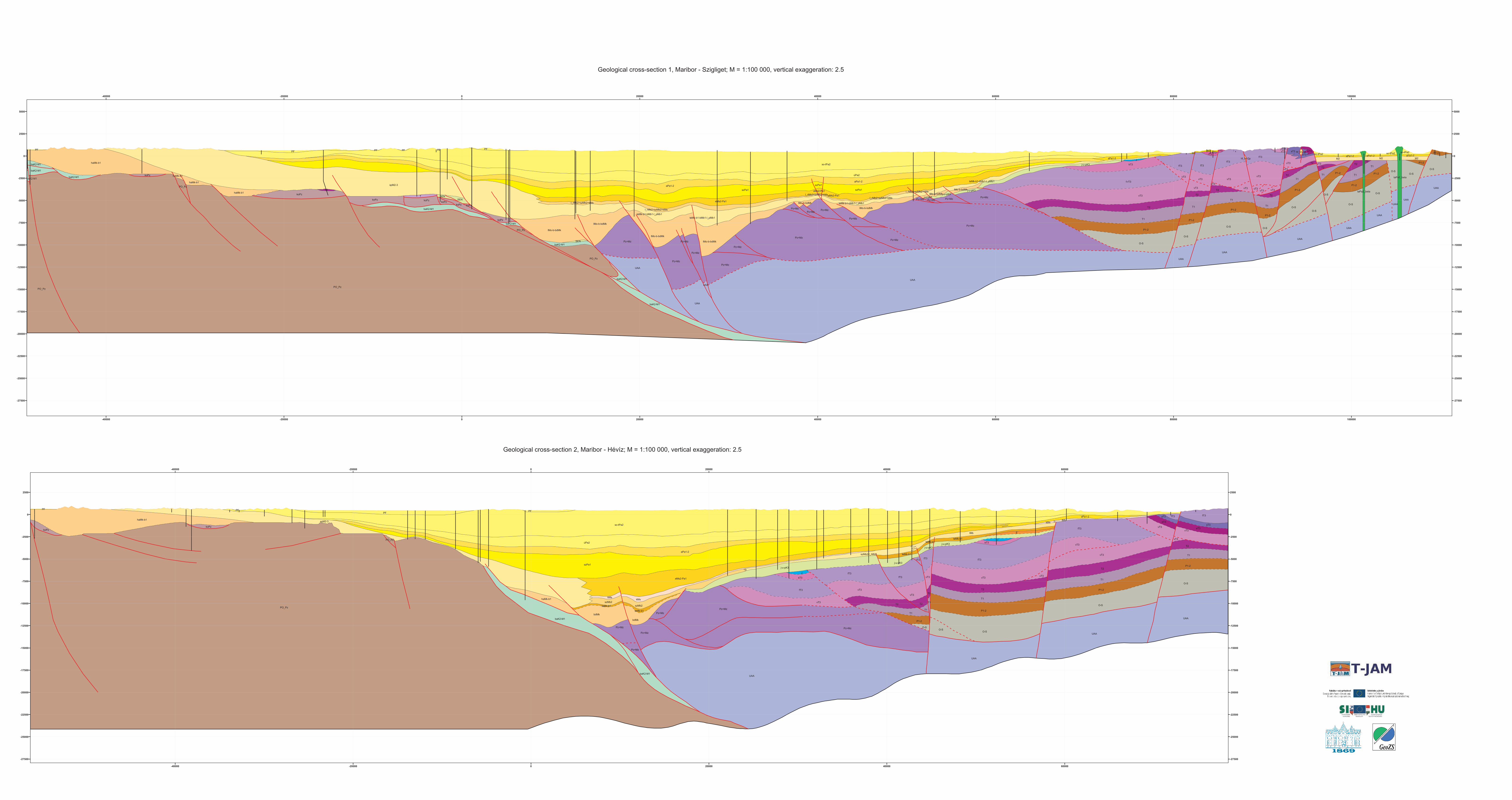
E
J
J
PF PF PFPF
T1
T2
T1
T1
T2
T2
T1
T2
T1T2
T1
T2
sT3
sT3
eT3
eT3
fT3
vT3vT3
vT3
vT3
fT3
fT3
UAA
O-S
vT3
UAA
O-S
UAA
O-S
fT3fT3
vT3
tMs
vT3
fT3
kMs
fT3
kT3
lMb
vT3
vT3fT3
fT3
O-SO-S
vT3
UAA
vT3
kT3
kMskMs
koPzkoPz
P1-2
P1-2
P1-2
P1-2
úPa2
bdMkbdMk
PO_Pz
PO_Pz
Pz+Mz
Pz+Mz
Pz+Mz
szPa1
szMb2
Pz+Mz
Pz+MzPz+Mz
szMb2
spM2-3sPa1-2
aPa1-2
haMk-b1
baK2-M1
haMk-b1
teMk-b1teMk-b1
j-u-pK3teMk-b1
teMk-b1j-u-pK3
j-u-pK3
teMk-b1
j-u-pK3
so-tPa2
baK2-M1
eMs2-Pa1
szMb2-l_rMb2
-40000
-40000
-20000
-20000
0
0
20000
20000
40000
40000
60000
60000
-27500 -27500
-25000 -25000
-22500 -22500
-20000 -20000
-17500 -17500
-15000 -15000
-12500 -12500
-10000 -10000
-7500 -7500
-5000 -5000
-2500 -2500
0 0
2500 2500
T
J
PFPFPFPFPF PF
T2
M2
T1T2
M2T2
M2
T1
T2
T1
T2
T2T1
T2
T1T1
T2
M3M3
T2
T1
T1
T2
UAA
O-S
O-S
UAA
O-S
UAA
UAA
UAA
UAA
UAA
UAA
sT3
UAA
O-SO-S
O-S
O-S
vT3
eT3sT3fT3
vT3
vT3
vT3
O-S
O-SO-S
vT3vT3vT3vT3vT3
vT3vT3
fT3fT3
rT3kT3rT3
fT3fT3
vT3vT3
vT3
O-S
O-S
vT3
kT3
UAA
UAA
UAA
SEN
SEN
SEN
koPz
koPz
koPzkoPzkoPz
úPa2 P1-2
P1-2
P1-2
P1-2
P1-2
P1-2
P1-2P1-2
P1-2
P1-2
koPz
koPzkoPz
PO_Pz
PO_Pz
PO_Pz
PO_Pz
szPa1szPa1szPa1
Pz+Mz
Pz+Mz
Pz+Mz
Pz+Mz
Pz+Mz
Pz+Mz
Pz+Mz
Pz+MzPz+Mz Pz+Mz
Pz+Mz
Pz+MzPz+Mz Pz+MzPz+Mz
Pz+Mz
f-rT3
Pz+Mz
PO_Pz
aPa1-2
sPa1-2sPa1-2sPa1-2sPa1-2
aPa1-2spM2-3
haMk-b1
baK2-M1
baK2-M1
so-tPa2
so-tPa2so-tPa2so-tPa2
j-u-pK3
hf_M-Qp
hf_M-Qp
j-u-pK3
j-u-pK3j-u-pK3
baK2-M1
baK2-M1
baK2-M1
baK2-M1
baK2-M1
haMk-b1
haMk-b1
haMk-b1baK2-M1
baK2-M1
eMs2-Pa1
eMs2-Pa1eMs2-Pa1
taPa2_beta
taPa2_beta
lMo-b-bdMk
lMo-b-bdMk
lMo-b-bdMk
lMo-b-bdMk
lMo-b-bdMk
lMo-b-bdMklMo-b-bdMk
lMo-b-bdMk
l_rMb2+szMb2+kMsl_rMb2+szMb2+kMs
l_rMb2+szMb2+kMsl_rMb2+szMb2+kMs
l_rMb2+szMb2+kMs
teMk-b1-bMb1-l_pMb1
teMk-b1-bMb1-l_pMb1
teMk-b1-bMb1-l_pMb1teMk-b1-bMb1-l_pMb1
-40000
-40000
-20000
-20000
0
0
20000
20000
40000
40000
60000
60000
80000
80000
100000
100000
-27500 -27500
-25000 -25000
-22500 -22500
-20000 -20000
-17500 -17500
-15000 -15000
-12500 -12500
-10000 -10000
-7500 -7500
-5000 -5000
-2500 -2500
0 0
2500 2500
5000 5000
Geological cross-section 1, Maribor - Szigliget; M = 1:100 000, vertical exaggeration: 2.5
Geological cross-section 2, Maribor - Hévíz; M = 1:100 000, vertical exaggeration: 2.5

Q
T1
T1
T2
T3
PF
UAA UAA
fT3
lMbT2-3
T2-3
bdMk
úPa2
Pz+Mz
Pz+Mz
PO_Pz
PO_PzPz+Mz
PO_Pz
pE2-3
szMb2
szPa1
spM2-3
aPa1-2
T1-2-LB
haMk-b1
T1-2-LB
haMk-b1
baK2-M1 teMk-b1
so-tPa2
eMs2-Pa1
-60000
-60000
-40000
-40000
-20000
-20000
0
0
20000
20000
-22500 -22500
-20000 -20000
-17500 -17500
-15000 -15000
-12500 -12500
-10000 -10000
-7500 -7500
-5000 -5000
-2500 -2500
0 0
2500 2500
5000 5000
Geological cross-section 3, Slovenska Bistrica - Ortaháza; M = 1:100 000, vertical exaggeration: 2.5
Geological cross-section 4, Felsőcsatár - Zalacsány; M = 1:100 000, vertical exaggeration: 2.5
J
T2
T1
K1
GP
GP
GPlMb fT3
rT3kT3
vT3
O-S
O-S
fT3
vT3
fT3
vT3
kT3
UAA
UAA
PEN
PEN
úPa2
P1-2
lMb1
lMo-blMo-b
lMo-b
lMo-b
lMo-b
lMo-b Pz+MzPz+Mz
Pz+Mz
szPa1
Pz+MzPz+Mz
Pz+MzPz+Mz
Pz+MzPz+Mz
Pz+Mz
Pz+Mz
sPa1-2
aPa1-2
sPa1-2
so-tPa2
so-tPa2j-u-pK3
j-u-pK3
eMs2-Pa1 teMk-b1+lMb1
teMk-b1+lMb1l_rMb2+szMb2+kMs
teMk-b1+lMb1+pmMb1
0
0
10000
10000
20000
20000
30000
30000
40000
40000
50000
50000
60000
60000
70000
70000
-22500 -22500
-20000 -20000
-17500 -17500
-15000 -15000
-12500 -12500
-10000 -10000
-7500 -7500
-5000 -5000
-2500 -2500
0 0
2500 2500
5000 5000

Geological cross-section 5, Nemesrádó - Szenta; M = 1:100 000, vertical exaggeration: 2.5
Geological cross-section 6, Szentgotthárd - Letenye; M = 1:100 000, vertical exaggeration: 2.5
f_Qp_h,alh
so-tPa2
T1
T2
T2 T1
T1
T2T1
T1
T1T1
T2
SZKUAA
O-S
MTr
UAAUAA
UAA
MTr
fT3
lMb
O-S
vT3
fT3
fT3
sE2
sE2
vT3
O-S
O-S
O-S
MTr
MTr SZK
SZK
SZK
SZK
SZK
T_Pz
P1-2
P1-2
P1-2
P1-2
P1-2
úPa2
bdMk
BALPz
BALPz
szPa1
sPa1-2
szE2-3
aPa1-2teMk-b1
j-u-pK3
j-u-pK3
teMk-b1
teMk-b1
eMs2-Pa1
sz_pE2-3
teMk-b1-lMb
so-tPa2+zPa2
fT3
lMb
kT3sE2
lMb
lMbSZK
P1-2
BALPz
szPa1j-u-pK3
j-u-pK3teMk-b1 eMs2-Pa1
eMs2-Pa1
10000
10000
20000
20000
30000
30000
40000
40000
50000
50000
60000
60000
-22500 -22500
-20000 -20000
-17500 -17500
-15000 -15000
-12500 -12500
-10000 -10000
-7500 -7500
-5000 -5000
-2500 -2500
0 0
2500 2500
hT1
hT1hT1
jK3jK3fT3
PayPay
lMb
mT2
hT1
hT1
mT2
mT2mT2mT2
hT1
hT1
hT1
hT1hT1hT1
hT1hT1
gT2
lMbkMs
kMs lMb
cT1iT2
vT3
fT3 jK3 jK3fT3
vT3
vT3iT2
cT1
fT3vT3
bP2
gT2
gT2
gT2gT2
gT2
pD2
iT2
cT1
bP2
mT2
rE3
spMb
nMb1
bdMk
sbPz
bdMk
dPa2
zPa1
tPa2
lO-D
nMb1
lO-DlO-D lO-D
nMb1
zPa1dPa2
spMb
bO-S
bO-S
bO-S
l_aMo
l_aMol_aMo l_aMo
soPa2
sPa1-2
teMk-b1
bE3-Ol1bE3-Ol1
0
0
10000
10000
20000
20000
30000
30000
40000
40000
50000
50000
60000
60000
70000
70000
80000
80000
-25000 -25000
-22500 -22500
-20000 -20000
-17500 -17500
-15000 -15000
-12500 -12500
-10000 -10000
-7500 -7500
-5000 -5000
-2500 -2500
0 0
2500 2500

Geological cross-section 7, Sentilj - Halozei; M = 1:100 000, vertical exaggeration: 2.5
Geological cross-section 9, Ocinje - Murski Gozd; M = 1:100 000, vertical exaggeration: 2.5
f_Qp_h,alh
so-tPa2
PF
PzPz
LF2MF1MF2
MF2
MF1
LF2
LF1
LF1
T2-3
P1-2P1-2
P1-2PO_Pz
PO_Pz
PO_Pz
PO_Pz
spM2-3
spM2-3
spM2-3
spM2-3
haMk-b1 haMk-b1baK2-M1
baK2-M1
baK2-M1
haMk-b1
T1-2-LBT1-2-LB
haMk-b1
T1-2-LB
T1-2-LB
0
0
10000
10000
20000
20000
30000
30000
40000
40000
50000
50000
-22500 -22500
-20000 -20000
-17500 -17500
-15000 -15000
-12500 -12500
-10000 -10000
-7500 -7500
-5000 -5000
-2500 -2500
0 0
2500 2500
F
F
FF
C
P
SF
GP PF
PFPFPF
SF
SF
HF
HF
HF
T1
MF1
MF1
MF2
LF2MF1
LF1LF2
KPW
LF1
LF2
LF1
KPW
fT3
KPW
PSK
T23T23
T12T12
UAA
UAA
Pz+MzPz+Mz
T1-2-LB
0
0
10000
10000
20000
20000
30000
30000
40000
40000
50000
50000
-22500 -22500
-20000 -20000
-17500 -17500
-15000 -15000
-12500 -12500
-10000 -10000
-7500 -7500
-5000 -5000
-2500 -2500
0 0
2500 2500
f_Qp_h,alh
so-tPa2E
E
LFMF MFMF
LF
Pz
PzPz
MF2
LF2
LF1
MF1
MF1LF2LF1
fT3
PF-QPF-Q PF-Q
T2-3T2-3
T2-3T2-3
T2-3
T2-3T1-2
T1-2
T1-2T1-2 T1-2
P1-2
P1-2P1-2
PO_Pz
PO_Pz
PO_PzPO_Pz
PO_PzPO_Pz
PO_Pz
Pz+Mz
PO_Pz
spM2-3
spM2-3 spM2-3baK2-M1baK2-M1
haMk-b1
haMk-b1
haMk-b1haMk-b1
haMk-b1
baK2-M1
baK2-M1
baK2-M1
10000
10000
20000
20000
30000
30000
40000
40000
50000
50000
-22500 -22500
-20000 -20000
-17500 -17500
-15000 -15000
-12500 -12500
-10000 -10000
-7500 -7500
-5000 -5000
-2500 -2500
0 0
2500 2500
Geological cross-section 8, Trate - Sredisce ob Dravi; M = 1:100 000, vertical exaggeration: 2.5