Embed Size (px)
Citation preview
UNITED STATES DEPARTMENT OF THE INTERIOR
GEOLOGICAL SURVEY
SUMMARY OF REFERENCES TO MINERAL OCCURRENCES
(OTHER THAN MINERAL FUELS AND CONSTRUCTION MATERIALS)
IN THE COBDOVA QUADRANGLE, ALASKA
BY Edward H. Cobb
O p e n - f i l e Report 79-973 1979
This report is p r e l i m i n a r y and h a s not been e d i t e d or reviewed for conformiry with Geological Survey standards a n d nomenclature.
Inrroduction
This summary of references is designed to aid in library research
on metallic and nonmetallic (other than mineral fuels and constracdian
materials) mineral occurrences in the Cordova quadrangle, Alaska. Re-
ferences to most reports of the Geological Survey, U. S. Bureau of Mines,
and State of Alaska Division of Geological and Geophysical Surveys and
its predecessor agencies released before January 1, 1979, are included.
Certain, mainly statistical, reports such as the annual Minerals Year-
book of the U.S. Bureau of Mines and the biennial and annual reports of
the Alaska Division of Geological and Geophysical Surveys and its prede-
cessor agencies are not included. Also notr included are data on many
prospects and claims about which little more than their locations is
known (for example, many of those in Condon, 1965 (1 -453) and some in
MacKevett and Holloway, 1977 (OF-77-169A), p. 15). These omissions
should not be interpreted as a judgement on my part that the prospects
and claims are not valid mineral occurrences, but only that there are
insufficient data to describe any mineral deposits that might be present.
This report is divided into three parts: a section made up of sum-
maries of references arranged alphabetically by occurrence name; a section
rhat lists synonyms for names in the first section, claim names, and the
names of operators and owners of mines and prospects; and a section that
lists, by author, all references in the first section and in these intro-
ductory paragraphs.

I n d e x map
2

Summaries of References
For each mineral occurrence there is a page that gives the name
of the occurrence; the mineral commodities present (listed alphabeti-
cally), rhe mining district (Ransome and Kerns, 1954 ( I C 7679))in which
the occurrence is located; the name of the 1:250,000-scale topographic
(Cordova); coordinates (as described by Cobb and KAchadoorian,
1961 (B 1139), p. 3-4); the metallic mineral resources map number (MF-392)
and the occurrence number on the map if the occurrence is shown; and the
latitude and longitude of the occurrence. These data, presented at the
top of the page, are followed by a short, general summary of the published
information on the occurrence. This is followed (continued on additional
pages if necessary) by more detailed summaries, arranged chronologically,
of all references to rhe occurrences. In a feu instances data from the
field notes of geologists are also included, but I made no attempt to
study all of the possibly applicable notebooks. Material in brackets is
interpretive or explanatory and is not in the summarized reference.
Proper names of mines, prospects, and other mineral occurrences
are given if such names appear in the reports summarized. If a part of
a proper name is not always used in a reference, that part of the name
is shown in parentheses. If a deposit does not have a proper name, but
is near a named geographic feature, the name of that feature is shown in
parentheses in Lieu of a proper name.
Citations are given in standard bibliographic format with the excep-
tion that references to reports and maps in numbered publication series
also show, in parentheses, an abbreviation for the report of map series
and the report or map number. Abbreviation used are:
B BMB C I
Alaska Division of Geological and Geolphysical Surveys Open-file Report
U.S. Geological Survey Bulletin U.S. Bureau of Mines Bulletin U.S. Geological Survey Circular U.S. Geological Survey Miscellaneous Geologic Investi-
gation Map U.S. Bureau of Mines Information Circular U.S. Geological Survey Open-file Report U.S. Geological Survey Miscellaneous Field Studies Map U.S. Geological Survey Professional Paper U.S. Bureau of Mines Report of Invesrigations

Summaries are as I made tham while reading the c i t e d reports. I
made no attempt to use complete sentences and did not edit f o r grammatical
consistency, although I tried to edit out ambiguities.

Alaska Commercial Co. Copper, Gold, Lead, Silver, Zinc
Prince William Sound district Cordova (3.9, 15.0) MR-392, loc. 14 600511N, 146032'W
Summary: Site of original copper discovery in area, 1897. Over 500 ft. of workings, mainly driven before 1905, when about 70 tons of ore was shipped. Most recent activity reported was in 1915. Ore in 2 sulfide lenses in shear zone in greenstone (with some interbedded graywacke and slate) of Orca Gp. Sulfides include chalcoyrite, pyrrhotite, sphalerite, galena, arsenopyrite, and cubanite(?); as much as 0.18 oz. gold and 0.26 oz. silver a ton in assays. Property eventually owned by Threeman Mining Co. Includes references ro: A.C. (Co.), Copper Mountain, Jacobson. See also (Bligh I.).
Schrader, 1900, p. 417-418 -- Copper ore in talus led to discovery o f vein in 1897; in shear zone in greenstoneor amphibolite schist. Ore consists of chalcopyrite, bornite, marcasite, pyrite, and some quartz and specularite. Samples contained 11.4% and 12.5% copper.
Grant, 1906 (B 284), p. 83-84 -- Shear zone in greenstone is about 4 Et. thick, strikes ~ 6 8 ' ~ ~ and dips 75'-80'~. Contains layer pyrrhotire and chalcopyrite 2-8 in. thick. About 70 tons of ore was shipped in 1905. Tunnel run 412 ft. to undercut ore boby; did not reach it unless a barren, narrow shear zone represents the vein.
Capps and Johnson, 1913 (B 542), p. 119-121 -- Preliminary to Capps and Johnson, 1915 (B 605).
Johnson, 1914 (B 5 9 2 1 , p. 241 -- Underground development, 1913. Capps and Johnson, 1915 (I3 605) , p. 13 -- First claim staked, 1897.
p. 52-54, 56 -- Data from older reports. Part of a quotation from Emerson, B. K., 1904 in Harriman Alaska Expedi~ion, General Geology, Alaska, v. 4, p . 24-25, follows: "The deposit of copper ore is a mass of quartz, with chalcopyrite, pyrrhotite, and small amounts of galena and sphalerite, occupying a shear zone in a rock of serpentinous character."
p. 70-71 -- Arsenopyrite appears to h a ~ e been the first sulfide to form.
p. 107-108 -- Located in 1897; more than 500 ft. of underground workings in 1898-99 and some high-grade ore shipped. More develop- ment, 1912-13. Country rock mainly greenstone; some interbedded slate and graywacke. Ore in shear zone about 30 ft. wide that in- cludes large lenses of unsheared greenstone. Sulfides in most highly sheared material and in joints in unsheared rock. Highly mineralized zone is 2-10 (average 4) ft. wide; strikes N850W, dips 600N, and is traceable along strike for about 250 ft. Ore probably formed by re- placement of greenstone with some cementation of small fractures. Sulfides are chalcopyrite, pyrrhotite, sphalerite, galena, arseno- pyrite, and an undetermined sulfide [cubanite?]; gold and silver re- ported in assays.

Alaska Commercial Co. -- cont . Johnson, 1915 (B 622), p. 133 -- Ore reported to have been found, 1914. Johnson, 1916 ( B 6421, p. 140 -- Crosscut(s) driven by Threeman Mining
Co., 1915. Smith, 1917 (BMB 142), p. 43 -- Owned by Three Man Mining Co. Smith, 1917 (BMB 1531, p. 50 -- Same as above. Moffit and Fellows, 1950 (B 963-B), p. 48 -- First copper discovery in
Prince William Sound, 1897. p. 59 -- In 1915 included 3 tunnels with a total length of more
than 532 ft. Several tons of high-grade material reported to have been shipped.
Mihelich and Wells, 1957 (RI 5 3 2 0 ) , p , 3 -- Claim data. p . 6 -- Were no ore shipments [does not agree with data in some
of older reports]. p. 14 -- Mine map. Samples assayed contained as much as 6.0%
Cu, 1.4% Zn, 0.26 oz. a ton Ag, and 0.18 oz. a ton Au. p. 18-19 -- Prospect located in 1897. Drift driven 200 ft. from
tunne1;along shear zone; exposed 2 lenses of chalcopyrite, pyrrhotite, and pyrite with total length of over 100 ft. and 1.5-3.2 f t . thick. Other exploratory openings and trenches not visible when visited by USBM, 1955.
MacKevett and Holloway, 1977 (OF 77-169A), p . 14, loc. 10 -- References to Capps and Johnson, 1915 ( B 605), and Mihelich and Wells, 1957 ( R I 5320). Country rock mainly greenstone of Orca Gp.

Banzer Copper, Gold, Lead, Zinc
Prince William Sound district Cordova (3.9, 14.3) MF-392, LOC. 17 60049'N, 146033'W
Summary: Quartz stringers and bunches in slare of Orca Gp. contain chalcopyrite, pyrrhotite, pyrite, sphalerite, galena, and gold; assays as high as about 2.42 oz. gold a ton reported. A little work done in early 1 9 0 0 1 s , but no recorded produc- tion. Banzer also is reported to have done some work in 1917 on a copper prospect somewhere near the head of Port Fidalgo (Johnson, 1919 (B 692), p. 149).
Capps and Johnson, 1913 (B 5 4 2 ) , p . 123-124 -- Preliminary to Capps and Johnson, 1915 (B 6 0 5 ) .
Capps and Johnson, 1915 (B 6051, p. 112 -- 2 shafts and several hundred feet of stripping before 1912. Country rock contorted slate and greenstone; many stringers and bunches of quartz in slate. Quarrz on dump contains chalcopyrite, pyrrhotite, sphalerire, and galena; a little calcite gangue. Assays as high as $50 [about 2.42 02.1 a ton in gold reported; may not have been an average sample.
MacKevett and Holloway, 1977 (OF 77-169A), p. 14, loc. 12 -- Reference to Capps and Johnson, 1915 ( B 605). Bedrock is Orca Gp.

Bayview Copper(" )
Prince William Sound district Cordova 16.25, 17.45) approx. 61°00'~, 146O16'~ approx.
Summary: Copper prospect; claim Located on a mineralized zone in green- stone at head of Solomon Gulch. No data on deposit other than approximate location.
Johnson, 1919 (B 692), p. 165 -- Copper prospezt nearly 2,500 ft. above sea level on Solomon Gulch. [other Solonon Gulch prosbects and mine are in Valdez quad.]
p. 171 -- Claim staked on a minera1i:ed zone in large green- stone area that crosses head of Solomon iulch at elevation of about 2,500 ft.; 1% mi. south of Midas mine.
Mulligan, 1974 (IC 8626), p . 22 -- Data from J+,hnson, 1919 ( B 692), p . 171 [not cited]. [~ncorrectl~ located ill Valdez quad.]
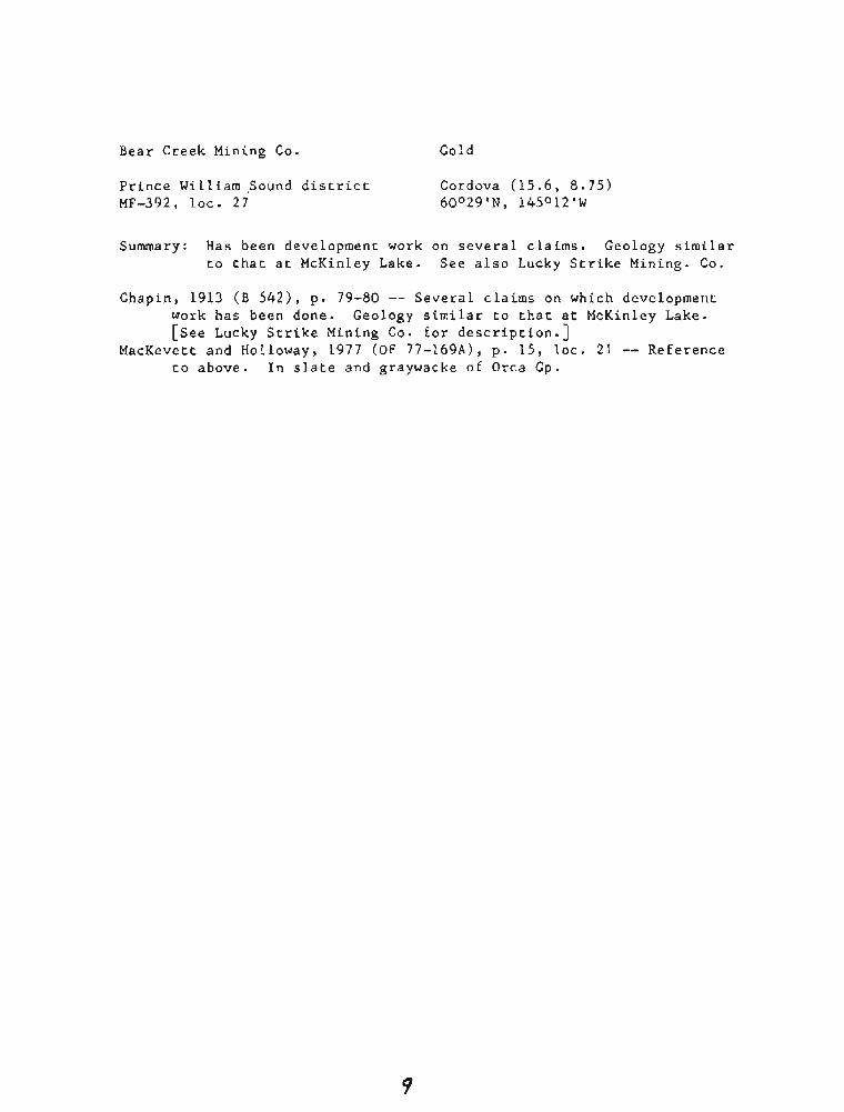
Bear Creek Mining Co. Go 1 d
Prince William Sound district Cordova (15.6, 8.75) MF-392, loc. 27 60029'N, 145O12'W
Summary: Has been development work on several claims. Geology similar to that at McKinley Lake. See also Lucky Strike Mining. Co.
Chapin, 1913 (B 542) , p. 79-80 -- Several claims on which development work has been done. Geology similar to chat at McKinley Lake. [see Lucky Strike Mining Co. for description.]
MacKevett and Holloway, 1977 (OF 77-169A), p . 15, loc. 21 -- Reference to above. In slate and graywacke of Orca Gp.

(Bligh I.) Gold
Prince William Sound district Cordova (2.25, 15.3) approx. MF-392, loc. 2 60053'N, 146045'W approx.
Summary: Quartz pod in rocks of Orca Gp. (Paleocene) contained much gold (assay as high as about 121 oz. a con reported) was mined out in early 1900's.
Capps and Johnson, 1913 (B 5 4 2 ) , p. 123 -- Preliminary to Capps and Johnson, 1915 ( B 6 0 5 ) .
Capps and Johnson, 1915 (B 6051, p. 112 -- Old prospec t of Alaska Commercial Co. at NE corner of island on a mass of quartz said to have assayed as high as $2,500 [about 121 02.1 a ton in gold. Reported to have been worked out. Shaft caved and nothing visibl 912.
MacKevett ang ASlioway, 1977 (OF 77-169A), p . 14, loc. 2 -- Reference to Capps and Johnson, 1915 (B 615). Gold-bearing quartz pod in Orca Gp. (Paleocene).

(Bremner R.) Go 1 d
Nizina district ME-392, loc. 31
Cordova (24.3, 18.0) ~ O ~ O O ' N , 144°08'~
Summary: In early 1900's rhere were attemprs to mine fine gold from glaciofluvial sand and gravel terrace on glaciated bedrock of Valdez Gp. Total production probably no more than a few tens of ounces of gold. Includes references to (Threemile Canyon).
Moffit, 1912 (B 520) , p . 99-100 -- Preliminary to Moffir, 1914 ( B 576). Moffit, 1913 ( B 576), p . 44 -- Yield of placer gold worth no more than
a few hundred dollars. p. 47-48 -- Bench on north side of river about 4 mi. above
Threemile Canyon was being mined in 1911. Sand and fine gravel containing fine gold rests on glaciated surface of slate or graywacke bedrock. Sluiced with water from a small stream that went dry in the middle of the summer. Fine gold also on river bars. In 1911 one man was working on a small tributary that flows into river in Threemile Canyon; had been more interest in 1907, but returns were disappointing.
Cobb, 1973 ( B 1374), p. 32 -- In early 1900's were attempts to mine glaciofluvial deposits.
Henning and Dobey, 1973 (AOF 251, p. 12-13 -- Reference to Moffit, 1914 ( B 576).
MacKevett and Holloway, 1977 (OF 77-169A), p. 15, loc. 24 -- Reference to Moffit, 1914 (B 576). In Valdez Gp. terrane.

Chisna Consolidated Mining Co. Copper, Gold, Silver
Prince William Sound district Cordova (4.0, 14.8) MF-392, loc. 16 60°51'N, 146O32'W
Summary: Chalcopyrite and pyrite in shear zones in greenstone. Best copper assay reported is 0.64%; traces of gold and silver. A little exploration in about 1909.
Capps and Johnson, 1915 (B 605), p . 111-112 -- Company said to have been promoted in 1909. 40-ft. inclined shaft and a few open cuts; only assessment work in recent years [ a s of 19121. Slightly mineralized schistose greenstone on trace of Landlock thrust.
Mihelich and Wells, 1957 (RI 5 3 2 0 ) , p. 6 -- In early 1900's was active prospecting, but no production.
p. 15 -- Map of prospect. Assays of samples showed as much as 0.64% Cu, 0.04 oz. a ton silver, and traces of gold.
p. 19 -- In upper plate of Landlock thrust fault. Explored by 40-Et. inclined shaft sunk in a shear zone about 40 ft. wide that strikes ~ 3 0 ' ~ and dips 35'~~; thin films of chalcopyrite and of pyrite and gouge in fractures in greenstone. 20-ft, tunnel driven to crosscut a fracture zone 5 ft. thick that strikes N300E and dips 35'~~.
MacKevett and Holloway, 1977 (OF 77-169A), p . 14, loc. 11 -- References to above. Country rock Orca Gp.; mainly greenstone.

(Cloudman Bay) Copper, Gold, Zinc
Prince William Sound district Cordova (2.3, 14.65) approx. MF-392, loc. 3 60°50'~, 146O44'W approx.
Summary: Srockwork of drusy quartz veins in slate of Orca Gp. con- tains chalcopyrite, pyrite, sphalerite and as much as $4.80 (about 0.23 02.) a ton in gold. Some surface strip- ping before 1912.
Capps and Johnson, 1913 ( B 5421, p. 123 -- Preliminary to Capps and Johnson, 1915 (B 605) .
Capps and Johnson, 1915 (B 605), p. 112 -- Stockwork of about equal parts slate and drusy quartz is 20-30 ft. wide; gouge seam 4 in. wide along one wall and 2 small faults with gouge along the other. Crops out below high tide; stripped back 40 ft. from beach. Quartz contains sulfides, including chalcopyrite, pyrite, and sphalerite. Samples across 30-ft. width of stock- work ran $2 to $4.80 [a ton, presumably in gold at $20.671.
MacKevett and Holloway, 1977 (OF 77-169A), p. 14, loc. 3 -- Reference to Capps and Johnson, 1915 (B 605). Stockwork in slates of Orca Gp. [shows sb (sribnite) in description; lapsus for S 1 (sphalerite) .]

(Copper Mtn.) Copper
prince William Sound district Cordova (3.7-3.9, 15.0-15.2) 60'51'-60°52'~, 146032'-146°35'W
Summary: Copper deposits in fissure veins in greenstone with small amounts of slate, graywacke, and quartzite. See also: Alaska Commercial Co., Hemple Copper Co., Montezuma, Rey- nolds-Alaska Development Co. (Landlocked Bay), Standard Copper Mines Co.
Schrader and Spencer, 1901, p. 88 -- Fissure-vein copper deposits. Grant, 1904 (B 2 8 4 ) , p. 82 -- Country rock greenstone with small
amounts of slate, graywacke, and quartzite. Site of principal interest of prospectors in general area.

(Copper R. bars) Gold
Prince William Sound district Cordova (11.5-15.3, 4.3-7.0) approx. 60015'-60024'N, 145015'-145040'W approx.
Summary: Bars off Copper R. delta contain fine gold derived from Copper R. drainage basin. Samples contained as much as 0.250 ppm gold. Pete Dahl Bar of this report (below) is near Copper Sands of most maps.
Reimnirz and Plafker, 1976 ( B 1415), p. 9-10 -- Bars off mouth of Copper R. contain fine gold. Samples from 2 bars (Green Island Bar and Pete Dahl Bar) contained from 0.003 to 0.250 ppm gold. Gold and other heavy minerals derived from Copper R. drainage basin rather than broughtfrom east by longshore drift; very little gold east of main channel of river. Pete Dahl Bay appears to be as good as (or better than) Yakataga beaches [ ~ e r i n ~ Glacier quad.] as a place for beach placer mining.
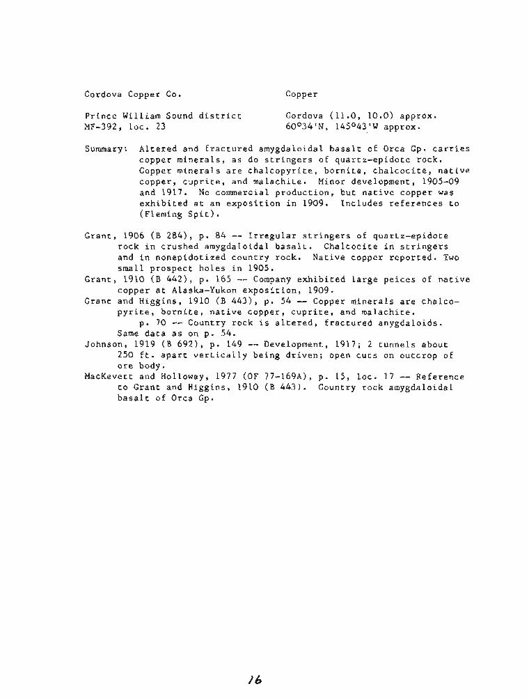
Cordova Copper Co. Copper
Prince William Sound district Cordova (11.0, 10.0) approx. MF-392, Loc. 23 60°34'N, 145O43'W approx.
Summary: Altered and fractured amygdaloidal basalt of Orca Gp. carries copper minerals, as do stringers of quartz-epidote rock. Copper minerals are chalcopyrite, bornite, chalcocite, native copper, cuprite, and malachite. Minor development, 1905-09 and 1917. No commercial production, but native copper was exhibited at an exposition in 1909. Includes references to (~leming Spit).
Grant, 1906 (B 284), p. 84 -- Irregular stringers of quartz-epidote rock in crushed arnygdaloidal basalt. Chalcocite in stringers and in nonepidotized country rock. Native copper reported. Two small prospect holes in 1905.
Grant, 1910 (B 442), p . 165 -- Company exhibited large peices of native copper at Alaska-Yukon exposition, 1909.
Grant and Higgins, 1910 (I3 4 4 3 ) , p . 54 -- Copper minerals are chalco- pyrite, bornite, native copper, cuprite, and malachite.
p. 70 -- Country rock is altered, fractured anygdaloids. Same data as on p. 54.
Johnson, 1919 ( B 6 9 2 ) , p. 149 -- Development, 1917; 2 tunnels about 250 ft. apart vertically being driven; open cuts on outcrop of ore body.
MacKevett and Holloway, 1977 (OF 77-169A), p. 15, loc. 17 -- Reference to Grant and Higgins, 1910 ( B 443). Country rock amygdaloidal basalt of Orca Gp.

Dickey Copper Co. Copper, Gold, Zinc
Prince William Sound district Cordova (5.0, 13.4) MF-392, loc. 20 60046'N, 146025'W
Summary: Country rock is graywacke, argillite, and slate of Orca Gp.; no greenstone or other igneous rock. Shear zone contains chalcopyrite, pyrite, sphalerire, pyrrhotite, and gold in quartz and calcite gangue. Sulfides appear to have preferen- tially replaced certain (possibly originally limy) beds. Some postmineralization movement. 1,000 or more feet of underground workings. Property active fromabout L907 to about 1917; some ore (amount not known) shipped, 1914-17. Includes references to: Irish Cove, Mason & Gleason.
Brooks, 1912 (B 5 2 0 ) , p . 27 -- Some work done on property by Threeman Mining Go. in 1911.
Brooks, 1913 (B 542), p. 34 -- Development reported, 1912. Brooks, 1914 (B 592) , p. 62 -- Some ore mined and sledded to beach, 1913. Johnson, 1914 (B 5921, p. 241-243 -- Discovered, 1907. Devlopment until
1913; several hundred feet of underground workings on 3 levels; surface improvements; about 600 tons of ore mined, but not shipped; in ore bunkers (as oE July, 1913).
Capps and Johnson, 1915 (B 605), p. 119-122 -- Chalcopyrite, pyrite, and quartz fill irregular, small, tubular wormlike channels in sediment- ary rocks. Data on history and development of property essentially as in Johnson, 1914 ( B 592). Country rock is series of interbedded graywacke, argillite, and slate (no igneous rocks); all sheared in a zone traced for 300 ft. in workings; most individual shears strike between N and N~O'E, apparently closely parallel to bedding; has been some postmineralization movement. Ore in shear zone; consisrs of chalcopyrite, pyrite, sphalerite, and pyrrhotite; considerable gold reported to be in parts of ore body; gangue minerals are quartz and calcite. Gold generally in parts of ore body that are lowest in chalcopyrite and high in sphalerite. In many places chalcopyrite appears to have preferentially replaced certain (possibly originally limy) beds.
Johnson, 1915 ( B 6 2 2 ) , p. 133-134 -- Development work, 1914; some ore said to have been found.
Johnson, 1916 (B 642), p. 141 -- Operated Nov.-Dec., 1915. Ore bunkers and wharf erected in Irish Cove.
Johnson, 1918 (B 662), p. 184 -- Ore shipped, 1916. p . 187 -- 500-600 f t . of underground work done, 1916. Several
hundred tons of ore shipped. Johnson, 1919 (B 692), p. 144 -- Ore shipped, 1917.
p. 149 -- Property not known to have operated, 1917, but ore shipment said to have been made.
Brooks, 1912 ( B 7141, p. 22 -- Deposit in shear zone in slate and graywacke; slate more crushed than graywacke.

Dickey Copper Co. -- c o n t . £fit and Fellows, 1950 ( B 963-B), p . 62 -- Most of data from Capps and
Johnson, 1915 (B 605). About 600 tons of ore mined, but not shipped, 1913. Ore consisrs of chalcopyrite, pyrite, sphalerite, and pyrrhot- ite in shear zone in graywacke, argillite, and slate; no greenstone. Ore carries considerable gold.
MacKevett and Holloway, 1977 (OF 77-169A), p. 14, loc. 14 -- References to Capps and Johnson, 1915 ( B 605) and Moffit and Fellows, 1950 ( B 963-B). Country rock part of Orca Gp.

Ellamar (Mining Co.) Copper, Gold, Lead, Silver, Zinc
Prince William Sound district Cordova (2.55, 15.7) MF-392, LOC. 4 60°54'~, 146O42'W
Summary: Strata-bound submarine volcanogenic deposit in flysch of Tertiary Orca Gp. near tholeiite. Principal ore body (considered to have been mined out) was a lenticular mass extending from surface bwash at high tide) to depth of 530 ft. where it pinched out; cross section on 200-ft. level was an ellipse with axes of 240 ft. and 90 ft. Hanging wall part of deposit was a solid mass of pyrite separated from underlying copper-sulfide ore by a 2-ft.- thick body of black slate. Ore minerals were chalcopyrite, cubanite, pyrite, pyrrhotite, sphalerite, and galena; carried gold and silver, particularly in sphalerite-rich ore. Staked in 1897 and operated until mine was closed in 1920. One of two major copper mines in district; produced about 100 million pounds of copper and byproduct gold and silver (amounts not known). Pyrite supplied as smelter feed. Developed by workings on sev- eral levels (deepest 600 ft.) and inside coffer dam that allowed stoping to surface. Methane encountered in raises driven in slate in hanging wall to obtain material to backfill stopes. In- cludes references to Gladhaugh.
Schrader, 1900, p. 418-419 -- In 1898 a deposit about 300 E r . wide was being worked. Deposit known as early as 1895; staked in 1897. Country rock is gray arkose cut by a diabase dike, which "seems to have something to do with mineralization of the ore deposit." Deposit exposed only at low tide. Ore largely chalcopyrite and tetra- hedrite with some bornite and epidote and much marcasite.
Schrader and Spencer, 1901, p. 89 -- Country rock is folded and sheared black shales. Vein is practically solid mass of copper and iron pyrites; 125 ft. wide where exposed; extends known distance of more than 300 f t . along strike. North wall strikes N450W and dips 300N; south wall dip is considerably sreeper. Vein has small inclusions of country rock, some calcite lenses, and a little bornite. Sample assayed 5.4% copper and 0.1 oz. gold a ton. Shaft being sunk in 1900; plan TO crosscut to vein at depth of 150 ft.
Grant, 1906 ( B 2841, p. 81-82 -- Staked in 1897. In 1905 shipped about 1,500 tons of ore per month during summer. 5 levels (deepest TOO-ft. level); on 200-ft. level ore body has lens-shaped cross section 190 ft. long and 80 ft. wide. Ore body consists of chalcopyrite, pyrite, pyrrhotite, and varying amounts of slate country rock; mainly massive with a few calcite-filled cracks. Country rock much fractured and slickensided.
p. 87 -- Only producing copper mine in Prince William Sound in 1905.
Brooks, 1907 (B 314), p. 27 -- Ore shipped, 1906. Mine said to ahve reached 6th level at 600 ft. depth

Ellamar (Mining Co.) -- cont. Moffit, 1908 (B 3 4 5 ) , p. 178 -- Partly idle, 1907 (labor trouble); shaft
sunk to 600-ft. level and 650 fc. of drifts run. Grant and Higgins, 1909 (B 379), p. 87-88 -- Staked in 1897. Making
regular shipments of ore, 1908. p. 94-95 -- Output decreased, 1908; lower grade material outside
of poorly defined ore shoot being mined. Ore body pinched out between 500-ft. and 600-ft. levels. Prospecting for other ore bodies by dia- mond drilling along strike of lens being mined.
Brooks, 1910 (B 442), p. 32 -- Began shipping ore in 1901. p. 39 -- Mining, 1909.
Grant, 1910 (B 442), p. 164 -- Dam to keep out sea water being constructed to allow mining from 100-ft. level to surface, 1909.
Grant and Higgins, 1910 (B 443), p . 52-53 -- Staked in 1897. One of 2 mines in Prince William Sound that made regular shipments of copper ore. Crystals of pyrite occur rarely.
p. 56-57 -- Ore body is a lens-shaped mass with maximum and min- imum horizontal axes of 190 ft. and 80 ft. Unmetamorphosed diabase dike "may have played an important part in the formation of the ore body.. . ."
p . 59-61 -- Essentially the same data as in Grant and Higgins, 1909 (B 379), p . 94-95. In 1909-10 coffer dam being built so ore between 100-ft. level and outcrop (under water at high tide) can be mined.
p. 78 -- Small amounts of sphalerite occur wirh copper minerals. Brooks, 1911 (B 4801, p. 31-32 -- Coffer dam completed and some ore shipped,
1910. Brooks, 1911 (B 480), p. 81 -- Data from Grant and Higgins, 1910 ( B 443). Brooks, 1912 (B 5201, p. 27 -- Ore shipped in 1911 was from upper level. Capps and Johnson, 1913 (B 5421 , p . 97, 100-102 -- Preliminary to Capps
and Johnson, 1915 (B 605). Brooks, 1914 (B 592), p . 62 -- Operated at full capacity, 1913. Johnson, 1914 ( B 592), p. 240-241 -- Data on mining methods and surface
plant. Average of 40 men worked throughout 1913. Capps and Johnson, 1915 (B 605), p . 13-14 -- Staked, 1897. Ore first ship-
ped in 1900 and regularly since then. p. 51 -- Ore as much as 600 ft, below sea level. Mine produced
in 1912. p. 52-55, 57-61 -- References to and quotations from older
reports . p. 62-64 -- Ore deposit in shear zone that parallels bedding of
country rock; has been slight postmineralization movement in shear zone.
p . 71-72 -- Tiny veins of chalcopyrite with a little sphalerite cut earlier sphalerite. Very little copper in a massive pyrite lens.
p. 87-92 -- Largely descriptions of workings and mining methods as of 1913; about 4,000 ft. of drifts and crosscuts on 8 levels plus stopes between several levels. Ore body is a lenticular mass with

Ellamar (Mining Co.) -- cont. elliptical cross section on 200-ft. level with major axis of 240 ft. and minor axis of 90 ft., strikes about N ~ ~ O W , dips ~O'NE, pitches steeply SE, and appears to conform to bedding of graywacke and slate country rock. Sulfides are chalcopyrite, pyrrhotire, sphaler- ite, and pyrite; gold and silver associated with sphalerite (specimens of sphalerite have assayed as much as $90 [about 4.35 oz.] a ton gold!. Galena,.pruhab.lypresent; lead in assays. Gangue is quartz, calcite, and fragments of country rock. Pyrite earliest sulfide. Sulfides im- pregnated and replaced shattered country rock (including some lime- stone and limy beds) and first-deposited pyrite.
Brooks, 1915 (B 622), p . 45 -- Copper ore shpiments at normal rate, 1914. Johnson, 1915 (B 622), p. 131 -- Ore shipments, 1914.
p . 133 -- Entire sulfide body being mines, 1914; mine is a large producer of copper and gold; smaller amounts of silver. Development was between 400-ft. level and surface; some workings in slate country rock.
Johnson, 1916 (B 642), p. 138 -- Large shipments as usual, 1915. p. 140 -- Work continued, 1915. Raises in slate country rock
reported to have encountered explosive gases. Smith, 1917 (BMB 142), p. 39 -- Mainly data on mining methods. Smith, 1917 (BMB 153), p. 44-45 -- Mainly data on mining methods and equip-
ment. Methane encountered in raises in graphitic slate of hanging wall being driven to provide material for backfilling stopes.
Brooks, 1918 (B 662), p . 44 -- One of largest copper producers in Prince William Sound, 1916.
Johnson, 1918 (B 662), p. 184-186 -- Mining, diamond drilling, and surface improvements, 1916.
Johnson, 1919 (B 692), p. 144 -- Ore shipped, 1917. p. 147 -- Operated for nearly all of 1917. Considerable surface
improvements and some diamond drilling. Martin, 1919 (B 692), p. 31 -- Operated on about the usual scale, 1917. Martin, 1920 (B 712), p . 33 -- Operated at reduced capacity (shortages of
labor and shipping space), 1918. Brooks, 1921 ( B 7 1 4 ) , p. 22 -- Ore in shear zone in slate; ore body is
lenticular and may have been formed by replacement of calcareous lens in slate.
Brooks and Martin, 1921 (B 714), p. 69 -- Mine worked throughout 1919. p. 77 -- Work in 1919 on about the same scale as in the past.
Brooks, 1922 (B 7221, p. 20 -- Mine closed, 1920. Bain, 1946 ( I C 73791, p. 33 -- Was one of the rwo major copper mines in
Prince William Sound. Considered worked out. Moffit and Fellows, 1950 (B 963-B), p. 50 -- Ellamar and Latouche [~eward
quad.] produced more than 96% of the 214 million pounds of copper from Prince William Sound.
p. 55-56 -- Most of data from Capps and Johnson, 1915 (B 605). Mine reported to have closed because ore was too low grade to be profirable under 1919 conditions. Galena probably present; smelter returns showed lead.

Ellamar (Mining Co.) -- cont.
Moffit, 1954 (B 989-E), p. 228 -- Claims staked, 1897. p. 297-298 -- Most productive mine in northeastern part of Prince
William Sound. Produced copper, gold, and silver and pyrite for smelter use. Ore body was a steeply pitching lenticular mass of sul- fides in slate and graywacke of Orca Gp.; reported t o have pinched out at depth of 530 ft. Lens of solid pyrite formed hanging wall; underlying ore (separated from pyrite body by 2-ft.-thick body of black slate) consisted of parallel lenses of chalcopyrite, pyrrhotite, and sphalerite. Most of gold and silver in sphalerite. Pyrite old- est sulfide; sphalerite youngest.
p. 302 -- Same as Moffit and Fellows, 1950 (B 9633B), p . 50. Berg and Cobb, 1967 (B 1246), p . 69 -- Data summarized or quoted from
Moffit, 1954 (B 989-E). Koschmann and Bergendahl, 1968 (P 610), p. 32 -- Copper ores at Ellamar
and Latouche [~eward quad.] carry considerable amounts of gold; amount produced could not be determined.
MacKevert and ~olloway, 1977 (OF 77-169A), p. 14, loc. 4 -- References to Capps and Johnson, 1915 (I3 605) and Moffit and Fellows, 1950 (B 963-B). Sulfide-rich lenses in Orca Gp. graywacke and slate near submarine basalt. Mine produced about 100 million pounds of copper and some byproduct gold. Ore consists of chalcopyrite, cub- anite, pyrrhotite, pyrite, sphalerite, and galena.
Winkler and others, 1977 (C 751-B), p. B44-B45 -- One of the principal copper deposits of Prince -William Sound. Recent regional studies indicate that the deposits in the district are mostly strata bound and are syngenetic and related to recurring tholeiitic volcanism. Ore in thick pyritic sandstone and shale on margin of tholeiite.
MacKevett and others, 1978 ()F 78-1-E), p . 15 -- Data on production same as in many older reports. Deposits of area including ~llamar] are submarine volcanogenic in origin. Area underlain by flysch and mafic volcanic rocks of Tertiary Orca Gp.

Falck Copper, Zinc
Prince William Sound district Cordova (3.85, 15.2) MF-392, loc. 12 60°52'N, 146033'W
Summary: Shear zones in greenstone and other rocks of Orca Gp. con- tain quartz, calcite, chalcopyrite, pyrrhotite, sphalerite, and (on surface only) small flakes of native copper. No more than assessment work reported.
Capps and Johnson, 1915 (B 605), p . 72 -- Small flakes of native cop- per on weathered outcrops of lode.
p. 103-104 -- Claims located in about 1900; only assessment work has been done on them; short adit and open cuts. Country rock mainly greenstone; some black slate and a little graywacke. Generally northeastward-striking steeply d i p p i n g shear zones con- tain quartz, calcite, chalcopyrite, pyrrhotite, sphalerire, and (on surface showings only) secondary naive copper.
MacKevett and Holloway, 1977 (OF 77-169A), p . 14, loc. 8 -- Reference to above. Country rock part of Orca Gp.

Fidalgo (Mining Co.) Copper, Gold
Prince William Sound district Cordova (6.05, 13.95) MF-392, loc. 21 60048'N, L46018'W
Summary: Discovered in 1905; property active until as recently as 1922; most production (total not known, but was more than a few hun- dred tons), 1913-19. Mine consisted of several hundred (prob- ably more than 1,000) ft. of workings on 2 levels. Country rock mainly greenstone of Orca Gp.; sbme interbedded sedimentary rocks. 2 ore bodies in shear zone 20-30 ft. wide; ore consists of chalcopyrite, pyrite, pyrrhotite, and as much as about 0.05 oz. a ton gold; average copper content of ore shipped in L913 was a little more than 8%%. Ore shoots formed by open-space filling and replacement of greenstone. Includes references to: Mackintosh,. McIntosh.
Grant and Higgins, 1909 (B 379), p. 96 -- Tunnel driven 450 ft. along well-defined shear zone. 2 lens-shaped ore bodies, each about 5 ft. by 50 ft. in cross section, were encountered. Ore chiefly chalco-- pyrite. Small crosscut showed 20-in. vein p f nearly solid chalco- pyrite. Some surface stripping on shear zone. Some ore ready to ship, 1908.
Grant and Higgins, 1910 (B 4431, p. 63 -- Same as above. Brooks, 1913 (B 542), p. 34 -- Development, 1912. Has been about 600 ft.
of underground work. Brooks, 1914 ( B 5 9 2 ) , p . 62 -- Ore shipped, 1913. Johnson, 1914 ( B 592), p. 240-242 -- Discovered, 1905. As of 1913 develop-
ments were several hundred feet of underground workings on 2 levels and extensive surface improvements. Several ore shipments in 1913.
Capps and Johnson, 1915 ( B 605), p. 113-117 -- Historical data about the same as in earlier reports; details of surface plant. Country rock is greenstone (some ellipsoidal) and interbedded sedimentary rocks (many now metamorphosed); schist apparently thrust over less-metamor- phosed rocks. Ore in 2 subparallel zones in a shear zone 20-30 ft. wide that strikes northerly and dips 550-750E. Metallic minerals in ore include chalcopyrite, pyrite, and pyrrhotite; gold content from $0.50 to $1.00 a ton at $20.671. Average copper content oE ore shipped was a little over 84%. Sulfides replaced sheared greenstone and possibly filled open cracks.
Johnson, 1915 (B 6 2 2 ) , p. 134 -- Some development, but no ore shipped in early 1914. New ore shoot found 600 ft. from portal of main tunnel.
Johnson, 1916 ( B 642), p . 138, 141 -- Small crew worked part of 1915; several hundred tons of ore shipped to Tacoma smelter.
Smith, 1917 (BMB 142), p. 39 -- Chalcopyrite ore in shear zone in slate, graywacke, and greenstone.
Smith, 1917 (BMB 153), p. 45-46 -- Chalcopyrite ore in shear zone (in slate, graywacke, and greenstone) that strikes N30°w and dips 67ONE. Developed by 2 drifts with raises to surface.

Fidalgo (Mining Co.) -- cont.
Johnson, 1918 (B 662), p. 184 -- Ore shipped, 1916. p. 186 -- Shipped a few hundred tons of ore, 1916. About 250
ft. of tunnels driven and water-power plant installed. Johnson, 1919 (B 692), p. 144 -- Ore shipped, 1917.
p. 148 -- Considerable development and some ore shipped, 1917. Martin, 1919 (B 692), p. 31 -- Mackintosh was a productive copper mine,
1917. Martin, 1920 (B 712), p. 33 -- Underground development, but no ore shipped,
1918. Brooks, 1921 ( B 714), p . 22 -- In shear zone in interbedded slate and gray-
wacke; slate more crushed than graywacke. Brooks and Martin, 1921 (B 714), p. 69 -- Some ore produced incidental to
deve loprnent , 19 19. p. 77 -- Development work, 1919.
Brooks, 1922 (B 7 2 2 ) , p. 21 -- Development work, 1920. p. 40 -- Some ore mined, but not shipped, in course of driving
245 fr. of raise and drift, 1920. Brooks, 1923 (B 739), p . 24 -- No work, 1921. Brooks and Capps, 1924 (B 755), p. 29 -- 3-ft. adit driven, 1922. Moffit and Fellows, 1950 (B 963-B), p. 61-62 -- Most of data from Capps
and Johnson, 1915 (B 605). MacKevett and Holloway, 1977 (OF 77-169A), p. 15, loc. 15 -- References to
Capps and Johnson, 1915 (B 605), and Moffit and Fellows, 1950 (B 963-B). Ore in shear zone that cuts Orca Gp. (mainly greensrone).

Fielder & Hemple Copper
Prince William Sound district Cordova (3.2, 15.5) MF-392, loc. 7 60°53'~, 146O37'W
Summary: Shear zone in ellipsoidal greenstone and associated slate of Orca Gp. contiti~s small masses of pyrite with a little chalcopyrite, pyrrhotite, and quartz. About 300 ft. of underground workings, mainly in barren rock. Work done in early 1900's.
Grant and Higgins, 1909 (B 3 7 9 ) , p . 94 -- 2 claims practically sur- rounded by those of Reynolds-Alaska Development Co. About 200 f r . of underground workings and small surface excavations that exposed chalcopyrite stringers in sheared greenstone. Some ore ready for shipment, 1908.
Capps and Johnson, 1913 (B 5421, p. 114-115 -- Preliminary to Capps and Johnson, 1915 (B 605).
Capps and Johnson, 1915 ( B 6051, p. 57 -- Reference to Grant and Higgins, 1909 (B 379).
p. 98 -- Shear zone in ellipsoidal greenstone and a little slate strikes N45'~, dips 65ON, and is 25-30 ft. wide; contains small masses of fine-grained pyrite with a little chalcopyrite, pyrrhotite, and quartz. Most of the approximate 300 ft. of work- ings in apparently barren material.
MacKevett and Holloway, 1977 (OF 77-169A), p . 14, loc. 6 -- Reference to Capps and Johnson, 1915 ( B 605). Country rock part of Orca Gp.

Galena Bay (Mining Co.) Copper, Gold, Zinc
Prince William Sound district Cordova (3.1-3.45, 15.4-15.5) MF-392, lots, 9, 10 60053'N, 146035'-146°36'W
Summary: Country rock is mainly sheared greenstone (some ellipsoidal) of Orca Gp. west of Landlock thrust faulr (in lower plate). Ore is chalcopyrite, pyrrhotite, pyrite, and sphalerite in small replacement bodies and fracture fillings; a Eew dolLars worth of gold per ton in some of ore; gangue mainly quartz and calcite. Several thousand feet of underground workings, surface excavations, and extensive surface improvements that were never completed. Development between about 1905 and 1914; no produc- tion reported. Includes references to: (Galena Bay), (~esuvius Valley).
Grant, 1906 (B 284), p . 83 -- Veins along shear zones in greenstone carry pyrite, pyrrhotite, and chalcopyrite; sulfides also disseminated in wall rock. Has been stripping; several short tunnels were driven in greenstone. Longest tunnel driven 300 ft. to intercept a large shear exposed at surface has not reached it yet, 1905.
Moffit, 1908 (B 345), p. 178 -- Aerial tram and ore bunkers being built. 1907.
Grant and Higgins, 1909 (B 3791, p. 93 -- Has been much work on surface plant. In August, 1908, tunnel being driven to intersect shear zone exposed on surface was more than 1,500 ft. long.
Grant, 1910 ( B 442), p. 164 -- Tunnel extended to length of about 1,800 ft., 1909. Also some diamond drilling, which intersected a body of ore about 30 ft. thick.
Grant and Higgins, 1910 (B 4431, p. 59 -- Data essentially as in Grant and Higgins, 1909 ( B 379) and Grant, 1910 ( B 442).
Capps and Johnson, 1913 ( B 5421, p. 112-114 -- Preliminary to Capps and Johnson, 1915 (B 605).
Capps and Johnson, 1915 (B 605), p. 98-102 -- Discovered in 1899. In 1913 exploration and development consisted of about 2,600 ft. of under- ground workings, numerous surface excavations, some diamond drilling, and considerable surface improvements. The country rock is mainly greenstone (some ellipsoidal), with small amounts of graywacke and slate. Mineral deposits are in shear zones west of the Landlock thrust faulr [in lower and consist of replacement bodies and fracture fillings of sulfides with some quartz and calcite gangue; all sulfide bodies are small. Sulfides are chalcopyrite, pyrrhotire, pyrite, and sphalerite. One quartz vein contains small amounts of sulfides and $3-$4 a ton gold [at $20.673.
Johnson, 1915 ( B 6 2 2 ) , p . 133 -- Claims surveyed for patent, 1914. Johnson, 1916 ( B 642), p. 140 -- Assessment work only, 1915. Smith, 1917 (BMB 142), p. 40 -- Assessment work only, 1915. Smith, 1917 (BMB 153), p. 46 -- Assessment work only, 1916. Moffit and Fellows, 1950 (B 963-B), p . 53-54 -- Many of data from Capps and

Galena Bay (Mining Co.) -- c o n t .
Johnson, 1915 (B 6 0 5 ) . Exploration between 1905 and 1914, when claims were patented. Total of several thousand feet of under- ground workings and surface excavations on several claims. Surface plant never completely installed and no ore produced.
MacKevett and Holloway, 1977 (OF 77-169A), p. 14, loc. 7 -- References to Capps and Johnson, 1915 ( B 605) and Moffir and F e l l o w s , 1950 ( B 963-B). Bedrock is greenstone of Orca Gp.

Glacial Island Copper Co.
Prince William Sound district
Copper
Cordova(?) N W ~ N W ~ quad. ( ? )
Summary: Surface and subsurface developments at a prospect on a body of chalcopyrite ore in a vein said to be 4 ft. wide and exposed 150 feet above the tunnel. Expect to ship ore in 1911. May refer to a mine on Galena Bay, on Landlocked Bay, or on Glacier I. [~eward quad.].
Brooks, 1911 (B 480), p. 31 -- "The Glacial Island Copper Co. i s said to have opened a body of high-grade chalcopyrite ore by a tunnel 170 feet in length. The vein is said to be 4 feet wide and to be ex- posed 150 feet above the tunnel. A small bunker has been built and the managers report that some shipments will be made in 1911."

(Hartney Bay) Copper
Prince William Sound district Cordova (9.45-9.65, 8.5-8.55) 60029'N, 145053'-145°54'W
Summary: Old copper prospects on shear zones in volcanic unit of lower Tertiary Orca Gp.
Winkler, 1973 (MF-531) -- Open workings of inactive, unpatented copper prospects. In volcanic unit of Orca Gp. (lower ~ertiary).
MacKevett and Holloway, 1977 (OF 77-169A0, p. 14, loc. 25 -- Reference to above. On a shear zone.

Head-of(-the)-Bay Copper
Prince William Sound district Cordova (12.25, 11.5) MF-392, loc. 25 60°39'N, 145034'W
Summary: Copper prospect in slate of the Orca Gp. near a body of Tertiary granite. Prospecting in 1909. No data on size or mineralogy of deposit; probably safe to assume that some copper mineral is present.
Grant, 1910 (B 4 4 2 ) , p . 165 -- Prospecting, 1910. Prospect is close to contact between a diorite mass and graywacke and slate country rock.
Grant and Higgine, 1910 (B 443), p . 70 -- Essentially the same as above. MacKevett and Holloway, 1977 (OF 77-169A), p. 15, loc. 19 -- Reference
to Grant and Higgins, 1910 (B 443). Prospect in slate of Orca Gp. near Tertiary granite. '

Hemple (Copper Co.) Copper, Gold, Silver, Zinc
Prince William Sound district Cordova (3.8-4.0, 15.0-15.1) MF-392, ~ O C . 14 60°51'-60°52'N, 146°32'-146033'W
Summary: Sulfides replaced sheared country rock and filled fractures in a shear zone in greenstone of Orca Gp. Pyrrhotite principal sulfide; others are pyrite, chalcopyrite, and sphalerite; as much as 0.32 oz. a ton each of gold and silver. More than 1,300 ft. of undergrond workings and many surface excavations, but no recorded production. Last report of activity was in 1924. In- cludes reference to Hemple Mining Co.
Granr and Higgins, 1909 (B 379), p. 95 -- 2 tunnels (125 and 400 ft. long) and surface excavations. Chalcopyrite in greenstone. Some sorted ore on dump, 1908.
Brooks, 1912 (B 520) , p. 27 -- Reported that at end of 1911 total of 2,000 ft. of tunnel had been driven.
Capps and Johnson, 1913 (B 5 4 2 ) , p. 118-119 -- Preliminary to Capps and Johnson, 1915 (B 605).
Cappa and Johnson, 1915 (B 605), p. 57-58 -- Quotation from Grant and Higgins, 1909 (B 379).
p. 106-107 -- Deposit in shear zone (average width 24 Et.) in greenstone, slate, and graywacke; shear zone strikes W to N55OW and dips about 60°N; has been traced for over 1,500 ft. in surface excavations, shallow shafts, and adits (about 1,300 ft. of under- ground workings). Metallic minerals irregularly distribured; occur as stringers and other bodies of solid sulfides and in calcite bodies in sheared greenstone. Ore bodies are mainly replacements of sheared country rock and fracture fillings. Pyrrhotite is the most abundant sulfide; others are chalcopyrite and sphalerire. Average assays of mineralized parts of shear zone are 3%-6% copper; one assay of an old sample showed 6% copper, and $1.20 in gold and $1.50 in silver; solid sulfide lenses reported to contain about 6% copper.
Johnson, 1915 ( B 6221, p. 133 -- A little development work, 1914. Johnson, 1918 (B 662) , p. 186 -- Drove 150 ft. of tunnel in 1916. Johnson, 1919 (B 692), p. 148 -- Crosscut driven 110 ft. in 1917; struck
a slightly mineralized shear zone that strikes N700W and dips E and is at least 8 ft. wide.
Smith, 1926 ( B 7 8 3 ) , p. 21 -- Prospecting and/or development reported, 1924. Moffit and Fellows, 1950 (B 963-B), p. 59 -- Data from Capps and Johnson,
1915 (B 605) summarized [not specifically cited]. Mihelich and Wells, 1957 (RI 5320), p . 6 -- Was active prospecting, but no
ore was shipped. p. 13 -- Map of prospect. Samples assayed contained as much as
1.1% Cu, 1.3% Zn, 0.32 oz. a ton each of gold and silver. p. 18 -- Explored by 2 tunnels (total length 1,340 E t . ) . In a
shear zone that strikes eastward and dips about 60'~. Contains sul- fide lenses as much as 6 ft. thick. Sulfides mainly pyrite and pyr-

Hemple (Copper Co.) -- cont. rhotite. Country rock greenstone, slate, and graywacke.
MacKevett and Holloway, 1977 (OF 77-16981, p. 14, loc. 10 -- References to Capps and Johnson, 1915 (B 605) and M i h e l i c h and Wells, 1957 ( R I 5320). Country rock mainly greenstone of Orca Gp*
Hoodoo Copper, Gold, Zinc
Prince William Sound district Cordova (3.85, 14.85) MF-392, ~ O C . 15 600511N, 146033'W
Summary: Shear zones in greenstone of Orca Gp. contain chalcopyrite, pyrrhotite, sphalerite, and as much as about an ounce of gold a t o n ; native copper on iron-stained outcrops. Located in 1904; being worked in 1912. About 285 ft. of underground workings and considerable surface stripping. No record of production.
Capps and Johnson, 1913 (B 5421, p. 122-123 -- Premininary to Capps and Johnson, 1915 (B 605).
Capps and Johnson, 1915 (B 605), p. 111 -- Located in 1904. Considerable surface stripping and about 285 ft. of underground workings, 152 ft. of which is in slide rock. Country rock greenstone; northwesterly striking shear zones that dip from 55ON to nearly vertical contain as much as 3 f r . of ore. Chalcopyrite, pyrrhotite, and sphalerite in quartz gangue in shear zones; assays of $10-$22 [about 0.48- 1.06 oz.] a ton in gold reported. Native copper on iron-stained outcrops. Work in 1912.
MacKevett and Holloway, 1977 (OF 77-169A), p. 14, loc. 11 -- Reference to above. In vo1canics of Orca Gp.

Ibach Copper
Prince William Sound district Cordova (13.7, 11.7) approx. MF-392, loc. 26. 60°39'N, 145025'W approx.
Summary: Veins in Orca Gp. rocks contain native copper.
Grant and Higgins, 1910 (B 4 & 3 ) , p. 70 -- Prospects have been located near Scott Glacier on veins carrying native copper. [~ndex map shows claims with Ib~:&(misspelling of Ibach) as one of the owners in this area.]
Rossman, D. L., 1952, field notes -- Joe Ibach told Rossman about a copper prospect about 22 miles from Copper River Railroad, Mile 13 [must be closer than that to railroad]. Vein 12-20 ft. wide and possibly 2 mi. long. Recorded in Valdez in 1906 as The Sure Thing.
Berg and Cobb, 1967 (I3 1246), p. 71 -- Located early in century; near contact between diorite and black slate.
MacKevett and Holloway, 1977 (OF 77-169A), p. 15, loc. 24 -- Reference to Grant and Higgins, 1910 (B 4 4 3 ) . Native copper-bearing veins in Orca Gp.
(Jack Bay) Copper, Gold(?)
Prince William Sound district Cordova (4.8, 17.3) MF-392, loc. 1 60059'N, 146026'W
Summary: Small quartz veins in black slate contain chalcopyrite and pyr- rhotite. As this occurrence is desceribed in a section on gold quartz veins, gold may be present even though such is not spe- cifically stated.
Johnson, 1919 (B 6 9 2 ) , p. 173 -- Small quartz vein 2 in. thick cuts black slate; strikes N and dips 55OW. Chalcopyrite and pyrrhotite are only metallic minerals observied. [~escribed in a section on gold prospects .]
pac~evett and HolLoway, 1977 (OF 77-169~), p. 14, loc. 1 -- Reference to same page as above. As plotred on maps and described in table is probably Orion claim, which I interpret (on the basis of newer maps) as being in Valdez quad.]

Landlock(ed) Bay Copper Mining Co. Copper, Gold, Silver, Zinc
Prince William Sound district Cordova (3.85, 14.85) MF-392, loc. 15 600511N, 146O33'W
Summary: Discovered, 1898. Most work between 1903 and 1916. Over 900 f t . of underground workings. Ore is chalcopyrite, pyrrhotite, sphalerite, and cubanite in quartz and calcite gangue in a curving shear zone in greenstone (a little interbedded slate and limestone) of Orca Gp. Samples assayed contained as much as 6.8% Cu, 3.5% Z n , and traces of gold and silver. 928 tons of 4% copper ore (copper content about 74,200 lbs.) shipped in 1916; a small shpiment in 1912 was also reported.
Capps and Johnson, 1913 (B 5 4 2 ) , p. 97, 110-112 -- Preliminary to Capps and Johnson, 1915 (B 605).
Brooks, 1914 (B 592), p. 62 -- Development continued, 1913. Johnson, 1914 (B 5921, p. 421 -- 2 or 3 man doing underground develop-
ment, 1913. Capps and Johnson, 1915 ( B 6051, p . 14 -- Small shipment of ore, 1912.
p. 51 -- Some production, 1912. p. 96-97 -- Discovered, 1898; all underground work since 1903;
by 1912 included over 900 ft. of workings. Deposit in shear zone in greenstone with a little interbedded slate and limestone. Shear zone strikes from N to N760W and dips from 300E to 650N; 4-15 ft. wide. Individual ore shoots as much as 30 ft. long and 7 ft. thick in places; formed by sulfide replacement of sheared country rock. Sul- fies include chalcopyrite, pyrrhotire, sphalerite, and a few specks of an unidentified su1fide;gange quartz, calcite, slate, and green-
~ o h n s o ~ ~ ~ ! ? 6 1 5 (B 6221, p. 133 -- A little development work, 1914. Johnson, 1916 (B 642), p. 141 -- Development work reported, 1915; no ore
known to have been shipped. Smith, 1917 (BMB 1421, p. 41 -- Ore in shear zone. 2 crosscuts have
intersected ore, on which winzes have been sunk. -
Smirh, 1917 (BMB 153), p . 48 -- Same as above. Johnson, 1918 (B 662), p. 186 -- Assessment work only, 1916. Johnson, 1919 ( B 692), p . 148 -- No work, 1917. Moffit and Fellowes, 1950 (B 963-B), p. 57-58 -- Most of data from Capps
and Johnson, 1915 (B 605). Sulfides present were chalcopyrite, pyr- rhotite, sphalerite, and a little chalmersite [cubanite]. The small amount of ore shipped was reported to contain 7&% copper.
Mihelich and Wells, 1957 ( R I 53201, p . 5-6 -- By 1916 extensive installa- tions and underground developments had been completed at this and other mines in neighborhood. In 1916 928 tons of 4% ore containing 74,200 Ibs. of copper was sent to smelter.
p. 11 -- Mine map. Assays of samples showed as much as 6.8% Cu, 3.5% Zn, and traces of gold and silver.
p. 17-18 -- Ore discovered, 1898. 928 tons of hand-sorted 4% copper ore shipped in 1916. Ore occurs in small lenses of chalco-

Landlock(ed) Bay Copper Mining Co. -- cont . pyrite, pyrite, and pyrrhotite in shear zone in greenstone or gray- wacke with interbedded slate. Shear zone 4-15 ft. wide. Localiza- tion and attitude of sulfide lenses appear to have been controlled by intersection of shear zone with north-dipping faults. Ore lenses 25-100 Er. long and slightly more than a foot wide. One of lenses partly stoped and also explored by a winze reported to be 25 Et. deep.
MacKevett and Holloway, 1977 (OF 77-169A), p. 14, loc, 11 -- References to Capps and Johnson, 1915 ( B 605) and Mihelich and Wells, 1957 (RI 5320). In shear zone(s) in volcanics of Orca Gp.

Lucky Strike (~ining) Co. Go 1 d
Prince Willian Sound district Cordova (15.65, 8.5) MF 392, loc. 28 60028'N, 145012'W
Summary: In early 1900's and in about 1926-30 several hundred feet of workings were driven to explore quartz vein and ledge of brec- ciated graywacke of Orca Gp. that was healed with quartz. Arsenopyrite and free gold present in ledge and adjacent country rock. Assaysof samples showed as much as about 3.9 oz. gold a ton. Mill test of selected material said to have given higher yields. Includes reference to Lucky Strike Syndicate.
Chapin, 1913 (B 542), p. 79 -- 3 tunnels with reported total length of about 400 ft.; 2 on ledge 20 ft. wide consisting of brecciared graywacke healed with quartz and carrying considerable arsenopyrite and specks of gold. Assays reported to show $8-$10 a ton [gold ar $20.671. The other tunnel follows a vein between layers of gouge; some of vein said to assay $80 [about 3.9 02.1 a ton; average value $15 [about 0.73 oz.] a ton. Mill test of individual stringers repor red to have yielded at high as $100 a ton; country rock adjacent to ledge contains pyrite, arsenopyrite, and free gold; said to assay about $185 a ton.
Smith, 1929 (B 797), p. 12 -- Revival of exploration, 1926. Smith, 1932 (N 8 2 4 ) , p. 23 -- Continued exploration, 1929. Crosscut 320
ft-long, but is still 420 ft. from estimated position of vein. Several buildings that were burned in 1928 were reconstructed.
Smith, 1933 (B 8 3 6 ) , p. 22 -- A very lirtle work done in 1930. MacKevett and Holloway, 1977 (OF 77-1698), p. 15, loc. 22 -- Reference
to Chapin, 1913 (B 542). Country rock slate and graywacke of Orca GP

(McKinley Lake) Gold
prince William Sound district Cordova (15.6-15.65, 8.3-8.75) 60'28'-60°29'N, 145012'W
Summary: Quartz veins in sandstone and shale carry free gold. See also: Bear Creek Mining Co., Lucky Strike Mining Go., McKinley Lake Mining Co.
Schrader and Spencer, 1901, p. 90 -- Quartz veins are both parallel and transverse to bedding of sandstone and shale. Large amount of visible gold in small quartz stringers on one claim. Ledges from a few inches to several feet wide can be traced for long distances. Transverse veins carry no visible g o l d ; sample from one contained 1/64 oz. gold [ a ton].

McKinley Lake Mining Co. GO 1 d
Prince William Sound district Cordova MF-392, loc. 29 60028'N, 145012'W
Summary: Quartz veins and graywacke of Orca Gp. contain pyrite, arseno- pyrite, and free gold. Outcrop reported to have carried about 4.84 o z . a ton gold; mineralized ledge reported to have aver- aged about 0.48 oz. a ton gold. Has been gold production; amount not known.
Chapin, 1913 (B 5 4 2 ) , p. 79 -- Mass of quartz veins enclosing blocks of graywacke. Developed by 2 tunnels with aggregate length of over 600 ft. and several open cuts. Entire mass mineralized w i t h pyrite, arsenopyrite, and free gold. Outcrop said to have assayed $100 [about 4.84 o z . ] a ton; average for ledge reported to be $10 [about 0.48 oz.] a ton. Small mill was operated for a number of years [no data on amount of production].
MacKevett and Holloway, 1977 (OF 77-169~), p. 15, loc. 22 -- Reference to above. Veins generally parellel to host slate and graywacke of Orca Gp. [these data from Schrader and Spencer, 1901, p. 90; not cited].

McNaughton & Turner Copper, Zinc
Prince William Sound district Cordova (3.1, 15.9) MF-392, loc. 5 6O05&'N, 146O38'W
Summary: Shatrered graywacke at or near contacts with greenstone healed by quartz carrying chalcopyrite and sphalerite.
Johnson, B. L., 1912-1917, field notes -- Small open cuts and a 70-ft. tunnel show shattered graywacke at or near contacts with green- stone;healed by sulfide-bearing quartz; malachite staining. Sul- fides include chalcopyrite and sphalerite.
MacKevett and Holloway, 1977 (OF 77-169A), p. 14, loc. 5 -- Reference to above.

Mogul Copper, Zinc
Prince William Sound district Cordova (3.4, 15.7) MF-392, loc. 8 60°54'N, 136O36'W
Summary: Chalcopyrite, pyrite, pyrrhotite, and sphalerite in irregular masses in sheared greenscone of Orca Gp. Only minor develop- ment.
.pps and Johnson, 1915 ( B 605), p . 98 -- Sulfide minerals (including chalcopyrite, pyrite, pyrrhotite, and sphalerite) in irregular masses in sheared and shattered greenstone. Developed by shaft 10 ft. deep and several open cuts.
MacKevett and Holloway, 1977 (OF 77-169A), p . 14, loc. 7 -- Reference to above. In sheared greenstone of Orca Gp.

Monte zurna Copper, Gold, Silver
Prince William Sound district Cordova (3.7-3.85, 15.0-15.15) MF-392, ~ O C . 13 60~51'-60~52'~, 146O33'-146'34'W
Summary: Irregular lenses of pyrrhotite and/or pyrite in a shear zone in greenstone (one interbed of slate) of Orca Gp. Sulfides replaced and impregnated greenstone. Developed by about 400 ft. of underground workings and 900 ft. of stripping. May have been a small ore shipment in 1916. Samples of a quartz vein contained 0.18 oz. gold and 0.08 oz. silver a ton. Includes references to Buckeye.
Capps and Johnson, 1913 (B 542), p. 121 -- Preliminary to Capps and Johnson, 1915 ( B 605) .
Jhonson, 1914 ( B 592), p. 241 -- Underground development work, 1913. Capps and Johnson, 1915 (B 605), p. 108-109 -- More than 350 ft. of
underground workings and stripping for 900 fr. along lode. Country rock greenstone with a slate interbed as much as 15 ft. thick. Shear zone that strikes E and dips 6 5 O ~ is irregularly mineralized with lenses of chalcopyrite and pyrrhotite. Sulfides impregnated and replaced sheared country rock.
Johnson, 1915 (B 622), p. 133 -- Ore reported to have been found, 1914. Smith,1917 (BMB 142), p. 43 -- Part of Three Man Mining Co. property. Smith, 1917 (BMB 153), p. 50 -- Same as above. Johnson, 1918 ( B 6621, p . 184, 186 -- A little ore shipped from Buckeye
group, 1916. One or two men worked in spring and summer. Johnson, 1919 (B 6921, p. 148 -- Only assessment work on Buckeye group,
1917. Moffit and Fellowsj 1950 (B 963-B), p. 59 -- 370 ft. of underground work-
ings and 900 ft. of stripping. Ore is chalcopyrite and pyrite that replaced and impregnated greenstone in shear zone.
Mihelich and Wellsj 1957 (RI 53201, p. 2 -- One of claims patented by Threeman Mining Co.
p. 14 -- Mine map [no sample data]. p. 19 -- Erosion along an eastward-striking shear zone that
dips 650N resulted in a well-defined, shallow trench that can be traced for more than a mile. Smaller subparallel shear zones contain pyrite and quartz. Tunnel driven northward for 400 ft. did not cross main shear zone or encounter significant sulfide mineralization. Sample of a quartz vein 1 ft. wide in a fracture in greenstone contained 0.5% copper and 0.08 oz. silver and 0.18 oz. gold a ton.
MacKevett and Holloway, 1977 (OF 77-16981, p. 14, loc. 9 -- Reference to Capps and Johnson, 1915 ( B 605). Country rock chiefly greenstone of Orca Gp.
(Port Etches) Copper
Prince William Sound district Cordova (3.9, 6.15) 600211N, 146O33'W
Summary: Old copper prospect in volcanic unit of lower Tertiary Orca Gp.
Winkler, 1973 (MF-351) -- Open workings of inactive, unpatented old copper prospect. In volcanic unit of lower Tertiary Orca Gp.

(Red ~ e a d ) Gold
Prince W i l l i a m Sound d i s t r i c t Cordova (4 .4 , 11.75) approx . 60°40'N, 146030'W approx .
Summary: Gold i n beach p l a c e r ; d e r i v e d from g l a c i a l g r a v e l s .
Johnson , B. L . , 1913, f i e l d n o t e s -- " P l a c e r beach d i g g i n g s on b o t h s i d e s of Red Head - n o r t h e r n P o r t Grav ina . A man w i l l g e t f rom $1 t o 6 o r 7 f o r a days work. P i e c e s as l a r g e as 5 c t s wor th found. L o t s o f mag sand r e p o r t e d . P l a c e r s a r e a p p a r e n t l y beach wave c o n c e n t r a - t i o n of g l a c i a l g r a v e l banks v i s i b l e a l o n g s h o r e . Ruby sand beds r e p o r t e d up t o 3 f t t h i c k . "

Reynolds-Alaska Development Co. Copper (Boulder Bay)
Prince William Sound district Cordova (3.2, 15.5) MF-392, loc. 7 60°53'N, 146O37'W
Summary: More than 2,300 ft, of underground workings; several hundred tons of ore, some from 2 large bounders on beach, shipped before 1909. No work since then. Country rock is interbedded green- stone, graywacke, and slate of Orca Gp. Chalcopyrite in veins and disseminated in greenstone. See also Ripstein Ledge.
Grant, 1906 (B 2 8 4 ) , p. 82-83 -- Large boulders on beach made up of iron and copper sulfides. Tunnel run into mountain from near boulders to crosscut vein exposed in face of mountain; reported that "a vein carrying a good grade of chalcopyrite was struck" 400 ft. from por- tal.
Moffit, 1908 ( B 345), p . 178 -- Main tunnel extended, 1907. Grant and Higgins, 1909 (B 3791, p . 94 -- More than 2,300 ft. of under-
ground workings. Country rock is interbedded greenstone, graywacke, and slate. Chalcopyrite in several veins and disseminated in green- stone. Several hundred tons of ore said to have been shipped; some of it came from 2 large boulders on beach.
Granr and Higgins, 1910 ( B 4431, p. 53 -- Copper ore has been shipped. p. 61 -- Same as Grant and Higgins, 1909 (B 379).
Capps and Johnson, 1913 (I3 5 4 2 ) , p. 115 -- Preliminary ro Capps and John- son, 1915 (I3 605).
Capps and Johnson, 1915 ( B 605), p . 57 -- Data from Grant and Higgins, 1909 (B 379).
p. 61 -- Data from Grant and Higgins, 1910 ( B 443). p. 103 -- Has been no development since visited by Grant and
Higgins. Moffit and Fellows, 1950 ( B 963-B), p. 54-55 -- Data from Grant and Hig-
gins, 1910 (B 443). MacKevett and Holloway, 1977 (OF 77-169A), p. 14, loc. 6 -- Reference to
Moffit and Fellows, 1950 (B 963-B). Country rock part of Orca Gp.

Reynolds-Alaska Development Co. Copper (Landlocked Bay)
Prince William Sound district Cordova (3.75-4.1, 15.1-15.3) MF-392, loc. 12 60°52'~, 146O32-146O34'~
Summary: Discovered in about 1899. As of 1912 prospect consisted of about 900 f t . of underground workings, open cuts, and surface improvements. No record of any production. Ore in shear zones in interbedded greenstone, graywacke, and slate of Orca Gp. near and west of Landlock thrust (in lower plate). Ore pyrrhotite with less abundant chalcopyrite in stringers and lenses as much as 4 ft. thick; replaced and impregnated sheared greenstone. In- cludes references to Centaur and Standard claims.
Grant, 1906 (B 284), p. 84 -- Vein exposed on Centaur and Standard claims over a distance of 400 ft. Nearly vertical vein of chalcopyrite and pyrrhotite 2 in. to 3 fr. thick strikes ~ 4 8 ~ ~ ; in a shear zone.
Capps and Johnson, 1913 ( B 542), p. 115-116 -- Preliminary to Capps and Johnson, 1915 (I3 605).
Capps and Johnson, 1915 ( B 605), p. 102-103 -- Discovered in about 1899. About 900 ft. of underground workings, open cuts, and various sur- face improvements [as of 19121. Ore in shear zones in interbedded greenstone, graywacke, and slate west of and near Landlock rhrust [in lower Ore consists mainly of pyrrhotite and less abun- dant chalcopyrite (best assays showed 9%-10% copper; average much less) in gangue of quartz, calcite, and sheared greenstone. Sulfide stringers and bodies [lenses?] as much as 4 ft. thick; replaced and impregnated sheared greenstone.
Moffit and Fellows, 1950 ( B 963-B), p. 59 -- Data from Capps and Johnson, 1915 (B 605) [not specifically cited].
Mihelich and Wells, 1957 (RI 5320), p. 5 -- 7 patented claims. MacKevett and Holloway, 1977 (OF 77-169A), p . 14, loc. 8 -- Reference to
Capps and Johnson, 1915 ( B 605). In shear zones that cut rocks (mainly greenstone) of Orca Gp.

Ripstein Ledge Copper, Gold, Silver
Prince William Sound district Cordova (3.2, 15.5) approx.(?) 60053'N, 146O37'W approx.(?)
Summary: Sulfide ore (copper and iron sulfides) with quartz gangue in shear zone. Samples assayedas much as 0.1 oz. gold and 0.45 oz. silver a ton. Deposit capped by a gossan beneath moss. By May, 1898, had been some stripping. Data somewhat ambig- uous; some or all may apply to deposit at Latouche (Seward quad.). Occurrence may be on some of ground that later became part of Reynolds-Alaska Development Co. property on Boulder Bay. See also Reynolds-Alaska Development Co. (Boulder Bay).
Schrader, 1900, p. 418-419 -- On NW base of Copper Mtn.; extends down nearly to tide level. Reported to have been discovered in 1897. May be on same shear zone as Alaska Commercial Co. Gossan beneath moss cover. Ledge is about 15 ft. thick; dips about 8 0 ' ~ or is vertical. Fine-grained pyritiferous ore; apparently contains much marcasite; considerable purple copper ore mixed with quartz. Samples assayed as much as 0.1 oz. gold and 0.45 oz. silver a ton. In May, 1898, had been uncovered for a distance of about 30 ft. [on p. 419 table shows: Latouche Island, Ripstein Ledge, No. 140; gold (ounces per ton) - none; silver (ounces per ton) - none; per cent copper - 14.71.1

Rua Copper
Prince William Sound district Cordova (3.05, 15.55) MF-392, lot. 6 60°53'N, 146O39'W
Summary: Sacks of copper ore on dump outside a short tunnel. Rocks on dump include quartzite and greenstone. See also Wagner.
Johnson, B. L., 1912-1917, field notes -- At mouth of a tunnel about 45 ft. long there are sacks of good copper ore on the dump. Rocks on dump are quartzite and greenstone. ha hale rite andlor pyrrhotite may be present; 2 lines of notes are nearly illegible.]
MacKevett and Holloway, 1977 (OF 77-169A), p. 14, loc. 6 -- Reference to above.

Schlosser Copper, Zinc
prince William Sound district Cordova (4.95, 13.55) MF-392, loc. 19 60046'N, 146025'W
Summary: Deposit in closely folded and sheared graywacke, limestone, and other sedimentary rocks of Orca Gp. Ore in crushed zone 150- 200 ft. wide; sulfides occur as fracture fillings, impregnations, and replacements of country rock. Metallic minerals are chalco- pyrite, pyrite, and (more rarely) pyrrhotite and sphalerite; gangue is small amounts of quartz and calcite. Mine consists of several thousand feet of workings on 5 levels, some of which are connected by stopes. From 1913 (or probably a little earlier) until mine closed in 1920 shipped about 16,000 tons of ore that averaged about 10% copper; one of the few mines in the district to produce more than a million pounds of copper. Includes ref- erences to: Alaska Mines Corp., Fidalgo-Alaska Copper Co.
Grant and Higgins, 1909 (B 379), p . 96 -- Has been considerable stripping and several tunnels (longest with over 400 ft. of workings) driven (as of 1908). Country rock slate and a little graywacke. Chalco- pyrite accompanied by a little pyrite occurs as cement in fractures, as irregular stringers, as disseminated grains, and as larger re- placement bodies. Considerable amount of ore exposed; some ready for shipmment.
Grant and Higgins, 1910 (B 4 4 3 ) , p. 63 -- Same as above. Brooks, 1912 (B 520), p. 27 -- Continued development, 1911. Ore delivered
to bunkers, but not shipped. Brooks, 1913 ( B 5 4 2 1 , p. 34 -- Development, 1912. Brooks, 1914 (B 5 9 2 ) , p. 62 -- Ore shipment, 1913. Johnson, 1914 (B 592), p. 240-242 -- Discovered and development started,
1907; some development work and a small ore shipment, 1913; several hundred tons had been shipped previously. Underground workings ag- gregate well over 1,100 ft. in length; considerable surface improve- ment s .
Capps and Johnson, 1915 (B 605), p . 117-120 -- Extensive underground work- ings and surface excavations and improvements. Country rock all sed- imentary in origin (graywacke., argillite, slate, limetone, and fine- banded siliceous rocks); closely folded and sheared. Ore is in a broad crushed zone 150-200 ft. wide; sulfides occur as fracture fil- lings, impregnations, and replacements of country rock; in one place chalcopyrite replaced sheared limestone. Small, irregular wormlike channels in sedimentary rocks filled by chalcopyrite, pyrite, and quartz. Metallic minerals are chalcopyrite, pyrite, pyrrhorire, and sphalerire (last two rare); gangue is small amoounts of quartz and calcite. Very little surface alteration; no apparent enrich- ment. No data on gold or silver content.
Johnson, 1916 ( B 6421, p . 141 -- Underground development and repair of surface improvements, 1915. Ore shipment near end of year reported.

Schlosser -- cont. Smith, 1917 (BMB 142), p. 38 -- Underground development and surface
improvements reported, 1915. Smith, 1917 (BMB 153), p. 43 -- Chalcopyrite and pyrite in lenses in a
shear zone. 4 levels, aL1 with some stopes; second and third levels connected.
Johnson, 1918 (B 662), p. 184 -- Ore shipped, 1916. p. 186-187 -- About 650 ft, of underground workings reported to
have been driven, 1916. Several ore shipments made. Johnson, 1919 (B 6921, p. 144 -- Ore shipped, 1917.
p. 148-149 -- Several hundred feet of underground development work on 4 levels as well as stoping. Deposit is lenses of sulfides in a "linked system of shears." Ore zone is nearly vertical, strikes about N~O'E, and is 100 ft. wide; ore shoots pitch to north.
Martin, 1919 (B 692), p. 31 -- Productive copper mine, 1917, Martin, 1920 (B 712), p. 33 -- Operated, 1918. About 690 ft. of new work-
ings in ore zone. Brooks, 1921 (B 7 1 4 ) , p. 22 -- In shear zone in slate and graywacke;
slate more crushed than graywacke. Brooks and Martin, 1921 (B 7141, p. 69 -- Some ore produced incidental to
development work, 1919. p . 77 -- Development continued, 1919.
Brooks, 1922 (B 722), p. 21 -- Development continued, 1920. p. 40 -- Hand-picked ore shipped, 1920. 1,450 ft. of main adit
driven. Moffit and Fellows, 1950 (B 963-B), p. 50-51 -- Produced more than one
million pounds of copper. p. 60-61 -- Small shipments of ore at irregular intervals before
1916; regular shipments, 1916-20; total reported to have been about 16,000 tons that averaged about 10% copper. 5 principal adits; low- est was being driven to undercut ore body at depth when mine closed in L920 because of low copper price.
Moffit, 1954 (B 989-E), p. 298, 302 -- More than a million pounds of copper produced; came from deposit in faulted sedimentary beds.
Berg and Cobb, 1967 ( B 1246), p . 69-70 --Quotation from Moffit, 1954 (B 989-E) .
MacKevett and Holloway, 1977 (OF 77-169~)~ p. 14, loc. 14 -- References to Capps and Johnson, 1915 ( B 605) and Moffit and Fellows, 1950 (B 963-B). In sheared rocks of Orca Gp.

Standard (Copper Mines Go.) Copper, Gold, Silver, Zinc
Prince William Sound district Cordova (3.55-3.75, 15.05-15.15) MF-392, ~ O C . 13 60052'N, 146034'-146035'W
Summary: Chalcopyrite, pyrrhotite, and sphalerite form lenses in sheared and faulted greenstone (some ellipsoidal) with interbedded gray- wacke and slate of Orca Gp. Some ore bodies localized by inter- sections of shear zones or faults; gangue is quartz, calcite, and sheared, altered country rock. Ore formed by filling of fractures and replacement of sheared greenstone. Mine consisted of 3 adits with total length of workings of about 1,300 f r . ; all driven bewteen 1906 and 1911, Production was 1,100 tons of hand- sorted material that contained 32,000 lbs. copper and at least 36 oz. gold and 5.8 oz. silver (all gold and silver not reported) in 1907 and 1909.
Grant and Higgins, 1909 (B 3791, p. 95 -- 3 ore-bearing zones exposed high on Copper Mtn. Tunnel (2,000 ft. altitude) being driven to inrer- sect ore zones was 420 ft. long in August, 1908. One zone has been found and considerable ore mined and shipped. Second zone had not been recognized; tunne'lthoughcto have reached third zone. Ore is in lens-shaped bodies in schisose parts of greenstone.
Brooks, 1910 (I3 4 1 2 ) , p. 39 -- Production reported, 1909. Grant, 1910 ( B 4421, p. 165 -- Development work, 1909. Grant and Higgins, 1910 (B 443), p. 52 -- Have been ore shipments.
p. 61-62 -- Same as Grant and Higgins, 1909 ( B 379). Brooks, 1912 (B 5201, p . 27 -- Development continued, 1911. In all there
are 50 f r . of shaft and 1,100 Et. of tunnel. Capps and Johnson, 1913 (B 542), p. 116-118 -- Preliminary to Capps and
Johnson, 1915 (B 605). Capps and Johnson, 1915 ( B 605), p . 57 -- Data from Grant and Higgins,
1909 ( B 379). p. 61 -- Data from Grant and Higgins, 1910 (B 443). p. 104-106 -- About 1,300 ft. of underground workings driven,
1906-11; a few tons of ore reported to have been shipped. Idle, 1912-13. Country rock is mainly greenstone (some ellipsoidal) and small amounts of interbedded graywacke and slate; all much sheared and faulted. Sulfides are in shear zones 1-20 ft. wide and have re- placed sheared greenstone and filled fractures. Sulfides are chalco- pyrite, pyrrhotite, and sphalerite in stringers and lenses; gangue is quartz, calcite, and sheared, altered country rock. Some sulfide bodies are at intersections of shear zones.
Johnson, 1915 ( B 6221, p . 133 -- No mining, 1914. Johnson, 1916 ( B 6421, p . 141 -- No work, 1915. Johnson, 1918 (B 6621, p . 186 -- Reported that rehabilitation of surface
plant began in Nov., 1916. Johnson, 1919 (B 6921, p. 148 -- Some surface and underground work in 1917.
By October only watchman on premises.

Standard (Copper Mines Co.) -- cont. Moffit and Fellows, 1950 (B 963-B), p. 58-59 -- Data from Grant and Hig-
gins, 1910 (B 443) and Capps and Johnson, 1915 (B 605). Mihelich and Wells, 1957 ( R I 5320), p. 3 -- Data an claims.
p. 5-6 -- Extensive surface installations and underground developments completed by 1911. Production in 1907 and 1909 amounted to 1,100 tons of ore that contained 32,000 lbs. copper, and at least 36 oz. gold and 518 oz. silver (all of gold and silver not reported).
p. 10 -- Mine map. Samples assayed contained as much as 6.1% Cu, 0.78% Zn, and 0.1 o z . silver and 0.05 o z . gold a ton.
p. 16-17 -- Claims actively explored and developed, 1906-11. Shipments of 1,100 tons of hand-sorted ore containing almost 1.5% copper with some gold and silver made in 1907 and 1909. Mine con- sisted of 3 adits with a total length of 1,250 ft. Ore bodies are small lenticular masses of chalcopyrite, pyrite, and pyrrhotite at or near intersections of shear zones or faults in predominantly greenstone country rock.
MacKevett and Holloway, 1977 (OF 77-169A), p. 14, loc. 9 -- References to Capps and Johnson, 1915 ( B 605) and Mihelich and Wells, 1957 (RI 5320). Country rock chiefly greentone of Orca Gp.
Standard Mines Co. Copper, Gold, Lead
Nizina district MF-392, loc. 30
Cordova (22.4, 17.15) 60057'N, 144022'W
Summary: Quartz vein a little more that a foot thick contains visible gold, pyrite, and galena; assays of about 2.9 oz. gold a ton reported; higher assays from picked specimens. Shallow shaft w a s only development; no record of production. Chalcopyrite also present in other veins in neighborhood.
Moffit, 1914 ( B 5 7 6 ) , p. 51 -- Shallow vertical shaft sunk on a north- ward-striking, eastward gently dipping quartz vein a little more than a foot thick in schist. Vein carried visible gold, pyrite, and galena; assays of $60 [about 2.9 fine oz.] a ton; higher from picked specimens. A little chalcopyrite in similar veins in neighborhood.
Berg and Cobb, 1967 ( B 1 2 4 6 ) , p. 63 -- Data from above [not specifically cited].
MacKevett and Holloway, 1977 (OF 77-169A), p. 15, loc. 23 -- Reference to Moffit, 1914 (B 576). Schist is part of Valdez Gp.

Steinmetz Copper, Gold, Silver
Prince William Sound district Cordova (3.9, 15.0) MF-392, l o c . 14 6 0 ° 5 1 ' ~ , 146'32'~
Summary: Small-scale underground and surface exploration of a shear zone in greenstone of Orca Gp. Shear zone contains lenses of chalco- pyrite and pyrrhotite in quartz and calcite gangue. Lenses 2 in. to 4 ft. thick; one is 35 ft. long. 6 tons of ore containing 6% copper reported to have been shipped before 1913. Assays of sam- ples showed from traces to as much as 0.11 oz. gold and 0.01 oz. silver a ton. Includes reference to Alaska Pioneer and Sourdough claims. See also Tibbits; Steinmetz restaked one or more of his claims.
Capps and Johnson, 1915 (B 605), p . 110-111 -- In 1913 developments con- sisted of a 40-ft. adit, a 25-ft. shaft, and several open cuts. 6 tons of ore containing 6% copper said to have been shipped. Bodies of chalcopyrite and pyrrhotite in quartz and calcite gangue are in shear zones in greenstone, graywacke, and slate. Shear zone from which ore was mined strikes N640E, dips 65ONW, and contained lenses of ore 2 in. to 4 ft. wide. Nearby there are several nearly parallel mineralized shear zones.
Mihelich and Wells, 1957 ( R I 53201, p. 1 2 -- Map of prospect. Samples assayed contained as much as 3.9% Cu and 0.11 oz. gold and 0.01 oz. silver a ton.
p. 18 -- 65 ft. of tunnel and a shallow vertical shaft driven to explore shear zone (strike N600E, dip 700N) in greenstone. Lens of chalcopyrite and pyrrhotite is 1.5 - 3.0 ft. wide and 35 ft. long.
MacKevett and Holloway, 1977 (OF 77-169A), p. 14, loc. 10 -- Reference to Capps and Johnson, 1915 (B 605). Country rock chiefly greenstone of Orca Gp.

Threeman Mining Co. (Billygoat Mtn.) Copper
Prince William Sound districr Cordova (4.2, 14.5) MF-392, loc. 18 600501N, 146030'W
Summary: Small bodies of chalcopyrite and pyrrhotite in shear zone in greenstone of Orca Gp. Explored by short adits. No record of production.
Capps and Johnson, 1913 ( B 5421, p. 122 -- Preliminary to Capps and Johnson, 1915 (B 605).
Capps and Johnson, 1915 (B 6 0 5 ) , p. 109-110 -- Short adits at elevations of about 1,150 and 1,750 ft. driven in shear zones in greenstone. Shear zones narrow; contain small bodies of chalcopyrite and pyrr- hotite, the largest being 8 ft. long, 1 ft. wide, and containing 6% copper. Some lenticular quartz-calcite veins. Sulfides im- pregnated and replaced sheared greenstone.
MacKevett and Holloway, 1 9 7 7 (OF 7 7 - 1 6 9 A ) , p . 14, loc. 1 3 -- Reference to Capps and Johnson, 1915 (B 605). Country rock is basalt of Orca Gp.

Threeman (Mining Co.) (main mine) Copper, Gold, Lead, Silver, Zinc
Prince William Sound district Cordova (3.9-4.05, 14.9-15.1) MF-392, loc. 14 60051tN, 146°32'-146033'W
Summary: Country rock is sheared and faulted intimately mixed greenstone and sedimentary rocks (largely graywacke) of Orca Gp. in lower plate west of Landlock thrust. Lenticular masses of sulfides in 2 subparallel shear zones. Ore consists of chalcopyrite, pyrrhotite, sphalerite, cubanite, and galena; small amounts of gold and silver. A little native copper in weathered outcrops. A sample taken for metallurgical testing contained 0.01% Ni and 0.02% CO. Ore formed by open-space filling and replacement of sheared country rock. Mine consists of more than 5,000 Et. of workings on 5 levels. Between 1904 and 1915 shipped about 6,000 cons of ore containing about 1,214,000 lbs. copper, more than 115 oz. gold, and more than 1,508 oz. silver (data on gold and silver incomplete). Little work and no production after 1915. Includes references to: Dickey, Keystone. See also Hoodoo.
Grant, 1904 (B 284) , p. 84 -- 3 tunnels (longest SO ft. long) have been driven along shear zone with a layer of fairly solid sulfides from 1 in. to 2 ft. wide (disseminated chalcopyrite in sheared country rock on hanging-wall side); strikes eastward and dips northward. .
Has been a small shipment of ore. Grant and Higgins, 1909 (B 379), p. 95 -- Considerable development work;
several veins of chalcopyrite and pyrrhotite in shear zones in green- stone, graywacke, and slate. Ore in lens-shaped bodies from a few inches to a few feet thick. Have been (as of 1908) small shipments; more ore ready to ship; most of work has been development rather than mining.
Grant, 1910 (B 4421, p . 165 -- Development work; a few hundred tons of ore mined, 1909.
Grant and Higgins, 1910 (B 443), p. 52 -- Copper ore has been shipped. p. 53-55 -- Native copper present. Chalcopyrite, pyrrhotite, and
pyrite have been deposited along shear zones as impregnations and replacements of country rock.
p. 61-62 -- Same as Grant and Higgins, 1909 ( B 379). Brooks, 1912 (B 520), p. 27 -- Ore shipped, 1911. Workings aggregate
5,000 ft. on 5 levels. Capps and Johnson, 1913 (B 542), p . 97, 101-102, 108-110 -- Preliminary to
Capps and Johnson, 1915 ( B 605). Brooks, 1914 (B 592), p. 62 -- Development work, 1913. Johnson, 1914 ( B 5921, p. 241 -- Development, but no ore shipped, 1913. Capps and Johnson, 1915 (B 60S), p. 14 -- Staked in 1903; small sample
shipments in 1904 and 1906; regular shipments began in 1911. p. 51 -- Productive mine, 1912. p. 56-57, 61 -- Data from older reports summarized or quoted. p. 70-72 -- Unknown sulfide mineral intimately associated with

Threeman (Mining Co.) (main mine) -- cant.
chalcopyrite [unknown sulfide later determined to be cubanite]. This mineral, chalcopyrite, and galena are younger than pyrrhotite in the ore. Assays indicate the presence of gold. Flakes of native copper in weathered outcrops.
p. 92-96 -- Historical data summarized. In 1912 mine was a regular shipper; no ore shipped in 1913, In 1912 the mine consisted of 2,000 ft. of underground workings on 5 levels at from 57 to 282 ft. above sea level. Country rock is greenstone, graywacke, and slate of Orca Gp.; just west of trace of Landlock thrust; in lower plate; intensely shattered, sheared, and faulted. Workable ore bodies are 2 lenticular masses of nearly solid sulfides (chalco- pyrite, pyrrhotite, sphalerite, pyrite, and [cubanite] in mineralized shear zones; from 1 to 9% ft. thick in workings. Dimensions of ore bodies not established; stope length of one appears to be about 80 ft. Gangue is quartz, calcite, and sheared and altered country rock. Deposit formed by replacement and cementation of fractured rock in shear zones.
Johnson, 1916 (B 642), p. 138, 140 -- Several shipments of ore, 1915. Smith, 1917 (BMB 1421, p. 43 -- Ore bodies in shear zones opened by over
2,000 ft. of workings on 5 levels. Smith, 1917 (BMB 153), p. 50 -- Same as above. Johnson, 1918 (B 662), p. 184 -- No ore shipped, 1916.
p . 186 -- Underground development, but no ore shipped, 1916. Johnson, 1919 ( B 6 9 2 ) , p. 144, 148 -- Very little work and no ore shipped,
1917. Martin, 1920 (B 712), p. 33 -- Some ore mined but not shipped, 1918. Brooks, 1923 (B 739), p. 24 -- No work, 1921. Moffit and Fellows, 1950 (B 963-B), p. 50-51 -- More than a million pounds
of copper produced. p. 57 -- More than 5,000 ft. of underground workings on 5 levels;
5,000-6,000 tons of 8% ore shipped, 1904-15. Ore mainly from 2 len- ticular bodies of nearly solid sulfides in faulted and shattered greenstone, graywacke, and slate west of Landlock thrust.
Moffit, 1954 (B 989-E), p. 298, 302 -- Produced more than a million pounds of copper. Ore from considerably Eaulted intimately mixed greenstone and sedimentary rocks. Considerable cubanite associated with chalco- pyrite in Lanlocked Bay area.
Wells, 1956 ( R I 52541, p. 1, 5-6 -- Data on flotation tests of composite channel sample of copper ore that contained 1.65% Cu, 0.01% Ni, 0.02% Co, tr. Au, and 0.36 oz. a ton Ag. Concentrate contained 81% of cop? per in heads in a product containing 28.4% Cu.
Mihelich and Wells, 1957 (RI 5320), p. 3 -- Data on claims. p. 5-6 -- Between 1904 and 1915 shipped about 6,000 tons of ore
containing about 1,214,000 lbs. copper, more than 115 oz. gold, and more than 1,508 oz. silver (data in gold and silver incomplete).
p. 7-9 -- Mine map and sections; USBM reopened and retimbered some of workings. Samples assayed as muchas 8.60% Cu, 0.64% Zn,
Threeman (~ining Co.) (main mine) -- cont. 0.78 oz. a ton Ag, and 0.07 02. a ron Au.
p. 16 -- Data on production about as on p. 6; ore averaged 9.2% copper. Deposit staked in 1903; last activity in 1916. 5 levels of workings; total length over 5,000 ft.; in 2 roughly parallel shear zones in greenstone, graywacke, and slate in footwall of Land- lock thrust faulr. Shear zones15-50 ft. wide, strike 60°-70°W, and dip N; diverge downward. Ore formed by open-space filling and replacement of sheared material; in 2 lenticular almost massive bodies of chalcopyrite and pyrrhotite. Largest body mined had stope length of 70 ft., width of 2-9% ft., and was mined for 350 ft. along dip. Composite sample of ore contained chalcopyrite, pyrite, pyrrhotite, a very small amount of sphalerite, and quartz, calcite, and other gangue. Channel samples show the remaining ore to contain 0.3%-8.6% Cu, as much as 0.6% Zn, and "unimportant amounts of gold and silver."
p. 19-21 -- Data on flotation tests or ore are about as in Wells, 1956 (RI 5245).
Berg and Cobb, 1967 ( B 1246), p. 69-70 -- Quotation from Moffit, 1954 (B 989-E).
MacKevett and Holloway, 1977 (OF 77-169A), p. 14, loc. 10 -- References to Capps and Johnson, 1915 (B 605) and Mihelich and Wells, 1957 (RI 5320). Country rock mainly greenstone of Orca Gp.

Threeman Mining Co. (S. of Landlocked Bay)
Copper
Prince William Sound district Cordova (4.0, 16.8) MF-392, loc. 16 60051'N, 146032'W
Summary: Minor underground and surface exploration of small shear zones in volcanics and interbedded slate and graywacke of Orca Gp. Only small amounts of chalcopyrite and pyrrhotite.
Capps and Johnson, 1913 (B 5 4 2 ) , p. 121-122 -- Preliminary to Capps and Johnson, 1915 (8.605).
Capps and Johnson, 1915 (B 605), p. 109 -- 4 adits between 115 and 5 ft. long driven in slightly mineralized shear zones in interbedded black slate, graywacke, and greenstone; small amounts of chalco- pyrite and pyrrhotite in both greenstone and slate. Stripped out- crops iron stained in places; exceptionally little copper staining.
MacKevett and Holloway, 1977 (OF 77-169A), p. 14, 10s. 11 -- Reference to Capps and Johnson, 1915 ( B 605). Country rock volcanics of Orca GP

Tibbits Copper, Gold
Prince William Sound district Cordova (3.75, 15.25) MF-392, loc. 11 60052'N, 146O34'W
Summary: A little copper mineralization in shattered greenstone. Float reported to carry about 1.9 fine. oz. gold a ton.
Johnson, B. L., 1912-1917, field notes -- Float in gulch reported to run $40 in gold. Rock on dump outside a tunnel 15 ft. long looks like shattered greenstone cemented by quartz stringers. A little copper in tunnel - "a speck or two but it didnt amount to anything." Several other prospect openings show a little copper stain.
MacKevett and Holloway, 1977 (OF 77-169A), p. 14, loc. 7 -- Reference to above.

Wagner Copper
Prince William Sound district Cordova (3.05, 15.55) MF-392, lot. 6 60°53 'N, 146O39'W
Summary: Chalcopyrite in quartz in shear zone in graywacke and green- stone.
Johnson, B. L., 1912-1917, field notes -- Tunnel driven 285 ft. on shear zone in graywacke and greenstone. Gouge zone near face. Chalco- pyr i te in quartz fragments on dump.
MacKevett and Holloway, 1977 (OF 77-169A), p. 14, loc. 6 -- Reference to above.

Whalen & Nelson Copper
Prince William Sound district Cordova (7.4, 14.3) MF-392, loc. 22 60°49'N, 146O08'~
Summary: Irregular stringers and disseminated grains of chalcopyrite and pyrrhotitie in rocks of Orca Gp. A little exploration, but no recorded production, in early 1900's.
Grant and Higgins, 1909 (B 379), p . 96 -- Stripping and a small tunnel. Ore in a hard band of nonslaty rock commonly 2-4 ft. thick, but as much as 12 ft. thick, in country rock that is mainly slate. Ore is irregular stringers and disseminated grains of chalcopyrite and pyrrhotite.
Grant and Higgins, 1910 ( B 443), p. 62-63 -- Same as above. MacKevett and Holloway, 1977 (OF 77-169A), p. 15, loc. 16 -- Reference
to Grant and Higgins, 1910 ( B 443). Counrry rock part of Orca Gp.

(Wilson Point) Gold, Silver
Prince William Sound district Cordova (11.45, 11.6) MF-392, loc. 24 60°39'~, 145°40'~
Summary: Quartz veinlets in shear zone in sedimentary rocks of Orca Gp. contain gold and silver. One sample assayed 1.25 oz . gold and 3 oz. silver a ton.
Schrader, 1900, p . 421 -- Vertical shear zone contains many parallel quartz stringers or veinlets; thickness of stringer lode is about 3 f r . Sample assayed 1.25 oz. gold and 3 oz. silver (value about $27) a ton. Warrants further investigation.
Berg and Cobb, 1967 (B 1246), p. 73 -- Unproductive quartz veins prospected near J-ackpot Bay [~eward quad.] and Wilson Point.
MacKevett and Holloway, 1977 (OF 77-169A), p. 15, loc. 18 -- Reference to Schrader, 1900, p . 421. Occurrence in sedimentary rocks of Orca Gp.
Unnamed occurrence Gold(?)
Prince William Sound district Cordova (4.7, 17.15) 60°59'~, 146'26'~
Summary: Quartz vein as much as 3 ft. thick contains a little arseno- pyrite and possibly traces of gold.
Johnson, 1919 (B 692), p. 173 -- Quartz vein 6 in. to 3 ft. thick strikes ~40'~ and dips 60°W; is traceable for several hundred feet in out- crops. Crosscuts bedding of massive fine-grained graywacke. Not well mineralized; only visible minerals are quartz, arsenopyrite, and limonite; traces of gold reported to have been shown by assays.

Synonyms, Claim Names, Operators, and Owners
Hany mines and prospects have undergone changes i n both the ir
own names and i n the names o f t h e i r operators and owners. ALL names
t h a t appear i n the cited references appear i n t h i s summary e i t h e r i n
the f i r s t s e c t i o n as occurrence names or i n c h i s section as synonyms.
Cordova quadrangle
A.C. (Co.) -- see Alaska Commercial Co. Ajax -- see Montezuma Alaska -- see Steinmetz Alaska Copper Corp. -- see Schlosser Alaska Mines Corp. -- see Schlosser Alaska Pioneer -- see Steinmetz Alaska Standard Copper Mining Co. -- see Standard Copper Mines Co. Alice T. -- see Standard Copper Mines Co. American Girl -- see Galena Bay Mining Co. Anvil -- see Galena Bay Mining Co.
Apex -- see Standard Copper Mines Co. Banta & Cameron -- see Mogul Beach -- see Reynolds-Alaska Development Co (Landlocked Bay) Black Bear -- see Dickey Copper Co. Blakney (& Herren) -- see Fidalgo (Mining Co.) Buckeye -- see Monrezuma Burke & Steele -- see Srandard Copper Mines Co. Centaur -- see Reynolds-Alaska Development Co.,(~andlocked B ~ Y ) Cliff -- see Montezuma Comet -- see Standard Copper Mines Co. Copper King -- see Ellamar Copper Mountain -- see Alaska Commercial Co. Copper Queen -- see Galena Bay Mining Co. Cordova-Tacoma Copper Co. -- see Head-of(-the)-Bay Cornet -- see Standard Copper Mines Co. Daisy -- see Montezuma Dickey -- see Threeman Discovery -- see Threeman Dolan & Rystrom -- see Landlock Bay Copper Mining Co. Elgin -- see Fidalgo (Mining Co.)
Fidalgo-Alaska Copper Corp. -- see Schlosser Fidalgo (Landlocked-Bay) -- see Hegple Cppper Co. (Fleming Spit) -- see Cordova Copper Co. Forget-me-Not -- see Galena Bay Mining Co. (Galena Bay) -- see Galena Bay Mining Co. Gladhaugh (& Peterson) -- see Ellamar Gladhaugh Bay -- see Ellamar Gleason -- see Dickey Copper Co. Grizzly -- see Reynolds-Alaska Development Co. andlo locked Bay) Grove -- see Hoodoo Hemple Mining Co. -- see Hemple Copper Co. Hendrie & Simenstad -- see Galena Bay Mining Co. Homestake -- see Galena Bay Mining Co. Hornet's Nest -- see Galena Nay Mining Co. Irish Cove (Copper Co.) -- see Dickey Copper Co.

Cordova quadrangle
Jacobson -- see Alaska Commercial Co. Jay -- see Threeman Keystone -- see Threeman Land Lock Bay Copper Co. -- see Landlock Bay Copper Mining Co. Last Chance -- see Hemple Copper Co. Lone Hand -- see Galena Bay Mining Co. Lucky Strike Syndicate -- see Lucky Strike Mining Co. Mackintosh -- see Fidalgo (Mining Co.) Mason (& Gleason) -- see Dickey Copper Co. McIntosh -- see Fidalgo (Mining Go.)
Minnehaha -- see Galena Bay Mining Co. Minnewaska -- see Galena Bay Mining Co. Moonshine -- see Landlock Bay Copper Mining Co. Nero -- see Hemple Copper Co. Odelle B. -- see Standard Copper Mines Co. Panama -- see Fidalgo (Mining Co.) Pioneer -- see Steinmetz Porcupine -- see Reynolds-Alaska Development Co. (Landlocked Bay) Prince William Sound Mining Co, -- see Galena Bay Mining Co. Putz & Steinmetz -- see Reynolds-Alaska Development Co.(Landlocked Bay)
Redemption --see Threeman Scorcher -- see Threeman Sheep Run -- see Galena Bay Mining Co. Sourdough -- see Steinmetz Spitz -- see Galena Bay Mining Co. Standard (claim) -- see Reynolds-Alaska Development Co. (Landlocked Bay) Starvation -- see Galena Bay Mining Co. Stringer -- see Lucky Strike Mining Co. Summit -- see Galena Bay Mining Co. Sunnyside -- see Galena Bay Mining Co.
Sylvar -- see Hemple Copper Co. Tacoma-Cordova Mines Co. -- see Cordova Copper Co. (Threemile Canyon) -- see (Bremner R.) Tiger -- see Reynolds-Alaska Development Co. (Landlocked Bay) Tiptop -- see Lucky Strike Mining Co. Turner & McNaughton -- see McNaughton & Turner Vesuvius -- see Galena Bay Mining Co. (~esuvius valley) -- see Galena Bay Mining Co. Virginia -- see Standard Copper Mines Co. White Hollow -- see Galena Bay Mining Co. Winchester -- see Fidalgo (Mining Co.) Wrangle -- see Galena Bay Mining Co. Yellow Dog -- see Galena Bay Mining Co.

References C i t e d
Cordova quadrangle
Bain, B. F., 1946, Alaska's minerals as a basis for industry: U.S. Bureau of Mines Information Circular 7379, 89 p. . .
Berg, B. C., and Cobb, E. H., 1967, Metamfernus lbde deposits 01 Alaska: U.S. Geological Survey Bulletin ~ 4 . 6 , 254 p.
. . . .
Brooks, A . H., 1907, The mining industry in 1906: U.S. Geological Survey Bulletin 314, p. 19-39.
. . Brooks, A. H., 1910, The mining industry in 1909: U.S. Geological
Survey Bulletin 442, p. 20-46.
Brooks, A. H., 1911, The mining industry in 1910: U.S. Geological Survey Bulletin 480, p. 21-42
. ,
Brooks, A. H . , 1911, Geologic features of Alaskan metalliferous lodes: U.S. Geological Survey Bulletin 480, p. 43-93.
Brooks, A. H., 1912, The mining industry in 1911: U.S. Geological Survey Bulletin 520, p. 17-44. . .
Brooks, A. H., 1913, The miming industry in 19l2: U.S. Geologiaral Survey w e t i n 542, p. 18-51.
. . . .
Brooks, A. H., 1914, The Alaskan mining industry in 1913: U.S. Geolog- ical Survey Bulletin 592, p. 45-74.
- Brooks, A. H., 1915, The Alaskan mining industry in 1914: U.S. Geologi-
cal Survey Bulletin 622, p . 15-68.
Brooks, A . H., 1918, The Alaskan mining industry in 1916: U.S. Geologi- cal Survey Bulletin 662, p. 11-62..
Brooks, A. H., 1921, The future of Alaska mining: U.S. Geological Survey Bulletin 714, p. 5-57.
. . . . Brooks, A. A., 1922, The Alaskan mining industry in 1920: U.S. Geological
Survey Bulletin 722, p, 7-67. . - . . Bmeks, A. H., 1923, The Alaska mining industry in 1921: U.S. Geol- ogical Survey Bulletin 739, p. 1-44.
-. Cordova quadrangle
. - . *
Brooks, A. H., and tapps, S. R., 1924, The Alaska mining industry in 1922: U.S. Geological Survey Bulletin 755, p. 3-49.
. . . .
Brooks, A. H., and Martin, G. C. , 1921, The Alaskan mining industry in 1919: U.S. Geological Survey Bulletin 714, p. 59-95.
Capps, S. R., and Johnson, B. L., 1913, Mineral deposits of the Ella- mar district: U.S. Geological Survey Bulletin 542, p. 86-124.
. . . . Capps, S. R., and Johnson, B. L., 1915, The Ellamar district, Alaska:
U.S. Geological Survey Bulletin 605, 125 p.
Cobb, E. H., 1972, Metallic mineral resources map of the Cordova quadrangle, Alaska: U.S. Geological Survey Miscellaneous Field Studies Map MF-392, 1 sheet, scale 1:250,000.
. .
Cobb, E. R., 1973 Placer deposits of Alaska: U.S. Geological S w e y Bulletin 1374, 213 p.
Cobb, E. H., and Kachadoorian, Reuben, 1961, Index of metallic and nonmetallic mineral deposits of Alaska compiled from published reports of Federal and State agencies through 1959: U.S. Geol- ogical Survey Bulletin 1139, 363 p.
Condon, W. H., 1965, Map of eastern Prince William Sound area, Alaska, showing fracture traces inferred from aerial photo- graphs: U.S. Geological Survey Miscellaneous Geologic Inves- tigations Map 1-453, 4 p . , 1 sheet, scale 1:125,000.
Chapin, Theodore, 1913, The McKinley Lake district: U.S. Geological Survey Bulletin 542, p . 78-80.
. .
Grant, U. S., 1906, Copper and other mineral resources of Prince William Sound: U . S . Geological Survey Bulletin 284, p. 78-87.
Grant, U. S., 1910, Mining and prospecring on Prince William Sound in 1909: U.S. Geological Survey Bulletin 442, p. 164-165.
. . . . Grant, U. S., and Higgins, D. F., Jr., 1909, Copper mining and pros-
pecting on Prince William Sound: U.S. Geological Survey Bulletin 379, p . 87-96.
Grant, U. S . , and Higgins, D. F., 1910, Reconnaissance of the geology and mineral resources of Prince William Sound, Alaska: U.S. Geo- logical Survey Bulletin 443, 89 p.
Cordova quadrangle
Henning, M. W., and Dobey, P., 1973, Geologic and mineral evaluation of the Chitina and Bremner River drainage basins: Alaska Division of Geological and Geophysical Surveys Open-file Report AOF-25, 20 p.
. . Johnson, B. L., 1914, Mining on Prince William Sound: U.S. Geological
Survey Bulletin 592, p. 237-243.
Johnson, B. L., 1915, Mining on Prince William Sound: U.S. Geological Survey Bulletin 622, p. 131-139.
. . Johnson, B. L., 1916, Mining on Prince William Sound: U.S. Geological
Survey Bulletin 642, p. 137-145.
Johnson, B. L., 1918, Mining on Prince William Sound: U.S. Geo- logical Survey Bulletin 662, p. 183-192.
Johnson, B. L,, 1919, Mining on Prince William Sound: U.S. Geo- logical Survey Bulletin 692, p. 143-151.
Johnson, B. L., 1919, Mineral resources of Jack Bay district and vicinity, Prince William Sound: U . S . Geological Survey, Bulletin 692, p. 153-173.
Koschrnann, A. H., and Bergendahl, M. H., 1968, Principal gold- producing districts of the United States: U.S. Geological Survey Professional Paper 610, 283 p.
MacKevett, E. M., Jr., and Holloway, C. D., 1977, Map showing metal- liferous and selected nonrnecalliferous mineral deposits in the eastern part of southern Alaska: U.S. Geological Survey Open-file Report 77-169A, 1 sheet + 99 p . tabular material, scale
- 1 : 1,000,000. . .
MacKevett, E. M., Jr., Singer, D:A. , and Holloway, C. D., 1978, Maps and tables describing metalliferous mineral resource potential of southern Alaska: U.S. Geological Survey Open-file Report 78-1-E, 45 p. + maps, scale 1:1,000,000.
Martin, G. C., 1919, The Alaskan mining industry in 1917: U . S . Geolo- gical Survey Bulletin 692, p. 11-42.
. . . . Martin, G. C., 1920, The Alaskan mining industry in 1918: U.S. Geo-
logical Survey Bulletin 712, p. 11-52.

Cordova quadrangle
Mihelich, Miro, and Wells, R . R., 1957, Copper mines and prospects adjacent to Landlocked Bay, Prince William Sound, Alaska: U . S . Bureau of Mines Report of Investigations 5320, 21 p ,
. .
Moffit, F. H., 1908, Notes on copper prospects of Prince William Sound: U.S. Geological Survey Bulletin 345, pa, 176-178.
Moffit, F. H., 1912, The Taral and Bremner River districts:'-UiS. Geological Survey Bulletin 520, p . 93-104.
Moffit, F. H., 1914, Geology of the Hanagita-Bremner region, Alaska: . U.S. Geological Survey Bulletin 576, 56 p.
. . Moffit, F. H., 1954, Geology of the Prince William Sound region,
Alaska: U.S. Geological Survey Bulletin 989-E, p. 225-310.
Moffit, F. H., and Fellows, R. E., 1950, Copper deposits of the Prince William Sound district, Alaska: U.S. Geological Survey Bulletin 963-B, pa 47-80.
Mulligan, J. J., 1974, Mineral resources of the trans-Alaska pipeline corridor: U.S. Bureau of Mines Information Circular 8626, 24 p.
Ransome, A. L., and Kerns, W. H., 1954, Names and definitions of regions, districts, and subdistricts in Alaska (used by the Bureau of Mines in statistical and economic studies covering the mineral industry of the ~erritory): U.S. Bureau of Mines Information Circular 7679, 91 p.
Reimnitz, Erk, and Plafker, George, 1976, Marine gold placers along the Gulf of Alaska margin: U.S. Geological Survey Bulletin 1415, 16 p.
. - . . Schrader, F. C . , 1900, A reconnaissance of a part of Prince William
Sound and the Copper River district, Alaska, in 1898: U.S. Geol- logical Survey 20th Annual Report; part 7, p . 341-423.
Schrader, F. C., and Spencer, A. C., 1901, The geology and mineral resources of a portion of the Copper River district, Alaska: U.S. Geological Survey Special Publication, 94 p.
Smith, P. S., 1926, Mineral industry of Alaska in 1924: U.S. Geological Survey Bulletin 783, p . 1-30.
. . . .
Smith, P. S., 199, Millera1 industry of Alaska in 1926: U.S. &a- log ica l Sumey W e t i n 797, PI 1-50.

Cordova quadrangle
Smith, P. S., 1932, Mineral industry of Alaska in 1.929: U.S. Geolo- gical Survey Bullet in 824, p. 1-81.
Smith, P. S-, 1933, Mineral industry of Alaska in 1930: U.S. Geological Survey Bulletin 836, p. 1-83.
Smith, S. S . , 1917, The mining industry in the Territory of Alaska during the calendar year 1915: U.S. Bureau of Mines Bulletin 142, 66 p .
Smith, S. S., 1917, The mfning industry in the Territory of Alaska during the calendar year 1916: U .S. Bureau of Mines Bulletin
.153, 89 P.
Wells, R. R., 1956, Laboratory concentration of various Alaska copper ores: U.S. Bureau of Mines Report of Investigations 5245, 9 p .
. . Winkler, G . R., 1973, Geologic map of the Cordova A-7 and A-8,
B-6, B-7, and B-8 quadrangles, Hinchinbrook Island, Alaska: U.S . Geological Survey Miscellaneous Field Studies Map MF-531, 1 sheet, scale 1:63,360.
Winkler, G. R., MacKevert, E. M., Jr., and Nelson, S. W . , 1977, Strata-bound iron-copper-zinc sulfide deposits, Prince Wil- liam Sound region, southern Alaska, in Blean, K. M., ed., The United States Geological Survey in Alaska: accomplish- ments during 1976: U.S. Geological Survey Circular 751-13, p . B44-B45.


