Embed Size (px)
Citation preview
Geological Society of AfricaNewsletter
Volume 8 - Issue 8
(December, 2018)
Edited by
Tamer Abu-AlamEditor of the GSAf Newsletter
Prof. Lopo VasconcelosFellow of GSAf
Full story insidethe issue
In the issue
GSAF MATTERS 1
LETTERS TO THE EDITOR 7
WELCOME TO FEZ, MOROCCO (CAG28) 7
KNOW AFRICA (COVER STORY) 9
OPINION 12
GEOLOGY COMIC 12
GEOLOGICAL EXPRESSIONS 13
A GEOLOGICAL FEATURE 12
WHERE CAN I READ MORE ABOUT MOROCCAN GEOLOGY 14
AN AFRICAN SCIENTIST 15
AFRICAN GEOPARK AND GEOHERITAGE 18
NEWS 19
GEOETHICS 30
LITERATURE 32
EVENTS 43
OPPORTUNITIES 45
CONTACT THE COUNCIL 48
Geological Society of Africa – Newsletter Volume 8 – Issue 8 December 2018
© Geological Society of Africa http://gsafr.org http://www.geologicalsocietyofafrica.org/
Temporary contact: [email protected]

1
GSAf MATTERS
Geological Society of Africa signs memorandum of understanding with
organisation of Africa Geological Surveys
By Anna Nguno (GSAf-counsellor for Southern Africa)
On the 09th of November 2018, during the 11th Organization of African Geological Surveys’ Annual General Meeting, the
Geological Society of Africa (GSAf) and the Organization of African Geological Surveys (OAGS) signed a Memorandum
of Understanding (MoU) to further strengthen cooperation between the two bodies. With a shared interest in advancing
Africa’s socio-economic development and natural hazard mitigation, the MoU is hoped to consolidate the long-standing
relationship that exists between both organizations and to provide a platform for greater geoscientific and technical
collaboration.
The MoU objectives include:
a) Promote the exchange of information on key programs and initiatives;
b) Promote cooperation and consultation on matters of common interest in order to harmonize efforts in
the discharge of respective missions and mandates and to further the economic and social development of
African member states;
c) Provide for possible joint activities relating to capacity building, joint hosting of conferences and other
professional activities;
d) Provide for an appropriate framework which enables the arties to facilitate and coordinate cooperation
in the areas of mutual interest;
The President of the Geological Society of Africa (GSAf; Gbenga Okunlola) and the Vice-President
of the Organization of African Geological Surveys (OAGS; Dr Rokhaya Samba) signing the MoU in
Dakar, Senegal, 9th November 2018.

2
e) Set up appropriate channels for communication and exchange of information in order to ensure close
consultations and exchange of views between the parties.
The 11th Organization of African Geological Surveys’ Annual General Meeting (AGM) was held in Dakar, Senegal, during
the second week of November 2018. The AGM was official opened by Dr Aissatou Sophie Gladima, the Minister of Mines
and Geology (Senegal). Fifty-five (55) participants attended the meeting. The majority were OAGS members, with several
attendees from OAGS’s partners / stakeholders such as AUC, EuroGeoSurveys, UNDP, and representatives of the AU-
AMREC-PARC (African Union - African Minerals and Energy Resources Classification and Management System - Pan
African Resource Code) Working Group workshop.
Some of the participants of the 11th Organization of African Geological Surveys’ Annual General
Meeting (AGM), held in Dakar, Senegal, 9th November 2018.
GSAf MATTERS: ANESI program
Following the GSAf council meeting with Prof. Felix Toteu (outgoing Earth Science specialist UNESCO) and Moctar
Doucoure ( Board chaimanANESI program) the council has decided to host the ANESI program. Discussion about the
transformation stage and how the GSAf will operate this program are on going. The council will keep the society informed
with the progress.
GSAf MATTERS: ID number for GSAf members
Prof. Prosper M. Nude (Assistant Secretary General/Membership Secretary of GSAf) has proposed to assign an ID number
for each member of the GSAf. The proposal was approved by the council. Dr. Abu-Alam (information officer,Newsletter
editor and webmaster) is working now to create an automatic system that deals with our member database and assign
these IDs. As a result, all members should be aware and expect to receive a couple of emails within a few weeks informing
them of their ID and confirmation of member details.
GSAf MATTERS: 7th African Rift Geothermal Conference
Reported to GSAf by: Titus Habiyakare, Donatile Nkunzi and Jean-Claude Ngaruye

3
The African Rift Geothermal Programme was initiated during the Preparatory stage of the African Rift Geothermal Project
for development of geothermal resources in the African Rift .It was done by the African Rift Geothermal Development
Facility (ARGeo) Steering Committee meeting held in Nairobi in 2004. Biennial conference was decided to be held in
ARGeo member countries on rotational basis with the purpose to exchange the information and experiences on
exploration, development and utilisation of geothermal resources in East African Rift Region. The 7th conference (ARGeo-
C7) held in Kigali, Rwanda at Kigali Convention Centre from 31st October to 2nd November 2018. The conference was
attended by the 12 African country members which are Burundi, Comoros, Djibouti, DRC, Eritrea, Ethiopia, Kenya, Malawi,
Rwanda, Tanzania, Uganda and Zambia.
Kigali Convention Centre
The ARGeo-C7 was subdivided into 3 main parts: Pre-conference short courses, Main conference and field trip in Gisenyi
geothermal area.
Pre-Conference Short Courses, Monday 29 October - Tuesday 30 October 2018 were carried out under the auspices of
IPCU-AGCE. The training was delivered in 4 parallel classes:
Course 1: Management and Financing for Geothermal Project Development
Course 2: Low-temperature Geothermal Systems and Direct Use Applications
Course 3: Geothermal Reservoir Engineering and Modeling
Course 4: Geothermal Resource Decision Modules 1 and 2: Volcanic and Deep Circulation
The 2 days training course were fruitful as the attendees learned more from the experts. Certificates of participation were
awarded to every attendee with respect to the attended course.
Team of one of these courses
The main conference was officially opened by Hon. Minister of Infrastructure of the Republic of Rwanda, Amb. Claver
GATETE. Panel discussions were held on different topics such as global geothermal towards sustainable development
and financing geothermal project. In addition, presentations from various participants working in geothermal field were
given in parallel sessions.

4
The attendees learned a lot from different countries ‘experiences and shared ideas on the use of geothermal energy and
updated statistics on geothermal and other electricity generating sources. The countries were urged to use sustainable,
renewable and clean energy.
GSAf MATTERS: Thematic cycle on Regional Geology of Morocco
Moroccan Association of Earth Sciences has reported its recent activities to the GSAf as:
The AMST, in association with ONHYM (National Office of Hydrocarbons and Mines), MEMDD (Ministry of Energy, Mines and Sustainable Development), OCP (Cherifian Office of Phosphates), MANAGEM (Private Mining Company) organised the first session of the thematic cycle on regional Geology of Morocco at Hotel Golden Tulip Farah (Rabat) on 5-6th October, 2018. CMT, MAYA-MAROC, SACEM, SSM and INFODIGIT companies were also associated to the event as sponsors.
From left to right: Dr CISSE; Mme BENKHADRA, Mr RABBAH, Mr MOUTTAQI, Mr
SOUARE. Award Ceremony
Geology of Archaen and Pan-African orogenic belts and their related ore deposits were the main topics presented and discussed during 10 conferences animated by eminent speakers. The meeting saw the participation of more than 70 geologists from both academia and industry, coming from different Moroccan, African and European universities as well as from companies acting in mineral explorations and industries.
Participants to the AMST Meeting. October 5th, 2018

5
The opening ceremony was presided by Mr Aziz RABBAH Minister of MEMDD, Mme Amina BENKHADRA, CEO of ONHYM and Honorary President of AMST, Mr Abdellah MOUTTAQI, GS of ONHYM and AMST President. Essaid JOURANI, Geology Director and Lhou Maacha and Mohamed ZOUHAIR Heads of exploration represented OCP and MANAGEM, respectively. The Geological Survey of Morocco was represented by Mr Ahmed BENLAKHDIM & Ahmed MANAR. Two eminent geology guests were awarded during a tribute ceremony: Dr Ahmed Tidiane SOUARE, former Prime Minister of the Republic of Guinea and Dr Aliou CISSE, currently head of the Geological Survey of Guinea. At the end of the meeting A. MOUTTAQI animated a rounded table debate. Many recommendations have been adopted and will be sent to AMST members and to geology acting institutions for consideration. Youssef DRIOUCH, GSAf VP for Northern Africa informed the assistance that the General Assembly of GSAf held at Aveiro (Portugal) on July 2018, assigned the CAG 28 organisation to Morocco at Fez University. The next two sessions will be dedicated to the Variscan belt (June, 2019) and then to the Alpine belt (October, 2019).
GSAf MATTERS: Semaine des activités minière de l'Afrique de l'Ouest
Dr.Adama Sangare (GSAf Councillor for Western Africa) has reported to the GSAf that the SAMAO "Semaine des activités
minière de l'Afrique de l'Ouest" was held in Burkina-Faso between 27 Sept and 29 Sept. More information about the event
is from the following link: https://samao.org/
GSAf MATTERS: 2ème édition du Colloque International sur la géologie de la chaîne des Maghrébides et des régions voisines (CIGCM2018)
Second edition of the International Colloquium on Maghrebides and neighbouring areas geology. Setif, Algeria 4th-6th December 2018.
Reported by Moulley Charaf Chabou ([email protected]; [email protected])
L'Université Ferhat Abbas de Sétif (Algérie) en collaboration avec le Centre de recherche en Astronomie, Astrophysique
et Géophysique d'Alger (CRAAG) a organisé du 4 au 6 décembre 2018 la 2ème édition du Colloque International sur la
géologie de la chaîne des Maghrébides et des régions voisines (CIGCM2018). Ce colloque a réuni plus de 200 participants
venus de 6 pays : Algérie, Maroc, Tunisie, Egypte, France et république Tchèque. Les thématique abordées étaient très
variées et incluaient aussi bien la géologie fondamentale (géologie structurale, tectonique, magmatisme, sismicité)
qu'appliquée (Ressources minérales, ressources hydriques, géologie de l'Ingénieur, Génie Minier). Le programme du
colloque comprenait 28 conférences plénières, 95 communications orales et 122 posters. Une excursion a été organisée
le 6 décembre vers le site d'Ain Boucherit (région de Sétif) où des pierres taillées et des ossements fossiles portant des
traces de boucherie ont été découvertes dans une couche datée de 2.4 millions d'années. Il s'agit du plus ancien site
actuellement connu en Afrique du Nord et le deuxième plus ancien au monde où une activité humaine a été mise en
évidence.
La GSAf était représentée par Youssef DRIOUCH, Vice-Président pour l’Afrique du Nord.
Photo de groupe du CIGCM2018

6
Photo de groupe prise sur le site d'Ain Boucherit lors de l'excursion organisée le 6 décembre 2018 en
marge du CIGCM2018.
GSAf MATTERS: Special Publication of the Journal of African Earth Sciences
Proposed Special Publication of the Journal of African Earth Sciences
Title "Earth Sciences for society: case studies from Africa and beyond"
Guest editors: Ezzoura Errami, Zakaria Hammimi, Nasser Ennih, Bassem S. Nabawy, José Brilha
We would like to invite you to contribute to the Journal of African Earth Sciences Special Publication that we are working
on as an outcome of the First International Congress on Geosciences (ICG1) hosted by the Faculty of Sciences, Chouaïb
Doukkali University, El Jadida (Morocco), 22-24 March, 2018. The ICG1 is a joint organization of the 9th AAWG
Conference (CAAWG9), the 2nd ArabGU International Conference (AIC2 and the 3rd International Conference on
Geoparks in Africa and Middle-East (ICGAME3).
The special issue entitled “Earth Sciences for Society: case studies from Africa and beyond” is proposed to include high
quality papers covering numerous Earth Sciences disciplines of regional interest concerns with Africa and beyond, e.g.
geoheritage, Geoparks, Geohazards, Water resources, Remote Sensing Technologies, Environmental Geosciences,
Engineering Geology, structural geology, Mineral Resources, Petroleum geology, Geochronology, Volcanology,
Paleontology, Biostratigraphy, Paleo-anthropology, Sedimentology, Stratigraphy, Geomorphology, Geobotany,
Quaternary Geology, and Geophysics.
We would like to inform that the special publication is open to all the participants of the ICG1, however all those who are
interested in publishing in this special volume are welcome.
All papers should include a paragraph on how their research could contribute to human and sustainable development at
the local, regional of international level.
For information concerning the journal and its guidelines, please consult the website of the Journal African Earth Sciences:
https://www.journals.elsevier.com/journal-of-african-earth-sciences
The following agenda has been set up:
• First submission date: October, 2018.
• The date by which all papers should be submitted to the Guest Editors for review and the submission site will be
closed: the process will done parallel with the submission as we have already received some papers. However, the
submission of papers will close on 31st December 2018.
• The date by which manuscripts should be fully reviewed and final decisions made: June 30th, 2019.
• The date the Virtual Special Issue is expected to be published: September 2019.
Please note that the Elsevier Editorial System is ready for article submission.
Instructions for submission:
The submission website for this journal is located at: https://ees.elsevier.com/aes/default.asp
You should select VSI: Geosciences & Society when you reach the “Article Type” step in the submission process.

7
LETTERS TO THE EDITOR
The GSAf newsletter receives letters from members or non-members of the society which highlight
important issues or scientific ideas. The letters should be short and to the point. The letters will be
registered on the GSAf’s website and subjected to a discussion among the society. Approved letters
will be posted in the following newsletter.
Use [email protected] to send your letters.
The current registered letter is: “One More Geological Clue Still Pending; “The Obsidian of the Land
of Punt” by Mahmoud A. Emam.
To follow the discussion around this letter, please follow the following link: http://gsafr.org/letter1/
WELCOME TO FEZ, MOROCCO (CAG28)
CAG28 – Fez, Morocco - 2020
Preparation is going - Moroccan Geology
By Prof. Youssef Driouch
Vice President of GSAf for
Northern Africa
Introduction: Nearly all the witnesses of African crust
evolution from the Archean to present times are well
exposed in Morocco recording the main related orogenic
cycles:
Reguibet shield has well exposed Archaen and
Paleoproterozoïc terranes. Panafrican units
outcrop in Ouled Dlim area, west of Reguibat
shield.
From Paleoproterozoic to Neoproterozoic
terranes and their greenstone belts are famous in
Anti-Atlas structural domain with their
Phanerozoïc cover.
The Variscan orogeny can be easily studied
(Palaeozoic terranes are slightly affected by alpine
orogenic cycle) in Eastern and Western Mesetas.
The Atlas system provide a well exposed
Mesozoic to Cenozoic sedimentary series
deformed during the Alpine orogenic cycle and
representing a part of the break-up of Pangea in
Africa. The Rif belt which is a part of Gibraltar
orogenic arc is the more recent orogen in Africa.
Morocco is also one of the richest countries in
meteorites falls.
Because of this “amazing” and diversified geology and
its very relevant educational and pedagogical interest,
we have planned to give fields trips an important place
in CAG28 organisation. Here we give you a preliminary
idea on the Moroccan geology. We will provide
regularly in our communication platforms details on
each proposed fieldtrip.
Edited guide books: The Moroccan Geological Survey has
edited nine volumes of geological and mining guide books.
Many authors of these guides are implicated in CAG 28
preparation and organisation. A variety of geological
excursions will be proposed:
Preconference field trips
Middle Atlas and Haute Moulouya Valley (2 days).
The targeted regions and terranes are:
- Middle Atlas aborted rift from Triassic to Cenozoic.

8
- The Mio-Plio- Quaternary volcanic province of
Middle Atlas.
Ahouli Mibladen Paleozoic inlier and its
mineralised Triassic-Jurassic cover.
Rif Belt at its contact with Miocene Saïss basin
(separating Rif from the Middle Atlas) and related
hydrothermal activities (1 day);
Post conference field trips
Rif Belt. Mediterranean Alpine Belt: A transect
from Fez, to Beni Bousera (3 days, from Fez).
Moroccan Variscan Belt and its Meso-cenozoic
undeformed cover (4 days, From Fès to
Marrakech):
- Central, Rehamna and Jebilet massifs and related
ore deposits of El Hammam; Aouam, Kettara and
Guemmassa.
- Meso-cenozoic undeformed cover of Paleozoïc
formations comprising Cretaceous-Eocene
phosphate basins with visit of OCP sites and
UM6P (1 day)
High Atlas and Anti-Atlas (from Marrakesh and
Ouarzazate, 4 days) comprising the following
topics:
- Central and Western High Atlas geodynamics.
- Volcanic successions, Dyke and Sill Swarms of
the Central Atlantic Magmatic Province (CAMP) of
High Atlas and Anti-Atlas,
- Main Anti-Atlas inliers. Evolution of Northwestern
WAC orogenic belt from Paleoproterozoïc to
Neoproterozoic terranes with special emphasis to
Mesoproterozoic and Paleoproterozoic Dyke and
Sill Swarms of the Anti-Atlas.
- Visit of world class ore deposits of Bou Azzer and
Imiter.
Reguibat Schield, Ouled Dlim units (Northern
Mauritanides) and their Meso-Cenozoic cover (3
days from Dakhla to Awserd and Tichla).
- Visit to Mgoun Geopark.
Field trips can also concern some other African geological
units as Hoggar, Mauritanides, and Tunisian Atlas.
Contacts and preparation are in progress.
During these visits, delegates will have the opportunity to
experience Moroccan cultures both Arabic and Amazigh
with their historical references, traditions, folk arts,
handicrafts, the famous Moroccan cuisine, places of tourist
interest, wildlife and much more.
The Moroccan Geological Survey has edited nine volumes of geological and mining guide books.
Many authors of these guides are implicated in CAG 28 preparation and organisation.

9
KNOW AFRICA (COVER STORY)
Topographic map of Africa
A digital elevation model (DEM) is a 3D CG representation
of a terrain's surface. In most cases the term digital surface
model represents the earth's surface and includes all
objects on it. DEM is representing height information
without any further definition about the surface1. Mappers
may prepare digital elevation models in a number of ways,
but they frequently use remote sensing rather than direct
survey data. One powerful technique for generating digital
elevation models is interferometric synthetic aperture radar
where two passes of a radar satellite (such as RADARSAT-
1 or TerraSAR-X or Cosmo SkyMed), or a single pass if the
satellite is equipped with two antennas (like the SRTM
instrumentation), collect sufficient data to generate a digital
elevation map tens of kilometers on a side with a resolution
of around ten meters2.
The cover of this issue is a DEM of Africa shows the
topography of the continent.
Modified from: https://www.baroud.fr/cartes-topo-garmin-afrique/24-carte-topo-map-southern-africa.html
1- Peckham, Robert Joseph; Jordan, Gyozo (Eds.) (2007):
Development and Applications in a Policy Support
Environment Series: Lecture Notes in Geoinformation
and Cartography. Heidelberg
2- "WorldDEM(TM): Airbus Defence and Space".
www.intelligence-airbusds.com

10
OPINION
Is An African Space Agency Viable?
by Timiebi Aganaba-Jeanty
The African Union (AU) Heads of State and Government
during their Twenty-Sixth Ordinary Session on 31 January
2016 in Addis Ababa adopted the African Space Policy
(ASP) and Strategy as the first of the concrete steps to
realize an African Outer Space Programme, as one of the
flagship programmes of the AU Agenda 2063. Could this
mean that an African Space Agency could become viable?
The African Space Policy As A precursor To An
African Space Agency
In August 2010, the African Union (AU) Ministers of
Communication and Information Technology called for the
African Union Commission to conduct a feasibility study
for the establishment of an African space agency called
AfriSpace.
Through funding from the European Union, a European
consortium undertook the feasibility study, highlighting the
current situation of the use of space applications in Africa
and made recommendations and created a road-map for
the establishment of the Agency.
However, the case for an AfriSpace had been made as
early as 1979 by Martin Rothblatt who proposed that
AfriSpace should be formed to “coordinate and direct the
continent’s quest for pre-eminence in space technology”.
The driver was to leapfrog development in
communications and solar power development. In recent
times, the need to establish a regionally coordinated
program has been articulated by some African academics,
and space related organizations. The apparent reasoning
behind recent calls for an African Space Agency is in part
the fact that the continent already has the following space
related regional activities institutions:
African Leadership Conference, a regional space
organization - Regional African Satellite
Communications Organisation (RASCOM) and
a regional multilateral space project - African
Resource Management Satellite Constellation
(ARMS-C), which has now been formalized.
Following earlier discussions within the African Union (AU)
on a proposed African Space Agency, the AU’s 2009-2012
strategy affirmed Gottschalk’s view that “through the launch
of [an] African Union Space Agency, Africa will be able to
negotiate better offers for satellite construction, space
launches and technology transfer; and share data, scarce
facilities and infrastructure much more than individual small
countries can do on their own.”
The initial AU’s draft third strategic plan for 2014-2017
builds on this by further proposing the development of an
African Space Policy and development of a constitutive
convention by 2015 to establish an African Space Agency.
However further drafts stated that the 2015 goal was to
develop “space ...policy, programmes and strategic pan-
African institutions and networks.
Alongside the AU Ministers of Communication and
Information Technologies, AU interest in African regional
space endeavours has been expressed through two other
ministerial conferences in 2012; namely, by the Ministers of
Science and Technology, and Ministers of Meteorology.
All sought to investigate the feasibility of an African regional
space programme.
While the Ministers of Meteorology established a task force
to "explore the feasibility of developing and establishing an
African Meteorology Space Programme leading to the
launch and operation of an African Meteorological Satellite"
its findings are not yet known. On the other hand, at a
meeting in Khartoum, Sudan in September 2012, the
Ministers of Science and Technology recommended, in the
Khartoum Declaration, that the AU Commission “develop a
space policy for the Continent in collaboration with relevant
stakeholders; taking into account remote sensing
applications and satellite imagery processing.”
Following the Declaration, the AU Commission endorsed
the establishment of a Working Group on Space Science
tasked to develop a draft African Space Policy and
Strategy. Comprised of members of the African Leadership
Conference and national space agencies, a draft policy was
completed in October 2013 and was presented for adoption
at several AU summits following several meetings of the
working group, most recently at the AU Summit in 2016.
The policy principles are focused the following factors:
1. Addressing user needs – harnessing thepotential of space science and technology inaddressing Africa's socio-economic opportunitiesand challenges.
2. Accessing space services – strengthening spacemission technology on the continent in order to
11
ensure optimal access to space-derived data, information services and products.
3. Developing the regional and international market– developing a sustainable and vibrantindigenous space industry that promotes and responds to the needs of the African continent.
4. Adopting good governance and management –adopting good corporate governance and bestpractices for the coordinated management ofcontinental space activities.
5. Coordinating the African space arena –maximising the benefit of current and plannedspace activities, and avoiding or minimisingduplication of resources and efforts.
6. Promoting international cooperation – promotingan African-led space agenda through mutuallybeneficial partnerships.
The Proposed Indicators to Track effectiveness of the policy are stated in the supporting African Space Strategy and include:
Number of communities of practice Returns on investment Number of services and products using African
capacities • Number of publications Number of patents Number of industrial designs • Number of space
related-research centers Number of graduates in space related fields •
Number of space related experts employed inspace related professions
A formal corporate governance structureestablished.
Achievement of strategic goals A regulatory framework that is supportive of
space activities Number of contributions in multilateral fora critical
for the peaceful uses of outer space Coordination mechanism instituted by AU
member states Number of orbital slots obtained for Africa Number of early warning systems on the
continent Number of space missions Number of space
receiving/transmitting/processing facilities Number of networks created and percentage of
coverage Number of collaborative programs, Number of public-private partnerships • Number
of intra-Africa institutional partnerships • Numberof international partnerships
Level of long-term funding secured from thecontinent • Financial mechanism developed.
Next Steps
The adoption of the ASP and development of a strategy
although well received by those who understand the
benefits of an African Space Programme has no
significance in itself unless steps are taken to implement it.
The AU therefore request the development of an
implementation architecture for the ASP and Strategy,
taking into account requirements of different sectors and
end-user groups; as well as a Governance Framework that
covers the relevant legal requirements and protocols for an
operational African Outer-Space Programme.
A policy can be implemented without a new international
structure being developed but as both Sudanese and
Egyptian officials have indicated interest in hosting an
African Space Agency to coordinate the regional response
to the space policy, here are some broadly based
considerations for a future international space organization
in Africa.
The Policy and the Agency need to address realneeds otherwise there will be no buy in from thepublic. When the needs have been identified thefocus of the organization must be on creatingprograms to meet the needs, e.g. could theagency serve as a central procurement entity forAfrican countries needing earth observationdata? General strategies to be employed in theformation of the organization including focus onfacilitative activities, focus on enabling activities,and full engagement in operational activities.
Structural activities: In determining the nature ofthe organization constitutional conditions arise,including consideration of powers and duties ofthe body, decision making powers, the need forthe organization to maintain stable relationshipwith the States which compose it and the myriadof other international organisations that willinfluence and be influenced by the presence ofthe new entity.
Important political questions: How well andeffectively will the organization be able to use thepower conferred on it, will the organization beable to engage and retain the support andcooperation of members, and consider thecompetitive demands and challenges asmembers seek to determine what their equitableshare of benefits are.
This story originally appeared on
https://www.iafrikan.com/2016/02/10/does-an-african-
space-policy-make-an-african-space-agency-
viable/?fbclid=IwAR2PQhUKBhfF43DGaBGTU93Fm6pvUI
DSD7ZMXuSMgjNiVMp8TF7DWSgKhEk

12
GEOLOGY COMIC
From: https://blog.geolsoc.org.uk/2014/12/07/door-7-sticks-and-stones/
GEOLOGICAL EXPRESSIONS
Plate tectonics: is a theory in geology which explains the process and dynamics of tectonic plate movement. The theory
assumes that the lithosphere of the earth is divided into a small number of plates which float on and travel
independently over the mantle and much of the earth's seismic activity occurs at the boundaries of these
plates (modified from https://www.merriam-webster.com/dictionary).
Subduction: is an action or process in plate tectonics of the edge of one plate descending below the edge of another
(modified from https://www.merriam-webster.com/dictionary).
What is the difference between a ROCK and a STONE. "Stones are the missiles we use when our football team has
won or lost a game, while a rock is the huge one that we can't use as a missile (a contribution from Prof.
Beneah Daniel Odhiambo, GSAf Vice President for Eastern Africa).

13
A GEOLOGICAL FEATURE
Grand-Canyon, USA
Unfortunately, we did not receive any feedback from young African researchers on the Geology of the Grand-Canyon,
USA that was posted on our pervious newsletter. However we post it here again, but this time we open the competition
among all scientists and students from any continent. The best description of the Grand-Canyon geology will be published
next newsletter with a photo of the author. Deadline for receiving the descriptions is 1 Feb 2019.

14
WHERE CAN I READ MORE ABOUT MOROCCAN GEOLOGY
Mo
roccan
ma
in s
tructu
ral do
ma
ins (
sou
rces a
re:
A. M
ICH
AR
D e
t a
l.,
Con
tin
enta
l E
vo
lutio
n: T
he
Geolo
gy o
f M
oro
cco
. Le
ctu
re N
ote
s 1
in
Ea
rth
Scie
nces 1
16
, c_
Sp
rin
ge
r-V
erl
ag
Be
rlin
Heid
elb
erg
200
8.
A. M
ICH
AR
D,
O.
SA
DD
IQI,
A.
CH
AL
OU
AN
, E
. R
JIM
AT
I &
A. M
OU
TT
AQ
I (E
ds).
No
uve
au
x g
uid
es g
éolo
giq
ue
s e
t m
inie
rs
du
Ma
roc.
New
geo
log
ica
l an
d m
inin
g g
uid
eb
oo
ks o
f M
oro
cco
. N
EW
GE
OL
OG
ICA
L A
ND
MIN
ING
GU
IDE
BO
OK
S O
F M
OR
OC
CO
. É
ditio
ns d
u s
erv
ice g
éo
log
iqu
e
du
Ma
roc.
Le
Ma
roc, p
ara
dis
de
s g
éo
log
ues.
Revu
e G
éo
log
ue
s.
Socié
té G
éolo
giq
ue d
e F
ran
ce
. N
um
éro
194
. S
ep
tem
bre
20
17
. M
aro
c m
ém
oir
e d
e la
Terr
e.
Éd
. d
u
Mu
sé
um
na
tio
nal d
'his
toir
e n
atu
relle
(F
ran
ce
) a
nd
pe
rso
nna
l d
ocum
ents
an
d p
ho
tos)

15
AN AFRICAN SCIENTIST
African Scientists can do great if they have the right working environment. In this series, we
will put the spotlight on who found the right environment either in Africa or outside Africa.
Our African scientists of the current issue is a GSAf fellow
Prof. Lopo Vasconcelos was born in Lourenço
Marques, colonial name of present Maputo, Mozambique,
on the 8th March, 1953.
He completed all his studies in Mozambique, having
graduated in Geology in December 1975 at the then
University of Lourenço Marques, currently Eduardo
Mondlane University, at the age of 22, being the first
Mozambican geologist graduated after National
Independence (25th June 1975).
Due to the massive exodus of Portuguese qualified
personnel, including teaching and technical staff of the
University, he was called to occupy the position of Dean of
the then Faculty of Geology in May 1975, at the age of 23,
until August 1980, when he was “released” to start thinking
about his academic development. From 1981-1983, he
took a professional internship at the State Secretariat of
Coal and Hydrocarbons, participating with the Brazilian
company CPRM-RS in the fieldwork for prospecting of the
Coal Basin of Mucanha-Vúzi, Tete Province, on the
northern bank of Cahora Bassa Lake. This field work was
also used to start collecting samples and data for his PhD
on a sandwich regime with the then Bergakademie Freiberg
of the former German Democratic Republic, which he
visited twice for 12 months in 1983-1984 and 1985-1986.
Due to the fact that in between the region became war
zone, he could no longer make field work so he had to
cancel his PhD program.
Later, from 1990-1995, we was at the Porto University,
Portugal, where he completed his PhD with the thesis
entitled Contribution to the knowledge of coals from the
Moatize Coal Basin, Tete Province, Republic of
Mozambique.
After his return from Portugal, he occupied the position of
Head of Geology Department from 1996 to 2000 and, in
that position, was coordinator of the Capacity Building
Project between Utrecht University (The Netherlands) and
the Department of Geology of Eduardo Mondlane
University, which led to the training of several colleagues to
MSc and PhD levels, as well as professional training of
some technical staff With this project some labs were also
equiped.
His teaching activities started when he was still a university
student. He taught French classes at night courses for
workers, and Geology to private school night shift students.
At the university, he was also a monitor of the subjects of
General Geology for the Degree in Biology, and Applied
Geology for the Degree in Civil Engineering. Also
participated in the campaign for adult literacy organized by
the Academic Association of Mozambique (university
student association).
In the first years after independence, and due to the
abovementioned exodus of Portuguese staff, he was
responsible for a series of disciplines for the courses of
Geology and Mining and Civil Engineerings. Throughout his
teaching career, he also taught Geology to the courses of
Geography, Physics and Agronomy of his University, and
for Geography of the then Higher Pedagogical Institute, not
to mention the various classes of the propaedeutic course
created in 1977 for workers, and in 1978 for students, when
the Government closed the last two classes of the
secondary education and put them under the responsibility
of Eduardo Mondlane University.
In the scope of his professional activities he participated in
the process of elaboration and revision of the syllabus of
the degree in Geology, produced didactic texts for the
students and the Guide of the Student of the Department of
Geology. He also supervised several undergraduate
theses, and co-supervised Master’s Dissertations, and PhD
Theses inside and outside EMU. At the request of the then
Secretary of State for Technical and Vocational Education
of the Ministry of Education, he also prepared the
syllabuses for the technical courses of the Technical
Institute of Geology and Mining to be then created in the
Province of Tete.

16
In the area of research, Prof. Dr. Lopo Vasconcelos has
developed several research projects, especially in his area
of his expertise, the Coal Geology area, and has regularly
published the results of his research in specialized scientific
journals, as well as in national and international
conferences.
He presented more than 50 papers at national and
international scientific events, published more than 30
scientific papers, and gave talks in conferences and some
foreign universities. He has been several times invited for
reviewer of scientific papers, Editor and / or Co-Editor of
Books of Abstracts and Summaries of Scientific Events, is
a co-author of two book chapters.
He was a member of Organizing and Scientific Committees
of National and International Congresses and Conferences
such as the Workshop on Tertiary Sector Geoscience
Education in Southern Africa (2000), 54th Annual Meeting
of the International Committee for Coal and Organic
Petrology (2002), the 7th Geochemical Congress of the
Portuguese Speaking Countries (2003), the 21st
Colloquium on African Geology-CAG21 (2006), the MMEC
2008 – Mozambique Mining & Energy Conference (2008),
the 1st National Congress of Geology (2012), and the 2nd
National Congress of Geology & 12th Geochemical
Congress of the Portuguese Speaking Countries (2014).
He was invited to participate in various working committees
of the Eduardo Mondlane University (with special relevance
to its Commission for the Strategic Plan) and other State
agencies, having integrated teams to design the respective
Strategic Plan proposals, such as the Ministry of Science
and Technology and Higher Education (Strategic Plan for
Higher Education), and the Mozambican Parliament. He
was also member of the University Council (1998-2002).
He is co-founder and 1st chair of the AGMM (Geological
Mining Association of Mozambique – 2003-2010), and is
member of several scientific and professional
organizations, as GSAf (Geological Society of Africa,
having been councilor – 1999-2003, vice-president – 2004-
2013, and Newsletter editor – 2011-2018), ICCP
(International Committee for Coal and Organic Petrology,
having been vice-president – 2003-2011), IAGETH
(International Association for Geoethics, having been vice-
president – 2013-2018), GSSA (Geological Society of
South Africa), TSOP (The Society of Organic Petrology),
APG (Portuguese Association of Geologists) and GIRAF
(Geoscience information in Africa).
In November of 2015, he presented the public exams for
the promotion to Full Professor in Geology by Eduardo
Mondlane University. He presented a research project
entitled “Characterization and possible use of coal ash
used in brick kilns in the Moatize District, Province of
Tete“, and given a lecture on “Peats – a forgotten
resource in Mozambique“.
2015.11.05. Public examinations for Full Professor
Along the more than 40 years of his career, he received
some praises and acknowledgments for his work, namely:
During CoGeo01, in 2012, he was honored by the
AGMM at the opening session of the event, “for
contributing to the teaching of Geology in
Mozambique”. Prize received from the hands of His
Excellency the President of the Republic of
Mozambique;
At the closing session of the 3rd YES Congress
(Young Earth Scientists) in August 2014, Dar es
Salaam, Tanzania, was publicly honored by the YES
organization as a Mentor and Network Advisor YES
for unconditional support for YES initiative in Africa.
Prize received from the Vice President of Tanzania.
Awarded the 1st Degree Award of Excellence in
Teaching, during the Academic Gala of the Eduardo
Mondlane University, on September 19, 2014.
During CAG27 in Aveiro, Portugal, July 2018, he
received a recognition plaque for the work he had
developed for GSAf and was awarded the GSAf
Fellowship.

17
During CAG27 in Aveiro, Portugal, July 2018 – recognition plaque from GSAf. From left: Prof. Gbenga Okunlola
(President of GSAf), Prof. Lopo Vasconcelos, Prof. Aberra Mogessie (Past president)
A great story of another African scientist who found the right working environment in Africa
is waiting for us next issue.
18
AFRICAN GEOPARK AND GEOHERITAGE
M'GOUN UNESCO GLOBAL GEOPARK – Morocco
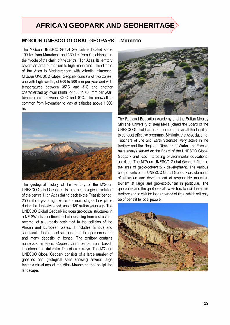
The M’Goun UNESCO Global Geopark is located some
100 km from Marrakech and 330 km from Casablanca, in
the middle of the chain of the central High Atlas. Its territory
covers an area of medium to high mountains. The climate
of the Atlas is Mediterranean with Atlantic influences.
M'Goun UNESCO Global Geopark consists of two zones,
one with high rainfall, of 600 to 900 mm per year and with
temperatures between 35°C and 3°C and another
characterized by lower rainfall of 400 to 700 mm per year,
temperatures between 30°C and 0°C. The snowfall is
common from November to May at altitudes above 1,500
m.
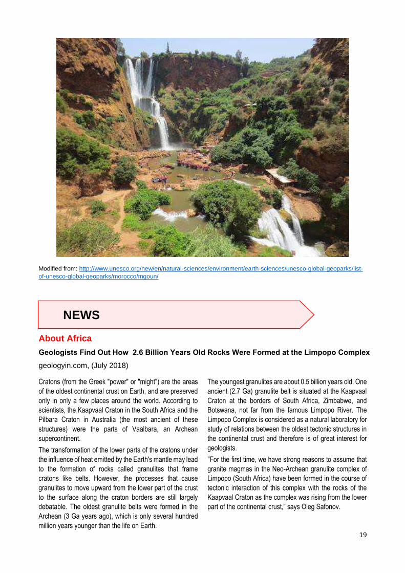
The geological history of the territory of the M'Goun
UNESCO Global Geopark fits into the geological evolution
of the central High Atlas dating back to the Triassic period,
250 million years ago, while the main stages took place
during the Jurassic period, about 180 million years ago. The
UNESCO Global Geopark includes geological structures in
a NE-SW intra-continental chain resulting from a structural
reversal of a Jurassic basin tied to the collision of the
African and European plates. It includes famous and
spectacular footprints of sauropod and theropod dinosaurs
and many deposits of bones. The territory contains
numerous minerals: Copper, zinc, barite, iron, basalt,
limestone and dolomitic Triassic red clays. The M'Goun
UNESCO Global Geopark consists of a large number of
geosites and geological sites showing several large
tectonic structures of the Atlas Mountains that sculpt the
landscape.
The Regional Education Academy and the Sultan Moulay
Slimane University of Beni Mellal joined the Board of the
UNESCO Global Geopark in order to have all the facilities
to conduct effective programs. Similarly, the Association of
Teachers of Life and Earth Sciences, very active in the
territory and the Regional Direction of Water and Forests
have always served on the Board of the UNESCO Global
Geopark and lead interesting environmental educational
activities. The M’Goun UNESCO Global Geopark fits into
the area of geo-biodiversity - development. The various
components of the UNESCO Global Geopark are elements
of attraction and development of responsible mountain
tourism at large and geo-ecotourism in particular. The
georoutes and the geotopes allow visitors to visit the entire
territory and to visit for longer period of time, which will only
be of benefit to local people.
19
Modified from: http://www.unesco.org/new/en/natural-sciences/environment/earth-sciences/unesco-global-geoparks/list-
of-unesco-global-geoparks/morocco/mgoun/
NEWS
About Africa
Geologists Find Out How 2.6 Billion Years Old Rocks Were Formed at the Limpopo Complex
geologyin.com, (July 2018)
Cratons (from the Greek "power" or "might") are the areas
of the oldest continental crust on Earth, and are preserved
only in only a few places around the world. According to
scientists, the Kaapvaal Craton in the South Africa and the
Pilbara Craton in Australia (the most ancient of these
structures) were the parts of Vaalbara, an Archean
supercontinent.
The transformation of the lower parts of the cratons under
the influence of heat emitted by the Earth's mantle may lead
to the formation of rocks called granulites that frame
cratons like belts. However, the processes that cause
granulites to move upward from the lower part of the crust
to the surface along the craton borders are still largely
debatable. The oldest granulite belts were formed in the
Archean (3 Ga years ago), which is only several hundred
million years younger than the life on Earth.
The youngest granulites are about 0.5 billion years old. One
ancient (2.7 Ga) granulite belt is situated at the Kaapvaal
Craton at the borders of South Africa, Zimbabwe, and
Botswana, not far from the famous Limpopo River. The
Limpopo Complex is considered as a natural laboratory for
study of relations between the oldest tectonic structures in
the continental crust and therefore is of great interest for
geologists.
"For the first time, we have strong reasons to assume that
granite magmas in the Neo-Archean granulite complex of
Limpopo (South Africa) have been formed in the course of
tectonic interaction of this complex with the rocks of the
Kaapvaal Craton as the complex was rising from the lower
part of the continental crust," says Oleg Safonov.

20
Granulite is a metamorphic rock. It means that it forms in
the course of transformation of other rocks under the
influence of high temperatures. In the case of granulites,
these temperatures are 750 to 1000 °C. Feldspars, quartz,
garnet, pyroxenes, cordierite and other minerals are formed
under these temperature giving the rock its granular
texture.
According to one of the models, an important role in the
formation of granulites is played by CO2-rich fluids heated
to over-critical temperatures. Graphite that is present in
metamorphic rocks may help establish whether this model
is true. Usually, graphite is formed in the course of
modification of organic matter or decomposition of
carbonates (salts of carbonic acid with CO32- anion).
However, granulites form at deep levels where no organic
matter is present, so the graphite formation mechanism is
different—graphite is the result of interaction of granulites
with mantle flows rich in CO2. Therefore, the presence of
graphite in granulites is often considered as an evidence for
this model. Its formation depends on pressure,
temperature, and other parameters, and the study of
graphite can tell a lot about them.
Geologists found graphite samples and fluid inclusions in
quartz (volatile components trapped in the small cavities of
minerals in the course of crystal growth) in granite rocks of
the Limpopo granulite belt and analyzed them.
The researchers found that granite rocks intruded the
Limpopo granulite belt began to crystallize at the
temperature of 900 to 940 °C and the pressure of 7 to 9
kbar. The analysis of fluid inclusions in quartz confirmed
that CO2-rich fluids took part in their formation. The
deviation of C-13 isotope content from standard values was
found to be 6.52 to 8.65 permille (tenth of percent) for
graphite and 2.5 to 5.58 permille for the fluids in quartz. This
isotopic composition of carbon is usually prescribed to deep
fluid flows from the mantle, confirming their external origin
once again.
This, in turn, coincides with the model of CO2-rich deep
external fluids participating in the formation of granulite
rocks and accompanying granites. However, having
compared this data with the isotopic composition of carbon
from the rocks of ancient cratons, the scientists concluded
that the fluids migrated through the Limpopo complex from
the cratonic rocks in the course of collision with the
Kaapvaal Craton.
While the study of the rocks in the Limpopo granulite
complex was of fundamental nature, the knowledge about
the processes of their formation may be used for ore
prospecting. "Rocks of ancient cratons are rich sources of
various ore components. They are carried by magmas and
fluids that originate in the course of transformation of these
rocks." comments Oleg Safonov.
The data about the formation of the South African granulite
complex is also relevant for Russia. The scientists plan to
compare their conditions with the data about the formation
of granulites in the Lapland belt that is situated between the
Karelian Craton and the Inari Craton at the border between
Russia and Finland.
This story originally appeared on
http://www.geologyin.com/2018/07/geologists-find-out-
how-over-26-ga.html
News: About Africa
Sahara Dust May Make You Cough, But It’s A Storm Killer
By Keith Randall, Texas A&M Marketing and Communications
The bad news: Dust from the Sahara Desert in Africa –
totaling a staggering 2 to 9 trillion pounds worldwide – has
been almost a biblical plague on Texas and much of the
Southern United States in recent weeks. The good news:
the same dust appears to be a severe storm killer.
Research from a team of scientists led by Texas A&M
University has studied Saharan dust and their work is
published in the current issue of the Journal of Climate of
AMS (American Meteorological Society).

21
Texas A&M’s Bowen Pan, Tim Logan, and Renyi Zhang in
the Department of Atmospheric Sciences analyzed recent
NASA satellite images and computer models and said the
Saharan dust is composed of sand and other mineral
particles that are swept up in air currents and pushed over
the Atlantic Ocean to the Gulf of Mexico and other nearby
regions.
As the dust-laden air moves, it creates a temperature
inversion which in turn tends to prevent cloud – and
eventually – storm formation.
On July 16, 2003, the Moderate Resolution Imaging
Spectroradiometer (MODIS) on the Aqua satellite captured
this image of a river of Saharan dust streaming out over the
Mediterranean Sea and northeastward to Italy. (NASA)
It means fewer storms and even hurricanes are less likely
to strike when the dust is present.
“The Saharan dust will reflect and absorb sunlight,
therefore reduce the sunlight at the Earth’s surface,” said
Pan.
“If we have more frequent and severe dust storms, it’s likely
that we have a cooler sea surface temperature and land
surface temperature. The storms have less energy supply
from the colder surface therefore will be less severe.”
The study goes on to show that dust and storm formation
don’t mix.
“Our results show significant impacts of dust on the
radiative budget, hydrological cycle, and large-scale
environments relevant to tropical cyclone activity over the
Atlantic,” said Zhang.
“Dust may decrease the sea surface temperature, leading
to suppression of hurricanes. For the dust intrusion over the
past few days, it was obvious that dust suppressed cloud
formation in our area. Basically, we saw few cumulus
clouds over the last few days. Dust particles reduce the
radiation at the ground, but heats up in the atmosphere,
both leading to more stable atmosphere. Such conditions
are unfavorable for cloud formation.”
Zhang said that the chances of a hurricane forming tended
to be much less and “our results show that dust may reduce
the occurrence of hurricanes over the Gulf of Mexico
region.”
Logan said that recent satellite images clearly show the
Saharan dust moving into much of the Gulf of Mexico and
southern Texas.
“The movement of the dust is there,” Zhang said, “but
predictions of dust storms can be very challenging.”
This story originally appeared on
https://today.tamu.edu/2018/07/20/texas-am-study-
sahara-dust-may-make-you-cough-but-its-a-storm-killer/
News: About the World
Arctic sea ice decline driving ocean phytoplankton farther north
news.agu.org (October 2018)
Phytoplankton blooms that form the base of the marine food
web are expanding northward into ice-free waters where
they have never been seen before, according to new
research.
A new study based on satellite imagery of ocean color
reveals phytoplankton spring blooms in the Arctic Ocean,
which were previously nonexistent, are expanding
northward at a rate of 1 degree of latitude per decade.
Although blooms, or large explosions of phytoplankton, did
not previously occur in this area, phytoplankton were
present in the Arctic’s central basin at low biomass. The
study also found the primary productivity of the
phytoplankton, or the rate at which phytoplankton are
converting sunlight into chemical energy, is increasing
during the spring blooms.
The decline in Arctic sea ice over the past several decades
has made way for areas of open water where phytoplankton
can thrive, driving their northward expansion, according to
the study’s authors. The researchers are unsure what effect
this expansion will have on the food web, but the results
suggest the decline of ice cover is impacting marine
ecosystems in unforeseen ways.
If sea ice continues to decline, it could drive phytoplankton
spring blooms farther north and increase primary

22
productivity even more. These changes could affect the fate
of the Arctic Ocean as a carbon source or a carbon sink,
according to the study.
This true-color image, captured by the NOAA-20 satellite on
July 30, 2018, shows a large phytoplankton bloom in the
Barents Sea. Credit: NOAA Environmental Visualization
Laboratory
“If the ice pack totally disappears in summer, there will be
consequences for the phytoplankton spring bloom,” said
Sophie Renaut, a Ph.D. student at Laval University in
Quebec City, Canada, and lead author of the new study in
Geophysical Research Letters, a journal of the American
Geophysical Union. “We cannot exactly predict how it will
evolve, but we’re pretty sure there are going to be drastic
consequences for the entire ecosystem.”
Phytoplankton in the ecosystem
Phytoplankton are microscopic organisms that live in water,
consume carbon dioxide and release oxygen through
photosynthesis. In this process, they convert sunlight into
chemical energy. Phytoplankton form the base of the
marine food web, indirectly feeding everything from small
fish to multi-ton whales.
Phytoplankton growth depends on the availability of carbon
dioxide, sunlight, nutrients, water temperature and salinity,
water depth and grazing animals, according to the NASA
Earth Observatory. When conditions are ideal,
phytoplankton population growth can explode, or bloom.
While a bloom may last several weeks, the lifespan of an
individual phytoplankton is seldom more than a few days.
Phytoplankton in the Arctic Ocean typically bloom every
spring. In the past, phytoplankton blooms have been
virtually absent from the highest Arctic latitudes, because
these areas are usually covered by sea ice. In recent
decades sea ice has declined, breaking up earlier in the
spring or not forming at all in some areas of the Arctic.
In the new study, Renaut and her colleagues wanted to see
if recent sea ice declines have had any effect on spring
phytoplankton blooms. They used satellite observations of
ocean color—which provide estimates of phytoplankton
biomass and primary productivity—to track changes of the
blooms each spring from 2003 to 2013.
They found the spring blooms are expanding farther north
and increasing in primary productivity. In the spring and
summer months, net primary productivity in the Arctic
Ocean increased by 31 percent between 2003 and 2013,
according to the study. The researchers also found that
these blooms in the Barents and Kara Seas, north of
Russia, are expanding north at a rate of 1 degree of latitude
per decade.
Unexpected effects of sea ice decline
Sea ice melt occurring earlier in the season creates larger
open water areas that act as incubators for phytoplankton
growth and elongate their growing season, according to
Renaut.
The authors suspect spring blooms could someday extend
into the Arctic’s central basin, which encompasses almost
everything north of 80 degrees latitude. Primary
productivity, though, would likely remain low due to a lack
of nutrients. Less ice cover means spring blooms and
under-ice blooms may also have to compete for light and
nutrients, thus altering the flow of the marine ecosystem.
The results suggest a large change in this region, which has
never been free of ice cover.
Estimates of annual trends in daily flux of primary
productivity (PP) during the phytoplankton spring bloom
determined from satellite ocean color data. Green pixels
correspond to new phytoplankton spring blooms observed
since 2010. Credit: S. Renaut et al. 2018
“The polar regions—the Southern Ocean and the Arctic
Ocean—they’re really important because they play a critical
role in regulating the global climate,” Renaut said. “If sea
ice disappears completely in summer in the Arctic Ocean,

23
which is what we expect in some decades, it’s going to have
an impact on the ecosystem but also likely on the climate.”
Patricia Yager, professor of Marine Sciences at the
University of Georgia who was not involved with the new
study, said the earlier algal bloom growth they observed in
some areas could have considerable impacts if animals are
not yet ready to graze on the phytoplankton.
“Such a mismatch in time could cause major changes to the
Arctic food web, impacting not only the local animals and
the people who live there, but also the global population of
migrating animals who depend on these Arctic resources,”
Yager said. “What happens in the Arctic does not stay in
the Arctic.”
Cecile Rousseaux, a research scientist at the Universities
Space Research Association, who was not involved in the
new study, said the study advances research in this area
by investigating individual regions of the Arctic for
phytoplankton productivity, and represents evidence of the
effects that reduced ice cover have on the biochemical
cycle of the Arctic Ocean. However, Rousseaux noted that
the study does have limitations.
“It is also important to remember that we are currently
limited by the amount of data available to study these
changes,” Rousseaux said. “Longer time series of satellite
data will allow us to confirm whether these trends in
phytoplankton productivity persist or not.”
This story originally appeared on
https://news.agu.org/press-release/arctic-sea-ice-decline-
driving-ocean-phytoplankton-farther-north/
News: About the World
Earth’s inner core is solid, 'J waves' suggest
By Australian National University
A new study by researchers at The Australian National
University (ANU) could help us understand how our planet
was formed.
Associate Professor Hrvoje Tkalčić and PhD Scholar Than-
Son Phạm are confident they now have direct proof that
Earth's inner core is solid.
They came up with a way to detect shear waves, or "J
waves" in the inner core -- a type of wave which can only
travel through solid objects.
"We found the inner core is indeed solid, but we also found
that it's softer than previously thought," Associate Professor
Tkalčić said.
"It turns out -- if our results are correct -- the inner core
shares some similar elastic properties with gold and
platinum. The inner core is like a time capsule, if we
understand it we'll understand how the planet was formed,
and how it evolves."
Inner core shear waves are so tiny and feeble they can't be
observed directly. In fact, detecting them has been
considered the "Holy Grail" of global seismology since
scientists first predicted the inner core was solid in the
1930s and 40s.
So the researchers had to come up with a creative
approach.
Their so-called correlation wavefield method looks at the
similarities between the signals at two receivers after a
major earthquake, rather than the direct wave arrivals. A
similar technique has been used by the same team to
measure the thickness of the ice in Antarctica.
View of Earth from space, showing North Africa, Europe
and the Middle East. Elements of this image furnished by
NASA.
"We're throwing away the first three hours of the
seismogram and what we're looking at is between three and
10 hours after a large earthquake happens. We want to get
rid of the big signals," Dr Tkalčic said.

24
"Using a global network of stations, we take every single
receiver pair and every single large earthquake -- that's
many combinations -- and we measure the similarity
between the seismograms. That's called cross correlation,
or the measure of similarity. From those similarities we
construct a global correlogram -- a sort of fingerprint of the
Earth."
The study shows these results can then be used to
demonstrate the existence of J waves and infer the shear
wave speed in the inner core.
While this specific information about shear waves is
important, Dr Tkalčić says what this research tells us about
the inner core is even more exciting.
"For instance we don't know yet what the exact temperature
of the inner core is, what the age of the inner core is, or how
quickly it solidifies, but with these new advances in global
seismology, we are slowly getting there.
"The understanding of the Earth's inner core has direct
consequences for the generation and maintenance of the
geomagnetic field, and without that geomagnetic field there
would be no life on the Earth's surface."
The research has been published in the journal Science.
Journal References:
Hrvoje Tkalčić, Thanh-Son Phạm. Shear properties of
Earth’s inner core constrained by a detection of J
waves in global correlation wavefield. Science,
2018; 362 (6412): 329 DOI:
10.1126/science.aau7649
This story appeared on https://www.sciencedaily.com/releases/2018/10/181019135124.htm
News: About the World
Earthquakes Can Systematically Trigger Other Ones on Opposite Side of Earth
Source University of Cambridge
New research shows that a big earthquake can not only
cause other quakes, but large ones, and on the opposite
side of the Earth.
The findings, published today in Scientific Reports, are an
important step toward improved short-term earthquake
forecasting and risk assessment.
Scientists at Oregon State University looked at 44 years of
seismic data and found clear evidence that tremblors of
magnitude 6.5 or larger trigger other quakes of magnitude
5.0 or larger.
It had been thought that aftershocks -- smaller magnitude
quakes that occur in the same region as the initial quake as
the surrounding crust adjusts after the fault perturbation --
were the only seismic activity an earthquake could lead to.
But the OSU analysis of seismic data from 1973 through
2016 -- an analysis that excluded data from aftershock
zones -- provided the first discernible evidence that in the
three days following one large quake, other earthquakes
were more likely to occur.
Each test case in the study represented a single three-day
window "injected" with a large-magnitude (6.5 or greater)
earthquake suspected of inducing other quakes, and
accompanying each case was a control group of 5,355
three-day periods that didn't have the quake injection.
"The test cases showed a clearly detectable increase over
background rates," said the study's corresponding author,
Robert O'Malley, a researcher in the OSU College of
Agricultural Sciences. "Earthquakes are part of a cycle of
tectonic stress buildup and release. As fault zones near the
end of this seismic cycle, tipping points may be reached
and triggering can occur."
The higher the magnitude, the more likely a quake is to
trigger another quake. Higher-magnitude quakes, which
have been happening with more frequency in recent years,
also seem to be triggered more often than lower-magnitude
ones.
A tremblor is most likely to induce another quake within 30
degrees of the original quake's antipode -- the point directly
opposite it on the other side of the globe.

25
"The understanding of the mechanics of how one
earthquake could initiate another while being widely
separated in distance and time is still largely speculative,"
O'Malley said. "But irrespective of the specific mechanics
involved, evidence shows that triggering does take place,
followed by a period of quiescence and recharge."
Earthquake magnitude is measured on a logarithmic 1-10
scale -- each whole number represents a 10-fold increase
in measured amplitude, and a 31-fold increase in released
energy.
The largest recorded earthquake was a 1960 temblor in
Chile that measured 9.5. The 2011 quake that ravaged the
Fukushima nuclear power plant in Japan measured 6.6.
In 1700, an approximate magnitude 9.0 earthquake hit the
Cascadia Subduction Zone -- a fault that stretches along
the West Coast of North American from British Columbia to
California.
Collaborating with O'Malley were Michael Behrenfeld of the
College of Agricultural Sciences, Debashis Mondal of the
College of Science and Chris Goldfinger of the College of
Earth, Ocean and Atmospheric Sciences.
This story appeared on geologyin.com,
https://www.geologyin.com/2018/08/earthquakes-can-
systematically-
trigger.html?fbclid=IwAR2ewzJcxBKGuDytVnwnmPdMNk
QyHpHDsqXw34SKc_5nB7zNjnE5eU4otpQ
News: About the World
Quake split a tectonic plate in two, and geologists are shaken
An intense temblor in Mexico was just the latest example of an enigmatic type of earthquake with highly destructive
potential
By Robin George Andrews (October 2018)
In September 7, 2017, a magnitude 8.2 earthquake struck
southern Mexico, killing dozens and injuring hundreds.
While earthquakes are common enough in the region, this
powerful event wasn’t any run-of-the-mill tremor.
That’s because part of the roughly 37-mile-thick tectonic
plate responsible for the quake completely split apart, as
revealed by a new study in Nature Geoscience. This event
took place in a matter of tens of seconds, and it coincided
with a gargantuan release of energy.
“If you think of it as a huge slab of glass, this rupture made
a big, gaping crack,” says lead author Diego Melgar, an
assistant professor of earthquake seismology at the
University of Oregon. “All indications are that it has broken
through the entire width of the thing.”
Such colossal fragmentation events have been observed
before in a handful of places around the world, and all these
epic earthquakes have one thing in common: No one really
knows how they happen. This information gap matters,
because huge populations from the western seaboard of
the Americas to the eastern shores of Japan could be
threatened by these enigmatic earthquakes.
For one thing, the deep quakes can induce strong shaking
over a wide area that can level plenty of multistory
buildings. One that took place beneath the Chilean town of
Chillán in 1939, for example, killed at least 30,000 people.
And when they happen near an ocean coastline, their
destructive potential could be magnified.
“My real worry over these kinds of events is the tsunami,”
Melgar says.
Buildings sit in shambles after a powerful September 2017
earthquake devastated Mexico's southern coast.
World’s most elusive earthquakes
Tectonic plates, also known as lithospheric slabs, are made
up of the planet’s crust and the hot-but-solid upper mantle.
They constantly move around Earth’s surface, either
grinding side by side, crumpling up into one another and
forming mountains, or descending under another plate in
what is referred to as a subduction zone.
Along these various plate boundaries, you get earthquakes
when friction generates stress that’s ultimately released.
But quakes can also occur far from these plate boundaries,
in the part of the slab that’s been pushed through a

26
subduction zone and into the lower mantle. (Here’s what
will happen when Earth’s tectonic plates grind to a halt.)
“If you bend an eraser, you can see the top half being
extended and stretched, whereas the bottom bit is
squashed and compressed,” Melgar notes. The same
applies to these slabs. This bending can activate faults
within the slab and trigger what are known as intraslab
earthquakes.
Intraslab quakes are happening all the time at low to
moderate magnitudes, often on faults involving side-to-side
movement or the upward push of a block. On occasion,
some incredibly energetic ones happen on so-called normal
faults, where the movement of a chunk of rock follows
gravity’s lead as it falls downward.
Melgar points to the 1933 Sanriku earthquake in Japan,
which came in at a magnitude 8.5, as a good example of
one of these intraslab normal quakes. Another would be the
magnitude 7.8 Tarapaca earthquake in northern Chile in
2005. Sometimes, as in southern Mexico, the rupture can
cut right through a slab. The same is thought to have
happened beneath Iran in 2013 during a magnitude 7.7
tremor.
The hotel 'Ane Centro' was damaged after a 8.2 magnitude
earthquake in Matias Romero, Oaxaca, Mexico.
Photograph by Angel Hernandez, EPA
Whether they feature this type of dramatic severance or
not, these powerful quakes are inherently mysterious.
Seismic surveys normally used to visualize tectonic
movements can’t penetrate to such depths. The mapping
of oceanic slabs is also in its infancy, and there’s not much
high-resolution historical data to go on. That means
geoscientists are currently scrambling for ways to best
explain what’s going on.
Plate tectonics pandemonium
The new study’s geophysical measurements and models
found that the Tehuantepec quake in Mexico was even
more bizarre than any of the others. Normal faults can only
rupture where the slab is being extended within the
shallower segments. The Tehuantepec quake rupture,
however, spread to even deeper parts of the slab that
should be compressed.
This is potentially solvable. The paper suggests that the
slab is being pulled down by its own weight so effectively
that gravity is creating a major extensional force. This
trumps the expected compressional forces, thereby
allowing normal faulting to take place.
Far more problematic is the rupture’s staggering reach,
which extended to a depth of around 47 miles. At this point,
temperatures exceed 2,012°F, hot enough to permit the
rocky slab to act more like a mushier plastic. A quake like
Tehauntepec requires rock to be cooler and therefore
harder, so it can break in a more brittle way.
Powerful normal fault earthquakes can take place in deep-
ish parts of slabs, says study coauthor Emmanuel Garcia,
a tectonics expert at Kyoto University. However, this only
really applies to truly ancient tectonic plates that have had
many millions of years to cool down, which makes them
more prone to break in a brittle fashion.
The Tehauntepec quake involved the Cocos plate, which is
a relatively young 25 million years old and is somewhat
warmer than plenty of other tectonic plates. That, according
to Melgar, makes the 2017 slab-splitting tremor “unheard
of.”
“Something funny is going on with the slab in Mexico,” says
Eric Fielding, a geophysicist at NASA’s Jet Propulsion
Laboratory who coauthored a paper on the 2013 Iran
quake.
Making a break for it
Part of the solution, according to Melgar’s team, may
involve deep water. As the Cocos slab heads into the
subduction zone under the North American plate, it bends
and cracks. This creates normal faults, which take in
seawater. As the slab passes into and through the
subduction zone into the lower mantle, it warms up and
dehydrates. This dehydration creates mechanical
weaknesses and can cause brittle fracturing, creating small
quakes or, perhaps, a huge one. The same theory was
applied to the 2013 Iran and 2005 Chilean quakes.
The fact that the Cocos plate is younger and warmer could
have created a “perfect storm” of events, suggests Stephen
Hicks, a seismologist at the University of Southampton who
was not involved in the new research. The plate’s relative
warmth might mean that the vital dehydration process took
place quicker, creating brittle conditions and faults early on
that could eventually slip in a violent manner.
Melgar adds that when the oceanic Cocos plate first formed
at a fiery mid-ocean trench, its cooling pattern created little

27
hills and valleys in its rock. These imperfections may have
eventually formed zones of weaknesses that could have
generated the Tehuantepec earthquake, making this a
story of destruction tens of millions of years in the making.
However, he notes, it still seems curious that brittle
fracturing could take place so spectacularly at such hellishly
hot depths. The slab could be oddly cold or made up of
some strange rocks, he suggests, but both ideas go against
what scientists expect conditions down there to be like.
Either way, figuring out the root cause of intraslab normal
quakes is more than just an intellectual endeavour.
Whether they are shallow or deep, these tremors can be
powerful enough to suddenly shift any seafloor nearby,
pushing vast quantities of water forward and creating
tsunamis.
The Tehauntepec tremor took place on the landward side
of the subduction zone, so the seafloor wasn’t deformed
enough to create more than a 10-foot tsunami. By contrast,
the 1933 Sanriku quake took place on the oceanward side
of the subduction zone and created a devastating 66-foot
tsunami.
When it comes to these strange, destructive earthquakes,
“we don’t truly know what’s happening, to be honest,” says
Hicks. But it’s clear that solving this titanic mystery could
one day be a life-saver.
This story appeared on nationalgeographic.com
https://www.nationalgeographic.com/science/2018/10/new
s-tectonic-plate-split-earthquakes-tsunamis-geology/
News: About Space/Astronomy
When white dwarf meets brown dwarf, POW!
By Deborah Byrd in Space (October 14, 2018)
In 1670, skywatchers saw a nova, a star that appeared
where none had been before. Today’s astronomers have
learned it was a collision between an aging white dwarf star,
and less massive brown dwarf.
Astronomers now think this hourglass-shaped image of the
object known as CK Vulpeculae is the result of a collision of
a brown dwarf and a white dwarf. Image via ALMA
(ESO/NAOJ/NRAO)/S. P. S. Eyres
In the 1600s, western astronomers were just emerging from
centuries of medieval thought, when the heavens were
thought to be unchanging. You can imagine their
astonishment when – in July of 1670, in what had been a
blank, dark sky – some observers witnessed a bright
pinprick of light that appeared, faded, reappeared, and then
disappeared entirely from view. At that time, astronomers
called such an event a nova or new star. This one was
located in front of the constellation Cygnus the Swan and
so received the name Nova sub Capite Cygni (a New Star
below the Head of the Swan). Modern astronomers have
learned it wasn’t a new star. It wasn’t even a spectacular
collision of two main-sequence stars, as announced in
2015. Instead, using data from the ALMA telescope in
Chile, astronomers now believe the event was a collision
between an aging white dwarf star and a brown dwarf (star
with too little mass to ignite thermonuclear fusion and
thereby shine as most stars do).
The object in question is now called CK Vulpeculae.
The new work is based on observations with the Atacama
Large Millimeter/submillimeter Array (ALMA) in northern
Chile. The astronomers studied the debris from this
explosion, which takes the form of dual rings of dust and
gas resembling an hourglass with a compact central object
(see image at top). Sumner Starrfield of Arizona State
University is a co-author on a paper published in the peer-
reviewed journal Monthly Notices of the Royal Astronomical
Society. He said in a statement:
It now seems what was observed centuries ago was not
what we would today describe as a classic ‘nova.’ Instead,
it was the merger of two stellar objects, a white dwarf and
a brown dwarf. When these two objects collided, they
spilled out a cocktail of molecules and unusual isotopes,
which gave us new insights into the nature of this object.
How did they conclude that the collision was between a
white dwarf and a brown dwarf, and not two main-sequence
stars, as had been reported earlier? They did it by studying
the light from two more-distant stars, shining behind the the
dusty remains of the merger. These studies let the
astronomers detect the telltale signature of the element
lithium, which is easily destroyed in the interior of a main

28
sequence star, but not inside a brown dwarf. Astronomer
Stewart Eyres of the University of South Wales
(@astrostewey on Twitter) and lead author on the paper
explained:
The presence of lithium, together with unusual isotopic
ratios of the elements carbon, nitrogen and oxygen point to
material from a brown dwarf star being dumped on the
surface of a white dwarf. The thermonuclear ‘burning’ and
an eruption of this material resulted in the hourglass we see
today.
According to the researchers, the white dwarf would have
been about 10 times more massive than the brown dwarf,
though much smaller in size. As the brown dwarf spiraled
inward, intense tidal forces exerted by the white dwarf
would have ripped it apart. Starrfield remarked:
This is the first time such an event has been conclusively
identified.
Bottom line: In 1670, skywatchers saw a nova, a star that
appeared where none had been before. Today’s
astronomers have learned it was a collision between an
aging white dwarf star, and less massive brown dwarf.
The constellation Cygnus the Swan, with Vulpecula. Image
via SkyTonight.org.
This story appeared on earthsky.org, (14 October 2018)
https://earthsky.org/space/when-white-dwarf-meets-
brown-dwarf
News: About Space/Astronomy
Asteroid Phaethon breaks all the rules. It acts like a comet, it supplies particles to a meteor
shower. Oh, and it’s blue
By Matt Williams (October 2018)
Having studies countless asteroids in near-Earth space,
astronomers have come to understand that the majority of
these rocks fall into one of two categories: S-type (grey)
and C-type (red). These are defined by the types of
materials on their surfaces, with S-type asteroids being
primarily composed of silicate rock and C-type asteroids
being made up of carbon materials.
However, there is also what are known as blue asteroids,
which make up only a fraction of all known Near-Earth
Objects (NEO). But when an international team
astronomers observed the blue asteroid (3200) Phaeton
during a flyby of Earth, they spotted behavior that was more
consistent with a blue comet. If true, then Phaeton is of a
class of objects that are so rare, they are almost unheard
of.
As they stated during the course of the presentation, the
team analyzed data from NASA’s Infrared Telescope
Facility (located atop Mauna Kea in Hawaii) and the
Smithsonian Astrophysical Observatory’s Tillinghast
telescope, which is located on Mount Hopkins in Arizona.
What they found was that Phaeton’s appearance and
behavior indicate that it has the characteristics of both an
asteroid and a comet.
This diagram shows the highly eccentric orbit of 3200
Phaethon. Credit: NASA JPL
For instance, like all asteroids, Phaeton is known to reflect
more light in the blue part of the spectrum than other
classes (hence the name). However, Phaeton sets itself

29
apart by being one of the bluest, and having the same color
over all of its surface. This is an indication that it may have
recently been uniformly heated by the Sun.
“Interestingly, we found Phaethon to be even darker than
had been previously observed, about half as reflective as
Pallas,” Kareta said. “This makes it more difficult to say how
Phaethon and Pallas are related.”
Its orbit is also one of the very eccentric, taking it so close
to the Sun that it reaches temperatures of up to about 800
°C (1500 °F). Similarly, it appears like an asteroid in the sky
(as a small dot versus a cloudy blotch), but also releases a
tiny tail of dust when it gets closest to the sun. This is a
indication that Phaeton’s composition includes volatile
elements (such as water, carbon dioxide, methane,
ammonia, etc.) that sublimate as it warms.
The 2015 Geminids over the LAMOST observatory in
China. Image credit and copyright: SteedJoy
Lastly, Phaeton is thought to be the “parent body” of the
annual Geminid meteor shower because of how its orbit is
similar to those of the Geminid meteors. Prior to Phaeton’s
discovery in 1983, scientists believed that all meteor
showers were due to active comets. As Kareta explained:
“At the time, the assumption was that Phaethon probably
was a dead, burnt-out comet, but comets are typically red
in color, and not blue. So, even though Phaeton’s highly
eccentric orbit should scream ‘dead comet,’ it’s hard to say
whether Phaethon is more like an asteroid or more like a
dead comet.”
This kind of activity has only been seen twice in the history
of astronomical observations, with Phaeton and one similar
object that defies classification as either an asteroid or a
comet. For these reasons, the research team theorizes that
Phaeton might be related to, or have broken off from, (2)
Pallas, one of the larger objects in the Main Asteroid Belt
(and also a blue asteroid).
Currently, the team is conducting observations of 2005 UD,
another small blue asteroid which may related to Phaethon.
By determining if it and Phaethon share the same
properties, they will gain valuable insight into what this
comet/asteroid’s true nature is. In addition, the study may
have implications on future asteroid-rendezvous missions,
like the Japanese Aerospace Exploration Agency’s (JAXA)
DESTINY+ technology demonstrator.
Artist’s impression of JAXA’s Demonstration and
Experiment of Space Technology for INterplanetary
voYage, Phaethon fLyby with reUSable (DESTINY+) probe
. Credit: JAXA
This mission, which stands for Demonstration and
Experiment of Space Technology for INterplanetary
voYage, Phaethon fLyby with reUSable probe, is scheduled
to conduct a flyby with several NEOS, including Phaeton,
after launching in 2022. The purpose of this mission will be
investigate the origin and nature of cosmic dusts, which are
key sources of organic compounds on Earth – and
therefore intrinsic to life.
In addition, the demonstrator will observe dust from
Phaeton and map its surface to gain a better understanding
of the mechanisms behind dust ejection. In this respect, this
mission could help us to better understand the differences
between comets and asteroids. Moreover, the highly
unique object it will study could help us to better understand
the origins of life in our Solar System.
The work was funded by the NASA Near-Earth Object
Observation program (NEOO) grant. In addition to Karten,
the team included multiple members of the LPL, the NASA
Johnson Space Center, the Planetary Exploration
Research Center at the Chiba Institute of Technology, and
the Planetary Science Institute (PSI).
This story appeared on universetoday, (25 October 2018)
https://www.universetoday.com/140357/asteroid-
phaethon-breaks-all-the-rules-it-acts-like-a-comet-it-
supplies-particles-to-a-meteor-shower-oh-and-its-
blue/?fbclid=IwAR2FFwzqK6JXLjNwmdOYdhPwFtHrq4Vb
ut3NTo2iB0czhtIDcFhK24ETZoI

30
GEOETHICS
Asteroid mining might actually be better for the environment
The first study of its environmental impact suggests that extracting resources such as platinum from asteroids might be
cleaner than doing so on Earth.
By Emerging Technology from the arXiv (October, 2018)
A certain kind of investor, asteroid mining is a path to untold
riches. Astronomers have long known that asteroids are
rich in otherwise scarce resources such as platinum and
water. So an obvious idea is to mine this stuff and return it
to Earth—or, in the case of water, to a moon base or Earth-
orbiting space station.
There is no shortage of interest in these ventures. In the
last decade, investors have funded half a dozen companies
that have set their sights on various nearby rocks. To many
observers, it’s only a matter of time before such a mission
gets the green light.
But profit margins are only part of the picture. A potentially
more significant aspect of these missions is the impact they
will have on Earth’s environment. But nobody has assessed
this environmental impact in detail.
Today, that changes thanks to the work of Andreas Hein
and colleagues at the University of Paris-Saclay in France.
These guys have calculated the greenhouse-gas emissions
from asteroid-mining operations and compared them with
the emissions from similar Earth-based activities. Their
results provide some eyebrow-raising insights into the
benefits that asteroid mining might provide.
The calculations are relatively straightforward. Rocket
launches release significant amounts of greenhouse gases
into the atmosphere. The fuel on board the first stage of a
rocket burns in Earth’s atmosphere to form carbon dioxide.
For kerosene-burning rockets, one kilogram of fuel creates
three kilograms of CO2. (The second and third stages
operate outside the Earth’s atmosphere and so can be
ignored.)
Reentries are just as damaging. That’s because a
significant mass of a re-entering vehicle ablates in the
upper atmosphere, producing NOx such as nitrous oxide
(N2O), a greenhouse gas that is about 300 times more
potent than CO2. By one estimate, the space shuttle
released about 20% of its mass in the form of N2O every
time it returned to Earth.
Hein and co use these numbers to calculate that a kilogram
of platinum mined from an asteroid would release some 150
kilograms of CO2 into Earth’s atmosphere. However,
economies of scale from large asteroid-mining operations
could lower this to about 60 kilograms of CO2 per kilogram
of platinum.
That needs to be compared with the emission from Earth-
based mining. Here, platinum mining generates significant
greenhouse gases, mostly from the energy it takes to
remove this stuff from the ground.
Indeed, the numbers are huge. The mining industry
estimates that producing one kilogram of platinum on Earth
releases around 40,000 kilograms of carbon dioxide. “The
global warming effect of Earth-based mining is several
orders of magnitude larger,” say Hein and co.
The figures for water are also encouraging. In this case, the
authors calculate the greenhouse-gas emissions from an
asteroid-mining operation that returns water to anywhere
within the moon’s orbit, a so-called cis-lunar orbit. They
compare this to the emissions from sending the same
volume of water from Earth into orbit.
The big difference is that a water-carrying vehicle from
Earth can haul only a small percentage of its mass as water.
But an asteroid-mining spacecraft can transport a
significant multiple of its mass as water to cis-lunar orbit.
“Substantial savings in greenhouse gas emissions can be
achieved,” say Hein and co.
This interesting work should help to focus minds on the
environmental impacts of mining, which are rapidly
increasing in profile. But it is only a first step. There is
significant uncertainty in the numbers here, so these will
need to be better understood.
Other factors will also eventually need to be taken into
account. The Earth-bound mining industry could become
more environmentally friendly by using renewable energy
rather than burning coal to generate power (as it does in
South Africa). Rocket launching could also become greener
if more eco-friendly fuels are developed. Both these things
would change the numbers.
There are also emissions that this analysis does not take
into account. For example, it does not include the emissions
from mission control on Earth or from launch-pad
construction. Then there are the ongoing effects of rocket
launches on the ozone layer, which also need to be
considered.

31
So there is more work to be done. But Hein and co have
taken a significant first step toward realistic environmental
life-cycle assessments for asteroid mining, a task that will
surely become more pressing as this industry matures.
This story appeared on technologyreview.com, (19 October
2018)
https://www.technologyreview.com/s/612311/asteroid-
mining-might-actually-be-better-for-the-
environment/?utm_medium=social&utm_source=facebook
.com&utm_campaign=owned_social&fbclid=IwAR3yOETy
GiYlAKwnkKE7jkiXClxNNHBq9tDl7NNQcEvrRjLdYcmydtS
N7SY
GEOETHICS
The Trump administration knows the planet is going to boil. It doesn't care
Trump’s team used few weeks ago to sneak in disastrous, linked policies on climate change and child refugee camps
By Bill McKibben (October 2018)
In the cloud of toxic dust thrown up by the Kavanaugh
hearings last week, two new Trump initiatives slipped by
with less notice than they deserve. Both are ugly, stupid –
and they are linked, though in ways not immediately
apparent.
In the first, the administration provided the rationale for
scrapping President Obama’s automobile mileage
standards: because Trump’s crew now officially expects the
planet to warm by 4C. In the environmental impact
statement they say it wouldn’t make much difference to the
destruction of the planet if we all keep driving SUVs.
The Trump years are a fantasy land where we pretend we
can go on living precisely as in the past, unwilling even to
substitute electric SUVs for our gas guzzlers. Photograph:
Mandel Ngan/AFP/Getty Images
The news in that statement is that administration officials
serenely contemplate that 4C rise (twice the last-ditch
target set at the Paris climate talks). Were the world to
actually warm that much, it would be a literal hell, unable to
maintain civilizations as we have known them. But that’s
now our policy, and it apparently rules out any of the actions
that might, in fact, limit that warming. You might as well
argue that because you’re going to die eventually, there’s
no reason not to smoke a carton of cigarettes a day.
Meanwhile, reporters also discovered that the
administration has set up what can only be described as a
concentration camp near the Mexican border for detained
migrant children, spiriting them under cover of darkness
from the foster homes and small shelters across the nation
where they had been staying.
Not an extermination camp – these aren’t Nazis – but a
camp that literally concentrates this “problem” in one place:
a tent city in the middle of the desert. Schooling is not
available there, as it was in the shelters they came from;
instead the kids are given “workbooks that they have no
obligation to complete. Access to legal services is limited.”
That camp is linked to climate change because, first, it’s in
a desert. If you searched high and low across the North
American continent, you could barely find a place hotter
and drier than Tornillo, Texas, where in June the average
high is 96F and where, as one climate data source
succinctly puts it, “there is virtually no rainfall during the
year”.
But the link goes much deeper. Most of those migrants are
from Central America and Mexico, and they might as easily
be described as refugees fleeing gang violence (much of it
rooted originally in the US) and a changing climate.
Guatemala, El Salvador and Honduras first saw an
outbreak of coffee rust linked to higher nighttime
temperatures; the El Niño that began in 2015 led to years
of unprecedented drought. Deep new droughts this summer
wiped out more harvests: “total or partial loss of crops
means that subsistence farmers and their families will not
have enough food to eat or sell in coming months,” the UN’s
Food and Agriculture Organization warned. The author
Todd Miller, writing in the Nation, described meeting men
trying to jump a train in Guatemala headed north toward the
border. “When I asked why they were heading for the
United States, one responded simply, “No hubo lluvia.”
(“There was no rain.”)
This will, of course, get steadily worse in the years ahead –
every climate forecast shows deserts spreading and water
evaporating across the region. And of course more
migration will follow, in every corner of the world. The World
Bank predicts we may see 140 million climate migrants
before long, and given the chaos that even a million people

32
fleeing the (partially drought-fueled) crisis in Syria created,
we better come to grips. Some of that migration will be
internal – perhaps six million people will abandon their
coastal property in Florida alone, according to recent
reports. And much of it will be international, as people flee
because their lives depend on it.
Telling people to stay home is not an option – when there’s
no water, or when the floods come each year, or when the
sea rises into your kitchen, people have to leave. Period.
And telling people to stay home is not a moral option, either.
Because the climate chaos setting off waves of refugees is
born above all from the unconstrained migration of carbon
dioxide molecules from America over the last century. No
wall can prevent the exhaust from our armada of oversized
cars from raising the temperature in Mexico; if Guatemala
could ship its changed climate back north it doubtless
would, but it can’t. We have to realize that global warming
stems from the fact that we are a world without atmospheric
borders, where the people who have done the least to
cause the problem feel its horrors first and hardest. That’s
why, over the last half-decade, the environmental and
migrant-rights movement have grown ever closer.
The Trump years are a fantasy land where we pretend we
can go on living precisely as in the past, unwilling even to
substitute electric SUVs for our gas guzzlers, and able to
somehow insist that the rest of the world stay locked in
place as well. It’s impractical, it’s unfair, and when it ends
up with camps for kids in the desert it’s downright evil.
This story appeared on theguardian.com, (2 October 2018)
https://www.theguardian.com/commentisfree/2018/oct/02/t
rump-administration-planet-boil-refugee-
camps?CMP=fb_gu
LITERATURE
About Africa
Journal of African Earth Sciences (volume 146) Introduction to the Special Issue on the Precambrian Geology of Egypt in honour of Professor Mahmoud Fawzy El Ramly Mamdouh M. Abdeen, Abdelrahman Fowler, Baher El-Kaliouby, Reinhard O. Greiling
Pages 1-3
Knight of the Egyptian Eastern Desert; Prof. Mahmoud Fawzy El Ramly: From geosynclinal theory to plate tectonics Baher El Kaliouby, Mohamed Ragaie El Tahlawi, Mamdouh M. Abdeen Pages 4-14
Neoproterozoic formation and evolution of Eastern Desert continental crust – The importance of the infrastructure-superstructure transition Robert J. Stern Pages 15-27
Contrasting Pan-African structural styles at the NW margin of the Congo Shield in Cameroon Boniface Kankeu, Reinhard O. Greiling, Jean Paul Nzenti, Sylvestre Ganno, ... Joseph V. Hell Pages 28-47
The Feiran-Solaf metamorphic complex, Sinai, Egypt: Evidence for orthogonal or oblique tectonic convergence? A. Fowler, I.S. Hassen, M. Hassan Pages 48-65
Geochemistry and origin of alkaline granites at Wadi Umm Adawi-Yahmid area, south Sinai- Egypt N.I. Abd El Ghaffar, A.A. Ramadan Pages 66-77
Radioactivity and geochemical characteristics of post collision granites, west Wadi Murrah area, South Eastern Desert, Egypt A.H. El Afandy, Kh, M. Fawzy, H.M. Assran, E.K. Abu Zeid, J.B. El Shayip Pages 78-94
Garnierite-bearing serpentinite from the Central Eastern Desert of Egypt: A signature of paleo-weathering in the Arabian Nubian Shield? Mohamed M. Hamdy, Hamed Gamal El Dien, Mohamed A. Abd El-Wahed, Tomoaki Morishita Pages 95-117
Auriferous shear zones in the central Allaqi-Heiani belt: Orogenic gold in post-accretionary structures, SE Egypt Basem Zoheir, Ashraf Emam, Maher El-Amawy, Tamer Abu-Alam

33
Pages 118-131
Hydrothermal evolution of granitoid-hosted gold mineralization in gidami area: An example for orogenic-gold deposits in Egypt Mohamed Abd El Monsef, Marek Slobodník, Ibrahim A. Salem Pages 132-149
The genesis of fluorite veins in Gabal El Atawi granite, Central Eastern Desert, Egypt Khairiya M. Fawzy Pages 150-157
Continental intraplate volcanism in the Sinai subplate: The Oligo-Miocene basalts of the Gulf of Suez rift Mohammed Z. El-Bialy, Ibrahim H. Khalifa, Mohamed M. Omar
Pages 158-179
Integration of remote sensing technique and field data in geologic mapping of an ophiolitic suture zone in western Arabian Shield Karim W. Abdelmalik, Ali M.A. Abd-Allah Pages 180-190
Assessment of radioactivity levels and potential radiation health hazards of Madsus granites and associated dikes nearby and around Ruwisat village, South Sinai, Egypt Mohamed Th S. Heikal, Gulcan Top Pages 191-208
Occupational health hazards in the Sukari Gold Mine, Egypt Ragab ElSayed Rabeiy, Mohammed Ragaiei ElTahlawi, Gamal Yehia Boghdady Pages 209-216
Journal of African Earth Sciences (volume 147)
Geological setting of gold mineralisation of the Minvoul greenstone belt (Ntem complex, northern Gabon) Mario Iglesias-Martínez, José Antonio Espí, Ambroise Edou-Minko Pages 1-10
Long term groundwater balance and water quality monitoring in the eastern plains of Urmia Lake, Iran: A novel GIS based low cost approach Mehrdad Jeihouni, Ara Toomanian, Seyed Kazem Alavipanah, Saeid Hamzeh, Petter Pilesjö Pages 11-19
40Ar–39Ar ages from the Sabongari and Nana igneous complexes within the central part of the Cameroon Line (Central Africa) Emmanuel Njonfang, Marinella A. Laurenzi, Pauline Wokwenmendam Nguet, Domenico Cozzupoli Pages 20-27
Chemistry of volcanic soils used for agriculture in Brava Island (Cape Verde) envisaging a sustainable management Rosa Marques, Bruno J. Vieira, M. Isabel Prudêncio, João C. Waerenborgh, ... Fernando Rocha Pages 28-42
Implementation of potential field data to depict the structural lineaments of the Sinai Peninsula, Egypt Khalid S. Essa, Abdelmohsen G. Nady, Mohamed S. Mostafa, Mahmoud Elhussein Pages 43-53
New insights on structures and active faults in northeastern Tunisia (Utica-Mateur region) from a gravity analysis: Geodynamic implications Fatma Rabii, Chokri Jallouli, Kevin Mickus, Abdelkader Soumaya, ... Noureddine Ben Ayed Pages 54-67
Petrogenesis of ultramafic rocks of komatiitic composition from the Central Zone of the Limpopo Belt, South Africa: Evidence from O and H isotopes Tapabrato Sarkar, Elena O. Dubinina, Chris Harris, Wolfgang D. Maier, Hassina Mouri Pages 68-77
Morphologic change and evolution of Acarinina sibaiyaensis and its descendants during the earliest Eocene CIE/PETM interval in southern Egypt Khaled Abdel-Kader Ouda Pages 78-125

34
Perspectives on the use of growth rate patterns in fossil ectotherm bones to characterise ancient continental environments: Case study in Late Neogene sites from northern Chad (Djurab) Florian Lapalus, Olga Otero, Clarisse Nekoulnang Djetounako, Mahamat Adoum, ... Géraldine Garcia Pages 126-135
Upper lithospheric structure of the Dobi graben, Afar Depression from magnetics and gravity data Zelalem Demissie, Kevin Mickus, David Bridges, Mohamed G. Abdelsalam, Estella Atekwana Pages 136-151
Facies analysis and ichnology of a prograding river-dominated and wave-influenced deltaic deposit: The Nkporo Formation in the Itigidi-Ediba region of the Afikpo Sub-basin, south-eastern Nigeria A.W. Mode, O.C. Ekwenye, I.A. Oha, F.C. Onah Pages 152-168
Groundwater salinization process in the coastal aquifer Sidi Abed-Ouled Ghanem (Province of El Jadida, Morocco) Sara Mountadar, Abdelkader Younsi, Abdelkader Hayani, Mustapha Siniti, Soufiane Tahiri Pages 169-177
Lithostratigraphic characterization of the Upper Campanian – Maastrichtian succession in the Afikpo Sub-basin, southern Anambra Basin, Nigeria Anthony U. Okoro, Ezekiel O. Igwe Pages 178-189
Intensification of the polymetallic vein exploration by multivariate analysis and staged LINEST function at Glojeh deposit, NW Iran Farshad Darabi-Golestan, Ardeshir Hezarkhani Pages 190-198
Heavy metals and nitrate to validate groundwater sensibility assessment based on DRASTIC models and GIS: Case of the upper Niger and the Bani basin in Mali Aboubacar Modibo Sidibe, Lin Xueyu Pages 199-210
Stress transfer, aftershocks distribution and InSAR analysis of the 2005 Dahuieh earthquake, SE Iran Camellia Yazdanfar, Majid Nemati, Maryam Agh Ataby, Mahasa Roustaei, Faramarz Nilfouroushan Pages 211-219
Variations in terrigenous input into the eastern Equatorial Atlantic over 120ka: Implications on Atlantic ITCZ migration Akintoye E. Akinnigbagbe, Xiqiu Han, Weijia Fan, Yong Tang, ... Zhanghua Lou Pages 220-227
Facies, depositional environments, and sequence stratigraphy analysis of the upper Barremian-lower Aptian carbonates in the northeast Kelardasht, N Iran Mohammad Ali Kavoosi, Neda Ezoji Pages 228-242
Time dependent electrical resistivity tomography and seasonal variation assessment of groundwater around the Olushosun dumpsite Lagos, South-west, Nigeria Ameloko Anthony Aduojo, Elijah Adebowole Ayolabi, Akinmosin Adewale Pages 243-253
Contribution of integrated geophysical data in the structural characterization of the El Hamma graben zone (Southern Tunisia): Example of a pull-apart basin along the South Atlasic Fault Corridor Mouna Hassine, Wajih Bouzid, Chedly Abbes, Hajer Azaiez, Hakim Gabtni Pages 254-267
New fossils of the giant pholidosaurid genus Sarcosuchus from the Early Cretaceous of Tunisia Jihed Dridi Pages 268-280
The assessment of soil erosion risk, sediment yield and their controlling factors on a large scale: Example of Morocco Abdelali Gourfi, Lahcen Daoudi, Zhou Shi Pages 281-299
Groundwater quality assessment using water quality index and GIS technique in Modjo River Basin, central Ethiopia Nafyad Serre Kawo, Shankar Karuppannan Pages 300-311
Environmental isotopes and stochastic modeling study to evaluate Tabin and Sarchnar springs, Kurdistan region-Iraq

35
Diary Ali Mohammed Amin Al-Manmi Pages 312-321
Mineralogy, chemistry and rock mechanic parameters of katoite-bearing rock from the Hatrurim Basin, Israel Yevgeny Vapnik, Vyacheslav Palchik, Irina Galuskina, Kamila Banasik, Tomasz Krzykawski Pages 322-330
A giant pterosaur in the Early Cretaceous (Albian) of Tunisia David M. Martill, Nizar Ibrahim, Samir Bouaziz Pages 331-337
Effect of flash flood on trace metal pollution in the groundwater - Wadi Baysh Basin, western Saudi Arabia Jalal M. Basahi, Milad H.Z. Masoud, N. Rajmohan Pages 338-351
Depositional environments and sequence stratigraphy of a mixed siliciclastic-carbonate ramp: An example from the cenomanian to Turonian Galala Formation in the northern Eastern Desert, Egypt Zaki A. Abdel-Fattah, Mahmoud A. Kora, Soad A. Raafat Pages 352-373
New tephrostratigraphic data from Lake Emakat (northern Tanzania): Implications for the eruptive history of the Oldoinyo Lengai volcano Anna Balashova, Hannes B. Mattsson, Ann M. Hirt Pages 374-382
Oil-oil correlation, geochemical characteristics, and origin of hydrocarbons from Mansourabad oilfield, SW Iran Bahram Alizadeh, Khaled Maroufi, Mahdi Fajrak Pages 383-392
Enrichment of rare earth and radioactive elements concentration in accessory phases from alkaline granite, South Sinai- Egypt N.I. Abd El Ghaffar Pages 393-401
Geochemical characterisation of the <2 μm fractions of cretaceous-tertiary kaolins from eastern dahomey and Niger delta basins, Nigeria: Implications on paleoenvironment, provenance, and tectonic settings Olaonipekun Oyebanjo, Georges-Ivo Ekosse, John Odiyo Pages 402-410
New insights from microfauna associations characterizing palaeoenvironments, sea level fluctuations and a tsunami event along Sfax Northern coast (Gulf of Gabes, Tunisia) during the Late Pleistocene-Holocene Afef Khadraoui, Mohamed Kamoun, Asma Ben Hamad, Chahira Zaïbi, ... Fekri Kamoun Pages 411-429
Tectonomagmatic setting, petrography, petrochemistry and mineralography of the Divar Cu-Fe deposit in the Sistan Suture Zone, eastern Iran Houshang Pourkaseb, Alireza Zarasvandi, Mansour Adelpour, Masoud Hoseini Pages 430-442
Identifying the origin of groundwater salinisation in the Sidi El Hani basin (central-eastern Tunisia) M'nassri Soumaia, Dridi Lotfi, Lucas Yann, Schäfer Gerhard, ... Majdoub Rajouene Pages 443-449
Evolution of monogenetic rift-related alkaline magmatism in south Egypt: Insight from stratigraphy, geochronology, and geochemistry of the Natash volcanics Ezz El Din Abdel Hakim Khalaf, Takashi Sano, Yukiyasu Tsutsumi Pages 450-476
Zircon U-Pb age and geochemical constraints on the origin and tectonic implications of late cretaceous intra-oceanic arc magmatics in the Southeast Anatolian Orogenic Belt (SE-Turkey) Melahat Beyarslan, Ahmet Feyzi Bingöl Pages 477-497
Development of an empiric model of estimation of the environmental risk of soil physical degradation in the context of climate change application in the Mejerda valley, Tunisia R. Riahi, A. Hatira, S. Baccouche, A. Nakouri Pages 498-510

36
Tracing groundwater salinization processes in an inland aquifer: A hydrogeochemical and isotopic approach in Sminja aquifer (Zaghouan, northeast of Tunisia) Sabrine Mejri, Anis Chekirbene, Maki Tsujimura, Mabrouk Boughdiri, Ammar Mlayah Pages 511-522
Petrography and geochemistry of sandstones succession of the Qal'eh Dokhtar Formation (Middle-Upper Jurassic), east central Iran: Implications for provenance, tectonic setting and palaeoweathering Mahnaz Sabbagh Bajestani, Asadollah Mahboubi, Reza Moussavi-Harami, Mehdi Nadjafi Pages 523-535
Assessment of water quality and time accumulation of heavy metals in the sediments of tropical urban rivers: Case of Bumbu River and Kokolo Canal, Kinshasa City, Democratic Republic of the Congo John M. Kayembe, Periyasamy Sivalingam, Carmen Diz Salgado, Jeff Maliani, ... John Poté Pages 536-543
A subducted Neoproterozoic rift assemblage: The Egere Group (central Hoggar, Algeria) Renaud Caby, Olivier Bruguier Pages 544-553
U/Pb LA-SF-ICP-MS dating of detrital zircons in Cretaceous-Tertiary kaolins in the Douala Sub-Basin, Cameroon: A Neoproterozoic provenance Nenita Bukalo, Georges-Ivo Ekosse, John Odiyo, Jason Ogola Pages 554-568
The Paleocene/Eocene (P/E) boundary along the eastern plateau of Kharga-Baris oases, Western Desert, Egypt Amr A. Metwally, Kamel H. Mahfouz Pages 569-584
Structural interpretation of new high-resolution aeromagnetic and radiometric data over central Iran: Block definition and rotational tectonics Ian Basson, Reza Ravasan, Farzad Mahdavi, Yeganeh Hemmati, ... Jude King Pages 585-602
Palynological and palaeoenvironmental analyses of the upper Albian-Cenomanian succession in Gindi Basin, Egypt: Implication for transgressive/regressive systems tracts Ahmed Mansour, Sameh S. Tahoun Pages 603-622
Geochemistry and weathering history of the Balfour sandstone formation, Karoo basin, South Africa: Insight to provenance and tectonic setting Monica E. Oghenekome, Tapas K. Chatterjee, Jan M. van Bever Donker, Napoleon Q. Hammond Pages 623-632
Heavy mineral beach placers of the Ordovician Amdeh Formation (Member 4, Wadi Qahza, Saih Hatat, eastern Oman Mountains): Where is the main source area? Frank Mattern, Bernhard Pracejus, Lujaina Al Balushi Pages 633-646
Groundwater pollution potential evaluation in Khorramabad-Lorestan Plain, western Iran Hossein Yousefi, Ali Haghizadeh, Yazdan Yarahmadi, Parvin Hasanpour, Parvin Noormohamadi Pages 647-656
Planktonic foraminifera biozones and isotope stratigraphy of the Cenomanian-Turonian boundary in the western part of the Kopet-Dagh Basin, NE Iran Yadolah Ezampanah, Abbas Sadeghi, Giovanna Scopelliti, Mohammad Hossein Adabi, Amir Mohammad Jamali Pages 657-670
Journal of African Earth Sciences (volume 148)
Paleoproterozoic Birimian Geology for sustainable development Tahar Aïfa Pages 1-5
The Logoualé Band: A large Archean crustal block in the Kenema-Man domain (Man-Leo rise, West African Craton) remobilized during Eburnean orogeny (2.05 Ga) Alain Nicaise Kouamelan, Kouassi Serge Auguste Kra, Sagbrou Chérubin Djro, Jean-Louis Paquette, Jean-Jacques Peucat Pages 6-13

37
Thrust to transpression and transtension tectonics during the Paleoproterozoic evolution of the Birimian Greenstone Belt of Mako, Kédougou-Kéniéba Inlier, Eastern Senegal Moussa Dabo, Tahar Aïfa, Ibrahima Gassama, Papa Malick Ngom
Pages 14-29
Multi-scale distribution of Potassium. Thorium and Uranium in Paleoproterozoic granites from eastern Senegal Makhoudia Fall, David Baratoux, Papa Moussa Ndiaye, Mark Jessell, Lenka Baratoux Pages 30-51
Intrusion-related gold mineralization: Inata gold deposit, Bélahourou district, Northern Burkina Faso (West-Africa) Hermann Ilboudo, Sâga Sawadogo, Abraham Seydoux Traoré, Martial Sama, ... Martin Lompo Pages 52-58
The Belahourou granite pluton (Djibo greenstone belt, Burkina Faso): Emplacement mechanism and implication for gold mineralization along a shear zone Sâga Sawadogo, Séta Naba, Hermann Ilboudo, Abraham Seydoux Traoré, ... Martin Lompo Pages 59-68
Zircon U–Pb geochronology and Nd isotope systematics of the Guro Suite granitoids, Mozambique: Implications for Neoproterozoic crust reworking events Vicente Albino Manjate, Colombo Celso Gaeta Tassinari Pages 69-79
Petrography, lithostratigraphy and major element geochemistry of Mesoarchean metamorphosed banded iron formation-hosted Nkout iron ore deposit, north western Congo craton, Central West Africa Ekah Nzume Ndime, Sylvestre Ganno, Landry Soh Tamehe, Jean Paul Nzenti Pages 80-98
New models for geoscience higher education in West Africa Mark Jessell, David Baratoux, Luc Siebenaller, Kim Hein, ... El Hajdi Sow Pages 99-108
Journal of African Earth Sciences (volume 149) A geochemical approach to fossilization processes in Miocene vertebrate bones from Sahabi, NE Libya E. Margariti, E.T. Stathopoulou, Y. Sanakis, E. Kotopoulou, ... A. Godelitsas Pages 1-18
Sedimentologic and palaeoenvironmental evolution of the Mamfe Cretaceous Basin (SW Cameroon): Evidence from lithofacies analysis, tectonics and evaporite minerals suite John Takem Eyong, Ngueutchoua Gabriel, Bessong Moïse, Victor Joseph Hell, ... Jim Best Pages 19-41
Petrophysical and aquifer parameters estimation using geophysical well logging and hydrogeological data, Wadi El-Assiuoti, Eastern Desert, Egypt A.A. Farrag, M.O. Ebraheem, R. Sawires, H.A. Ibrahim, A.L. Khalil Pages 42-54
Depositional facies, diagenetic overprints and sequence stratigraphy of the upper Surmeh reservoir (Arab Formation) of offshore Iran Ebrahim Sfidari, Abdolhossein Amini, Ali Kadkhodaie-Ilkhchi, Ali Chehrazi, Seyed Mohammad Zamanzadeh Pages 55-71
Processes of water–rock interactions and their impacts upon the groundwater composition in Assiut area, Egypt: Applications of hydrogeochemical and multivariate analysis R.G.M. Ibrahim, E.A. Korany, R.N. Tempel, M.A. Gomaa Pages 72-83
First Bathonian (Middle Jurassic) nautiloid Paracenoceras Spath from Ethiopia Sreepat Jain Pages 84-96
Seismic anisotropy and mantle flow beneath East Africa and Arabia Ahmed A. Elsheikh Pages 97-108
Magmatic evolution of the Boku Volcanic Complex, Main Ethiopian Rift Amdemichael Z. Tadesse, Dereje Ayalew, Raphael Pik, Gezahegn Yirgu, Karen Fontijn Pages 109-130

38
Geochemical characteristics of shales in the Mamfe Basin, South West Cameroon: Implication for depositional environments and oxidation conditions Bokanda Ekoko Eric, Fralick Philip, Ekomane Emile, Njilah Isaac Konfor, ... Ekoa Bessa Armel Zacharie Pages 131-142
Geochemical and mineralogical evidence for the supergene origin of kaolin deposits – Central Main Ethiopian Rift Gemechu Bedassa, Worash Getaneh, Binyam Hailu Pages 143-153
Middle Eocene to early Oligocene dinoflagellate cyst biostratigraphy and paleoenvironmental interpretations of the Ben Attaya section at Taza, eastern External Rif, Morocco Imane Mahboub, Hamid Slimani, Abdelkabir Toufiq, Mouna Chekar, ... Sara Chakir Pages 154-169
Paleo-environmental reconstructions of the Upper Cretaceous-Paleogene successions, Safaga, Egypt Rania Abu-Ali, Ahmed El-Kammar, Ahmed Zakaria, Moataz El-Shafeiy, Jochen Kuss
Pages 170-193
A reworked elasmobranch fauna from Tunisia providing a snapshot of Eocene-Oligocene Tethyan faunas Simon Sweydan, Gilles Merzeraud, El Mabrouk Essid, Wissem Marzougui, ... Sylvain Adnet Pages 194-206
The depth estimation of subsurface anomalies using probability tomography imaging method from airborne vertical gravity gradient Ali Hamzeh, Mahmoud Mehramuz Pages 207-214
Eclogite facies metabasites from the Paleoproterozoic Nyong Group, SW Cameroon: Mineralogical evidence and implications for a high-pressure metamorphism related to a subduction zone at the NW margin of the Archean Congo craton M. Houketchang Bouyo, J. Penaye, H. Mouri, S.F. Toteu Pages 215-234
Calcareous nannofossil and planktonic foraminiferal Biostratigraphy of Santonian to Danian in Göynük Basin, Bolu, Turkey Caner Kaya Ozer, Ugur Temiz Pages 235-270
Seismotectonics of South Africa Brassnavy Manzunzu, Vunganai Midzi, Thifhelimbilu F. Mulabisana, Brian Zulu, ... Ganesh W. Rathod Pages 271-279
The structural re-interpretation of the Lower Shire Basin in the Southern Malawi rift using gravity data Chikondi Chisenga, Zuze Dulanya, Yan Jianguo Pages 280-290
The lower Maastrichtian chalk in the Ghezala-Mateur area, northern Tunisian domain: Sedimentary environments and early diagenetic features Fehmy Belghouthi, Hédi Zouari, Rekaya-Selwa Jeddi Pages 291-306
Cyclic hierarchy and depositional sequences of the Middle-Upper Eocene ramp facies: An example from Beni Suef area, east Nile Valley, Egypt Ahmed Wagih Hussein Pages 307-333
Drivers, patterns and velocity of saltwater intrusion in a stressed aquifer of the East African coast: Joint analysis of groundwater and geophysical data in southern Kenya Samson Oiro, Jean-Christophe Comte Pages 334-347
Petrography, mineralogy, geochemistry and genesis of the Balaya bauxite deposits in Kindia region, Maritime Guinea, West Africa Moussa Sidibe, Mustafa Gurhan Yalcin Pages 348-366
Characterization of the salinity conditions of Cenomanian formations based on sedimentological and ichnological data of selected cores from Ivoirian offshore basin (septentrional Gulf of Guinea)

39
Isaac Fea, Anne Mcafee, N'goran Jean-Paul Yao, Zeli Bruno Digbehi, ... Bakary Fofana Pages 367-397
The Pan-African post-collision Hosséré Mana plutonic complex and associated Gapi Stock (Western Cameroon Domain, Cameroon): Petrology, mineralogy and geochemistry Zénon Itiga, Bernard Bonin, Jacques-Marie Bardintzeff, Pierre Wandji, ... Hervé Bellon Pages 398-425
The Sukari Neoproterozoic granitoids, Eastern Desert, Egypt: Petrological and structural implications Haroun A. Mohamed, Shehata Ali, Tarek Sedki, Ismaiel I. Abdel Khalik Pages 426-440
Validating (MNF) transform to determine the least inherent dimensionality of ASTER image data of some uranium localities at Central Eastern Desert, Egypt Mahinaz M. Shawky, Reda A. El-Arafy, Mohamed A. El Zalaky, Taha Elarif Pages 441-450
Petrogenesis of the Early-Triassic quartz-monzodiorite dykes from Central Jebilet (Moroccan Meseta): Trace element and Nd-Sr isotope constraints on magma sources, and inferences on their geodynamic context Jacky Bouloton, Dominique Gasquet, Christian Pin Pages 451-464
Fluid inclusion and oxygen isotope studies in garnets related to Çavuşlu Skarn iron mineralization, East Turkey Mehmet Altunbey, Ayşe Didem Kiliç Pages 465-473
Sedimentary environmental conditions and petroleum source rock potential of the Late Jurassic Arwa Member shales in Al-Jawf sub-basin, Yemen Mohammed Hail Hakimi, Abdulwahab S. Alaug, Abdulghani F. Ahmed, Madyan M.A. Yahya Pages 474-486
Mineralogical and geochemical criteria to identify the origin and the depositional environment of the upper Numidian babouchite siliceous rocks, northwestern Tunisia N. Ben Yahia, A. Sebei, C. Harris, S. Boussen, F. Chaabani Pages 487-502
Facies and petrophysical modeling of the Upper Bahariya Member in Abu Gharadig oil and gas field, north Western Desert, Egypt Ahmed Abdelmaksoud, Ahmed T. Amin, Galal H. El-Habaak, Hatem F. Ewida Pages 503-516
Irrigation return flow induced mineral weathering and ion exchange reactions in the aquifer, Luvuvhu catchment, South Africa Vhonani G. Nethononda, Vetrimurugan Elumalai, Natarajan Rajmohan Pages 517-528
Earth-Science Reviews A data-based landslide susceptibility map of Africa Earth-Science Reviews, Volume 185, October 2018, Pages 102-121 Jente Broeckx, Matthias Vanmaercke, Rica Duchateau, Jean Poesen
Regional geological formation and speleogenesis of the Fossil Hominid Sites of South Africa: UNESCO World Heritage Area Earth-Science Reviews, In press, accepted manuscript, Available online 3 October 2018 Ashleigh Murszewski, Tara R. Edwards, Alexander R. Cruden, Brian Armstrong, Andy I. R. Herries
The Tuareg shield terranes revisited and extended towards the northern Gondwana margin: Magnetic and gravimetric constraints Earth-Science Reviews, Volume 185, October 2018, Pages 572-599 Sonia Brahimi, Jean-Paul Liégeois, Jean-François Ghienne, Marc Munschy, Amar Bourmatte
Archean-Paleoproterozoic transition: The Indian perspective Earth-Science Reviews, In press, accepted manuscript, Available online 23 November 2018 Rajat Mazumder, Shuvabrata De, P. V. Sunder Raju
Nature and assembly of microcontinental blocks within the Paleo-Asian Ocean Earth-Science Reviews, Volume 186, November 2018, Pages 76-93 Jian-Bo Zhou, Simon A Wilde, Guo-Chun Zhao, Jie Han

40
Provenance of Mesozoic to Cenozoic circum-Mediterranean sandstones in relation to tectonic setting Earth-Science Reviews, Volume 185, October 2018, Pages 624-648 Salvatore Critelli
Systematic review of geochemical data from thermal springs, gas vents and fumaroles of Southern Italy for geothermal favourability mapping Earth-Science Reviews, In press, corrected proof, Available online 20 September 2018 A. Minissale, A. Donato, M. Procesi, L. Pizzino, S. Giammanco
Insights into geological processes with CO2 remote sensing – A review of technology and applications Earth-Science Reviews, In press, accepted manuscript, Available online 26 November 2018 Manuel Queißer, Mike Burton, Ryunosuke Kazahaya
Ecological persistence, incumbency and reorganization in the Karoo Basin during the Permian-Triassic transition Earth-Science Reviews, In press, corrected proof, Available online 21 October 2018 Peter D. Roopnarine, K. D. Angielczyk, A. Weik, A. Dineen
Extensional crustal tectonics and crust-mantle coupling, a view from the geological record Earth-Science Reviews, Volume 185, October 2018, Pages 1187-1209 Laurent Jolivet, Armel Menant, Camille Clerc, Pietro Sternai, Christian Gorini
Geological reconstructions of the East Asian blocks: From the breakup of Rodinia to the assembly of Pangea Earth-Science Reviews, Volume 186, November 2018, Pages 262-286 Guochun Zhao, Yuejun Wang, Baochun Huang, Yunpeng Dong, Shan Yu
Major perturbations in the Earth's forest ecosystems. Possible implications for global warming Earth-Science Reviews, Volume 185, October 2018, Pages 544-571 Remus Prăvălie
Precambrian Research Transition from subduction to collision recorded in the Pan-African arc complexes (Mali to Ghana) Precambrian Research, Volume 320, January 2019, Pages 261-280 Stéphane Guillot, Yao Agbossoumondé, Jérôme Bascou, Julien Berger, Stéphane Schwartz
Northwest Africa’s Ediacaran to early Cambrian fossil record, its oldest metazoans and age constraints for the basal Taroudant Group (Morocco) Precambrian Research, Volume 320, January 2019, Pages 438-453 Dominik Letsch, Simon J. E. Large, Stefano M. Bernasconi, Christian Klug, Albrecht von Quadt
Neoarchean (2.7 Ga) lacustrine stromatolite deposits in the Hartbeesfontein Basin, Ventersdorp Supergroup, South Africa: Implications for oxygen oases Precambrian Research, Volume 320, January 2019, Pages 291-302 D. T. Wilmeth, F. A. Corsetti, N. J. Beukes, S. M. Awramik, A. J. Celestian
High-temperature metamorphism and crustal melting at ca. 3.2 Ga in the eastern Kaapvaal craton, southern Africa Precambrian Research, Volume 317, October 2018, Pages 101-116 A. Kröner, T. J. Nagel, J. E. Hoffmann, X. Liu, D. Liu
Rhyacian-Orosirian isotopic records from the basement of the Araçuaí-Ribeira orogenic system (SE Brazil): Links in the Congo-São Francisco palaeocontinent Precambrian Research, Volume 317, October 2018, Pages 179-195 Reik Degler, Antonio Pedrosa-Soares, Tiago Novo, Mahyra Tedeschi, Cristiano Lana
Neoproterozoic magmatic and metamorphic events in the Cuchilla Dionisio Terrane, Uruguay, and possible correlations across the South Atlantic Precambrian Research, Volume 320, January 2019, Pages 303-322 T. M. Will, C. Gaucher, X. -X. Ling, X. -H. Li, H. E. Frimmel
The 920–900 Ma Bahia-Gangila LIP of the São Francisco and Congo cratons and link with Dashigou-Chulan LIP of North China craton: New insights from U-Pb geochronology and geochemistry Precambrian Research, In press, corrected proof, Available online 31 August 2018 Alexandre de Oliveira Chaves, Richard E. Ernst, Ulf Söderlund, Xinping Wang, Tomas Naeraa
Igneous and detrital zircon U-Pb and Lu-Hf geochronology of the late Meso- to Neoproterozoic northwest Botswana rift: Maximum depositional age and provenance of the Ghanzi Group, Kalahari Copperbelt, Botswana and Namibia Precambrian Research, Volume 318, November 2018, Pages 133-155 Wesley S. Hall, Murray W. Hitzman, Yvette D. Kuiper, Andrew R. C. Kylander-Clark, M. Stephen Enders

41
Neoproterozoic sedimentary rocks track the location of the Lhasa Block during the Rodinia breakup Precambrian Research, Volume 320, January 2019, Pages 63-77 Xiang Zhou, Jianping Zheng, Yibing Li, William L. Griffin, Suzanne Y. O'Reilly
Geochronological characterization of a transition zone between the Mozambique Belt and Unango-Marrupa Complex in SE Tanzania Precambrian Research, In press, accepted manuscript, Available online 28 November 2018 Epiphania G. Mtabazi, Nelson Boniface, Arild Andresen
New constraints from detrital zircon ages on prolonged, multiphase transition from the Cadomian accretionary orogen to a passive margin of Gondwana
Precambrian Research, Volume 317, October 2018, Pages 159-178 Jaroslava Hajná, Jiří Žák, Wolfgang Dörr, Václav Kachlík, Jiří Sláma
The evolution of the Arabian-Nubian Shield and survival of its zircon U-Pb-Hf-O isotopic signature: A tale from the Um Had Conglomerate, central Eastern Desert, Egypt Precambrian Research, Volume 320, January 2019, Pages 46-62 Yasser Abd El-Rahman, Mohamed Abu Anbar, Xian-Hua Li, Jiao Li, Ahmed E. Masoud
First evidence of Archean mafic dykes at 2.62 Ga in the Yilgarn Craton, Western Australia: Links to cratonisation and the Zimbabwe Craton Precambrian Research, Volume 317, October 2018, Pages 1-13 J. Camilla Stark, Simon A. Wilde, Ulf Söderlund, Zheng-Xiang Li, Jian-Wei Zi
Ore Geology ReviewsRegional folding, low-angle thrusting and permeability networks: Structural controls of gold mineralization in the Hope reef at Fairview Mine, Barberton Greenstone Belt, South Africa Ore Geology Reviews, Volume 102, November 2018, Pages 585-603 Jonathan Gloyn-Jones, Alexander Kisters
Vein-type tungsten deposits in Rwanda, Rutsiro area of the Karagwe-Ankole Belt, Central Africa Ore Geology Reviews, Volume 102, November 2018, Pages 505-518 Thomas d'Aquin Tumukunde, Adam Piestrzynski
The rare metal deposits of the El Garra El Hamra syenites, South Western Desert, Egypt Ore Geology Reviews, Volume 101, October 2018, Pages 609-628 Soliman Abu Elatta A. Mahmoud
A review of the mineral potential of Liberia Ore Geology Reviews, Volume 101, October 2018, Pages 413-431 A. G. Gunn, J. K. Dorbor, J. M. Mankelow, P. A. J. Lusty, K. M. Goodenough
Multi-stage and multi-sourced fluid and gold in the formation of orogenic gold deposits in the world-class Mana district of Burkina Faso – Revealed by LA-ICP-MS analysis of pyrites and arsenopyrites Ore Geology Reviews, Volume 104, January 2019, Pages 495-521 Jérôme Augustin, Damien Gaboury
Petrology, geochemistry and stable isotope studies of the Miocene igneous rocks and related sulphide mineralisation of Oued Amizour (NE Algeria) Ore Geology Reviews, Volume 101, October 2018, Pages 312-329 Rabah Laouar, Abdelmalek Lekoui, Tayeb Bouima, Sihem Salmi-Laouar, Anthony E. Fallick
Geology of the Ngualla Carbonatite Complex, Tanzania, and origin of the Weathered Bastnaesite Zone REE ore Ore Geology Reviews, In press, accepted manuscript, Available online 6 December 2018 W. K. Witt, D. P. Hammond, M. Hughes
A pilot study to test the reliability of the ERT method in the identification of mixed sulphides bearing dykes: The example of Sidi Flah mine (Anti-Atlas, Morocco) Ore Geology Reviews, Volume 101, October 2018, Pages 819-838 Stefano Bernardinetti, Diego Pieruccioni, Enrico Mugnaioli, Franco Maria Talarico, Emanuele Tufarolo
Monitoring surface mining belts using multiple remote sensing datasets: A global perspective Ore Geology Reviews, Volume 101, October 2018, Pages 675-687 Le Yu, Yidi Xu, Yueming Xue, Xuecao Li, Peng Gong
On the origin of large type IIa gem diamonds Ore Geology Reviews, Volume 102, November 2018, Pages 195-203 Sergei K. Simakov
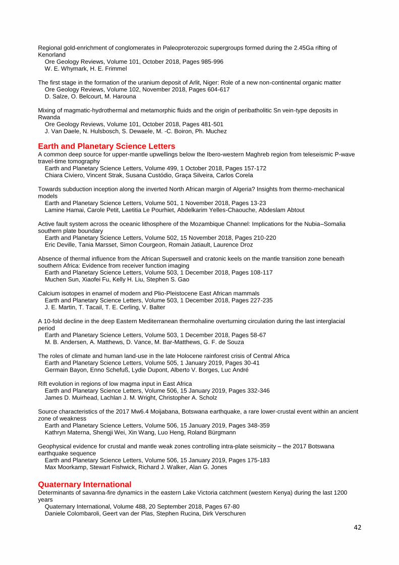
42
Regional gold-enrichment of conglomerates in Paleoproterozoic supergroups formed during the 2.45Ga rifting of Kenorland Ore Geology Reviews, Volume 101, October 2018, Pages 985-996 W. E. Whymark, H. E. Frimmel
The first stage in the formation of the uranium deposit of Arlit, Niger: Role of a new non-continental organic matter Ore Geology Reviews, Volume 102, November 2018, Pages 604-617 D. Salze, O. Belcourt, M. Harouna
Mixing of magmatic-hydrothermal and metamorphic fluids and the origin of peribatholitic Sn vein-type deposits in Rwanda Ore Geology Reviews, Volume 101, October 2018, Pages 481-501 J. Van Daele, N. Hulsbosch, S. Dewaele, M. -C. Boiron, Ph. Muchez
Earth and Planetary Science LettersA common deep source for upper-mantle upwellings below the Ibero-western Maghreb region from teleseismic P-wave travel-time tomography Earth and Planetary Science Letters, Volume 499, 1 October 2018, Pages 157-172 Chiara Civiero, Vincent Strak, Susana Custódio, Graça Silveira, Carlos Corela
Towards subduction inception along the inverted North African margin of Algeria? Insights from thermo-mechanical models Earth and Planetary Science Letters, Volume 501, 1 November 2018, Pages 13-23 Lamine Hamai, Carole Petit, Laetitia Le Pourhiet, Abdelkarim Yelles-Chaouche, Abdeslam Abtout
Active fault system across the oceanic lithosphere of the Mozambique Channel: Implications for the Nubia–Somalia southern plate boundary Earth and Planetary Science Letters, Volume 502, 15 November 2018, Pages 210-220 Eric Deville, Tania Marsset, Simon Courgeon, Romain Jatiault, Laurence Droz
Absence of thermal influence from the African Superswell and cratonic keels on the mantle transition zone beneath southern Africa: Evidence from receiver function imaging Earth and Planetary Science Letters, Volume 503, 1 December 2018, Pages 108-117 Muchen Sun, Xiaofei Fu, Kelly H. Liu, Stephen S. Gao
Calcium isotopes in enamel of modern and Plio-Pleistocene East African mammals Earth and Planetary Science Letters, Volume 503, 1 December 2018, Pages 227-235 J. E. Martin, T. Tacail, T. E. Cerling, V. Balter
A 10-fold decline in the deep Eastern Mediterranean thermohaline overturning circulation during the last interglacial period Earth and Planetary Science Letters, Volume 503, 1 December 2018, Pages 58-67 M. B. Andersen, A. Matthews, D. Vance, M. Bar-Matthews, G. F. de Souza
The roles of climate and human land-use in the late Holocene rainforest crisis of Central Africa Earth and Planetary Science Letters, Volume 505, 1 January 2019, Pages 30-41 Germain Bayon, Enno Schefuß, Lydie Dupont, Alberto V. Borges, Luc André
Rift evolution in regions of low magma input in East Africa Earth and Planetary Science Letters, Volume 506, 15 January 2019, Pages 332-346 James D. Muirhead, Lachlan J. M. Wright, Christopher A. Scholz
Source characteristics of the 2017 Mw6.4 Moijabana, Botswana earthquake, a rare lower-crustal event within an ancient zone of weakness Earth and Planetary Science Letters, Volume 506, 15 January 2019, Pages 348-359 Kathryn Materna, Shengji Wei, Xin Wang, Luo Heng, Roland Bürgmann
Geophysical evidence for crustal and mantle weak zones controlling intra-plate seismicity – the 2017 Botswana earthquake sequence Earth and Planetary Science Letters, Volume 506, 15 January 2019, Pages 175-183 Max Moorkamp, Stewart Fishwick, Richard J. Walker, Alan G. Jones
Quaternary InternationalDeterminants of savanna-fire dynamics in the eastern Lake Victoria catchment (western Kenya) during the last 1200 years Quaternary International, Volume 488, 20 September 2018, Pages 67-80 Daniele Colombaroli, Geert van der Plas, Stephen Rucina, Dirk Verschuren

43
Subsistence mosaics, forager-farmer interactions, and the transition to food production in eastern Africa Quaternary International, Volume 489, 30 September 2018, Pages 101-120 Alison Crowther, Mary E. Prendergast, Dorian Q. Fuller, Nicole Boivin
The last hunter-gatherers of China and Africa: A life amongst pastoralists and farmers Quaternary International, Volume 489, 30 September 2018, Pages 121-129 Benjamin Smith
Provenance, paleo-weathering and -redox signatures of estuarine sediments from Ghana, Gulf of Guinea Quaternary International, Volume 493, 10 November 2018, Pages 176-186 Edem Mahu, Daniel K. Asiedu, Elvis Nyarko, Samuel Hulme, Chris Y. Anani
E.M. van Zinderen Bakker (1907–2002) and the study of African Quaternary palaeoenvironments Quaternary International, Volume 495, 30 November 2018, Pages 153-168 Frank H. Neumann, Louis Scott
The first bone tools from Kromdraai and stone tools from Drimolen, and the place of bone tools in the South African Earlier Stone Age Quaternary International, Volume 495, 30 November 2018, Pages 87-101 Rhiannon C. Stammers, Matthew V. Caruana, Andy I. R. Herries
The emergence, spread, and termination of the Early Later Stone Age event in South Africa and southern Namibia Quaternary International, Volume 495, 30 November 2018, Pages 116-135 C. Britt Bousman, James S. Brink
Pollen-interpreted palaeoenvironments associated with the Middle and Late Pleistocene peopling of Southern Africa Quaternary International, Volume 495, 30 November 2018, Pages 169-184 Louis Scott, Frank H. Neumann
Holocene large mammal mass death assemblage from South Africa Quaternary International, Volume 495, 30 November 2018, Pages 49-63 Lucinda Backwell, Christine Steininger, Johann Neveling, Fernando Abdala, James Brink
Exploitation of sheep (Ovis aries) and goats (Capra hircus) by Iron Age farmers in southern Africa Quaternary International, Volume 495, 30 November 2018, Pages 79-86
Shaw Badenhorst
Inter-tooth comparison of δ13C and δ18O in ungulate tooth enamel from south-western Africa Quaternary International, Volume 495, 30 November 2018, Pages 144-152 Julie Luyt, Judith Sealy
Taphonomy of burnt bones from Wonderwerk Cave (South Africa) Quaternary International, Volume 495, 30 November 2018, Pages 19-29 Yolanda Fernández-Jalvo, Laura Tormo, Peter Andrews, M. Dolores Marin-Monfort
Taphonomic interpretations of the Haasgat HGD assemblage: A case study in the impact of sampling and preparation methods on reconstructing South African karstic assemblage formation Quaternary International, Volume 495, 30 November 2018, Pages 4-18 Justin W. Adams, Douglass S. Rovinsky
EVENTS
In Africa and about Africa (More information about the following events is on:
http://gsafr.org/events/)
Nigerian Mining and geosciences society (NMGS) – 55th international conferences & Exhibition (17-22 March,
2019)
The 5th International Symposium on Innovation & Technology in the Phosphate Industry will be held in 2019 at
Mohammed VI Polytechnic University – Congress Center, Benguerir, Morocco. More details will be available in
December 2018

44
In the frame of the igcp638 “Paleoproterozoic Birimian Geology for Sustainable Development”, of a special
volume dedicated to mineralizations: Geological Society of London (Lyell Collection) special volume :
“Mineralizations within Cratons, Metacratons and Basins”. The detailed “Call for Papers” will be sent after the
first item below is reached.
o Upload first a title (even provisional) of the article, the authors and the e-mail of the corresponding
author [deadline of paper proposition: Nov. 22nd, 2018]: submit
o Beginning of final submissions of papers through the portal of the Geological Society of London: Dec.
22nd, 2018 (hopefully)
The 3rd edition of the KENYA MINING FORUM Conference & Exhibition, 12-13 November in Nairobi, at the
Safari Park Hotel.
Technology Day & African Exploration Showcase – 15-16 November, Glenhove Conferencing Centre,
Johannesburg.
5th International Conference on Scientific Research ISR-2019 (RENEWABLE ENERGY & WATER
SUSTAINABILITY) – Sharm El Sheikh-Egypt, March 26-29 (Tu.- Fr.), 2019.
Colloquium Magmatisme, Métamorphisme et Minéralisations Associées (3MA-11), April 23-24, 2019 El Jadida,
Morocco. Abstracts submission: 15 January 2019.
Special Issue “The East African Rift: Tectonics, Magmatism and Natural Hazards”. International Geosciences
and Geoparks Programme Project Proposal Call.
The 5th edition of Mauritanides 2018 – 11-13 December 2018 – Nouakchott, Mauritania
The 5th ISR conference on Renewable Energy & Water Sustainability 26-29 March 2019 in Sharm El-Sheikh,
Egypt. More information: http://isr.tanta.edu.eg
Rest of the World (More information about the following events is on:
http://gsafr.org/events/)
Water Future International Conference – “Towards a Sustainable Future” to be held 23-27th September 2019 in
Bangalore, India.
12th International Conference on Earthquake Resistant Engineering Structures – 5-7 June 2019, Seville, Spain.
11th Inter Guiana Geological Conference: Tectonics & Resource Potential of NE South America. 19 – 20th
February 2019, Paramaribo, Suriname. More information
Energy and Sustainability 2019 – 8th International conference on Energy and Sustainability, 3-5 July 2019,
Coimbra, Portugal.
The International Earth Science Olympiad, Daegu, South Korea August 26 to September 03, 2019.
International Conference on Geoscience for Society (GeoSoc), Bangladesh Shilpakala Academy,
Segunbagicha, Dhaka, Bangladesh – March 14-17, 2019.
ECOSUD 2019 – 12th International Conference on Ecosystems and Sustainable Development, 19 – 21 June
2019 – Valencia, Spain.
River Basin Management 2019 (10th International Conference on River Basin Management Including all
Aspects of Hydrology, Ecology, Environmental Management, Flood Plains and Wetlands – 8 – 10 May 2019,
Alicante, Spain.
EGU (European Geosciences Union) General Assembly 2019 will bring together geoscientists from all over the
world to one meeting covering all disciplines of the Earth, planetary and space sciences. Call-for-sessions: until
6 September 2018. Abstract submission: October 2018–10 January 2019. Support application: October–1
December 2018.

45
OPPORTUNITIES
Two years Post Doc Opportunity: Geophysics – Soil
physics – Agrogeophysics
Liege,
Belgium 28/02/19
Geophysical Research or Staff Scientist (Energy
Geosciences) - 85937
Berkeley, CA,,
USA 07/01/19
2018 Postdoctoral Fellowship Program Moss Landing, CA,
USA 20/03/19
Research Scientist in the field of neotectonics Potsdam,
Germany 13/01/19
Postdoctoral research scientist - Data Scientist Changes
in dust fluxes and paleoproductivity across the past
glacial/interglacial cycles in the Southern Ocean
Bremerhaven,
Germany 01/02/19
Scientist in economic geology Trondheim,
Norway 21/12/18
Postdoctoral Research Fellow in Hydrology/Hydrogeology Aberdeen,
UK 20/01/19
Master of Petroleum Geoscience Perth, WA,
Australia 03/01/19
Postdocs in signal processing and machine learning of
geophysical data - 1012275
Aarhus C,
Denmark 21/12/18
Research Scientist Position - Marine Biogeochemistry Kiel,
Germany 31/12/18
UCD Post-doctoral Research Fellow Level 1 or 2: Discrete
element numerical modelling of the evolution of fault
systems
Dublin,
Ireland 08/01/19
RawMatCop Manager Berlin,
Germany 31/12/18
UCD Post-doctoral Research Fellow Level 1 or 2: The
kinematics of fault systems in offshore Ireland -
implications for fault related trapping and leakage
Dublin,
Ireland 08/01/19
International Master of Research course in Solid Earth
Sciences
Paris,
France 28/02/19
Earth Observation Data Scientist London,
UK 28/12/18
Cambridge C-CLEAR NERC DTP PhD Studentships Cambridge,
UK 03/01/19
Ph.D. position in Statistical Seismology: Enabling
dynamic earthquake risk assessment
Zurich,
Switzerland 06/01/19

46
Research Associate - Measurements of zeta potential in
carbonate rocks
London,
UK 18/01/19
BPI Senior Research Fellowship: 2019-2024 Cambridge,
UK 31/12/18
Postdoctoral Investigator (m/f) in the area of Marine
Biogeochemistry
Geesthacht,
Germany 06/01/19
Postdoctoral Research Associate / Postdoctoral Research
Fellow: Mineralogy and geochemistry of environmentally
friendly marine concrete materials
Exeter,
UK 08/01/19
Postdoctoral position in atomistic modelling Potsdam,
Germany 06/01/19
Manager Geosciece Mapping Through Cover - MIS18090 Perth,
Australia 23/11/18
Geoscientist or Mining Engineer (M.Sc) Hannover,
Germany 11/12/18
Post-doctoral Research Fellows Sydney,
Australia 01/01/19
High-Pressure Experimental Geoscientist Sydney,
Australia 17/12/18
Post-Doctoral Researcher - Atmospheric Inverse
Modelling
Wellington,
New Zealand 18/12/18
3 MSc positions - Geomicrobiology and Mine Waste Saskatoon, SK,
Canada 22/12/18
Research Assistant - development of sedimentological
databases
Leeds,
UK 21/12/18
Visiting Faculty Exchange Fellowships, Cooperative
Institute for Modeling the Earth System
Princeton, NJ,
USA 15/01/19
Wiss. Mitarbeiter / Wiss. Mitarbeiterin (Preadoc),
Sedimentäre Systeme: Earthshape - Earth Surface
Shaping by Biota (Earthshape.net)
Berlin,
Germany 10/12/18
2 PhD Student Positions - Coral Climatology Bremen,
Germany 31/01/19
Associate or Senior Editor (Biogeosciences) London, Shanghai,
New York, or Berlin,
UK
05/12/18
PhD position in geochemistry & stable isotope research Erlangen-Nürnberg,
Germany 27/11/18
Full-time PhD Studentships Milton Keynes,
UK 21/01/19

47
Post-Doctoral Position Utilizing U-PB LA-ICP MS
Geochronology
Stockholm,
Sweden 15/12/18
Researcher position in the Geomatics Division - Remote
Sensing Department
Barcelona,
Spain 14/01/19
Post Doctoral Fellow Mineral Exploration Mapping Sudbury, ON,
Canada 15/12/18
4 MSc students and 1 PhD student to conduct mapping-
based research
Sudbury, ON,
Canada 26/01/19
PDF/Research Associate Positions, geological mapping-
based research
Sudbury, ON,
Canada 31/12/18
PDF/Research Associate in Applied Exploration
Geophysics
Sudbury, ON,
Canada 15/12/18
Research Fellow (f/m): in the field of ore deposits Karlsruhe,
Germany 15/12/18
MSc in Petroleum Geoscience London,
UK Apply Now
MSc in Applied Computational Science and Engineering London,
UK Apply Now
PhD student: Ocean carbon cycling, novel insights from
planktonic foraminifera
Edinburgh,
UK 31/01/19
Steve Fossett Postdoctoral Fellowship in Earth and
Planetary Science
St. Louis, MO,
USA 15/01/19
Petroleum Geoscience [MSc]
Pollution and Environmental Control [MSc]
Manchester,
UK Apply Now
Research Associate - Modelling Multi-Phase Flow in
Magma Reservoirs
London,
UK 01/01/19
PhD Opportunity - Controls on tidewater glacier retreat in
Alaska
Wollongong,
Australia 30/11/18
Four funded Ph.D. Student Opportunities - Earth and
Energy Sciences
Lafayette, LA,
USA 10/01/19
Graduate Research Position in Li Reactive Water Group in
Civil and Environmental Engineering
University Park, PA,
USA 09/01/19
Post-doctoral position in Experimental Mineral-Fluid
Physics and Chemistry
Cambridge,
UK 07/12/18
Experienced Geophysicist Nottingham,
UK 26/11/18
M.Sc in Uranium Exploration Brandon,
Canada 28/02/19

48
CONTACT THE COUNCIL
The Geological Society of Africa’s council is appreciated your opinion and inputs. All of your suggestions and comments
will be taken into considerations. Just drop us an email:
President: Prof. Gbenga Okunlola (Nigeria); Department of Geology, University of Ibadan.
Secretary General: Dr. Maideyi Lydia Meck (Zimbabwe); Geology Department, University of Zimbabwe.
Honorary Treasurer: Prof. Asfawossen Asrat (Ethiopia); Department of Earth Sciences, Addis Ababa University.
Assistant Secretary General/Membership Secretary: Prof. Prosper M. Nude (Ghana); Department of Earth Science,
University of Ghana. ([email protected])
Vice President for Southern Africa: Prof. Dr. Dr. Wlady Altermann (South Africa); Department of Geology, University
of Pretoria. ([email protected])
Vice President for Northern Africa: Prof. Youssef Driouch (Morocco); Geology department, Mohamed Ben Abdallah
University (USMBA). ([email protected] / [email protected])
Vice President for Western Africa: Dr. Yao Agbossoumonde (Togo); Department of Geology, University of Lome.
Vice President for Eastern Africa: Prof. Beneah Daniel Odhiambo (Kenya); Moi University. (
Vice President for Central Africa: Mr. Léon Bora Uzima Bahavu (Democratic Republic of the Congo); Centre
d’Expertise et d’Etudes Géologiques. ([email protected])
Councillor for Northern Africa: Dr. Kholoud M. AbdekMaksoud (Egypt); Institute of African Research and Studies,
Cairo University. ([email protected])
Councillor for Southern Africa: Ms. Anna- Karren Nguno (Namibia); Geological Survey of Namibia.
Councillor for Western Africa: Dr.Adama Sangare (Mali); IAMGOLD Exploration Mali S.A.R.L
Councillor for Eastern Africa: Mr. Jean-Claude Ngaruye (Rwanda); Energy, Water and Sanitation Authority.
Councillor for Central Africa: Pending
GSAf’s Newsletter Editor/Information Officer: Dr. Tamer Abu-Alam (Norway/Egypt); the University of Tromsø -
The Arctic University of Norway. ([email protected])

© Geological Society of Africa
Geological Society of AfricaNewsletter
Volume 8 - Issue 8 (December, 2018)
Edited byTamer Abu-AlamEditor of the GSAf Newsletter
Cover ImageDigital Elevation Model of Africahttps://www.baroud.fr/cartes-topo-garmin-afrique/24-carte-topo-map-southern-africa.html