Embed Size (px)
Citation preview


GEOLOGICAL SURVEY OF CANADA DEPARTMENT OF ENERGY, MINES A N D RESOURCES
GRANULAR RESOURCE INVENTORY - SOUTHERN MACKENZIE VALLEY
KAKISA RIVER (85D) 1.:125,000
Gretchen V . Minning d. A. Rennie J, L. Domansky A. N, Sartorelli

Table of Contents
Summary Introduction General Geology and Physiography Geologic Description of Exploitable Map Units
Unconsolidated Deposits Glacial Deposits
Glaciofluvial Deposits Glaciolacustrine Deposits Morainal Deposits
Alluvial Deposits
High Quality Bedrock for Construction Materials Bedrock
Geographic Distribution of Exploitable Materials Kakisa River Area North Central Moraine Area Cameron Hills Glaciofluvial Deposits Miscellaneous Deposits
Tabular Summary Appendices
Figures Appendix A - Sources of Information
Figure 1 - Physiographic Regions - Kakisa River (85D) Figure 2 - Natural Granular Materials, Kakisa ,
River (85D) District of Mackenzie, North- west Territories
Geomorphology Maps, Open File 93.
District o€ Mackenzie
Figure 2b - Legend for Surficial Geology and
Figure 3 - Bedrock Geology, Kakisa River (85D),
1 1 3 4 5
15 1 5 6 6 7 8 8 9 9 9 10 10 11 15 15

- 1 -
SUMMARY
Coarse natural granular material and competent, crushable bedrock
are abundant at certain localities in the Kakisa River map-area. Uncon-
solidated deposits of glaciofluvial, alluvial, and glaciolacustrine origin
contain sand and gravel. Morainal deposits also contain some coarse
material along with fine grained till.
Glaciofluvial outwash plain, hummocky, ridged, and esker deposits
and a glaciolacustrine beach complex are the best sources of sand and
gravel. These deposits are generally well drained, lack organic cover,
and are unfrozen,
Alluvial deposits of the Kakisa River and one of its tributaries contain
significant amounts of sand and gravel. At certain localities these deposits
are well drained and unfrozen.
Morainal deposits with coarse material usually are ridged. Shot hole
records show two moraine plain deposits that also contain high percentages
of sand and gravel.
Bedrock is at the surface only in the northeastern corner of the map-
area near Foetus Lake. At this locality competent bedrock of three form-
ations could be crushed to obtain granular material.

INTRODUCTION
Granular material for construction purposes can be, obtained from
unconsolidated deposits or competent bedrock. This report will discuss the .
distribution and physical characteristics of these sources of granular material
and will also present an estimate of the quantity 1 . of material available in
unconsolidated deposits.
Unconsolidated deposits resulting from various geologic processes,
I . e . glacier activity, river deposition, wind action, and mass wasting, are a
SOURCE of natural granular material of gravel (> 2 mm), sand (1/16-2 mm),
silt (1/16-1/256 mm), and clay (< 1/256 mm) sizes.
Good natural granular material for constructlon uses 1.4 generally
larger than silt size (1/16 mm) In the southern Nackenzie Valley g a d 1
' granular material comes primarily from deposits of glaciofluvial and
glaciolacustrine origin, and secondarily from morainal, eolian, alluvial,
. and collwtal deposits.
I3edrock that can be crushed by mechanical means can also supply
granular material. Competent bedrock suitable for crushing includes limestone,
dolomite, sandstone, and certain Igneous and metamorphic rock types. Other less
resistant rock types, i .e. shale, can be used for f i l l material but wil l not be In-
cluded here as a bedrock source of granular material. In fie southern Mackenzie
0 'Silt A d clay size m3terid < 1/16 mm can be used for fill. This material is unlimited in the unconsolidated deposits of this map-sheet' and will not be included in thc numerical estimate of the quantity of granular material available.

- 2 - 1
b
Valley limestone and dolomite are the best sources of rippable bedrock.
Published and unpublished Geological Survey of Canada maps and reports, ?
.* personal communication with officers of the Geological Survey, and field
investigation have provided the basic data for this report, Supplementary
information on distribution, thicknesses, and textures of unconsolidated
deposits was obtained from unpublished oil and pipeline company shot hole .
and drilling records (see sources of information, Appendix A). i
A Geological Survey surficial geology map at a scale of 1:125,000
(Rutter , N. W., and Boydell, A. N., in press) provided data on location
and areal extent of unconsolidated deposits containing good granular material.
This map will be indexed as GSC Open File and when published it may
be viewed at the Geol~gkal Survey of Canada &ices in Ottawa, Calgary and
Vancouver, Copies will be obtainable at a nominal cost from Riley's
Datashare International, 631 - 8 Avenue South West, Calgary, Alberta.
Quantities of natural granular material in unconsolidated deposits
have been computed using data on areal extent and thicknesses obtained from
the surficial geology map, drilling results, and field observations. Variables
such as ground ice and height of water table were considered when deriving
final volumes of material available in each deposit . The tabular summary
at the end of this report contains detailed volumetric data.
2
2 The area of each deposit was measured on the surficial geology map with a planimeter, The average thickness of the deposit was multiplied by the area to get the total volume of the deposit. Variables , i.e. water table, type of deposit, were assessed to obtain the final percentage of the total volume that is listed in the tabla as material available for exploitation,

0
- 3 -
Information on bedrock that can supply granular material comes mainly
from Geological Survey of Canada Paper 58-11. Map 28-1958, which
accompanies this paper, has been used as a base for indicating competent
bedrock that is available at or near the surface,
GENERAL GEOLOGY AND PHYSIOGRAPHY
The northern half of the Kakisa River map-area falls within the Great
Slave Plain physiographic region and the southern half is part of the Alberta
Plateau (see location map, Figure 1).
Bedrock geology was mapped by the Geological Survey on Operation
Mackenzie in 1957 (Douglas, 1959). A reconnaissance surficial geology
investigation was undertaken by E. G. Craig as part of this operation
(Douglas, 1959; Craig, 1965). A detailed surficial geology map based on
airphoto interpretation and field investigations is being compiled by the
Geological Survey (Rutter, N. W. , and Boydell, A. N. , in press) . Bedrock formations are mostly Cretaceous shales and Upper Devonian 3
limestones with minor sandstones.
The Cretaceous shales underlie most of the area and are poor sources
of granular material.
The Upper Devonian limestones near Foetus and Two Islands Lakes
are competent formations suitable for crushing,
3 A formation is a bed (of rocks) or assemblage of beds with well-marked upper and lower boundaries that can be traced over a considerable tract of country (Holmes, 1965).
1 2 6 O 124O * 122O
PHYSIOGRAPHlC REGIONS - KAKISA RIVER, 85D
'd miles Scab
Figure I after Bostock 1969
- 4 -
i
Morainal deposits cover bedrock throughout the area. shot hole
4 records show them to be at least 50 feet thick in most places . Where this
ground moraine covers the nearly flat lying Cretaceous shales there is *
‘ I
often poor drainage and thick organic deposits. In addition to the ground
moraine cover, glacier activity has produced minor glaciofluvial outwash
deposits and glaciolacustrine beach deposits. Rivers and creeks have
reworked unconsolidated material into alluvial plain and terrace deposits.
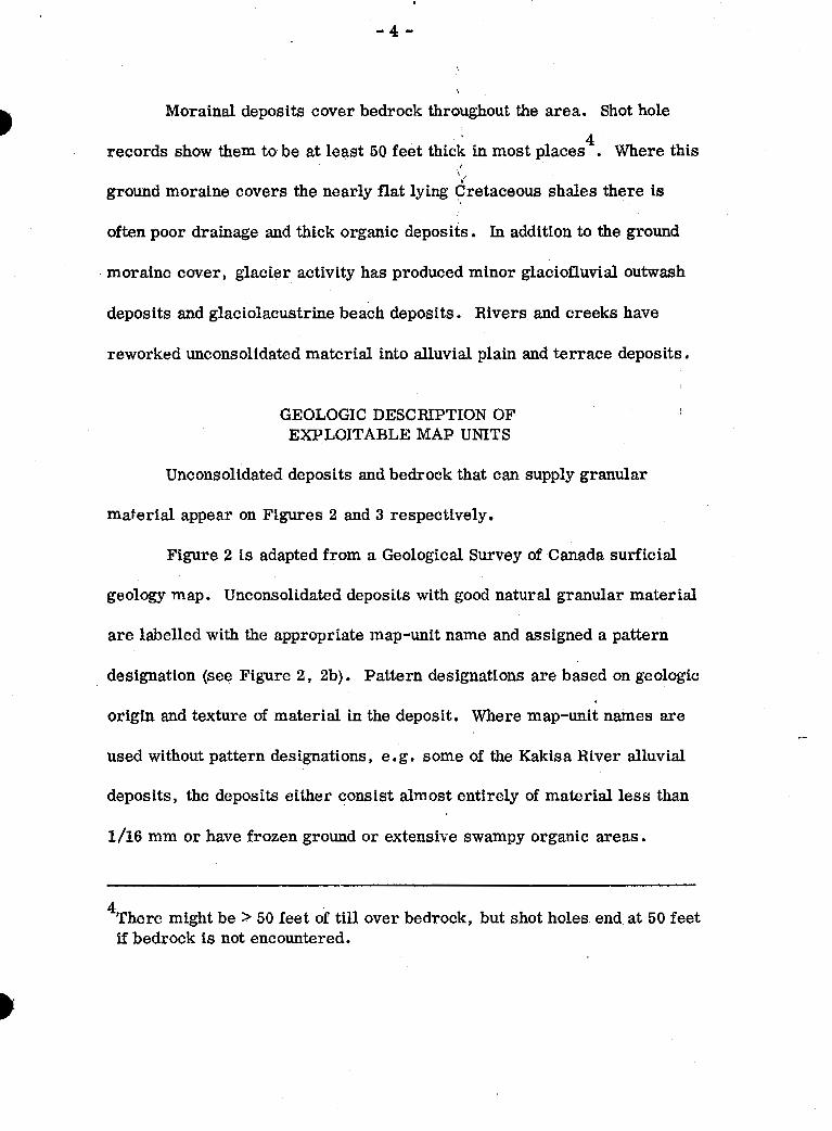
GEOLOGIC DESCRIPTION OF EXPLOITABLE MAP UNITS
Unconsolidated deposits and bedrock that can supply granular
material appear on Figures 2 and 3 respectively.
Figure 2 is adapted from a Geological Survey of Canada surficial
geology map. Unconsolidated deposits with good natural granular material
are labelled with the appropriate map-unit name and assigned a pattern
designation (see Figure 2 , 2b). Pattern designations are based on geologic
origin and texture of material in the deposit. Where map-unit names are
used without pattern designations, e.g. some of the Kakisa River alluvial
deposits, the deposits either consist almost entirely of material less than
1/16 mm or have frozen ground or extensive swampy organic areas.
4 There might be > 50 feet of till over bedrock, but shot holes end at 50 feet if bedrock is not encountered.

- 5 -
Figure 3 is a Geological Survey of Canada bedrock geology map,
Bedrock at or near the surface is indicated by heavy dashed lines or an x.
Bedrock formations preceded by an asterisk (*) could be crushed to obtain
granular material (see legend, Figure 3) .
Unconsolidated Deposits
Glacial Deposits
Glacidluvial deposits contain high quality granular material of gravel
and sand size. Glaciolacustrine beach deposits consist mainly of coarse
sand and gravel, Morainal deposits are generally fine material, although
several moraine plain and ridged deposits contain sand and gravel,
Glac iofluvial %pos.its (Gp, Gpc, Gt, Gh, Gr , Ghr, Gphr, G r + tMp, G r , esker)
sh
Glaciofluvial deposits scattered throughout the area consist of sand
and gravel. They have been indicated by several dot and circle patterns or
an esker symbol on the natural gmnular materials map (see Figure 2).
The capital G in the unit mapped indicates the glaciofluvial origin of
the deposit and the lower case prefix denotes the principal types of material,
e,g, silt (si), sand (s), and gravel and sand (g). It should be noted that if
two prefixes are used, the first refers to the most abundant constituent
(see legend for surficid geology maps , Figure 2b).

- 6 -
Topographic expression of the unit is indicated by the suffix attached,
e.g. terrace (t), ridge (r), hummocky (h), plain @) Symbols like esker ( 8 )
also show surface form. Glaciofluvial units vary from flat and gently
sloping (Gp, Gt) to ?mrnmocky and ridged (Gh, Gr, Ghr, eskers) Thick-
nesses of glaciofluvial deposits vary from 5 to 50 feet. Eskers are fairly
small and a height of 20 feet and width of 30 feet was used in calculating
volumes.
LY
1 .
Glaciofluvial deposits are generally well drained and have little ground
ice or organic cover. Deposits affected by these factors are described in
the tabular summary.
I Glaciolacustrine Deposits (LPbX,
i~ Only one glaciolacustrine be,ach deposit is present. The capital L in
the unit name indicates its glactolacustrine origin and the lower case prefixes
and suffixes give textural and morphologic information respectively.
The beach deposit (Lpbx) consists of ridges of sand and gravel which
rise above the surrounding plain. An average thickness of 27 feet was used
in calculatiw the volume of rnater€d. This deposit is well drained, has
little organic cover, and is probably unfrozen.
Morainal deposits have been mapped as M with appropriate textural
.-
and morphologic modifiers. Well drained deposits with 3 - 5% coarse

- 7 -
$
material have been assigned a broken line pattern or end moraine symbol ( #)
5 on the natural granular materials map . Also some morainal deposits (Mpr)
without pattern designation consist of well drained, fine grained till with , b
occasional ridges of gravel. These deposits could provide good fill material
for construction projects even though they are not coarse enough to classify
as a granular resource. When thicknesses were unknown a. figure of 60 feet
was used in volume calculations for material in morainal deposits. I
Alluvial Deposits (AP, At)
Alluvial deposits consist of silt, sand, and gravel-sized material.
Only those with significant coarse material have been assigned a cross-
hatched pattern on the accompanying natural granular materials map (see
Figure 2). All alluvial deposits are mapped as A with textural and morphologic
modifiers.
Alluvial deposits form plains (Ap) with little relief along present
river and stream channels and terraces (At) above present channels.
Alluvial plain and terrace deposits have varying dimensions. When thickness
data was unavailable, an average figure of S feet was used for calculating
volumes of alluvial plain deposits and 40 feet was used for terrace deposits.
..
Two gravelly moraine plain units D-72, D-73 were detected by shot hole records. Only more drilling will outline their exact dimensions.

- 8 -
Alluvial terrace deposits with a pattern designation on the granular
materials map generally contain coarse material and are fairly well drained
with only minor ground ice and organic cover. Alluvial plain deposits have
more fine material and often contain permafrost, e . g, Ap deposits along
Kakisa River.
Bedrock
Upper Devonian limestone of three geologic formations can be used
to supply granular material. Outcrop areas of these formations are indicated
on Figure 3 with heavy dashed lines or an x symbol.
All but the northeastern portion of the map-sheet is underlain by soft
Cretaceous shales which are poor .sources of construction material. In the
northeast near Rabbit, Foetus, and Two Islands Lakes the three competent
Devonian limestone units are at or near the surface ,
High Quality Bedrock for Construction Materials
Bedrock formations are described in order of their suitability for
construction materials.
Unit 21 is an Upper Devonian sandy, silty limestone, It is a tough,
well jointed formation and is a good source of crushable rock,
Unit 22, an Upper Devonian sandy limestone, varies in quality with
locality and stratigraphic horizon. In the vicinity of Rabbit and Foetus Lakes,
the limestone is fine to coarse grained, fossiliferous, and a good source of
construction materials.

- 9 -
Unit 20, an Upper Devonian sandy limestone, is a competent form-
ation except for exposures with siltstone and mudstone members,
GEOGRAPHIC DISTRIBUTION OF EXPLOITABLE MATERIALS
All natural granular deposits have been assigned an identification
number, e.g. D-1, for use in assembling data (Figure 2). Bedrock form-
ations are shown on Figure 3 .
' .
Further details on volume estimates of natural granular material
and bedrock resources are found in the tabular summary.
I
I
I' Kakisa River Area
Alluvial and glaciofluvid terrace deposits along Kakisa River and
its tributaries contain considerable-coarse granular material. Shot hole
information indicates at least 40 feet of material in alluvial terraces. It
is estimated that these deposits contain 20% usable granular material.
Field observations and shot hole records show 50 feet.of sediment
in glaciofluvial terraces along the western portion of the river. Forty
per cent of the material in these deposits would probably be sand and gravel.
- North Central Moraine Area
Moraine plain and ridge deposits in the north central part of the map-
sheet contain sand and gravel, Shot holes show coarse material to be 50 feet
thick at some localities. Volume calculations were based on the assumption
that only 5% of the material in these deposits is coarse with the remainder
being fine grained till.

- 10 - i
Cameron Hills Glaciofluvi'al Deposits
Scattered hummocky and ridged glaci$luvid deposits approximately a
50 feet thick and 70% usable are found in the southeastern corner of the
map-area near the Cameron Hil ls .
Miscellaneous Deposits
Glaciofluvial plain, ridge, and esker deposits are found at various
locations not previously mentioned. Most of the plain and ridge deposits
are 50 feet thick and 40 - 70% usable for granular materials. Eskers are
20 feet high, 30 feet wide, and 80% sand and gravel.
A glaciolacustrine beach deposit (27 feet thick and 70% usable
material) and competent bedrock for crushing purposes are located in the
northeastern corner of the map-area.

D- 1 D-13 D-14 D-22 D-2 5 D-3 0 D-32
D- 3
D-19
D-11
D- 4
D- 2 D-26 D-27
Description & Material
Glaciofluvial outwash plain, gravel and sand
Glac iofluvial outwash plain, channelled,gravel and sand
Glaciduvial outwash plain, gravel and sand, some ridges
TABULAR SUMMARY
Glaciofluvial outwash plain, gravel and sand, 5 - 15% organic material, possible ground ice
Glaciofluvidl plain deposit, some hommocky and ridged areas, gravel and sand, 5 - 15% organic material, possible ground ice
Glaciofluvial terrace deposits, gravel and sand
Thickness fft.)
50 50 50 50 50 50 50
50
50
50
50
50 50 50
Area (8q. mi.)
1.63 1.82 2.68 0.89 0.35 2.87 2.37
1,20
9.49
4.74
3.96
6.69 0.19 0.19
Volumes Total
85.86 95.71 141.10 46.75 18.36 151.13 124.78
63.07
499.63
249.56
208.42
352.24 9.86 9.86
(Million yd. ) 3
Available
34.27 38.28 56.44 18.70 7.34
60.45 49.91
25.22
199.85
87.34
72.94
140.89 3.94 3.94
I w CI I
i

D- 6 Glaciofluvial ridges of gravel and sand D- 7 D-12 D-3 1 D-60 D-71
50 50 50 50 50 50
D- 5 Glaciofiuvial deposits, hummocky, ridged, 50 D-24 gravel and sand 50
D-23 Veneer of glaciofluvid gravel wer'shale . 5
D- 15 Areas of glaciofluvial gravel ridges and 50 D-17 till plain deposits . 50 D-18 50
D-20 Glaciofluvial ridges of gravel and sand, some till plain
D- 8 Glaciofluvial deposits, hummocky, D-2 1 gravel and sand D-2 8
D- 9 Glacidcvial gravel and sand deposits, D-10 hummocky, 5 - 15% organic material, D-2 9 possible ground ice D-33 D-34
50
50 56 50
Area (sq. mi.)
0.70 0.50 1.05 1.40 0.89 0.97
9.01 0.97
1.28
3.30 4.39 1.24
2.99 -
2.10 1.16 0.19
2.99 5.09 0.46 0.70 0.89
Volumes Total
36.12 26,18 55 25 15.61 46.75 51.00
153 .17 51.00
7.92
173 74 231.05 65.28
157.42
110.50 61.03 9.86
157.42 267.92 24.14 36.72 46.75
(Million yd. ) Available
3
25.70 18.32 38.67 51.52 32.72 20.40
107.23. 35.70
3.16
69.49 92.41 42 43
102 . 32
77-35 42.12 6.88
102.32 174.14 15 69 23 . 86 30.38

D-16
D-57 D-58 D-59 D-61 D-62 D-63 D-64 D-65 D-6 6 D-67 D-68
D-3 5
D-3 6 D-37
D-40
D-3 8
D-3 9
D-4 1
Descr€ption & Material
Glaciofluvial gravel deposit, channelled
Esker ridges, sand and gravel
Alluvial plain deposit, sand and silt
Alluvial plain deposits, sand and gravel
Alluvial plain deposit, very thfck, silt, sand and gravel
Alluvial terrace deposit, sand and gravel
Alluvial terrace deposit, silt and gravel
Glaciolacustrine gravel, smdpd silt beach deposit
Thickness et.)
50
20 20 20 20 20 20 20 20 20 20 20
a
8 8
40
40
40
27
Area Volumes (sq. mi.) Total
1.24 65.28
0.092 0-18 0.092 0.43 0.30 0.09 0.20 0.23 0.17 0.30 0.12
1.28 lI.88-.
0.19 1.74 0.73 6.78
1 .?5 70.46
0.58 23.27
(Million yd. 1 Available
26.11
3
0.07 0.15 0.07 0.34 0.24 0.07 0.16 0.18 0.13 1
0.24 0.09 1
c1 0
. . 2*3-7 - ..- . / -
0.34 1.35
25.34
14.09
4.65
207.01

Description & Material
D-69 Moraine ridge, gravelly or sandy till
-72 Morainal plain, till with gravel and D-73 sand lenses
20
60 5.52 60 32.41
D-70 Morainal plain of till, gravel ridges, 60 2-10 5 - 15% organic material, possible ground ice
D-5 1 Morainal ridges of till, gravel, and sand, 3.15 D-52 5 - 15% organic material, possible ground ice 3.73
D-54 1.71
D-56 0.66
13-53 0.85
D-55 1.40
Bedrock - limestone of Unit 21 @good) limestone of Unit 22 good) limestone of Unit 20 @;ood-fair)
Volumes Total
0.86
341.80 2,038.00
130.00
29.25 34.65
7.89 15.87 12.99 6.12
3 (Million yd. 1
Available
0.04
17.09 101.92
3*90
5,85 6.93 1.57 3 -27 2.59 1.22.
Total available volume of natural granular materials - 2340.28 million cubic yards

- 15 - \
Appendix A *
r i
Sources of Information
American Geological Institute 1960: Glossary of geology and related sciences; Am. Geol. Institute.
1969: Physiographic regions of Canada; Geol. Surv. Can,, Map l254A.
Chevron Standard Oil Co. Seismic Shot Hole Data (unpublished).
Craig, E. G. 1965: Glacial Lake McConnell, and surficial geology of parts of Slave
River and Redstone River map-areas, District of Mackenzie; Geol. Surv. Can. , Bulletin 122.
Douglas, R. J. W. 1959: Great Slave and Trout River map-areas, Northwest Territories;
Geol. Surv. Can., Paper 58-11.
Holmes, A . H . 1965: Principles of physical geology, Thomas Nelson and Sans LTd,
London ,
Prest, V. K., Grant, D. R . , and Rampton, V. N., 1967: Glacial map of Canada; Geol Surv. Can. , Map 1253A.
Ripley, Klohn, and Leonoff Alberta Ltd., 1969: Mackenzie Valley pipeline report, volumes I and Il,
1970: Presentation of test hole log data.
Rutter, N. W., and Baydell, A. N., in press: Surficial geology and geomorphology of Kakisa River , 85D,
Geol. Sum. Can., Open File Series .