Embed Size (px)
Citation preview

Geological and Seismological Analysis of the 13 February 2001
Mw 6.6 El Salvador Earthquake: Evidence for Surface
Rupture and Implications for Seismic Hazard
by Carolina Canora, José J. Martínez-Díaz, Pilar Villamor, Kelvin Berryman,José A. Álvarez-Gómez, Carlos Pullinger, and Ramón Capote
Abstract The El Salvador earthquake of 13 February 2001 (Mw 6.6) causedtectonic rupture on the El Salvador fault zone (ESFZ). Right-lateral strike-slip surfacerupture of the east–west trending fault zone had a maximum surface displacement of0.60 m. No vertical component was observed. The earthquake resulted in widespreadlandslides in the epicentral area, where bedrock is composed of volcanic sediments,tephra, and weak ignimbrites. In the aftermath of the earthquake, widespread damageto houses and roads and the hazards posed by landslides captured the attentionof responding agencies and scientists, and the presence of surface-fault rupturewas overlooked. Additionally, the tectonic context in which the earthquake took placehad not been clear until mapping of the ESFZ was completed for the present study. Weidentified several fault segments, the distribution of surface ruptures, the aftershockpattern, and fault-rupture scaling considerations that indicate the 21-km-long SanVicente segment ruptured in the 2001 event. Static Coulomb stress transfer modelsfor the San Vicente rupture are consistent with both aftershock activity of the 2001sequence and ongoing background seismicity in the region. At Mw 6.6, the 2001earthquake was of only moderate magnitude, yet there was significant damage tothe country’s infrastructure, including buildings and roads, and numerous deathsand injuries. Thus, earthquake hazard and risk in the vicinity of the ESFZ, which strad-dles the city of San Salvador with a population of >2 million, is high because evenmoderate-magnitude events can result in major damage, deaths, and injuries in theregion.
Introduction
On 13 February 2001, an Mw 6.6 earthquake struck thecentral region of El Salvador (Central America) at a hypo-central depth of 10� 5 km. An earlier, large normal-faultingevent (Mw 7.7, hypocentral depth of 54 km) occurred withinthe subducting Cocos plate 40 km off the Salvadorian coastonly one month earlier (13 January 2001). Although the 13February event was smaller in magnitude than the Januaryearthquake, the February earthquake was shallower and nearmajor urban areas and, as a result, caused substantialdamage. The January Mw 7.7 subduction-related earthquakeresulted in more than 900 deaths and severe damage (mainlycaused by large earthquake-induced landslides). The Febru-ary Mw 6.6 earthquake caused more than 300 deaths andmore large landslides. Because the widespread damaginglandslides triggered by the February Mw 6.6 earthquake andimmediate focus on the emergency response, no geologicalinvestigations were undertaken to identify the tectonic struc-ture responsible for this event. Most of the scientific response
concentrated on the study of mass movements triggered byseismic shaking.
Destructive earthquakes similar to the 2001 events haveoccurred during the last century inEl Salvador (Bommer et al.,2002), as is expected at a plate boundary where the relativemotion between the plates is 70–85 mm=yr (DeMets, 2001)(Fig. 1). El Salvador deformation associated with trench-parallel strike-slip movement in the upper crust is estimatedto be at least 8 mm=yr (DeMets et al., 2008). It is possible thatearlier historic earthquakes had surface rupture, but, prior tothis study, the distribution of active faults in El Salvador hasonly been known in the most general way (Martínez-Díazet al., 2004; Corti et al., 2005).
In this paper, we present field evidence of surface ruptureassociated with the 13 February 2001, Mw 6.6 earthquake,define the seismic source, and infer the fault rupture areafrom seismic and geological data. We also present the firstdetailed active fault map of the area where the earthquake
2873
Bulletin of the Seismological Society of America, Vol. 100, No. 6, pp. 2873–2890, December 2010, doi: 10.1785/0120090377

Figure 1. Tectonic setting of northern Central America. (a) Tectonic plates, major crustal blocks, and faults. Arrows show relative direc-tions of displacements. PF, Polochic fault; MF, Motagua fault; SIT, Swan Island transform; SG, Sula graben; IG, Ipala graben; HD, Hondurasdepression; GF, Guayape fault; ND, Nicaraguan depression; HE, Hess escarpment. (b) Shuttle Radar Topography Mission (SRTM) image ofEl Salvador with historically destructive earthquakes (black circles) and instrumental epicenters (small dots) (Ms > 2:5, period 1977–2001)from the USGS–National Earthquake Information Center (NEIC) catalogue (see Data and Resources section). Small focal-mechanismsymbols are for events of Mw > 5:5 (1977–2001, Global CMT database; see Data and Resources section), and large focal-mechanismsymbols are for events of Mw > 6:5 (from Buforn et al., 2001). ESZF, El Salvador fault zone; black dashed line, El Salvador border.
2874 C. Canora, J. J. Martínez-Díaz, P. Villamor, K. Berryman, J. A. Álvarez-Gómez, C. Pullinger, and R. Capote

occurred. The study involved spatial and temporal analysis ofthe seismic sequence and its relation to surface-rupturefeatures; review of vertical aerial photograph and analysisof digital terrain models (DTM) to map active faults in theearthquake area; and field reconnaissance of the possiblesurface rupture and secondary effects associated with theearthquake along mapped fault traces. Spatial analysis oflandslides triggered by the earthquake also helped us to definethe probable length of surface-fault rupture.
We calculated Coulomb static stress changes for thegeologically defined fault rupture model associated withthe 13 February 2001 mainshock. We did this to evaluate thecoherence of our rupture model with the spatial and temporaldistribution of aftershocks. Coulomb static stress analysisalso helped us determine the stress loading produced by the2001 sequence on active faults in the area, which has impor-tant implications for the local seismic hazard.
Geological and Seismotectonic Setting
Central El Salvador is located in the northern part of theCentral America volcanic arc that extends from Guatemala toCosta Rica along the active Pacific margin (Fig. 1a). Thisvolcanic arc is associated with the subduction of the Cocosplate beneath the Caribbean plate. The arc ends abruptly tothe north against the Polochic fault in Guatemala, in a diffusetriple junction between the Cocos, Caribbean, and NorthAmerican plates (Plafker, 1976; Guzmán-Speziale et al.,1989; Guzmán-Speziale and Meneses-Rocha, 2000; Lyon-Caen et al., 2006).
The Cocos plate converges with the Caribbean plate at70–85 mm=yr and has a small oblique component (DeMets,2001). The forearc sliver between the Mesoamerican troughand the Central American volcanic arc is moving northwestrelative to the Cocos plate, parallel to the trough. DeMets(2001) considered this displacement to be the result of strainpartitioning, which produces a strike-slip regime along thevolcanic arc and explains the strike-slip focal mechanismsof larger earthquakes in this area. However, recent GlobalPositioning System velocity data show that the degree ofcoupling in this part of Central America is very low (Cor-rea-Mora et al., 2009), suggesting that strain partitioningmay not be an effective driving mechanism and that thestrike-slip regime along the volcanic arc is actually drivenby the relative eastward drift of the Caribban plate (Álvarez-Gómez et al., 2008).
The Salvadorian sector of the subduction zone containstwo distinct zones that have contrasting earthquake focalmechanisms: thrusting along the Wadati–Benioff zone andnormal faulting within the subducting plate from extensionalforces generated by slab-pull forces or bending of the sub-ducting plate (Isacks and Baranzagi, 1977). The largestearthquakes (Mw >7:0) along the subducting plate tend torupture at intermediate depths and can cause moderatelyintense shaking across wide parts of southern El Salvador.The most recent example of such an event is the 13 January
2001 Mw 7.7 earthquake (Bommer et al., 2002) that pro-duced several catastrophic landslides in El Salvador (Baumet al., 2001; Jibson and Crone, 2001). Other large earth-quakes in this section of the subduction zone (in 1921,1932, and 1982) have almost identical normal-slip mecha-nisms to the January 2001 event, with the principal planeoriented N120°/130° E.
The El Salvador region is characterized by high seismicactivity in the upper overriding plate (Fig. 1b). Shallow(<20 km depth) crustal events occur along the chain of Qua-ternary volcanoes (e.g., Dewey et al., 2004) and accommo-date trench-parallel strike-slip motion (White et al., 1987).Historically their magnitudes are smaller than the large sub-duction earthquakes and range betweenMw 5.5 andMw 6.8.The 13 February 2001Mw 6.6 event is representative of theselarger upper plate earthquakes (Bommer et al., 2002).Despite their small to moderate magnitudes, upper crustalearthquakes have produced greater destruction in El Salvadorthan the less frequent large magnitude earthquakes in thesubduction zone (White and Harlow, 1993) mainly becauseof their short recurrence intervals, shallow depths, and prox-imity to population centers.
The 11 destructive shallow crustal earthquakes that haveoccurred in El Salvador during the twentieth century arealigned along the volcanic arc (Fig. 1b). On 8 June 1917,an Ms 6.4 earthquake occurred 30–40 km east of the SanSalvador volcano, followed by an Ms 6.3 earthquake. On28 April 1919 San Salvador was again shaken by a shallowMs 5.9 earthquake situated at about the same location of the1986 Mw 5.7 earthquake that originated in the volcanic arcand propagated along a nearly vertical, north-to-northeaststriking plane (White et al., 1987). Four reliable focalmechanisms are available for the more recent major eventsof 1951, 1965, 1986, and February 2001 (Martínez-Díazet al., 2004, and references therein). They are all strike-slipevents with one of the nodal planes oriented east–west,parallel to the volcanic arc.
February 2001 Seismic Sequence
The epicenter of the 13 February 2001 El SalvadorMw 6.6 earthquake was located near the city of San Vicente(13.621° N, 88.856° W), 30 km east of San Salvador (Min-isterio de Medio Ambiente y Recursos Naturales–ServicioNacional de Estudios Territoriales [MARN–SNET] local net-work; see Data and Resources section). The mainshock wasfollowed by aftershocks that covered an area of 300 km2
(Fig. 2 and Fig. 3a). The total source time function durationwas 12 s (Bommer et al., 2002). The focal depth was 9 km(from the MARN–SNET local network), and the focal me-chanism is resolved as a left-lateral motion on a N7°E-strik-ing plane or a right-lateral motion on a N96°E-striking plane.Previous studies of the aftershock distribution concluded thatthe N96°E-striking plane with right-lateral motion is themore likely orientation of the fault that ruptured in the earth-quake (Bommer et al., 2002; Martínez-Díaz et al., 2004).
Geological and Seismological Analysis of the 13 February 2001 Mw 6.6 El Salvador Earthquake 2875

Figure 2. Aftershock distribution for events within 24 hours after the 13 February 2001 mainshock.
Figure 3. (a) Seismicity of the region of the El Salvador fault zone for six months following the 13 February 2001 mainshock.Hypocenters and epicenters are from the Servicio Nacional de Estudios Territoriales (SNET) catalog (Buforn et al., 2001) and focalmechanisms are from the Global Centroid Moment Tensor (CMT) and USGS–NEIC catalogs (see Data and Resources section). The principalaftershocks are represented with three different symbol types (squares, Mw 4.6 on 17 February ; crosses, Mw 4.9 on 10 April; triangles,Mw 5.8 on 8 May), while the aftershocks related to the mainshock are circles. (b) The number of events as a function of time for the period 13February–31 May 2001, identified by those symbols associated with the 13 February mainshock and principal aftershocks (as in part a).(c and d) Seismicity cross sections of the 2001 earthquake sequence parallel and perpendicular to the fault, respectively. We show a fault planethat is the best fit with the aftershock seismicity. SS, San Salvador volcano; SV, San Vicente volcano; and IL, Ilopango Lake. The colorversion of this figure is available only in the electronic edition.
2876 C. Canora, J. J. Martínez-Díaz, P. Villamor, K. Berryman, J. A. Álvarez-Gómez, C. Pullinger, and R. Capote

Spatial and Temporal Analysisof the Aftershock Sequence
The aftershocks associated with 13 February 2001 eventhelp determine the geometry and size of the coseismic rup-ture plane and the geometry of the fault that generated theearthquake. The distribution of the aftershocks for 24 hoursfollowing the mainshock covers an area that is 60 km long,and 20 km wide (Fig. 2), an area that we interpret to be long-er than the rupture plane. For most large mainshocks, after-shocks occur near both terminations of the rupture (Das andHenry, 2003) due to dynamic stress increase (Das andScholz, 1981). Geological and morphological observationslead us to consider the primary rupture plane for the 13 Feb-ruary 2001 El Salvador earthquake was about 21 km long.
Figure 3 shows the distribution of the aftershocksrelocated by MARN–SNETwith local observations for a peri-od of six months after the mainshock. This distribution helpsdefine the geometry of the fault in the rupture area. In thisfigure, we show the epicenter locations of three large after-shocks (17 February Mw 4.6 event, the 10 April Mw 4.9event, and the 8 May Mw 5.8 event) and clusters of thesmaller events in the aftershock sequence. The 17 Februaryaftershock produced significant damage in San Salvador(Bommer et al., 2002). This aftershock has a normal faultingmechanism associated with the reactivation of northeast–southwest normal faults on the flank of San Salvadorvolcano.
The spatial distribution of aftershocks extends for at least60 km along an east–west trend in the area of the mainshockand along an approximately N105° E trend around the 8 MayMw 5.8 aftershock area (subparallel to the volcanic chain).The aftershock zone has a width of about 10 km, and 95%of the events are ≤15 km deep. Thus, it appears that the faultmay change orientation at the eastern end of the aftershockarea. The three-dimensional spatial aftershock distribution(Fig. 3c,d) suggests a fault plane that dips 70°–85° S.
Because the spatial distribution of 6 months of after-shocks represents a larger area than the fault rupture areaitself, we compared it with the distribution of the energyreleased during the mainshock and during the first 24 hoursof aftershocks (Fig. 4a,b). We computed maps of seismicmoment using the formulation of Kanamori (1977) for eachevent in cells having an area of 0:02 × 0:02 decimal degreesfor each of the time intervals. Representing the earthquakesequence in terms of energy release is a more effectiveway of visualizing fault kinematics than simply showingepicenters (Selvaggi et al., 1997).
Figure 4a shows the energy release in the mainshockbased on the model of slip distribution by Kikuchi andYamanaka (2001). The coseismic slip on the plane is irregu-lar and, starting with a maximum of 3 m in the western part ofthe rupture, diminishes eastward and upward. Figure 4bshows the total energy released in the first 24 hours of theaftershock sequence. The energy release following the main-shock is larger to the east of the mainshock rupture and is
generally more concentrated in the east than in the west.The distribution of aftershocks fits well with the fault-mechanics model of Scholz (1994), which predicts a lowerdensity of close-to-fault aftershocks adjacent to the main-shock slip patches (with the highest stress drop), and morefrequent aftershocks releasing energy where mainshock slipwas lower. The Kikuchi and Yamanaka (2001) rupture modelsuggests about 0.5 m of surface rupture and an approximatesurface rupture length of 24 km.
Active Faults in the February 2001 EarthquakeArea: The El Salvador Fault Zone
In this study, we expanded on the recent mapping ofBenito et al. (2004), Martínez-Díaz et al. (2004), Corti et al.(2005), and Agostini et al. (2006) and have identified a majorfault, the El Salvador fault zone (ESFZ), in the vicinity of the2001 earthquake sequence. This fault had not been describedat the time of the 2001 earthquake, and postearthquake studiesprimarily focused on major coseismic landslides. We presentnew mapping in which we identified fault traces that rupturedin the 2001 earthquake sequence, define their geometry, and,based on these data, reevaluate fault segmentation.
Our regional fault mapping covers an area larger thanthe 2001 earthquake sequence (Fig. 5); and our detailedmapping focused on the area of the 2001 earthquake se-quence (Fig. 6). We analyzed a DTM (with 10-m pixel reso-lution), examined aerial photographs, and conducted groundinvestigations.
Based on fault geometry, the distribution of seismicityassociated with the 2001 sequence, the morphology of thefault zone, and the segmentation proposed by other authors(Corti et al., 2005; Agostini et al., 2006), we propose foursegments for the ESFZ, extending from Ilopango Lake tothe Gulf of Fonseca (Fig. 5); from west to east they are theSan Vicente, Lempa, Berlin, and San Miguel segments.We mapped the San Vicente and Lempa segments indetail (Fig. 6).
There are marked differences in the patterns of faulttraces between the four segments. The San Vicente andBerlin segments have simple, clear east–west strike-slip prin-cipal displacement zones and some secondary northwest–southeast faulting. The approximately 21-km-long SanVicente segment extends from the Ilopango Caldera to thecity of San Vicente. The Berlin segment extends for about24 km from the Lempa River to Berlin Volcano. FromSan Vicente to Lempa River, the Lempa segment consistof fault strands where the strike-slip deformation is distrib-uted in a 15-km-wide band. Within this area, the zone con-tains three fault sets: north-northwest–south-southeast andnorthwest–southeast normal faults that have a horizontal slipcomponent, and east–west strike-slip faults (Fig. 6). In thissegment, some ends of normal faults are rotated by drag-folding associated with approximately east–west strike-slipmovement. The easternmost segment, the San Miguel seg-ment, extends for about 50 km from San Miguel Volcano
Geological and Seismological Analysis of the 13 February 2001 Mw 6.6 El Salvador Earthquake 2877

to the Gulf of Fonseca and comprises many short fault tracesarranged in a right-lateral en echelon array with no clear prin-cipal displacement zone. The morphology, structure, andseismicity associated with this segment is consistent withearly-stage development of a strike-slip fault zone (Sylvester,1988).
West of San Salvador, the ESFZ is not clear in termsof fault geometry and morphology, but we infer the existenceof another fault segment on the basis of strike-slip fault
mechanisms of several large earthquakes with east–westand north–south fault planes (Fig. 1b; Martínez-Díaz et al.,2004).
On-Fault and Off-Fault Coseismic SurfaceDeformation Analysis
One main objective of this study is to determine whetherthe 13 February 2001 earthquake was associated with surface
Figure 4. (a) Map of the total energy released in the 13 February 2001 El Salvador mainshock based on the finite-fault slip model ofKikuchi and Yamanaka (2001) (inset). (b) Distribution of energy released in aftershocks during the 24 hours following the mainshock. Darkercolor shows larger energy release.
2878 C. Canora, J. J. Martínez-Díaz, P. Villamor, K. Berryman, J. A. Álvarez-Gómez, C. Pullinger, and R. Capote

rupture of any mapped fault traces of the ESFZ. For thatpurpose, we compiled information on possible on-faultand off-fault coseismic ground deformation associated with
the earthquake, including review of aerial and ground photo-graphs taken a few hours after the earthquake and extensivefieldwork (2005–2008). We obtained detailed photos of
Figure 5. Digital terrain model (DTM) of west–central El Salvador with the active fault strands and segments related to the El Salvadorfault zone. Area enclosed in rectangle is shown in Figure 6. The color version of this figure is available only in the electronic edition.
Figure 6. Active traces of the San Vicente and Lempa fault segments mapped in this study. The color version of this figure is availableonly in the electronic edition.
Geological and Seismological Analysis of the 13 February 2001 Mw 6.6 El Salvador Earthquake 2879

damaged roads and urban areas and of abundant landslides,along with reports from the emergency response team thatcompiled information from several sources (internal reportsfrom SNET; Manuel Díaz, personal comm. 2008). Wethen visited sites with possible surface-fault rupture andconducted detailed mapping of the features along the SanVicente and Lempa segments of the fault (Fig. 7). Duringthis field work, we also interviewed several eyewitnesses.
We described the coseismic ground-deformation fea-tures as “on-fault” and “off-fault” to distinguish betweenthose directly related to possible surface rupture and thoserelated to earthquake-triggered deformation away from thefault. Eyewitness accounts, together with the photos takenshortly after the earthquake, have been of great help indetermining the time of formation of certain features (i.e.,whether they were coseismic or not). In this study, we onlyinclude those features that have been useful in assessing faultlocation and rupture associated with the 2001 earthquake.
The on-fault features identified in our study includescarps (with displacement amounts) and fissures (openingcracks and fractures) without displacement that occurredalong the mapped active fault traces. These are the expres-
sion of primary surface-fault rupture. Off-fault features in-clude cracks and fractures in soils, roads, and buildingsrelated to lateral spreading, landslides, collapse, liquefaction,differential compaction, and subsidence of unconsolidatedsediments. There were also hundreds of landslides triggeredby the earthquake.
Although none of the features observed and/or photo-graphed after the earthquake have been described as surface-fault rupture prior to this study, our reevaluation of the originof some features points to the presence of fault surfacerupture associated with the 13 February 2001 earthquake.In order to identify the features that we interpret to representthe fault surface rupture, we considered three criteria: (1) ifthe feature had displacement and it agrees with the rest of thedata (e.g., with the focal mechanism); (2) if eyewitnesses saythe feature was formed at the time of the earthquake; and,(3) if the feature is located on the fault trace.
On-Fault Deformation Features
Two surface ruptures located on the El Salvador faultzone (SR1 and SR2 in Figure 7) were associated with the
Figure 7. (a) Locations along the San Vicente segment where surface rupture and damage associated with the 13 February 2001 earth-quake have been documented. Ls1, Ls2, and Ls3 are the main landslides produced by the seismic sequence. SR1-5 are locations wheresurface rupture has been documented. (b) Photos of three features produced by the earthquake: left, frontal view of the Jiboa landslidetriggered by the mainshock (LS1); middle and right, details of surface ruptures along the fault trace. The color version of this figure isavailable only in the electronic edition.
2880 C. Canora, J. J. Martínez-Díaz, P. Villamor, K. Berryman, J. A. Álvarez-Gómez, C. Pullinger, and R. Capote

13 February 2001 El Salvador earthquake. At SR1, we iden-tified two rupture planes with a minimum of 0.6 m of pureright-lateral horizontal offset (Fig. 8). At this point, a N104°E fault clearly displaces the edge of a small road. The otherclear surface-rupture (SR2 in Fig. 7) occurred at the Pan-American Highway, 9 km east of SR1. This feature wasidentified on an aerial photo taken one day after the event,and it was measured at the edge of the highway, where it isstill evident today. The minimum coseismic displacement atthis point was 0.20 m of pure right-lateral displacementacross a 20-m-wide shear structure with en echelon fracturesand riedel shears (Fig. 9).
Along the fault, we found three additional possible rup-tures related to the 13 February 2001 earthquake (SR3, SR4,and SR5 on Fig. 7). These features are all on the fault trace,and the sense of displacement is consistent with the earth-quake; however, there were no eyewitness reports that thesefeatures formed at the time of the mainshock, so we considerthem to be possible surface coseismic ruptures. At SR3, anopen crack has a minimum of 0.55 m of right-lateral hori-zontal offset (Fig. 10) along a N95° E fault. At SR4, a
N100° E fault clearly displaces the edge of a small road(Fig. 10), very similar in character to the SR1 site, with aright-lateral horizontal displacement of about 0.42 m. Theother possible surface rupture feature (SR5 in Fig. 7) occurredat the El Carmen school (Fig. 10). The main fault here runseast–west beneath the floor tiles, producing small displace-ments on each tile with a total minimum right-lateral horizon-tal offset of about 0.3 m. This feature was identified on photostaken soon after the earthquake.
Coseismic displacements decreased gradually to theeast. Cracked pavement was common on the Pan-Americanhighway, where it is along the fault trace. However, not allground cracks along the Pan-American road were fault-related (see the Off-Fault Deformation Features section).All surface-rupture observations plotted in a distance alongthe fault-displacement (Fig. 11) show a gradual eastwarddecrease in the displacements along the fault resulting fromvariations along the surface rupture during the event. There isa general eastward decreasing of horizontal displacementsthat agrees with the seismological slip model of Kikuchiand Yamanaka, (2001). Westward decrease of slip from SR1probably also occurred, however we did not find adequateplaces to measure it.
Off-Fault Deformation Features
The principal and most destructive effect of the earth-quake shaking were hundreds of landslides. Landslidesand related geological effects of the earthquake occurredover an area covering about 2500 km2 and were particularlyabundant in zones underlain by thick deposits of poorlyconsolidated late Pleistocene and Holocene Tierra Blancarhyolitic tephras and of ignimbrites (and reworked materials)that were erupted from the Ilopango caldera (Roseet al., 1999).
Maps of the location of more than 40 landslides androckfalls triggered by the earthquake (Fig. 12) compiledby García-Flórez, (2008) and Tsige et al. (2008). If we donot consider those landslides that occurred on the slopesof San Vicente Volcano and the Ilopango caldera, the spatialdistribution of the remainder are confined to a narrow bandof 25 km length, similar to the distribution of aftershocks(Fig. 2 and Fig. 12). The larger, more destructive landslideswere located close to the main and secondary traces of theSan Vicente segment of the ESFZ, where larger groundacceleration is expected.
Other off-fault ground-deformation features wereabundant and in most cases were readily attributable to lat-eral spreading, landslides, ground cracking, and liquefaction.East–west trending fissures, en-echelon fractures alongtopographic highs (Fig. 13a), and some liquefaction occurredalong the fault zone. Differential settlement and cracking ofman-made fill resulted in minor-to-severe damage to struc-tures, buildings, roads, and highways (Fig. 13b) throughoutthe region.
Figure 8. Surface rupture on the San Vicente segment of ElSalvador fault zone. Two fault strands, which have a total of about0.6 m of pure horizontal right-lateral displacement, occurred atthis location (see SR1 in Fig. 7). The color version of this figureis available only in the electronic edition.
Geological and Seismological Analysis of the 13 February 2001 Mw 6.6 El Salvador Earthquake 2881

February 2001 Earthquake Source Parameters:Integration of Geological and Seismic Data
We use the distribution of seismicity, seismic momentrelease, active fault mapping, observations of on-fault andoff-fault coseismic deformation, and slip distribution todefine the seismic source parameters of the 13 February2001 El Salvador earthquake. Our aim is to characterize thefault associated with the earthquake and, if possible, the faultrupture parameters (area and slip).
We conclude that the earthquake occurred on the ElSalvador faults zone as shown by observations of coseismicsurface rupture along an east–west active fault trace in thearea of the 2001 mainshock/aftershock sequence. The spatialdistribution of aftershocks (Fig. 2 and Fig. 3) and landslides(Fig. 12) also suggests that the rupture was on an east–westtrending plane subparallel to the volcanic chain and to theESFZ. Right-lateral horizontal displacement observed onsurface ruptures and the general east–west-trending (Fig. 7),steeply south-dipping rupture plane derived from the after-shock sequence (Fig. 3) agree with the focal mechanismproposed by Buforn et al. (2001) for the 13 Februaryearthquake.
The fault rupture length associated with the 13 February2001 earthquake can be estimated from the analysis of theaftershock distribution, a map of the energy release, andthe spatial distribution of on-fault and off-fault deformationfeatures. The distribution of the aftershocks up to six monthsafter the mainshock extends about 50 km along the SanVicente and Lempa segments, which is a larger area than therupture length proposed by Kikuchi and Yamanaka (2001);their finite-source slip model covers only the San Vicentesegment (21 km). A similar rupture length to the one fromthe finite-source slip model is suggested by the energyreleased map (Fig. 4) and the landslide distribution (about25 km long, including the San Vicente segment and IlopangoLake). Surface observations show clear surface faulting forat least 12 km (from site SR1 to La Curva landslide [Ls3])along the San Vicente segment (Fig. 7).
Thus, we interpret the 13 February 2001 earthquakesequence to be the result of rupture of the San Vicente seg-ment with a length of at least 12 km (surface-fault rupture)and possibly the full 21-km segment length. It is difficult toassess whether the rupture extended into the Ilopango calderaor whether it was arrested at the caldera margin. Our best
Figure 9. Coseismic surface rupture of the San Vicente segment of the ESFZ at the Pan-American Highway (SR2 on Figure 7).Photographs and sketches show the complex nature of the right-lateral strike-slip rupture. The color version of this figure is available onlyin the electronic edition.
2882 C. Canora, J. J. Martínez-Díaz, P. Villamor, K. Berryman, J. A. Álvarez-Gómez, C. Pullinger, and R. Capote

estimate of the rupture length, based on the mapped lengthof the San Vicente segment is approximately 21 km.
The seismic moment of the 2001 earthquake is in therange of 6:05–8:1 × 10¹⁸ Nm (Table 1). Using the faultparameters derived from geological observations, and geo-metric interpretation of the earthquake sequence, we canassess how well the assigned fault parameters compare withthe energy release observed by using both the Aki andRichards (1980) equation linking seismic moment withcrustal rigidity, fault area, and average fault plane displace-ment (Mo � μad, where μ is rigidity of the crustal materialinvolved in the rupture, usually 3 × 10¹¹ Nm; a is the rupturearea; and d is average displacement) and from fault rupturescaling relations derived from historical earthquake data(e.g., Wells and Coppersmith, 1994).
Figure 10. Surface ruptures on the San Vicente segment at locations SR3, SR4, and SR5. See Figure 7 for locations. The color version ofthis figure is available only in the electronic edition.
Rig
ht la
tera
l offs
et (
m)
Distance along the fault (km)
0 4 8 12 16 20
SR1
SR3
SR4
SR5SR2
?
0
0.4
0.8
Figure 11. Displacement-distance plot of right-lateral strike-slip offset along the San Vicente segment. Origin of plot is thewestern end of the segment. Maximum displacement is observedin the central part of the segment.
Geological and Seismological Analysis of the 13 February 2001 Mw 6.6 El Salvador Earthquake 2883

The seismological data suggest the mainshock rupturedat about 15� 2 km depth on a very steep fault (Table 1), and95% of all the aftershocks are at or shallower than 15 km.The minimum rupture length in 2001 is 12 km based onthe observed surface -rupture length, and the whole SanVicente segment is 21 km long. Thus considering the faultdips 75°, the fault area of the 2001 earthquake is at least183 km2 and more probably 326 km2. This latter areaimplies full segment rupture, which is compatible with theregion of the first few hours of aftershocks. Using the Akiand Richards (1980) equation with these parameters derivesan average fault plane displacement of about 0.6 m for thefull segment rupture. This compares well with the averagesurface slip of 0.42 m calculated from the five measurementsof slip (Fig. 11) and with the finite-fault slip model of
Kikuchi and Yamanaka (2001), which suggests about0.5 m of slip may have occurred at the surface (Fig. 4, inset).
From the Wells and Coppersmith (1994) relationslinking magnitude with average surface displacement andsurface-rupture length (Table 1), we obtain an expected aver-age surface displacement of 0.37 m for anMw 6.6 earthquakeand a surface-rupture length of 19.3 km. These values areconsistent with observed average surface displacement of0.42 m and San Vicente segment length of 21 km.
Stress Transfer in the 2001 Earthquake Sequence
From the previous seismotectonic analysis, we observethat the distribution of the aftershocks following the main-shock covers an area that is much longer than the fault plane
Figure 12. Distribution of landslides generated by the 13 February 2001 earthquake, showing the concentration around the steep calderamargin of Ilopango Lake, on the flanks of San Vicente volcano, and along the San Vicente segment of the ESFZ.
Figure 13. Off-fault secondary features produced by ground shaking that occurred during the 13 February 2001 earthquake along the SanVicente segment of the ESFZ. (a) En echelon fractures on a ridge interpreted as a result of topographic amplification of shaking. (b) Fracturesacross the Pan-American Highway produced by differential settlement. The color version of this figure is available only in the electronicedition.
2884 C. Canora, J. J. Martínez-Díaz, P. Villamor, K. Berryman, J. A. Álvarez-Gómez, C. Pullinger, and R. Capote

Table1
13February
2001
EarthquakeParameters
Harvard
(CMT)
USG
S(CMT)
Bufornet
al.,2001
InversionP
wave
MARN-SNET
Bom
mer
etal.,2002
Wells
andCoppersmith
,1994
EmpiricalRelations
forM
6.6Earthquakes
ThisStudy
Mo8:1×10¹⁸Nm
Mo6:2×10¹⁸Nm
Mo6:05×1018Nm
Mo6:05×1018Nm
AD�
0:37m
AD�
0:42m
Mw6:6
Mw6:5
Mw6:5
Mw6:6
SRL�
19:3
kmSR
L�
21km
Time:
14:22:16.40(U
TC)
Time:
14:22:05.82
(UTC)
Time:
14:22:16
(UTC)
Time:
08:22(U
TC)
RA�
370:4
km2
RA�
315km
2
RLD�
33:4
km
Epicentrallocatio
n:Lat
13.98°
N;
Lon
88.97°
WDepth:15
km
Epicentrallocatio
n:Lat
13.67°
N;
Lon
88.94°
WDepth:15
km
Epicentrallocatio
n:Lat
13.60°
N;
Lon
88.96°
WDepth:14
kmST
F:14S
Epicentrallocatio
n:Lat
13.60°
N;
Lon
88.85°
WDepth:9km
Epicentrallocatio
n:Depth:14
kmDuration:
12s
Param
etersderived
from
scalingrelatio
nships:
Mw�
7:04�
0:89logAD;
Mw�
5:16�
1:12logSR
L;
Mw�
3:98�
1:02logRA;
Mw�
4:33�
1:49logRLD;
Mw�
earthquake
magnitude
AD�
averagedisplacement
SRL�
surfacerupturelength
RA�
rupturearea
RLD�
subsurface
rupturelength
Param
etersderivedfrom
field
data
ofthis
study
andtheseismic
inform
ation,
with
theruptureof
the
SanVicente
segm
ent
assource
ofthe
13Feb.2001ElSalvador
earthquake:
RL�
rupturelength
p1:ST
K,276°;
DP,
74°;slip:�1
75°
p1:ST
K,96°;DP,
81°;
slip:�1
78°
p1:ST
K,90°;
DP,
191°;slip:�1
80°
Locatio
n:Lat
13.621°N
Long88.856°W
SanVicente
Strike
slip.Fault
planesubparallel
tothesubductio
ntrench
Locatio
n:Lat
13.621°N
Long88.856°W
SanVicente
p2:ST
K,7°;
DP,
86°;slip,�1
6°
p2:ST
K,6°;
DP,
88°;slip,�9
°p2:ST
K,90°;DP,
101°
ElSalvador
faultzone;
strike-slip
faultplane
parallelto
volcanic
arc
AxisT,
NYP
1.(T)
VAL�
8:50;
PL�
14;AZM
�233
2.(N
)VAL�
�0:83;
PL�
73;AZM
�22
3.(P)VAL�
�7:66;
PL�
8;AZM
�141
AxisT,
NYP
1.(T)VAL�
6:17;
PL�
5;AZM
�51;
2.(N
)VAL�
�0:02;
PL�
81;
AZM
�173
3.(P)VAL�
�6:14;
PL�
7;AZM
�321
Mo,mom
entmagnitude;M
w,earthquake
magnitude;p,
plane;
STK,strike;DP,
dip;
VAL,value;
PL,plunge;AZM,azim
uth;
AD,averagedisplacement;SR
L,surfacerupturelength;RA,rupturearea;LD,
subsurface
rupturelength.
Geological and Seismological Analysis of the 13 February 2001 Mw 6.6 El Salvador Earthquake 2885

that produced the earthquake. This suggests that the seismicactivity occurred in the Lempa area (triangles denotingepicenters in Fig. 3) and other surrounding areas could havebeen promoted by static stress transfer produced by theFebruary 2001 mainshock. A high density of active faultssurrounds the Ilopango–San Vicente segment and continuesto the east of the principal displacement zone of the ESFZtowards the Lempa segment and the Berlin segment. Thespatial coincidence of aftershock seismicity and active faultsprovides the perfect scenario to quantify static stress transferto understand the influence of the 2001 event in the futureseismic activity of the area. In order to test this, we modeledthe static Coulomb stress change produced by the mainshockand the larger aftershock on fault planes with azimuth anddips as defined in the active fault map (Fig. 6) (see Table 2for model parameters). We refer to the faults on which thestresses are exerted as “receiver faults.”
The stress drop on a fault plane due to the occurrence ofan earthquake produces an increase in effective shear stressin the area around the rupture area (Chinnery, 1963). Thistransfer of the static stress may explain the generation andlocation of aftershocks and other mainshocks at largedistances from the fault, even at tens of kilometers, in thoseareas where the Coulomb failure stress (CFS) increases.This has been recognized in numerous works in differentgeodynamic frameworks (e.g., Jaume and Sykes, 1992; Kinget al., 1994; Toda et al., 1998). These studies have indicatedthat minor (∼1 bar) changes in static stress can induce reac-tivation of nearby faults that are close to failure, producingaftershock activity and/or larger earthquakes. This phenom-enon has been described as a triggering process (King et al.,1994; Harris et al., 1998).
We constructed models of stress transfer between sourcefault rupture and receiver faults for two rupture sources: theruptures associated with the February mainshock (Mw 6.6)and the larger aftershock in May (Mw 5.8). The rupture geo-metry used for the mainshock (Mw 6.6) is showed in Table 1.
In the case of the Mw 5.8 aftershock, we used a rupture areaof 8 × 5 km with a top depth of 7 km and a N106°=85° Nfault plane orientation, based on the aftershocks distributionand the fault mapping. The CFS-stress-change receiver faultswere selected acknowledging the existence of four sets ofactive faults in the region (N86°=75° S right-lateral strikeslip, N106°=85° N right-lateral strike slip, N140°=90° normalfault slip, and N165°=80°W normal fault slip).
Figure 14 shows CFS stress-change scenarios producedby rupture of the San Vicente fault segment for four differentorientations of receiver faults. The models show that the 13February 2001 strike-slip earthquake in the San Vicente seg-ment increases the CFS to the east where most of the Mw >4:6 aftershocks occurred. The best correlation between areasof increased CFS and the actual hypocentral locations ofaftershocks is obtained when the CFS calculations are per-formed for N165° receiver normal faults. The model suggeststhat stress changes associated with the mainshock of the Feb-ruary 2001 triggered secondary rupture and associated after-shocks, mainly on extensional northwest–southeast-orientedfaults located in the Lempa segment. These secondary rup-turing processes explain the large size of the aftershock zone.
Implications for Seismic Hazard
Our conclusion that the 13 February 2001Mw 6.6 earth-quake was associated with rupture of the ESFZ has importantimplications for seismic hazard in El Salvador. The earth-quake occurred on a fault that has similar geomorphic ex-pression to many other faults mapped within the volcanicarc. Therefore, we infer other fault traces are also likelyresponsible for repeated large earthquakes in the past.
In the period since the 2001 earthquake, the ongoingpattern of seismicity indicates static stress transfer is an im-portant phenomenon in the temporal occurrence of seismicity,as is the correlation of large earthquakes in El Salvador withgeological structure (Martínez-Díaz et al., 2004). The change
Table 2Parameters Used in Coulomb Failure Stress Models Generated by the Three Events Studied*
Plane Center of Rupture
Event Date dd/mm/yyyy Strike Dip Rake Latitude (° N) Longitude (° W) Mw Depth to Top of Rupture, DT (km) Rupture Area (km)
13/02/2001 86° 75° �179° 13.67 �88:94 6.6 0 24:3 × 11:208/05/2001 286° 85° �179° 13.29 �89:39 5.8 7 8 × 5
13/01/2001† 30° 60° �98° 13.1 �88:9 7.7 20 60 × 42
*The triggering effect is attributed to changes in Coulomb failure stress (CFS): CFS � τβ � μ�σβ � p�, where τβ is the shear stress over the faultplane, σβ is the normal stress, p is the fluid pressure, and μ is the frictional coefficient. For the seismic series of 2001 in El Salvador, we have estimatedthe change in the static Coulomb failure stress by the expression given in the equation:ΔCFS � Δτβ � μ0Δσβ , whereΔτβ is considered positive in thesense of the slip fault, andΔσβ is also positive in compressional regime. μ is the apparent coefficient of friction and includes the effects of pore fluid, aswell as the material properties of the fault zone (see Harris, 1998, for a more complete explanation of this parameter). Positive values for ΔCFS areinterpreted as promoting faulting, while negative values inhibit slip. We have estimated the stress-change in an elastic half-space following the Okada(1992) method, taking 8 × 10⁵ bars as the Young’s modulus and 0.25 as the Poisson coefficient. The apparent friction coefficient is taken as 0.4, which isan acceptable value as proposed by Deng and Sykes (1997). The USGS program COULOMB 3.1 (see Data and Resources) was utilized to make thestress calculations. To estimate the source parameters, we used information from the geological mapping of active faults, the focal mechanisms from theUSGS CMT catalog (see Data and Resources) and Buforn et al. (2001), and the spatial analysis of the aftershocks population.
†From Martínez-Díaz et al. (2004).
2886 C. Canora, J. J. Martínez-Díaz, P. Villamor, K. Berryman, J. A. Álvarez-Gómez, C. Pullinger, and R. Capote

in stress resulting from the 2001 mainshock on the east–west-striking San Vicente segment has loaded the Lempa andBerlin fault segments to the east (Fig. 14). Thus, the likelihoodof rupture within a short period of time has increased in thisarea, and increased seismic activity could be expected.Indeed, most of the seismicity that has occurred since the2001 sequence has occurred as swarms along the ESFZ and
the volcanic arc in the positively stressed areas (Fig. 15).The activity triggered by the mainshock on the northwest–southeast faults close to the Lempa basin could have a poten-tial effect on the stability of the Lempa and Berlin segments.This should be evaluated by future studies.
Three processes account for the recent seismicity:(1) volcanic seismicity related to the Ilopango caldera;
Figure 14. (a) Static Coulomb stress transfer models resulting from fault rupture in the 13 February 2001 earthquake on receiver faultshaving different orientations (receivers highlighted with light color in the insets). Dark areas (CFS > 0) show zones of predicted stressincrease, while light areas (CFS < 0) represent zones of predicted stress decrease. Many of the larger aftershocks (Mw > 4:6; stars) occurin the lobe of increased stress resulting from rupture of the San Vicente segment in the 13 February 2001 earthquake. N and SS refer to thekinematics of receiver faults in each model: normal fault and strike-slip faults respectively. White rectangles show the projections of therupture areas modeled. (b) DTM with the sketch of the San Vicente segment source fault (S) and the receiver faults (R1–R4) of the Lempasegment. The color version of this figure is available only in the electronic edition.
Geological and Seismological Analysis of the 13 February 2001 Mw 6.6 El Salvador Earthquake 2887
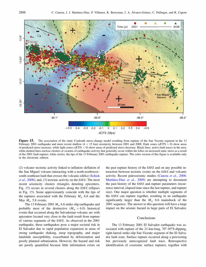
(2) volcano–tectonic activity linked to inflation–deflation ofthe San Miguel volcano interacting with a north-northwest–south-southeast fault that crosses the volcanic edifice (Schieket al., 2008); and, (3) tectonic activity on the ESFZ. The mostrecent seismicity clusters (triangles denoting epicenters,Fig. 15) occurs in several clusters along the ESFZ (ellipsesin Fig. 15). Some approximately coincide with the tips ofthe ruptures associated with the February Mw 6.6 and theMay Mw 5.8 events.
The 13 February 2001Mw 6.6 strike-slip earthquake andprobably most of the destructive (Mw > 6:0) historicalevents that occurred along the Salvadorian volcanic arc withepicenters located very close to the fault result from ruptureof various segments of the ESFZ. As observed in the 2001earthquake, these earthquakes pose a major societal risk inEl Salvador due to rapid population expansion in areas ofstrong earthquake shaking, steep topography, and majorlandslide susceptibility, exacerbated by deforestation andpoorly planned urbanization. However, the hazard and riskare poorly quantified because little information exists on
the past rupture history of the ESFZ and on any possible in-teraction between tectonic events on the ESFZ and volcanicactivity. Recent palesoeismic studies (Canora et al., 2008;Martínez-Díaz et al., 2009) are attempting to documentthe past history of the ESFZ and rupture parameters (recur-rence interval, elapsed time since the last rupture, and rupturesize). One major question is whether multiple segments ofthe ESFZ can rupture together, resulting in an earthquakesignificantly larger than the Mw 6.6 mainshock of the2001 sequence. The answer to this question will have a largeimpact on the seismic hazard in large parts of El Salvador.
Conclusions
The 13 February 2001 El Salvador earthquake was as-sociated with rupture of the 21-km-long, 70°–85°S-dipping,right-lateral strike-slip San Vicente segment of the El Salva-dor fault zone. Surface rupture occurred along a preexistingbut previously unrecognized fault trace. Retrospectiveidentification of coseismic surface ruptures, together with
Figure 15. The association of the static Coulomb stress-change model resulting from rupture of the San Vicente segment in the 13February 2001 earthquake and more recent shallow (h < 15 km) seismicity between 2001 and 2008. Dark zones (dCFS > 0) show areasof predicted stress increase, while light zones (dCFS < 0) show areas of predicted stress decrease. Black lines, active fault traces in the area;white dashed lines enclose clusters or swarms of earthquake activity that generally occur within the lobes on increased static stress as a resultof the 2001 fault rupture; white circles, the tips of the 13 February 2001 earthquake rupture. The color version of this figure is available onlyin the electronic edition.
2888 C. Canora, J. J. Martínez-Díaz, P. Villamor, K. Berryman, J. A. Álvarez-Gómez, C. Pullinger, and R. Capote

mapping of active fault traces of the ESFZ, analysis of focalmechanisms, and energy release in the 2001 sequence andmapping of the spatial distribution triggered landslides,provide a dataset with which to understand the context andhazard implications of the event. Coseismic surface rupturesassociated with the 13 February 2001 earthquake havebeen identified at five locations along the fault trace, witha maximum strike-slip displacement of 0.6 m along thesegment. The active fault map suggests the ESFZ consistsof at least four geometric segments. The 2001 earthquakeappears to have ruptured the entire the San Vicente segment,so the geometric segments may also define fault rupturesegments.
Seismicity that has occurred following the 2001 se-quence is highly correlated with arc volcanoes and with sec-tions of the ESFZ that are in areas of increased staticCoulomb stress changes resulting from the 2001 sequence,suggesting high levels of interaction between elements of thefault zone and the adjacent volcanic belt. Thus, the Lempaand Berlin fault segments located east of the 2001 rupturemay have been brought closer to failure because of the2001 sequence. Although few data exist concerning ruptureand recurrence parameters on segments of the ESFZ, thewidespread surface expression of faults in the Salvadorianlandscape, which is largely of late Quaternary age, suggestsyouthful movement on the faults and indicates that the prob-ability of future moderate earthquakes in El Salvador is high.
At Mw 6.6, the 2001 earthquake was only a moderate-magnitude event, yet it caused tectonic rupture, ground shak-ing, landslides, and secondary ground deformation, as wellas significant damage and numerous deaths and injuries.Thus, earthquake hazard and risk in the vicinity of the ESFZ,which straddles the city of San Salvador with a populationof more than 2 million, is high because even moderate-magnitude events can cause major damage, deaths, and in-juries in the region.
Data and Resources
Seismic catalog utilized in this work was provided by theMARN–SNET local network (available at http://www.snet.gob.sv/ver/sismologia, last accessed October 2009) and the U.S.Geological Survey (USGS)–National Earthquake Informa-tion Center catalogs (available at http://earthquake.usgs.gov/regional/neic/, last accessedApril 2009). Coulomb stressmodelling was carried out using COULOMB 3 from theUSGS. Focal mechanisms were extracted from the GlobalCentroid Moment Tensor Project database, formerly knownas the Harvard CMT catalog (searched using www.globalcmt.org/CMTsearch.html, last accessed May 2009) and fromhttp://earthquake.usgs.gov/earthquakes/eqarchives (last ac-cessed May 2009). Some plots were made using the GenericMapping Tools version 4.2.1 (www.soest.hawaii.edu/gmt;Wessel and Smith, 1998).
Acknowledgments
This research was funded by the Spanish Ministerio de Educación yCiencia. Project GEOTACTICA: Analysis of the active tectonics and volca-no-tectonic interactions in the El Salvador using geological, geotechnical,and geophysical data (Ref. CGL2009-14405-C02-02). We are also gratefulto Brian Sherrod and an anonymous reviewer for constructive review andcomments that helped to improve this work. We are grateful to colleaguesat SNET (Servicio Nacional de Estudios Territoriales): Manuel Díaz,Douglas Hernández, and Walter Hernández for their assistance in the fieldand for helping us find documents and photographs of the February 2001earthquake damage. C. Canora acknowledges financial support for thispublication provided by a predoctoral grant of the Universidad Complutensede Madrid, Spain. Funding for P. Villamor’s contribution was provided bythe New Zealand Foundation for Research, Science and Technology andGNS Science.
References
Agostini, S., G. Corti, C. Doglioni, E. Carminati, F. Innocenti, S. Tonarini,P. Manetti, G. Di Vincenzo, and D. Montanari (2006). Tectonic andmagmatic evolution of the active volcanic front in El Salvador: Insightinto the Berlin and Ahuachapan geothermal areas, Geothermics 35,368–408.
Aki, K., and G. P. Richards (1980). Quantitative Seismology: Theory andMethods, Vol. I and II, W. H. Freeman, San Francisco, 948 pp.
Álvarez-Gómez, J. A., P. T. Meijer, J. J. Martínez-Díaz, and R. Capote(2008). Constraints from finite element modeling on the active tec-tonics of northern Central America and the Middle America Trench,Tectonics 27, TC1008, doi 10.1029/2007TC002162.
Baum, R. L., A. J. Crone, D. Escobar, E. L. Harp, J. J. Major, M. Martinez,C. Pullinger, and M. E. Smith (2001). Assessment of landslide hazardsresulting from the February 13, 2001, El Salvador earthquake, USGSOpen-File Report, on-line edition, 01-119, available at http://pubs.usgs.gov/of/2001/ofr‑01‑0119/ (last accessed October 2009).
Benito, B., J. Cepeda, and J. J. Martínez-Díaz (2004). Analysis of the spatialand temporal distribution of the 2001 earthquakes, in Natural hazardsin El SalvadorW. I. Rose, J. J. Bommer, D. L. López, M. J. Carr, and J.J. Major (Editors), Geol. Soc. Am. Special Paper 375, 339–356.
Bommer, J., B. Benito, M. Ciudad-Real, A. Lemoine, M. López-Menjivar,R. Madariaga, J. Mankelow, P. Mendez-Hasbun,W.Murphy, M. Nieto-Lovo, C. Rodríguez, and H. Rosa (2002). The El Salvador earthquakesof January and February 2001: Context, characteristics and implicationsfor seismic risk, Soil Dynam. Earthq. Eng. 22, 389–418.
Buforn, E., A. Lemoine, A. Udias, and R. Madariaga (2001). Mecanismofocal de los terremotos de El Salvador, in Memorias 2nd CongresoIberoamericano de Ingeniería Sísmica, Madrid, Spain, 16–19 October2001,J. M. Martínez-Guevara (Editor), 115–118.
Canora, C., J. J. Martínez-Díaz, P. Villamor, K. Berryman, R. Capote,J. A. Álvarez-Gómez, M. Bejar, M. Tsige, and C. Pullinger (2008).First paleoseismic studies on the El Salvador fault zone, 33rd Inter-national Geological Congress, Oslo, Norway, 5–14 August 2008.
Correa-Mora, F., C. DeMets, D. Alvarado, H. L. Turner, G. Mattioli,D. Hernández, C. Pullinger, M. Rodriguez, and C. Tenorio (2009).GPS-derived coupling estimates for the Central America subductionzone and volcanic arc faults: El Salvador, Honduras and Nicaragua,Geophys. J. Int. 179, no. 3 1279–1291.
Corti, G., E. Carminati, F. Mazzarini, and M. O. Garcia (2005). Activestrike-slip faulting in El Salvador, Central America, Geology 33,989–992.
Chinnery, M. A. (1963). The stress changes that accompany strike-slipfaulting, Bull. Seismol. Soc. Am. 53, no. 5 921–932.
Das, S., and C. Henry (2003). Spatial relation between main earthquake slipand its aftershock distribution, Rev. Geophys. 41, no. 3 1013.
Das, S., and C. Scholz (1981). Off-fault aftershock clusters caused by shearstress increase? Bull. Seismol. Soc. Am. 71, 1669–1675.
Geological and Seismological Analysis of the 13 February 2001 Mw 6.6 El Salvador Earthquake 2889

DeMets, C. (2001). A new estimate for present-day Cocos–Caribbean platemotion: Implications for slip along the Central American volcanic arc,Geophys. Res. Lett. 28, 4043–4046.
DeMets, C., R. G. Gordon, and D. F. Argus (2008). MOREL: A newestimate for geologically recent plate motions, AGU Fall Meeting,San Francisco, California, 15–19 December 2008.
Deng, J., and L. R. Sykes (1997). Evolution of the stress field in southernCalifornia and triggering of moderate-size earthquakes: A 200-yearperspective, J. Geophys. Res. 102, 9859–9886.
Dewey, J. W., R. A. White, and D. A. Hernández (2004). Seismicity andtectonic of El Salvador, in Natural Hazards in El Salvador W. I. Roseet al. (Editors), Geological Society of America Special Paper 375,363–378.
García-Florez, I.. (2008). Deslizamientos inducidos por terremotos: caso deEl Salvador,MSc Thesis, Universidad Complutense de Madrid, 51_pp.
Guzmán-Speziale, M., and J. J. Meneses-Rocha (2000). The North America–Caribbean plates boundary west of theMotagua–Polochic fault system:A fault jog in southeastern Mexico, J. S. Am. Earth Sci. 13, 459–468.
Guzmán-Speziale, M., W. D. Pennington, and T. Matumoto (1989). Thetriple junction of the North America, Cocos, and Caribbean plates:Seismicity and tectonics, Tectonics 8, 981–997.
Harris, R. A. (1998). Introduction to special section: Stress triggers, stressshadows, and implications for seismic hazard, J. Geophys. Res. 103,347–358.
Isacks, B., and M. Baranzagi (1977). Geometry of Benioff zones: Lateralsegmentation and downwards bending of the subducted lithosphere,in Island Arcs, Deep Sea Trenches, and Back-Arc Basins, MauriceEwing Series, Vol. I, M. Talwani and W. C. Pitman (Editors),American Geophysical Union , Washington, D.C., 99–114.
Jibson, R. W., and A. J. Crone (2001). Observations and recommendationsregarding landslide hazards related to the January 13, 2001 M-7.6 ElSalvador Earthquake, U.S. Geol. Surv. Open-File Report, on-line edi-tion, 01-141, available at http://pubs.usgs.gov/of/2001/ofr‑01‑0141/(last accessed April 2009).
Jaume, S. C., and L. R. Sykes (1992). Changes in state of stress on the south-ern San Andreas fault resulting from the California earthquakesequence of April to June 1992, Science 258, no. 5086 1325–1328.
Kanamori, H. (1977). The energy release in great earthquakes, J. Geophys.Res. 82, no. 20 2981–2987.
Kikuchi, M., and Y. Yamanaka (2001). EIC Seismological Notes N° 99,Earthquake Research Institute, Tokyo, Japan, available throughhttp://www.eri.u‑tokyo.ac.jp/sanchu/Seismo_Note/index‑e.html (lastaccessed April 2009).
King, G. C. P., R. S. Stein, and J. Lin (1994). Static stress changes and thetriggering of earthquakes, Bull. Seismol. Soc. Am. 84, 935–953.
Lyon-Caen, H., E. Barrier, C. Lasserre, A. Franco, I. Arzu, M. Chiquin,L. M. Chiquin, T. Duquesnoy, O. Flores, O. Galicia, J. Luna,E. Molina, O. Porras, J. Requena, V. Robles, J. Romero, and R. Wolf(2006). Kinematics of the North American–Caribbean-Cocos plates inCentral America from new GPS measurements across the Polochic–Motagua fault system, Geophys. Res. Lett. 33, L19309, doi 10.1029/2006GL027694.
Martínez-Díaz, J. J., J. A. Álvarez-Gómez, B. Benito, and D. Hernández(2004). Triggering of destructive earthquakes in El Salvador, Geology32, 65–68.
Martínez-Díaz, J. J., C. Canora, P. Villamor, R. Capote, J.A. Álvarez-Gómez, K. Berryman, M. Béjar, and M. Tsige (2009). Tectonicinterpretation of the 13 February 2001, Mw 6.6, El Salvador earth-quake: New evidences of coseismic surface rupture and paleoseismicactivity, EGU General Assembly, Vienna, Austria, 19–24 April 2009.
Okada, Y. (1992). Internal deformation due to shear and tensile faults in ahalf-space, Bull. Seismol. Soc. Am. 82, no. 2 1018–1040.
Plafker, G. (1976). Tectonic aspects of the Guatemala earthquake of4 February 1976, Science 193, no. 4259 1201–1208.
Rose, W. I., F. M. Conway, C. R. Pullinger, A. Deino, and W. C. McIntosh(1999). An improved age framework for late Quaternary siliciceruptions in northern Central America, Bull. Vulcanol. 61, 106–120.
Schiek, C. G., J. M. Hurtado, J. Aaron, A. Velasco, S. M. Buckley, B. Smith-Konter, and D. Escobar (2008). Determining volcanic deformation atSan Miguel volcano, El Salvador by integrating radar interferometryand seismic analyses, Fall Meet. Suppl., Abstract U51A-0018, EosTrans. AGU, 89, no. 53.
Scholz, C. H. (1994). A reappraisal of large earthquake scaling, Bull.Seismol. Soc. Am. 84, no. 1 215–218.
Selvaggi, G., B. Castello, and R. Azzara (1997). Spatial distribution of scalarseismic moment release in Italy (1983–1996): Seismotectonic impli-cations for the Apennines, Ann. Geophys. XL, no. 6 1565–1578.
Sylvester, A. G. (1988). Strike-slip faults, Geol. Soc. Am. Bull. 100, 1666–1703.
Toda, S., R. S. Stein, P. A. Reasenberg, and J. H. Dieterich (1998). Stresstransferred by theMw � 6:5Kobe, Japan, shock: Effect on aftershocksand future earthquake probabilities, J. Geophys. Res. 103, no. 24543–565.
Tsige, M., I. García-Flórez, R. Capote, and R. M. Mateos (2008). Losgrandes deslizamientos inducidos por los terremotos de El Salvadordel 2001: Control litológico y estructural, Geogaceta 10, 1567–5172.
Wessel, P., andW. H. F. Smith (1998). New, improved version of the GenericMapping Tools Released, EOS Trans. AGU 79, 579.
Wells, D. L., and K. J. Coppersmith (1994). New empirical relations amongmagnitude, rupture length, rupture width, rupture area and surface dis-placement, Bull. Seismol. Soc. Am. 84, no. 4 974–1002.
White, R. A., and D. H. Harlow (1993). Destructive upper crustal earth-quakes of Central America since 1900, Bull. Seismol. Soc. Am. 83,1115–1142.
White, R. A., D. H. Harlow, and S. Álvarez (1987). The San Salvador earth-quake of October 10, 1986: Seismological aspects and other recentlocal seismicity, Earthq. Spectra 3, 419–434.
Departamento de GeodinámicaFacultad de Ciencias GeológicasUniversidad Complutense de MadridCiudad Universitaria28040 Madrid, [email protected]
(C.C., J.J.M., R.C.)
GNS ScienceLower Hutt, New [email protected]
(P.V., K.B.)
Instituto de Hidráulica Ambiental “IH Cantabria”Universidad de CantabriaE.T.S.I. Caminos, Canales y PuertosSantander, Spain
(J.A..-G.)
LaGeo.S.A. de C.V.Santa TeclaLa Libertad, El Salvador
(C.P.)
Manuscript received 11 December 2009
2890 C. Canora, J. J. Martínez-Díaz, P. Villamor, K. Berryman, J. A. Álvarez-Gómez, C. Pullinger, and R. Capote


![Rights / License: Research Collection In Copyright - Non ...26082/eth-26082-02.pdfis possible to develop interesting, practical systems with little man-power [134]. The outcome of](https://img.dokumen.tips/doc/110x75/5f86202ecdfbf4406b1e0c23/rights-license-research-collection-in-copyright-non-26082eth-26082-02pdf.jpg)