Embed Size (px)
Citation preview

1
GEOLOGIC MAP OF THE
BLACK HILL 7.5-MINUTE QUADRANGLE,
SOCORRO COUNTY, NEW MEXICO
ByAndrew P. Jochems and Daniel J. Koning
June 2019
New Mexico Bureau of Geology and Mineral ResourcesOpen-file Digital Geologic Map OF-GM 274
Scale 1:24,000
This work was supported by the U.S. Geological Survey, National Cooperative Geologic Mapping Program (STATEMAP) under USGS Cooperative Agreement G18AC00201
and the New Mexico Bureau of Geology and Mineral Resources.
New Mexico Bureau of Geology and Mineral Resources, New Mexico Institute of Mining and Technology, 801 Leroy Place, Socorro, New Mexico, 87801-4796
The views and conclusions contained in this document are those of the authors and should not be interpreted as necessarily representing the official policies,
either expressed or implied, of the U.S. Government or the State of New Mexico.

2
CONTENTSEXECUTIVE SUMMARY .............................................................................................................................................3
INTRODUCTION ............................................................................................................................................................4
GEOLOGIC SETTING ...................................................................................................................................................5
METHODS .........................................................................................................................................................................6
STRATIGRAPHY .............................................................................................................................................................6
Paleozoic Rocks .....................................................................................................................................................6
Paleogene Volcanic Rocks....................................................................................................................................7
Early Pleistocene-Miocene Basin Fill .................................................................................................................9
Quaternary Deposits (Post-Palomas Formation) .............................................................................................11
Erosional Surfaces .................................................................................................................................................12
STRUCTURAL GEOLOGY ..........................................................................................................................................12
HYDROGEOLOGY ........................................................................................................................................................12
REFERENCES ..................................................................................................................................................................14
Appendix A: Detailed unit descriptions..........................................................................................................................19
Appendix B: 40Ar/39Ar data ...............................................................................................................................................29
Appendix C: Clast count data ...........................................................................................................................................32
Appendix D: Maximum clast size data ...........................................................................................................................37
Appendix E: Paleocurrent data.........................................................................................................................................41
3
coarse-grained piedmont facies in the west to sandy axial-fluvial facies in the east. Younger deposits (middle Pleistocene to Holocene) include alluvial fans, well-defined suites of terraces in the major drainages, and valley-floor alluvium. A series of erosional surfaces have formed on the Palomas Formation north of Crawford Hollow. Shallow aquifers of moderate- to high-quality groundwater are likely to be found in late Quaternary valley fill and deeper groundwater sources may exist in the Palomas Formation, particularly the sandy, uncemented axial-fluvial facies.
The Palomas Formation piedmont facies units exposed in the quadrangle were deposited on hanging-wall distributary fan systems emanating from the foothills of the southeastern San Mateo Mountains. Of note is the large Nogal Canyon paleofan with a northern margin near Crawford Hollow and a major control on the modern, fanning topography in the southern 2/3 of the quadrangle. Modern Nogal Canyon apparently runs south of the main axis of this paleofan. The Palomas Formation axial-fluvial units were deposited in braided channels or floodplain environments of the ancestral Rio Grande. In total, six conformable member-rank units were mapped for the Palomas Formation.
The lower piedmont facies (Tppl) consists of 35-45 m of gravel/conglomerate containing pebbles through boulders deposited by debris flows in proximal alluvial fan environments. This unit is best exposed in low-lying ridges around the southwestern quadrangle. The undivided lower to middle piedmont facies (QTppml) was mapped in parts of Nogal Canyon not accessed due to land permission restrictions, but probably consists of <60 m of silty or sandy sediment and gravel that may coarsen to the west. The middle piedmont facies (QTppm) is dominated by extra-channel silt and mud with subordinate fluvial or debris-flow sand and gravels and minor calcareous ciénega deposits found at distal fan positions in the eastern quadrangle. The middle piedmont facies have a maximum thickness of at least 60 m. The upper piedmont facies (Qppu) includes interbedded gravel bodies, pebbly silt-sand, silt, and mud with a maximum thickness of 85 m. In Nogal Canyon, near and upstream of Interstate 25, this unit consists almost entirely of stacked gravel deposits deposited by debris flows. It is distinguished from the middle piedmont facies by redder colors, a greater proportion of matrix clay, and sheet-like geometries among its gravel beds.
The axial-fluvial facies of the Palomas Formation (QTpa)
EXECUTIVE SUMMARYThe Black Hill 7.5-minute quadrangle is located in the southern part of the San Marcial Basin, an east-tilted half graben in the southern Rio Grande rift. The map area includes uplands cored by Paleogene volcanic and Paleozoic carbonate rocks in the southwest, a large paleofan extending from the foothills of the San Mateo Mountains in the central and southern parts of the quadrangle, and a number of tributaries to the Rio Grande. Among the latter, from north to south, are: Sheep Canyon, Lumbre Canyon, Crawford Hollow, Silver Canyon, Nogal Canyon, and Chaunte Canyon. Nogal Canyon forms an impressive gorge crossed by Interstate 25 and features local relief of up to 185 m where it runs adjacent to bedrock hills in the southwestern quadrangle.
The oldest rocks exposed in the quadrangle are Paleozoic limestones thought to be Pennsylvanian in age (*u); these underlie two hills south of Nogal Canyon and several small exposures in the northwestern part of the map area. Eocene to Oligocene volcanic rocks underlie prominent hills and ridges along New Mexico Highway 1 and south of Crawford Hollow to the southern quadrangle boundary. These include a trachyandesite (Tta), Tuff of Rocque Ramos Canyon (Trr), La Jencia Tuff (Tlj), and Vicks Peak Tuff (Tvp) as well as a minor volcaniclastic unit (Tvs). All tuffs are outflow facies although the Vicks Peak is within 6-8 km of the southeastern margin of its source caldera.
Early Pleistocene through Miocene basin-fill deposits dominate the geology of the quadrangle. Fine-grained basin fill inferred to be Miocene in age is found along Nogal Canyon in its deeper reaches near the western quadrangle boundary. Plio-Pleistocene gravel, sand, silt, and clay belonging to the Palomas Formation lie above this older basin fill, attaining a minimum thickness of 180 m. The Palomas Formation transitions from mostly
Note on Private-Land Access in the Map Area
The Black Hill 7.5-minute quadrangle contains significant acreages of public land (Bureau of Land Management or State of New Mexico) but parcels of private land do exist, primarily along Nogal Canyon and west of New Mexico Highway 1. We ask that all users of this map obtain permission from local owners before entering their lands.

4
begins in the northwestern part of the quadrangle. From north to south, the major drainages of the quadrangle are Sheep Canyon, Lumbre Canyon, Crawford Hollow, Silver Canyon, Nogal Canyon, and Chaunte Canyon. Nogal Canyon forms an impressive gorge crossed by Interstate 25 and features local relief of up to 185 m where it runs adjacent to bedrock hills in the western quadrangle. The highest location in the quadrangle is 1738 m (5702 ft) above sea level (asl) at VABM Glorietta (13S 292590 mE, 3715082 mN NAD83). The lowest point is 1359 m (4459 ft) asl where a small wash exits the quadrangle between Nogal and Silver Canyons (13S 302530 mE, 3708882 mN NAD83).
The Black Hill quadrangle has an arid to semiarid climate. The summer months (June through August) experience mean temperatures of 23.6-25.6 °C (74.4-78.1 °F). The winter months (December through February) experience mean temperatures of 3.2-6.1 °C (37.8-43.0 °F). Mean annual precipitation is 25.1-25.9 cm (9.9-10.2 in), approximately half of which falls during the North American monsoon in the months of July through September. Climate data are from the Bosque del Apache and Rienhardt Ranch stations (ID# 291138 and 297423, respectively) in the NWS Cooperative network and averaged over the years 1981-2010 (Western Regional Climate Center, 2019).
The geology of the Black Hill quadrangle was previously mapped at 1:200,000-scale by Osburn (1984). Surrounding quadrangles mapped at a scale of 1:24,000 include the Romero Canyon quadrangle to the south (Cikoski, 2018) and a small portion of San Juan Peak to the northwest (Ferguson, 1986). The Paraje Well quadrangle to the east is currently being mapped at 1:24,000 by the New Mexico Bureau of Geology & Mineral Resources as part of its STATEMAP program.
This report includes a summary of the geologic setting before describing mapped units and their depositional settings by age, oldest to youngest. The structural geology of the area is briefly discussed, as are hydrogeologic implications for mapped basin-fill units. Detailed unit descriptions, 40Ar/39Ar age data, clast count data, maximum clast size, and paleocurrent measurements are provided as appendices.
consists of fine- to coarse-grained, quartzose sand with subordinate gypsiferous mud and pebble gravel beds, the latter containing exotic clast lithologies such as chert, granite, and quartzite. Its total thickness is unknown but projections of contacts from cross-section A-A’ and well data indicate a minimum thickness of 70-75 m in the Silver Canyon area. Vertebrate fossils recovered from channel-margin deposits of unit QTpa indicate a Blancan age for the unit, with its top younger than ~2.7 Ma. A thin, fine-grained subunit (QTpaf) found in Crawford Hollow consisting of massive mud represents floodplain deposition and interfingers with the middle piedmont facies. In most of the quadrangle, the upper piedmont facies as prograded over the axial-fluvial facies, with few if any interfingering relationships observed.
Structures in the Black Hill quadrangle are indicative of regional extensional tectonics observed throughout the Rio Grande rift. A series of normal faults in the southwestern quadrangle are responsible for the volcanic and Paleozoic carbonate bedrock hills there and have an average strike of approximately 007°. In the northeastern map area, several faults striking approximately 345° form scarps up to 4-4.5 m high on the aggradational surface of the Palomas Formation as well as local erosional surfaces and middle Pleistocene terrace deposits near Crawford Hollow and Silver Canyon. These include the Black Hill fault crossing Interstate 25 north of Silver Canyon. The faults are probably 130-800 ka in age and have very low slip rates (<0.05 mm/yr).
INTRODUCTIONThis report accompanies the Geologic Map of the Black Hill 7.5-Minute Quadrangle, Socorro County, New Mexico (NMBGMR OF-GM 274). Its purpose is to discuss the geologic setting and history of this area, and to identify and explain significant stratigraphic and structural relationships uncovered during the course of mapping.
The Black Hill 7.5-minute quadrangle is located in the southern part of the San Marcial Basin, an east-tilted half graben in the southern Rio Grande rift. It is bordered on the west by foothills of the southeastern San Mateo Mountains and is characterized by valleys of modest to considerable relief carved by east- or southeast-flowing tributaries to the Rio Grande. These drainages mostly head in the San Mateo Mountains or their foothills except for smaller washes such as Lumbre Canyon, which
5
Palomas and Hatch-Rincon Basins to the south (Hawley et al., 1969; Seager et al., 1971).
Plio-Pleistocene basin fill of the Palomas Formation (upper Santa Fe Group) overlies the lower to middle Miocene deposits with angular unconformity. Named by early workers for extensive gravelly units in the Palomas Basin (Gordon and Graton, 1907; Gordon, 1910; Harley 1934) and formally defined by Lozinsky and Hawley (1986a, b), the Palomas Formation underlies most of the land surface of the Black Hill quadrangle. Six conformable, member-rank units can differentiated by color, texture, clast lithology, and degree of cementation.
The Palomas Formation piedmont facies units were deposited on hanging-wall distributary fan systems emanating from the foothills of the southeastern San Mateo Mountains, including a large paleofan of Nogal Canyon. Proximal through distal fan lithofacies are all represented among the Palomas piedmont units. Distal piedmont lithofacies interfinger with sandy beds containing pebbles of extra-basin lithologies (quartzite, granite, and chert) along the eastern quadrangle boundary. These represent axial-fluvial lithofacies deposited in braided channels or floodplain environments of an ancestral Rio Grande that integrated to southern New Mexico ~5 Ma (Mack et al., 2006; Koning et al. 2016, 2018).
The surface of the Nogal Canyon paleofan represents the local culmination of deposition of Palomas Formation basin fill, predating incision by the Rio Grande and its tributaries beginning in the middle Pleistocene. Aggradational geomorphic surfaces on lower Pleistocene basin fill in the Rio Grande rift vary somewhat in age but they generally date to ~0.8 Ma (Mack et al., 1993, 1998). Assuming the Nogal Canyon paleofan surface has a similar age, it is correlative to the Cuchillo surface of the Palomas and Engle Basins (Lozinsky, 1986; Lozinsky and Hawley, 1986a, b; Maxwell and Oakman, 1990; McCraw and Love, 2012) and the Las Cañas and Sedillo Hill surfaces of the Socorro Basin (McGrath and Hawley, 1987). North of Crawford Hollow, five erosional surfaces cutting the top of the Palomas Formation can be identified and inset middle-late Pleistocene and Holocene deposits are found throughout most drainages crossing the map area. The inset deposits indicate at least 4-6 alternating intervals of backfilling and incision.
GEOLOGIC SETTINGThe Black Hill quadrangle is located in the southern Rio Grande rift, a series of en echelon basins stretching from northern Colorado to northern Mexico (Chapin and Cather, 1994). The quadrangle includes the southern part of the San Marcial Basin, an east- to southeast-tilted half-graben containing Miocene through early Pleistocene basin fill of the Santa Fe Group. Unlike the neighboring Engle Basin to the south, the San Marcial Basin lacks an obvious footwall-bounding uplift. Its (south)eastward tilt is inferred from stratigraphic dips and its half-graben geometry is inferred from Bouguer gravity anomaly data that implies an abrupt north-northeast-trending boundary between the San Marcial and Jornada del Muerto Basins (Keller, 1983; Kucks et al., 2001). Range-bounding faults to the north and south support this interpretation (Geddes, 1963; Nelson, 1986), as does a comparatively thinner package of Santa Fe Group basin fill underlying the western Jornada del Muerto Basin (Kelley, 1952).
The San Marcial Basin is bordered on the north and west by the Magdalena and San Mateo Mountains, both comprised chiefly of Paleogene volcanic rocks of the eastern Mogollon-Datil volcanic field with lesser proportions of intrusive bodies and Paleozoic sedimentary lithologies. The southeast San Mateo Mountains are the source area for most of the large drainages in the Black Hill quadrangle, contributing bedload clasts of felsic tuffs, flows, and intrusive rocks.
Prominent hills and low ridges in the southwest part of the map area are cored by Paleogene volcanic and Paleozoic carbonate rocks, uplifted along normal faults inferred to relate to one or more phases of Rio Grande rift extension beginning in the early Miocene. Other hills in the central quadrangle are formed of volcanic lithologies, including the eponymous Black Hill just east of New Mexico Highway 1. These features are uplifted along buried faults or faults with subtle surface expression and resemble erosional inselbergs.
Lower to middle Santa Fe Group basin-fill units exposed in Nogal Canyon record earlier phases of extension in the Rio Grande rift. These strata lie in both depositional and fault contact with Paleozoic carbonates and Eocene-Oligocene volcanic units, and appear to have filled in paleotopographic relief formed on the latter rocks west of Highway 1. The Santa Fe Group strata predating the Palomas Formation may be in part correlative to the middle to upper Miocene Rincon Valley Formation of the
6
291315 mE, 3721845 mN NAD83) can be physically traced to the Paleozoic section at Bell Hill in the Steel Hill 7.5-minute quadrangle to the west. Kottlowski (1960) mapped this exposure as Pennsylvanian in age with Desmoinesian to Missourian fusulinids, although his stratigraphic section contains several discontinuities among marker fossils. Lucas et al. (2017) measured four sections near Bell Hill, none of which cross the small outcrop on the Black Hill quadrangle. However, the outcrop appears to correlate to the lower part of their section A1 on the upthrown side of a NE-trending fault. If correct, this correlation implies that the outcrop on the Black Hill quadrangle consists of limestones and perhaps fine-grained sandstone belonging to the Atokan Red House and Desmoinesian Gray Mesa Formations (Lucas et al., 2017).
Two hills underlain by limestone with minor covered intervals were mapped along Nogal Canyon near the western quadrangle boundary. The smaller hill at 13S 291360 mE, 3714799 mN NAD83 was not physically surveyed due to land access restrictions; it was vantage-mapped in the field and compared to the larger hill to the east using high-resolution aerial imagery. The larger hill is underlain by a succession of medium to dark gray, non- to occasionally cherty mudstone, wackestone, and packstone with fossils of nautiloids, bivalves, echinoderms, and sponge spicules. Some beds contain oval-shaped grains up to 3.5 mm long that are nearly always recrystallized but inferred to be fusulinids. Covered intervals are mostly underlain by shale. The lack of siliciclastic beds and fossil assemblages suggest a marine-shelf depositional environment (Lucas et al., 2012, 2016; Nelson et al., 2013). The Pennsylvanian section at Bell Hill is at least 495 m thick (Lucas et al., 2017), but <240 m is exposed in the Black Hill quadrangle at Nogal Canyon.
Osburn (1984) mapped the Nogal Canyon exposures as Permian in age but his map does not include discussion of this designation. Kottlowski (1960, p. 42) and Farkas (1969, p. 9) assign a Pennsylvanian age to the rocks in and along Nogal Canyon based on lithologic similarities to Kottlowski’s section at Bell Hill. Indeed, the section of carbonate rocks at 13S 292400 mE, 3714410 mN NAD83 consists of ledge-forming, cherty, medium-bedded packstone and wackestone similar to the Elephant Butte and Whiskey Canyon Members of the Gray Formation as described by Lucas et al. (2017, p. 267); carbonate conglomerate of the overlying Garcia Member was not observed. Additionally, no siliciclastic red beds of the Permian Abo Formation as described at
METHODSGeologic mapping of the Black Hill quadrangle involved traditional field techniques (Compton, 1985) coupled with newer digital approaches. Stereogrammetry software (Stereo Analyst for ArcGIS 10.1, an ERDAS extension, version 11.0.6) permitted accurate placement of geologic contacts using aerial photography obtained from the National Agricultural Imagery Program (NAIP). Planimetric and vertical accuracy of this dataset is approximately 5 m (USDA, 2008). Contacts plotted using stereogrammetry were then field-checked.
Descriptions of individual units were made in the field utilizing both visual and quantitative estimates based on outcrop and hand lens inspection. For clastic sediments, grain sizes follow the Udden-Wentworth scale and the term “clast(s)” refers to the grain size fraction greater than 2 mm in diameter (Udden, 1914; Wentworth, 1922). Carbonate rocks are classified according to Dunham (1962). Descriptions of bedding thickness follow Ingram (1954). Colors of sediment are based on visual comparison of dry samples to Munsell soil color charts (Munsell Color, 2009).
For volcanic units, grain or phenocryst size was described following the conventions of Wentworth (1922), Fisher (1961), and White and Houghton (2006). Color was estimated visually on both fresh and weathered surfaces. Other textural terms were assigned according to definitions in Winter (2010, p. 49-52).
Surface characteristics and relative landscape position were used in mapping middle Pleistocene to Holocene stream-terrace, alluvial-fan, and valley-floor deposits. Surface characteristics dependent on age include desert pavement development, clast varnish, soil development, and preservation of original bar-and-swale topography. Soil horizon designations and descriptive terms follow those of Birkeland and others (1991), Birkeland (1999), and Soil Survey Staff (1999). Stages of pedogenic calcium carbonate morphology follow those of Gile and others (1966) and Birkeland (1999).
STRATIGRAPHYPaleozoic RocksPaleozoic carbonates (*u) are exposed in several hills south of Nogal Canyon as well as sparse outcrops in the northwest quadrangle. The northernmost of these (13S

7
The Tuff of Rocque [sic] Ramos Canyon (Trr) was named by Harrison (1990) for exposures in Roque Ramos Canyon in the eastern Sierra Cuchillo ~35 km southwest of the map area. It is found at Black Hill and a series of low hills to its west as well as underlying the Vicks Peak (and, locally, La Jencia) tuffs south of Nogal Canyon. The Tuff of Rocque Ramos Canyon is a light-gray to white or pinkish-gray to reddish-brown, moderately to densely welded ash-flow tuff. Cikoski et al. (2010) describe an upper, moderately welded unit with <7% phenocrysts and a lower, densely welded unit with 15-20% phenocrysts (mostly sanidine) in the Indian Well Wilderness 7.5-minute quadrangle 30-35 km northeast of the map area. In tandem, these units are up to 60 m thick. In the Black Hill quadrangle, phenocrysts occupy 15-40% of the surface area and are composed mainly of fine to medium sanidine with subordinate plagioclase and trace to 7% biotite, the latter commonly with coppery luster. Whole-rock geochemistry suggests that the unit is trachytic to rhyolitic with SiO2 and Na2O + K2O values of 68.7 and 10.5 wt %, respectively (Table 1). Harrison (1990) noted similar geochemistry in the northern Black Range. The unit contains 1-5% pumice that are 1-10 cm long and relatively undeformed to highly flattened; occasional compaction foliation is more poorly developed than that of the La Jencia Tuff. At Black Hill, <10-15% pebble-sized lithic andesite fragments are present. South of Nogal Canyon, the unit includes a reddish-brown, ledge-forming, volcaniclastic facies underlying welded, sanidine-rich tuff. These facies have a mostly matrix-supported texture with subangular to subrounded, pebble-sized pumice and minor aphanitic andesite clasts. Cikoski et al. (2010) reported an average 40Ar/39Ar age of 35.75 ± 0.01 Ma and 35.72 ± 0.01 Ma were obtained for the Tuff of Rocque Ramos Canyon in the Black Hill quadrangle (Appendix B). The unit has been correlated with the Bell Top 4 tuff (McIntosh et al., 1991), for which Clemons (1975) suggested a source area in the Sierra de las Uvas near Hatch, New Mexico. However, McIntosh (1989) suggested that the Emory caldera of the more proximal Black Range may be the source of the Tuff of Rocque Ramos Canyon; no definitive source caldera has yet been identified. The tuff is <80-100 m thick in the Black Hill quadrangle.
A thin (<7-10 m) bed of the La Jencia Tuff (Tlj) underlies the Vicks Peak Tuff in the southwestern corner of the quadrangle (13S 293845 mE, 3709950 mN NAD83). The bed consists of purplish-brown to gray, welded, rhyolitic ash-flow tuff with 2-8% phenocrysts of fine to medium
Bell Hill (Kottlowski, 1960; Furlow, 1965; Lucas et al., 2017) are found at Nogal Canyon. Thus, we prefer the interpretation that these strata are Pennsylvanian in age.
Paleogene Volcanic RocksFour extrusive volcanic units are mapped on the Black Hill quadrangle as well as a volcaniclastic unit and an undivided volcanic unit (Tvu). The extrusive units include a trachyandesite, Tuff of Rocque Ramos Canyon, La Jencia Tuff, and Vicks Peak Tuff, each erupted from volcanic centers of the Mogollon-Datil volcanic field (Chapin et al., 1978, 2004; Elston, 1989). These units are upper Eocene to lower Oligocene in age; the Vicks Peak and La Jencia tuffs belong to the 29-24 Ma Mogollon Group and the Tuff of Rocque Ramos Canyon and trachyandesite belong to the 39-32 Ma Datil Group (Cather et al., 1994). Note that reported 40Ar/39Ar ages are calculated using a revised sanidine monitor age of 28.201 Ma for the Fish Canyon Tuff as advocated by Kuiper et al. (2008).
A trachyandesite (Tta) unconformably(?) underlies the Tuff of Rocque Ramos Canyon on a small hill south of Nogal Canyon (13S 293135 mE, 3713448 mN NAD83). Its contact with the carbonate strata to the west is inferred to occur along a buried SE-down structure; assuming the limestones are lower to middle Pennsylvanian in age, a fault is required to explain at least several hundred meters of missing upper Paleozoic (mostly Permian) and Eocene volcanic and volcaniclastic rocks (e.g., Spears Group). The trachyandesite consists of purplish brown, vesicular, massive to moderately flow-foliated, aphanitic lava with sparse phenocrysts of plagioclase and pyroxene with perhaps trace hornblende and olivine(?). Whole-rock geochemistry of the unit returned SiO2 and Na2O + K2O values of 59.2 and 9.9 wt %, respectively (Table 1). Its geochemistry is similar to the Luna Peak (trachy)andesite of the Red Rock Ranch Formation in the Monticello area (Koning et al., 2014), but its phenocryst content is more akin to the overlying Red Rock Arroyo andesite. The Red Rock Ranch Formation is upper Eocene in age (Farkas, 1969; Hermann, 1986; Koning et al., 2014). Ferguson (1986) described a basaltic andesite similar in appearance to the trachyandesite in the east-central San Mateo Mountains; however, he speculates that the unexposed base of this andesite lies above the 32.0 Ma Hells Mesa Tuff (Ferguson, 1988, p. 4) so correlation between the two units is doubtful. The exposed thickness of the trachyandesite in the map area is 65-70 m.

8
Named by Farkas (1969) for exposures in the nearby San Mateo Mountains, the Vicks Peak Tuff (Tvp) is one of the most extensive tuff units erupted from the northeastern Mogollon-Datil field (McIntosh et al., 1992). It comprises most of the hills west of Highway 1 in the southwest part of the quadrangle and is also found atop a small knoll west of Black Hill. In most places on the quadrangle, the Vicks Peak overlies the Tuff of Rocque Ramos Canyon, representing an unconformity of nearly 7 million years. The Vicks Peak overlies a thin (<6 m), poorly exposed bed of volcaniclastic sediment (Tvs) west of Black Hill; this deposit lies atop the Tuff of Rocque Ramos Canyon.
In the Black Hill quadrangle, the Vicks Peak Tuff is a light-gray, occasionally columnar-jointed, crystal-poor, rhyolitic ash-flow tuff. Phenocrysts include trace to 3% sanidine, trace to 1% mafics, and trace quartz set in a devitrified matrix. Whole-rock SiO2 and Na2O + K2O contents are 75.9 and 9.1 wt %, respectively (Table 1).
sanidine and biotite. Brown (1972) notes that outflow facies of the La Jencia (his “lower tuff of Bear Springs”) may also contain smoky quartz and plagioclase crystals as well as andesitic to rhyolitic lithics; a few altered lithics are observed in the limited exposures of the map area. Whole-rock SiO2 and Na2O + K2O contents are 69.9 and 10.6 wt %, respectively (Table 1). Abundant fiamme and stretched vesicles and lapilli exhibit highly variable length:width ratios, ranging from 3:1 to 76:1. The La Jencia Tuff was erupted from the Sawmill Canyon caldera in the Magdalena Mountains ~40 km north of the Black Hill quadrangle (Osburn and Chapin, 1983; Chapin et al., 2004). Given its limited spatial extent, the La Jencia Tuff in the map area is inferred to have filled a paleotopographic low formed on the Tuff of Rocque Ramos Canyon. An 40Ar/39Ar age of 29.00 ± 0.02 Ma was obtained (Appendix B), closely matching previously reported ages (McIntosh et al., 1991; Chapin et al., 2004).

9
et al., 1994; Connell, 2008). The lower to middle Santa Fe Group on the Black Hill quadrangle is at least 90 to perhaps 100s of meters thick but sparse well control and a lack of high-resolution geophysical data prohibit an accurate estimate.
Plio-Pleistocene gravel, sand, silt, and clay belonging to the Palomas Formation (upper Santa Fe Group) lies above the older basin fill in the map area, attaining a minimum thickness of 180 m. The term “Palomas” was first applied to outcrops of upper Santa Fe Group basin fill by Gordon and Graton (1907), Gordon (1910), and Harley (1934). Gordon (1910, plate XII) used the term for surficial sediments throughout the Engle, Jornada del Muerto, Palomas, and San Marcial Basins. Lozinsky and Hawley (1986a) formally defined the Palomas Formation and detailed descriptions of the unit are presented in Lozinsky and Hawley (1986a, b) and Lozinsky (1986). Fossil data (summarized by Morgan and Lucas, 2012), radiometric ages (Bachman and Mehnert, 1978; Seager et al., 1984; Jochems, 2015; Koning et al., 2015, 2016, 2018), and magnetostratigraphic data (Repenning and May, 1986; Mack et al., 1993, 1998) indicate an age range of ~5.0-0.8 Ma for the Palomas Formation.
The Palomas Formation is divided into six conformable, member-rank units on the Black Hill quadrangle. The lower piedmont facies (Tppl) consists of 35-45 m of grayish, variably consolidated gravel/conglomerate containing pebbles through boulders of dominantly felsic lithologies, including up to 50% Vicks Peak Tuff (Appendix B). The unit is best exposed in low-lying ridges of the southwestern quadrangle where it onlaps the Vicks Peak Tuff, the latter forming an apparent paleotopographic high. Vantage and aerial imagery mapping indicate that the lower piedmont facies lies with angular unconformity on strongly cemented lower-middle Santa Fe Group in Nogal Canyon. A similar relationship is observed in parts of the western Palomas Basin, although the contact is typically gradational at basinward locations (Koning et al., 2015; Jochems and Koning, 2017; Jochems and Cox, 2019). The lower piedmont facies is interpreted as having been deposited by debris flows in proximal alluvial fan settings.
The undivided lower to middle piedmont facies (QTppml) was mapped in parts of Nogal Canyon not accessed due to land permission restrictions, but it probably consists of <60 m of silty or sandy sediment and gravel that may coarsen to the west. The middle piedmont facies (QTppm), well-exposed in Nogal Canyon and between
The tuff exhibits occasional eutaxitic foliation and sparse to abundant spherulites. A dark-gray to black vitrophyre is commonly observed at the base of the Vicks Peak in the southern part of the map area. An 40Ar/39Ar age of 28.72 ± 0.02 Ma was obtained (Appendix B). The Vicks Peak Tuff is up to 180 m thick in the southern quadrangle. Its relatively high thickness here is no doubt due to its proximity (<6-8 km) to its source, the Nogal Canyon caldera (Hermann, 1986; Lynch, 2003). The lack of collapse breccias and rhyolitic intrusions and domes observed several km to the west (Atwood, 1982) indicate that the Vicks Peak Tuff in the quadrangle is comprised entirely of outflow facies.
Early Pleistocene-Miocene Basin FillBasins throughout the Rio Grande rift are characterized by thick accumulations of clastic sediment (with minor interbedded volcanic deposits) collectively known as the Santa Fe Group (e.g., Kelley, 1977; Hawley, 1978; Gile et al., 1981; Chapin and Cather, 1994; Connell, 2008). This sediment was deposited during Rio Grande rift extension. Basin-fill packages vary in age depending on location but generally span the early Miocene through early Pleistocene. Plio-Pleistocene and Miocene basin-fill deposits underlie much of the Black Hill quadrangle.
Basin fill of a mostly fine-grained nature that is inferred to be Miocene in age is found along Nogal Canyon in its deeper reaches near the western margin of the quadrangle. These sediments were not studied in detail due to land access restrictions, but their yellowish to reddish-brown colors and locally strong cementation (limited to conglomerates and coarse sandstones) are reminiscent of lower to middle Miocene sediment mapped in the Palomas Basin to the south (Jochems, 2015; Koning et al., 2015; Jochems and Koning, 2017; Jochems and Cox, 2019). Thus, we correlate the Nogal Canyon sediments to piedmont facies of the lower and middle Santa Fe Group (Tsml) predating the Palomas Formation. In the Truth or Consequences area and western Palomas Basin, basin fill in a similar stratigraphic position has been correlated in part to the middle to upper Miocene Rincon Valley Formation of Hawley et al. (1969) and Seager et al. (1971) (Koning et al., 2016; Jochems and Koning, 2017). Miocene basin fill in the rift was deposited prior to integration of the ancestral Rio Grande to southern New Mexico and typically consists of coarser piedmont facies transitioning to finer-grained facies that filled closed basins (e.g., Mack

10
III-III+ carbonate accumulation, particularly around Nogal Canyon. Illuviated clay horizons are apparently more common among buried soils in finer-grained deposits of the upper piedmont facies. In most of the quadrangle, the upper piedmont facies has prograded over the middle piedmont and axial-fluvial facies, with few if any interfingering relationships observed. Given a biostratigraphic age constraint for the axial-fluvial facies (see below), the upper piedmont facies must be entirely early Pleistocene in age.
The upper piedmont facies of the Palomas Formation in the southern two-thirds of the quadrangle underlies a large paleofan with a northern margin near Crawford Hollow. This feature, at least 8 km across, is evidently responsible for the modern, fanning topography in the central and southern parts of the quadrangle. Modern Nogal Canyon apparently runs south of the main axis because the north-south profile of the fan is convex with its highest point located between Black Hill and Silver Canyon. The Palomas Formation underlying the Nogal Canyon paleofan exhibits an upward coarsening trend similar to that observed in the Palomas Basin (Grundwald, 1990; Jochems and Koning, 2015a; Koning et al., 2015). Clearly, the paleo-Nogal-Silver Canyon drainage had become a high-competency system by the early Pleistocene; paleoclimatic factors favoring low sediment/water ratios may have led to increased contributions of sediment over time. Coarsening trends among other basin-fill packages in New Mexico have been also been ascribed to paleoclimatic drivers (e.g., Koning et al., 2002). The Nogal Canyon paleofan was likely a distributive fan system (Weissmann et al., 2010) throughout the history of Palomas Formation deposition, given that large precursor channel systems to modern Nogal and Silver Canyons appear to have migrated freely across its surface.
The axial-fluvial facies of the Palomas Formation (QTpa) consists mainly of fine- to coarse-grained, quartzose sand with subordinate gypsiferous mud and pebble gravel beds, the latter containing extra-basin clast lithologies such as chert, granite, and quartzite (Appendix C). Common cross-stratification represents a variety of bar structures, including linguoid or transverse bars nearly orthogonal to south-southeast or south-southwest paleocurrent directions determined from clast imbrication (164-196°; Appendix D). These structures along with minimal proportions of mud suggest deposition in a braided channel system of the ancestral Rio Grande. Vertebrate fossils recovered from channel-margin deposits of the
Silver Canyon and Crawford Hollow, is dominated by reddish to pinkish or pale brown (5YR 5-6/4; 7.5YR 7/3-4, 6/3-4; 10YR 7/3-4), extra-channel silt and mud with subordinate fluvial or debris-flow sand and gravels and minor calcareous ciénega (marsh) deposits found at distal fan positions in the eastern quadrangle. Channel-fill gravels are distinctly lenticular and typically less than several 10s of meters in profile; these commonly represent smaller side channels spilling out onto alluvial flats or perhaps the floodplains of larger trunk drainages. Buried calcic soils (stage I-III carbonate morphology; Gile et al., 1966) are sometimes found in finer-grained deposits. These are distinguished from ciénega deposits by gradual contacts, ped development, and association with illuviated clay horizons (Mack et al., 2000). Where preserved, paleosols indicate periods of landscape stability, likely on interfluves lying above actively depositing channels or lobes of distributive fan systems. The middle piedmont facies have a maximum thickness of at least 60 m. A lateral transition from the middle piedmont facies in the west to sandy axial-fluvial facies in the east is readily identified in Nogal Canyon.
The upper piedmont facies (Qppu) includes interbedded gravel bodies, pebbly silt-sand, silt, and mud with a maximum thickness of 85 m. This unit consists almost entirely of stacked gravel deposits deposited by debris flows in Nogal Canyon near and upstream of Interstate 25. Gravels occur in sheet-like to lenticular bodies that are nearly always imbricated to some extent (average measured paleocurrent = 113°, n = 68; Appendix D). Occasional cross-stratification and lateral accretion sets attest to deposition in channel systems but tabular, non-crossbedded geometries are more common. Clast lithologies are mostly fine-grained felsic volcanics (Appendix C), but subtle changes in the proportion of certain lithologies help to delineate specific source areas in the eastern San Mateo Mountains. For example, intermediate volcanic clasts increase from north to south (<1% in the north to <15% south of Crawford Hollow) and relatively crystal-rich (>3%) felsites are limited to areas in the paleo-Nogal-Silver Canyon drainage. The upper piedmont facies contains <50% gravels east of Interstate 25, where it is distinguished from the middle piedmont unit by redder colors (5YR 5-6/3-4 or 4-6/6; 7.5YR 6/6) due to a greater proportion of matrix clay, in addition to more common sheet-like geometries among its gravel beds. Buried calcic horizons are less common than in the middle piedmont facies, although the upper piedmont unit is frequently capped by soils with stage

11
In addition to their inset positions, terrace deposits are distinguished from gravelly sediment of the Palomas Formation by browner colors (e.g., 7.5YR 4-6/4-6), poorer sorting, poorer consolidation, and a lack of buried soils. Older terrace surfaces (treads) may feature moderate desert pavement, moderate to strong varnish on up to 65% of clasts, and topsoils with illuviated clay horizons and calcic soils with up to stage IV carbonate accumulation. Terrace treads tend to diverge in a downstream direction (i.e. to the east) in most drainages. Tread elevations in Nogal Canyon vary from 7 to 73 m above the modern valley floor (typically Qah surfaces). Thus, Nogal Canyon has incised at an “average” rate of ~90 m/myr since the middle Pleistocene. This rate is similar to an estimate of 70 m/myr for a Rio Grande terrace containing the 640 ka Lava Creek B ash near Truth or Consequences (Jochems and Koning, 2015a). However, these estimates do not take into account the dynamic shifting of baselevel over time (Gallen et al., 2015) nor do they integrate the ages and elevations of younger, undated terrace deposits.
Valley-floor deposits that postdate terrace gravels include younger and historical alluvium that is mostly Holocene in age. Younger alluvium (Qay) consists of brownish (5-10YR), gravelly sand and pebbly gravel underlying low terraces adjoining active channels or relatively inactive valley floors. These deposits have topsoils with illuviated clay (Bt) and calcic horizons with stage I to II carbonate accumulation. They are distinguished from historical alluvium (Qah) by soil development, tread height, and a lack of bar-and-swale relief on their treads. Historical alluvium consists of yellowish-brown or brown (7.5-10YR) sand and gravel with little to no clay illuviation in the topsoil. Maximum tread heights for Qay and Qah deposits are 2.5 and 1.5 m above modern grade, respectively. Alluvial fans graded to these deposits typically have similar colors, soil development, and bar-and-swale relief but may be coarser, more poorly sorted, and tabular to wedge-shaped.
In general, middle to late Pleistocene deposits in the Black Hill quadrangle and throughout the Rio Grande rift formed during periods of climatic fluctuation related to glacial-interglacial cycles. One model proposes that terrace formation in the southern Rio Grande rift occurs in three stages: (1) the Rio Grande and the lower valleys of its tributaries incised during full glacial conditions; (2) aggradation occurred during the transition to interglacial intervals due to decreased water to sediment ratios; and (3) stability ensued for the remainder of the interglacial interval (Gile et al., 1981).
axial-fluvial facies include a horse (Equus sp.), packrat (Neotoma sp.), a glyptodont (Glyptotherium sp.), and teeth of an unidentified gomphotheriid proboscidean (Morgan and Lucas, 2003, p. 292; G. Morgan, pers. comm., 2019). These fossils indicate a Blancan age for the unit, with its top younger than ~2.7 Ma. A thin, fine-grained subunit (QTpaf) found in Crawford Hollow consisting of massive mud represents floodplain deposition and interfingers with the middle piedmont facies. The total thickness of the axial-fluvial facies is unknown but projections of contacts from cross-section A-A’ and well data indicate a minimum thickness of 70-75 m in the Silver Canyon area.
Quaternary Deposits (Post-Palomas Formation)Deposition of the Palomas Formation in the Black Hill quadrangle probably ended ~0.8 Ma, assuming that the surface of the Nogal Canyon paleofan is similar in age to other constructional surfaces in the southern Rio Grande rift (Mack et al., 1993, 1998). By the middle Pleistocene, the Rio Grande and its tributaries had begun incising to eventually form the modern network of arroyos and stream valleys. Valley-margin deposits include inset stream terraces. Valley-floor deposits include low-lying terraces adjacent to modern stream courses and young (Holocene) alluvial fans.
As many as six middle to late Pleistocene terraces are found along the valley margins of drainages crossing the Black Hill quadrangle. Terrace gravels are generally strath deposits <4 m thick, but fill terrace gravels up to 12 m thick are found along Crawford Hollow (Qtc4) and Silver Canyon (Qts4), particularly at downstream positions. These deposits are inferred to be middle Pleistocene in age based on their landscape position. The Silver Canyon deposit is particularly noteworthy because it is the only pre-Holocene deposit observed in that drainage in the map area. Clearly, Silver Canyon experienced stream capture by Nogal Canyon after deposition of Qts4 gravels. This event apparently occurred ~1.5 km upstream of the western quadrangle boundary (near 13S 289695 mE, 3716855 mN NAD83). By the late Pleistocene, headward migration of incision in Silver Canyon was occurring between the eastern quadrangle boundary and the Rio Grande floodplain, as evidenced by younger (probably late Pleistocene) terrace deposits on the Paraje Well 7.5-minute quadrangle to the east. A minor amount of vertical incision has occurred during the late Pleistocene and Holocene throughout much of the Silver Canyon drainage.

12
of approximately 007°, with one southwest-down fault striking 310°. The northerly strike of the faults closely parallels the southeast margin of the Nogal Canyon caldera as delineated by Atwood (1982), Osburn and Chapin (1983), and Hermann (1986). That Pennsylvanian strata are the youngest pre-Cenozoic rocks in this area suggests that it was a topographic high during the Cretaceous-Eocene Laramide orogeny (R. Chamberlin, pers. comm., 2019).
In the northeastern map area, faults striking approximately 345° form scarps up to 4-4.5 m high on the aggradational surface of the Palomas Formation as well as local erosional surfaces and middle Pleistocene terrace deposits near Crawford Hollow and Silver Canyon. These include the Black Hill fault crossing Interstate 25 north of Silver Canyon which forms scarps up to 2 m higher than nearby faults. However, it does not appear that this fault deforms younger geomorphic surfaces than the others. The Black Hill fault may have been the basin-margin fault at one time, given the volcanic bedrock at Black Hill in its footwall; if so, the basin margin has clearly been dissected and retreated to the west (Machette and Jochems, 2016a). The remaining faults belong to the Milligan Gulch fault zone. All are probably 130-800 ka in age with slip rates of <0.05 mm/yr (Machette and Jochems, 2016a, b).
HYDROGEOLOGYAquifers of adequate quantity and quality for domestic, municipal, and agricultural use in surrounding basins are typically found in the Santa Fe Group and younger Quaternary valley-fill units. Based primarily on mapping in the Palomas Basin and comparison to units in the map area, we briefly describe the potential of basin-fill and valley-floor units of the Black Hill quadrangle for groundwater resources. Note that water may be also be transmitted through fractured bedrock units.
Santa Fe Group units predating the Palomas Formation commonly contain alluvial sands and gravels. However, the intrinsic permeability of these deposits is likely to be affected by matrix- versus clast-supported texture and cementation. For instance, lower to middle Santa Fe Group units in the Palomas Basin are often well-cemented by calcite or silica, potentially hindering groundwater flow, but cementation in these units likely decreases toward the east (Koning et al., 2015). A correlative unit in the Black Hill quadrangle (Tsml) could exhibit a similar pattern, with any groundwater present expected to be confined
Holocene incision episodes inferred from radiocarbon ages of valley-floor deposits in the Palomas Basin indicate that down-cutting of arroyos may have occurred during periods of enhanced summer monsoon, whereas Rio Grande incision may have been more sensitive to winter precipitation in its headwaters (Mack et al., 2011; Jochems and Koning, 2015b). Incision during summer monsoons may be enhanced by overall arid climate due to sparser vegetation.
Erosional SurfacesFive erosional surfaces (Qx2-6) are found north of Crawford Hollow, the most extensive of which are graded to intermediate or higher positions in the landscape (Qx4, Qx6). These surfaces have formed mostly on the upper piedmont facies of the Palomas Formation although a few occur on Crawford Hollow terrace deposits. The surfaces are nearly flat to slightly convex; maximum slopes are <2% and average slopes are commonly <0.5%. The erosional surfaces are seldom associated with underlying deposits. Only a young pediment in a tributary to Sheep Canyon (Qpw1) appears to overlie a 2-3 m thick deposit of silt, sand, and gravel not associated with other valley-floor deposits. Because the erosional surfaces are graded to similar positions as terrace gravels in the northern quadrangle, they are inferred to range from middle to late Pleistocene in age. Ferguson (1988) describes a pedimented surface extending from the foothills of the San Mateo Mountains in the Tenmile Hill 7.5-minute quadrangle ~20 km to the northwest, but its relation to the erosional surfaces in the map area is not constrained.
STRUCTURAL GEOLOGYThe Black Hill quadrangle is located at the southern end of the (south)east-tilted San Marcial Basin. A steep gravity gradient to the east of the map area is indicative of a poorly exposed footwall margin, but the quadrangle itself lies above a low-gradient, bench-like anomaly adjacent to steep gradients and high anomalies in the volcanic-cored San Mateo Mountains to the west (Keller, 1983).
Most structures in the Black Hill quadrangle are indicative of regional extensional tectonics observed throughout the Rio Grande rift. A series of normal faults in the southwestern quadrangle bound small footwall blocks cored by Paleogene volcanic or Paleozoic carbonate bedrock. These faults have an average strike

13
anthropogenic pollution sources are less common. Land (2016) analyzed 32 well records for water quality in the Engle and San Marcial Basins. Median total-dissolved solids (TDS) were 456 mg/L, slightly below the EPA secondary standard of 500 mg/L. Median well depth was 300 ft, indicating that most sampled wells were probably completed in the lower or middle intervals of the Palomas Formation. Although most of the analyzed wells are in the Engle Basin, groundwater there shares a common source area/geology with the San Marcial Basin (San Mateo Mountains) and water quality is likely to be similar.
The San Marcial Basin is one of the least densely populated areas along the Rio Grande corridor in New Mexico and most wells are used for agricultural purposes (i.e. water for livestock). Thus, there is currently low potential for the development of groundwater resources in the map area. Future investigations of groundwater resources in the map area should focus on the lower and middle piedmont facies of the Palomas Formation, the axial-fluvial facies of the Palomas, and Holocene valley-floor units as these deposits are most likely to yield high quality water in significant amounts.
to sand/sandstone or gravel/conglomerate beds that are bound by finer, muddy to silty beds. The sandy to gravelly beds could be productive, water-bearing units in the basin center, although hydrostratigraphic facies models predict that piedmont sands and gravels often transition laterally to finer-grained basin-floor facies lacking high-quality aquifers (e.g., Hawley and Whitworth, 1996).
The aquifer-hosting potential of the Palomas Formation is similarly predicated on texture and continuity of permeable beds, and perhaps cementation to a lesser extent. The upper piedmont facies lies above the water table in most places, but certain characteristics of the middle and lower piedmont facies could be favorable to permeability and transmissivity of groundwater. The lower piedmont facies is a dominantly gravelly deposit but calcite cementation could decrease permeability, particularly in proximal alluvial fan settings. Channel-fill gravels in the middle piedmont facies are seldom cemented and lack clay. Additionally, abundant silty to clayey beds in the unit could act as aquitards, confining groundwater to the channel fills. Thus, gravels in the middle piedmont facies could host groundwater as they are thought to do in the Palomas Basin (Jochems and Koning, 2015a, 2017), the primary limitation being their lateral continuity. Finally, the sandy, non-cemented axial-fluvial facies are likely to serve as a high-quality aquifer, although the lack of extensive clayey floodplain deposits could result in excessive leakage (Davie and Spiegel, 1967). Plio-Pleistocene axial-fluvial sediment has been a significant source of groundwater in other basins of the Rio Grande rift (e.g., Hawley and Whitworth, 1996; Hawley et al., 2009).
Holocene valley-floor units may also locally host aquifers. Gravelly or sandy channel fills in historical and younger alluvium could be saturated in places where they underlie modern floodplains. Elsewhere, coarse valley-floor units transmit runoff, mostly during the summer months of the monsoon season, to underlying Palomas Formation aquifers. Alternatively, they may locally receive groundwater discharge from buried basin-fill aquifers (Davie and Spiegel, 1967), although this scenario seems limited to the floor of the deeply cut Nogal Canyon in the western map area where vegetation becomes more abundant. It is also likely that a complex fault-fracture system transmits water to the surface in this area.
Water from basin-fill and valley-floor aquifers is generally of moderate to high quality, particularly in sparsely populated regions like the San Marcial Basin where

14
Basins of the Rio Grande Rift: Structure, Stratigraphy, and Tectonic Setting: Geological Society of America, Special Paper 29, v. 291, p. 5–25.
Chapin, C.E., Elston, W.E., and James, H.L., eds., 1978, Field guide to selected cauldrons and mining districts of the Datil-Mogollon volcanic field, New Mexico: New Mexico Geological Society, Special Publication 7, 149 p.
Chapin, C.E., McIntosh, W.C., and Chamberlin, R.M., 2004, The late Eocene-Oligocene peak of Cenozoic volcanism in southwestern New Mexico, in Mack, G.H. and Giles, K.A., eds., The Geology of New Mexico: A Geologic History: New Mexico Geological Society, Special Publication 11, p. 271–293.
Cikoski, C.T., 2018, Geologic map of the Romero Canyon 7.5-minute quadrangle, Sierra and Socorro Counties, New Mexico: New Mexico Bureau of Geology and Mineral Resources, Open-File Geologic Map OF-GM 270, scale 1:24,000.
Cikoski, C.T., Chamberlin, R.M., Eggleston, T.L., Kent, S.C., and Lucas, S.G., 2010, Geologic map of the Indian Well Wilderness 7.5-minute quadrangle, Socorro County, New Mexico: New Mexico Bureau of Geology and Mineral Resources, Open-File Geologic Map OF-GM 201, scale 1:24,000.
Clemons, R.E., 1975, Petrology of the Bell Top Formation, in Seager, W.R., Clemons, R.E., and Callender, J.F., eds., Las Cruces Country: New Mexico Geological Society, Guidebook 26, p. 123–130.
Compton, R.R., 1985, Geology in the field: New York, John Wiley & Sons, 398 p.
Connell, S.D., 2008, Refinements to the stratigraphic nomenclature of the Santa Fe Group, northwestern Albuquerque Basin, New Mexico: New Mexico Geology, v. 30, p. 14–35.
Davie, W., Jr., and Spiegel, Z., 1967, Geology and water resources of Las Animas Creek and vicinity, Sierra County, New Mexico: New Mexico State Engineer Hydrographic Survey Report, 44 p.
Dunham, R.J., 1962, Classification of carbonate rocks according to depositional texture, in Ham, W.E., ed., Classification of Carbonate Rocks: American Association of Petroleum Geologists Memoir, p. 108–121.
ACKNOWLEDGMENTSMapping of the Black Hill quadrangle was funded by the STATEMAP program, which is jointly supported by the U.S. Geological Survey and the New Mexico Bureau of Geology and Mineral Resources (NMBGMR). We thank Dr. J. Michael Timmons of NMBGMR for logistical support and coordination. Matt Heizler and Lisa Peters of the New Mexico Geochronology Research Laboratory provided 40Ar/39Ar ages for the La Jencia and Vicks Peak tuffs in the southern part of the quadrangle. Geochemical data for volcanic units were provided by ALS USA Inc.
REFERENCESAtwood, G.W., 1982, Geology of the San Juan Peak
area, San Mateo Mountains, Socorro County, New Mexico: with special reference to the geochemistry, mineralogy, and petrogenesis of an occurrence of riebeckite-bearing rhyolite [M.S. thesis]: Albuquerque, University of New Mexico, 168 p.
Bachman, G.O., and Mehnert, H.H., 1978, New K-Ar dates and the late Pliocene to Holocene geomorphic history of the Rio Grande region, New Mexico: Geological Society of America Bulletin, v. 89, p. 283–292.
Birkeland, P.W., 1999, Soils and geomorphology: Oxford, UK, Oxford University Press, 448 p.
Birkeland, P.W., Machette, M.N., and Haller, K.M., 1991, Soils as a tool for applied Quaternary geology: Utah Geological and Mineral Survey, Miscellaneous Publication 91–3, 63 p.
Brown, D.M., 1972, Geology of the southern Bear Mountains, Socorro County, New Mexico: New Mexico Bureau of Mines and Mineral Resources, Open-file Report 042, 109 p., 1 plate, scale 1:24,000.
Cather, S.M., Chamberlin, R.M., and Ratté, J.C., 1994, Tertiary stratigraphy and nomenclature for western New Mexico and eastern Arizona, in Chamberlin, R.M., Kues, B.S., Cather, S.M., Barker, J.M., and McIntosh, W.C., eds., Mogollon Slope, West-central New Mexico and East-central Arizona: New Mexico Geological Society, Guidebook 45, p. 259–266.
Chapin, C.E., and Cather, S.M., 1994, Tectonic setting of the axial basins of the northern and central Rio Grande rift, in Keller, G.R., and Cather, S.M., eds.,

15
Gordon, C.H., 1910, Sierra and central Socorro Counties, in Lindgren, W., Graton, L.C., and Gordon, C.H., eds., The Ore Deposits of New Mexico: U.S. Geological Survey Professional Paper 68, p. 213–285.
Gordon, C.H., and Graton, L.C., 1907, Lower Paleozoic formations in New Mexico (abstract): Journal of Geology, v. 15, p. 91–92.
Grundwald, T.W., 1990, Depositional environments and paleosols of the Palomas Formation (Plio-Pleistocene), Palomas Basin, southern Rio Grande rift [M.S. thesis]: Las Cruces, New Mexico State University, 95 p.
Harley, G.T., 1934, The geology and ore deposits of Sierra County, New Mexico: New Mexico Bureau of Mines and Mineral Resources, Bulletin 10, 220 p.
Harrison, R.W., 1990, Cenozoic stratigraphy, structure, and epithermal mineralization of north-central Black Range, New Mexico, in the regional geologic framework of south-central New Mexico [Ph.D. dissertation]: Socorro, New Mexico Institute of Mining and Technology, 402 p.
Hawley, J.W., comp., 1978, Guidebook to Rio Grande rift in New Mexico and Colorado: New Mexico Bureau of Mines and Mineral Resources, Circular 163, 241 p.
Hawley, J.W., and Haase, C.S., comps., 1992, Hydrogeologic framework of the northern Albuquerque Basin: New Mexico Bureau of Mines and Mineral Resources, Open-file Report 387, 165 p., 7 plates.
Hawley, J.W., and Whitworth, T.M., comps., 1996, Hydrogeology of potential recharge areas for the basin- and valley-fill aquifer systems, and hydrogeochemical modelling of proposed artificial recharge of the upper Santa Fe aquifer, northern Albuquerque Basin, New Mexico: New Mexico Bureau of Mines and Mineral Resources, Open-file Report 402-D, 575 p.
Hawley, J.W., Kottlowski, F.E., Strain, W.S., Seager, W.R., King, W.E., and LeMone, D.V., 1969, The Santa Fe Group in the south-central New Mexico border region, in Kottlowski, F.E., and LeMone, D.V., eds., Border Stratigraphy Symposium: New Mexico Bureau of Mines and Mineral Resources, Circular 104, 52–76 p.
Hawley, J.W., Kennedy, J.F., Granados-Olivas, A., and Ortiz, M.A., 2009, Hydrogeologic framework of the
Elston, W.E., 1989, Overview of the Mogollon-Datil volcanic field, in Chapin, C.E., and Zidek, J., eds., Field Excursions to Volcanic Terranes in the Western United States—Volume I, Southern Rocky Mountain Region: New Mexico Bureau of Mines and Mineral Resources, Memoir 46, p. 43–46.
Farkas, S.E., 1969, Geology of the southern San Mateo Mountains, Socorro and Sierra Counties, New Mexico [Ph.D. dissertation]: Albuquerque, University of New Mexico, 181 p.
Ferguson, C.A., 1986, Geology of the east-central San Mateo Mountains, Socorro County, New Mexico: New Mexico Bureau of Mines and Mineral Resources, Open-file Report 252, 124 p., 4 plates.
Ferguson, C.A., 1988, Geology of the Tenmile Hill 7.5’ quadrangle, Socorro County, New Mexico: New Mexico Bureau of Mines and Mineral Resources, Open-file Report 283, 21 p., 2 plates, scale 1:24,000.
Fisher, R.V., 1961, Proposed classification of volcaniclastic sediments and rocks: Geological Society of America Bulletin, v. 72, p. 1409–1414.
Furlow, J.W., 1965, Geology of the San Mateo Peak area, Socorro County, New Mexico [M.S. thesis]: Albuquerque, University of New Mexico, 83 p.
Gallen, S.F., Pazzaglia, F.J., Wegmann, K.W., Pederson, J.L., and Gardner, T.W., 2015, The dynamic reference frame of rivers and apparent transience in incision rates: Geology, v. 43, p. 623–626, doi:10.1130/G36692.1.
Geddes, R.W., 1963, Structural geology of Little San Pasqual Mountain and the adjacent Rio Grande trough [M.S. thesis]: Socorro, New Mexico Institute of Mining and Technology, 62 p.
Gile, L.H., Peterson, F.F., and Grossman, R.B., 1966, Morphological and genetic sequences of carbonate accumulation in desert soils: Soil Science, v. 101, p. 347–360.
Gile, L.H., Hawley, J.W., and Grossman, R.B., 1981, Soils and geomorphology in the Basin and Range area of southern New Mexico—guidebook to the Desert Project: New Mexico Bureau of Mines and Mineral Resources, Memoir 39, 222 p.

16
and Read, C.B., eds., Rio Grande County: New Mexico Geological Society, Guidebook 6, p. 92–105.
Kelley, V.C., 1977, Geology of Albuquerque Basin, New Mexico: New Mexico Bureau of Mines and Mineral Resources, Memoir 33, 60 p.
Koning, D.J., Connell, S.D., Pazzaglia, F.J., and McIntosh, W.C., 2002, Redefinition of the Ancha Formation and Pliocene-Pleistocene deposition in the Santa Fe embayment, north-central New Mexico: New Mexico Geology, v. 24, p. 75–87.
Koning, D.J., Jochems, A.P., Kelley, S.A., McLemore, V.T., and Cikoski, C.T., 2014, Geologic map of the Monticello 7.5-minute quadrangle, Sierra and Socorro Counties, New Mexico: New Mexico Bureau of Geology and Mineral Resources, Open-File Geologic Map OF-GM 245, scale 1:24,000.
Koning, D.J., Jochems, A.P., and Cikoski, C.T., 2015, Geologic map of the Skute Stone Arroyo 7.5-minute quadrangle, Sierra County, New Mexico: New Mexico Bureau of Geology and Mineral Resources, Open-File Geologic Map OF-GM 252, scale 1:24,000.
Koning, D.J., Jochems, A.P., Morgan, G.S., Lueth, V., and Peters, L., 2016, Stratigraphy, gravel provenance, and age of early Rio Grande deposits exposed 1-2 km northwest of downtown Truth or Consequences, New Mexico, in Frey, B.A., Karlstrom, K.E., Lucas, S.G., Williams, S., Zeigler, K., McLemore, V., and Ulmer-Scholle, D.S., eds., The Geology of the Belen Area: New Mexico Geological Society, Guidebook 67, p. 459–478.
Koning, D.J., Jochems, A.P., and Heizler, M.T., 2018, Early Pliocene paleovalley incision during early Rio Grande evolution in southern New Mexico, in Mack, G.H., Hampton, B.A., Ramos, F.C., Witcher, J.C., and Ulmer-Scholle, D.S., eds., Las Cruces Country III: New Mexico Geological Society, Guidebook 69, p. 93–108.
Kottlowski, F.E., 1960, Summary of Pennsylvanian sections in southwestern New Mexico and southeastern Arizona: New Mexico Bureau of Mines and Mineral Resources, Bulletin 66, 187 p.
Kucks, R.P., Hill, P.L., and Heywood, C.E., 2001, New Mexico aeromagnetic and gravity maps and data: a web site for distribution of data: U.S. Geological
binational western Hueco bolson-Paso del Norte area, Texas, New Mexico, and Chihuahua: overview and progress report on digital-model development: New Mexico Water Resources Research Institute, Technical Completion Report 349, 45 p.
Hermann, M.L., 1986, Geology of the southwestern San Mateo Mountains, Socorro County, New Mexico [M.S. thesis]: Socorro, New Mexico Institute of Mining and Technology, 192 p.
Ingram, R.L., 1954, Terminology for the thickness of stratification and parting units in sedimentary rocks: Geological Society of America Bulletin, v. 65, p. 937–938.
Jochems, A.P., 2015, Geologic map of the Williamsburg NW 7.5-minute quadrangle, Sierra County, New Mexico: New Mexico Bureau of Geology and Mineral Resources, Open-File Geologic Map OF-GM 251, scale 1:24,000 (revised 2019).
Jochems, A.P., and Cox, B.E., 2019, Geologic map of the Priest Tank 7.5-minute quadrangle, Sierra County, New Mexico: New Mexico Bureau of Geology and Mineral Resources, Open-File Geologic Map OF-GM 275, scale 1:24,000.
Jochems, A.P., and Koning, D.J., 2015a, Geologic map of the Williamsburg 7.5-minute quadrangle, Sierra County, New Mexico: New Mexico Bureau of Geology and Mineral Resources, Open-File Geologic Map OF-GM 250, scale 1:24,000 (revised 2019).
Jochems, A.P., and Koning, D.J., 2015b, Holocene stratigraphy and a preliminary geomorphic history for the Palomas basin, south-central New Mexico: New Mexico Geology, v. 37, p. 77–88.
Jochems, A.P., and Koning, D.J., 2017, Geologic map of the Clark Spring Canyon 7.5-minute quadrangle, Sierra County, New Mexico: New Mexico Bureau of Geology and Mineral Resources, Open-File Geologic Map OF-GM 263, scale 1:24,000.
Keller, G.R., 1983, Bouguer gravity anomaly map of the Socorro region, in Chapin, C.E. and Callender, J.F., eds., Socorro Region II: New Mexico Geological Society, Guidebook 34, p. 96.
Kelley, V.C., 1952, Tectonics of the Rio Grande depression of central New Mexico, in Johnson, R.B.

17
Machette, M.N., and Jochems, A.P., comps., 2016a, Fault number 2130, Black Hill fault, in Quaternary fault and fold database of the United States: https://earthquakes.usgs.gov/hazards/qfaults (accessed June 2019).
Machette, M.N., and Jochems, A.P., comps., 2016b, Fault number 2016, Milligan Gulch fault zone, in Quaternary fault and fold database of the United States: https://earthquakes.usgs.gov/hazards/qfaults (accessed June 2019).
Mack, G.H., Salyards, S.L., and James, W.C., 1993, Magnetostratigraphy of the Plio-Pleistocene Camp Rice and Palomas Formations in the Rio Grande rift of southern New Mexico: American Journal of Science, v. 293, p. 49–77.
Mack, G.H., Seager, W.R., and Kieling, J., 1994, Late Oligocene and Miocene faulting and sedimentation, and evolution of the southern Rio Grande rift, New Mexico, USA: Sedimentary Geology, v. 92, p. 79–96.
Mack, G.H., Salyards, S.L., McIntosh, W.C., and Leeder, M.R., 1998, Reversal magnetostratigraphy and radioisotopic geochronology of the Plio-Pleistocene Camp Rice and Palomas Formations, southern Rio Grande rift, in Mack, G.H., Austin, G.S., and Barker, J.M., eds., Las Cruces Country II: New Mexico Geological Society, Guidebook 49, p. 229–236.
Mack, G.H., Cole, D.R., and Treviño, L., 2000, The distribution and discrimination of shallow, authigenic carbonate in the Pliocene-Pleistocene Palomas Basin, southern Rio Grande rift: Geological Society of America Bulletin, v. 112, p. 643–656.
Mack, G.H., Seager, W.R., Leeder, M.R., Perez-Arlucea, M., and Salyards, S.L., 2006, Pliocene and Quaternary history of the Rio Grande, the axial river of the southern Rio Grande rift, New Mexico, USA: Earth-Science Reviews, v. 79, p. 141–162.
Maxwell, C.H., and Oakman, M.R., 1990, Geologic map of the Cuchillo quadrangle, Sierra County, New Mexico: U.S. Geological Survey, Geologic Quadrangle Map GQ-1686, scale 1:24,000.
McCraw, D.J., and Love, D.W., 2012, An overview and delineation of the Cuchillo geomorphic surface, Engle and Palomas Basins, New Mexico, in Lucas, S.G., McLemore, V.T., Lueth, V.W., Spielmann,
Survey Open-File Report 01-0061, http://pubs.usgs.gov/of/2001/ofr-01-0061/html/newmex.htm.
Kuiper, K.F., Deino, A., Hilgen, F.J., Krijgsman, W., Renne, P.R., and Wijbrans, J.R., 2008, Synchronizing rock clocks of Earth history: Science, v. 320, p. 500–504, doi:10.1126/science.1154339.
Land, L., 2016, Overview of fresh and brackish water quality in New Mexico: New Mexico Bureau of Mines and Mineral Resources, Open-file Report 583, 55 p.
Lozinsky, R.P., 1986, Geology and late Cenozoic history of the Elephant Butte area, Sierra County, New Mexico: New Mexico Bureau of Mines and Mineral Resources, Circular 187, 40 p.
Lozinsky, R.P., and Hawley, J.W., 1986a, The Palomas Formation of south-central New Mexico—a formal definition: New Mexico Geology, v. 8, p. 73–78, 82.
Lozinsky, R.P., and Hawley, J.W., 1986b, Upper Cenozoic Palomas Formation of south-central New Mexico, in Clemons, R.E., King, W.E., Mack, G.H., and Zidek, J., eds., Truth or Consequences Region: New Mexico Geological Society, Guidebook 37, p. 239–247.
Lucas, S.G., Krainer, K., and Spielmann, J.A., 2012, Pennsylvanian stratigraphy in the Fra Cristobal and Caballo Mountains, Sierra County, New Mexico, in Lucas, S.G., McLemore, V.T., Lueth, V.W., Spielmann, J.A., and Krainer, K., eds., Geology of the Warm Springs Region: New Mexico Geological Society, Guidebook 63, p. 327–344.
Lucas, S.G., Krainer, K., Barrick, J.E., and Vachard, D., 2016, The Pennsylvanian System in the Mud Springs Mountains, Sierra County, New Mexico, USA: New Mexico Museum of Natural History and Science, Bulletin 69, p. 1–58.
Lucas, S.G., Krainer, K., Allen, B.D., and Barrick, J.E., 2017, The Paleozoic section at Bell Hill, Socorro County, New Mexico: New Mexico Museum of Natural History and Science, Bulletin 77, p. 263–286.
Lynch, S.D., 2003, Geologic mapping and 40Ar/39Ar geochronology in the northern Nogal Canyon caldera, within and adjacent to the southwest corner of the Blue Mountain quadrangle, San Mateo Mountains, New Mexico [M.S. thesis]: Socorro, New Mexico Institute of Mining and Technology, 102 p., 1 plate, 1:24,000.
18
and early Pleistocene) faunas from New Mexico: Bulletin of the American Museum of Natural History, v. 279, p. 269–320.
Morgan, G.S., and Lucas, S.G., 2012, Cenozoic vertebrates from Sierra County, southwestern New Mexico, in Lucas, S.G., McLemore, V.T., Lueth, V.W., Spielmann, J.A., and Krainer, K., eds., Geology of the Warm Springs Region, New Mexico Geological Society, Guidebook 63, p. 525–540.
Munsell Color, 2009, Munsell soil color book: Grand Rapids, MI, X-Rite.
Nelson, E.P., 1986, Geology of the Fra Cristobal Range, south-central New Mexico, in Clemons, R.E., King, W.E., Mack, G.H., and Zidek, J., eds., Truth or Consequences Region: New Mexico Geological Society, Guidebook 37, p. 83–95.
Nelson, W.J., Lucas, S.G., Krainer, K., and Elrick, S., 2013, The Gray Mesa Formation (Middle Pennsylvanian) in New Mexico: New Mexico Museum of Natural History and Science, Bulletin 59, p. 101–122.
Osburn, G.R., 1984, Socorro County geologic map: New Mexico Bureau of Mines and Mineral Resources, Open-file Report 238, scale 1:200,000.
Osburn, G.R., and Chapin, C.E., 1983, Ash-flow tuffs and cauldrons in the northeast Mogollon-Datil volcanic field: a summary, in Chapin, C.E. and Callender, J.F., eds., Socorro Region II: New Mexico Geological Society, Guidebook 34, p. 197–204.
Repenning, C.A., and May, S.R., 1986, New evidence for the age of lower part of the Palomas Formation, in Clemons, R.E., King, W.E., Mack, G.H., and Zidek, J., eds., Truth or Consequences Region: New Mexico Geological Society, Guidebook 37, p. 257–260.
Seager, W.R., Hawley, J.W., and Clemons, R.E., 1971, Geology of San Diego Mountain area, Doña Ana County, New Mexico: New Mexico Bureau of Mines and Mineral Resources, Bulletin 97, 38 p.
Seager, W.R., Shafiqullah, M., Hawley, J.W., and Marvin, R.F., 1984, New K-Ar dates from basalts and the evolution of the southern Rio Grande rift: Geological Society of America Bulletin, v. 95, p. 87–99.
Soil Survey Staff, 1999, Soil taxonomy: U.S. Department of Agriculture, US. Department of Agriculture Handbook 436, 869 p.
Udden, J.A., 1914, Mechanical composition of clastic sediments: Geological Society of America Bulletin, v. 25, p. 655–744.
USDA, 2008, Natural Agricultural Imagery Program (NAIP) factsheet: U.S. Department of Agriculture, 2 p.
Weissmann, G.S., Hartley, A.J., Nichols, G.J., Scuderi, L.A., Olson, M., Buehler, H., and Banteah, R., 2010, Fluvial form in modern continental sedimentary basins: distributive fluvial systems: Geology, v. 38, p. 39–42, doi:10.1130/G30242.1.
Wentworth, C.K., 1922, A scale of grade and class terms for clastic sediments: Journal of Geology, v. 30, p. 377–392.
Western Regional Climate Center, 2019, Bosque del Apache, New Mexico NCDC 1981-2010 monthly normals: https://wrcc.dri.edu/cgi-bin/cliMAIN.pl?nm1138 (accessed June 2019).
Western Regional Climate Center, 2019, Rienhardt Ranch, New Mexico NCDC 1981-2010 monthly normals: https://wrcc.dri.edu/cgi-bin/cliMAIN.pl?nm7423 (accessed June 2019).
White, J.D.L., and Houghton, B.F., 2006, Primary volcaniclastic rocks: Geology, v. 34, p. 677–680.
Winter, J.D., 2010, Principles of igneous and metamorphic petrology: Upper Saddle River, NJ, Pearson/Prentice Hall, 702 p.
APPENDIX A
Detailed descriptions of lithologic units on the Black Hill 7.5-minute quadrangle

20
QUATERNARY
Anthropogenic and Eolian Units
af Anthropogenic Fill (Modern to ~50 years old) – Thick accumulations of sand, gravel, and clayey-silty sand from construction activities. Mapped for thick road fill along Interstate 25 and New Mexico Highway 1 as well as dams impounding stock tanks. Thickness is 1–10 m.
ae Anthropogenic Excavated Ground (Modern to ~50 years old) – Excavations associated with stock tank impoundments and quarries.
afe Anthropogenic Fill and Excavated Ground, undivided (Modern to ~50 years old) – Gravelly sand fill (af) and excavations (ae). See descriptions of each unit.
Qes Eolian sand and sheetwash, undivided (Holocene) – Loose sand underlying sheets, coppice dunes, and small blowouts (<0.75 m deep). Sand is grayish-brown to brown (10YR 5/2-3), non-calcareous, massive to low-angle planar cross-stratified or laminated, moderately to moderately well-sorted, subrounded to well-rounded, and very fine- to medium-grained. Grains are composed of 75–80% quartz, 10–15% lithics (volcanic and ferromagnesian minerals), and 10–15% feldspar with no clay. Occasional to common (15–30%), fine to very coarse pebbles at surface are weathered from underlying basin-fill units. Soil development is weak to non-existent. Generally less than 2–2.5 m thick.
Valley-Floor Units
Qam Modern Alluvium (Modern to ~50 years old) – Loose gravelly sand and gravel forming bars and underlying channels in ephemeral drainages. Sand consists of brown to grayish-brown (7.5YR 5/4 to 10YR 5/2), very poorly to poorly sorted, angular to rounded (mostly subangular), fU-vcU grains (up to 10% vfL-fL) composed of 85–90% lithics (felsic volcanic), 5–10% feldspar, and up to 5% quartz with no clay. Gravel consist of clast-supported, subangular to rounded (mostly subangular to subrounded), poorly to moderately sorted pebbles, cobbles, and subordinate boulders (up to 15–20% where stream courses run adjacent to uplands). Clast lithologies are mostly fine-grained, felsic volcanic clasts. Longitudinal and transverse bars are often underlain by up to 80% very poorly sorted, subrounded to rounded, well-graded pebbles through coarse cobbles. No topsoil present. Bar-and-swale topography and occasional steep-walled channels characterize the surface, exhibiting up to 0.1–0.3 m of relief. Thickness is 1–4(?) m.
Qamh Modern and Historical Alluvium, undivided (Upper Holocene) – Modern alluvium (Qam) and subordinate historical alluvium (Qah). See detailed descriptions of each unit.
Qamy Modern and Younger Alluvium, undivided (Holocene) – Modern alluvium (Qam) and subordinate younger alluvium (Qay). See detailed descriptions of each unit.
Qar Recent (Historical + Modern) Alluvium (Upper Holocene) – Historical alluvium (Qah) and modern alluvium (Qam) in approximately equal proportions. See detailed descriptions of each unit.
Qary Recent (Historical + Modern) and Younger Alluvium, undivided (Holocene) – Recent alluvium (Qah + Qam) and subordinate younger alluvium (Qay). See detailed descriptions of each unit.
Qah Historical Alluvium (Upper Holocene) – Loose to very weakly consolidated, gravelly sand and sandy gravel underlying low terraces along valley floors in thin to thick (3–30+ cm), mostly lenticular (occasionally tabular) beds. Sand may be pebbly and massive to horizontal-planar laminated or, less commonly, cross-laminated. Sand is brown to yellowish-brown (7.5YR 4/4 to 10YR 5/3-4), moderately to strongly calcareous, very poorly to poorly sorted, subangular to subrounded, fine- to very coarse-grained (<7% very fine sand and silt-clay), and a volcanic litharenite. Trace to 3% brownish clay films are observed in matrix. Gravel consist of clast-supported, imbricated, poorly sorted, subangular to well-rounded pebbles and subordinate cobbles of felsic volcanics, particularly Vicks Peak Tuff. Deposit may feature 5–10% lenses of massive to vaguely low-angle cross-stratified sand similar to gravel matrix. Weak topsoil development characterized
21
by fine peds that have experienced no or very minor clay illuviation (as bridges) and stage I carbonate accumulation. The surface exhibits bar-and-swale topography and is locally eroded, with up to 0.2 m of surface relief and no clast varnishing. Tread height is 0.3–1.5 m above modern grade. Thickness is 0.1–2.0 m.
Qahm Historical and Modern Alluvium, undivided (Upper Holocene) – Historical alluvium (Qah) and subordinate modern alluvium (Qam). See detailed descriptions of each unit.
Qahy Historical and Younger Alluvium, undivided (Holocene) – Historical alluvium (Qah) and subordinate younger alluvium (Qay). See detailed descriptions of each unit.
Qay Younger Alluvium (Holocene) – Weakly consolidated gravelly sand and sandy gravel underlying low terraces adjoining active channels or relatively inactive valley floors. Locally fines upward. Gravel are subangular to subrounded and composed of fine-grained, felsic volcanic rocks, particularly Vicks Peak Tuff, with 1–5% feldspar porphyries. Sand is reddish-brown to brown or strong brown (5YR 4/4; 7.5YR 4-5/4-6; 7.5-10YR 5/3), subangular, and very fine- to very coarse-grained with 1–10% clay-silt. Sandy gravel is clast-supported in very thin to medium, tabular to lenticular beds. Gravel consist of weakly to moderately imbricated, poorly sorted, subangular (mostly) to subrounded pebbles with 10–30% cobbles and trace to 5% boulders. Clast lithologies include fine-grained tuff and rhyolite with 1–5% feldspar porphyries. Gravel matrix consists of brown to strong brown (7.5YR 4-5/4-6; 7.5-10YR 5/3), poorly sorted, angular to subrounded (mostly subangular), very fine- to very coarse-grained sand with 1–5% silt-clay; sand is composed chiefly of lithic (volcanic) grains. Topsoil and buried soils are characterized by brown to strong brown (7.5YR 4-5/4-6), illuviated clay (Bt) horizons (faint to distinct clay films on ped faces or clast surfaces) exhibiting weak to moderate, fine to coarse, angular to subangular blocky peds. These clayey horizons may have weak calcium carbonate precipitation or overlie calcic horizons (stage I to II carbonate accumulation). Locally, deposit lacks Bt horizon and is instead characterized by a darkened A horizon with ped development. Elsewhere, soils have been removed entirely by surface erosion. Geomorphic surfaces lack bar-and-swale topography. Tread height is 1–2.2 m above modern grade. Thickness is 1–5(?) m.
Qaym Younger and Modern Alluvium, undivided (Holocene) – Younger alluvium (Qay) and subordinate modern alluvium (Qam). See detailed descriptions of each unit.
Qayh Younger and Historical Alluvium, undivided (Holocene) – Younger alluvium (Qay) and subordinate historical alluvium (Qah). See detailed descriptions of each unit.
Qayr Younger and Recent (Historical + Modern) Alluvium, undivided (Holocene) – Younger alluvium (Qay) and subordinate recent alluvium (Qah + Qam). See detailed descriptions of each unit.
Qayrt Younger and Recent (Historical + Modern) Alluvium, Transitional Deposits (Holocene) – Younger alluvium (Qay) and subordinate recent alluvium (Qah + Qam) in non-dissected, low order drainages. Poorly exposed. See detailed descriptions of each unit.
Terrace Units
Qtu Terrace gravels in smaller drainages, undivided (Upper to Middle Pleistocene) – Loose to moderately consolidated, sandy gravel, and gravelly sand in very thin to thick (1–80 cm), tabular to lenticular beds underlying terraces along higher order stream courses. Gravel are clast-supported and well-imbricated to locally trough or planar cross-stratified (foresets 20–40 cm thick). Clasts consist of very poorly to poorly sorted, subangular to well-rounded pebbles, cobbles (10–60%), and boulders (1–25%). Clast lithologies are mostly or entirely fine-grained felsic volcanics with trace to a few percent each of feldspar porphyry, chert, and/or intermediate volcanics (visual estimate). Gravel matrix consists of yellowish-red to strong brown (5YR 4-5/6; 7.5YR 5/6) to light- or pale brown (7.5YR 6/3-4; 10YR 6/3), non- or weakly to strongly calcareous, very poorly to moderately sorted, subangular to rounded, vfU-vcL sand (mostly mL-vcL) composed of 80–90% lithics (volcanic) and 10–20% quartz+feldspar with 0–10% reddish-brown clay bridges and films. Compared to unit Qppu, gravel are browner, less consolidated, less commonly cross-stratified, and coarser. Gravel may be intercalated with minor lenses of thin, tabular beds of silty, very fine- to fine-grained sand or pebbly sand (very fine to very coarse) that are horizontal-planar or cross-laminated to trough cross-stratified. Soils and surface characteristics generally vary with age; moderate to

22
strong calcic horizons (stage II-IV carbonate accumulation), illuviated clay (Bt, Btk horizons where not eroded), and various degrees of desert pavement development and clast varnishing may be observed at the surface. Deposit lacks bar-and-swale topography and buried soils. Terrace treads diverge in a downstream direction and are not necessarily correlative between drainages. Thickness is 0.3–9 m. Subdivided into four allostratigraphic subunits distinguished by tread height above valley floors:
Qtl Lower Terrace Gravel (Upper Pleistocene) – Sandy gravel with 15–40% cobbles and 1–10% boulders. Commonly features illuviated clay (Bt) horizon in topsoil. Weak varnish on 20–30% of surface clasts. Tread generally lies 1.5–3 m above valley floors. Deposit is 0.3–1 m thick.
Qtm Middle Terrace Gravel (Upper Pleistocene) – Sandy gravel in very thin to medium, mostly lenticular beds (minor tabular beds); thick beds and cross-stratification (up to 0.4 m thick) locally present. Deposit contains 1–10% sand or silty sand beds. Gravel is weakly to moderately consolidated, clast-supported, imbricated, subrounded, poorly sorted (locally moderately sorted within a particular bed), and comprised of pebbles with 25–50% cobbles and 2–3% boulders. Gravel are composed primarily of fine-grained felsites with <5% feldspar porphyry, 0–5% black-speckled and quartz-phyric felsite (absent south of Crawford Hollow), and 1–5% coarser-grained felsites (>3% visible quartz and feldspar crystals). Gravel matrix consists of light-brown to reddish-yellow (7.5-10YR 6/3 to 7.5YR 6/4-6), subangular to subrounded, poorly sorted, medium- to very coarse-grained sand (<25% very fine to fine sand) dominated by lithic (volcanic) grains with 1–5% free clay. Topsoil is characterized by Bt horizon development in upper 60 cm (distinct clay films on half to most of clast surface). Highly scoured base. In Sheep Canyon west of Interstate 25, this terrace deposit correlates upstream with Qpw1. Tread lies 2–4 m above the modern drainage. Thickness is 0.5–2.7 m.
Qth Higher Terrace Gravel (Upper? to Middle Pleistocene) – Variable preservation of surface soil. Weak desert pavement and moderately strong varnish on 45–60% of surface clasts. Tread generally lies at least 4–6 m above valley floors and 1–3 m above Qtm tread.
Qtvh Highest Terrace Gravel (Middle Pleistocene) – Strongest soil development observed is stage III(+) to IV calcic soil horizons 10–100 cm thick. Weakly to well-developed desert pavement. Moderate varnish on 20–65% of surface clasts. Tread lies 7–16 m above valley floors, decreasing to 3–5 m at up-drainage positions.
Qtc Terrace Gravels of Crawford Hollow, undivided (Upper to Middle Pleistocene) – Moderately consolidated, sandy gravel in vague, thin to thick, tabular to (mostly) lenticular beds. Very weakly clay-cemented. Gravel consists of clast-supported, imbricated, poorly sorted, subangular to subrounded pebbles with subordinate cobbles and boulders (more abundant near the base). Clast lithologies include fine-grained felsites with 1–3% feldspar porphyry, 0–5% intermediate volcanics, and up to 1% black-speckled and quartz-phyric felsite observed in Qtu gravels in the northern part of the quadrangle. The matrix consists of yellowish-red to brown or strong brown (5-7.5YR 4-5/6), poorly sorted, subangular to subrounded, fine- to very coarse-grained (mostly mL-vcU) sand dominated by lithics (volcanic) and with 1–5% clay. Where not eroded, the topsoil exhibits an illuviated clay (Bt or Btk) horizon underlain by a moderate to strong calcic horizon (stage II to III carbonate accumulation). Compared to the underlying Palomas Formation, terrace deposits are browner, more poorly sorted, and slightly less consolidated. Terrace treads diverge in a downstream direction, becoming higher above the floor of Crawford Hollow. Thickness is 0.3–10 m. Subdivided into four to six allostratigraphic subunits:
Qtc1 Lower terrace Gravel of Crawford Hollow (Upper Pleistocene) – Tread lies 2–7 m above the valley floor, decreasing upstream. May locally be subdivided into two subunits (not mapped) whose treads differ about 1 m in height. It is not known if these represent separate depositional events or if the lower is a fill-cut terrace. Deposit is 0.3–1 m thick.
Qtc2 Lower-Middle Terrace Gravel of Crawford Hollow (Upper to Middle Pleistocene) – Tread lies 3–8 m above the valley floor, decreasing upstream.
Qtc3 Middle Terrace Gravel of Crawford Hollow (Middle Pleistocene) – In general, terrace level lies 6–9 m above the valley floor, but typically 2–4 terrace treads lie in close proximity. These treads are likely developed on the same fill and locally may lie on the same fill as Qtc4. Locally subdivided into two subunits (not mapped) whose treads differ by about 1–3 m in height.

23
Qtc4 Upper-Middle Terrace Gravel of Crawford Hollow (Middle Pleistocene) – Sandy gravel and lesser pebbly sand that forms a notably thick fill deposit in much of the canyon. Sandy gravel is in thin to thick, lenticular to tabular beds. Gravel is clast-supported, commonly imbricated, subrounded, very poorly to poorly sorted, and comprised of very fine to very coarse pebbles with 20–40% cobbles and 5–15% boulders. Basal beds often have approximately subequal proportions of pebbles and cobbles. Clast lithologies include fine-grained felsites with 1% feldspar porphyry, 3–5% other intermediate volcanic clasts, 1–5% coarser-grained felsites (>3% visible crystals of quartz and feldspar), and trace to 2% black-speckled and quartz-phyric felsite. Pebbly sand is very thin to laminated and horizontal-planar. Sand is typically strong brown to reddish-yellow (7.5YR 4-6/6), subangular to (mostly) subrounded, poorly sorted, medium to very coarse grained (less than 20% very fine to fine sand), and dominated by volcanic grains with 1–5% free clay (very locally up to 15% clay and reddish-brown color). Moderately consolidated and very weakly to weakly clay-cemented. Top soil has a Bt horizon that is 50–60 cm thick and underlain by a stage III to III+ calcic horizon. Lower contact is scoured. Tread lies about 10–16 m above the valley floor, decreasing to ~4 m near the western quadrangle boundary. Two subunits, Qtc4a and Qtc4b, can be differentiated that differ 1–2 m in geomorphic height. In the central part of the canyon, the tread lies ~2 m below the next higher geomorphic surface. Thickness is 1-10 m.
Qtc5 Upper Terrace Gravel of Crawford Hollow (Middle Pleistocene) – A rare gravelly deposit with a tread that lies 1–3 m above Qtc4b east of Interstate 25. Other surfaces in a similar geomorphic position are erosional. Thickness is <2-4 m.
Qtn Terrace Gravels of Nogal Canyon, undivided (Upper to Middle Pleistocene) – Loose to moderately consolidated sandy gravel and sand in thin to thick (45–120 cm), tabular to broadly lenticular beds underlying terraces along Nogal Canyon. Gravel are clast-supported and well-imbricated to trough cross-stratified. Clasts consist of very poorly to poorly sorted, subrounded to well-rounded pebbles (55–95%), cobbles (5–45%), and boulders (usually <5%). Clast lithologies are mostly or entirely felsic volcanics with trace to a few percent each of feldspar porphyry and/or intermediate volcanics (visual estimate). Gravel matrix consists of reddish-brown (5YR 5/3-4) to strong brown (7.5YR 5/6), poorly sorted, subrounded to rounded, vfL-cL sand composed of 85–90% lithics (volcanic) and 10–15% quartz+feldspar with 10–20% reddish to brownish clay bridges and films. Gravel may be intercalated with rare lenses of sand similar to gravel matrix. Underlying strata may be scoured up to 0.6 m. Soils and surface characteristics generally vary with age; moderate to strong calcic horizons (stage II-III carbonate accumulation), illuviated clay horizons (where not eroded), and various degrees of desert pavement development and clast varnishing may be observed at the surface. Deposit lacks bar-and-swale topography. Terrace treads diverge in a downstream direction. Thickness is 1.5–4 m. Subdivided into five to six allostratigraphic subunits distinguished by tread height above the canyon floor:
Qtn1 Lower Terrace Gravel of Nogal Canyon (Upper Pleistocene) – Near the southeastern corner of the quadrangle, two subunits, Qtn1a and Qtn1b, can be differentiated by a ~2-m-tall riser. Tread lies 7–9 m above valley floors.
Qtn2 Lower-Middle Terrace Gravel of Nogal Canyon (Upper Pleistocene) – Tread lies 27–30 m above valley floors.
Qtn3 Middle Terrace Gravel of Nogal Canyon (Upper? to Middle Pleistocene) – Tread lies 42–48 m above valley floors.
Qtn4 Upper-Middle Terrace Gravel of Nogal Canyon (Middle Pleistocene) – Strongest soil development observed is stage III(+) calcic soil in upper 1.3 m of deposit. Weakly to well-developed desert pavement. Weak to moderate varnish on 25–45% of surface clasts. Tread lies 51–58 m above valley floors.
Qtn5 Upper Terrace Gravel of Nogal Canyon (Middle Pleistocene) – Strongest soil development observed is stage IV calcic soil in upper 1 m of deposit. Moderately to well-developed desert pavement. Weak to strong varnish on 15–60% of surface clasts. Tread lies 65–73 m above valley floors.
Qts4 Upper Terrace Gravel of Silver Canyon (Middle Pleistocene) – Loose to weakly consolidated sandy gravel and silt-sand in thick (50–80 cm), tabular to broadly lenticular beds underlying terraces along Silver Canyon. Gravel are clast-supported and moderately well-imbricated. Clasts consist of poorly sorted, subrounded to

24
rounded pebbles (50–100%) and cobbles (0–50%) dominated by felsic volcanics. Gravel matrix consists of brown (7.5YR 4-6/4), strongly calcareous, very poorly to poorly sorted, subrounded to rounded, vfU-cU sand composed of 80–85% lithics (volcanic) and 15–20% quartz+feldspar with <5% brownish chips. Deposit features up to 10–15% lenses of strong brown (e.g., 7.5YR 5/6), mostly tabular, internally massive to low-angle cross-stratified or laminated, slightly pebbly silt to fL or mU sand. Strongest soil development observed is stage IV calcic soil in upper 30 cm of deposit. Moderate desert pavement development and weak to strong varnish on 10–50% of surface clasts observed. Tread lies 3–18 m above valley floors. Thickness is 1.9–12 m.
Alluvial Fan and Piedmont Units
Qfm Modern Fan Alluvium (Modern to ~50 years old) – Loose gravelly sand and sandy gravel underlying fan channels, bars, and levees. Sand consists of brown to yellowish-brown (10YR 5/3-4), non- to very weakly calcareous, very poorly to poorly sorted, angular to rounded, fL-cU grains composed of 55–60% quartz, 30–35% lithics (volcanic), and 10–15% feldspar with no clay. Gravel include sandy pebble-cobble and pebble-cobble-boulder deposits; clast proportions include 55–90% pebbles, 10–45% cobbles, and 0–10% small boulders of mostly felsic lithologies reworked from Palomas Formation basin fill and terrace gravels. Soils are not observed. Bar-and-swale topography characterizes the surface, exhibiting up to 0.4–0.5 m of relief. Thickness is <2–3 m in most places.
Qfmh Modern and Historical Fan Alluvium, undivided (Upper Holocene) – Modern (Qfm) and subordinate historical fan alluvium (Qfh). See detailed descriptions of each unit.
Qfh Historical Fan Alluvium (Upper Holocene) – Loose pebble-cobble gravel in medium to thick (20–40+ cm), tabular to vaguely wedge-shaped beds. Gravel are clast- to matrix-supported and internally massive to crudely imbricated. Clasts consist of poorly sorted, angular to subrounded pebbles (65–95%) and cobbles (5–35%) of felsic lithologies; up to 15–20% of clasts may represent exotic lithologies (e.g., quartzite) derived from the axial-fluvial facies of the Palomas Formation. Gravel matrix consists of dark-brown to brown (7.5YR 3-4/4), very weakly calcareous, very poorly sorted, angular to rounded, fU-vcL sand composed of 45–50% lithic (volcanic), 40–45% quartz, and 5–15% feldspar with <5–7% light brownish clay films. Soils are not observed; moderate to strong bioturbation by very fine to coarse roots. No clast varnish observed at surface. Bar-and-swale topographic relief is up to 0.25–0.4 m. Thickness is <2–3 m in most places.
Qfr Recent (Historical + Modern) Fan Alluvium (Upper Holocene) – Historical (Qfh) and modern fan alluvium (Qfm) in approximately equal proportions. See detailed descriptions of each unit.
Qfry Recent (Historical + Modern) and Younger Fan Alluvium, undivided (Holocene) – Recent (Qfh + Qfm) and subordinate younger fan alluvium (Qfy). See detailed descriptions of each unit.
Qfy Younger Fan Alluvium (Holocene) – Loose pebble-cobble gravel in medium to thick (25–80 cm), tabular to wedge-shaped beds. Gravel are mostly clast-supported and internally massive to crudely imbricated. Clasts consist of very poorly to poorly sorted, subangular to rounded pebbles (60–90%) and cobbles (10–40%) of >95% felsic volcanic lithologies. Gravel matrix consists of brown (7.5YR 4/2-4 or 5/4), moderately to strongly calcareous, very poorly sorted, subangular to rounded, silty, fL-cU sand composed of 70–80% lithic (volcanic), 15–20% quartz, and 10–15% feldspar grains with up to 10% brownish clay films. Stage I calcic horizon with illuviated clay (Btk) observed in upper 25 cm. Weak varnish on no more than 10% of surface clasts. Bar-and-swale topographic relief up to 15–20 cm. Tread height 1.7–2.2 m above modern grade (minimum thickness).
Qfym Younger and Modern Fan Alluvium, undivided (Holocene) – Younger (Qfy) and subordinate modern fan alluvium (Qfm). See detailed descriptions of each unit.
Qfyh Younger and Historical Fan Alluvium, undivided (Holocene) – Younger (Qfy) and subordinate historical fan alluvium (Qfh). See detailed descriptions of each unit.
Qfyr Younger and Recent (Historical + Modern) Fan Alluvium, undivided (Holocene) – Younger (Qfy) and subordinate recent fan alluvium (Qfh + Qfm). See detailed descriptions of each unit.

25
Qfo Older fan alluvium (Lower Holocene to Upper Pleistocene) – Loose pebble and pebble-cobble gravel in thick to very thick (75–160 cm), tabular to wedge-shaped beds. Gravel are clast- to occasionally matrix-supported and internally massive to moderately imbricated. Clasts consists of very poorly to poorly sorted, subangular to rounded pebbles (55–95%), cobbles (5–45%), and boulders (0–5%) of >95% felsic volcanic lithologies. Gravel matrix consists of brown to strong brown (7.5YR 4/4-6), moderately calcareous, poorly to moderately sorted, angular to rounded, fU-cU sand composed of 50–55% lithic (volcanic and ferromagnesian minerals), 35–40% quartz, and 5–15% feldspar grains with no clay. Stage I calcic horizon observed in upper 40 cm. Weak varnish on 25–40% of surface clasts. Tread height 2.1–3.2 m above modern grade (minimum thickness).
Qpw1 Lower western pediment deposit (Lower Holocene to Upper Pleistocene) – Silt, sand, and subangular to rounded pebble-cobble and pebble-cobble-boulder gravels filling shallowly incised valleys in the north-central part of the quadrangle. Clast lithologies are felsic volcanics derived from the east-central San Mateo Mountains. Surface features an overall grayish color. Thickness is <2–3 m.
QUATERNARY-TERTIARY
Basin-fill Units
Qppu Upper Piedmont Facies of the Palomas Formation (Lower Pleistocene) – Interbedded gravel bodies, pebbly silt-sand, silt, and mud. Unit consists of >80% gravels where it underlies proximal to medial positions of a Nogal Canyon paleofan extending from the southern quadrangle boundary north to Crawford Hollow. This proportion drops to 20–50% in the northern and eastern parts of the quadrangle (east of Interstate 25). Gravels occur in medium to very thick (20–110+ cm; minor very thin to thin), tabular to lenticular bodies, and are loose to moderately well-consolidated, weakly to moderately clay-cemented, weakly to strongly calcareous, and weakly to well-imbricated. Cross-stratification occurs in 1–20% of any given gravel body and includes trough to low-angle planar cross-bedding (foresets up to 1 m tall). Occasional lateral accretion sets and reverse grading. Gravel consist of mostly clast-supported (minor matrix-supported), very poorly to moderately sorted, subangular to rounded (mostly subrounded) pebbles (50–95%), cobbles (5–50%), and boulders (trace to 12%). Clast lithologies include fine-grained felsic volcanics, with 5–25% feldspar porphyries, 1–20% moderately crystal-rich felsites (>3% visible phenocrysts), and 0–15% intermediate volcanic clasts. Intermediate volcanics are <1% north of Crawford Hollow and crystal-rich felsites are mostly limited to proximal-medial deposits of the Nogal Canyon paleofan. Gravel matrix consists of subangular to rounded, very poorly to moderately sorted, mostly medium- to coarse-grained sand (<10–20% finer and 10–25% very coarse sand to granules) composed of 70–95% lithics (felsic volcanic) and 5–30% quartz + feldspar. Clay as pore linings or bridges is estimated to compose 0.5–15% of the matrix. It imparts an array of reddish colors, including light reddish-brown to reddish-brown or yellowish-red to reddish-yellow (5YR 5-6/3-4 or 4-6/6; 7.5YR 6/6). Locally, gravel matrix may be light-gray, light-brown, or strong brown (5-7.5YR 7/1; 7.5YR 6/4, 5/6). Fine-grained sediment is well-consolidated and occurs in thin to thick, tabular beds locally demarcated by clay-enriched zones at the top of a bed (probable paleosols). This sediment consists of a mixture of clay, silt, and very fine to fine sand with 1–30% scattered medium to very coarse sand grains and 1–10% pebbles. Beds are internally massive due to bioturbation and pedogenesis. Clay-rich zones are reddish-brown (5YR) and have angular to subangular blocky peds that are commonly coated by distinct illuviated clay films. Colors for fine-grained intervals include light-reddish-brown to pink (5YR 6/4; 7.5YR 7/3), but muddy beds locally range from light-yellowish-brown (2.5Y 6/3) to brown or pink (7.5YR 5/3 or 7/4). Buried stage I to II+ calcic horizons are locally present but minor in comparison to illuviated clay (Bt, Btk) horizons. To the south, strong calcium carbonate development is common in the upper 0.6–1.5 m of the unit, including stage III-III+ soil horizons, but buried soils are rare. Thickness is 50–85 m.
QTppm Middle Piedmont Facies of the Palomas Formation (Lower Pleistocene to Upper Pliocene) – Silty to sandy mud and silt in massive to laminated or very thin to thin, mostly tabular beds; subordinate silty sand or pebbly gravel in thin to thick (<40 cm), tabular to lenticular beds. Non- to weakly calcareous. Muddy beds are moderately to well-consolidated and mostly internally massive whereas sandy to gravelly beds are loose to moderately consolidated and may be internally massive to horizontal-planar laminated. Locally, unit consists of up to 80% mud with the remainder being a mix of silt, sand, and gravel. Mud is reddish-brown to light-reddish-brown, light-brown, or pink to very pale-brown (5YR 5-6/4; 7.5YR 7/3-4, 6/3-4;
26
10YR 7/3-4), often silty, and may contain trace to 5% subangular to rounded sand grains comprised of >80% lithics (volcanic). Rare to occasional buried calcic horizons (stage I-III) are up to 60 cm thick and characterized by carbonate nodules, tubules, or masses; these are sometimes associated with illuviated clay horizons (Bt or Btk). Rubbly weathering carbonate with possible root casts between Silver Canyon and Crawford Hollow near the top of the unit may represent ciénega (marsh) deposits. Sandy beds commonly consist of light-yellowish-brown or brown (10YR), well-sorted, subrounded to rounded, silty, vfU-fU grains composed of 65–70% quartz, 20–25% feldspar, and 10–15% lithics (black ferromagnesian minerals and volcanics) with little or no clay. Rare pebble gravels may be imbricated and consist of 55–60% fine-grained rhyolites and tuffs with 35–40% coarser grained felsites (>3% visible phenocrysts) and <5% intermediate volcanic lithologies. Gravels are distinctly lenticular and have a sandy matrix similar to sand beds described above that also lack clay. Where overlying Qppu contains higher proportions of finer-grained beds, QTppm may be distinguished by tanner colors (mostly 7.5YR) and greater lenticularity in channel-fill gravels that are less extensive and contain less matrix clay. Total thickness unknown but at least 45–60 m.
QTpaf Axial-fluvial facies of the Palomas Formation, floodplain deposits (Lower Pleistocene) – Reddish to pale-colored, mostly massive muds with subordinate sand lenses similar to those described for unit QTpa. Found in Crawford Hollow along the eastern quadrangle boundary and laterally gradational with distal piedmont facies of unit QTppm. Thickness on quadrangle is 3–7.5 m.
QTpa Axial-fluvial Facies of the Palomas Formation (Lower Pleistocene to Lower Pliocene) – Sand, lesser mud, and rare to occasional pebble gravel in laminated to thick (up to 90 cm), mostly lenticular beds. Sand is loose, non-calcareous, and internally massive to horizontal-planar or ripple cross-laminated to trough or planar cross-stratified (foresets up to 30 cm thick). Sand is composed of light-brownish-gray (10YR 6/2), poorly to moderately well-sorted, subrounded to rounded, vfL-cL grains (mostly fU-cL) composed of 60–70% quartz, 15–20% feldspar, and 15–20% lithics (volcanic, black ferromagnesian minerals, chert, and possible trace granite) with no clay. Notable brownish red to golden flakes of mica are also found in matrix (trace to 2%). Mud rip-up clasts up to 25 cm across are locally found in basal parts of sandy beds, particularly where scoured into mud. Mud is pale to very-pale-brown (2.5Y-10YR 8/2 and 2.5Y 7/3) or yellowish-red (5YR 4-5/6), weakly to moderately consolidated, non-calcareous, and massive to horizontal-planar laminated. It may contain whitish gypsum crusts, blades, and masses, particularly in and near Nogal and Silver Canyons. Pebble gravels (with very rare cobbles) occur in medium to thick (<20–30+ cm), lenticular beds. These are clast-supported and imbricated; clasts are poorly to moderately sorted and subrounded to well-rounded. Clast lithologies include subequal proportions of granite, chert/jasperoid, intermediate and felsic volcanics, undivided tuffs, and slightly more quartzite (15–20%). Rare pebbles of Pedernal chert are also found. Pebbles of similar lithologies are frequently concentrated at the base of individual crossbeds in sandy intervals. Gravel matrix is similar to sand but may contain trace or a few percent clay chips or bridges that impart a slightly reddish color. Basal scour by gravelly beds forms up to 0.6 m of relief along contacts with underlying sediment. Buried soils do not occur in gravels or sand but illuviated clay (Bt) horizons are observed in muddy intervals in a few places and indicated by mottling and prismatic peds. Fragments of fossil vertebrates are occasionally found in muds and sand; a partial vertebra of the glyptodont Glyptotherium texanum recovered approximately 1 km north of Silver Canyon suggests that the uppermost axial-fluvial strata are younger than 2.7 Ma (D. Gillette and G. Morgan, pers. comm., 2019). At least 60 m thick.
QTppml Lower to Middle Piedmont Facies of the Palomas Formation, undivided (Lower Pleistocene to Lower Pliocene) – Westward-thinning package of silty or sandy to gravelly sediment mapped in Nogal Canyon that includes units QTppm and Tppl. Intervals correlating to QTppm have fewer muddy beds compared to elsewhere on the quadrangle. See detailed descriptions of each unit. Thickness is <1–60 m.
Tppl Lower Piedmont Facies of the Palomas Formation (Lower Pliocene) – Poorly exposed, weakly to well-consolidated pebble-cobble-boulder gravel/conglomerate. Gravel/conglomerate are grayish, occasionally calcite-cemented, and massive to vaguely imbricated. Clasts consist of very poorly to poorly sorted, subangular to rounded pebbles (40–80%), cobbles (20–40%), and boulders (10–30%). Clast lithologies include 40–50% Vicks Peak Tuff, 45–50% undivided felsites (mostly fine-grained), and 0–15% greenish gray hornblende-plagioclase-phyric andesite. Unit forms an onlapping unconformity on Vicks Peak Tuff in the southwest part of the quadrangle. Thickness is unknown but likely <35–45 m.
Tsml Lower and Middle Santa Fe Group, piedmont facies (Middle to Lower? Miocene) – Yellowish to reddish or reddish-brown beds of sandstone and mudstone with subordinate conglomerate exposed along Nogal Canyon. Thickness is >90 m.

27
TERTIARY
Volcanic Rocks
Tvu Volcanic Rocks, undivided (Oligocene to Eocene?) – Undivided volcanic rocks exposed along Nogal Canyon. Probably Tuff of Rocque Ramos Canyon or trachyandesite in most places. See the following descriptions for the individual volcanic units.
Tvp Vicks Peak Tuff (Lower Oligocene) – Gray to light-gray (N6/ to N7/), weathering gray to reddish-brown, welded, crystal-poor, rhyolitic ash-flow tuff. Phenocrysts include trace to 3% sanidine (fine to coarse, subhedral to euhedral, glassy to chatoyant), trace to 1% mafics (fine, equant), and trace quartz. Trace lithics up to 1.5 cm long are aphanitic or contain some feldspar casts. Matrix is mostly devitrified but contains trace medium glass shards (dark/opaque). Occasional eutaxitic foliation, trace to minor (15%) fiamme, and sparse to abundant spherulites. A dark-gray to black vitrophyre is observed at the base of the Vicks Peak in the southern part of the map area. This vitrophyre contains similar sanidine phenocrysts and lithic fragments as the material above it but altered to clays. The unit forms steep slopes, ledges, or cliffs. 40Ar/39Ar age of 28.72 ± 0.02 Ma (sample 18BH-726). Thickness is <180 m.
Tvs Volcaniclastic Sediment Below Vicks Peak Tuff (Lower Oligocene) – Poorly exposed volcaniclastic sediment underlying Vicks Peak Tuff. Thickness is <6 m.
Tlj La Jencia Tuff (Lower Oligocene) – Purplish-brown or gray, weathering dark-purplish to very dark-brown, moderately to strongly welded, rhyolitic ash-flow tuff. Phenocrysts include 2–7% sanidine (fine to medium, subhedral to euhedral, glassy to chatoyant or altered to clay) and trace to 1% biotite (fine, subhedral, occasional coppery luster or altered to reddish, earthy mineral). Trace to 1% dusky to purplish-brown lithics up to 0.3 cm across are aphanitic or may contain tabular minerals altered to clay. Common eutaxitic foliation. Abundant fiamme and stretched vesicles and lapilli. Length:width ratios of fiamme highly variable, ranging from 3:1 to 76:1. Forms a thin ledge underlying the Vicks Peak Tuff east of New Mexico Highway 1, where it is inferred to have filled a paleotopographic low formed on the Tuff of Rocque Ramos Canyon. 40Ar/39Ar age of 29.00 ± 0.02 Ma (sample 18BH-724). Thickness is <7 m thick.
Trr Tuff of Rocque Ramos Canyon (Upper Eocene) – Light-gray to white (N8/; 2.5-5YR 8/1) or pinkish-gray to reddish-brown (5YR 8/1-6/2 to 4/3-4), weathering dark reddish-brown to dark-gray, moderately to densely welded ash-flow tuff. Compaction foliation is observed in places but is much more poorly developed than in the La Jencia Tuff. Phenocrysts occupy 15–40% of the surface area and are composed mainly of sanidine (fine to medium, subhedral to euhedral, glassy) with subordinate plagioclase (fine to medium, mostly subhedral) and trace to 7% biotite (fine, subhedral, commonly altered with coppery luster). The unit contains 1–5% pumice that are 1–10 cm long and relatively undeformed to highly flattened. At Black Hill, <10–15% pebble-sized lithic andesite fragments are present. South of Nogal Canyon, unit includes a reddish-brown to brown, ledge-forming, volcaniclastic facies underlying welded, sanidine-rich tuff. These facies have a mostly matrix-supported texture with subangular to subrounded, pebble-sized pumice and minor aphanitic andesite clasts. 40Ar/39Ar ages of 35.72 ± 0.01 Ma and 35.75 ± 0.01 Ma (samples 18BH-5DK and 18BH-749, respectively). Thickness is <80–100 m.
Tta Trachyandesite (Upper Eocene) – Purplish brown, weathering dark reddish or grayish brown, slightly to moderately vesicular, massive to moderately flow-foliated, aphanitic, trachyandesite lava. Vesicles are commonly coated by whitish to buff calcium carbonate or occasionally by ferromagnesian minerals. Phenocrysts include <2–3% total plagioclase, pyroxene, hornblende, and olivine; plagioclase and pyroxene are more common. Phenocrysts are very fine- to fine-grained (rare medium). Forms slopes and ledges. Exposed thickness is 65–70 m.

28
PALEOZOIC
*u Pennsylvanian Rocks, undivided (Middle to Lower Pennsylvanian) – Medium to dark gray, mostly medium-bedded, non- to occasionally cherty, generally fossiliferous mudstone, wackestone, and packstone. Chert occurs as whitish lace that weathers orange-tan. Fossils include nautiloids, bivalves up to 1.25 cm in diameter, crinoids, sponge spicules, and fusulinids. The latter are up to 3.5 mm long and often lack internal structure due to recrystallization. Some mudstones are highly bioturbated with burrows up to 0.8 cm in diameter and occurring along bedding planes. Covered intervals are inferred to be underlain by shale. The thickness of the Pennsylvanian section at Bell Hill in the adjacent Steel Hill quadrangle (sections 17 and 20, T8S, R4W) is >495 m of which the Gray Mesa and Bar B Formations comprise 460–470 m (Lucas et al., 2017).
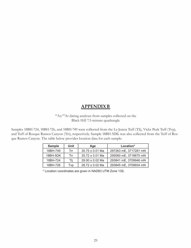
29
APPENDIX B40Ar/39Ar dating analyses from samples collected on the
Black Hill 7.5-minute quadrangle
Samples 18BH-724, 18BH-726, and 18BH-749 were collected from the La Jencia Tuff (Tlj), Vicks Peak Tuff (Tvp), and Tuff of Rocque Ramos Canyon (Trr), respectively. Sample 18BH-5DK was also collected from the Tuff of Roc-que Ramos Canyon. The table below provides location data for each sample:
Sample Unit Age Location*18BH-749 Trr 35.75 ± 0.01 Ma 297263 mE, 3717281 mN18BH-5DK Trr 35.72 ± 0.01 Ma 295060 mE, 3718670 mN18BH-724 Tlj 29.00 ± 0.02 Ma 293841 mE, 3709946 mN18BH-726 Tvp 28.72 ± 0.02 Ma 293845 mE, 3709934 mN
* Location coordinates are given in NAD83 UTM Zone 13S.

30
1
10
100
0
10
20
30
28.2 28.8 29.4 30.0
28.72±0.02MSWD = 2.73n = 13
29.00±0.02 MaMSWD = 11.3n = 12
Age
Rel
ativ
e pr
obab
ility
K/C
a
N
18BH-726AJ 18BH-724AJ

31
Red sample on Priest Tank 7.5-minute quadrangle
28.473 ± 0.011,MSWD = 9.09,n = 17
35.721 ± 0.013,MSWD = 19.49,n = 20
35.750 ± 0.010,MSWD = 4.55,
n = 20
Data at 1-sigma, results at 1-sigma
Age-Probability Spectra for Samples 17PT-193, 18BH-5DK, and 18BH-749AJ
18BH-749AJ
17PT-193
Age (Ma)
Rel
ativ
e pr
obab
ility
N
K/C
a
% R
adio
geni
c
18BH-5DK
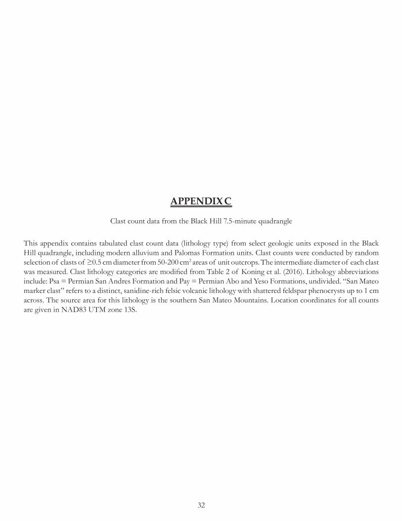
32
APPENDIX C
Clast count data from the Black Hill 7.5-minute quadrangle
This appendix contains tabulated clast count data (lithology type) from select geologic units exposed in the Black Hill quadrangle, including modern alluvium and Palomas Formation units. Clast counts were conducted by random selection of clasts of ≥0.5 cm diameter from 50-200 cm2 areas of unit outcrops. The intermediate diameter of each clast was measured. Clast lithology categories are modified from Table 2 of Koning et al. (2016). Lithology abbreviations include: Psa = Permian San Andres Formation and Pay = Permian Abo and Yeso Formations, undivided. “San Mateo marker clast” refers to a distinct, sanidine-rich felsic volcanic lithology with shattered feldspar phenocrysts up to 1 cm across. The source area for this lithology is the southern San Mateo Mountains. Location coordinates for all counts are given in NAD83 UTM zone 13S.

33
TABLE C.1 CLAST-COUNT DATA FOR UNIT Qam (WAY-POINT 190328_6)
Date 03/28/19 n = 105
UTM Location 3713417N, 295403E
n % total
Total felsic volcanics 38 36%
Crystal-poor felsic volcanics 23 22%
Crystal-rich felsic volcanics 15 14%
Tuffs, undivided 6 6%
“San Mateo” marker clast 6 6%
Vicks Peak Tuff 39 37%
Total intermediate volcanics 1 1%
Crystal-poor intermediate volcanics 0 0%
Crystal-rich intermediate volcanics 1 1%
Feldspar porphyry 0 0%
Paleozoic carbonates 8 8%
Psa + Pay 0 0%
Sandstone+siltstone, undivided 0 0%
Chert and jasperoid 0 0%
Granite 0 0%
Quartzite 0 0%
Vein quartz 0 0%
Basalt 0 0%
Other 7 7%
Comments Crystal-poor felsite is mostly flow-banded rhyo-lite. Other = 3% unknown, 2% breccia, 1% volcani-clastic sandstone, and 1% vitrophyre.
TABLE C.2 CLAST-COUNT DATA FOR UNIT Qppu (WAY-POINT 180912_1-3)
Date 09/12/18 n = 99
UTM Location 3710048N, 297525E
n % total
Total felsic volcanics 30 30%
Crystal-poor felsic volcanics 17 17%
Crystal-rich felsic volcanics 13 13%
Tuffs, undivided 10 10%
“San Mateo” marker clast 22 22%
Vicks Peak Tuff 29 29%
Total intermediate volcanics 1 1%
Crystal-poor intermediate volcanics 0 0%
Crystal-rich intermediate volcanics 1 1%
Feldspar porphyry 3 3%
Paleozoic carbonates 0 0%
Psa + Pay 0 0%
Sandstone+siltstone, undivided 1 1%
Chert and jasperoid 0 0%
Basalt 0 0%
Other 3 3%
Comments Tuffs, undivided includes 2% clasts of La Jencia tuff; Other = 3% unknown.

34
TABLE C.3 CLAST-COUNT DATA FOR UNIT Qppu (WAY-POINT 180912_1-3b)
Date 09/12/18 n = 59
UTM Location 3710649N, 297595E
n % total
Total felsic volcanics 21 21%
Crystal-poor felsic volcanics 10 10%
Crystal-rich felsic volcanics 11 11%
Tuffs, undivided 7 7%
“San Mateo” marker clast 3 3%
Vicks Peak Tuff 25 25%
Total intermediate volcanics 0 0%
Crystal-poor intermediate volcanics 0 0%
Crystal-rich intermediate volcanics 0 0%
Feldspar porphyry 0 0%
Paleozoic carbonates 0 0%
Psa + Pay 0 0%
Sandstone+siltstone, undivided 0 0%
Chert and jasperoid 0 0%
Basalt 0 0%
Other 3 3%
Comments Other = 5% unknown.
TABLE C.4 CLAST-COUNT DATA FOR UNIT Qppu (WAY-POINT 190213_2-3a)
Date 02/13/19 n = 106
UTM Location 3714135N, 301506E
n % total
Total felsic volcanics 0 0%
Crystal-poor felsic volcanics 36 34%
Crystal-rich felsic volcanics 18 17%
Tuffs, undivided 23 22%
“San Mateo” marker clast 3 3%
Vicks Peak Tuff 21 20%
Total intermediate volcanics 0 0%
Crystal-poor intermediate volcanics 0 0%
Crystal-rich intermediate volcanics 1 1%
Feldspar porphyry 0 0%
Paleozoic carbonates 0 0%
Psa + Pay 0 0%
Sandstone+siltstone, undivided 0 0%
Chert and jasperoid 0 0%
Basalt 0 0%
Other 4 4%
Comments Tuffs, undivided includes 3% clasts of La Jencia tuff; other = 1% pumice, 1% breccia, and 2% unknown.

35
TABLE C.5 CLAST-COUNT DATA FOR UNIT QTppm (WAY-POINT 190221_2-1e)
Date 02/21/19 n = 98
UTM Location 3717577N, 302564E
n % total
Total felsic volcanics 38 39%
Crystal-poor felsic volcanics 17 17%
Crystal-rich felsic volcanics 21 21%
Tuffs, undivided 23 23%
“San Mateo” marker clast 6 6%
Vicks Peak Tuff 26 27%
Total intermediate volcanics 2 2%
Crystal-poor intermediate volcanics 1 1%
Crystal-rich intermediate volcanics 1 1%
Feldspar porphyry 0 0%
Paleozoic carbonates 0 0%
Psa + Pay 0 0%
Sandstone+siltstone, undivided 0 0%
Chert and jasperoid 0 0%
Basalt 0 0%
Other 3 3%
Comments Other = 2% unknown, 1% silicic intrusive.
TABLE C.6 CLAST-COUNT DATA FOR UNIT QTpa (WAY-POINT 180913_2-1i)
Date 09/13/18 n = 100
UTM Location 3710438N, 302038E
n % total
Total felsic volcanics 12 12%
Crystal-poor felsic volcanics 8 8%
Crystal-rich felsic volcanics 4 4%
Tuffs, undivided 14 14%
“San Mateo” marker clast 0 0%
Vicks Peak Tuff 4 4%
Total intermediate volcanics 14 14%
Crystal-poor intermediate volcanics 3 3%
Crystal-rich intermediate volcanics 11 11%
Feldspar porphyry 0 0%
Paleozoic carbonates 2 2%
Psa + Pay 2 2%
Sandstone+siltstone, undivided 2 2%
Chert and jasperoid 13 13%
Granite 14 14%
Quartzite 18 18%
Vein quartz 4 4%
Basalt 0 0%
Other 1 1%
Comments Chert and jasperoid includes 4% clasts of Pedernal chert; Other = 1% unknown.

36
TABLE C.7 CLAST-COUNT DATA FOR UNIT Tppl (WAY-POINT 190328_1c)
Date 03/28/19 n = 98
UTM Location 3710696N, 291654E
n % total
Total felsic volcanics 44 45%
Crystal-poor felsic volcanics 30 31%
Crystal-rich felsic volcanics 14 14%
Tuffs, undivided 4 4%
“San Mateo” marker clast 0 0%
Vicks Peak Tuff 39 40%
Total intermediate volcanics 6 6%
Crystal-poor intermediate volcanics 6 6%
Crystal-rich intermediate volcanics 0 0%
Feldspar porphyry 0 0%
Paleozoic carbonates 0 0%
Psa + Pay 0 0%
Sandstone+siltstone, undivided 0 0%
Chert and jasperoid 0 0%
Granite 0 0%
Quartzite 0 0%
Vein quartz 0 0%
Basalt 0 0%
Other 5 5%
Comments Crystal-poor felsite is mostly flow-banded rhyo-lite. Other = 2% intrusive (dioritic?), 2% unknown, and 1% volcaniclastic.

37
APPENDIX D
Maximum clast size data from the Black Hill 7.5-minute quadrangle
Maximum clast size measurements were made of the 10 largest clasts in an area of approximately 75-100 m2. The longest (a) and intermediate (b) axes of each clast were measured. Clast lithologies were noted as well; lithology abbre-viations include: Tvp = Vicks Peak Tuff and Trr = Tuff of Rocque Ramos Canyon. All UTM coordinates are given in NAD83 UTM zone 13S.

38
TABLE D.1 MAXIMUM CLAST SIZE MEASUREMENTS AT WAYPOINT 190212_1-4d
Silver Canyon a axis (cm) b axis (cm) Lithology
Northing 3711886 40.5 25 TvpEasting 302400 58 30.5 Crystal-rich felsiteUnit Qam 32.5 26.5 Undivided tuffMean (a axis) 40 41 25 TvpMedian (a axis) 39 37.5 23 Crystal-rich felsiteMean (b axis) 25 42.5 29 Undivided tuffMedian (b axis) 25 36 22 Crystal-rich felsiten 10 35.5 22 Tvp
42 25.5 Undivided tuff32 21 Crystal-poor felsite
TABLE D.2 MAXIMUM CLAST SIZE MEASUREMENTS AT WAYPOINT 190328_6
Nogal Canyon a axis (cm) b axis (cm) Lithology
Northing 3713417 49.5 46 TvpEasting 295403 49.5 25.5 Crystal-rich felsiteUnit Qam 46 19 Crystal-rich felsiteMean (a axis) 44 51 35.5 Crystal-rich felsiteMedian (a axis) 45 53 29.5 TvpMean (b axis) 31 42 37 Undivided tuffMedian (b axis) 29.5 38 29.5 Tvpn 10 33.5 31 Vitrophyre
34 27.5 Crystal-rich felsite43.5 29.5 Crystal-rich felsite
TABLE D.3 MAXIMUM CLAST SIZE MEASUREMENTS AT WAYPOINT 180912_1-3
a axis (cm) b axis (cm) Lithology
Northing 3710048 33.5 22 TvpEasting 297525 26 15.5 Crystal-poor felsiteUnit Qppu 29 23 Crystal-rich felsiteMean (a axis) 27 26 18 TvpMedian (a axis) 26 26.5 19 TvpMean (b axis) 17 20 20 TvpMedian (b axis) 16.75 25.5 14.5 Tvpn 10 25 15 Crystal-poor felsite
24.5 11 Tvp33 15 Undivided tuff

39
TABLE D.4 MAXIMUM CLAST SIZE MEASUREMENTS AT WAYPOINT 190212-2
a axis (cm) b axis (cm) Lithology
Northing 3715689 23 18 Crystal-poor felsiteEasting 300537 23.5 19.5 TvpUnit Qppu 25.5 12.5 Crystal-poor felsiteMean (a axis) 22 24 14.5 Crystal-poor felsiteMedian (a axis) 21 18.5 11 Crystal-poor felsiteMean (b axis) 14 20.5 13 Crystal-poor felsiteMedian (b axis) 13 20 9 Crystal-rich felsiten 10 19 13 Feldspar porphyry
19.5 14.5 Crystal-poor felsite21.5 12 Crystal-rich felsite
TABLE D.5 MAXIMUM CLAST SIZE MEASUREMENTS AT WAYPOINT 190212-2
a axis (cm) b axis (cm) Lithology
Northing 3712466 26.5 9 Crystal-rich felsiteEasting 301418 15 13.5 Crystal-rich felsiteUnit Qppu 26 14 Undivided tuffMean (a axis) 19 14 12 Undivided tuffMedian (a axis) 17 15 12 Undivided tuffMean (b axis) 12 17 11 Crystal-poor felsiteMedian (b axis) 12 17.5 13.5 Crystal-poor felsiten 10 15.5 11.5 Crystal-rich felsite
16 14 Tvp22.5 11.5 Tvp
TABLE D.6 MAXIMUM CLAST SIZE MEASUREMENTS AT WAYPOINT 190221_2-1e
a axis (cm) b axis (cm) Lithology
Northing 3717577 12 5.5 Crystal-poor felsiteEasting 302564 12 7 TvpUnit QTppm 11 7 TvpMean (a axis) 11 10 6 Trr?Median (a axis) 11 9.5 6.5 Crystal-rich felsiteMean (b axis) 7 10 6.5 TvpMedian (b axis) 7 8.5 8 Tvpn 10 13.5 8 Crystal-rich felsite
10.5 7 Crystal-rich felsite11 7.5 Crystal-poor felsite

40
TABLE D.7 MAXIMUM CLAST SIZE MEASUREMENTS AT WAYPOINT 190328_1c
a axis (cm) b axis (cm) Lithology
Northing 3710696 45 44.5 TvpEasting 291654 61 50.5 TvpUnit Tppl 62.5 36 Crystal-rich felsiteMean (a axis) 60 53 35 Crystal-rich felsiteMedian (a axis) 60 54 37 Crystal-rich felsiteMean (b axis) 40 65.5 48 Crystal-rich felsiteMedian (b axis) 40.5 73 44 Tvpn 10 58.5 36 Crystal-rich felsite
58 26.5 Tvp66 44.5 Crystal-poor felsite

41
APPENDIX E
Paleocurrent data from the Black Hill 7.5-minute quadrangle
This appendix contains tabulated paleocurrent direction data (azimuthal) measured from imbrication of gravels and channel axes and margins from Palomas Formation units exposed in the Black Hill quadrangle. A Brunton pocket transit was used for all measurements. Location coordinates for all measurements are given in NAD83 UTM zone 13S. Mean paleocurrent directions are shown on the geologic map.

42
TABLE E.1 IMBRICATION PALEOCURRENT MEASUREMENTS AT WAYPOINT 180516_3Flow direction measurements
Northing 3712451 120 120 139 128 137 145Easting 296015 120 120 131 128 133 127Unit Qppu 120 139 131 166 133 127Mean 132 120 139 131 166 135 127Median 134 120 139 149 135 135 134n 57 120 139 149 135 135 139
120 139 100 135 145 139120 139 100 125 145120 139 128 125 145120 139 128 137 145
TABLE E.2 IMBRICATION PALEOCURRENT MEASUREMENTS AT WAYPOINT 180912_1-1bFlow direction measurements
Northing 3709190 146 154 191 181Easting 298433 146 160 156 181Unit Qppu 163 160 156 155Mean 168 163 160 194 155Median 163 163 160 194 141n 35 163 160 175
163 191 175154 191 175154 191 175154 191 181
TABLE E.3 IMBRICATION PALEOCURRENT MEASUREMENTS AT WAYPOINT 180912_1-2eFlow direction measurements
Northing 3709851 92 150 112 92 107Easting 299100 92 150 112 92 161Unit Qppu 66 96 112 96 161Mean 108 66 96 112 96Median 96 66 96 112 115n 43 66 96 92 115
150 96 92 115150 96 92 107150 96 92 107150 112 92 107

43
TABLE E.4 IMBRICATION PALEOCURRENT MEASUREMENTS AT WAYPOINT 180912_1-3Flow direction measurements
Northing 3710048 93 89 170 145 148 104Easting 297525 93 89 170 145 88 104Unit Qppu 93 142 154 121 88 141Mean 130 167 142 154 98 100 141Median 141 167 161 154 98 100 141n 56 167 129 154 109 100 141
160 129 154 109 147160 129 145 109 14789 170 145 109 14789 170 145 148 104
TABLE E.5 IMBRICATION PALEOCURRENT MEASUREMENTS AT WAYPOINT 180912A_1-3eFlow direction measurements
Northing 3710975 153 120 80Easting 297141 153 120 80Unit Qppu 153 120 100Mean 114 153 120 100Median 110 153 110 100n 29 153 110 81
153 80 81125 80 109125 80 109125 80
TABLE E.6 IMBRICATION PALEOCURRENT MEASUREMENTS AT WAYPOINT 180912B_1-3eFlow direction measurements
Northing 3710975 160 157 88Easting 297141 160 157 119Unit Qppu 160 157 119Mean 125 121 91 79Median 125 121 91 79n 27 125 138 79
125 138 79157 138157 138157 88

44
TABLE E.7 IMBRICATION PALEOCURRENT MEASUREMENTS AT WAYPOINT 181108_2eFlow direction measurements
Northing 3711866 69 96 123 95Easting 300974 69 125 96 97Unit Qppu 69 125 96 97Mean 89 69 87 91Median 91 69 87 91n 33 54 87 91
54 85 10556 85 95104 85 9596 85 95
TABLE E.8 IMBRICATION PALEOCURRENT MEASUREMENTS AT WAYPOINT 181108_3bFlow direction measurements
Northing 3712340 123 133 107 102Easting 300636 123 133 152 102Unit Qppu 123 133 152 102Mean 124 133 133 119 102Median 130 133 122 119 102n 37 133 122 128 99
133 122 128 99133 135 130133 135 130133 135 130
TABLE E.9 IMBRICATION PALEOCURRENT MEASUREMENTS AT WAYPOINT 190212_1-3cFlow direction measurements
Northing 3713021 140 165 110 161Easting 300655 140 165 180 154Unit Qppu 140 107 180 154Mean 137 144 107 112 154Median 140 144 155 112 154n 35 120 126 112
114 126 112165 126 110165 126 110165 90 161

45
TABLE E.10 IMBRICATION PALEOCURRENT MEASUREMENTS AT WAYPOINT 190212_1-3hFlow direction measurements
Northing 3713096 176 174 131 165Easting 301205 147 113 131 158Unit Qppu 147 113 131 158Mean 152 147 150 131 166Median 156 147 150 107 167n 37 174 150 107 167
174 156 170 167174 156 170174 159 140174 159 140
TABLE E.11 IMBRICATION PALEOCURRENT MEASUREMENTS AT WAYPOINT 190213_2-2bFlow direction measurements
Northing 3714169 106 93 78 89 86 135Easting 302180 106 93 78 91 86Unit Qppu 144 95 78 139 86Mean 115 144 95 129 139 158Median 115 144 137 129 139 158n 51 145 137 115 139 104
145 137 115 105 104145 137 115 105 13593 78 115 105 13593 78 89 105 135
TABLE E.12 IMBRICATION PALEOCURRENT MEASUREMENTS AT WAYPOINT 190213_2-4aFlow direction measurements
Northing 3714820 146 147 194 141 177Easting 301855 146 147 194 141 177Unit Qppu 146 184 194 141 171Mean 162 146 184 158 141 171Median 158 146 184 158 139 165n 50 143 170 197 139 165
143 146 197 139 165143 146 197 177 165143 146 172 177 146143 194 172 177 146

46
TABLE E.13 IMBRICATION PALEOCURRENT MEASUREMENTS AT WAYPOINT 190213_2-6aFlow direction measurements
Northing 3715138 140 93 89 100 157Easting 302401 140 93 89 100 157Unit Qppu 140 111 105 152 125Mean 113 105 111 105 152 125Median 105 105 111 105 95 114n 45 105 111 125 95
141 105 125 9593 105 125 9993 105 100 9993 105 100 157
TABLE E.14 IMBRICATION PALEOCURRENT MEASUREMENTS AT WAYPOINT 190214_3-1aFlow direction measurements
Northing 3712724 111 152 160 113 160 166Easting 297706 111 152 160 113 160 166Unit Qppu 111 152 149 106 160 166Mean 131 111 152 149 106 85 108Median 115 111 152 115 106 85 108n 57 111 114 115 106 85 108
146 114 115 106 85 108146 114 115 179 161146 114 115 179 161146 160 113 160 161
TABLE E.15 IMBRICATION PALEOCURRENT MEASUREMENTS AT WAYPOINT 190214_3-1cFlow direction measurements
Northing 3712376 50 114 104 102 132 96Easting 298069 50 114 104 70 132 96Unit Qppu 50 114 104 70 132Mean 100 92 114 80 112 115Median 100 92 101 80 112 115n 52 92 101 94 112 115
83 101 94 112 14283 98 94 130 14283 98 94 100 9683 98 102 100 96

47
TABLE E.16 IMBRICATION PALEOCURRENT MEASUREMENTS AT WAYPOINT 190214_3-2Flow direction measurements
Northing 3712495 139 150 130 159 150Easting 297391 139 190 166 159 88Unit Qppu 139 190 125 100 88Mean 131 139 190 125 100 88Median 125 105 190 125 100 88n 50 105 118 125 100 88
105 118 125 100 120105 118 139 100 120150 184 139 195 120150 130 139 150 120
TABLE E.17 IMBRICATION PALEOCURRENT MEASUREMENTS AT WAYPOINT 190220_1-1dFlow direction measurements
Northing 3716723 140 120 187Easting 302488 140 120 187Unit Qppu 140 120 196Mean 144 140 159 196Median 140 140 159 95n 30 140 159 137
95 159 18095 159 130120 159 130120 159 130
TABLE E.18 IMBRICATION PALEOCURRENT MEASUREMENTS AT WAYPOINT 190220_1-2cFlow direction measurements
Northing 3716077 180 157Easting 302214 180 157Unit Qppu 180 157Mean 165 180 168Median 168 143 168n 18 143 168
174 168174 168150150

48
TABLE E.19 IMBRICATION PALEOCURRENT MEASUREMENTS AT WAYPOINT 190220_1-2eFlow direction measurements
Northing 3716180 160 127 130 143 100Easting 301507 160 127 130 143 100Unit Qppu 160 127 130 143 100Mean 133 160 148 130 130 101Median 130 160 148 161 130 101n 49 160 166 161 130 115
160 166 161 122 115160 115 161 122 11574 115 161 100 11574 115 161 100
TABLE E.20 IMBRICATION PALEOCURRENT MEASUREMENTS AT WAYPOINT 190319_1aFlow direction measurements
Northing 3714928 69 80 92 135 74 61 144Easting 300673 69 80 92 135 74 61 96Unit Qppu 69 80 92 135 70 96 96Mean 83 69 80 95 59 70 96Median 74 116 60 95 59 70 73n 63 116 60 95 58 49 73
104 60 50 58 49 73104 60 50 58 49 14480 60 50 74 129 14480 92 50 74 129 144
TABLE E.21 CHANNEL MARGIN PALEOCURRENT MEASUREMENTS AT WAYPOINT 190319_1iFlow direction measurements
Northing 3715689 133Easting 300537 124Unit Qppu 113Mean 123Median 124n 3

49
TABLE E.22 IMBRICATION PALEOCURRENT MEASUREMENTS AT WAYPOINT 190319_2aFlow direction measurements
Northing 3716629 89 135 71 30 42 81 56Easting 300220 89 135 71 30 42 60 56Unit Qppu 89 56 71 30 42 60 56Mean 78 89 56 74 30 42 100 96Median 74 89 56 74 30 42 100 96n 66 89 56 74 96 42 100 96
89 56 144 96 54 9189 56 144 96 54 9189 60 144 141 54 9189 60 144 141 81 56
TABLE E.23 IMBRICATION PALEOCURRENT MEASUREMENTS AT WAYPOINT 190319_2fFlow direction measurements
Northing 3717588 145 155 79 116 69Easting 300838 145 120 79 116 165Unit Qppu 145 120 134 129 165Mean 118 107 120 134 129 114Median 120 107 120 134 83 114n 46 107 128 115 83 114
107 128 115 83107 128 147 69139 140 147 69155 140 116 69
TABLE E.24 IMBRICATION PALEOCURRENT MEASUREMENTS AT WAYPOINT 190328_1dFlow direction measurements
Northing 3710237 60 114 78Easting 293464 60 123 78Unit Qppu 60 123 97Mean 88 60 123 97Median 96 60 123 97n 28 60 63 97
95 63 97114 63 97114 63114 78
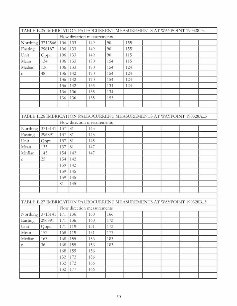
50
TABLE E.25 IMBRICATION PALEOCURRENT MEASUREMENTS AT WAYPOINT 190328_3aFlow direction measurements
Northing 3712566 106 133 149 90 155Easting 296187 106 133 149 90 155Unit Qppu 106 133 149 90 115Mean 134 106 133 170 154 115Median 136 106 133 170 154 124n 48 136 142 170 154 124
136 142 170 154 124136 142 135 134 124136 136 135 134136 136 135 155
TABLE E.26 IMBRICATION PALEOCURRENT MEASUREMENTS AT WAYPOINT 190328A_5Flow direction measurements
Northing 3713141 137 81 145Easting 296891 137 81 145Unit Qppu 137 81 145Mean 133 137 81 147Median 145 154 142 147n 25 154 142
159 142159 145159 14581 145
TABLE E.27 IMBRICATION PALEOCURRENT MEASUREMENTS AT WAYPOINT 190328B_5Flow direction measurements
Northing 3713141 171 136 160 166Easting 296891 171 136 160 173Unit Qppu 171 119 131 173Mean 157 168 119 131 173Median 163 168 155 156 183n 36 168 155 156 183
168 155 156132 172 156132 172 166132 177 166
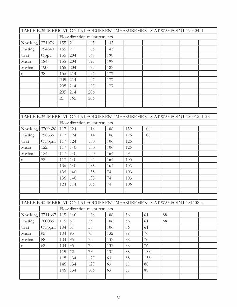
51
TABLE E.28 IMBRICATION PALEOCURRENT MEASUREMENTS AT WAYPOINT 190404_1Flow direction measurements
Northing 3710761 155 21 165 145Easting 294340 155 21 165 145Unit Qppu 155 204 165 198Mean 184 155 204 197 198Median 190 166 204 197 182n 38 166 214 197 177
205 214 197 177205 214 197 177205 214 20621 165 206
TABLE E.29 IMBRICATION PALEOCURRENT MEASUREMENTS AT WAYPOINT 180912_1-2bFlow direction measurements
Northing 3709626 117 124 114 106 159 106Easting 298866 117 124 114 106 125 106Unit QTppm 117 124 150 106 125Mean 122 117 140 150 106 125Median 124 117 140 150 164 59n 52 117 140 135 164 103
136 140 135 164 103136 140 135 74 103136 140 135 74 103124 114 106 74 106
TABLE E.30 IMBRICATION PALEOCURRENT MEASUREMENTS AT WAYPOINT 181108_2Flow direction measurements
Northing 3711667 115 146 134 106 56 61 88Easting 300085 115 51 55 106 56 61 88Unit QTppm 104 51 55 106 56 61Mean 95 104 93 73 132 88 76Median 88 104 95 73 132 88 76n 62 104 95 73 132 88 76
115 72 73 132 88 138115 134 127 63 88 138146 134 127 63 61 88146 134 106 63 61 88

52
TABLE E.31 IMBRICATION PALEOCURRENT MEASUREMENTS AT WAYPOINT 180913_2-1hFlow direction measurements
Northing 3710427 155 157 169 151 168 168Easting 302021 155 165 169 170 131 168Unit QTpa 152 165 169 170 131Mean 164 152 165 169 170 176Median 168 152 165 169 170 176n 52 152 165 169 170 217
147 191 157 168 168157 191 157 168 168157 191 108 168 168157 191 151 168 168
TABLE E.32 CHANNEL AXES PALEOCURRENT MEASUREMENTS AT WAYPOINT 180913_2-2cFlow direction measurements
Northing 3709849 159Easting 302149 205Unit QTpa 224Mean 196Median 205n 3
TABLE E.33 IMBRICATION PALEOCURRENT MEASUREMENTS AT WAYPOINT 190328_1bFlow direction measurements
Northing 3710674 122 189 124 104 118Easting 291626 122 189 124 104Unit Tppl 122 189 124 104Mean 120 122 153 95 104Median 122 122 153 95 125n 41 122 109 95 125
122 109 56 125122 109 56 114144 109 104 114144 109 104 118