Embed Size (px)
Citation preview

Geographic Principles Geographic Principles and Mappingand Mapping

Geography studies anything related to place, turning…Space into PlacePlace
• AbstractAbstract• GeometricGeometric• EmptyEmpty• ““Just there”Just there”
• RealReal• Has IdentityHas Identity• SignificantSignificant• ““It matters”It matters”

SITE (physical attributes of place)
+
SITUATION (relationship / relative location to other places)
+
SENSE OF PLACE (feelings and thoughts evoked by place)
=
PLACE(geographic setting with distinctive
physical, social, and cultural attributes: “Identity”):It’s “where stuff happens”

UW-Eau Claire as a placeUW-Eau Claire as a place
• SITE: students, faculty, buildings, “The Hill,” dorms, etc.SITE: students, faculty, buildings, “The Hill,” dorms, etc.
• SITUATION: near downtown , along Chippewa River, 90 SITUATION: near downtown , along Chippewa River, 90 miles north of LaCrosse, in Eau Claire county, 715 area miles north of LaCrosse, in Eau Claire county, 715 area code and…? code and…?
• SENSE OF PLACE: free to live on your own, the SENSE OF PLACE: free to live on your own, the Viennese Ball, place of great diversity, floating down the Viennese Ball, place of great diversity, floating down the river, the great mystery of what’s a “Blugold?”river, the great mystery of what’s a “Blugold?”
534534

And by categorizing a bunch of places, we create….
Regions!Regions!
……but What is a Region?but What is a Region?

Regions come in an endless
variety of shapes, sizes, and types


Moral of Moral of the Story:the Story:Regions are:Regions are:
……in the eye in the eye of the of the
beholder.beholder.

Mapping these RegionsMapping these Regions

Maps.Maps.
Why do we care about maps?

MAPSMAPS == LIFELIFE

Not only do maps = life.““Maps” spelled backward is…Maps” spelled backward is…

MapsMaps• Elements of a Map
• The Geographic Grid: o Latitudeo Longitude
• Map Projections
• Scale
• Types of Maps
• GIS (Geographic Information Systems)
• Mental Maps

Elements Elements of a mapof a map
• POINTS POINTS – cities, sites, etc.
• LINESLINES– boundaries, routes, etc.
• FILLSFILLS– political colors, thematic patterns, etc.
• TYPE / SYMBOLSTYPE / SYMBOLS– Labels, statistical charts, etc.
Map of the EuroMap of the Euro
€€

BangkokBangkok
Type and SymbolsType and Symbols
Luxembourg MetroLuxembourg Metro

The Geographic GridThe Geographic Grid
Latitude lines(parallels)
run East-West, measure N or S
(90˚ N)
Longitude lines(meridians)
run North-South, measure E or W.
Santiago, Chile33˚ 28’ 46” S 70˚ 39’ 41” W
InternationalDate Line
180˚
Degrees ˚Minutes ’Seconds ”
““GMT”GMT”Lagos, Nigeria6˚ 26’ 56” N 3˚ 23’ 31” E
South Pole (90˚ S)

Prime Prime MeridianMeridian
00° E / W° E / W
LondonLondon••(Greenwich)(Greenwich)

You can actually stand on it!You can actually stand on it!

A great day for geography…A great day for geography…

Even right here in Wisconsin…Even right here in Wisconsin…
••Eau ClaireEau Claire
45N

Poniatowski,Wisconsin
45˚ 00’ 00” N 90˚ 00’ 00” W
Wrong!Wrong!

““Geological” Geological” MarkerMarker
True True 45˚ 90˚ 45˚ 90˚
SiteSite

Using Your AtlasUsing Your Atlas

World MapsWorld Maps(pp. 1-84)(pp. 1-84)
CLIMATE

World Religions

Languages of the WorldLanguages of the World
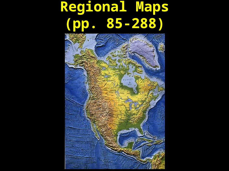
Regional MapsRegional Maps(pp. 85-288)(pp. 85-288)


Other InformationOther Information(pp. 289 - 400)(pp. 289 - 400)
• Pages 289 – 293: Pages 289 – 293: Political Information TablePolitical Information Table– Country, Area, Pop, Type of Government, Capital, etc.Country, Area, Pop, Type of Government, Capital, etc.
• Page 294: Page 294: World ComparisonsWorld Comparisons– Areas, lengths, heightsAreas, lengths, heights– Continents, Islands, Oceans, Mountains, Rivers, etc.Continents, Islands, Oceans, Mountains, Rivers, etc.
• Page 295: Page 295: Major World City PopulationsMajor World City Populations• Page 296: Page 296: Foreign Geographical TermsForeign Geographical Terms
– ““fjord,” “rio,” “eau”fjord,” “rio,” “eau”• Page 297: Page 297: Abbreviations and Pronunciation GuideAbbreviations and Pronunciation Guide• Page 300: Page 300: Subject IndexSubject Index

Index!Index!(pp. 301-400)(pp. 301-400)
• Can’t find a place? Use the index!Can’t find a place? Use the index!– Name of a place / feature:Name of a place / feature:
• country, city, ocean, desert, river, etc.country, city, ocean, desert, river, etc.
– Page NumberPage Number
– Latitude and LongitudeLatitude and Longitude
• OK, Let’s find… OK, Let’s find…

OuagadougouOuagadougou..

Sample Questions:Sample Questions:1.1. What is the latitude and longitude What is the latitude and longitude
of the capital of Paraguay?of the capital of Paraguay?2.2. What is biggest city in the country What is biggest city in the country
that exports the most bananas?that exports the most bananas?3.3. What is the population of the What is the population of the
metropolitan area around the metropolitan area around the capital of the country on the capital of the country on the southern border of Mt. Lenin?southern border of Mt. Lenin?
Exercise 1: Using Your AtlasExercise 1: Using Your Atlas

Projections: Turning a globe into a map Projections: Turning a globe into a map

Map Projections Map Projections ALL Map Projections Distort…
• Distance, orDistance, or• Direction, orDirection, or• Shape, orShape, or• A combination of the above.A combination of the above.

Map Projections of a Human
Head

Mercator ProjectionMercator Projection • One of the first One of the first
projections projections
• Parallel lines Parallel lines (better for (better for navigation)navigation)
• Distortion toward Distortion toward poles poles (Greenland), (Greenland), therefore therefore Northern Northern hemisphere hemisphere appears “larger”appears “larger”
• (Eurocentric?)(Eurocentric?)

Goode’s Homolosine Projection Goode’s Homolosine Projection
• Non-Contiguous Non-Contiguous • Equal Area ProjectionEqual Area Projection• Shows true areaShows true area• Less distortionLess distortion• Harder to navigate withHarder to navigate with

• Combination of Mercator and Goode’s Homolosine projections• Also equal area• 1974 (new)• Political Controversy• Focuses on “South” Peters ProjectionPeters Projection

Robinson ProjectionRobinson Projection
• Good between 45°N and 45°S• Focuses on equator• Does not show equal area• Poles appear as “lines;” not points• Good “visual” (not navigational) representation

ScaleScale

Definition #1: Definition #1: • The size/scope of
places being studied
• Local issues versus regional, national, or global issues
Scale Scale
Definition #2: • Indicates the ratio of distance
and area on Earth to the distance and area on a map
• Examples:– 1 cm on map equals 1 km– 1 inch equals 1 mile– 1 mile equals 1 mile (?)
• Representations:– proportional fraction (1/100,000)– ratio (1:100,000)– bar scale– verbal statement

BAR SCALEBAR SCALERATIORATIO

““Opposite” meaning of scaleOpposite” meaning of scale
• A scale of 1/5,000 is a large-scale map compared to a scale of 1/1,000,000.
• Fractions: 1/5,000 > 1/1,000,000
Large-scale map:Large-scale map:•Shows a small area Shows a small area •Much detailMuch detail Small-scale map:
•Shows a large area•Less detail

Types of Maps• Choroplethic
– Uses choropleths, or existing (political) units– State map, county map, country map, etc.
• Isometric– Uses isolines, or data lines (such as contours)– Climate, elevation, diffusion
• Symbolic– Proportional representation– “pie” charts, bar graphs, etc.
• Cartograms– Visual proportionality
• Or any combination of the above

Choroplethic Map: Choroplethic Map: Access to Clean Water

Isometric map:Isometric map: Climate and Weather

Topographic map:Topographic map:(using elevation contour isolines)(using elevation contour isolines)
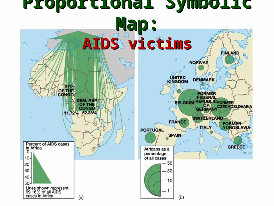
Proportional Symbolic Map:Proportional Symbolic Map:AIDS victimsAIDS victims

Symbolic MapSymbolic MapRestaurants, Restaurants,
Gas Gas Stations, Stations,
and Stores and Stores in an area of in an area of
Fort Fort LauderdaleLauderdale
N̂ �

Cartogram:Cartogram:Population growth rates Population growth rates

Geographic Information
Systems (GIS)
• Data-driven digital systems
• Allows merging (comparison) of data using layers of information on a map.
• Fastest growing area of geographic jobs
• Highly technical, centered in government and business

Mental Maps (cognitive maps):OUR geographical perceptions!

New New Yorker’s Yorker’s View ofView of
the the WorldWorld

The World as seen from UkraineThe World as seen from Ukraine

Mental Map Interpretation
• Selection of information, details, labelsSelection of information, details, labels
• Omission is as important as inclusionOmission is as important as inclusion
• Proportions of sizes, scales, shapesProportions of sizes, scales, shapes
• Choice of physical or cultural featuresChoice of physical or cultural features
• Relative placement of featuresRelative placement of features
• Influence of personal experienceInfluence of personal experience
• Influence of media and world eventsInfluence of media and world events