Embed Size (px)
Citation preview

29.5.2012
1
Geodetic Measurements for Detecting Movements on the Structure Surface
Due to Mining Activities
Eray CAN, Senol KUSCU, Cetin Mekik
Presenter: Eray CAN
Bulent Ecevit University
Department of Geodesy and PhotogrammetryEngineering
Zonguldak,TURKEY
FIG Working Week 2012Rome, Italy, 6-10 May 2012
Mining activities cause to create gaps inside the ground.
INTRODUCTION
The gaps withstand the load over it by vaulting inside theground and prevent caving-in as long as they areopened deeper into ground and remain in smallerproportions as is the case in mining galleries dependingupon the production length.
With the mining production gaps reaching largerdimensions, however, the ground just above the gapsstarts to collapse by layers breaking away and fills upthe production gaps.

29.5.2012
2
Figure 1. Layer movements caused by a mine pit working with thecaving method and their effects on ground surface (Kuscu, 1986,Canet al 2011).
The movements of ground on the surface triggered bythe collapse of cascading internal ground layers aretermed as mining subsidence (Kratzsch, 1983;Kuşçu,1991; Perski and Jura, 2003; Deck et al., 2003;Duzgun, 2005; Akçın et al,. 2006; Saeidi et al., 2009;Can et al., 2011a, 2011b).
These movements cause deformations on the earthsurface and in the affected ground layers anddisruptions on the natural balance of ground. As aconsequence of this, engineering structures inside theaffected ground and on the earth surface above thesubsidence region either accommodate to thesedeformations or sustain damages

29.5.2012
3
These damages whether they occur on natural orman-made structures by means of mining subsidenceare called mining damages.
In Zonguldak Kozlu Hard Coal Region, coal seams dipmostly at high angle and their thicknesses are notuniform, therefore mining subsidence problems are mostlikely to occur causing very serious problems with regardto urbanization.
2. MONITORING OF MINING SUBSIDENCE
It is necessary to gather information on general andregional properties of subsidence formation and effectiveconstituents which eventually cause damages onstructures in order to mitigate mining subsidenceinduced issues and to provide solutions.
Therefore it is of great importance that subsidencemeasurements and observation should be conducted onthe earth surface and, if necessary, in the underground.

29.5.2012
4
Even though the mining activities have been going onfor 160 years in Zonguldak Hard Coal Basin there existslittle or no knowledge on this, which is needed dearlytoday especially with the densification of settlementareas just above the old coal production galleries andmining activities continuing under new settlement areas.
The coal seams in Kozlu production region have steepinclinations as is generally the case in Zonguldak HardCoal Basin and the subsidence occurring in this regionhave adverse effects on social, economic and legalaspects of life (Turer, 2008).
Figure 2. Subsidence tub forming after production in inclined coal seams and the other related definitions (Kratzsch, 1983).
Fig 2 depicts the subsidence formation and its influenceareas after mining activities in inclined coal seams in theregion.

29.5.2012
5
Fig 3 depicts 3D image of the coal seams in the north-south direction (Courtesy of THCE)(Can et al 2011)
Figure 3D image of the coal seams (Courtesy ofTHCE)
In order to determine the subsidence occurring due tomining activities in an underground mine productionregion, subsidence measurements are utilized toascertain:
•Subsidence parameters (critical and limit angles,displacement values etc.),•Relationship between subsidence and geology,tectonics and topography,•Relationship between subsidence and productionspeed and time,•Relationship between subsidence and productionmethod,

29.5.2012
6
3. FEATURES OF KOZLU COAL PRODUCTIONREGION
Kozlu-Zonguldak Hard Coal Basin is a formation ofthe Late Plaeozoic–Mesozoic Age, consisting ofvarious faults and topographic irregularities along theNorth Anatolian Mountain Range.
The town of Kozlu within the Zonguldak Hard CoalBasin was established in 1941 and has a coalproduction rate of 780,000 ton per year along with3.3 million ton per year in the whole basin (URL12011; URL 2 2011).
Kozlu is located in the Western Black Sea Region of Turkey at latitudes 41°–27′ N and longitudes 31°–49′ E (Citiroglu and Baysal, 2011). (Figure 4)
Figure 4 Kozlu Town
29.5.2012
7
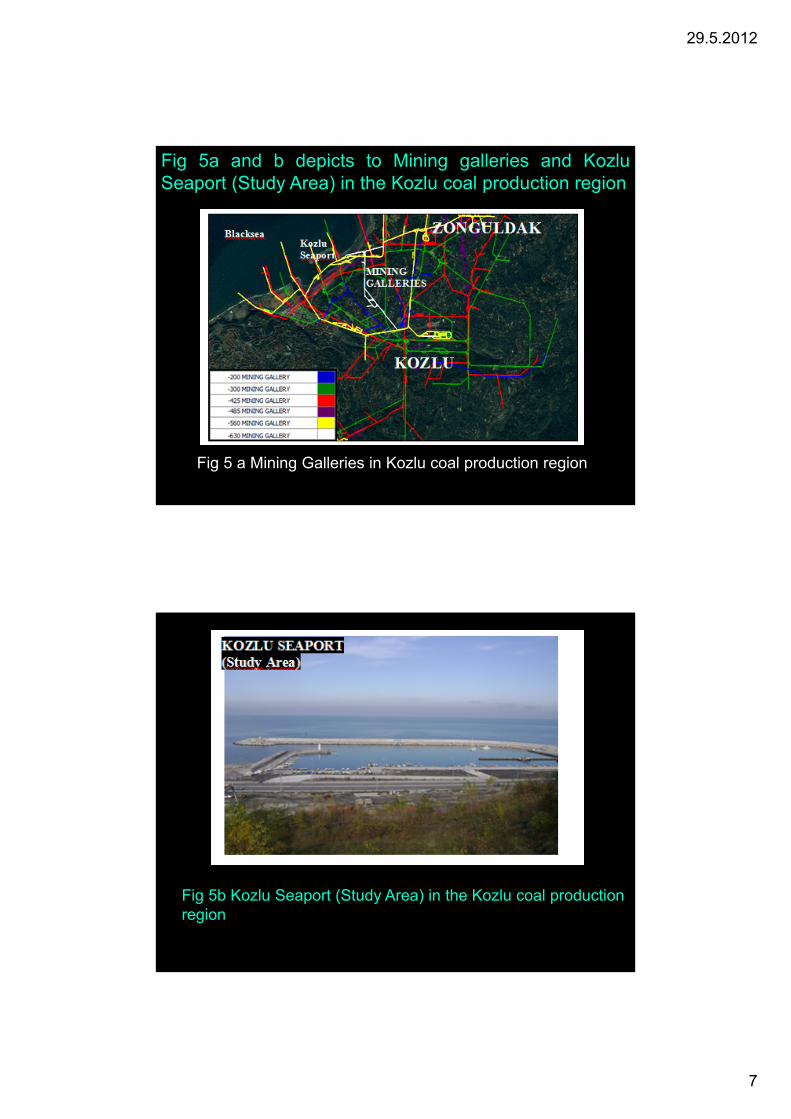
.
Fig 5a and b depicts to Mining galleries and KozluSeaport (Study Area) in the Kozlu coal production region
Fig 5 a Mining Galleries in Kozlu coal production region
Fig 5b Kozlu Seaport (Study Area) in the Kozlu coal production region

29.5.2012
8
4. GEOMETRICAL PROPERTIES OF MININGPANELS AFFECTING KOZLU SEAPORT
The coal seams under the engineering structuresfocused on in this study have steep inclinationangles, and they house production panels working onlongwall method. Figures 6 demonstrate Ikonossatellite images containing old and new productionpanels just under Kozlu Seaport with active andresidual subsidence effects.
Figure 6 Influence areas of old and new production panels inKozlu Seaport under active and residual subsidence influences.

29.5.2012
9
Table 1a. Geometrical properties of production panelsunder Kozlu Seaport (computed in accordance with the National Coal
Board (NCB))
Panel name Year Inclination Thickness Width Hmean
E.U.2 (old) 1988 40o 3m 60m -456m
E.U.3 (old) 1990 40o 3m 60m -434m
E.U.4 (old) 2004 58o 3m 50m -510m
E.U.5 (old) 2006 32o 2m 110m -508m
E.U.6 (old) 1989 26o 1.5m 190m -400m
E.U. 10 (old) 1987 28o 3m 120m -283m
E.U.12 (old) 1990 27o 3m 80m -256m
E.U.13 (old) 1990 17o 3m 60m -321m
Y.U.2 (new) 2009 29o 2.5m 130m -510m
Y.U.3 (new) 2009 20o 2m 30m -445m
Y.U.4(new) 2009 44o 2m 20m -450m
Y.U: New mining panels E.U: Old mining panels
Table 1b. The maximum possible subsidencemagnitudes and parameters computed in accordancewith the NCB in Kozlu Seaport region.
Panel name Smax(vertical)
Subsidence type
γlower γmedium γupper
E.U.2 (old) 0.4cm Residual 28o 55o 85o
E.U.3 (old) 0.2cm Residual 28o 55o 85o
E.U.4 (old) 1.1cm Residual 29o 55o 84o
E.U.5 (old) 1.3cm Residual 29o 55o 83o
E.U.6 (old) 9.5cm Residual 32o 55o 81o
E.U. 10 (old) 1.9cm Residual 30o 55o 83o
E.U.12 (old) 5.9cm Residual 30o 55o 82o
E.U.13 (old) 0.6cm Residual 38o 55o 75o
Y.U.2 (new) 3cm Active 30o 55o 82o
Y.U.3 (new) 1cm Active 37o 55o 76o
Y.U.4(new) 0.3cm Active 27o 55o 85o

29.5.2012
10
Table 3a lists the computed semi-major and –minoraxes values of an ellipse enveloping possiblesubsidence affected areas of old and new productionpanels in Kozlu Seaport under residual and activesubsidence effects for plotting purposes
5. PRECISE LEVELING AND GPS MEASUREMENTSIN KOZLU SEAPORT
In order to determine subsidence magnitudes in theaforementioned region just under the engineeringstructures three periods of precise leveling and GPSmeasurements were conducted in August 2009, May2010 and November 2010.
The one hour static GPS data were collected at thesubsidence monitoring points with an observation epochof 2009.58 in the first period, 2010.40 in the secondperiod and 2010.90 in the third period.
Table 4 a,b,c lists horizontal displacement vectors ofsubsidence monitoring points T34, T35, T36, T37, T38,T39 and T40 in Kozlu Seaport.

29.5.2012
11
Table 4a
Table 4b
Table 4c
Figures 4 depict Ikonos satellite images containinghorizontal displacement vectors obtained using thethree periods of GPS measurements on the subsidencemonitoring points in Kozlu Seaport.

29.5.2012
12
It is hard to imply that horizontal and verticaldisplacements have caused any visual deformationsor functional defects in the seaport during the threeperiods of GPS and precise leveling measurementsin the region.
As for the vertical displacements Tables 5 list thefindings obtained from the three period pairs ofprecise leveling measurements for Kozlu Seaport
Table 5. Vertical displacement vectors of subsidencemonitoring points in Kozlu Seaport with their RMSE values forthe period pairs

29.5.2012
13
Figures 5 depicts Ikonos satellite images containingvertical displacement vectors obtained using the threeperiods of precise leveling measurements on thesubsidence monitoring points in Kozlu Seaport
6.CONCLUSIONS
Kozlu mining production region with extensive miningactivities houses, many crucial engineering structuressuch as Kozlu Seaport which are the core of this studyand there are plans for new constructions on evendaily basis in the region.
In order to maintain the mining operations along withurban developments in a healthy way, the subsidencemonitoring measurements and observations playimportant role in mitigating or even preventing thedamages that possibly will occur in future and ingiving way to desired urban development in the region

29.5.2012
14
In the study• It has been determined that the horizontaldisplacements in Kozlu Seaport vary from 8.0cmto 15.3cm with their rmse values of 3.9mm to6.3mm, respectively, obtained from the GPSmeasurements between the periods of I (Aug2009) and III (Nov 2010).
• On the other hand, the vertical displacementsobtained from the three periods of preciseleveling measurements have been found todeviate from 6.0cm to 9.7cm in the seaportregion with 3.0 and 4.0mm rmse values.
Since the mining operations under Kozlu Seaport andwill also be active in future, in the lights of findingsobtained from this study it is suggested that anextensive subsidence monitoring measurements withlonger periods should be carried out to mitigate andeven prevent functional problems that may arise inthese engineering structures in future.

29.5.2012
15
THANKS FOR YOUR ATENTION
DR. ERAY CAN
E-mail: [email protected]
Bulent Ecevit University
Department of Geodesy and
Photogrammetry Engineering
Zonguldak, Turkey


![Detecting axial heterogeneity of birefringence in layered turbid … · 2013. 4. 2. · matrix and polarimetric measurements [3,4,6–10]. But tissue properties, including birefringence,](https://img.dokumen.tips/doc/110x75/5fc24576b802a358f45b2f31/detecting-axial-heterogeneity-of-birefringence-in-layered-turbid-2013-4-2-matrix.jpg)


![Detecting Carbon Monoxide Poisoning Detecting Carbon ...2].pdf · Detecting Carbon Monoxide Poisoning Detecting Carbon Monoxide Poisoning. ... the patient’s SpO2 when he noticed](https://img.dokumen.tips/doc/110x75/5a78e09b7f8b9a21538eab58/detecting-carbon-monoxide-poisoning-detecting-carbon-2pdfdetecting-carbon.jpg)


![Detecting Carbon Monoxide Poisoning Detecting Carbon ...2].pdf · Detecting Carbon Monoxide Poisoning Detecting Carbon Monoxide Poisoning. Detecting Carbon Monoxide Poisoning C arbon](https://img.dokumen.tips/doc/110x75/5f551747b859172cd56bb119/detecting-carbon-monoxide-poisoning-detecting-carbon-2pdf-detecting-carbon.jpg)


