Embed Size (px)
Citation preview


GEODATA TOPO 100K ACT Region User Guide, April 2006
Contents 1. General information ................................................................................................................ 3
1.1 Conditions of use............................................................................................................... 3 1.2 Feedback........................................................................................................................... 3 1.3 Geoscience Australia ........................................................................................................ 3 1.4 Contributors....................................................................................................................... 3
2. About GEODATA TOPO 100K ACT Region .......................................................................... 3 2.1 GEODATA TOPO 100K ACT Region................................................................................ 3 2.2 GEODATA TOPO 100K ACT Region Product Components............................................. 4
3. Data Loading ........................................................................................................................... 4 3.1 Delivery Application Formats............................................................................................. 4 3.2 Personal Geodatabase...................................................................................................... 5 3.3 Shapefile and MapInfo mid/mif.......................................................................................... 5
4. Data Characteristics and Special Features .......................................................................... 9 4.1 Data Characteristics .......................................................................................................... 9 4.2 Special Features ............................................................................................................. 10
5. Geodatabase Model and Content ........................................................................................ 11 5.1 Geodatabase Model ........................................................................................................ 11 5.2 Feature Instance Details ................................................................................................. 13 5.3 GEODATA TOPO 100K ACT Region content................................................................. 14
6. Data Quality Information ...................................................................................................... 14 6.1 Lineage............................................................................................................................ 14 6.2 Positional Accuracy......................................................................................................... 14 6.3 Feature Level Metadata .................................................................................................. 15
Appendix A: Geodatabase Features ........................................................................................... 16 Appendix B: Item Formatting and Attribution............................................................................ 34 Appendix C: Metadata .................................................................................................................. 36 Glossary......................................................................................................................................... 38
Page 2 of 41

GEODATA TOPO 100K ACT Region User Guide, April 2006
1. General information
1.1 Conditions of use
The conditions of data use are documented in the licence agreement accompanying this product.
1.2 Feedback
Geoscience Australia welcomes feedback on any aspect of this product or services. Please direct your comments or queries regarding this document or data to: Geoscience Australia Sale Centre GPO Box 378 Canberra ACT 2601 Freecall (within Australia): 1800 800 173 Telephone: +61 2 6249 9966 Facsimile: +61 2 6249 9960 Email: [email protected]: www.ga.gov.au
1.3 Geoscience Australia
Geoscience Australia is the national agency for geoscience research and spatial information. It serves the government and supports the community by producing geoscientific information and knowledge to enable informed decisions about the exploration of resources, management of the environment, safety of critical infrastructure, and the resultant wellbeing of all Australians. Further information on Geoscience Australia can be found on the Geoscience Australia website at www.ga.gov.au
1.4 Contributors
Geoscience Australia gratefully acknowledges contributions to map and data content. Information supplied by a range of national, state, territory and local governments, private sector agencies and individuals is utilised to update and enhance the spatial and attribute content of map and digital data products. A comprehensive list is available from the Geoscience Australia website at www.ga.gov.au/nmd/mapping/acknowledge.htm
2. About GEODATA TOPO 100K ACT Region
2.1 GEODATA TOPO 100K ACT Region GEODATA TOPO 100K ACT Region is a vector data representation of the ACT Region NATMAP 1:100,000 (100K) scale topographic map and has been developed to conform to Geoscience Australia’s Topographic Data and Map Specifications Version 4.0, February 2006 (Version 4.0 Specifications). Features such as buildings, roads and lakes are spatially represented as points, lines or polygons, and attributes are used to describe them. The combination of spatial location and attributes enables a feature to be uniquely identified. This not only provides emergency service workers with critical information like the location of fire trails, bridges and dams, it also provides other users with a good overview of the Australian Capital Territory and surrounding region.
Page 3 of 41

GEODATA TOPO 100K ACT Region User Guide, April 2006
The main characteristics of GEODATA TOPO 100K ACT Region are:
• Geodatabase structure Geoscience Australia’s 100K topographic data is stored as a geodatabase and is provided as a personal geodatabase as well as Shapefiles and MapInfo mid/mif formats. A geodatabase is a relational database that stores the spatial data and related attributes of features.
• Revised specification The revision of Geoscience Australia’s Version 4.0 Specifications is reflective of the new geodatabase structure. This includes additional feature attributes, reclassification of some features and removal of void polygons.
2.2 GEODATA TOPO 100K ACT Region Product Components
The product consists of the following components which combine to give you a complete data product. (Please note that the online downloads do not contain all these files, only the selected vector or raster files):
• Vector data (Folder: Vector_data) The data is available in three formats: Personal geodatabase; Shapefiles; and MapInfo mid/mifs in the folders PDGB, Shapefile and Mid_Mif respectively. The personal geodatabase is the most significant of these and reflects the stored environment of the data, therefore this user guide is predominately focused on this format.
• Raster data (Folder: Raster_data) This is a digital raster representation of the 100K ACT Region NATMAP map. The raster is supplied as an ER Mapper Compressed Wavelet (ECW) file.
• User guide (Folder: Documentation) This user guide describes the GEODATA TOPO 100K ACT Region data, particularly the geodatabase format. It describes the important and common geodatabase characteristics, its components and concepts, the feature structure and attribute rules and accuracy of the data.
• Licence agreement (Folder: Documentation) The licence agreement details the data use conditions including any referencing requirements. The conditions of use are reflective of the Australian Government policy on spatial data access and pricing.
• Symbol dictionary (Folder: Documentation) The symbol dictionary contains all map symbols used by Geoscience Australia for its topographic map production. It lists the symbol, its number and related feature and is a useful reference source.
Figure 1: GEODATA TOPO 100K ACT Region product folder arrangement
3. Data Loading
3.1 Delivery Application Formats
GEODATA TOPO 100K ACT Region is supplied in the following formats: • Personal geodatabase – Version 8.3; • ESRI Shapefile; and • MapInfo mid/mif.
Page 4 of 41

GEODATA TOPO 100K ACT Region User Guide, April 2006
The personal geodatabase contains a two tier structure (i.e. theme and associated features classes), while both the Shapefiles and MapInfo mid/mif formats contain a single tier structure (i.e. individual files for each feature class). Other formats (e.g. Enterprise geodatabase) can be requested from Geoscience Australia’s Sale Centre.
3.2 Personal Geodatabase
3.2.1 Data Structure
In the geodatabase environment, data is delivered in a two tier structure where feature datasets (also known as themes) are the containers (e.g. Administration) and the feature classes are the geometry layers or tables within the containers (e.g. AdministrationBoundaries). All the spatial and attribute data is stored in the same Microsoft Access database (mdb) file which has a two gigabyte limit. Further information on the geodatabase’s data structure can be found in Section 5 - Geodatabase model and content.
3.2.2 Data Provided
There are 18 themes containing approximately 100 feature classes within GEODATA TOPO 100K ACT Region as detailed in Table 1.
3.3 Shapefile and MapInfo mid/mif
3.3.1 Data Structure
The Shapefiles and MapInfo mid/mifs have been extracted from the geodatabase, however, these formats do not store topology (i.e. rules or relationships on how point, line and polygon features share geometry). Both types of files are delivered in a single tier structure and the files have been separated into folders that correspond to the 18 themes listed in Table 1. These files are compatible with most Geographic Information Systems (GIS). A Shapefile is an ESRI vector data storage format and it represents one feature class. Each Shapefile is made up of the following files: • *.shp – Main file contains feature geometry; • *.shx – Index file contains look-up index of the feature geometry; • *.dbf – dBase file contains feature attributes with one record per feature; • *.prj – Projection file contains the coordinate system information; and • *.sbn and *.sbx – Spatial index files contain the spatial index of features.
MapInfo mid/mif is MapInfo’s data interchange format and it represents one feature class. Each MapInfo mid/mif is made up of the following combination of ASCII files which build into a single MapInfo table and additional information may be supplied as text files. • *.mif – Mif file contains the spatial data; and • *.mid – Mid file contains the corresponding attribute information.
3.3.2 Data Provided
The names of the Shapefiles and MapInfo mid/mif files follow a naming convention which is made up of the theme code, class name and a code representing the spatial object. This naming convention is explained in detail in Figure 2.
Page 5 of 41

GEODATA TOPO 100K ACT Region User Guide, April 2006
Naming convention Shapefiles and MapInfo mid/mifs have the following naming convention which is made up by four components:
g100_<theme_id>_<class>_<obj_id>
e.g.: g100_rdt_roads_l Where:
• ‘g100’ refers to GEODATA 100K;
• <theme_id> identifies the theme/feature dataset;
• <class> is the name of the feature class that the file represents; and
• <obj_id> identifies the spatial object contained in the file. Only one type of spatial object is transferred with each Shapefile and mid/mif file.
Reference table for <obj_id>
Spatial object <obj_id> code Anno a Point p Line l Polygon (region) r
Reference table for <theme_id>
T <heme theme_id> code A administration dm A aviation va C cartography ar C cuulture l D drainage rn E elevation vl F fmramework w H habitation ab H hydrography yd In industry d In infrastructure f M marine ar P physiography hy R rlailTransport t R reelief f R rdoadTransport t S seriesIndex rx S surveyMarks mk U uttility y V vegetation eg W waterbody by
Figure 2: Naming convention for Shapefiles and MapInfo mid/mifs
The Shapefiles and MapInfo mid/mifs are supplied in separate folders for each of the 18 themes and correspond to the GEODATA TOPO 100K ACT Region themes and feature classes listed in Table 1. Please note:
• All feature classes within the personal geodatabase format have been provided, even though some are not populated as feature capture was not relevant for the area. This is to retain the integrity of the geodatabase structure. However, Shapefiles and MapInfo mid/mifs have not been supplied for feature classes which have no features.
• Shapefiles do not contain annotation geometry, therefore the annotation layers (i.e. Annotations, GraticuleAnnotations, and GridAnnotations) are not provided.
Table 1: GEODATA TOPO 100K ACT Region themes and feature classes
Theme Geometry Personal Geodatabase
Feature Class Shapefile and Mid/mif File Names
Administration Line AdministrationBoundaries g100_adm_administrationboundaries_l Polygon ProhibitedAreas g100_adm_prohibitedareas_r Polygon Reserves g100_adm_reserves_r Aviation Polygon AircraftFacilityAreas g100_ava_aircraftfacilityareas_r Line AircraftFacilityLines g100_ava_aircraftfacilitylines_l Point AircraftFacilityPoints g100_ava_aircraftfacilitypoints_p Polygon AirportAreas g100_ava_airportareas_r
Page 6 of 41

GEODATA TOPO 100K ACT Region User Guide, April 2006
Theme Geometry Personal Geodatabase Feature Class
Shapefile and Mid/mif File Names
Cartography Anno Annotations g100_car_annotations_a* Line CartographicLines g100_car_cartographiclines_l Point CartographicPoints g100_car_cartographicpoints_p Anno GraticuleAnnotations g100_car_graticuleannotations_a* Line Graticules g100_car_graticules_l Anno GridAnnotations g100_car_gridannotations_a* Line Grids g100_car_grids_l Culture Line AerialCableways Polygon CemeteryAreas g100_cul_cemeteryareas_r Point CemeteryPoints Line DamWalls g100_cul_damwalls_l Point EmergencyFacilityPoints Line Fences Polygon LandmarkAreas g100_cul_landmarkareas_r Polygon RecreationAreas g100_cul_recreationareas_r Polygon RubbishTips g100_cul_rubbishtips_r Point VerticalObstructions g100_cul_verticalobstructions_p Point WaterTanks g100_cul_watertanks_p Point Windpumps g100_cul_windpumps_p Point Yards Drainage Line CanalLines Point Locks Line RapidLines g100_drn_rapidlines_l Line Spillways Line WatercourseLines g100_drn_watercourselines_l Point WaterfallPoints g100_drn_waterfallpoints_p Framework Line FrameworkBoundaries g100_fmw_frameworkboundaries_l Polygon Islands Polygon LargeAreaFeatures Point Locations g100_fmw_locations_p Polygon Mainlands g100_fmw_mainlands_r Polygon Seas Habitation Polygon BuildingAreas g100_hab_buildingareas_r Point BuildingPoints g100_hab_buildingpoints_p Polygon BuiltUpAreas g100_hab_builtupareas_r Point Homesteads g100_hab_homesteads_p Point PopulatedPlaces g100_hab_populatedplaces_p Industry Line Conveyors Polygon MineAreas g100_ind_mineareas_r Point MinePoints g100_ind_minepoints_p Point PetroleumWells Point StorageTanks Marine Polygon ForeshoreFlats Polygon MarineHazardAreas
Page 7 of 41

GEODATA TOPO 100K ACT Region User Guide, April 2006
Theme Geometry Personal Geodatabase Feature Class
Shapefile and Mid/mif File Names
Point MarineHazardPoints Line MarineInfrastructureLines Point MarineInfrastructurePoints Physiography Point Caves g100_phy_caves_p Polygon Craters Polygon DeformationAreas g100_phy_deformationareas_r Line Discontinuities g100_phy_discontinuities_l Point Pinnacles g100_phy_pinnacles_p Line SandRidges Polygon Sands RailTransport Point RailwayBridgePoints g100_rlt_railwaybridgepoints_p Line RailwaysCrossingLines g100_rlt_railwaycrossinglines_l Line Railways g100_rlt_railways_l Point RailwayStopPoints g100_rlt_railwaystoppoints_p Line RailwayTunnelLines g100_rlt_railwaytunnellines_l Point RailwayTunnelPoints Relief Line Contours g100_ref_contours_l Polygon HypsometricAreas g100_ref_hypsometricareas_r Point SpotElevations g100_ref_spotelevations_p RoadTransport Point BarrierPoints Line FerryRouteLines Line FootBridges g100_rdt_footbridges_l Line FootTracks g100_rdt_foottracks_l Line RoadCrossingLines g100_rdt_roadcrossinglines_l Point RoadCrossingPoints g100_rdt_roadcrossingpoints_p Line Roads g100_rdt_roads_l Line RoadTunnelLines Point RoadTunnelPoints SeriesIndex Polygon GeodataIndexes g100_srx_geodataindexes_r Polygon MapIndexes SurveyMarks Point BenchMarks Point HorizontalControlPoints g100_smk_horizontalcontrolpoints_p Utility Line Pipelines g100_uty_pipelines_l Line Powerlines g100_uty_powerlines_l Vegetation Line ClearedLines Polygon CultivatedAreas g100_veg_cultivatedareas_r Polygon NativeVegetationAreas g100_veg_nativevegetationareas_r Line Windbreaks g100_veg_windbreaks_l Waterbodies Point Bores g100_wby_bores_p Polygon CanalAreas Polygon Flats g100_wby_flats_r Polygon Lakes g100_wby_lakes_r
Page 8 of 41

GEODATA TOPO 100K ACT Region User Guide, April 2006
Theme Geometry Personal Geodatabase Feature Class
Shapefile and Mid/mif File Names
Polygon PondageAreas g100_wby_pondageareas_r Polygon RapidAreas Polygon Reservoirs g100_wby_reservoirs_r Point Springs g100_wby_springs_p Line WaterbodyBoundaries g100_wby_waterbodyboundaries_l Polygon WatercourseAreas g100_wby_watercourseareas_r Point Waterholes g100_wby_waterholes_p Point Waterpoints g100_wby_waterpoints_p
* Not provided for Shapefiles
4. Data Characteristics and Special Features
4.1 Data Characteristics
4.1.1 Datum, Projection and Coordinate Extents
Datum Geographic Datum of Australia (GDA94)
Projection Geographicals (i.e. latitudes and longitudes)
Resolution of coordinates Coordinates of all spatial objects are quoted to the nearest 0.00001 degrees (approx. 1m).
Spatial index Single. This is a grid of side length 0.5 degrees, for all feature classes except the Sea, Mainland and Hypsometric areas feature classes. These feature classes have a side length of 1.5 degrees.
Extent of geodatabase -35 to -136 degrees of latitude and 148.5 to 150 degrees of longitude.
4.1.2 Cartographic Generalisation
Some features are located on the earth’s surface in such a way that they cannot be separated at the scale of the map. To ensure cartographic clarity, one feature is held in the correct position and the rest are displaced. This is referred to as cartographic generalisation. During data and map compilation, the following hierarchy is used to determine which features are held in the real-world position and which are displaced when one or more are adjacent. The higher a feature is on the list, the more likely that it has been held in the correct position over those lower on the list. Natural features are given precedence over constructed features.
1. Hydrographic lines (i.e. coastlines, watercourses and lakes)
2. Railways
3. Principal roads
4. Secondary roads
5. Minor roads
6. Vehicular tracks
7. Buildings
8. Vegetation boundaries
Generally, features that do not appear on the list may also be displaced. Their displacement may be due to an adjacent feature either appearing on the list above or having a greater landmark value.
Where up to three features are close and adjacent, one may be displaced by up to 90 metres. If there are more than three features close and adjacent, the maximum displacement of a feature is 270
Page 9 of 41

GEODATA TOPO 100K ACT Region User Guide, April 2006
meters. As far as possible, the displaced features maintain the correct alignment and spatial relationship to other features.
4.2 Special Features
Geoscience Australia has begun managing its topographic data in National Topographic Databases (NTDBs) for its various scale data. This is through an Oracle Relational Database Management System (RDBMS) and ESRI’s ArcSDE software. The NTDB’s are used for the revision and maintenance of the data, generation of data and map products, and comply with the Version 4.0 Specifications. While the 250K NTDB has been sourced from previous series of topographic 250K data, the 100K NTDB is being progressively constructed, loaded and concatenated to form a seamless 100K scale database. Its population will commence in 2006.
4.2.1 Persistent Identifier, Creation Date and Retirement Date
Although the field is not currently populated, a Persistent Identifier (PID) attribute exists for the future identification of individual features. The PID will be unique on a national basis and assigned to each feature during the population of the 100K NTDB. The PID is only retired when changes have made it unavoidable (e.g. splitting of a linear feature into two features, or merging of two features). However, the PID is maintained when a feature’s attributes have changed or where the spatial representation of the feature changes but logically the feature is the same (e.g. the start node and end node are the same). The Creation Date (also currently unpopulated) represents the date that the feature was created in the 100K NTDB. It has no relation to the date which the feature physically came into existence (e.g. the completion of a building). The Retirement Date field represents the date that the feature is marked as retired from the 100K NTDB. It has no relation to the date on which the feature was physically destroyed (e.g. the demolition of a building). The active features have a null Retirement Date. Please note that GEODATA TOPO 100K ACT Region only contains current features.
4.2.2 Orientation Attribute
Some point features contain an Orientation attribute so that they can be represented as close to the real word as possible (e.g. orientation of a bridge symbol in relation to a road). The values used to represent the angle of orientation in the Orientation field follow an anti-clockwise direction starting from 0 degrees and as illustrated in Figure 3.
Figure 3: Orientation model Figure 4 illustrates the effect of orientation on the bridge symbol.
Page 10 of 41

GEODATA TOPO 100K ACT Region User Guide, April 2006
Figure 4: Impact of orientation
5. Geodatabase Model and Content
5.1 Geodatabase Model
A geodatabase stores spatial data, both vector and raster, and attribute data in a relational database. A geodatabase can exist as either an enterprise geodatabase or a personal geodatabase. Their structure is generally the same, but the differences are in the size restrictions and the ability to edit in a multi-user environment.
• Enterprise geodatabase The data is stored in a Relational Database Management System (RDBMS) which is accessed through an ArcSDE client via ArcGIS (this will be the case for 100K NTDB once it is populated). The powerfulness and potential size of RDBMS’ makes transactions faster and provides the ability for the data to be viewed and edited by multiple users at once. Enterprise geodatabases are generally used by organisations that have large centralised datasets. Geoscience Australia uses Oracle’s RDBMS through SDE to manage and revise its 250K topographic data through 250K NTDB.
• Personal geodatabase The data is stored in a Microsoft Access database which can be directly accessed by the ArcGIS suite of products. Unlike an enterprise geodatabase, there is a two gigabyte size limit due to Microsoft Access database restrictions. Personal geodatabases are generally intended for a single user and for organisations that cannot store the data in an RDBMS. Although it supports viewing by multiple users at once, it only enables a single user to edit. GEODATA TOPO 100K ACT Region is provided as a personal geodatabase.
5.1.1 Geodatabase Model Components
The geodatabase structure for both types of geodatabases, including GEODATA TOPO 100K ACT Region, is a feature-based data model and was developed using Unified Mark-up Language (UML). The features are arranged in a hierarchy of feature classifications including features datasets, feature classes and feature types which are described in more detail in Figure 5.
• Feature dataset A collection of feature classes of various geometries that share topological relationships and a common theme (e.g. Administration). A feature dataset exists as a container that holds feature classes and provides the association between the feature classes and a common spatial reference. There are 18 feature datasets in the GEODATA TOPO 100K ACT Region (Refer to Table 1).
• Feature class A collection of feature types that share common geometry and convey the topological relationships of the data (e.g. Reserves). Each feature class has a specific geometry (i.e. point, line or polygon) and exists as a table that includes a geometry column. All features within a feature class have behaviour rules associated with them. There are around 100 feature classes in GEODATA TOPO 100K ACT Region and each exists as either a:
Page 11 of 41

GEODATA TOPO 100K ACT Region User Guide, April 2006
• Point feature class that contains point features (e.g. buildings or lighthouses); • Linear feature class that contains line features (e.g. windbreaks or pipelines); • Polygon feature class that contains area features (e.g. lakes or built–up areas); or • Annotation feature class that contains blob elements representing textual information
required for map face production purposes.
• Feature type A collection of features within a feature class that share specific characteristics (e.g. Forestry reserve). In the feature class table, the feature type is defined by the ‘FEATURETYPE’ column.
• Feature subtype An ESRI implementation of feature grouping within a feature class to increase editing efficiency and maintain the integrity of attributes. The subtypes are based on an attribute value, and domains (e.g. a list of acceptable attribute values or value range) can be associated with them. There can only be one subtype field for each feature class. In Figure 5, the subtype field also happens to be the feature type field (i.e. FEATURETYPE). Although the subtype is stored as a numeric value, the subtype (e.g. NatureConservation) is displayed to the user as text via a look-up table in the geodatabase.
• Feature instance An abstraction of a real world entity represented in digital form. Feature instances can also be referred to as ‘Features’. Features exist as a row in a feature class and its associated geometry is stored in a separate table (e.g. Digital representation of Lake Binney Forest Reserve).
Spatial representation
Tabular representation Feature type
TOPO100K.mdb
(i.e. theme)
Figure 5: Geodatabase structure and components
Page 12 of 41

GEODATA TOPO 100K ACT Region User Guide, April 2006
5.2 Feature Instance Details
A feature instance (or feature) in a feature based model such as GEODATA TOPO 100K ACT Region is structured as:
feature instance = [ spatial object + attribute object ]
Spatial object: The spatial object is defined by the locational attributes of the feature in the form of geometry (Table 2) and x and y coordinates couplets. The topological relationships are also carried as part of the spatial object whenever the transfer formats support them.
Table 2: Geometry types
Point Geometric representation defined by a single 'x, y' co-ordinate couplet. Three types of points are used in the data model. • Entity Point – A point to locate point features or area features
represented by a point.
• Node - A point that is an intersection of two or more lines or an end point of a line.
• Vertex - A point that is a change of direction along the length of a line. Line A sequence of non-intersecting line segments bounded by nodes (not necessarily distinct) at each end. Lines will reference their start and end nodes. Coordinates along a line are referred to as vertices.
Polygon A defined continuous region consisting of an interior area. Within a feature class the polygons are mutually exclusive. Multi-polygons are two or more polygons, not abutting each other, treated as a single feature. There are three feature classes where multi-polygon features apply: Reserves; Built Up Areas; and Islands.
Attribute object: The attribute object includes the non-spatial (or aspatial) information about a feature, including the feature type. The attribute object is composed of one or more attributes and is defined by an attribute field(s) and its associated attribute value.
Table 4: Example of attribute object (Roads feature class)
Attribute Object Spatial Object
Attribute Attribute Value Feature Type: Road Name: GINNINDERRA DRIVE Classification: Secondary Road
Formation: Sealed National Route Number: <null> State Route Number: <null> Feature Reliability: 22/04/2003 Feature Source: GEOSCIENCE AUSTRALIA Attribute Reliability: 22/04/2003
Attribute Source: GEOSCIENCE AUSTRALIA Planimetric Accuracy: 40 Source: GEOSCIENCE AUSTRALIA
Line (x1,y1 .....xn,yn)
Creation Date: <null>
Page 13 of 41

GEODATA TOPO 100K ACT Region User Guide, April 2006
Attribute Object Spatial Object
Attribute Attribute Value Retirement Date: <null> PID: 0
Symbol: 256 Feature Width: 0 Text Note: <null>
Map Number: S8799
5.3 GEODATA TOPO 100K ACT Region content
Appendix A provides a table listing every GEODATA TOPO 100K ACT Region feature dataset, feature class, feature type and their associated spatial object and attribute fields. Please note that not all feature classes may exist in the data as some features are not relevant to the area (e.g. marine feature classes). GEODATA TOPO 100K ACT Region items are populated in accordance with the Item Formatting and Attribution Table in Appendix B.
6. Data Quality Information
6.1 Lineage
GEODATA TOPO 100K ACT Region was generated from the 100K ACT Region NATMAP hardcopy map released in early 2005. The map was revised from previous editions and revision material including: • SPOT and Landsat satellite imagery; • Revision data (i.e. airfields, vegetation, dams, utilities, foot tracks, mines, railways and towers); • Reproduction material (i.e. map production material from previous maps); and • Public feedback. The digital files used to create the map were converted to topographic data in Version 4.0 Specifications.
6.2 Positional Accuracy
The positional accuracy of spatial data is a statistical estimate of the degree to which planimetric coordinates and elevations of features agree with their world values. The planimetric accuracy of GEODATA TOPO 100K ACT Region is impacted by three sources of errors:
• Positional accuracy of the source material GEODATA TOPO 100K ACT Region was generated from the 100K ACT Region NATMAP topographic map. There is an expectation that no more than 10% of well defined points1 are in error by more than 0.5mm measured on the source material. This relates to a standard deviation on the map (Sm) of 0.31mm
• Errors due to the conversion processes These errors relate to degradation caused by digitising and scanning processes. They are impacted by errors associated with equipment, software and operator. Therefore, this generally results in a standard deviation of on the map (Slimit) of 0.14mm.
• Errors due to the manipulation processes The processes used during data manipulation introduce an error (Sman) of 0.05mm.
1 Well defined points are points which are readily identified on the ground and in the data and have not been offset to allow for symbolisation and surrounding features. They are usually at intersections.
Page 14 of 41

GEODATA TOPO 100K ACT Region User Guide, April 2006
6.2.1 Absolute Planimetric (horizontal) Accuracy
The total statistical error from the source material and digitising process discussed above is given by: 22
lim2 )()()( manitmabsolute SSSS ++=
222 )05.0()14.0()31.0( ++=
mm34.0=
This represents an error of 34m on the ground. Alternative and equal ways of expressing this is:
Not more than 10% of well defined points will be in error by more than 56m. The planimetric accuracy (stated as a standard deviation in metres) is given at the feature level. The deviation has a standard value unless the source of the feature is known to have a different accuracy. A value of 9999 is used when the positional accuracy of the feature is not definable or not applicable (e.g. connector features).
6.2.2 Absolute Elevation Accuracy
The accuracy of the points captured for the Relief layer varies with the source material and the point determination of each particular point. Table 4 summarises these accuracies. The accuracy of the contours is defined as 1/2 of the contour interval, therefore +/- 10 metres for a 20 metre contour interval.
Table 4: Summary of absolute elevation accuracy
Type of Feature Printed Map Compilation Material
Digital Topographic Data
Spot Elevation ±5 metres ±5 metres ±5 metres Spot Elevation inside Depression contour ±5 metres ±5 metres ±5 metres Spot Elevation on Sand ridge ±5 metres ±5 metres ±5 metres Horizontal Control Point ±15 metres
6.3 Feature Level Metadata
GEODATA TOPO 100K ACT Region provides metadata at a feature level. Apart from the standard system generated attribute fields, the following fields always apply for each feature, at the feature level. The exception is for features within the Cartography and Series Index Feature Datasets.
• Feature reliability (FEATURERELIABILITY) This is the date of the latest source material where the attribute/geometry of a particular feature was verified, or subsequently changed.
• Feature source (FEATURESOURCE) Primary source used to determine the spatial location of a feature.
• Attribute reliability (ATTRIBUTERELIABILITY) This is the date of the latest source material used to initially assign, or subsequently change the value of, one of the attributes of the feature. A new date is applied only if the feature’s attributes are edited.
• Attribute source (ATTRIBUTESOURCE) Primary source used to populate the attribute fields of a feature.
• Planimetric accuracy (PLANIMETRICACCURACY) This is the standard deviation in metres of the position of the feature’s horizontal coordinates.
• Elevation accuracy (ELEVATIONACCURACY) This is the standard deviation in metres of the feature’s elevation attribute value. This applies only to those features with an elevation attribute.
Page 15 of 41

GEODATA TOPO 100K ACT Region User Guide, April 2006
Appendix A: Geodatabase Features 1. Feature Types within GEODATA 100K The following is a listing of features type hyperlinks which link to the relevant features in the Data Dictionary that represents GEODATA 100K. Please note that all features may not exist in GEODATA TOPO 100K ACT Region data as they are not relevant for the area. Aerial Cableway Airport AreaAnnotationAquaculture AreaArrowAuxiliary ContourBayBeachBoat Ramp LineBoreBreakwaterBuilding AreaBuilding PointBuilt Up AreaCanal AreaCanal Boundary LineCanal LineCapeCaveCemetery AreaCemetery PointCivic SquareCleared LineCliffCommunication DeviceConnectorConnector DiscontinuityConnector StandardConveyorCraterCuttingDam Wall
Depression ContourDistance IndicatorDistorted SurfaceDry Dock PointEmbankmentFenceFerry Route LineFlat Boundary LineFlood Irrigation StorageFlow Direction ArrowFoot BridgeFoot TrackFord LineFord PointForeshore FlatForest Or ShrubForestry ReserveGardensGateGeodataIndex Gnamma HoleGolf CourseGorgeGraticuleGraticule AnnotationGridGrid AnnotationHeliportHomesteadHorizontal Control PointHypsometric AreaIndigenous Reserve
International BoundaryInterpolated ContourIslandJettyJunction (Framework)Junction (Waterbody)LakeLake Boundary LineLand Subject To InundationLanding Ground Landmark AreaLarge Area FeatureLeveeLighthouseLimit Of Data (Administration)Limit Of Data (Framework)Limit Of Data (Relief)Limit Of Data (Waterbody)LockLock LineMainlandMangroveMap GridMap IndexMarine SwampMine AreaMine PointMiscellaneous AreaMountainMultiple UseNative WellNature Conservation Reserve
Offshore RockOrchardOutcropOval AreaPassPetroleum WellPinnaclePipelinePlace NamePlantationPointerPondage Boundary LinePoolPopulated PlacePowerlineProhibited AreaProhibited Area Boundary LineRace CourseRailwayRailway Bridge LineRailway Bridge PointRailway CausewayRailway OverpassRailway StationRailway Tunnel LineRailway Tunnel PointRainforestRapid AreaRapid Boundary LineRapid LineRazorback
Recreation AreaReefRescue PointReserve Boundary LineReservoir Boundary LineRifle RangeRoadRoad Bridge LineRoad Bridge PointRoad CausewayRoad JunctionRoad Marker NationalRoad Marker StateRoad OverpassRoad Tunnel LineRoad Tunnel PointRockholeRubbish TipRunway EdgeSaline Coastal FlatSalt EvaporatorSalt Evaporator Internal LineSand Area Sand DuneSand RidgeSeaSea WallSettling PondSettling Pond Internal LineShoal
ShorelineShow GroundSignageSoakSpillwaySpot ElevationSpringStandard ContourState BorderStorage TankSwampTarmacTaxiwayTown Rural StorageTransition PointTropic Of CapricornVertical ObstructionWater AccessWater Supply ReserveWater TankWaterbody IslandWatercourseWatercourse AreaWatercourse Boundary LineWaterfall PointWaterholeWharf LineWindbreakWindpumpWreckYard
Page 16 of 41
GEODATA TOPO 100K ACT Region User Guide, April 2006
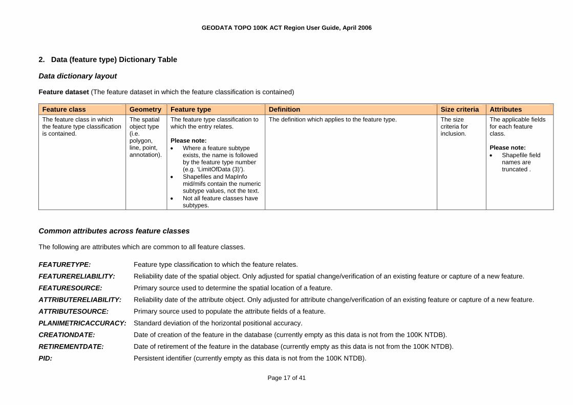
2. Data (feature type) Dictionary Table Data dictionary layout Feature dataset (The feature dataset in which the feature classification is contained) Feature class Geometry Feature type Definition Size criteria Attributes The feature class in which the feature type classification is contained.
The spatial object type (i.e. polygon, line, point, annotation).
The feature type classification to which the entry relates. Please note: • Where a feature subtype
exists, the name is followed by the feature type number (e.g. ‘LimitOfData (3)’).
• Shapefiles and MapInfo mid/mifs contain the numeric subtype values, not the text.
• Not all feature classes have subtypes.
The definition which applies to the feature type. The size criteria for inclusion.
The applicable fields for each feature class. Please note: • Shapefile field
names are truncated .
Common attributes across feature classes The following are attributes which are common to all feature classes. FEATURETYPE: Feature type classification to which the feature relates.
FEATURERELIABILITY: Reliability date of the spatial object. Only adjusted for spatial change/verification of an existing feature or capture of a new feature.
FEATURESOURCE: Primary source used to determine the spatial location of a feature.
ATTRIBUTERELIABILITY: Reliability date of the attribute object. Only adjusted for attribute change/verification of an existing feature or capture of a new feature.
ATTRIBUTESOURCE: Primary source used to populate the attribute fields of a feature.
PLANIMETRICACCURACY: Standard deviation of the horizontal positional accuracy.
CREATIONDATE: Date of creation of the feature in the database (currently empty as this data is not from the 100K NTDB).
RETIREMENTDATE: Date of retirement of the feature in the database (currently empty as this data is not from the 100K NTDB).
PID: Persistent identifier (currently empty as this data is not from the 100K NTDB).
Page 17 of 41

GEODATA TOPO 100K ACT Region User Guide, April 2006
SYMBOL: Symbol number that relates to the feature. (Refer to the Symbol Dictionary).
MAPNUMBER: Number that defines the map index to which the feature is related
Data dictionary Administration (Feature dataset) Feature class Geometry Feature type Definition Size criteria Attributes
Prohibited Area Boundary Line (1)
The boundary of a prohibited area.
Reserve Boundary Line (2) The line bounding a Reserves feature class polygon.
AdministrationBoundaries Line
Limit Of Data (3) The line bounding the limits of known source material or the edge of the defined NTDB.
TYPE FEATUREWIDTH TEXTNOTE
ProhibitedAreas Polygon Prohibited Area Area into which entry is prohibited without permission from the controlling authority.
707m2
(500,000sqm) NAME AUTHORITY
Forestry Reserve (2) Public land reserved for forestry purposes. 707m2
(500,000sqm) Nature Conservation Reserve (3) Land reserved for the conservation of native species. 707m2
(500,000sqm) Indigenous Reserve (1) Land reserved due to its Indigenous significance excluding
freehold land. 707m2
(500,000sqm)
Reserves Polygon
Water Supply Reserve (4) Land reserved to protect water supply catchments. 707m2
(500,000sqm)
TYPE NAME AUTHORITY
Aviation Feature class Geometry Feature type Definition Size criteria Attributes AircraftFacilityAreas Polygon Tarmac (1) A well constructed surface upon which aircraft take off and
land, associated with a licenced Aerodrome or Airport. TYPE
NAME TEXTNOTE
Taxiway (4) A route for the movement of Aircraft and vehicles which service them.
AircraftFacilityLines Line
Landing Ground (3) A paved or cleared strip on which aircraft take off and land.
TYPE NAME TEXTNOTE
AircraftFacilityPoints Point Heliport (2) A constructed and maintained area for Helicopter take off and landing.
TYPENAME FEATUREWIDTH
Page 18 of 41

GEODATA TOPO 100K ACT Region User Guide, April 2006
Feature class Geometry Feature type Definition Size criteria Attributes ORIENTATION
AirportAreas Polygon Airport Area An area set aside for use as a licenced facility by the Civil Aviation Safety Authority for the movement of aircraft and the receipt and discharge of cargo and passengers.
NAME
Cartography Feature class Geometry Feature type Definition Size criteria Attributes Annotations Annotation Annotation Type that appears on the map not related to the graticule or
grid feature classes. MAPNUMBER+ specific annotation attributes (No SYMBOL)
Salt Evaporator Internal Line (6) A levee bank or small canal within a salt evaporator. 500m (5mm on map)
Tropic Of Capricorn (8) The parallel of latitude 23°26.5'S.
Runway Centreline (5) A symbol used to indicate the length and orientation of an airport’s runway.
Settling Pond Internal Line (7) Levee banks within settling ponds. 500m (5mm on map)
Pointer (4) A symbol used to graphically link text to a feature where the density of detail may result in ambiguity.
Lock Line (9) A line used to complete the representation of a lock and ensure the impression of an obstruction across the full width of the water passage (i.e a watercourse area).
Runway Edge (12) A line defining the limits of a landing ground, runway or tarmac.
International Boundary (3) Boundaries defining the territorial sovereignty of a country. The international boundary will be taken to be the line of sea bed jurisdictions.
CartographicLines Line
Arrow (1) A symbol at the neatline of the map within the margin indicating the direction of a road’s destination or objective.
TYPE MAPNUMBER TEXTNOTE
Transition Point (6) The point where a road or railway enters/exits a tunnel.
Road Marker State (5) The symbol printed over a road indicating a state route.
Distance Indicator (1) A symbol used to indicate points between which road distances are given (in kilometres).
CartographicPoints Point
Road Marker National (4) The symbol printed over a road indicating a national route.
TYPE MAPNUMBER FEATUREWIDTH ORIENTATION TEXTNOTE
Page 19 of 41

GEODATA TOPO 100K ACT Region User Guide, April 2006
Feature class Geometry Feature type Definition Size criteria Attributes Flow Direction Arrow (2) A symbol used to indicate the direction of flow of water
through a river system where it is unclear using the topological relationships shown on the map face.
GraticuleAnnotations Annotation Graticule Annotation Type that appears on the map related to the Graticule feature class.
MAPNUMBER+ specific annotation attributes (no SYMBOL)
Graticules Line Graticule A line on a map or chart representing a parallel of latitude or a meridian of longitude including cross ticks.
MAPNUMBER
GridAnnotations Annotation Grid Annotation Type that appears on the map related to the Map Grid feature type.
MAPNUMBER+ specific annotation attributes (no SYMBOL)
Grids Line Map Grid A line forming part of a rectangular Cartesian coordinate system that is superimposed on maps and charts to permit identification of ground locations with respect to other locations and the computation of direction and distance to other points.
MAPNUMBER
Culture Feature class Geometry Feature type Definition Size criteria Attributes AerialCableways Line Aerial Cableway A conveyor system in which carrier units run on wire cables
strung between supports. 300m (3mm on map)
NAME TEXTNOTE
CemeteryAreas Polygon Cemetery Area An area of land for burying the dead. 150m2
(22,500sqm) NAME TEXTNOTE
CemeteryPoints Point Cemetery Point An area of land for burying the dead NAME FEATUREWIDTH ORIENTATION TEXTNOTE
DamWalls Line Dam Wall A barrier of earth and rock, concrete or masonry constructed to form a reservoir for water storage purposes or to raise the water level.
100m (1mm on map)
NAME FEATUREWIDTH TEXTNOTE
Signage (3) A Sign or Signage structure which has been designated as a useful or informative feature during an emergency response or rescue mission by emergency service representatives.
EmergencyFacilityPoints Point
Water Access (4) A device or construction to enable the transfer or use of stored water in an emergency situation.
TYPE AUTHORITY DESCRIPTION IDCODE ORIENTATION
Page 20 of 41

GEODATA TOPO 100K ACT Region User Guide, April 2006
Feature class Geometry Feature type Definition Size criteria Attributes Rescue Point (2) A location designated as a suitable or acknowledged rescue
and recovery point by emergency service representatives.
Communication Device (1) A device to provide communication services, generally in remote locations, during an emergency response or rescue mission.
TEXTNOTE
Fences Line Fence A structure which encloses, bounds or divides a property or part thereof. Includes vermin proof fences.
1,000m (10mm on map)
FEATUREWIDTH TEXTNOTE
LandmarkAreas Polygon Landmark Area Man-made or defined permanent features having landmark value or useful for navigation.
200m2
(40,000sqm) NAME DESCRIPTION TEXTNOTE
Recreation Area (8) A general purpose or large park in a residential area. 150m2
(22,500sqm) Civic Square (1) A normally rectangular formal open area within a town
centre, usually surrounded by buildings, designated by the towns governing body for use by its citizens.
150m2
(22,500sqm)
Golf Course (3) An area of land developed and purposely designed for the playing of golf.
150m2
(22,500sqm) Multiple Use (4) An area of land developed for a combination of recreational
purposes. 150m2
(22,500sqm) Show Ground (10) Show ground arenas and buildings for the formal
presentation of primary production and related activities. 150m2
(22,500sqm) Miscellaneous Area (5) An area of land developed for miscellaneous or undefined
recreational purposes. 150m2
(22,500sqm) Oval Area (6) An area of land developed as a sporting ground for the
playing of football, athletics, cricket and the like. 150m2
(22,500sqm) Gardens (2) Formally laid out public botanical or ornamental grounds. 150m2
(22,500sqm) Race Course (7) An area of land allocated & developed for the racing of
horses. 150m2
(22,500sqm)
RecreationAreas Polygon
Rifle Range (9) An area specifically designated for rifle shooting. 150m2
(22,500sqm)
TYPE NAME TEXTNOTE
RubbishTips Polygon Rubbish Tip An area above ground for the disposal of rubbish. 150m2
(22,500sqm) TEXTNOTE
VerticalObstructions Point Vertical Obstruction Prominent man-made features of a permanent nature that either have landmark value, are useful for navigation or may constitute a danger to aircraft. Such features will have a height above the local terrain.
NAMEDESCRIPTION HEIGHT FEATUREWIDTH ORIENTATION
Page 21 of 41

GEODATA TOPO 100K ACT Region User Guide, April 2006
Feature class Geometry Feature type Definition Size criteria Attributes TEXTNOTE
WaterTanks Point Water Tank A feature constructed on or below the ground for the storage of water.
NAMEFEATUREWIDTH ORIENTATION TEXTNOTE
Windpumps Point Windpump A tower fitted with a wind-driven pump. NAME FEATUREWIDTH ORIENTATION TEXTNOTE
Yards Point Yard A small area of land enclosed by a fence and generally used for confining stock.
NAMEFEATUREWIDTH ORIENTATION TEXTNOTE
Drainage Feature class Geometry Feature type Definition Size criteria Attributes CanalLines Line Canal Line An artificial watercourse conveying water for inland
navigation, irrigation or drainage purposes. 500m (5mm on map)
NAME TEXTNOTE
Locks Point Lock An enclosure in a water body with gates at both ends to raise or lower the water level to enable vessels to pass from one level to another.
NAMEFEATUREWIDTH ORIENTATION TEXTNOTE
RapidLines Line Rapid Line An area of broken, fast flowing water in a watercourse, where the slope of the bed increases (but without a prominent break of slope which might result in a waterfall), or where a gently dipping bar of harder rock outcrops.
100m (1mm on map)
TEXTNOTE
Spillways Line Spillway A channel or duct formed around the side of a reservoir past the end of the dam, to convey flood discharge from the watercourse above the reservoir into the watercourse below the dam.
100m (1mm on map)
TEXTNOTE
Watercourse (2) A natural channel along which water may flow from time to time.
1,000m (10mm on map)
WatercourseLines Line
Connector (1) An artificial line used to connect linear Hydrographic features across an area feature to allow network analysis of riverine networks.
TYPE NAME PERENNIALITY HIERARCHY TEXTNOTE
Page 22 of 41

GEODATA TOPO 100K ACT Region User Guide, April 2006
Feature class Geometry Feature type Definition Size criteria Attributes WaterfallPoints Point Waterfall Point A sudden descent of water over a step or ledge in the bed of
a watercourse. NAME
FEATUREWIDTH ORIENTATION TEXTNOTE
Framework Feature class Geometry Feature type Definition Size criteria Attributes
Shoreline (2) A line depicting the boundary of a mainland, island or sea.
Junction (1) An artificial line used to separate adjacent hydrographic areas which have differing attributes and across which flow can occur.
State Border (3) The boundary defining the division of the Commonwealth of Australia into State/Territory administrations.
FrameworkBoundaries Line
Limit Of Data (4) The line bounding the limits of known source material or the edge of the defined NTDB.
TYPE
Islands Polygon Island An area of land fully surrounded by the sea. 25m2
(625sqm) NAME STATE
LargeAreaFeatures Polygon Large Area Feature A representation that is indicative of the extent of nationally recognized significant regions.
NAME
Place Name (9) A named place or area.
Waterbody Island (8) A named island within an inland waterbody or forming part of the shoreline.
Mountain (5) A named markedly elevated landform bounded by steep slopes and rising to prominent ridges and individual peaks.
Pass (6) A named low and passable gap through a mountain range.
Cape (3) A named prominent headland projecting into the sea or inland waterbody.
Beach (2) A named strip of land or terrace bordering the sea, usually lying between high and low tides.
Bay (1) A named wide, open and curving indentation into the land formed by the sea or inland waterbody.
Road Junction (7) A named intersection of two or more roads.
Locations Point
Gorge (4) A named deep and narrow, steep-sided, usually rocky river valley.
TYPE NAME FEATUREWIDTH ORIENTATION TEXTNOTE
Mainlands Polygon Mainland The area of continental Australia including Tasmania. STATE
Page 23 of 41

GEODATA TOPO 100K ACT Region User Guide, April 2006
Feature class Geometry Feature type Definition Size criteria Attributes Seas Polygon Sea The water area surrounding the Australian continent and its
offshore islands. OCEANNAME
SEANAME OTHERWATERNAME
Habitation Feature class Geometry Feature type Definition Size criteria Attributes BuildingAreas Polygon Building Area A permanent walled and roofed construction or the ruin of
such a construction, capable of being represented at scale. 150m2
(22,500sqm) NAME BUILDINGFUNCTION CLASS TEXTNOTE
BuildingPoints Point Building Point A permanent walled and roofed construction or the ruin of such a construction.
NAMEBUILDINGFUNCTION CLASS FEATUREWIDTH ORIENTATION TEXTNOTE
BuiltUpAreas Polygon Built Up Area An area where buildings are close together and have associated road and other infrastructure networks.
250m2
(62,500sqm) NAME
Homesteads Point Homestead A named prominent building or set of buildings which is/are the place of permanent residence in rural areas.
NAMEFEATUREWIDTH ORIENTATION TEXTNOTE
PopulatedPlaces Point Populated Place A named settlement with a population of 200 or more persons.
NAMEFEATUREWIDTH ORIENTATION TEXTNOTE
Industry Feature class Geometry Feature type Definition Size criteria Attributes Conveyors Line Conveyor A continuous belt or series of belts mounted on rollers and
used to move large quantities of goods, especially grain or ore.
300m (3mm on map)
TEXTNOTE
MineAreas Polygon Mine Area An excavation made by the removal of stone, gravel, clay or mineral from the ground for commercial or industrial purposes and tailings dumps from mining operations.
150m2
(22,500sqm) NAME TEXTNOTE
Page 24 of 41

GEODATA TOPO 100K ACT Region User Guide, April 2006
Feature class Geometry Feature type Definition Size criteria Attributes MinePoints Point Mine Point An excavation for the extraction of minerals. NAME
FEATUREWIDTH ORIENTATION TEXTNOTE
PetroleumWells Point Petroleum Well A pipe sunk in the ground for the purpose of obtaining subterranean oil or gas.
FEATUREWIDTHORIENTATION TEXTNOTE
StorageTanks Point Storage Tank Large vessel for the storage of liquids (not water) or gases, usually associated with refineries or chemical plants.
NAMEFEATUREWIDTH ORIENTATION TEXTNOTE
Marine Feature class Geometry Feature type Definition Size criteria Attributes ForeshoreFlats Polygon Foreshore Flat That part of the seabed or estuarine areas, between mean
high water and the line of lowest astronomical tide. 250m2
(62,500sqm)
Shoal (2) A detached area of any material the depth over which constitutes a danger to surface navigation of marine craft. The term shoal is not generally used for dangers which are composed entirely of rock or coral.
250m2
(62,500sqm) MarineHazardAreas Polygon
Reef (1) An area of rock or coral that is exposed between mean high water and lowest tide, or just below approximate lowest tide, which is visually prominent or a hazard to shipping.
250m2
(62,500sqm)
TYPE NAME RELATIONSHIP TEXTNOTE
Offshore Rock (1) A rock located offshore that represents a hazard to shipping. MarineHazardPoints Point
Wreck (2) A disabled vessel, either submerged or visible, which is attached to, or foul of, the bottom or cast up on the shore.
TYPE NAME RELATIONSHIP FEATUREWIDTH ORIENTATION TEXTNOTE
Wharf Line (5) A structure built from the land parallel to shore to provide for the berthing of vessels.
100m (1mm on map)
Sea Wall (4) A solid structure usually of concrete masonry or earth, built to prevent erosion or encroachment by the sea.
100m (1mm on map)
Boat Ramp Line (1) A sloping construction to facilitate launching or retrieving vessels from water.
100m (1mm on map)
MarineInfrastructureLines Line
Breakwater (2) A solid structure to break the force of the waves, sometimes detached from the coast, protecting a harbour or anchorage.
100m (1mm on map)
TYPE NAME TEXTNOTE
Page 25 of 41

GEODATA TOPO 100K ACT Region User Guide, April 2006
Feature class Geometry Feature type Definition Size criteria Attributes Jetty (3) A structure projecting into a body of water for use as a
promenade or as a platform alongside which vessels may be secured for loading and unloading passengers/cargo.
100m (1mm on map)
Lighthouse (8) A building or structure housing a light used as a navigation aid to shipping.
MarineInfrastructurePoints Point
Dry Dock Point (6) A structure or basin providing support for a vessel and from which water can be removed so that the bottom of the vessel is exposed.
150m2
(22,500sqm)
TYPE NAME FEATUREWIDTH ORIENTATION TEXTNOTE
Physiography Feature class Geometry Feature type Definition Size criteria Attributes Caves Point Cave A naturally formed, subterranean open area or chamber. NAME
FEATUREWIDTH ORIENTATION TEXTNOTE
Craters Polygon Crater A bowl shaped natural depression with steep slopes at the rim, formed by volcanic activity or meteor impact.
100m2
(10,000sqm) NAME TEXTNOTE
Distorted Surface (1) An area over which vehicular movement is difficult or impossible due to the fractured nature of the ground, or rock debris lying on the surface.
250m2
(62,500sqm) DeformationAreas Polygon
Outcrop (2) An area of land where large rocks or boulders protrude from or rest on the surface.
250m2
(62,500sqm)
TYPE NAME TEXTNOTE
Cutting (2) An open excavation of the Earth's surface to provide passage for a road, railway, canal or similar entity.
½ contour int. and 200m long (2mm on map)
Cliff (1) A high, steep, significant or overhanging face of rock. 500m (5mm on map)
Embankment (3) An artificial bank of earth and or stone built above the natural surface.
½ contour int. and 200m long (2mm on map)
Levee (4) A low earth wall erected to restrain flood waters or to contain irrigation water.
2m high and 200m long (2mm on map)
Discontinuities Line
Razorback (8) A long and narrow upland with steep sides. 500m (5mm on map)
TYPE TEXTNOTE
Pinnacles Point Pinnacle A tall, slender spire shaped rock; projecting from a level or gently sloping surface, or the top of a mountain.
NAMEFEATUREWIDTH
Page 26 of 41

GEODATA TOPO 100K ACT Region User Guide, April 2006
Feature class Geometry Feature type Definition Size criteria Attributes ORIENTATION TEXTNOTE
SandRidges Line Sand Ridge Sand drifts in long ridges tending parallel to and elongating in the direction of the prevailing winds.
100m (1mm on map)
AVERAGEHEIGHT
Sand Dune (2) Mounds of loose sand usually crescent shaped transverse to the prevailing winds.
250m2
(62,500sqm) Sands Polygon
Sand Area (1) An area predominantly covered with sand and devoid of vegetation.
250m2
(62,500sqm)
TYPE
Rail transport Feature class Geometry Feature type Definition Size criteria Attributes RailwayBridgePoints Point Railway Bridge Point A structure erected over a depression or obstacle to carry
rail traffic. FEATUREWIDTH
ORIENTATION TEXTNOTE
Railway Bridge Line (1) A structure erected over a depression or obstacle to carry rail traffic.
40m (.4mm on map)
Railway Overpass (3) A separation of surface levels constructed to prevent direct intersection with other rail or road networks.
40m (.4mm on map)
RailwayCrossingLines Line
Railway Causeway (2) An embankment of earth or masonry erected across open water or area subject to inundation and carrying a railway.
200m (2mm on map)
TYPE FEATUREWIDTH TEXTNOTE
Railways Line Railway A transportation system using one or more rails to carry freight or passengers.
500m (5mm on map)
NAME GAUGE STATUS TRACKS TEXTNOTE
RailwayStopPoints Point Railway Station (1) A recognised stopping place for trains where passengers may board or alight or freight be loaded or unloaded. There may or may not be a platform. The railway station may not be in use.
TYPENAME FEATUREWIDTH ORIENTATION TEXTNOTE
RailwayTunnelLines Line Railway Tunnel Line An artificial underground/ or underwater passage carrying a railway.
100m (1mm on map)
FEATUREWIDTH TEXTNOTE
RailwayTunnelPoints Point Railway Tunnel Point An artificial underground or underwater passage carrying a railway.
FEATUREWIDTH ORIENTATION TEXTNOTE
Page 27 of 41

GEODATA TOPO 100K ACT Region User Guide, April 2006
Relief Feature class Geometry Feature type Definition Size criteria Attributes
Standard Contour (5) A line which represents an imaginary line on the ground joining points of equal elevation in relation to the AHD.
Interpolated Contour (4) A line which represents an imaginary line on the ground joining points of equal elevation in relation to the AHD. Interpolated contour to be utilised to join discontinued contours or to replace a contour absent in the source material for cartographic reasons. This feature type is not to be utilised where contours have been broken for cliffs.
Depression Contour (3) A line which represents an imaginary line on the ground joining points of equal elevation in relation to the AHD. Depression contours are to be utilised where a portion of a landform dips below its surrounding area crossing a contour interval. The depression must be fully contained within the surrounding landform.
Connector Standard (2) A line which represents an imaginary line on the ground joining points of equal elevation in relation to the AHD. Connector Standard is to be utilised where the contour’s position is not known, for example in a Watercourse Area or Mine Area.
Connector Discontinuity (1) A line which represents an imaginary line on the ground joining points of equal elevation in relation to the AHD. Connector Discontinuity is to be utilised where contours on the repromat were broken for either a cliff, cutting, embankment or razorback symbol.
Limit Of Data (6) The line bounding the limits of known source material or the edge of the defined NTDB.
Contours Line
Auxiliary Contour (7) A line augmenting relief presentation where significant topographic features are not shown by the prescribed contour interval. The line represents an imaginary line on the ground joining points of equal elevation in relation to the AHD.
500m (5mm on map)
TYPE ELEVATION
HypsometricAreas Polygon Hypsometric Area The area enclosed between adjacent contours, with the exception of auxiliary contours.
ELEVATION
SpotElevations Point Spot Elevation A point on the earth’s surface, of known elevation, above or below the AHD.
CLASSELEVATION FEATUREWIDTH ORIENTATION
Page 28 of 41

GEODATA TOPO 100K ACT Region User Guide, April 2006
Road transport Feature class Geometry Feature type Definition Size criteria Attributes
Grid (2) A grid at the opening in a fence to prevent livestock crossing but allowing for the free passage of vehicles.
BarrierPoints Point
Gate (1) An opening in a fence or wall for the passage of vehicles, people or animals and which may contain a device to limit passage.
TYPE FEATUREWIDTH ORIENTATION TEXTNOTE
FerryRouteLines Line Ferry Route Line A route across a river, lake, reservoir or sea used by a vessel for the regular transport of vehicles or passengers from one terminal point to another.
NAMETEXTNOTE
FootBridges Line Foot Bridge A structure erected over a depression or obstacle to carry foot traffic.
100m (1mm on map)
TEXTNOTE
FootTracks Line Foot Track A track designed to carry pedestrian traffic only. 500m (5mm on map)
NAME TEXTNOTE
Road Causeway (3) An embankment of earth or masonry erected across open water or an area subject to inundation and carrying a road.
200m (2mm on map)
Road Bridge Line (2) A structure erected over a depression or obstacle to carry road traffic.
40m (.4mm on map)
Road Overpass (5) A separation of surface levels constructed to prevent direct intersection with other road or rail networks.
40m (.4mm on map)
RoadCrossingLines Line
Ford Line (1) A shallow or flat portion of the bed of a watercourse or lake where a crossing may be effected.
TYPE FEATUREWIDTH TEXTNOTE
Ford Point (1) A shallow or flat portion of the bed of a watercourse or lake where a crossing may be effected.
RoadCrossingPoints Point
Road Bridge Point (2) A structure erected over a depression or obstacle to carry road traffic.
TYPE FEATUREWIDTH ORIENTATION TEXTNOTE
Roads Line Road A route for the movement of vehicles, people or animals. 500m (5mm on map)
NAME CLASS FORMATION NRN SRN FEATUREWIDTH TEXTNOTE
RoadTunnelLines Line Road Tunnel Line An artificial underground or underwater passage carrying a road.
100m (1mm on map)
FEATUREWIDTH TEXTNOTE
RoadTunnelPoints Point Road Tunnel Point An artificial underground or underwater passage carrying a road.
FEATUREWIDTHORIENTATION TEXTNOTE
Page 29 of 41

GEODATA TOPO 100K ACT Region User Guide, April 2006
Series index Feature class Geometry Feature type Definition Size criteria Attributes GeodataIndexes Polygon GeodataIndex The line defining the limits of each GEODATA product tile
supplied to the public. TILENUMBER
TILENAME MapIndexes Polygon Map Index An area defined for the production of a single map sheet
whether as a singular production or as part of a series such as the National Topographic Map Series.
LAYOUTGUIDEMAPNUMBER
Survey marks Feature class Geometry Feature type Definition Size criteria Attributes HorizontalControlPoints Point Horizontal Control Point A point on the ground, the geographical position of which
has been determined by geodetic survey. NAME
ELEVATION CODE ORDEROFACCURACY FEATUREWIDTH ORIENTATION TEXTNOTE
Utility Feature class Geometry Feature type Definition Size criteria Attributes Pipelines Line Pipeline A pipe used for carrying gases and/or liquids. 500m
(5mm on map) NAME PRODUCT RELATIONSHIP TEXTNOTE
Powerlines Line Powerline Wire or wires supported on poles, towers or pylons, used for the transmission of high voltage electricity.
1,000m (10mm on map)
TEXTNOTE
Vegetation Feature class Geometry Feature type Definition Size criteria Attributes ClearedLines Line Cleared Line A graded path in a straight line. 1,000m
(10mm on TEXTNOTE
Page 30 of 41

GEODATA TOPO 100K ACT Region User Guide, April 2006
Feature class Geometry Feature type Definition Size criteria Attributes map)
Orchard (1) An area covered by an orderly planting of trees, vines or bushes which yield fruits, nuts or other edible products.
250m2
(62,500sqm) CultivatedAreas Polygon
Plantation (2) Intensively managed stands of trees of either native or exotic species, created by the regular placement of seedlings or seeds.
250m2
(62,500sqm)
TYPE PRODUCT TEXTNOTE
Mangrove (2) A dense growth of mangrove trees, which grow to a uniform height on mud flats in estuarine or salt waters. The land upon which the mangrove is situated is a nearly level tract of land between the low and high water lines.
250m2
(62,500sqm)
Forest Or Shrub (1) An area of land with woody vegetation greater than 10% foliage cover (includes trees and shrubs).
200m2
(40,000sqm)
NativeVegetationAreas Polygon
Rainforest (3) Vegetation community which contains key rainforest species, with a foliage cover greater than 70%.
250m2
(62,500sqm)
TYPE COVERDENSITY GROWTHFORM TEXTNOTE
Windbreaks Line Windbreak A narrow strip of natural or planted trees, or scrub, positioned so as to break the force of the prevailing wind.
500m (5mm on map)
Waterbodies Feature class Geometry Feature type Definition Size criteria Attributes Bores Point Bore A small diameter hole in the ground for the purpose of
obtaining subterranean water by natural flow or mechanical pumping.
NAME FEATUREWIDTH ORIENTATION TEXTNOTE
CanalAreas Polygon Canal Area An artificial watercourse conveying water for inland navigation, irrigation or drainage purposes.
224m2
(50,000sqm) NAME TEXTNOTE
Marine Swamp (2) That low lying part of the backshore area of tidal waters, usually immediately behind saline coastal flat, which maintains a high salt water content, and is covered with characteristic thick grasses and reed growths.
200m2
(40,000sqm)
Swamp (4) Land which is so saturated with water that it is not suitable for agricultural or pastoral use and presents a barrier to free passage.
500m2
(250,000sqm)
Saline Coastal Flat (3) That nearly level tract of land between mean high water and the line of the highest astronomical tide.
250m2
(62,500sqm)
Flats Polygon
Land Subject To Inundation (1) Low Iying land usually adjacent to lakes or watercourses, which is regularly covered with flood water for short periods.
250m2
(62,500sqm)
TYPE NAME TEXTNOTE
Page 31 of 41

GEODATA TOPO 100K ACT Region User Guide, April 2006
Feature class Geometry Feature type Definition Size criteria Attributes Lakes Polygon Lake A naturally occurring body of mainly static water surrounded
by land. 100m2
(10,000sqm) NAME PERENNIALITY TEXTNOTE
Settling Pond (3) Shallow beds, usually segmented by constructed walls, for the treatment of sewage or other wastes.
250m2
(62,500sqm) Aquaculture Area (1) Shallow beds, usually segmented by constructed walls, for
the use of aquaculture. 250m2
(62,500sqm)
PondageAreas Polygon
Salt Evaporator (2) A flat area, usually segmented, used for the commercial production of salt by evaporation.
250m2
(62,500sqm)
TYPE TEXTNOTE
RapidAreas Polygon Rapid Area An area of broken, fast flowing water in a watercourse, where the slope of the bed increases (but without a prominent break of slope which might result in a waterfall), or where a gently dipping bar of harder rock outcrops.
100m (1mm on map)
TEXTNOTE
Town Rural Storage (2) A body of water collected and stored behind a constructed barrier for some specific use (with the exception of Flood Irrigation Storage).
150m2
(22,500sqm) Reservoirs Polygon
Flood Irrigation Storage (1) A body of water collected and stored behind a constructed barrier for the specific use of Flood Irrigation Farming
150m2
(22,500sqm)
TYPE NAME TEXTNOTE
Springs Point Spring A place where water issues from the ground naturally. NAME FEATUREWIDTH ORIENTATION TEXTNOTE
Canal Boundary Line (1) A line completing the boundary of a canal area feature dependant on its hierarchy in the WaterbodyBoundaries feature class.
Limit Of Data (9) The line bounding the limits of known source material or the edge of the defined NTDB.
Rapid Boundary Line (6) The line used to complete the boundary of a rapid area polygon which has not yet been addressed by other features in the WaterbodyBoundaries feature class.
Watercourse Boundary Line (8) A line depicting the boundary of a Watercourse Area feature.
Reservoir Boundary Line (7) A line completing the boundary of a Reservoir feature dependant on its hierarchy in the WaterbodyBoundaries feature class.
Lake Boundary Line (4) A line completing the boundary of a Lake feature dependant on its hierarchy in the WaterbodyBoundaries feature class.
WaterbodyBoundaries Line
Flat Boundary Line (2) A line completing the boundary of a feature in the Flats feature class dependant on its hierarchy in the WaterbodyBoundaries feature class.
TYPE
Page 32 of 41

GEODATA TOPO 100K ACT Region User Guide, April 2006
Feature class Geometry Feature type Definition Size criteria Attributes Pondage Boundary Line (5) A line completing the boundary of a feature in the
PondageAreas feature class dependant on its hierarchy in the WaterbodyBoundaries feature class.
Junction (3) An artificial line used to separate adjacent hydrographic areas which have differing attributes and across which flow can occur.
WatercourseAreas Polygon Watercourse Area A natural channel along which water may flow from time to time.
316m2
(100,000sqm) NAME PERENNIALITY HIERARCHY TEXTNOTE
Waterholes Point Waterhole A natural depression which holds perennial water, within a non-perennial watercourse or a non-perennial lake.
NAMEPERENNIALITY FEATUREWIDTH ORIENTATION TEXTNOTE
Rockhole (4) A hole excavated in solid rock by water action.
Pool (3) A small body of still or standing water, permanent or temporary in an isolated natural depression, not within Watercourses.
Gnamma Hole (1) Small holes of varying shape, diameter and depth, found in hard granite outcrops and in the decomposed granite of a breakaway, which can and usually does hold water.
Native Well (2) An isolated natural depression which holds water, not within Watercourses. The natural phenomena is sometimes improved by indigenous persons for their own water collection purposes.
WaterPoints Point
Soak (5) A depression holding moisture after rain, especially the damp or swamp spots around the base of granite rocks.
TYPE NAME FEATUREWIDTH ORIENTATION TEXTNOTE
Page 33 of 41

GEODATA TOPO 100K ACT Region User Guide, April 2006
Appendix B: Item Formatting and Attribution Attribute items are populated in accordance with the table below. The item name and item type is listed, together with a sample attribute and the case of the attribute where applicable (ie. for text strings). Case is assigned as per the following abbreviations in the table:
C Caps only CL Caps & Lower L Lower case N/A Not Applicable MR Annotation item - to be shown in the same case as required for map production
Note:
• The following list represents the total number of items existing for all feature classes in the geodatabase. Therefore, more items are shown than what would normally appear against each individual feature class.
• Individual feature classes are not identified in this table. This list is intended to provide information on the format and attribution of all attribute items in the geodatabase. The items are alphabetically ordered for ease of reference, and are not shown in the order they appear in the geodatabase model.
Feature Class Item Name
Item Type Allow Nulls
Precision Scale Length Example Attribute
Case
ANNOTATIONCLASSID Long Integer Yes 10 <null> N/A ATTRIBUTERELIABILITY Date Yes 0 0 36 1/10/2000 N/A ATTRIBUTESOURCE String Yes 0 0 50 GEOSCIENCE
AUSTRALIA C
AUTHORITY String Yes 100 State Forestry Commission
CL
AVERAGEHEIGHT Short Integer Yes 2 6 N/A BUILDINGFUNCTION String No 50 Police Station CL CLASS String No 40 Secondary Road CL CODE String Yes 24 NSW1274 C COVERDENSITY String Yes 20 Sparse CL CREATIONDATE Date Yes 0 0 36 16/11/2003 N/A DALIGN String Yes 10 LEFT C DESCRIPTION String Yes 30 tower L DFIT String Yes 4 OFF C DID Long Integer Yes 9 14 N/A DJUSTIFY String Yes 2 LR C DLEVEL Long Integer Yes 9 1 N/A DOFFSETX Double Yes 18 11 300 N/A DOFFSETY Double Yes 18 11 20 N/A DSIZE Double Yes 18 11 787.5 N/A DSYMBOL Long Integer Yes 9 10 N/A DTEXT String Yes 254 No. 19 Bore MR ELEMENT Blob Yes 0 0 21474
83647 Images & general graphics etc
N/A
ELEVATION Double No 7 2 250 N/A ELEVATIONACCURACY Short Integer No 4 25 N/A FEATURECLASSNAME String Yes 50 Sea C/L FEATUREID Long Integer Yes 10 14744 N/A FEATURERELIABILITY Date Yes 0 0 36 1/02/2000 N/A
Page 34 of 41

GEODATA TOPO 100K ACT Region User Guide, April 2006
Feature Class Item Name
Item Type Allow Nulls
Precision Scale Length Example Attribute
Case
FEATURESOURCE String Yes 0 0 50 GEOSCIENCE AUSTRALIA
C
FEATURETYPE String No 32 Pipeline CL FEATUREWIDTH Double Yes/No
(variable) 8 4 0.25 N/A
FORMATION String No 18 Unsealed CL GAUGE String No 20 Standard: 1435mm CL GROWTHFORM String Yes 20 Mallee Shrub CL HEIGHT Float Yes 6 2 51.82 N/A HIERARCHY String No 14 Minor CL MAPNAME String Yes 60 PORT PHILLIP
SPECIAL C
MAPNUMBER String Yes/No (variable)
8 H5002 C
NAME String Yes/No (variable)
60 ALBURY C
NRN String Yes 12 A31, 26 N/A OBJECTID (system generated)
Object ID 2453 N/A
OCEANNAME String Yes 60 SOUTH PACIFIC OCEAN
C
ORIENTATION Short Integer Yes 3 135 N/A OTHERWATERNAME String Yes 60 BASS STRAIT C PERENNIALITY String No 14 Non-perennial CL PID Long Integer Yes 8 83202692 N/A PLANIMETRICACCURACY Short Integer No 4 100 N/A RELATIONSHIP String Yes 12 Underground CL RETIREMENTDATE Date Yes 0 0 36 12/01/2004 N/A SEANAME String Yes 60 ARAFURA SEA C SHAPE Geometry Yes Polygon N/A SHAPE.AREA Double No 0 0 0.738476 N/A SHAPE.LEN Double No 0 0 0.409136 N/A SOURCETYPE String No 24 PRINTED MAP C SRN String Yes 12 M13, 64 N/A STATE String No 3 NSW C STATUS String No 18 Operational CL SYMBOL Short Integer No 4 209 N/A TEXTNOTE String Yes 50 gauge 1435mm L TILENAME String Yes 60 MELBOURNE C TILENUMBER String No 8 F5416 C TRACKS String No 8 One CL TYPE Long Integer No 5 2 N/A TYPE_DESCRIPTION String No 32 NatureConservation
Reserve CL
ZORDER Long Integer Yes 10 0 N/A
Page 35 of 41

GEODATA TOPO 100K ACT Region User Guide, April 2006
Appendix C: Metadata DATASET
Title: GEODATA TOPO 100K ACT Region Custodian: Geoscience Australia Jurisdiction: Australia
DESCRIPTION
Abstract: GEODATA TOPO 100K ACT Region is a vector data representation of the ACT Region NATMAP 1:100,000 (100K) scale topographic map and has been developed to conform to Geoscience Australia's Topographic Data and Map Specifications Version 4.0, February 2006. Themes include: Administation; Aviation; Cartography; Culture; Drainage; Framework; Habitation; Industry; Physiography; Rail transport; Relief; Road transport; Series index; Survey marks; Utility; Vegetation; and Waterbodies. It has been specifically designed for use in Geographic Information Systems (GIS) and provides high quality data for mapping and GIS professionals. The data is available in three popular GIS formats (ESRI Personal Geodatabase, ESRI Shapefiles and MapInfo mid/mifs) as well as a raster (ECW).
Search Words:
BOUNDARIES ENERGY FORESTS HERITAGE Natural HUMAN ENVIRONMENT LAND
MARINE TRANSPORTATION UTILITIES VEGETATION WATER
Geographic Bounding Box: North Latitude: -35 South Latitude: -40 East Longitude: 149.5 West Longitude: 148.5
Geographic Extent Polygon: 148.5 -35, 149.5 -35, 149.5 -36, 148.5 -36, 148.5 - 35
DATA CURRENCY Beginning Date: Not Known
Ending Date: 31DEC2005 DATASET STATUS Progress: Complete Maintenance and Update Frequency: As required ACCESS
Stored Formats: DIGITAL egeodatbas Enterprise Geodatabase Geographic GDA94 GRS80
Available Formats: DIGITAL pgeodatbas Personal Geodatabase Geographic GDA94 GRS80 DIGITAL mif MapInfo Interchange Format (MIF) Geographic GDA94 GRS80 DIGITAL shp ArcView shape file Geographic GDA94 GRS80 DIGITAL ecw ER Mapper Enhanced Compressed Wavelet (ECW) Geographic GDA94 GRS80
Page 36 of 41

GEODATA TOPO 100K ACT Region User Guide, April 2006
Access Constraint:
The data is subject to Commonwealth of Australia Copyright. A licence agreement is required and a licence fee is also applicable for packaged data.
DATA QUALITY Lineage:
GEODATA TOPO 100K ACT Region was generated from the 100K ACT Region NATMAP hardcopy map released in early 2005. The map was revised from previous editions and revision material including: - SPOT and Landsat satellite imagery; - Revision data (i.e. airfields, vegetation, dams, utilities, foot tracks, mines, railways and towers); - Reproduction material (i.e. map production material from previous maps); and - Public feedback. The digital files used to create the map were converted to topographic data to be in line with Version 4.0 Specifications.
Positional Accuracy: The positional accuracy is the statistical estimate of the degree to which planimetric coordinates and elevations of features agree with their world values. It is impacted by three sources of errors: positional accuracy of the source material; errors due to the conversion processes; and errors due to the manipulation processes. This represents an errors of 34 meters on the ground for 100K data. Alternative and equal ways of expressing this error is 'not more than 10% of well defined points will be in error by more than 56m for 100K data'.
Attribute Accuracy: Attribute accuracy is a measure of the degree to which the attribute values of features agree with the information on the source material. The allowable error in attribute accuracy ranges from 0.5% to 5%, at a 99% confidence level. Where less than 1% of attribute errors are permissible the entire population is tested. Where a less stringent limit is set for allowable errors, a random subset of the relevant features is tested.
Logical Consistency:
Logical consistency is a measure of the degree to which data complies with the technical specification. This involves tests to check that the table and file/field names are set out as in the data dictionary. It also involves graphical test to check intersections, polygon closure, minimum sizes of polygons and topological relationships. The allowable error in logical consistency ranges from 0% to 5%.
Completeness: All instances of a feature and its attribute values that appear on the source material have been captured unless otherwise indicated in the selection criteria for that feature.
CONTACT INFORMATION Contact Organisation: Geoscience Australia Contact Person: Director, Sales and Distribution, CIMA Contact Mail Address: GPO Box 378 Canberra ACT 2601 Telephone: +61 2 6249 9966 Facsimile: +61 2 6249 9960 Electronic Mail Address: [email protected] METADATA DATE: 07APR2006 ADDITIONAL METADATA:
Size of dataset: 201MB for personal geodatabase and around 100MB for Shapefiles and Mid/Mifs. Scale/resolution: 1:100 000
Page 37 of 41

GEODATA TOPO 100K ACT Region User Guide, April 2006
Glossary Term Definition Accuracy The degree of conformity with a standard, or the degree of perfection attained in a
measurement. Accuracy relates to the quality of a result, and is distinguished from precision, which relates to the quality of the operation by which the result is obtained.
Aerodrome An area for the movement of aircraft and for the receipt and discharge of cargo. Aerodromes may be licensed by Airservices Australia.
Airport Technically an aerodrome at which facilities exist for the shelter, servicing and repair of aircraft, and at which major navigation aids are installed. Note: Airport is used generically in these specifications to include licensed Aerodromes.
Alignment The direction or position of a linear feature (e.g., road or railway), on a map in relation to surrounding topographic detail.
Approximate Very near, fairly correct, near to the actual. ‘Approximate Position’ is used as a descriptive note on a map to indicate detail, the position of which cannot be determined to the accuracy of the map accuracy statement.
Area feature A feature, which is portrayed as a region or surface. An area feature is bounded by one or more polygons.
Attribute A descriptive characteristic of a feature. An attribute has a defined set of attribute values.
Attribute object The attribute object holds the non-locational information about the feature instance
Australian Height Datum (AHD)
The datum used for the determination of elevation in Australia. The determination used a national network of benchmarks and tide gauges and set Mean High Water as zero elevation.
Azimuth The azimuth of a point is the angle reckoned clockwise in a horizontal plane between the local meridian and that point.
Chart A special purpose-map, generally designed for navigation or other particular purposes, in which essential map information is combined with other data critical to the intended use.
Compilation The production of a new or revised map or chart, or portion thereof, from existing maps, aerial photographs, satellite imagery; surveys, and other source data.
Connector feature An artificial linear feature used to connect a linear network across an area feature. This allows continuity of the feature and assists the process of linear network analysis.
Control A collective term for a system of marks or objects on the earth or on a map or photograph, whose positions or elevations, or both, have been determined.
Datum A point, plane, or surface to which systems of measurement are referred or related to one another. Hence:
• GEOCENTRIC DATUM A reference frame which has its origin as the Earth’s centre of mass, which is directly related to the orbits of satellites. Positioning from these satellites is a critical element in modern surveying, mapping, geographic information systems, navigation, aviation, land and sea transport, emergency services, law enforcement and recreation.
• GEODETIC DATUM The position of a reference spheroid as defined by the position of one selected station, usually near the centre of the survey area, known as the origin, and the azimuth from the origin to an adjoining station.
• VERTICAL DATUM A level surface to which elevations are referred, usually, but not always, mean sea level.
Edge The interior and exterior definition of polygon extents inherent in the construction of the polygon. (In terms of this specification it is not used to indicate the related bounding line feature (geometry type line))
Elevation Vertical distance from a datum, usually Mean Sea Level to a point or object on the earth’s surface.
Enterprise geodatabase (egdb)
A geodatabase stored in a Relational Database Management System (RDBMD) which is accessed through an ArcSDE client via ArcGIS. It enables multi-user viewing and editing. Geoscience Australia’s working national topographic geodatabase is stored as an egdb.
Feature Cartographic feature. Spatial data feature. An abstraction of a real world phenomenon selected properties of which are illustrated on a map or held as spatial digital data.
Feature class A group of features defined by a set of rules and which have common characteristics and
Page 38 of 41

GEODATA TOPO 100K ACT Region User Guide, April 2006
relationships that are properties of the corresponding real world phenomena.
Feature instance An occurrence of a feature class that has a unique set of attribute and relationship values.
Gauge A dimensional standard, especially the distance between the two inside edges of the rails of a railway line.
Gauge (railway) Broad gauge 1600 mm Narrow gauge 1067 mm Standard gauge 1435 mm
GDA94 See Geocentric Datum of Australia (GDA94)
Generalisation A process by which features which cannot be separated at a given map scale are displaced from their true positions or simplified for the sake of cartographic clarity.
Geocentric Datum of Australia (GDA94)
Geocentric Datum of Australia 1994. A geocentric datum used for the determination of geographic co-ordinates. GDA94 is now in use for GEODATA TOPO 250K Series 2 and 3 products and GEODATA TOPO 100K ACT Region as well as associated topographic map products.
GEODATA The commercial name adopted by Geoscience Australia, for its range of quality digital data products.
Geographical coordinates
A position given in terms of latitude and longitude.
Geoscience Australia An Australian Government Agency responsible for geoscience research and geospatial information.
GIS Geographic Information System. A spatial database, which is manipulated with a set of spatial operators or commands.
Graticule A network of lines on a map or chart representing the parallels of latitude and meridians of longitude of the earth.
Grid Two sets of parallel lines intersecting at right angles and forming squares; a rectangular Cartesian coordinate system that is superimposed on maps, charts, and other similar representations of earth’s surface in an accurate and consistent manner to permit identification of ground locations with respect to other locations and the computation of direction and distance to other points.
Height The vertical distance from the base to the top.
Heliport A constructed and maintained landing area for helicopters.
Highest astronomical tide
The highest tide level, which can be predicted to occur under average meteorological conditions and under any combination of astronomical conditions.
Horizontal Control A network of stations of known positions referred to a common horizontal datum (in Australia, AGD) and which control the horizontal position of mapped features.
Hydrography Those features both natural and constructed of which water is the main constituent, either permanently or intermittently. Also, a GEODATA theme consisting of features pertaining to the drainage and run-off of water.
Infrastructure A GEODATA theme consisting of features pertaining to transportation systems and also includes named localities and places.
Landing ground Unlicensed facility with clearly marked runway but no airport facilities.
Latitude The latitude of a place is its angular distance on a Meridian, measured northwards or southwards from the terrestrial Equator.
Layer Subdivision of a theme into one or more layers of data on the basis of topological relationships. Linear networks, polygons and point/line features are placed in separate layers.
Longitude A linear or angular distance measured east or west from a reference meridian (usually Greenwich) on a sphere or spheroid.
Lowest astronomical tide
The lowest level, which can be predicted to occur under average meteorological conditions and under any combination of astronomical conditions. For reasons of safety lowest Astronomical Tide is the datum used by Navy’s Hydrographic Surveys.
Map A representation of part or whole of the earth’s surface usually to scale showing both natural and artificial features.
Map series A group of map sheets usually having the same scale and cartographic specifications and collectively identified by the producing agency.
Map sheet An individual map, either complete in itself or part of a series.
Margin The area of a map sheet, which lies outside the Neatline.
Page 39 of 41

GEODATA TOPO 100K ACT Region User Guide, April 2006
Mean High Water (MHW)
The average height of all high waters at a place over an 18.6 year period. On small and medium scale maps MHW coincides with the coastline.
Meridian A Great Circle arc of 180° terminated by the geographic poles.
MHW See Mean High Water (MHW).
Minor road Access, residential or local road.
National park An area subject to strict control of the activities, which may take place in it, and under Government supervision to maintain its value to the public.
National Topographic Database (NTDB)
A database containing detailed spatial and attribute information on a national basis, its primary focus being on topographic information. The NTDB currently comes in two scales (1:250,000 and 1:100,000) and is managed by its custodian Geoscience Australia.
National Topographic Map Series (NTMS)
A civilian map series comprising a set of consistent topographic maps nationwide, at scales of 1:100 000 and 1:250 000.
NATMAP A product name for topographic 1:100 000 and 1:250 000 scale map products using the NATMAP product name.
Neatline A line, usually on the grid or graticule, which encloses the detail of a map.
Node A point that is a junction of two or more lines or which is the end point of a line.
Node/line structure The structuring of linear features in a theme layer so that they consist of lines broken by nodes at intersections or at the point where an attribute of the feature changes.
Non-perennial Contains water for several months of each year or only contains water intermittently.
Parallel A Small Circle parallel to the equator, on which all points have the same Latitude.
Perennial Where an area normally contains water for the whole year, except during unusually dry periods, in at least nine years out of ten.
Personal geodatabase (pgdb)
A geodatabase stored in a Microsoft Access database which can be accessed directly by the ArcGIS suite of products. It enables multi-user viewing, but single-user editing. GEODATA TOPO 100K ACT Region is provided as a pgdb.
Polygon A set of lines used to define the boundaries of an area. There is one external polygon and there may be one or more internal, non-nested polygons.
Positional accuracy Statistical estimate of the degree to which planimetric co-ordinates and elevations of features agree with their real world values.
Principal road Highway, regional and through road.
Prohibited area An area into which entry is prohibited without the prior permission of the controlling authority.
Relief (GEODATA) A GEODATA theme consisting of features defining the elevation and shape of the terrain.
Relief The deviation of an area of the earth’s surface from a plane. It refers to the physical shape of the surface of the earth.
Repromat Material, generally in the form of positive or negative copies on film of each colour plate, from which a map may be reprinted without redrafting.
Scale The relationship between the distance on a photograph, map or other graphic to its corresponding distance on the ground or to another graphic. See also Representative Fraction.
Secondary road Linking and distributor road.
Segment A direct line between a pair of vertices or a vertice and a node.
Source material Data of any type required for the production of maps and charts including, but not limited to ground control, aerial and terrestrial photographs, satellite imagery, sketches, maps and charts; meteorological information; intelligence documents and written reports pertaining to natural and constructed features of the area to be mapped or charted.
Spatial object The spatial object holds the locational information of a feature instance. For GEODATA it is composed of either a point, node, line or polygon.
Specification A document, which sets out the standards to be adhered to in, the production of a particular dataset, map or map series. This generally contains information, which describes or represents data structure, the sheet layout, marginal information, symbols, lettering and colours to be adopted.
State forest A tract of forest land gazetted as such by a government.
Symbol A letter, character or other graphic device representing some feature, quality or characteristic on a map.
Terrain A tract of country considered with regard to its natural features and configuration.
Page 40 of 41

GEODATA TOPO 100K ACT Region User Guide, April 2006
Theme The information contained in the map production material is divided into four themes, which contain logically related geographic information (Hydrography, Infrastructure Relief and Vegetation). Each theme is capable of being used as a data set in its own right.
Tile The area of a spatial database included in a data transfer.
Tile Edge An artificial linear feature, which indicates the boundaries of the tile. The tile edge closes off polygon features, which are situated in more than one tile.
Topographic map A map whose principal purpose is to portray and identify the features of the Earth’s surface as faithfully as possible within the limitations imposed by scale.
Topography The detailed description, especially on a map, of a locality; including its relief and any relatively permanent objects, whether natural or of human origin, thereon. The configuration of a surface, including its relief, the position of its streams, lakes, roads, cities, and other features. The earth’s natural and physical features collectively.
Track (railway) The number of sets of rails.
Track (vehicular) Public or private roadway of minimum or no construction, not necessarily maintained.
UFI Unique Feature Identifier.
Vegetation A GEODATA theme consisting of features describing the vegetation cover.
Vertice An intermediate point on a line for which coordinates are held in the data.
Page 41 of 41