Embed Size (px)
Citation preview


Developments in Petroleum Science, 4
GEOMORPHOLOGY OF OIL AND GAS FIELDS IN SANDSTONE BODIES

FURTHER TITLES IN THIS SERIES
1 A. GENE COLLINS GEOCHEMISTRY O F OILFIELD WATERS
2 W.H. FERTL ABNORMAL FORMATION PRESSURES
3 A.P. SZILAS PRODUCTION AND TRANSPORT O F OIL AND GAS
5 T.F. YEN and G.V. CHILINGARIAN OIL SHALE

Developments in Petroleum Science, 4
GEOMORPHOLOGY OF OIL AND GAS FIELDS IN SANDSTONE BODIES
C.E.B. CONYBEARE
Australian National University, Canberra (A. C. T. )
ELSEVIER SCIENTIFIC PUBLISHING COMPANY Amsterdam - Oxford - New York 1976
ELSEVIER SCIENTIFIC PUBLISHING COMPANY 335 Jan van Galenstraat P.O. Box 211, Amsterdam, The Netherlands
AMERICAN ELSEVIER PUBLISHING COMPANY, INC. 5 2 Vanderbilt Avenue New York, New York 10017
Library 01 C0ngrr.a Calaloging in Publication Data
Conyheare, C E B Geomorphology of o i l and gas f i e l d s i n sandstone
bodies.
(Developments i n petroleum science ; 4 ) Includes h ib l iographica l re ferences and indexes. 1. Geornorphology. 2. Rock t r a p s (Hydraulic
engineer ing) 3. Sandstone. 4. Petroleum-Geology. 5. Gas, Natural-Geology. I. T i t l e . 11. Ser ies . GB406. c63 553' .B 7537974 ISBN O-~!+I&-lJ.398-7
Copyright b 1976 by Elsevier Scientific Publishing Company, Amsterdam
AH rights reserved. No part of this publication may be reproduced, stored in a retrieval system, or transmitted in any form or by any means, electronic, mechanical, photocopying, recording, or otherwise, without the prior written permission of the publisher, Elsevier Scientific Publishing Company, Jan van Galenstraat 3 3 5 , Amsterdam
Printed in The Netherlands

ACKNOWLEDGEMENTS
The author wishes to acknowledge the assistance of Ms P.M. Carle, Ms E.A. Kilner, Mr L. Seeuwen and Mr G.R. Harper in the preparation of the typescript and illustrations. Acknowledgement is also due to the following organizations, institutions, and publishers from whose publications the quota- tions and many of the illustrations in this book have been drawn: Geological Society of America, American Association of Petroleum Geologists, Society of Economic Paleontologists and Mineralogists, Canadian Society of Petroleum Geologists, Canadian Institute of Mining and Metallurgy, Royal Geological and Mining Society of the Netherlands, Australian Petroleum Exploration Association, Four Corners Geological Society, Delaware Geological Society, Rocky Mountains Association of Geologists, Wyoming Geological Association, Houston Geological Society, Gulf Coast Association of Geological Societies, Dallas Geological Society, Tulsa Geological Society, Kansas Geological Society- United States Geological Survey, U.S. Bureau of Reclamation, U.S. Navy Hydrographic Office, Mississippi River Commission, Illinois Geological Survey, Indiana Geologcal Survey, Geologische Dienst der Nederlanden, U.S.S.R. Ministry of Oil Industries, University of Texas, Schlumberger Well Services, Nedra Press (U.S.S.R.), John Wiley and Sons, Prentice-H'dl, Princeton University Press, Chapman and Hall, Springer-Verlag, Gulf Publishing Company, Tracer Petroleum and Mining Publications, and Elsevier Scientific Publishing Company.
The author also wishes to acknowledge the facilities offered to him during visiting appointments a t the University of Calgary and the Colorado School of Mines.
PREFACE
This book is essentially about stratigraphic traps for oil and gas. Many of the examples discussed are geomorphologic features having inherent closures without any secondary structural element; others are primarily geomorpho- logic features modified by folding or faulting to produce local closures. The first category comprises traps that are purely stratigraphic, although the accu- mulation of hydrocarbons may have been assisted by regional or local tilting of the strata, or by deformation caused by compaction of the underlying sedi- ments. The second category, which includes a much larger number of known examples, comprises structural-stratigraphic traps. Many of these traps have proved to be elusive, particularly those of the first category which commonly defy detection by seismic methods. In some cases, discovery has been ac- cidental, and further exploration to delineate the accumulation has been empirical.
geological characteristics of geomorphologic features that have controlled or influenced the accumulation of oil and gas in particular fields, with a view to using such examples as models in the search for new fields in sandstone bodies. Many of the examples presented have been so well documented that they stand as classic examples of stratigraphic fields in which oil and gas accumula- tions are controlled by geomorphologic features. Others have yet t o be defined unequivocally, but are included as additional references to assist in the inter- pretation of geophysical and sub-surface geological data.
The author is indebted to the many geologists who have written about the hydrocarbon accumulations and geological features described herein, without whose efforts it would not have been possible to compile this book.
The purport of this book is to briefly present examples illustrating the main
Canberra, A.C.T. C.E.B. CONYBEARE

CONTENTS
Preface . . . . . . . . . . . . . . . . . . . . . . . . . . Acknowledgements . . . . . . . . . . . . . . . . . . . . . . . .
Introduction . . . . . . . . . . . . . . . . . . . . . . . . .
Chapter 1 . River channels . . . . . . . . . . . . . . . . . . . . Introduction . . . . . . . . . . . . . . . . . . . . . . . . .
E-log characteristics . . . . . . . . . . . . . . . . . . . . .
Ancient sand bodies . . . . . . . . . . . . . . . . . . . . . . Pulaski and Fayettville Channels. Tennessee . . . . . . . . . . . . . Bedford Channels. Ohio . . . . . . . . . . . . . . . . . . . Anvil Rock Channel. Illinois . . . . . . . . . . . . . . . . . . Carbondale Channel. Illinois . . . . . . . . . . . . . . . . . . Graham Channels. Texas . . . . . . . . . . . . . . . . . . . Bartlesville Channels. Kansas . . . . . . . . . . . . . . . . . . Shinarump Charinels. Utah . . . . . . . . . . . . . . . . . .
Oil and gas fields . . . . . . . . . . . . . . . . . . . . . . . . Red Earth Oil Field. Alberta . . . . . . . . . . . . . . . . . . Music Mountain Oil Pool. Pennsylvania . . . . . . . . . . . . . . Cabin Creek Gas Field. Ohio . . . . . . . . . . . . . . . . . . Gay-Spencer Richardson Trend. Virginia . . . . . . . . . . . . .
Tyler Oil Fields. Montana . . . . . . . . . . . . . . . . . . . Delaware Extension Oil Field. Oklahoma . . . . . . . . . . . . . . Bush City Oil Field. Kansas . . . . . . . . . . . . . . . . . . Red Fork Sandstone Production. Oklahoma . . . . . . . . . . . . . Moomba Gas Field. South Australia . . . . . . . . . . . . . . . Pickanjinnie Gas Field. Queensland . . . . . . . . . . . . . . . . Moonie Oil Field. Queensland . . . . . . . . . . . . . . . . . Athabasca Oil Sands. Alberta . . . . . . . . . . . . . . . . . . Bellshill Lake and Hughenden Oil Fields. Alberta . . . . . . . . . . . South Glenrock Oil Field. Wyoming . . . . . . . . . . . . . . .
Donkey Creek. Rozet. and O’Connor Oil Fields. Wyoming . . . . . . . . Coyote Creek and Miller Creek Oil Fields. Wyoming . . . . . . . . . . Reimers-Lane-Hart Trend. Nebraska . . . . . . . . . . . . . . . Cut Bank Oil Field. Montana . . . . . . . . . . . . . . . . . . Nahorkatiya Oil Field. Assam . . . . . . . . . . . . . . . . . Maikop Oil Field. U.S.S.R. . . . . . . . . . . . . . . . . . .
Chapter 2 . Distributary and delta-fringe sand . . . . . . . . . . . . . Introduction . . . . . . . . . . . . . . . . . . . . . . . .
Geomorphology . . . . . . . . . . . . . . . . . . . . . . E-log characteristics . . . . . . . . . . . . . . . . . . . . .
Ancient sand bodies . . . . . . . . . . . . . . . . . . . . . . Appalachian Delta. U.S.A. . . . . . . . . . . . . . . . . . .
Geomorphology . . . . . . . . . . . . . . . . . . . . . .
Compaction . . . . . . . . . . . . . . . . . . . . . . .
Jackpile Channel. New Mexico . . . . . . . . . . . . . . . . .
Bethel Sandstone Trend. Kentucky . . . . . . . . . . . . . . . . .
Recluse Oil Field. Wyoming . . . . . . . . . . . . . . . . .
Compaction . . . . . . . . . . . . . . . . . . . . . . .
V VI
1
13 13 13 17 23 26 27 28 31 33 36 36 37 39 40 41 43 45 47 48 50 52 54 56 60 62 64 66 69 73 76 79 80 82 84 88 90
93 93 93
103 106 107 108

VIII
Cisco Delta. Texas . . . . . . . . . . Volgograd Delta. U.S.S.R. . . . . . . . . Identification of delta distributary channel sands
Oil and gas fields . . . . . . . . . . . . Booch Sandstone Oil Fields. Oklahoma South Pine Hollow Gas Fields. Oklahoma . . Pokrovsk Oil Field. U.S.S.R. . . . . . . . East Tuskegee Oil Field. Oklahoma . . . . . Dale Consolidated Oil Field. Illinois Bellshill Lake Oil Field. Alberta . . . . . . Belly River Pool. Pembina Oil Field. Alberta . Asiefere and Eriemu Oil Fields. Nigeria Wilcox Oil and Gas Fields. Texas . . . . . Seeligson Oil Field. Texas . . . . . . . . Ostra Oil Field. Venezuela . . . . . . . Main Pass Block 35 Oil Field. Louisiana
. . .
. . . .
. . .
. . .
. . . . . . . . . . . 110
. . . . . . . . . . . 112
. . . . . . . . . . . 113
. . . . . . . . . . . 117
. . . . . . . . . . . 118
. . . . . . . . . . . 121
. . . . . . . . . . . 123
. . . . . . . . . . . 124
. . . . . . . . . . . 126
. . . . . . . . . . . 127
. . . . . . . . . . . 129
. . . . . . . . . . . 131
. . . . . . . . . . . 133
. . . . . . . . . . . 134
. . . . . . . . . . . 137
. . . . . . . . . . . 138
Chapter 3 . Barrier and other offshore bars . . Introduction . . . . . . . . . . . .
Geomorphology . . . . . . . . . . E-log characteristics . . . . . . . . . Compaction . . . . . . . . . . .
Ancient sand bodies . . . . . . . . . . Oil and gas fields . . . . . . . . . . .
Austin Gas Field. Michigan . . . . . .
Wakiti Trend. Oklahoma . . . . . . . Olympic Oil Field. Oklahoma . . . . . Matu-Catu Trend. Brazil . . . . . . . Bell Creek Oil Field. Montana . . . . . GasDraw Oil Field. Wyoming . . . . . Garrington and Crossfield Oil Fields. Alberta Bisti Oil Field. New Mexico . . . . . . Salt Creek-Teapot Dome Oil Field. Wyoming BigPiney Gas Field. Wyoming . . . . . Hardin Oil Field. Texas . . . . . . .
Shira Streak Oil Field. Pennsylvania
Sallyards Trend Oil Fields. Kansas
. . .
. . . .
. . . . . . . . . . . . 141
. . . . . . . . . . . . 141
. . . . . . . . . . . . 141
. . . . . . . . . . . . 147
. . . . . . . . . . . . 147
. . . . . . . . . . . . 151
. . . . . . . . . . . . 152
. . . . . . . . . . . . 153
. . . . . . . . . . . . 155
. . . . . . . . . . . . 158
. . . . . . . . . . . . 159
. . . . . . . . . . . . 161
. . . . . . . . . . . . 161
. . . . . . . . . . . . 164
. . . . . . . . . . . . 169
. . . . . . . . . . . . 169
. . . . . . . . . . . . 174 , . . . . . . . . . . . 176 . . . . . . . . . . . . 179 . . . . . . . . . . . . 181
Chapter 4 . Regressive marine shoreline sand . . . . . . . . . . . . . . 183 Introduction . . . . . . . . . . . . . . . . . . . . . . . . 183
Geomorphology . . . . . . . . . . . . . . . . . . . . . . 183 E-log characteristics . . . . . . . . . . . . . . . . . . . . . 192
Ancient sand bodies . . . . . . . . . . . . . . . . . . . . . . 197 Oil and gas fields . . . . . . . . . . . . . . . . . . . . . . . 199
Wattenberg Gas Field, Colorado . . . . . . . . . . . . . . . . . 200 Burbank Oil Field. Oklahoma . . . . . . . . . . . . . . . . . 202 Viking Oil and Gas Fieids. Alberta and Saskatchewan . . . . . . . . . . 203 Sabre Oil Field. Colorado . . . . . . . . . . . . . . . . . . . 208
Chapter 5 . Transgressive marine shoreline deposits . . . . . . . . . . . . 211 Introduction . . . . . . . . . . . . . . . . . . . . . . . . 211
Geomorphology . . . . . . . . . . . . . . . . . . . . . . 211
Compaction . . . . . . . . . . . . . . . . . . . . . . 195

IX
E-log characteristics . . . . . . . . . . . . . . . . . . . . . 213 Compaction . . . . . . . . . . . . . . . . . . . . . . . 214
Ancient sand bodies . . . . . . . . . . . . . . . . . . . . . . 215 Oil and gas fields . . . . . . . . . . . . . . . . . . . . . . . 217
Yardarino.- Dongara Gas Field, Western Australia . . . . . . . . . . . 219 Red Oak, Wilberton. and Kinta Gas Fields. Oklahoma . . . . . . . . . 220 Morrow Oil Fields. Oklahoma . . . . . . . . . . . . . . . . . 221 Milligan Oil Field. British Columbia . . . . . . . . . . . . . . . 224 Horseshoe Oil Field. New Mexico . . . . . . . . . . . . . . . . 227 Carbon Gas Field. Alberta . . . . . . . . . . . . . . . . . . . 231
Chapter 6 . Submarine valleys . . . . . . . . . . . . . . . . . . . 235 Introduction . . . . . . . . . . . . . . . . . . . . . . . . 235
Geomorphology . . . . . . . . . . . . . . . . . . . . . . 235 E-log characteristics . . . . . . . . . . . . . . . . . . . . . 240 Compaction . . . . . . . . . . . . . . . . . . . . . . . 242
Ancient sand bodies . . . . . . . . . . . . . . . . . . . . . . 244 Y oakum Channel Texas . . . . . . . . . . . . . . . . . . . 247 Rosedale Channel . . . . . . . . . . . . . . . . . . . . . 249
Oil and gas fields . . . . . . . . . . . . . . . . . . . . . . . 251 Brentwood. Dutch Slough and Wets Thornton Oil and Gas Fields. California . . 252 Marlin Gas Field. Victoria . . . . . . . . . . . . . . . . . . . 255 Ventura Oil and Gas Field. California . . . . . . . . . . . . . . . 258
Chapter 7 . Tidal current sand bodies . . . . . . . . . . . . . . . . 261 Introduction . . . . . . . . . . . . . . . . . . . . . . . . 261
Geomorphology . . . . . . . . . . . . . . . . . . . . . . 261 E-log characteristics . . . . . . . . . . . . . . . . . . . . . 266 Compaction . . . . . . . . . . . . . . . . . . . . . . . 266
Ancient sand bodies . . . . . . . . . . . . . . . . . . . . . . 267
Chapter 8 . Alluvial fans and sheets . . . . . . . . . . . . . . . . . 273 Introduction . . . . . . . . . . . . . . . . . . . . . . . . 273
Geomorphology . . . . . . . . . . . . . . . . . . . . . . 273 E-log characteristics . . . . . . . . . . . . . . . . . . . . . 277 Compaction . . . . . . . . . . . . . . . . . . . . . . . 278
Ancient sand bodies . . . . . . . . . . . . . . . . . . . . . . 279 Oil and gas fields . . . . . . . . . . . . . . . . . . . . . . . 282
Chapter 9 . Eolian sand . . . . . . . . . . . . . . . . . . . . . 285 Introduction . . . . . . . . . . . . . . . . . . . . . . . . 285
Geomorphology . . . . . . . . . . . . . . . . . . . . . . 285 E-log characteristics . . . . . . . . . . . . . . . . . . . . . 287 Compaction . . . . . . . . . . . . . . . . . . . . . . . 288
Ancient sand bodies . . . . . . . . . . . . . . . . . . . . . . 290 Oil and gas fields . . . . . . . . . . . . . . . . . . . . . . . 291
North Sea Gas Fields . . . . . . . . . . . . . . . . . . . . 292 Hassi R’Mel and Houd Berkaoui Gas and Oil Fields. Algeria . . . . . . . . 294
References . . . . . . . . . . . . . . . . . . . . . . . . . 297
Subject Index . . . . . . . . . . . . . . . . . . . . . . . . 333

This Page Intentionally Left Blank
1
INTRODUCTION
Accumulation of o i l and gas i n a sands tone body depends on s e v e r a l
f a c t o r s i nc lud ing t h e s t a t e of gene ra t ion and t i m e of mig ra t ion o f
hydrocarbons o r t h e i r p r e c u r s o r s , d i r e c t i o n a l v a r i a t i o n s i n p o r o s i t y
and p e r m e a b i l i t y , t h e e x i s t e n c e of s t r a t i g r a p h i c o r s t r u c t u r a l c l o s u r e
wi th a s u i t a b l e s e a l , and t h e geometry of t h e sands tone body. Many
ho le s have been d r i l l e d on t h e b a s i s o f geophys ica l i n t e q r e t a t i o n s t h a t
i n d i c a t e d s t r u c t u r a l c l o s u r e w i t h i n a p r o s p e c t i v e s e c t i o n , on ly t o f i n d
t h e s e c t i o n l ack ing i n s u i t a b l e s o u r c e beds f o r hydrocarbons, o r w i th
no impermeable s e a l above t h e p o t e n t i a l s ands tone r e s e r v o i r . The
sands tone i t s e l f may be l o c a l l y t i g h t . F u r t h e r , t h e s p a t i a l r e l a t i o n -
s h i p s of d e p o s i t i o n a l t r e n d s and geometry t o permeable zones w i t h i n t h e
sands tone body are commonly unknown. To compl ica te our unders tanding of
t h e s i t u a t i o n , t h e d e p o s i t i o n a l t r ends and geometry of t h e sands tone body
i t s e l f may n o t b e known. With t h e s e p o s s i b i l i t i e s i n mind, t h e fo l lowing
comments are o f f e r e d on t h e c l a s s i f i c a t i o n of sands tone bod ies .
A s h e e t o r b l a n k e t sands tone body may b e des igna ted as a mappable
s t r a t i g r a p h i c u n i t , such as a member o r fo rma t ion , and y e t l a c k c o n t i n u i t y
and homogeneity. A t one l o c a l i t y i t may c o n s i s t of a s i n g l e sands tone
u n i t , and a t ano the r i t may comprise two o r more sands tone beds t h a t have
i n d i v i d u a l d e p o s i t i o n a l t r e n d s , shapes , and p e t r o p h y s i c a l c h a r a c t e r i s t i c s .
A t a p a r t i c u l a r l o c a t i o n o i l o r gas may be encountered i n Sandstone "A",
where i t occurs below t h e up-dip edge , bu t no t i n ad jacen t Sandstone "B"
t h a t p inches o u t e l sewhere . This t ype of s i t u a t i o n i s common i n a l l u v i a l
po in t b a r and c h a n n e l - f i l l s ands , i n anastomosing d e l t a d i s t r i b u t a r y sands ,
and i n o f f - l apo ing marine s h o r e l i n e sands .

2
A c l a s s i f i c a t i o n of s a n d body s h a p e s is proposed by P e t t i j o h n ,
P o t t e r and S i e v e r (1972) a f t e r t h e c l a s s i f i c a t i o n of P o t t e r (1962, b ) .
They s a y t h a t t h e r e are a t least f o u r d i f f e r e n t b a s i c r e c u r r i n g s h a p e s
t o sand b o d i e s , i l l u s t r a t e d by F i g . 1-1, and make t h e f o l l o w i n g s t a t e m e n t
on p . 4 4 0 , "Equid imens iona l s a n d b o d i e s h a v e l e n g t h - w i d t h r a t i o s of
a p p r o x i m a t e l y 1:l and may c o v e r a few t o t h o u s a n d s of s q u a r e k i l o m e t e r s .
These h a v e b e e n c a l l e d s h e e t s and b l a n k e t s . E l o n g a t e s a n d b o d i e s , on
t h e o t h e r h a n d , a r e t h o s e w i t h l o n g d imens ion n o t a b l y e x c e e d i n g w i d t h
and a r e one of t h r e e t y p e s : pods , r i b b o n s and d e n d r o i d s ( P o t t e r , 1962,
F ig . 3 ) .
a r e much more e l o n g a t e w i t h length-width r a t i o s of t h r e e o r more and
p o s s i b l y as h i g h as 20 t o 1 o r more. Rich (1923, p. 103) used t h e term
s h o e s t r i n g f o r s u c h b o d i e s .
have b r a n c h e s , e i ther t r i b u t a r i e s o r d i s t r i b u t a r i e s . By l a t e r a l m i g r a t i o n ,
c o a l e s c e n t r i b b o n s and d e n d r o i d s may form belts, d e n d r i t i c b e l t s b e i n g t h e
more common. 'I
-have l e n g t h - w i d t h r a t i o s o f three o r less where r i b b o n s
Dendroids are commonly more s i n u o u s and
S h e e t s
E I o n g a t e
Fig . 1-1 C l a s s i f i c a t i o n of s a n d body s h a p e s . (Modif ied by P e t t i j o h n ,
P o t t e r and S i e v e r , 1972, a f t e r P o t t e r , 1962b) .

3
These des igna t ions are based on t h e geometry of t h e sandstone bodies
and do not have any i m p l i c i t connotat ion as t o
o r geomorphology. Also, they can be misconstrued and misappl ied, w i th
p a r t i c u l a r r e fe rence t o some so-cal led shee t o r b l anke t sandstones.
Nevertheless , they s e r v e a u s e f u l purpose i n q u a l i f y i n g and t o some ex ten t
quan t i fy ing t h e shapes of sandstone bodies .
d e p o s i t i o n a l environment
Sheet- l ike s t r a t i g r a p h i c u n i t s , c o n s i s t i n g e s s e n t i a l l y of sandstone,
may have o r i g i n a t e d as t r a n s g r e s s i v e o r r e g r e s s i v e s h o r e l i n e sands, as
e o l i a n sands , as widespread sand beds w i t h i n coa le sc ing a l l u v i a l f a n s , a s
braided and l a t e r a l l y mig ra t ing e s t u a r i n e d e p o s i t s , a s r i v e r sediments on
a broad p l a i n , o r as l a y e r s of sand swept ou t on abyssa l p l a i n s of t he ocean.
Apart from t h e s i m i l a r i t y of t h e i r g ros s dimensions, t h e s e u n i t s are
markedly d i f f e r e n t i n t h e i r i n t e r n a l s t r u c t u r e and s t r a t i g r a p h i c
r e l a t i o n s h i p s . A l l are diachronous t o some degree , a l though a l a y e r
of sand swept r a p i d l y on t o an abyssa l p l a i n w i l l r e p r e s e n t s o s h o r t
a per iod of t i m e t h a t i t can be regarded a s a s t r a t i g r a p h i c marker bed.
I n t e r n a l l y , a s h e e t - l i k e s t r a t i g r a p h i c u n i t may c o n s i s t of s e v e r a l
d i s t i n c t sandstone bodies t h a t may be l o c a l l y connected o r e n t i r e l y
sepa ra t ed by impermeable s h a l e l a y e r s .
nea r ly equidimensional o r e longa te i n shape.
e longa te s h o r e l i n e sands may have a wide a r e a l d i s t r i b u t i o n wi th in a
comparatively t h i n s t r a t i g r a p h i c i n t e r v a l , and consequently form a sheet-
- l i k e u n i t i n g r o s s dimensions.
o r i e n t a t i o n s of t hese e longa te sandstone bodies are p a r a l l e l t o t h e
o r i g i n a l c o a s t l i n e ; b u t t h e i n t e r v a l may a l s o i n c l u d e o t h e r e longa te
sandstone bod ies , o r i e n t e d approximately normal t o t h e c o a s t l i n e , t h a t
were formed as d i s t r i b u t a r y sands f i l l i n g channels cut i n t o t h e s h o r e l i n e
sands. In many cases t h e d i s t r i b u t a r y sands cannot r e a d i l y be d i s t ingu i shed
from the s h o r e l i n e sands wi th which they are a s s o c i a t e d , although v a r i a t i o n s
These s e p a r a t e bod ie s may be
A sequence of off- lapping,
Within such an i n t e r v a l t h e p re fe r r ed

4
,,, Q ,x
ENVIRONM E NTS
LONGlTUDlNAl
TRANSVERSE
ALLUVIAL
( F L U V I A L )
E O L I A N
Figs. 1-2, 1-3 and 1-4
ALLUVIAL FANS
(APEX, MIDDLE 8 BASE OF F A N )
BRA I DED STREAMS
MEANDERING STREAMS
(ALLUVIAL VALLEY)
DUNES
STREAM FLOWS
VlSCOUS FLOWS
MEANDER B E L T S
F LOODBASINS
COASTAL DUNES
DESERT DUNES
OTHER DUNES
CHANNELS
SHEET F LOODS
“ S I E V E DEPOSITS” 4 I DEBRIS FLOWS 4
M U D FLOWS
CHANNELS (VARYING SIZES)
CHANNELS
NATURAL LEVEES
POlNT BARS
1 STREAMS, LAKES 8 SWAMPS
1
T Y P E S :
TRANSVERSE
S E l F ( LONGlTUDlN AL )
BARCHAN PARABOLIC
DOME-SHAPED
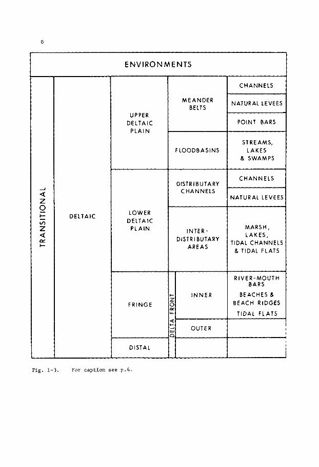
C l a s s i f i c a t i o n of depos i t iona l environments of sand bodies
and t h e i r r e l a t e d geomorphologic fea tures .
1972, and Bernard and Le Blanc, 1965).
( A f t e r Le Blanc,

5
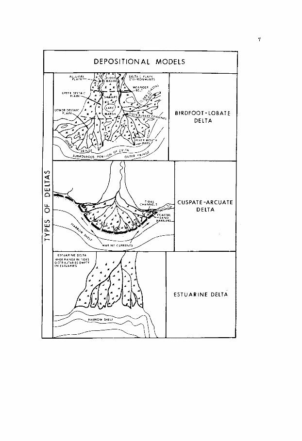
DEPOSIT ION A L MODELS
O R A l D t D C H A N N t L S I W A I H t l l A N D A O A N D O N f D C M A N N f L 5
A L L U V I A L F A N U f N ,
M E A N D E R I N G STREAM
COASTAL DUNES
6
- ?: 1 L L
E N V IRO N M E N T S
I N N E R
2
a Z 0 c- Z
- v,
a pi I-
~~
DELTAIC
UPPER DELTAll
P L A I N
LOWER DELTAIC
P L A I N
F RlNGE
DISTAL
M E A N D E R BELTS
F LOODB A S INS
DlSTR IBUTARY C H A N N E L S
INTER- DISTRIBUTARY
AREAS
CHANNELS
NATURAL LEVEES
POINT BARS
ST REAMS, LAKES
& SWAMPS
C H A N N EL5
NATURAL LEVEE!
MARSH, LAKES,
TIDAL CHANNEL: & TIDAL FLATS
R I V E R - M O U T H BARS
BEACHES & BEACH RIDGES
TIDAL FLATS
F i g . 1-3. For c a p t i o n see p.4 .
7
DEPOSI TlON A L MODELS
B I RDFOOT - LOB ATE DELTA
MARINE C U R R E N l S
ESTUARINE DE1:A
ESTUARINE DELTA
8
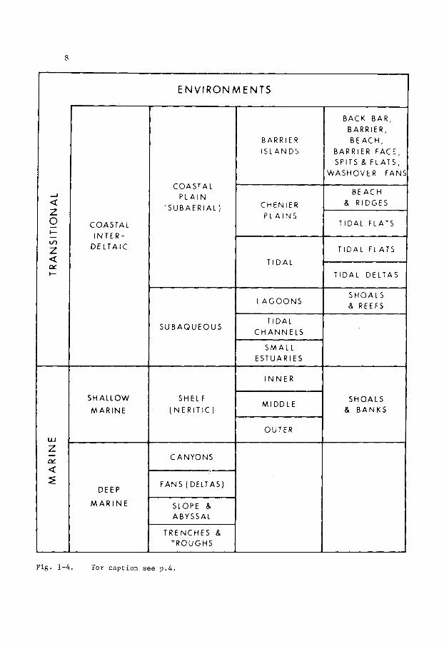
COASTA L I N T E R -
D E L T A I C
S H A L L O W
M A R I N E
DEEP
M A R I N E
E N V l RON M E N T S
COASTAL P L A I N
‘ S U B A E R I A L )
S U B A Q U E O U S
SHELF
( N E R I T I C )
C A N Y O N S
F A N S (DELTAS)
SLOPE 8 ABYSSAL
TRENCHES & TROUGHS
BARRIER I S L A N D S
CHENIER P L A I N S
T I D A L
L A G O O N S
T I D A L C H A N N E L S
S M A L L ESTUAR I E S
INNER
M I D D L E
OUTER
BACK BAR, BARRIER, B E A C H ,
BARRIER FACE, SPITS & F L A T S ,
WASHOVER F A N
B E A C H & R IDGES
T IDAL FLATS
T I D A L FLATS
T I D A L DELTAS
S H O A L S 8 R E E F S
S H O A L S 8 B A N K S
F i g . 1-4. For c a p t i o n see p . 4 .
9
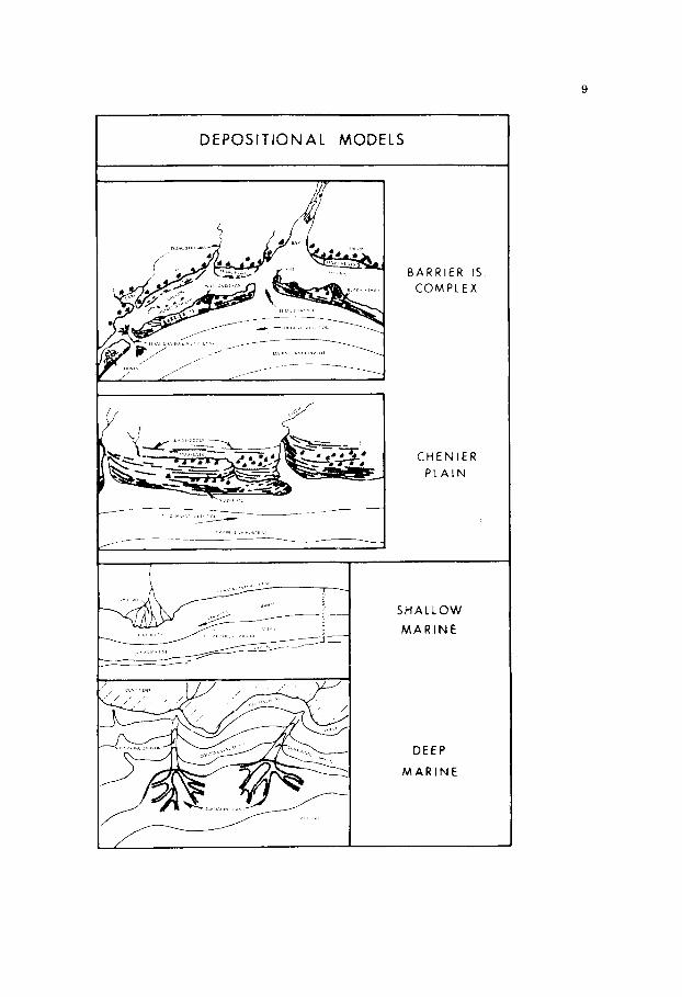
DEPOSITION A L MODELS
B A R R I E R IS . COMPLEX
C H E N I E R P L A I N
SHALLOW
MARINE
D E E P
MARINE

10
in grain gradation, which may be reflected in the geophysical log character-
istics, and in sedimentary structures and fossil content may be diagnostic.
Discrete sandstone bodies may be the products of erosion, such as
elongate strike-valley sands deposited along cuestas, or pod-shaped sand-
stone bodies formed as erosional outliers. Other elongate sandstone bodies,
particularly those that are sinuous or branching, some of which are referred
to as shoestring sands, owe their configuration entirely to depositional
control. Some have been variously interpreted as off-shore bars, barrier
islands, or channel sands depending on the criteria available or current
trend of geological thought.
Le Blanc (1972), after Bernard and Le Blanc (1965), set up a
classification (Figs. 1-2, 1-3 and 1-4) based on depositional environments
and geomorphology. Other classifications have been presented by Laporte
(1968), Selley (1970), Kukal (1971), and Crosby (1972). Le Blanc's
classification depends in part on the geometry of large sedimentary
accumulations such as deltas, barrier island complexes, and submarine fans,
but not on the geometry of individual sandstone bodies. Nevertheless,
where the geometry of a sedimentary accumulation is known, the probable
geometry and depositional trends of sandstone bodies contained within that
accumulation can be inferred. It is important to set up, as early as
possible during the course of exploration, a conceptual model of the
depositional relationships, bearing in mind that the model may be ephemeral
and is certain to be subject to modification. Such a model will serve as
a working basis with which to test the viability o f various interpretations
as new data come to hand.
The usefulness of such a model has been pointed out by Le Blanc
(1972, p. 135) who states, 'The realm of clastic sedimentation can be
divided into several conceptual models, each of which is characterized
by certain depositional environments, sedimentary processes, sequences,

11
and patterns.'
interpretation of geomorphic and environmental origins of oil and gas
fields in sandstone bodies.
This type of approach is of particular value in the
Porosity and permeability trends in sandstone bodies are commonly
influenced or controlled by depositional trends which in turn reflect geo-
morphic influences.
folding or faulting, the stratigraphic factors may be of minor importance to
the distribution of oil and gas.
trap, the sedimentologic and geomorphic factors, considered with reference
to other factors such as regional tilting of the strata and hydro-
dynamics of formation fluids, are additional keys to future exploration
for similar accumulations of hydrocarbons.
Where closure in a sandstone body is effected by
But in the case of a purely stratigraphic

This Page Intentionally Left Blank
13
Chapter 1
R I V E R CHANNELS
I n t r o d u c t i o n
Geomorphology
Channel d e p o s i t s , c o n s i s t i n g of sand , s i l t and c l a y , f i l l t h e
v a l l e y s c u t by a r i v e r system. The e r o s i o n a l s u r f a c e d i s s e c t e d by such
va l l eys may subsequent ly become an unconformity i n t h e s t r a t i g r a p h i c
sequence. The channel d e p o s i t s , which i n c l u d e sed iments f i l l i n g
subs id i a ry channels w i t h i n t h e main channel , can have a ve ry cons ide rab le
a e r i a l e x t e n t , as shown by Fig . 1-5, and i n t h e case of a l a r g e r i v e r
may range i n t h i c k n e s s t o more than 50 m. Within such d e p o s i t s t h e r e
may be numerous p o t e n t i a l t r a p s f o r o i l and gas i n s e p a r a t e sands tone
bodies .
The term channel sand impl i e s a c u t - a n d - f i l l o r i g i n . Channels,
which may have been c u t i n t o o l d e r s t ra ta exposed as an e r o s i o n a l s u r f a c e ,
or i n t o penecontemporaneous sed iments of t h e same r i v e r system, such as
flood p l a i n d e p o s i t s , may subsequent ly b e f i l l e d wi th sand.
l ag between c u t t i n g and f i l l i n g , w i t h i n t h e same r i v e r cour se o r branch ,
may be n e g l i g i b l e and t h e two p rocesses can b e cons idered a s contemporaneous
The t i m e
Channel sands are depos i t ed w i t h i n an a l l u v i a l v a l l e y , o r on t h e
upper p a r t of a d e l t a p l a i n .
d e l t a p l a i n , t h e r i v e r d i s t r i b u t a r i e s form channe l - l i ke sand bodies by a
process of d e p o s i t i o n w i t h i n t h e i r own cour ses , each d i s t r i b u t a r y flowing
out t o sea w i t h i n t h e conf ines of i t s own l evee . D i s t r i b u t a r y sands ,
commonly r e f e r r e d t o as ' s h o e s t r i n g sands' can be d i s t i n g u i s h e d from channel
sands by s e v e r a l c r i t e r i a which w i l l b e d i scussed i n t h e fo l lowing pages.
F a r t h e r down a r i v e r system, on t h e lower
14
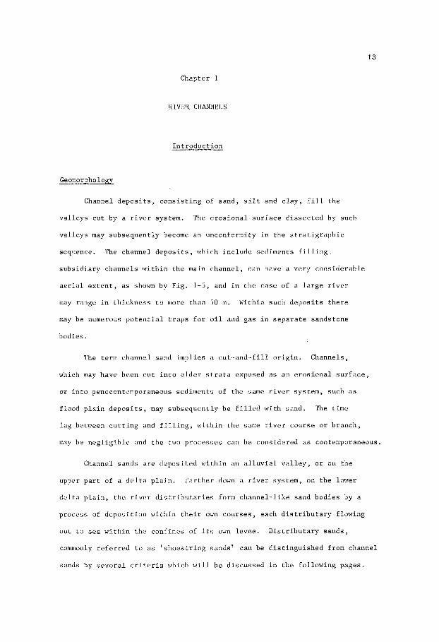
Fig. 1-5 A l l u v i a l v a l l e y and d e l t a p l a i n of t h e M i s s i s s i p p i River .
The a l l u v i a l v a l l e y i s u n d e r l a i n by r i v e r d e p o s i t s commonly
150-200 f e e t (46-61m) t h i c k . (Redrawn from F i s k , 1947).
I n d i v i d u a l sand b o d i e s , f i l l i n g e r o s i o n a l f e a t u r e s c u t by a r i v e r ,
may b e e l o n g a t e o r a r c u a t e depending on t h e course of t h e r i v e r . A s t he
r i v e r cour se undergoes minor changes, t h e s e sand bod ies may be e n t i r e l y
o r p a r t l y re-worked, o r may coa le sce wi th younger sand bod ies t o form a
15
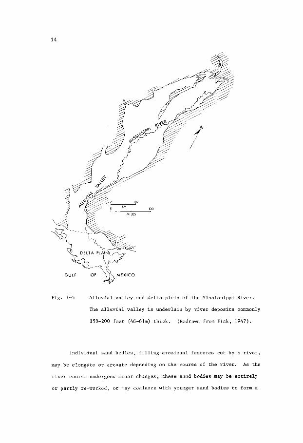
Fig. 1-6 General ized d i s t r i b u t i o n of meander b e l t s of a l a r g e r i v e r
'A' such a s t h e M i s s i s s i p p i , and a s m a l l r i v e r ' B ' .
f a i r l y s t r a i g h t o r meandering b e l t up t o s e v e r a l m i l e s wide (Fig. 1-6).
Such b e l t s have been t r aced i n the subsurface f o r more than 50 km (Figs
1-34, 1-36, 1-44, 1-50, 1-51). Major changes i n a r i v e r course r e s u l t i n
both l a t e r a l s h i f t s of t h e o ld meander b e l t and i n t h e development of new
b e l t s . These may even tua l ly coalesce t o form an anastomosing system of
channel sands wi th in a broad v a l l e y . I n t h e case of a l a r g e r i v e r such
a s the Miss i s s ipp i (Fig. 1 - 5 ) , such a v a l l e y can be up t o 150 km i n width
and 1,000km i n length.

16
It w i l l b e noted t h a t a d i s t i n c t i o n has been made between sand bodies
formed by t h e f i l l i n g of an e r o s i o n a l channel and those formed by a d e l t a
d i s t r i b u t a r y t h a t b u i l d s r a t h e r t han c u t s i t s course . Both sand bod ies
may have s u p e r f i c i a l resemblances in t h a t bo th are narrow, l i n e a r , and
d e p o s i t e d by a r i v e r . On c l o s e r examinat ion , t h e assemblage of g ra in - s i ze
d i s t r i b u t i o n , g r a i n g r a d a t i o n , sed imentary s t r u c t u r e s , and p a l e o n t o l o g i c a l
a s s o c i a t i o n s a f f o r d cr i ter ia which d i s t i n g u i s h t h e i r o r i g i n s . These
f a c t o r s , which have been d e a l t w i t h i n g r e a t d e t a i l i n t h e l i t e r a t u r e ,
w i l l be d i scussed la ter . But i t i s recognized t h a t e r o s i o n a l channels
are a l s o formed and f i l l e d w i t h sand i n s h o r e l i n e environments. The
i n - f i l l i n g sand bod ies are n o t p o i n t b a r d e p o s i t s , a l though they may show
c e r t a i n s imi la r i t i es such as g r a i n g r a d a t i o n and p l a n a r cross-bedding.
The l a t t e r sed imentary f e a t u r e i s common i n e s t u a r i e s where t h e development
of c u t - a n d - f i l l d e p o s i t s of sand is s t r o n g l y in f luenced by t i d a l movements.
Channel s ands , (sensu s t r i c t o ) , are depos i t ed as a l l u v i a l sed iments
i n a r ive r -cu t channel . A s such , they c o n s i s t l a r g e l y o f p o i n t b a r
d e p o s i t s . P o i n t b a r s develop a long t h e i n n e r curve of a main l o o p o r
meander of a r i v e r . A s t h e r i v e r c u t s i n t o t h e bank along t h e o u t e r
edge of i t s cu rve , t h e p o i n t b a r grows by a c c r e t i o n (F ig . 1-7) . The
b a s a l p a r t of t h e p o i n t b a r , c o n s i s t i n g of t h e c o a r s e s t f r a c t i o n s of
t h e load such as coa r se sand , g r i t , and g r a v e l , is depos i t ed ad jacen t
t o the undercut bank i n t h e deepes t p a r t o f t h e r i v e r where t h e c u r r e n t
i s s t r o n g e s t . On t h e more g e n t l y s lop ing i n n e r bank of t h e r i v e r , where
s p i l l - o v e r b a r s and l a r g e r i p p l e s of medium t o f i n e sand a r e formed, t h e
cross-bedded middle p o r t i o n of t h e p o i n t b a r i s depos i t ed . The upper
p o r t i o n of t h e p o i n t b a r i s normally above r i v e r l e v e l and i s formed
dur ing t i m e s of f l ood when heavy loads of f i n e sand , s i l t and mud a r e
depos i t ed i n sha l lower water where t h e v e l o c i t y i s lower than i n t h e na in
channel . The uppermost beds a r e e s s e n t i a l l y h o r i z o n t a l b u t a l s o show

17
SP
0 FEE1
0 500 !50
FEET 0 100 m
Fig . 1-7 Diagramat ic s e c t i o n through a r i v e r p o i n t b a r d e p o s i t t o
i l l u s t r a t e t h e g r a d a t i o n from coa r se sand , g r i t , and g r a v e l
(1) a t t h e b a s e , through cross-bedded sands (2) t o h o r i z o n t a l
and r i p p l e d beds of f i n e sand and s i l t ( 3 ) . The s u r f a c e of t h e
r i v e r i s shown dur ing a low water s t a g e .
a t y p i c a l E-log s e l f - p o t e n f i a l cu rve t o t h e g r a i n g r a d a t i o n
is a l s o shown. The arrow p o i n t s t o t h e d i r e c t i o n of growth
of t h e p o i n t b a r .
The r e l a t i o n s h i p of
small-scale cross-bedding, commonly of t h e c l imbing v a r i e t y i l l u s t r a t e d
by Conybeare and Crook (1968, p l a t e 17) , formed by s m a l l r i p p l e s .
E-log C h a r a c t e r i s t i c s
A s a r i v e r moves back and f o r t h a c r o s s i t s meander b e l t i t c u t s
i n t o o l d e r p o i n t b a r d e p o s i t s and r e d i s t r i b u t e s t h e sed iments . The new
channel may n o t c u t down t o t h e base of t h e o ld . Consequently, w i t h i n
a t h i c k a l l u v i a l s e c t i o n , t h e sequence shown i n F ig . 1-7 could b e
r epea ted i n whole o r i n p a r t s e v e r a l times, bu t always i n t h a t o rde r .
This sequence of g r a i n g r a d a t i o n , from c o a r s e r below t o f i n e r above, is
c h a r a c t e r i s t i c of a l l u v i a l d e p o s i t s and is commonly r e f l e c t e d i n t h e
s e l f - p o t e n t i a l E-log curve as a be l l - shape , o r i n t h e case of s e v e r a l
superimposed b u t incomplete sequences , a s a block-shape. These shapes ,
c h a r a c t e r i s t i c of cu t - and- f i l l sands tone channel d e p o s i t s , commonly show
a marked d e f l e c t i o n a t t h e base of t h e sands tone u n i t , i n d i c a t i n g an
18
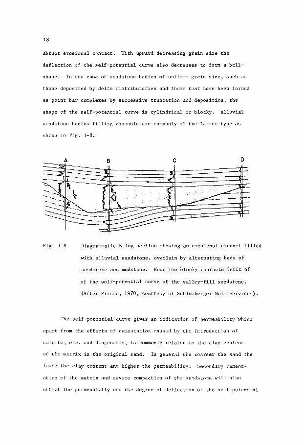
abrup t e r o s i o n a l c o n t a c t . With upward dec reas ing g r a i n s i z e t h e
d e f l e c t i o n of t h e s e l f - p o t e n t i a l curve a l s o dec reases t o form a b e l l -
shape . I n t h e case of s ands tone bod ies of uniform g r a i n s i z e , such as
those depos i t ed by d e l t a d i s t r i b u t a r i e s and those t h a t have been formed
as p o i n t b a r complexes by success ive t r u n c a t i o n and d e p o s i t i o n , t h e
shape of t h e s e l f - p o t e n t i a l curve is c y l i n d r i c a l o r blocky. A l l u v i a l
s ands tone bod ies f i l l i n g channels are commonly of t h e l a t t e r type as
shown i n F ig . 1-8.
C D
Fig . 1-8 Diagrammatic E-log s e c t i o n showing an e r o s i o n a l channel f i l l e d
wi th a l l u v i a l s ands tone , o v e r l a i n by a l t e r n a t i n g beds of
s ands tone and mudstone. Note t h e b locky c h a r a c t e r i s t i c of
of t h e s e l f - p o t e n t i a l curve of t h e v a l l e y - f i l l sands tone .
(Af t e r P i r s o n , 1970, cour t e sy of Schlumberger Well Se rv ices ) .
The s e l f - p o t e n t i a l curve g ives an i n d i c a t i o n of pe rmeab i l i t y which
a p a r t from t h e e f f e c t s of cementa t ion caused by t h e i n t r o d u c t i o n of
c a l c i t e , e t c . and d i a g e n e s i s , is commonly r e l a t e d t o t h e c l a y con ten t
of t h e m a t r i x i n t h e o r i g i n a l sand . In g e n e r a l t h e coa r se r t h e sand t h e
lower t h e c l a y con ten t and h i g h e r t h e Pe rmeab i l i t y . Secondary cement-
a t i o n of t h e m a t r i x and s e v e r e compaction of t h e sands tone w i l l a l s o
a f f e c t t h e pe rmeab i l i t y and t h e degree of d e f l e c t i o n of t h e s e l f - p o t e n t i a l

19
curve. Consequently, t h e shape of t h e s e l f - p o t e n t i a l cu rve , a s an
i n d i c a t o r of g r a i n - s i z e g r a d a t i o n , must b e used w i t h cau t ion .
An example of t h e r e l a t i o n s h i p commonly o b t a i n i n g between g ra in - s i ze
g rada t ion and t h e shape of t h e s e l f - p o t e n t i a l curve is shown i n F ig . 1-9
which c o n t r a s t s t h e c h a r a c t e r i s t i c s of sands tones of mar ine and a l l u v i a l
o r i g i n s . Lower Cre t ac ious v a l l e y - f i l l sands (VF) of t h e Denver Bas in ,
o v e r l a i n by t h e Huntsman Formation and u n d e r l a i n by t h e "52" Sandstone
and S k u l l Creek Formation, have bo th b locky and be l l - shaped s e l f - p o t e n t i a l
POROSITY MEDIAN GRAIN
.I.. ... , . . . . . . . . . _ _ . 'I: :;)V F1 ;:. . . . . ; . . .
. __ . . . 4 : :;: AJ.F:i
E - L O G S OF
, .05SIZE mm.
c
a
5
A
B
CRETACEOUS MARINE (A) AND RIVER (6) SANDS, NEBRASKA
Fig. 1-9 E-log c h a r a c t e r i s t i c s r e l a t e d t o g r a i n s i z e and p o r o s i t y i n
t h e Lower Cre taceous "52" and v a l l e y - f i l l (VF) sands tones ,
Denver Basin, Nebraska. (Redrawn from H a r m s , 1966).

20
curves which r e f l e c t r e spec t ive ly a uniform g r a i n s i z e and a g rada t ion
from coa r se r below t o f i n e r above.
s i z e t h e r e a l s o appears t o be l i t t l e v a r i a t i o n i n pe rmeab i l i t y , al though
p o r o s i t y inc reases toward t h e base of t he sandstone body.
showing an inc rease of g r a i n s i z e toward t h e base of t h e u n i t both permeab-
i l i t y and po ros i ty i n c r e a s e , a s i nd ica t ed by t h e s e l f - p o t e n t i a l curve. I n
c o n t r a s t t h e “52” sandstone, which o r i g i n a t e d a s a r eg res s ive marine
s h o r e l i n e sand, shows a decrease of p o r o s i t y , permeabi l i ty and g r a i n s i z e
toward t h e base of t h e sandstone body.
In t h e example showing a uniform g r a i n
In t h e example
I n t h i s example t h e main o i l and gas product ion comes from t h e
v a l l e y - f i l l sandstone u n i t s , but some is a l s o obtained from t h e marine
s h o r e l i n e sandstones.
wide and 15 m t h i c k , t r ends north-south and has been t r aced f o r 40 km.
Seven f i e l d s have been loca ted along t h i s t rend where t h e axes of north-
-west-plunging a n t i c l i n e s c ros s t h e t rend of t h e anc ien t va l l ey .
The main v a l l e y - f i l l u n i t , which i s above 450 km
Fig. 1-10 S e l f - p o t e n t i a l curves of e l e c t r i c l o g s , and general ized
s e c t i o n s of p o i n t b a r and channel f i l l d e p o s i t s , showing
bel l -shape and cylinder-shape c h a r a c t e r i s t i c s of t h e log
and t h e i r r e l a t i o n s h i p t o a l l u v i a l and d e l t a i c po in t b a r
and c h a n n e l - f i l l depos i t s . Arrow i n d i c a t e s d i r e c t i o n of
growth of p o i n t b a r . A - Upper Cretaceous Tuscaloosa
Sandstone, Wisner F i e l d , Louisiana. B - Oligocene 19B
Sandstone, Seel igson F i e l d , Texas. C - Lower Cretaceous
Blairmore Sandstone, Carbon F i e l d , A lbe r t a . D - Upper
Cretaceous Tuscaloosa “4” Sandstone, L i t t l e Creek F i e l d ,
Miss i s s ipp i .
F i e l d , Louisiana.
Club F i e l d , Louis iana.
E - Miocene “MI’ Sandstone, West Lake Ver re t
F - Miocene ” S ” Sandstone, De l t a Duck

21
RIVER DEPOSITS ALLUVIAL A N D DELTA DISTRIBUTARY
c W Lu
SP LL
0 -+
100 POINT BAR DEPOSll
ro
C H A N N E L F I L L DEPOSIT

22
Other examples of t h e c h a r a c t e r i s t i c s of E-log s e l f - p o t e n t i a l
curves of r i v e r p o i n t b a r and channel d e p o s i t s a r e shown i n Fig. 1-10.
The upper t h r e e examples are as fol lows:
Sandstone, Wisner F i e l d , Louis iana; B - Oligocene 19B Sandstone, Seel igson
F i e l d , Texas; and C - Lower Cretaceous Blairmore Sandstone, Carbon F i e l d ,
A lbe r t a . A l l show t h e t y p i c a l bel l -shape c h a r a c t e r i s t i c of a l l u v i a l
sandstone grading from c o a r s e r a t t h e base t o f i n e r a t t h e top. These
sandstones are i n t e r p r e t e d as having o r i g i n a l l y been p o i n t b a r d e p o s i t s .
The lower t h r e e examples have a blocky o r c y l i n d r i c a l shape c h a r a c t e r i s t i c
of sand bod ies of uniform g r a i n s i z e , o r of a sequence of success ive ly
t runca ted graded beds. They inc lude t h e fol lowing: D - Upper Cretaceous
Tuscaloosa "Q" Sandstone, L i t t l e Creek F i e l d , M i s s i s s i p p i ; E - Miocene "M"
Sandstone, West Lake Verret F i e l d , Louis iana; and F - Miocene "S" Sandstone,
Delta Duck Club F i e l d , Louis iana. These examples a r e considered t o have
been d e l t a d i s t r i b u t a r y sands . The paleogeographic d i s t i n c t i o n made between
t h e upper and lower examples is somewhat a r b i t r a r y .
sand i n t h e middle t o upper reaches of a r i v e r system shows d i s t i n c t g r a i n
g r a d a t i o n of t h e p o i n t b a r t ype , whereas sand i n t h e lower r eaches ,
p a r t i c u l a r l y i n d e l t a d i s t r i b u t a r i e s , shows much less g rada t ion and
comonly has a f a i r l y uniform g r a i n s i z e .
A - Upper Cretaceous Tuscaloosa
I n g e n e r a l , a l l u v i a l
K r a f t , Sheridan and Maisano (1971, p. 671-672) show another example
of bel l -shaped s e l f - p o t e n t i a l curves .
channel sands i n t h e Lower Cretaceous Potomac Group i n Delaware (Fig. 1-11).
They s ta te , " S p o l j a r i c (1967) p re sen ted a d e t a i l e d a n a l y s i s of Potomac
channel sands (Fig. 12) . A sand i s o l i t h contour map of one of t h e
meandering Potomac sand u n i t s r e v e a l s t h a t t h i s Lower Cretaceous nonmarine
sequence might w e l l i nco rpora t e cond i t ions s u i t a b l e f o r petroleum entrap-
ment, p a r t i c u l a r l y in t hose areas where t h e Potomac Group sands and t h e i r
equ iva len t s are more deeply bu r i ed i n t h e Baltimore Canyon trough. I n
These are of meandering r i v e r

23
SP R
F i g . 1-11 E-log of s e c t i o n through stream c h a n n e l s a n d s t o n e s ( s t i p p l e d )
and f l o o d p l a i n d e p o s i t s of s i l t s t o n e and mudstone, i n t h e
Lower C r e t a c e o u s Potomac Group of Delaware.
shaped E-log c h a r a c t e r of t h e c h a n n e l s a n d s t o n e s .
from K r a f t , S h e r i d a n and Maisano, 1971, a f t e r S p o l j a r i c , 1967).
Note t h e b e l l -
(Redrawn
s i t u a t i o n s such as b r a i d e d stream and f l o o d p l a i n areas where t h e Potomac
s a n d s compr ise up t o 50 p e r c e n t of che t o t a l sequence , i t i s u n l i k e l y t h a t
s e p a r a t e d i s t i n c t t r a p s would h a v e formed. Hosrever, where l a t e r a l f a c i e s
changes o c c u r i n Arundel t y p e p a l u d a l o r backswamp l i t h o l o g i e s , and sands
c o n s t i t u t e a p p r o x i m a t e l y 20 p e r c e n t of t h e t o t a l s e c t i o n , a d i s t i n c t
s e p a r a t i o n of sand b o d i e s is more l i k e l y , w i t h updip en t rapment p o s s i b i l i t i e s
i n meandering c h a n n e l sands".
Compaction
Some of t h e problems i n v o l v i n g d i f f e r e n t i a l compaction and i n t e r -
p r e t a t i o n of t h e g e n e s i s of s a n d s t o n e b o d i e s are i l l u s t r a t e d i n F i g s .

24
PEPOSITION I
Fig. 1-12 Diagrammatic sections showing A , erosional channel in
compacted shale and overlying uncompacted clay;
fill sand and flanking clay undergoing compaction;
compacted clay and warped sand body overlain by sediments
draped by differential compaction. (After Pirson, 1970,
courtesy of World Oil).
B, channel-
and C,
1-12 and 1-13. These problems have been pointed out by Rittenhouse (1961),
Oswaldt and Sens (19631, P i r s o n (19701, and Pettijohn, Potter and Siever
(1972). Interpretation of the original geometry of a sandstone body, in
particular whether it formed a bar-shaped mound or filled an erosional
channel, depends on its relationship to the enclosing beds. If some thin
bed or zone within a bed can be chosen as a time-stratigraphic marker, then
certain assumptions can be made regarding differential compaction of the

25
Before Compaction
Surface of Sediment - - ~ a
~- - ~ ~ ~ ~ _. ~ ~ -. . ~ ~ ~ ~ SIDERITE::
-++-&FIXED SUBSTRATUM-~+L+&&
After Compaction
a
Fig. 1-13 Cross-sections showing distortion of a sand body (lower)
resulting from compaction of a channel sand (above).
(Modified by Pettijohn, Potter and Siever, 1972, after
Dupuy, Oswaldt and Sens, 1963) .
sandstone body and its enclosing strata.
then interpretation is likely to be equivocal. In all cases, the use of a
marker implies certain assumptions as to its configuration at the time of
deposition. Commonly, it is assumed that a marker was a fairly flat surface,
possibly with minor undulations but with very little warping or tilting.
These tacit assumptions can in some cases be misleading. In particular, it
is obvious that the choice of a marker either above or below a linear
sandstone body can lead to quite different interpretations. In the former
case it may be concluded that the sandstone body was originally a channel-
If such a marker is not available,

26
- f i l l d e p o s i t , whereas i n t h e l a t t e r case t h e sands tone body may r e p r e s e n t
a sand "build-up' ' such as a b a r o r b a r r i e r i s l a n d ,
e i t h e r i n t e r p r e t a t i o n , i n a s s o c i a t i o n wi th t h e i n f e r r e d pa leogeographic t r e n d s ,
w i l l have a b e a r i n g on t h e d i r e c t i o n i n which a sands tone t r e n d i s ex t r a -
po la t ed .
The i m p l i c a t i o n of
Ancient Sand Bodies
F l u v i a t i l e sed iments a r e known w i t h i n a l l sequences from t h e
Precambrian System t o t h e Quaternary System. But o i l and gas accumul-
a t i o n s i n f l u v i a t i l e sed iments are known on ly i n Devonian and younger rocks .
Some of t h e known examples of a n c i e n t f l u v i a t i l e sed iments have been
demonstrated t o b e channel sands . The c r i t e r i a f o r such r e c o g n i t i o n a r e
mainly geometry of t h e sands tone body, sequences o f g r a i n g r a d a t i o n , and
sed imentary s t r u c t u r e s as i n d i c a t e d by d r i l l - h o l e and ou tc rop d a t a . The
p resence of c e r t a i n s h e l l s , commonly f resh-water gas t ropods and b i v a l v e s ,
and of abundant carbonized wood fragments i s probably i n d i c a t i v e of a
non-marine o r i g i n , a l though bo th can be t r a n s p o r t e d t o an e s t u a r i n e o r
c o a s t a l sand environment. P l a n t m a t t e r is a l s o known t o be f a i r l y abundant
i n some deep-water d e p o s i t s such as t h e f a n formed by t u r b i d i t y c u r r e n t s
sweeping down t h e submarine canyon of t h e Congo R ive r (Shepard, 1965).
Composition and s o r t i n g a r e n o t d e f i n i t i v e of d e p o s i t i o n a l environ-
ment, a l though i n g e n e r a l , poor ly s o r t e d sands tones t h a t are k a o l i n i t i c
and q u a r t z o s e , bu t w i th a f a i r l y l a r g e percentage of l i t h i c f ragments ,
a r e l i k e l y t o b e of f l u v i a t i l e o r i g i n , formed e i t h e r a s channel sands i n
a r i v e r system o r a s b ra ided stream d e p o s i t s on an a l l u v i a l f an . F l u v i a t i l e
s ands depos i t ed by d e l t a d i s t r i b u t a r i e s a r e a l s o qua r t zose , b u t g e n e r a l l y
f ine -g ra ined , w e l l s o r t e d , and n o t r e a d i l y d i s t i n g u i s h e d by l i t h o l o g y from
marine s h o r e l i n e sands .
The o l d e s t known f l u v i a t i l e d e p o s i t s , i nc lud ing t h e Torr idonian

27
Formation of S c o t l a n d , are P r o t e r o z o i c . The o l d e s t known f l u v i a t i l e
d e p o s i t s of t h e Cambrian System are molasse s e d i m e n t s of t h e w e s t e r n
S i b e r i a n P l a t f o r m .
d e l i n e a t e d f o r d i s t a n c e s of s e v e r a l m i l e s a r e t h e O r d o v i c i a n P u l a s k i and
F a y e t t v i l l e Channels of Tennessee.
The o l d e s t known c h a n n e l sand d e p o s i t s t h a t have been
P u l a s k i and F a y e t t v i l l e Channels , Tennessee
The Upper O r d o v i c i a n (Richmondian) Pulaslci Channel and F a y e t t v i l l e
7,
0-1 10 MILES
ORDOVICIAN PULASKI CHANNEL
TENNESSEE
Fig. 1-14 Map and s e c t i o n s of t h e O r d o v i c i a n P u l a s k i and F a y e t t e v i l l e
r i v e r c h a n n e l s i n Giles and L i n c o l n c o u n t i e s , Tennessee.
(Redrawn from Wilson, 1948).
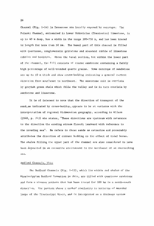
Channel (F ig . 1-14) i n Tennessee are l o c a l l y exposed by ou tc rops . The
P u l a s k i Channel, en t renched i n Lower Ordovic ian (Trentonian) l imes tone , i s
up t o 40 m deep , h a s a wid th i n t h e range 300-750 m, and has been t r a c e d
i n l e n g t h f o r more than 50 km. The b a s a l p a r t of t h i s channel i s f i l l e d
wi th q u a r t z o s e , conglomera t ic g r i t s t o n e and abundant rubb le of l imes tone
cobbles and bou lde r s . Above t h e b a s a l s e c t i o n , bu t w i t h i n t h e lower p a r t
of t h e channe l , t h e f i l l c o n s i s t s of coa r se sands tone con ta in ing a f a i r l y
h igh pe rcen tage of well-rounded q u a r t z g r a i n s . Some outcrops of sands tone
a r e up t o 10 m t h i c k and show cross-bedding i n d i c a t i n g a g e n e r a l c u r r e n t
d i r e c t i o n from s o u t h e a s t t o nor thwes t . The sands tone u n i t is o v e r l a i n
by g rey i sh green s h a l e which f i l l s t h e v a l l e y and i s i n t u r n o v e r l a i n by
sands tone and l imes tone .
I t i s of i n t e r e s t t o n o t e t h a t t h e d i r e c t i o n of t r a n s p o r t of t h e
s a n d , a s i n d i c a t e d by c ross -beddinp ,appears t o be a t v a r i a n c e wi th t h e
i n t e r p r e t a t i o n of r e g i o n a l Richmondian geography, accord ing t o Wilson
0 9 4 8 , p. 7 4 3 ) who s t a t e s , "These d i r e c t i o n s are upstream w i t h r e f e r e n c e
t o t h e d i r e c t i o n t h e e rod ing stream flowed; landward w i t h r e f e r e n c e t o
t h e invading sea".
a t t r i b u t e s t h e d i r e c t i o n of c u r r e n t bedding t o t h e e f f e c t of t i d a l bo res .
The s h a l e s f i l l i n g t h e upper p a r t of t h e channel a r e a l s o cons idered t o have
been depos i t ed i n an e s t u a r i n e environment t o t h e nor thwes t of an encroaching
sea.
H e r e f e r s t o t h e s e sands as e s t u a r i n e and presumably
Bedford Channels, Ohio
The Bedford Channels (F ig . 1-15), which l i e w i t h i n r ed s h a l e s of t h e
Miss i s s ipp ian Bedford Formation i n Ohio, a r e f i l l e d wi th q u a r t z o s e sands tone
and form a s inuous p a t t e r n t h a t has been t r a c e d f o r 100 km i n a nor th-south
d i r e c t i o n . The p a t t e r n shows a marked s i m i l a r i t y t o p a t t e r n s of meander
loops of t h e M i s s i s s i p p i R ive r , and i s i n t e r p r e t e d as a d ra inage system

29
CHANNEL S A N D S
A- MISSISSIPPI RIVER
6-MISSISSIPPIAN BEDFORD
F O R M A T I O N , OHIO
M I L E S
Fig. 1-15 A - Channels of t h e M i s s i s s i p p i R ive r n e a r Natchez,
M i s s i s s i p p i . Drainage from n o r t h t o sou th . (Redrawn
from F i s k , 1 9 4 4 ) .
B - Channel sands w i t h i n t h e M i s s i s s i p p i a n Bedford Formation
i n n o r t h e r n Ohio. Drainage from n o r t h t o s o u t h . Same
s c a l e a s ( A ) . (Redrawn from Pepper , D e W i t t , and
Demarest, 1 9 5 4 ) .
wi th in t h e Bedford De l t a .
channels c o n s t i t u t e s t h e b a s a l u n i t of t h e ove r ly ing Miss i s s ipp ian Berea
Sandstone. Th i s b a s a l u n i t of sands tone ocdupies channels c u t i n t o t h e
Bedford Formation and a l s o l o c a l l y i n t o t h e under ly ing Cleveland Member
of t h e Upper Devonian Ohio Shale .
A s l i g h t l y younger system of sands tone - f i l l ed
Nany o f t h e s e channels communly have a

30
width i n t h e range 300-600 m , and depths of up t o 60 m. O i l and gas
p roduc t ion has been ob ta ined from t h e s e younger channels (F ig . 1-28),
i nc lud ing t h e Cabin Creek Channel. I n t h e Cabin Creek F i e l d (F ig . 1-27)
gas is ob ta ined from f r i a b l e qua r t zose sands tone o v e r l a i n by a cap rock of
s i l i c i f i e d q u a r t z i t i c sands tone . Pepper, D e W i t t and Demarest (1954) are
of t h e op in ion t h a t s i l i c i f i c a t i o n of t h e qua r t zose sands tone r e s u l t e d
from downward cementa t ion of t h e s a n d - f i l l e d channel .
COAL N 0 . 7
A
L 200 B 0 1
O-' - K M MILE
PENNSYLVANIAN CHANNEL SAND,
ILLINOIS
0
lOOln
F ig . 1-16 A - Cross-sec t ion of Anvil Rock Sandstone, a Pennsylvanian
channel sand , i n t h e I l l i n o i s Basin. Coal seam Yo. 7
is t aken as a datum. (Redrawn from P o t t e r , 1963).
B - R e i n t e r p r e t a t i o n of (A) t o show p o s s i b l e concordance of
e l e v a t i o n of remnants of r i v e r v a l l e y terraces.

31
Anvil Rock Channel, I l l i n o i s
The Pennsylvanian Anvil Rock Sandstone of t h e I l l i n o i s Basin f i l l s
channels formed by streams which meandered down a paleoslope and cu t i n t o
d e l t a i c shee t - l i ke sands (Hopkins, 1958; P o t t e r and Simon, 1961). The
s e c t i o n i l l u s t r a t e d by Fig. 1-16 shows one channel t o have a width of more
than 5 km and a th i ckness of n e a r l y 60 m.
A s mentioned e a r l i e r , i n t h e s e c t i o n on compaction of channel sands,
t he choice of a datum may i n i t s e l f have i m p l i c i t assumptions a s t o the
genesis and o r i g i n a l geometry of a sandstone body. I n cons t ruc t ing the
shape of a l i n e a r sandstone body t h a t may have o r i g i n a t e d a s a channe l - f i l l
sand, a datum can be taken below, a t t h e base , a t t h e top, o r above t h e
sandstone body. I f t he sandstone body was, i n f a c t , deposi ted a s a channel
sand, then a datum taken on some s t r a t i g r a p h i c marker below t h e body may not
be meaningful, a s t h e marker would commonly be deformed by compaction
occurr ing during t h e growth of t h e ove r ly ing sand body.
sand body d i r e c t l y overlying an unconformity, a marker beldw t h e sand body
may have been t i l t e d o r otherwise deformed p r i o r t o t h e depos i t i on of t h e
sand. S i m i l a r l y , i f t h e sand body was o r i g i n a l l y a channel sand, a datum
taken a t t h e base of t h e body o r channel would obviously r e s u l t i n an
erroneous r econs t ruc t ion . A datum taken a t t h e top of t h e sand body w i l l
g ive a reasonable r econs t ruc t ion of t he c ros s - sec t iona l shape of t h e
channel sand a t t h e time i t was i n i t i a l l y bu r i ed , provided the su r face was
nea r ly f l a t .
s t r a t i g r a p h i c marker above, bu t c l o s e t o t h e upper s u r f a c e of t h e sand body
w i l l r e s u l t i n t h e b e s t r econs t ruc t ion and may f a c i l i t a t e t h e i n t e r p r e t a t i o n
of s t r u c t u r a l l y high p a r t s of t he sandstone u n i t formed a s e r o s i o n a l
remnants of r i v e r v a l l e y t e r r a c e s , and buried a s sand h i l l s . Provided they
have c l o s u r e , t hese "highs" can form r e s e r v o i r s f o r o i l and gas such a s the
B e l l s h i l l Lake, Hughenden, and Al l i ance f i e l d s i n t h e Lower Cretaceous
E l l e r s l i e Sandstone of Alberta (Figs. 1-41, 1-42, 1-43).
In t h e case of a
But t h i s may seldom be t h e case. A datum taken on some

32
SCALE
0- 6 MILES
Fig. 1-17 Map showing t h e conf igu ra t ion of a channel sand wi th in t h e
No . 5 coa l seam of t h e Pennsylvanian Carbondale Formation i n
sou theas t e rn I l l i n o i s . Medium coa l is more than 5 f e e t
(1.5m) t h i c k . (Wanless, 1970, a f t e r T r e s c o t t , 1964, and
V a i l , 1965).

33
Carbondale Channel, I l l i n o i s
The Carbondale Channel of sou theas t e rn I l l i n o i s is an i n t e r e s t i n g
example of an anc ien t meandering stream t h a t flowed through a f l a t t e r r a i n
of marsh and swamp. Within t h e Pennsylvanian Carbondale Formation t h e No. 5
coal zone con ta ins a sandstone body t h a t o r i g i n a t e d as a c h a n n e l - f i l l sand.
Reconstructed i n cons ide rab le d e t a i l (Fig. 1-17) from subsu r face d a t a , t he
channel appears t o have been p a r t of t h e drainage system of a f l a t , marshy
land t h a t probably formed p a r t of a d e l t a complex.
shown t o be approximately 2 km i n wid th , can be t r a c e d f o r 100 km. With
r e fe rence t o t h i s channel Wanless (1970, p. 288) says "Because t h e sandstone
does n o t extend s t r a t i g r a p h i c a l l y h ighe r than t h e c o a l , i t does n o t seem
l i k e l y t h a t t h e c o a l w a s depos i t ed and s w s e q u e n t l y c u t ou t by e ros ion ,
b u t i n s t e a d t h e r i v e r w a s d i scha rg ing through the winding channel while
t he c o a l w a s forming i n t h e ad jacen t swamp". It i s of i n t e r e s t t o no te
t h a t t h e t h i c k e r c o a l seams are loca ted i n a 10 - 15 km-wide b e l t along
which
which vege ta t ion accumulated more r a p i d l y than on t h e ad jacen t uplands.
The channel , which i s
t h e channel meanders, sugges t ing t h a t t h i s b e l t formed a v a l l e y i n
Fig. 1-18 i l l u s t r a t e s ano the r example of a Pennsylvanian channel
sandstone i n t h e I l l i n o i s Basin. This sandstone body ranges up t o 25 m
t h i c k and has been t r a c e d alongameandering course f o r more than 30 km.
The p a t t e r n of t h e isopach map i s t y p i c a l of p a t t e r n s r e s u l t i n g from t h e
superimposi t ion of anastomosing t r i b u t a r i e s d ra in ing i n t o t h e main
channel , and probably i n d i c a t e s a d ra inage p a t t e r n on a f a i r l y f l a t
t e r r a i n .
Another example of a channel c u t i n t o a coal-bearing s e c t i o n
(Fig. 1-19) is given by Wier (1953). This channel , f i l l e d wi th cross-
-bedded sandstone, is w i t h i n t h e Pennsylvanian Petersburgh Formation of
t h e I l l i n o i s Basin.
a width i n excess of 2 km, has been t r a c e d f o r s e v e r a l k i lome te r s i n an
The channel , which has a th i ckness of up t o 20 m and

34
0 0
w 1-20
0 21-80
0 2 L 6 8km
0 I 2 3 L 5miles
I I I I I I I I
F i g . 1-18 I s o p a c h map of a P e n n s y l v a n i a n s a n d s t o n e i n t h e I l l i n o i s
B a s i n , showing t h i c k n e s s i n f e e t of a meandering body.
(Modified by P e t t i j o h n , P o t t e r and S i e v e r , 1972, a f t e r
P o t t e r , 1963).
e a s t - w e s t d i r e c t i o n . The a t t i t u d e of t h e c ross -bedding i n d i c a t e s t h a t
t h e c u r r e n t f lowed t o t h e w e s t . The c h a n n e l i s b e l i e v e d t o have been
formed by a d e l t a d i s t r i b u t a r y t h a t f lowed through a low-lying c o a s t a l
marsh. The c h a n n e l is o v e r l a i n by s i l t s t o n e a n d , of p a r t i c u l a r i n t e r e s t ,
by l e n t i c u l a r beds of l i m e s t o n e . T h i s s t r a t i g r a p h i c s u c c e s s i o n s u g g e s t s
t h a t t h e d e p o s i t i o n a l environment may have been s imilar t o t h a t s e e n today
i n p a r t s of F l o r i d a , as d e s c r i b e d by Spackman, S c h o l l , and T a f t (1964).

35
V
F E E T
K M
M I L E
SANDSTONE CHANNEL IN COAL SEAM,
P E N N SYLVAN I A N PETE RSBU RG H FOR M A TI 0 N, I NDI A N A
0
25 m
Fig. 1-19 Cross-bedded sandstone channel formed i n a washout, i n
Coal V , Pennsylvanian Petersburgh Formation, I l l i n o i s
Basin, P ike County, Indiana. (Redrawn from Wier, 1953).
u 1 K M M I L L S
300 i too8
CROSS-SECTION OF CHANNEL SANDSTONES,
P E N N SYLVAN IAN G R A H A M FO R M AT I 0 N,
BRAZOS BASIN, TEXAS
Fig. 1-20 S t r a t i g r a p h i c r e l a t i o n s h i p s of. unconformable channel
sandstones w i t h i n t h e Pennsylvanian Graham Formation,
Cisco Group, Brazos Basin, Texas. (Redrawn from Lee, 1938).
36
Graham Channels, Texas
Sandstone-f i l led channels w i t h i n . t h e Graham Formation of t h e Upper
Pennsylvanian Cisco Group i n t h e Brazos Basin, Texas, have been descr ibed
i n d e t a i l by Lee (1938). The r e l a t i o n s h i p s of i n d i v i d u a l , superimposed
channels is i l l u s t r a t e d i n Fig. 1-20 which shows ove r ly ing channels
c u t t i n g i n t o those below. Ind iv idua l channels have widths of up t o 15 km
and depths up t o 60 m. The sandstones f i l l i n g these channels a r e quartzose,
we l l - so r t ed , cross-bedded, and l o c a l l y con ta in abundant fragments of
carbonized p l a n t remains.
The channels , thought t o have been cu t by a system of anastomosing
d i s t r i b u t a r i e s , l i e w i t h i n beds of l imestone and s h a l e deposi ted i n
n e r i t i c t o p a r a l i c environments t h a t probably bordered an ex tens ive and
subsiding c o a s t a l p l a i n .
B a r t l e s v i l l e Channels, Kansas
Linear sandstone bodies w i t h i n t h e Lower Pennsylvanian Cherokee
Shale of Kansas and Oklahoma have been va r ious ly i n t e r p r e t e d . Rees
(1972, p. 176) s a y s , "Many workers have s t u d i e d t h e " shoes t r ing sands"
of sou theas t e rn Kansas and no r theas t e rn Oklahoma. They have been
descr ibed a s off-shore b a r s , b a r r i e r - i s l a n d b a r s , beach r i d g e s , channel
s ands , dune sands, and point-bar sands. The wide diversence of opinion
stems l a r g e l y from d i f f e r e n t i n t e r p r e t a t i o n s placed on the bed geometry."
Fig. 1-21 i l l u s t r a t e s t h e t r ends of two such o i l -bea r ing sandstone
bodies i n t h e Chanute F i e l d of Kansas. Reconstruct ion of t h e o r i g i n a l
geometry, by D i l l a r d , Oak, and B a s s (1941), shows them as o f f shore ba r s
w i t h f l a t bases ; although i t was noted by these au tho r s t h a t t h e cross-
-bedded sandstone bodies o v e r l i e a coa l seam. Previous s t u d i e s by Lewis
(1929) and l a t e r work by Rees (1972) supported t h e view t h a t t he Bart les-
v i l l e "shoestr ing sands" a r e f l u v i a t i l e i n o r i g i n and t h a t they were
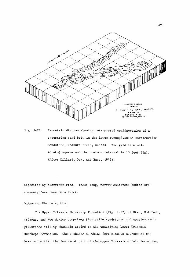
37
Fig. 1-21 Isometric diagram showing interpreted configuration of a
shoestring sand body in the Lower Pennsylvanian Bartlesville
Sandstone, Chanute Field, Kansas. The grid is k mile
(0.4km) square and the contour interval is 10 feet (3m).
(After Dillard, Oak, and Bass, 1941).
deposited by distributaries. These long, narrow sandstone bodies are
commonly less than 30 m thick.
Shinarump Channels, Utah
The Upper Triassic Shinarump Formation (Fig. 1-22) of Utah, Colorado,
Arizona, and New Mexico comprises fluviatile sandstones and conglomeratic
gritstones filling channels eroded in the underlying Lower Triassic
Moenkopi Formation. These channels, which form sinuous courses at the
base and within the lowermost part of the Upper Triassic Chinle Formation,

38
-.. . , . > , ' . C H I N L E
MOENROPI o F E E T r0
L ' o o I,,,. 1 0 1
MILE KM
SANDSTONE CHANNELS I N TRIASSIC BEDS,
FOUR CORNERS AREA, U.S.A.
Fig. 1-22 Diagrammatic c r o s s s e c t i o n showing sandstone channels a t
t h e base of and w i t h i n t h e Triassic Chinle Formation. The
b a s a l channels , named t h e Shinarump Formation, c u t i n t o t h e
Ea r ly T r i a s s i c Moenkopi Formation. These f o r n a t i o n s crop
o u t i n t h e Four Corners area (Utah, Colorado, Arizona and
New Mexico) where t h e Shinarump con ta ins uranium-vanadium
mine ra l i za t ion . Contour i n t e r v a l i n f e e t (1' = 0.305m).
(Redrawn from Stokes, 1961).
are commonly less than 30 m deep.
have been p o i n t b a r s , s p i l l - o v e r b a r s and a s s o c i a t e d sand bodies deposi ted
by a meandering r i v e r t h a t developed an ex tens ive system i n t h e Four Corners
region.
i n t h e s e sandstones.
p a r t s of t h e s e sandstones are mined l o c a l l y f o r uranium-vanadium mine ra l s
depos i t ed by s o l u t i o n s moving along the more permeable courses of t he
channels .
The channel saQdstones are thought t o
Carbonized p l a n t remains and cross-bedding are common f e a t u r e s
Of p a r t i c u l a r i n t e r e s t i s t h e fa.ct t h a t t h e lower

39
J a c k p i l e Channel, New Mexico
The J a c k p i l e Sandstone (F ig . 1-23), which l i es w i t h i n the uppermost
p a r t of t h e Upper J u r a s s i c Morrison Formation i n New Mexico, f i l l s a
no r theas t - t r end ing channel t h a t is up t o 20 km wide , 60 m deep , and more
than 50 km long. The n o r t h e a s t e r n ex tens ion of t h i s channel s p l i t s i n t o
t h r e e s e p a r a t e channels c u t by d i s t r i b u t a r i e s which flowed t o t h e n o r t h e a s t .
The J a c k p i l e , which a l s o f i l l s t h e s e s u b s i d i a r y channels , v a r i e s i n comp-
o s i t i o n from ca lc i te -cemented f e l d s p a t h i c sands tone a t t h e base t o kao-
l i n i t i c , qua r t zose sands tone a t t h e top . This v a r i a t i o n i s thought by
Fig. 1-23 Genera l ized i s o m e t r i c b lock diagram showing t h e conf igu ra t ion
of t h e a l l u v i a l J a c k p i l e Sandstone, t h e uppermost member
of t h e Upper J u r a s s i c Morrison Formation, New Mexico.
(Af t e r Schlee and Moench, 1961).

40
MILLI- GRAIN SIZE
I 1 I 0 8 I;O(M E T E R s 0.2 0.4 06
n LL 0
Q m
W
I ( 2 READINGS) & 150 W ( F E E T )
m
n
Fig. 1-24 V e r t i c a l g r a d a t i o n i n g r a i n - s i z e w i t h i n t h e a l l u v i a l Upper
J u r a s s i c J a c k p i l e Sands tone , New Mexico. (Af te r Schlee
and Moench, 1961).
Schlee and Moench (1961) t o b e t h e r e s u l t of weather ing p r i o r t o t h e
d e p o s i t i o n of t h e ove r ly ing Lower Cre taceous Dakota sed iments . These
channel sands tones are modera te ly w e l l s o r t e d , cross-bedded, f i n e t o
med im-gra ined , and show an o v e r a l l f i n i n g from bottom t o top (F ig . 1-24)
The J a c k p i l e is an impor tan t h o s t rock f o r uranium mine ra l s mined i n t h e
Laguna a r e a , w e s t of Albuquerque, New Mexico.
O i l and Gas F i e l d s
F l u v i a t i l e sands tones have been recorded i n a l l Systems from
P r o t e r o z o i c t o Quaternary i n c l u s i v e , bu t o i l and gas accumulations a r e
n o t known i n f l u v i a t i l e sands tones o l d e r t han t h e Devonian.
twenty-eight examples g iven i n t h i s book are as fo l lows:
H i s s i s s i p p i a n - 3 , Pennsylvanian -5, Permian -1, T r i a s s i c -1, J u r a s s i c -1,
Cretaceous - 1 2 , and T e r t i a r y - 3 . Although i t would appear from t h i s l i m i t e d
sampling t h a t t h e Cre taceous occupies a s p e c i a l p l a c e favour ing t h e
accumulation of hydrocarbons i n r i v e r sed iments , i t must be poin ted out
The a<es of
Devonian -2,

41
t h a t t h e examples g iven are from t h e A l b e r t a , Powder B ive r , and Denver
bas ins where t h e Mesozoic has been e x t e n s i v e l y d r i l l e d . There is no
b a s i s f o r assuming, on a world-wide b a s i s , t h a t f l u v i a t i l e d e p o s i t s w e r e
more abundant i n one Pe r iod than i n ano the r .
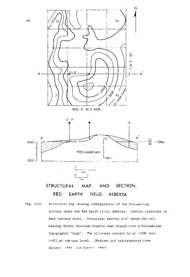
Red Earth O i l F i e l d , A l b e r t a
In the Red Ea r th F i e l d (F ig . 1-25) of no r the rn A l b e r t a o i l i s
produced from t h e b a s a l Pa leozo ic G r a n i t e Wash which l i es on t h e eroded
Precambrian s u r f a c e . The age of t h e Gran i t e Wash has n o t been determined;
bu t i t i s o v e r l a i n by a n h y d r i t i c and d o l o m i t i c ca rbona te s o f t h e Middle
Devonian Muskeg Formation, and is probably Ea r ly Devonian. The Gran i t e
Wash i s mainly a f i n e t o ve ry c o a r s e , poor ly s o r t e d qua r t zose and f e l d s -
p a t h i c sands tone , of sub-rounded t o angu la r g r a i n s , b u t c o n t a i n s t h i n
beds of g reen i sh s h a l e having a waxy appearance. Lying on t h e basement
topography i t t h i n s over t h e "highs" and th i ckens t o 30 m o f more i n t h e
"lows". Maximum t h i c k n e s s of t h e n e t porous sands tone is 29 m , and t h e
average t h i c k n e s s of t h e n e t producing sands tone i s 5m. Pe rmeab i l i t y i s
good, be ing i n t h e range 120-120 m i l l i d a r c y s v e r t i c a l l y , and 300-450
m i l l i d a r c y s h o r i z o n t a l l y . P o r o s i t y averages 14%.
The o i l recovered has a g r a v i t y of 38OA.P.I., a p a r a f f i n base , and
a su lphur con ten t of 0.3%. The e s t ima ted amount of o i l i n p l ace w i t h i n
two separa te pools is 110 m i l l i o n b a r r e l s of which only 22 m i l l i o n b a r r e l s
(3.5 m i l l i o n cub ic met res ) a r e l i k e l y t o b e recovered
f i e l d ' s n a t u r a l wa te r d r i v e .
by means of t h e
The t e r m ' g r a n i t e wash' imp l i e s a sandy sediment , probably of qua r t -
zose and f e l d s p a t h i c composi t ion , de r ived and t r a n s p o r t e d from g r a n i t i c
and g n e i s s i c t e r r a i n . Flawn (1965, p. 885) s a y s , " I f i t i s n o t a t r anspor t ed
sediment and i t i s no t "washed'', t h e terms weathered g r a n i t e o r a l t e r e d
g r a n i t e o r decomposed g r a n i t e are more accu ra t e" . F i l l i n g topographic
42
A -
RGE. 8 W. 5 MER
I - 3000'
- 3300'
12 17
_ _ _ - 0 - 2986
PRECAMBRIAN
0 I
MILE
O U ' KM
STRUCTURAL MAP AND SECTION,
RED EARTH FIELD, ALBERTA
Fig . 1-25 S t r u c t u r a l map showing c o n f i g u r a t i o n of t he Precambrian
s u r f a c e under t h e Red Ea r th Fi.eld, A lbe r t a .
f e e t sub-sea l e v e l . S t r u c t u r a l s e c t i o n A-A' shows t h e o i l -
bea r ing Middle Devonian Gran i t e Wash draped ove r a Precambrian
topographic ' h igh ' . The o i l -wa te r c o n t a c t is a t -2986 f e e t
(-911 m) sub-sea l e v e l .
m i l t n n i Q c I c 1 3 n ~ i a s l n t n V i o ~ c \
Contour i n t e r v a l s i n
(Redrawn and r e i n t e r p r e t e d from

43
depres s ions , t h e poor ly s o r t e d Gran i t e Wash i n t h e Red Ea r th F i e l d w a s ev i -
den t ly no t moved very f a r from i ts a r e a of o r i g i n and was appa ren t ly
t r anspor t ed by sur face-water which r an o f f t h e s l o p e s and formed a
dra inage system a long v a l l e y s eroded i n t h e Precambrian basement. A s
t h e v a l l e y s f i l l e d wi th g r a n i t i c d e b r i s , t h e basement h i l l s were even tua l ly
bu r i ed by wedges of Gran i t e Wash swept o u t on a f a i r l y f l a t outwash-plain.
On t h i s s u r f a c e t h e encroaching Muskeg Sea developed a carbonate bank
f r inged by c o a s t a l sabkhas i n which gyps i f e rous d e p o s i t s were formed.
The Gran i t e Wash o r i g i n a l l y cons i s t ed of a l l u v i a l sands and minor
muds, much of which were probably f l u v i a t i l e . L i t t l e is known of t h e
paleogeomorphology of t h i s u n i t , and i t can only b e surmised t h a t
channels may e x i s t which could c o n t a i n accumula t ions of o i l i n s t r u c t u r a l -
- s t r a t i g r a p h i c s i t u a t i o n s r e s u l t i n g from compaction over basement topography,
r eg iona l t i l t i n g of t h e s t ra ta , and wa te r d r i v e .
Music Mountain O i l Pool , Pennsylvania
The Music Mountain O i l Pool (F ig . 1-26) i n McLean County, Pennsylvania
i s i n t h e Upper Devonian S l i v e r v i l l e Sandstone of t h e Canadaway Group.
This sands tone i s q u a r t z o s e , medium t o coarse-gra ined , i n p a r t conglomera t ic ,
and c o n s i s t s of sub-angular t o angul-ar g r a i n s . P o r o s i t y averages 13%, and
pe rmeab i l i t y ranges up t o s e v e r a l hundred m i l l i d a r c y s . Angular c l ays tone
fragments, resembling f ragments of sun-dried c l a y , are con ta ined w i t h i n
t h e sands tone .
In t h e producing a r e a t h e S l i v e r v i l l e Sandstone forms a channel - l ike
body which t r ends nor theas t - southwes t on t h e f l a n k o f an a n t i c l i n e .
sands tone body, which has been t r a c e d f o r more than 6 km, i s 250-300m wide
and up t o 25 m t h i c k .
c o n s i s t s of i n t e rbedded grey s h a l e and f i n e t o coa r se brownish sands tones .
F e t t k e (1941) cons idered t h e group t o be mar ine , and i n t e r p r e t e d t h e
This
The Canadaway Group, of which i t forms a p a r t ,

44
GEOMETRY OF SLIVERVILLE SANDSTONE,
P E N N S Y LVAN I A
F i g . 1-26. I sopach map of S l i v e r v i l l e Sands tone i n t h e Upper Devonian
Canadaway Group, Music Mountain O i l P o o l , McLean County,
Pennsylvania . Contour i n t e r v a l i n f e e t ( 1 ' = 0.305 m).
(Redrawn from F e t t k e , 1941).

45
S l i v e r v i l l e Sandstone as an o f f s h o r e b a r . The n a t u r e of t h e sand ( i n p a r t
coarse-grained and pebbly , c o n s i s t i n g of sub-angular t o angu la r g r a i n s ,
and con ta in ing angular ch ips of c l a y s t o n e resembling f ragments of d r i e d
mud) i n d i c a t e s a f l u v i a t i l e r a t h e r than a wave-washed environment, and
sugges t s t h a t t h e S l i v e r v i l l e sand body w a s p robably a d e l t a - d i s t r i b u t a r y
sand.
The Music Mountain O i l P o o l y i e l d s both o i l and g a s , t h e o i l having
a p a r a f f i n b a s e and a waxy con ten t . It i s of i n t e r e s t t o n o t e , i n t h i s
r e s p e c t , t h a t Hedberg (1968) concluded t h a t waxy o i l s w e r e c h a r a c t e r i s t i c a l l y
der ived from sands tone-sha le sequences of non-marine o r p a r a l i c o r i g i n .
The f i e l d has a gas d r i v e , and du r ing i t s e a r l y h i s t o r y i n i t i a l producing
rates of up t o 500 b a r r e l s of o i l and 15 m i l l i o n cubic f e e t of gas pe r day
were recorded .
Cabin Creek G a s F i e l d , Ohio
Product ion of gas and some l i g h t ( 4 7 O A.P.I.) o i l i n t h e Cabin
Creek Gas F i e l d , Ohio (Fig. 1-27) has been obta ined from t h e Ea r ly Mississ-
i p i a n Berea Sandstone. I n t h e f i e l d area t h e Berea occupies a b road ,
s inuous channel c u t i n t o t h e Miss i s s ipp ian Bedford Formation. This channel
i s 5-6 km wide , up t o 15 m deep, and has been t r a c e d i n t h e sub-sur face
f o r more than 15 km. It appears t o b e p a r t of a d ra inage system t h a t
t rended nor th-south f o r more than 80 km.
I n t h e lower p a r t of t h e channel t h e Berea Sandstone is l i g h t
grey , qua r t zose , and coa r se t o g r i t t y w i t h well-rounded pebbles . The
sand g r a i n s are angu la r . I n t h e upper p a r t of t h e channel t h e sands tone
is f i n e r g r a i n e d , h a r d , and well-cemented by q u a r t z . This q u a r t z i t i c
s ands tone , which has a p o r o s i t y of only 4% compared wi th an average
p o r o s i t y of 16% i n t h e lower sands tone , forms a cap rock f o r t h e gas
conta ined i n t h e sands tone below.

46
B A
A ,- L . . . . . . . . . . . . . . . . . . . . . . . . . . . . . . . . . . . . . . . . . . . . . . . . . . . . . . . . . . . . . . . . . . . . . . . . . . . . . . . . . . . . . . . . . . . . . . . . . . . .
. . . . . . . . . . . . . . . . . . . . . . . .
, . : . . ' --------- :i-_. F E E T 10,000
0 2000 0 1
METRES
ISOPACH A N D S E C T I O N S O F MlSSlSSlPlAN
BEREA SAND, C A B I N CREEK GAS FIELD, OHIO
Fig. 1-27. Isopach map of part of the Mississippian.Berea Sand in the
Cabin Creek gas field, Ohio, showing thickness in feet of the
sandstone body.
quartz sandstone (stippled) and the basal poorly-cemented,
gas-bearing quartz gritstone (solid). (Redrawn from Pepper,
De Witt and Demarest, 1954).
Sections AB and AC show tightly-cemented

47
Gay-Spencer-Richardson Trend, V i r g i n i a
O i l and gas p roduc t ion has been ob ta ined from t h e Ea r ly Miss i s s ipp ian
Berea Sandstone i n t h e Gay-Spencer-Richardson f i e l d s (Fig. 1-28) of wes te rn
Virg in ia .
t rending channel f i l l e d wi th Berea Sandstone. The channel is up t o 5 km
wide and 40 km long i n t h e f i e l d a r e a , and ex tends a f u r t h e r 55 km t o t h e
no r theas t . The sands tone , which i s s i m i l a r i n composition and t e x t u r e t o
the Berea i n t h e Cabin Creek Gas F i e l d of Ohio, is u n d e r l a i n by grey , s i l t y
s h a l e and o v e r l a i n by brown s h a l e con ta in ing abundant carbonized p l a n t
ma t t e r . The c o n t a c t between t h e ove r ly ing s h a l e and t h e Berea is marked
by an abundance of p y r i t e .
These f i e l d s merge w i t h one ano the r a long a nor theas t - southwes t
DISTRIBUTION OF OIL AND GAS PRODUCTION
IN B E R E A SANDSTONE, WEST VIRGINIA
Fig . 1-28. D i s t r i b u t i o n of o i l and gas p roduc t ion i n t h e Ea r ly
M i s s i s s i p p i a n Berea Sandstone, Jackson , Roane, and Calhoun
Count ies , West V i r g i n i a . (Redrawn from d i s t r i b u t i o n of o i l
and gas w e l l s p l o t t e d by Heck, 1941).
48
G a s has been produced a long t h e e n t i r e Gay-Spencer-Richardson t r e n d
which is i n t e r s e c t e d by nor th-south t r end ing f o l d s t r u c t u r e s . Of p a r t i c u l a r
i n t e r e s t is t h e f a c t t h a t t h e Berea i n t h i s l o c a l i t y i s no t water -bear ing ,
and consequent ly t h e o i l accumula t ions are w i t h i n s y n c l i n e s . Although t h e
sands tone is d r y , t h e e a r l y producing w e l l s showed t h a t p r e s s u r e w i t h i n
t h e sands tone w a s c o n s i s t e n t w i th h y d r o s t a t i c p r e s s u r e f o r t h e depth of
measurement. The o i l was f i r s t ob ta ined by gas d r i v e and some e a r l y w e l l s
had i n i t i a l p roduc t ion rates of up t o 750 b a r r e l s of o i l and 10 m i l l i o n
c u b i c f e e t of gas p e r day.
Bethe l Sandstone Trend, Kentucky
Seve ra l o i l and gas f i e l d s i n wes tern Kentucky, i n c l u d i n g t h e
Midland, S t . Cha r l e s , Barns ley , Luzerne, Sharon School, and Elk Creek,
have produced from t h e Upper Miss i s s ipp ian Bethe l Sandstone. The
Bethe l f i l l s a channel (F ig . 1-29) c u t i n t o t h e Middle M i s s i s s i p p i a n
(Meramecian) l imes tones and s h a l e s , and is o v e r l a i n by Upper Miss i s s ipp ian
(Ches t e r i an ) l imes tones . The channel , which i s 3 km wide, has been t r a c e d
i n t h e subsu r face f o r a d i s t a n c e of more than 160 km southwes t from where
i t c rops o u t . Toward t h e southwes tern l i m i t s t o which i t h a s been t r a c e d
t h e channel branches and c o n t a i n s s e v e r a l o i l and gas accumula t ions i n
s t r u c t u r a l - s t r a t i g r a p h i c t r a p s , i nc lud ing Midland Gas F i e l d . S i m i l a r
types of t r a p s con ta in ing o i l a r e found i n s a n d s t o n e - f i l l e d d i s t r i b u t a r y
channels c u t t i n g l imes tone and s h a l y beds i n a d e l t a i c sequence of t h e
Upper Pennsylvanian t o Lower Permian Cisco Group i n n o r t h - c e n t r a l l e x a s
(Galloway and Brown, 1973). Many of t h e s e a r e commercial o i l f i e l d s .
The Bethe l Sandstone i n t h e Midland f i e l d has a g ross th i ckness of
up t o 75 m and a maximum producing s e c t i o n of 55 m. The mean pe rmeab i l i t y
i s 117 m i l l i d a r c y s and t h e mean p o r o s i t y is 13%. The Midland f i e l d is
es t ima ted t o have o r i g i n a l l y conta ined 163,000 m i l l i o n cub ic f e e t (4,560
m i l l i o n cub ic me t re s ) of r ecove rab le gas averaging 98% methane, and s e v e r a l

49
LIMESTONE SHALE Figure 4 A Pic Bethel erosion channel
LIMESTONE SHALE SANDSTONE CALCAREOUS SANDSTONE AND/ORSHALE
Figure 4 8 Chonnel o t te r Bethel deporitmn ond bockfil l
LIMESTONE SHALE SANDSTONE
Fig. 1-29. Schematic block diagrams showing the stratigraphic relation-
ships of the channel-forming Upper Mississippian Bethel
Sandstone to the overlying Upper Mississippian (Chesterian)
and underlying Middle Mississippian (Xeramecian) sediments,
Kentucky. (After Reynolds and Vincent, 1972).

50
t e n s of m i l l i o n s of b a r r e l s of heavy ( 2 4 0 A . P . I . ) o i l . The volume of gas-
-producing sands tone is es t ima ted t o be 542,000 a c r e - f e e t .
Tyler O i l Fields,Mont*
O i l is produced from t h r e e sands tone members i n t h e lower u n i t of
t h e Lower Pennsylvanian Tyler Formation of c e n t r a l Montana. These sand-
s t o n e members f i l l channels w i t h i n a broad , meandering v a l l e y (F ig . 1-30)
M O N T A N A
. A R E A O F
.A.. ' \I
W Y O M I N G
LOWER TYLER DISTRIBUTION
Fig . 1-30. D i s t r i b u t i o n of channel sands tone members i n t h e lower u n i t
of t h e Lower Pennsylvanian Ty le r Formation, Montana. (After
Kranz le r , 1966).

51
t rending f o r more than 500 km eas tward a c r o s s c e n t r a l Xontana i n t o North
Dakota. This v a l l e y c u t s i n t o l imes tone and s h a l e members of t h e :+ississ-
ipp ian Heath Formation (F ig . 1-31). The lower two sands tone members l i e
on the e r o s i o n a l s u r f a c e ; t h e upper sands tone member, c a l l e d t h e Stensvad
Sand, occupies a s t r a t i g r a p h i c a l l y h i g h e r p o s i t i o n w i t h i n t h e v a l l e y - f i l l
sediments of t h e Lower Ty le r .
The pos t -Miss i ss ippian v a l l e y , i n which t h e Lower Ty le r sediments
N E KEG COULEE IVANHOE STENSVAD s w
A v DATUM 0 TOP OF 0 TYLER 0 4 A'
1 UPPER I TYLER I I
S C A L E S I H F E E T
PAL EOS JRUC TURAL GROSS SECTION KEG COULEE- MANHOE -SJENSVAD
Fig. 1-31. Sec t ion of e r o s i o n a l v a l l e y i n M i s s i s s i p p i a n Heath Formation,
through t h e Keg Coulee, Ivanhoe and Stensvad f i e l d s , showing
s t r a t i g r a p h i c r e l a t i o n s h i p s o f o i l -bea r ing sands tone members
w i t h i n t h e lower u n i t of t h e Lower Pennsylvanian Ty le r
Formation, Montana. (Af t e r Kranz le r , 1966).

52
l i e , has a depth of up t o 100 m and a wid th of up t o 15 km. It is f i l l e d
mainly wi th s i l t s and grey s h a l e s ( con ta in ing abundant carbonaceous p l a n t
remains) depos i t ed a s f lood p l a i n and backswamp muds. The sands tone
members, which are f ine -g ra ined a t t h e top , g rad ing downward t o g r i t and
conglomerate a t t h e b a s e , a r e 10-45 m t h i c k .
Qil has been t rapped w i t h i n t h e s e sands tone members a t c e r t a i n
l o c a l i t i e s where l o c a l f o l d i n g of t h e s t r a t a has formed s t r u c t u r a l c l o s u r e s ,
and appa ren t ly where t h e sands tone i s i n c o n t a c t w i th t h e Heath Limestone
which may be t h e source-rock. Loca l v a r i a t i o n s o f pe rmeab i l i t y and
l e n t i c u l a r i t y of t h e sands tone members, s t r u c t u r a l c o n t r o l , and proximi ty
t o l imes tone beds (through which t h e o i l h a s mig ra t ed , and i n which i t may
a l s o have been gene ra t ed ) are k e y . f a c t o r s c o n t r o l l i n g t h e o i l accumula t ions .
E ight f i e l d s producing from t h e s e sands tone members of t h e Lower
Ty le r c o n t a i n e s t ima ted t o t a l cumula t ive r e s e r v e s of 70 m i l l i o n b a r r e l s
(11 m i l l i o n cub ic me t re s ) of r ecove rab le o i l .
Delaware Extens ion O i l F i e l d , Oklahoma
O i l p roduct ion i n t h e Delaware Extens ion F i e l d , Oklahoma, (F ig . 1-32)
is ob ta ined from t h e B a r t l e s v i l l e Sandstone i n t h e middle p a r t of t h e Lower
t o Middle Pennsylvanian Cherokee Formation, a s h a l y sequence. I n t h e f i e l d
a r e a t h e B a r t l e s v i l l e forms a l i n e a r s ands tone body 600 - 1800 m wide, and
up t o 20 m t h i c k . I t has been t r aced f o r more than 10 km and i s i n t e r p r e t e d
by L e w i s (1929) as a channel d e p o s i t having a no r thwes te r ly provenance.
D i l l a r d , Oak and Bass (1941), on t h e o t h e r hand, i n t e r p r e t e d t h e B a r t l e s v i l l e
Sandstone o f t h e Chanute O i l F i e l d , Kansas, as an o f f s h o r e b a r . They no ted ,
however, t h a t t h e B a r t l e s v i l l e was n o t only cross-bedded, b u t was immed-
i a t e l y unde r l a in by a c o a l seam. I n a p a r a l i c environment e i t h e r i n t e r -
p r e t a t i o n could b e c o r r e c t , a l though a cross-bedded sands tone ove r ly ing
c o a l is probably of f l u v i a t i l e o r i g i n . L e w i s (1929, p. 364) s t a t e s ,

53
PENNSYLVANIAN BARTLESVILLE SANDSTONE
DELAWARE EXTENTION OIL FIELD
Fig. 1-32. Map showing t h e d i s t r i b u t i o n and subsu r face s t r u c t u r e of t h e
o i l -bea r ing , lower Pennsylvanian B a r t l e s v i l l e sands tone ,
Delaware Extens ion F i e l d , Nowata County, Oklahoma. The
sands tone is i n t e r p r e t e d as a channel sand depos i t ed by a
r i v e r f lowing i n a s o u t h e a s t e r l y d i r e c t i o n i n d i c a t e d by t h e
arrow. (Redrawn from L e w i s , 1929).
“Conditions of t h e sand i n t h e Delaware Extens ion pool i n d i c a t e a cond i t ion
s i m i l a r t o t h e northwest-southwest shoes t r ing-sand pools of e a s t e r n Kansas”
The c o r r e c t n e s s of t h i s i n t e r p r e t a t i o n i s f u r t h e r suppor ted by t h e e r r a t i c
d i s t r i b u t i o n of t h e sands tone , t y p i c a l of r i v e r d e p o s i t s , which was noted
by Lewis (p. 3 6 4 ) who s a y s , “In s e v e r a l p l a c e s , w e l l s w i th t h i c k sand and
r i c h product ion o f f s e t l o c a t i o n s i n which no sand w a s found”.
The Delaware Extens ion F i e l d y i e l d s o i l from a compara t ive ly sha l low
depth. A t t h e e a s t e r n end of t h e f i e l d t h e top of t h e producing B a r t l e s v i l l e
Sandstone is 30 m below sea l e v e l and 240 m below t h e s u r f a c e , and a t t h e
wes tern end t h e sands tone is 335 m below t h e s u r f a c e . I n i t i a l p roduct ion
from some wells was a t rates exceeding 1,000 b a r r e l s a day, t h e b e s t

54
p roduc t ion be ing ob ta ined from f r i a b l e sands tone l e n s e s o r s t r i n g e r s a long
t h e t r e n d of t h e main sands tone body.
p roduc t ion , o r no p roduc t ion was i n some cases found i n we l l sad jacen t t o
those w i t h good p roduc t ion from t h e f r i a b l e sands tone l e n s e s . The
exp lana t ion probably l i es i n t h e i n t e r p r e t a t i o n t h a t t h e p roduc t ive
l e n s e s and s t r i n g e r s were depos i t ed a s l o c a l s t r eam channel f i l l i n g s of
permeable sand , whereas t h e l a t e r a l l y ad jacen t beds were r i v e r f lood
p l a i n d e p o s i t s of r e l a t i v e l y impermeable s i l t s . The B a r t l e s v i l l e Sand-
s t o n e i n t h e area of t h e Delaware Extens ion F i e l d is a westward
ex tens ion of o i l -bea r ing sands tones t h a t a r e thought t o have been marine
o f f s h o r e sands .
A s noted by Lewis (1929), poor
Bush C i ty O i l F i e l d , Kansas
S t r a t i g r a p h i c a l l y h ighe r than t h e B a r t l e s v i l l e Sandstone, w i t h i n
t h e uppermost s h a l y s e c t i o n of t h e Lower t o Middle Pennsylvanian Cherokee
Formation, a s inuous sands tone body known as t h e S q u i r r e l sands tone is
t h e o i l p roducer i n t h e Bush C i ty F i e l d , Kansas (F ig . 1-33). This
sands tone body, which i s i n t e r p r e t e d as a c h a n n e l - f i l l s and , has a
t h i ckness of up t o 15 m , a wid th of up t o 300 m , and h a s been found t o
be o i l -bea r ing f o r 24 km a long i t s course . The c h a n n e l - - f i l l sed iment ,
which shows a f i n i n g upward i n mean g r a i n s i z e , c o n s i s t s of 5-6 m of
f ine -g ra ined , micaceous, o i l -bea r ing sands tone o v e r l a i n by up t o 10 m of
a l t e r n a t i n g beds of sandy s h a l e and s h a l y sands tone con ta in ing s t r i n g e r s
of carbonaceous matter.
The producing sands tone , composed of sub-angular g r a i n s , has a
p o r o s i t y of 17-22% and a pe rmeab i l i t y of up t o 60 m i l l i d a r c y s . I n i t i a l
o i l p roduc t ion from i n d i v i d u a l w e l l s has ranged up t o 800 b a r r e l s a day,
bu t averaged 60 b a r r e l s a day. The o i l , i n i t i a l l y produced by gas-dr ive ,
has a g r a v i t y of 35O A . P . I . Although t h e most p roduc t ive wells have
some s t r u c t u r a l c o n t r o l , t h e f i e l d i s e s s e n t i a l l y s t r a t i g r a p h i c , be ing

55
B
D
0 500 1000 Feet 1,
PENNSYLVANIAN BUSH CITY OIL FIELD, KANSAS
Fig. 1-33. Map and s e c t i o n s of t h e Bush C i ty o i l f i e l d , Anderson
County, Kansas. The o i l -bea r ing sands tone forms a s i n u o u s
body, and is thought t o b e an a l l u v i a l channel f i l l i n g .
(Redrawn from Char l e s , 1941).
t e rmina ted up-dip by an i n c r e a s e i n t h e c l a y and s i l t con ten t of t h e
sands tone , w i th consequent decrease i n p o r o s i t y . The b e s t w e l l s a r e
s i t u a t e d a t t h e j u n c t i o n s of t h e sands tone body and t h e crests o f low
a n t i c l i n e s having c l o s u r e s of 3-12 m. Regional d i p t o t h e southwest i s
approximately 4m/km, and t h e depth t o t h e producing sands tone is commonly
i n t h e range 200-300 m. It i s of i n t e r e s t t o n o t e t h a t t h e g r a v i t y of
56
t h e o i l a t t h e down-dip end of t h e f i e l d i n c r e a s e s a b r u p t l y t o 14O A . P . I . ,
and t h a t beyond t h e down-dip l i m i t t h e sands tone con ta ins n e i t h e r o i l
n o r water. Secondary recovery mechods by means of gas d r i v e have inc reased
t h e p o t e n t i a l of producing w e l l s , bu t u l t i m a t e recovery of o i l from t h e
f i e l d w i l l p robably n o t exceed 6 m i l l i o n b a r r e l s ( l e s s than 1 m i l l i o n
cub ic met res ) of o i l .
Red Fork Sandstone P roduc t ion , Oklahoma
Seve ra l f i e l d s from t h e Middle i n n o r t h e r n and n o r t h e a s t e r n
Oklahoma produce o i l and gas from t h e Middle Pennsylvanian (Desmoinesian)
Red Fork Sandstone. These f i e l d s i n c l u d e t h e South Ceres Poo l , Wakita
Trend, Cheyenne Valley F i e l d , and Shoes t r ing F i e l d .
The Red Fork Sandstone is approximate ly t h e same age as t h e
B a r t l e s v i l l e Sandstone i n t h e Cherokee Formation. I t comprises l i n e a r
sands tone bodies ranging i n th i ckness t o 20 m , i n wid th t o 3 km, and i n
l e n g t h t o 50 km. The sands tone is q u a r t z o s e , g e n e r a l l y f i n e t o very
f ine -g ra ined b u t l o c a l l y shorrinz sone degree of coarseninq toward t h e
base .
Ea r ly w r i t e r s , i nc lud ing Wright (1941), regarded t h e Red Fork
Sandstone as having been a s h o r e l i n e sand formed w i t h i n t h e Cherokee Sea.
Later wr i te rs , i nc lud ing Withrow (1968) and Lyons and Dobrin (1972),
recognized t h a t t h e Red Fork inc luded sands tone bod ies Eormed as r i v e r
channel s ands , such a s t h e producing sands of t h e South Ceres P o o l ,
Cheyence Va l l ey , and Shoes t r ing f i e l d s . The Wakita Trend (Fig. 3-14)
is desc r ibed by Withrow (1968) as an off -shore b a r and is inc luded under
t h a t ca tegory i n t h i s book.
The South Ceres P o o l (F ig . 1-34) i s a remarkable horseshoe-shaped
channel up t o 2 km wide , t h a t c o n t a i n s o i l and gas throughout a l eng th
of 40 km. The sands tone , which i s commonly up t o 10 m t h i c k , has an

57
- 1
' i
Fig. 1-34. Isopach map of the Middle Pennsylvanian Red Fork Sandstone,
South Ceres Pool, Oklahoma, showing the sandstone distrib-
ution within a narrow channel. Contour interval is 20 feet
(6.1 m). (After Lyons and Dobrin, 1972).
SOUTH CERES POOL AREA Noblm Co., Oklohomo
/SOfACH
c. 1. - 20' Rl.tyoni 7f

58
a v e r a g e p o r o s i t y of 20% and a n a v e r a g e p e r m e a b i l i t y of 100 m i l l i d a r c y s .
Of p a r t i c u l a r i n t e r e s t i s t h e f a c t t h a t t h e down-dip l imb of t h e w e s t
y i e l d s 4 2 O A.P.I . o i l , and t h e up-dip l imb y i e l d s m a i n l y g a s . Depths
t o t h e p r o d u c i n g s a n d s t o n e a r e i n t h e r a n g e 1,300 .- 1,350 m . The
N
A A '
0 F E E T
I 0
50 m
F i g . 1-35. I s o p a c h and s e c t i o n of t h e P e n n s y l v a n i a n Red Fork Sands tone
i n t h e Cheyenne V a l l e y o i l f i e l d , Major County, Oklahoma,
showing a r iver s a n d f i l l i n g a c h a n n e l on t h e e r o d e d s u r f a c e
of t h e M i s s i s s i p p i a n . (Redrawn from Withrow, 1968).

59
producing mechanism i s water d r i v e . I n d i v i d u a l o i l w e l l s , each d ra in ing
approximately 15 a c r e s , may u l t i m a t e l y y i e l d 75,000 b a r r e l s accord ing t o
Lyons and Dobrin (1972). Maximum product ion from t h e f i e l d i s n o t l i k e l y
t o be much i n excess of 10 m i l l i o n b a r r e l s (1 .6 m i l l i o n cub ic me t re s ) .
The Cheyenne Val ley F i e l d (Fig. 1-35) is l o c a t e d w i t h i n a l i n e a r
sandstone body of t h e Red Fork Sandstone t h a t t r e n d s g e n e r a l l y eas t -wes t ,
s t r a t i g r a p h i c a l l y h i g h e r and normal t o t h e south- t rending wes te rn
ex tens ion (Oakdale F i e l d ) of t h e Wakita Trend of s h o r e l i n e sands . It i s
p e r t i n e n t t o n o t e t h a t Withrow (1968) i n t e r p r e t e d t h e upper p a r t of t h e
producing Red Fork Sandstone i n t h e Oakdale F i e l d a s an of f - shore b a r ,
and t h e lower p a r t a s a r i v e r channel sand.
The Cheyenne Val ley F i e l d i s s i t u a t e d where t h e l i n e a r t r end of t h e
Red Fork Sandstone bends l o c a l l y t o t h e s o u t h , i n which d i r e c t i o n t h e
s t r a t a d i p 10 m p e r k i lome t re . Average depth t o t h e producing sands tone
is 2,G75 m , and t h e average t h i c k n e s s exceeds 10 m . The f i e l d i s
e s t ima ted t o c o n t a i n 6.5 m i l l i o n b a r r e l s (1 m i l l i o n cub ic met res ) of
recoverable o i l .
The Shoes t r ing O i l F i e l d (Fig. 1-36) i n n o r t h e a s t e r n Oklahoma y i e l d s
o i l from a l i n e a r , no r the r ly - t r end ing sands tone body of t h e Red Forks
Sandstone. This sands tone body was cons idered by Wright (1941) t o b e a
s h o r e l i n e sand , bu t i t s conf igu ra t ion sugges t s t h a t i t w a s a r i v e r channel
sand. The producing sands tone i s g e n e r a l l y f i n e g ra ined , i n p a r t s i l t y ,
vary ing from poorly-cemented t o well-cemented by ca l c i t e , and c o n s i s t s of
sub-angular g r a i n s mainly of q u a r t z and cherc .
sands tone body i s g e n e r a l l y more permeable and less s i l t y . Product ion of
40' A.P.I. o i l i s ob ta ined by pumping, a s s i s t e d by a weak gas and wa te r
d r i v e . Average y i e l d s amounted t o only 10-15 b a r r e l s a day from each w e l l
d r a in in? 15 a c r e s .
The lower p a r t of t h e

60
DISTRIBUTION OF OIL PRODUCTION IN
RED FORK SANDSTONE, OKLAHOMA
F i g . 1-36. Map showing d i s t r i b u t i o n of o i l p r o d u c t i o n i n t h e Pennsyl -
v a n i a n Red Fork S a n d s t o n e , Red Fork S h o e s t r i n g O i l F i e l d ,
Pawnee Creek and T u l s a C o u n t i e s , Oklahoma. (Drawn from
d i s t r i b u t i o n o f p r o d u c i n g w e l l s p l o t t e d by W r i g h t , 1941) .
MoombaGas F i e l d , South A u s t r a l i a
Gas and c o n d e n s a t e p r o d u c t i o n i n t h e Moomba F i e l d (F ig . 1-37) o f t h e
Cooper B a s i n , South A u s t r a l i a i s o b t a i n e d f rom s a n d s t o n e b e d s w i t h i n t h e
Middle t o Upper Permian (Kungurian) Toolachee Format ion which is d e s i g n a t e d
as t h e u p p e r u n i t of t h e G i d g e a l p a Group. P r o d u c t i o n i s a l s o o b t a i n e d from
o t h e r s a n d s t o n e s i n the G i d g e a l p a . The c o n t r o l f o r g a s a c c u m u l a t i o n i s

.-- - - 6000
- 8000- ’ I UPPER PERMIAN
) YMOOMBA
- OLDER PALEOZOIC
~ 10000 -
MILES
‘ I K M
0 s w K M
p IF 0,o
MILES K M
Fig . 1-37. S t r u c t u r a l map of t h e Gidgealpa and Noomba gas-condensate
f i e l d s , South A u s t r a l i a . Sec t ion A-B shows t h e Upper
Permian g r o s s sands tone i n t e r v a l draped over e r o s i o n a l
f e a t u r e s u n d e r l a i n by o l d e r Pa leozo ic rocks . (Redrawn
from Greer, 1965, and Mar t in , 1967).
e s s e n t i a l l y s t r u c t u r a l , t h e Upper Permian and ovei-lying Mesozoic beds
having been fo lded over f a u l t e d basement b locks . Local v a r i a t i o n s i n
pe rmeab i l i t y , depending on d e p o s i t i o n a l t r e n d s w i t h i n t h e sands tones , a r e
a l s o impor tan t f a c t o r s .
The Toolachee d i r e c t l y o v e r l i e s a major unconformity t h a t t r u n c a t e s
o l d e r Permian beds , and consequent ly has a wider d i s t r i b u t i o n than t h e
under ly ing sands tones of t h e Gidgealpa. Greer (1965) cons idered t h e
Gidgealpa sands tones were e v i d e n t l y depos i t ed i n a h igh energy environment.
The f l u v i a t i l e n a t u r e of t hese sands tones was recognized by Martin (1967)
and Kapel (1972) who cons idered t h e Toolachee Formation t o be r i v e r ,
l a c u s t r i n e , and swamp d e p o s i t s .
The Toolachee sands tone i s g rey , medium t o coarse-gra ined , conglom-
e r a t i c , q u a r t z o s e , and cross-bedded. Rock f ragments , i nc lud ing v o l c a n i c s ,
62
a r e common, and t h e m a t r i x c o n s i s t s l a r g e l y of k a o l i n and i l l i t e . I n t e r -
bedded wi th t h e sands tone are t h i n ' b e d s of dark g r e y , micaceous, carbonac-
eous s h a l e , and c o a l . The Toolachee h a s a t h i c k n e s s of 20-40 m and t h e n e t
producing sands tone is up t o 26 m t h i c k .
pe rmeab i l i t y i s good.
P o r o s i t y is 10-20% and t h e
The approximate dep th of t h e producing zone i n t h e Moomba F i e l d is
A t t h i s depth t h e p r e s s u r e is approximate ly 3,000 p . s . i . , 2,135 m.
i n d i c a t i n g normal h y d r o s t a t i c p r e s s u r e f o r a s e c t i o n s a t u r a t e d wi th wa te r
i n t h e upper s a l i n i t y range (55,000 p.p.m.) f o r sea water. I n i t i a l l y ,
w e l l s flowed gas a t rates of up t o 15 m i l l i o n cubic f e e t a day through a
h a l f i nch choke. The g a s , c o n s i s t i n g of 77% methane wi th an unusual ly
h igh con ten t (20%) of carbon d iox ide , y i e l d s up t o 50 b a r r e l s of condensa te
p e r m i l l i o n cub ic f e e t . Proven r e s e r v e s of r ecove rab le gas from t h e Moomba
and a d j a c e n t Gidgea lpa , T i r r awar ra , and Moorari f i e l d s amount to 2,000,000
m i l l i o n ( 2 t r i l l i o n ) cub ic f e e t (56,000 m i l l i o n cub ic me t re s ) .
P i c k a n j i n n i e G a s F i e l d , Queensland
Gas and condensa te p roduc t ion i n t h e P i c k a n j i n n i e F i e l d (F ig . 1-38)
of t h e S u r a t Bas in , Queensland is ob ta ined from t h e Upper T r i a s s i c Show-
grounds Sandstone and Moolyember Sandstone, and a l s o from t h e Lower J u r a s s i c
P r e c i p i c e Sandstone. More than h a l f of t h e p roduc t ion comes from t h e
Showgrounds which i s desc r ibed by Gray (1969) as l i g h t g r e y , medium t o very
coarse-gra ined , poor ly s o r t e d and composed mainly o f sub-angular g r a i n s
of q u a r t z . P o r o s i t y averages 16% and h o r i z o n t a l pe rmeab i l i t y is i n t h e
range of 200 - 2,000 m i l l i d a r c y s .
t h i c k n e s s 6 m i n t h e P i c k a j i n n i e F i e l d , t h i ckens t o 15 m a long t h e
e a s t e r n f l a n k of t h e Roma S h e l f , accord ing t o Swindon (1968).
The sands tone , which has a maximum
The e l e c t r i c l o g c h a r a c t e r i s t i c s of t h e Showgrounds Sandstone and
P r e c i p i c e Sandstone i n d i c a t e t h a t t h e lower p a r t s of t h e sands tone bod ies
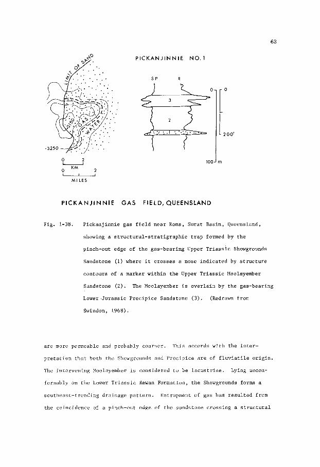
63
2 O- 0 KM 2
P l C K A N J l N N l E NO. 1
S P R
100 J m
- 0
- 2 0 0 '
- M I L E S
P I C K A N J I N N I E G A S FIELD, QUEENSLAND
Fig. 1-38. P i c k a n j i n n i e gas f i e l d n e a r Roma, Su ra t Bas in , Queensland,
showing a s t r u c t u r a l - s t r a t i g r a p h i c t r a p formed by t h e
pinch-out edge of t h e gas-bear ing Upper T r i a s s i c Showgrounds
Sandstone (1) where i t c r o s s e s a nose i n d i c a t e d by s t r u c t u r e
contours of a marker w i t h i n t h e Upper T r i a s s i c Moolayember
Sandstone ( 2 ) . The Moolayember i s o v e r l a i n by t h e gas-bearing
Lower J u r a s s i c P r e c i p i c e Sandstone (3 ) . (Redrawn from
Swindon, 1968).
a r e more permeable and probably coa r se r . This accords wi th t h e i n t e r -
p r e t a t i o n t h a t bo th t h e Showgrounds and P r e c i p i c e are of f l u v i a t i l e o r i g i n .
The i n t e r v e n i n g Moolayember i s cons idered t o be l a c u s t r i n e . Lying uncon-
formably on t h e Lower T r i a s s i c Rewan Formation, t h e Showgrounds forms a
sou theas t - t r end ing d ra inage p a t t e r n . Entrapment of gas has r e s u l t e d from
t h e co inc idence of a pinch-out edge of t h e sands tone c r o s s i n g a s t r u c t u r a l
64
nose draped over a b u r i e d h i l l on t h e eroded s u r f a c e of t h e igneous-meta-
morphic basement. The f i e l d i s consequent ly l i m i t e d t o t h e east by a
s t r a t i g r a p h i c pe rmeab i l i t y b a r r i e r , and i n o t h e r d i r e c t i o n s by s t r u c t u r a l
c l o s u r e .
The P i c k a n j i n n i e F i e l d c o n t a i n s proven p roduc ib le r e s e r v e s of gas
amounting t o more than 25,000 m i l l i o n cubic f e e t , of which approximately
15,000 m i l l i o n a r e w i t h i n t h e Showgrounds. The g a s , which c o n s i s t s of
96% methane, w a s i n i t i a l l y con ta ined a t a p r e s s u r e of about 1,900 p . s . i .
a t an approximate dep th of 1,500 m. The f i e l d has a s t r o n g water d r i v e ,
t h e water having a s a l i n i t y of less than 5,000 p.7.m. which p l a c e s i t i n
t h e compara t ive ly f r e s h t o b rack i sh water range.
Moonie O i l F i e l d , Queensland
The Moonie F i e l d (F ig . 1-39) is s i t u a t e d on t h e s o u t h e a s t e r n f l a n k
of t h e S u r a t Bas in , Queensland, and produces 4 5 O A.P.I. o i l from t h e Lower
J u r a s s i c P r e c i p i c e Sandstone. I n t h e f i e l d area, t h e P r e c i p i c e comprises
a lower sands tone u n i t t h a t l i e s unconformably on Permian and T r i a s s i c
rocks , and an upper sands tone u n i t s epa ra t ed from t h e lower by a s i l t y
s e c t i o n . A t Xoonie t h e P r e c i p i c e has a g r o s s th i ckness of approximate ly
75 m , and i s o v e r l a i n by s i l t s t o n e and mudstone of t h e Lower J u r a s s i c
Evergreen Formation.
Both t h e upper and lower sands tone u n i t s of t h e P r e c i p i c e a r e o i l -
-bear ing . The upper u n i t is l i g h t g r e y , f i n e t o medium-grained, poor ly
s o r t e d , qua r t zose t o l i t h i c , and has a w h i t e , k a o l i n i t i c m a t r i x . The
lower u n i t is l i g h t g r e y , medium t o very coarse-gra ined , i n p a r t cong-
l o m e r a t i c , poor ly s o r t e d , qua r t zose t o l i t h i c , and poorly-cemented t o
f r i a b l e . P o r o s i t y is i n t h e range 13-25%. Pe rmeab i l i t y of t h e upper
sands tone u n i t averages 300 m i l l i d a r c y s , and t h a t of t h e lower u n i t ranges
from s e v e r a l hundred t o 2,000 m i l l i d a r c y s . I n t h e Moonie F i e l d these

65
I
c
3
0 E L
o

66
sands tone u n i t s a r e sepa ra t ed by 100 f e e t o f l i g h t grey s h a l e and s i l t s t o n e
con ta in ing t h i n sands tone l a y e r s and coa ly laminae. This i n t e r v e n i n g u n i t
is cons idered t o have been deposited a s r i v e r f lood p l a i n and l a c u s t r i n e
sed iments . Both sands tone u n i t s are cross-bedded and of f l u v i a t i l e o r i g i n .
I n g e n e r a l , they e x h i b i t g r a i n g r a d a t i o n from c o a r s e r below t o f i n e r above,
a c h a r a c t e r i s t i c commonly found i n r i v e r sand d e p o s i t s . This f e a t u r e i s
r e f l e c t e d i n t h e blocky t o be l l - shaped s e l f - p o t e n t i a l curves o f t h e E-logs
shown i n F ig . 1-39.
O i l accumulation i n t h e Moonie F i e l d has r e s u l t e d from a s t r u c t u r a l -
s t r a t i g r a p h i c s i t u a t i o n where permeable zones w i t h i n the P r e c i p i c e Sandstone
o v e r l i e a basement ' h igh ' of b lock f a u l t e d and t runca ted Permian and
T r i a s s i c beds . The s t r u c t u r e w i t h i n t h e P r e c i p i c e i s a no r theas t - t r end ing
c losed dome, s i x m i l e s l ong and two mi l e s wide. The volume of o i l i n t h e
r e s e r v o i r i s e s t ima ted t o be about 125 m i l l i o n b a r r e l s (19 .9 m i l l i o n
c u b i c m e t r e s ) , b u t u l t i m a t e recovery w i l l p robably n o t exceed 35 m i l l i o n
b a r r e l s (5 .6 m i l l i o n cub ic me t re s ) . The o i l i s unde r l a in by f a i r l y f r e s h
wa te r (approximately 2,500 p .p .m.) , i n d i c a t i n g a hydrodynamic cond i t ion .
Product ion problems have a r i s e n as t h e r e s u l t of i nvas ion of t h e o i l -bea r ing
zone by wa te r .
Athabasca O i l Sands, A lbe r t a
The Athabasca O i l Sands (F ig . 1-40) c o n s i s t of t a r r y o i l - s a t u r a t e d
sands of t h e Lower Cre taceous McMurray Formation i n no r the rn Albe r t a .
These uncemented t o poorly-cemented sands , which o v e r l i e Devonian lime-
s t o n e s , have a very g e n t l e r e g i o n a l d i p t o t h e wes t and consequent ly crop
o u t , o r a r e c l o s e t o t h e s u r f a c e , over a wide a r e a . I n p l a c e s t h e sands
can b e mined i n open c u t s , a method c u r r e n t l y be ing employed; e l sewhere t h e
overburden is too t h i c k and o i l p roduct ion w i l l depend on sub-sur face
methods such as f i r e - f l o o d i n g o r steam i n j e c t i o n and t h e use of s o l v e n t s .

0'
100'
200'
3 0 0 '
L E G E N D X - B u r r o w s . . . . .I-] M I c r o - c r 0 s 1 - 1 o m no e . H I g h - a n g I e c ros I - s t r J t I f I c a t I on b- Tor Sands . . -
l i g . 1-40. Genera l ized s e c t i o n through t h e Athabasca a i l Sands of t h e
Lower Cre taceous McT4urray Formation, A l b e r t a , showing t h e
o i l - s a t u r a t e d b a s a l r i v e r sands and g r i t s , and ove r ly ing
f l u v i a l beds of t h e YuYurray Delta. (Af t e r Ca r r igy , 1971).
0'
100'
200'
300'

68
The o i l -bea r ing sands are qua r t zose and of f l u v i a t i l e and l a c u s t r i n e
o r i g i n . The lowermost sands have a th i ckness of 10-13 m. These c o n s i s t
of r i v e r d e p o s i t s , are coa r se t o very coa r se , and commonly have l e n s e s
of coa r se g r i t s t o n e and f i n e conglomerate composed of poorly-rounded
pebbles . Cross-bedding of t h e type found i n p o i n t b a r s is very common.
These sands a r e o v e r l a i n by a s e c t i o n , 30-45 m t h i c k , of sands and s i l ts
con ta in ing v a r i a b l e amounts of t a r r y o i l .
by t h e o r i g i n a l p o r o s i t y and pe rmeab i l i t y of t h e sands , t h e h ighe r v a l u e s
i n o i l con ten t be ing found i n t h e c l e a n , we l l - so r t ed f l u v i a t i l e sands .
Maximum o i l con ten t amounts t o 18-20% by weight of t h e s a t u r a t e d sand .
O i l s a t u r a t i o n i s c o n t r o l l e d
The Neocomian HcMurray Formation i s o v e r l a i n by marine beds of t h e
Lower Cre taceous (Albian) Clearwater Formation, t h e b a s a l u n i t of which i s
t h e Wabiskaw Member. This u n i t i s r e f e r r e d t o i n F ig . 1-40 a s a b a r r i e r
b a r s and , which i t may b e i n p a r t . C e r t a i n l y i t i s a t r a n s g r e s s i v e marine
sand .
t h e s e c t i o n , has a th i ckness of 50-100 m.
a r i v e r system t h a t d ra ined an a r e a of t h e Precambrian Sh ie ld t o t h e e a s t ,
and flowed nor thwes te r ly t o t h e Clearwater Sea. Subsequent t r a n s g r e s s i o n
of t h e sea r e s u l t e d i n b u r i a l of PlcXurray sed iments by t h e Clearwater
sands and muds.
The McMurray, which has a h ighe r sand conten t i n t h e lower p a r t of
The format ion w a s depos i t ed by
Regional d i p of t h e McMurray Formation, amounting t o less than 2m/km,
may have p e r n i t t e d t h e up-dip mig ra t ion of o i l t o i t s p r e s e n t l o c a t i o n , and
c o n s t i t u t e s t h e only b a s i s f o r a s t r u c t u r a l element t o t h i s v a s t accumulation
of o i l . The r e s e r v o i r , and t h e mechanisms c o n t r o l l i n g t h e l o c a l concent-
r a t i o n s of o i l are e n t i r e l y s t r a t i g r a p h i c . Xuch has been w r i t t e n by many
writers (Convbeare, 1966) about t h e p o s s i b l e o r i g i n s of t h e o i l , and t h i s
problem has n o t been exp la ined t o t h e s a t i s f a c t i o n of a l l . The ques t ion
may b e of academic i n t e r e s t o n l y , bu t t h e problems concerning product ion
from l e n t i c u l a r beds of v a r i a b l e pe rmeab i l i t y and o i l s a t u r a t i o n a r e of

69
consequence t o t h e f u t u r e a p p l i c a t i o n of sub-sur face p roduc t ion methods.
These problems may b e so lved as d r i l l i n g proceeds and subsu r face d e t a i l s
a r e eva lua ted and i n t e r p r e t e d t o show t h e r e l a t i o n s h i p s of pe rmeab i l i t y
t r ends t o d e p o s i t i o n a l t r ends w i t h i n t h e p a t t e r n of t h e b a s a l IlcMurray
dra inage system.
In t h e a r e a n o r t h of F o r t Mclurray t h e Athabasca O i l Sands a r e
es t imated t o con ta in more than 300,000 m i l l i o n b a r r e l s (57,700 m i l l i o n
cubic met res )of o i l . S i m i l a r accumula t ions i n o t h e r areas of no r the rn
Alber ta con ta in a d d i t i o n a l p o t e n t i a l r e s e r v e s .
r e se rves of o i l i n p l a c e probably amount t o 500,000 - 600,000 m i l l i o n
b a r r e l s , b u t how much of t h i s o i l can u l t i m a t e l y be produced as a v i a b l e
economic o p e r a t i o n is open t o ques t ion . The economic l i m i t may prove t o
be less than 200,000 m i l l i o n b a r r e l s (31,800 m i l l i o n cub ic me t re s ) .
The t o t a l p o t e n t i a l
The o i l which occupies up t o 90 pe rcen t of pore space i n t h e water-
-wet q u a r t z s and , can be s e p a r a t e d by t r ea tmen t w i th steam and h o t water .
It has a g r a v i t y of 10 degrees A . P . I . , a riaphthene base , and a r e l a t i v e l y
high con ten t of s u l p h u r , n i t r o g e n and t r a c e elements.
B e l l s h i l l Lake and Hughenden O i l F i e l d s , A lbe r t a
O i l p roduct ion i n t h e B e l l s h i l l Lake and Hughenden f i e l d s of east-
c e n t r a l .4lberta is ob ta ined from s t r a t i g r a p h i c t r a p s i n t h e Lower Cretaceous
(2eocomian) E l l e r s l i e Sandstone. This sands tone was depos i t ed as a r i v e r
sand i n a broad v a l l e y (F ig . 1-41) c u t i n t o the r e g i o n a l l y t i l t e d Devonian
carbonates and s h a l e s . The v a l l e y , which i s 15-65 km wide and more than
150 km long , t e rmina te s i n t h e a r e a of t h e El lers l ie d e l t a and t r ends
eastward t o a d ra inage source on t h e Precambrian S h i e l d . Heavy mine ra l
conten t of t h e E l l e r s l i e Sandstone i n d i c a t e s t h a t t h e sands were de r ived
from g r a n i t i c Precambrian rocks.
O i l accumula t ions i n t h e E l le rs l ie Sandstone are conta ined wi th in

EDMONTON 70
SANDSTONE, ALBER
RHINE DELTA, NETHERLAN
0 20KM
IDS
- 20 Miles O-
Fig . 1-41. Upper-Map showing t h e d i s t r i b u t i o n of t h e Lower Cre taceous
El le rs l ie Sandstone ( s t i p p l e d ) f i l l i n g a broad v a l l e y i n
Devonian ca rbona te s and s h a l e s (ha t chured ) , e a s t - c e n t r a l
A lbe r t a . Loca t ions of t h e B e l l s h i l l Lake F i e l d (1) and
Hughenden F i e l d (2) a r e shown. The c o n f i g u r a t i o n and s c a l e
of t h e areas of a l l u v i a l and d e l t a i c sed iments are remarkably
s imi la r t o those of t h e Rhine and Waal Rivers shown below.
Lower-Map showing t h e d i s t r i b u t i o n of f l u v i a l sands and si l ts
d e p o s i t e d i n t h e lower r eaches of t h e Rhine and Waal R ive r s ,
t h e Nether lands . These sed iments f i l l a broad v a l l e y i n
P l e i s t o c e n e d e p o s i t s (ha tchured) . (Redrawn from Geol-
o g i c a l Map of t h e Nether lands , compiled by Geologische
D i e n s t , 1951).

71
topographic e l e v a t i o n s ( i . e . b u r i e d sands tone h i l l s ) t h a t have s t r u c t u r a l
c losu re .
only because of t h e i r geometry b u t because they are f l anked by s h a l e s and
a t h i n l imes tone bed con ta in ing forams and os t r acods . Subsequent work
(Conybeare, 1964, 1972, and Mar t in , 1966) i n d i c a t e d t h a t t h e e l e v a t i o n s
are s t r u c t u r a l l y h igh p o r t i o n s of eroded r i v e r t e r r a c e s (F ig . 1-42) and
t h a t t h e r i v e r v a l l e y w a s subsequent ly inundated by an e s t u a r y t h a t produced
These e l e v a t i o n s were o r i g i n a l l y r e f e r r e d t o as sand b a r s , n o t
SOUTH 7-36-39-13-4 ALLIANCE FIELD BELLSHILL LAKE FIELD
WAEAMUN
___--- NISKU
_-
IRETON
Fig . 1-42.
NORTH 13 -28-42-12-4
0
100 m
S t r u c t u r a l s e c t i o n t r e n d i n g nor th-south a c r o s s t h e B e l l s h i l l
Lake and A l l i a n c e F i e l d s of e a s t - c e n t r a l A l b e r t a , showing
t h e o i l and gas-bearing Lower Cre taceous E l l e r s l i e Sandstone
ove r ly ing the eroded s u r f a c e of t h e Devonian Wabamun and
Nisku ca rbona te s .
McLennan 6-32, a w e l l i n t h e B e l l s h i l l Lake F i e l d . The
o i l -wa te r c o n t a c t is shown a t -715 f e e t (-218 m) below a
sea l e v e l datum. (E-log redrawn from Rudolph, 1960).
The i n s e t shown t h e E-log of R i c h f i e l d ,

1 2
a brackish-water , c o a s t a l marsh environment i n which muddy sediments w e r e
depos i t ed t o form a r e l a t i v e l y impermeable seal over t h e E l l e r s l i e sands .
The geometry and s i z e o f t h i s Neocomian r i v e r v a l l e y is s t r i k i n g l y similar
t o t h a t of t h e p r e s e n t v a l l e y of t h e Rhine River i n t h e Nether lands (F ig .
1-41).
The E l l e r s l i e Sands tone , which ranges i n th i ckness t o 75 m i s commonly
medium t o coa r se -g ra ined , f a i r l y well s o r t e d , and qua r t zose . Cross-bedding,
of t h e p l a n a r type found i n r i v e r p o i n t b a r d e p o s i t s , i s common. Gra in
g r a d a t i o n , from c o a r s e r below t o f i n e r above i n r e p e a t e d , t r u n c a t e d
sequences w i t h i n t h e E l le rs l ie Sandstone i n t e r v a l is a l s o ev iden t .
P o r o s i t y and pe rmeab i l i t y are g e n e r a l l y good, a l though l o c a l l y a f f e c t e d
by c a l c i t e cementa t ion . Rudolph (1959) s ta tes t h a t i n t h e B e l l s h i l l Lake
F i e l d t h e average p o r o s i t y exceeds 26%, and t h e average pe rmeab i l i t y i s
630 m i l l i d a r c y s . Loca l ly , t h e pe rmeab i l i t y ranges up t o 7,000 m i l l i d a r c y s .
I n t h e B e l l s h i l l Lake F i e l d t h e o i l column has a maximum th i ckness
of 16 m and an average th i ckness of 10 m. Flow r a t e s from i n d i v i d u a l w e l l s
were i n i t i a l l y i n t h e range 100-200 b a r r e l s of o i l per day , bu t product ion
rates were subsequent ly c u t back t o 25 b a r r e l s p e r day. The o i l has a
g r a v i t y of 28O A . P . I . Es t imated o i l i n p l a c e amounts t o 180 m i l l i o n
b a r r e l s , bu t wa te r d r i v e problems have caused d i f f i c u l t i e s i n p roduc t ion
and t h e u l t i m a t e y i e l d w i l l probably b e less than 35 m i l l i o n b a r r e l s
(5 .5 m i l l i o n cub ic me t re s ) .
The Hughenden Z i e l d (F ig . 1-43) con ta ins 15 m i l l i o n b a r r e l s of o i l ,
b u t accord ing t o Suey (1960) only 1.5 m i l l i o n b a r r e l s w i l l u l t i m a t e l y b e
recovered . The maximun th i ckness of t h e o i l - b e a r i n g sands tone i s 11 m , and
t h e average th i ckness is 7 m. Allowable product ion of t h e heavy o i l , which
has an average g r a v i t y of 1 7 O A . P . I . , was i n i t i a l l y a t t h e r a t e of 30
b a r r e l s p e r day.

73
R.8 R.7 W.4 M
A
Miles 0 5 K M -
B 0
CRETACEOUS E L L ERSL I E SANDSTONE
HUGHENDEN OIL FIELD. ALBERTA
Fig. 1-43. Map and s t r u c t u r a l s e c t i o n of t h e Hughenden F i e l d , east-
c e n t r a l A l b e r t a , showing t h e d i s t r i b u t i o n ( s t i p p l e d ) of t h e
Lower C r e t a c e o u s Ellerslie Sands tone occupying a U-shaped
loop i n a r i v e r v a l l e y w i t h i n t h e e roded c a r b o n a t e s and
s h a l e s of t h e Devonian Nisku and I r e t o n Format ions .
Regional d i p t o t h e s o u t h w e s t i s i n d i c a t e d by t h e arrow.
The f i e l d area l i e s w i t h i n Township 4 0 , Range 7 , West of t h e
4 t h Mer id ian , as shown i n A, and o c c u p i e s a s t r u c t u r a l l y
h i g h p a r t . (Redrawn from M a r t i n , 1 9 6 6 ) .
South Glenrock O i l F i e l d , Wyoming
I n t h e South Glenrock F i e l d (F ig . 1-44) s i t u a t e d on t h e s o u t h w e s t e r n
f l a n k of t h e Powder R i v e r B a s i n , Wyoming, p a r t of t h e o i l p r o d u c t i o n comes

74
SOUTH GLENROGK OIL FIELD c5=3 Oullinc T w o B u r i e d Slreom Chonnel i
ISOPACH LOWER MUDDY SHOWING TWO BURIED STREAM CHANNELS
Iwpach Contour 1nt.rvd - 10'
Sl ruc lur i Conlour Interval - 500'
Fig . 1-44. I sopach map of Lower Cre taceous Muddy Sands tone , South Glenrock
F i e l d , Wyoming, showing a meandering b e l t comprising two
channels . Contour i n t e r v a l i s 10 f e e t ( 3 m). (Af t e r Curry
and Curry , 1972) .
from channel sands tones a t t h e b a s e of t h e Lower Cretaceous Muddy Formation.
These channe l s , which a r e c u t i n t o t h e eroded s u r f a c e of t h e marine Lower
Cretaceous S k u l l Creek Formation, form a b e l t up t o 3 kn wide and more than
2 km long .

75
The sands tone bod ies f i l l i n g t h e s e channels are up t o 20 m t h i c k
and c o n s i s t mainly of f a i r l y well-rounded, we l l - so r t ed g r a i n s of q u a r t z
and c h e r t i n a m a t r i x of s i l t and c l a y . Carbonized p l a n t remains are
commonly abundant.
above, p o r o s i t y averages 14%, and pe rmeab i l i t y averages 82 m i l l i d a r c y s .
Gra in g r a d a t i o n v a r i e s from c o a r s e r below t o f i n e r
The o i l , produced from depths i n t h e range 1,700 - 1,800 m , ha s a
g r a v i t y of 370 A.P.I .
imated r ecove rab le r e s e r v e s of o i l amounted t o 50 m i l l i o n b a r r e l s .
estimate w a s based on recovery from t h r e e producing ho r i zons i n c l u d i n g ,
from o l d e r t o younger, d i s t r i b u t a r y and s h o r e l i n e sands of t h e Dakota
Following d i scove ry of t h e f i e l d i n 1950 t h e est-
This
O U 2 O L - 2
MILES KM
MEANDERING CHANNEL OF
SANDSTONE, MUDDY FORMATION
SOUTH GLENROCK FIELD
WYOMING
Fig . 1-45. Map of South Glenrock o i l f i e l d on t h e southwes tern f l a n k
of t h e Powder River Bas in , e a s t - c e n t r a l Wyoming.
s t i p p l e d area ahows t h e d i s t r i b u t i o n of a c l e a n , permeable
sands tone i n t h e lower p a r t of t h e Lower Cretaceous Muddy
Formation. The arrow i n d i c a t e s d i r e c t i o n of sediment t r a n s -
p o r t a t i o n . (Redrawn from Curry and Curry , 1954).
The

76
Formation, b a s a l r i v e r sands of t h e Muddy Formation, and younger Muddy
s h o r e l i n e sands . L a t e r estimates of Curry and Curry (1972) i n d i c a t e t h a t
t h e u l t i m a t e r ecove ry , by means of water f l o o d , may b e 75 m i l l i o n b a r r e l s
(12 m i l l i o n cub ic m e t r e s ) . The f i e l d has r e s u l t e d from a combination of
s t r a t i g r a p h i c and s t r u c t u r a l f a c t o r s , t h e o i l accumulation be ing s i t u a t e d
i n a t r a p where t h e channel is i n t e r s e c t e d by t h e a x i s of a s t r u c t u r a l f o l d
o r nose (F ig . 1-45).
It i s of p a r t i c u l a r i n t e r e s t t o n o t e t h a t t h e o i l -wa te r con tac t i n
t h e producing Dakota sands tone , a long t h e sou th s i d e of t h e f i e l d , has
225 m of tilt downdip t o t h e east a long t h e c r e s t of t h e s t r u c t u r a l nose.
This i n d i c a t e s a hydrodynamic c o n d i t i o n wi th a ve ry marked po ten t iome t r i c
g r a d i e n t .
Recluse O i l F i e l d , Wyoming
The Recluse F i e l d (Figs.l-46 and 1-47) i s s i t u a t e d on t h e n o r t h e a s t e r n
O i l i s ob ta ined from t h e Recluse f l a n k of t h e Powder River Bas in , Wyoming.
Sandstone a t t h e base of t h e Lower Cre taceous Muddy Formation a t a depth
of approximate ly 2,300 m. Th i s s ands tone , which a l s o y i e l d s oil i n t h e
nearby East Sandbar, H i l i g h t , and K i t t y f i e l d s , i s i n t e r p r e t e d by Woncik
(1972) a s a mar ine s h o r e l i n e sand , p o s s i b l y a b a r r i e r i s l a n d . On t h e o t h e r
hand , .Forgotson and S t a r k (1972) i n t e r p r e t t h e sands tone body as a channel-
- f i l l sand . In f a c t , t h e sands tone body comprises two u n i t s , each wi th a
d i f f e r e n t o i l -wa te r c o n t a c t i n t h e Recluse F i e l d . The body t r e n d s nor thwes t
f o r more than 24 k m and i s up t o 5 km wide.
dimensions of roughly 12 km by 3 km.
The o i l f i e l d i t s e l f has
The sands tone , which has a maximum th i ckness of 15 m and an average
o i l -bea r ing s e c t i o n of 8 m , i s q u a r t z o s e , has an average p o r o s i t y of 19%
and an average pe rmeab i l i t y of 300 m i l l i d a r c y s . Rese rvo i r p r e s s u r e i s
approximate ly 2,150 p . s . i . , which i s compara t ive ly low f o r t h a t p a r t i c u l a r
depth .

77
T 57 N
T 56 N
Fig. 1-46. I sopach map of Lower Cretaceous Muddy Sands tone , Recluse
F i e l d , Wyoming. Contour i n t e r v a l i s 10 f e e t (3 m). (Af te r
Woncik, 1972).
The o i l , which is produced a t an a l lowab le r a t e of 300 b a r r e l s per
day , has a g r a v i t y of 42O A.P.I. Cumulative p roduc t ion t o 1973 was 1 7
m i l l i o n b a r r e l s . T o t a l o i l i n p l a c e i s e s t ima ted t o b e 150 m i l l i o n
b a r r e l s , of which 20-40% (5-10 m i l l i o n cub ic met res ) may u l t i m a t e l y b e

78
1 58
N
1
57 N
1 56 N
LOWtR MUDDY l Y P f LOG . M O W R Y
1 I 7500'
ISOLITH LWR. MUDDY SS.
(SHOWING LOWER MUDDY PRODUCllON)
0 0 - 3 0 '
I> 3 0 '
0 < 80 ' T O T A L M U D D Y T H I C K N f S S
Fig . 1-47. I s o l i t h of t h e Upper Recluse Sandstone and Recluse Sandstone
which c o n s t i t u t e t h e lower p a r t of t h e Muddy Formation,
showing a l i n e a r p a t t e r n where t h e Recluse F i e l d i s more than
30 f e e t (9 m) t h i c k . (Af t e r S tone , 1972).
recovered economica l ly , depending on t h e r e s e r v o i r response t o p re s su re
maintenance. The recovery mechanism i s gas-so lu t ion d r i v e , t h e down-dip
p o r t i o n s of t h e sands tone body be ing only p a r t l y s a t u r a t e d wi th water.
The f i e l d is pure ly s t r a t i g r a p h i c , t h e o i l be ing t rapped by up-dip
pe rmeab i l i t y b a r r i e r s caused by p inching ou t of t h e sands tone . The only
s t r u c t u r a l element is a r e g i o n a l southwes t d i p , a l though Stone (1972)
s a y s t h a t i n some Lower Muddy o i l f i e l d s entrapment is provided by a
combination of s ands tone pinch-out and s t r u c t u r a l nos ing where a s t r u c t u r e
i n t e r s e c t s t h e t r e n d of a d i s t r i b u t a r y channel (Fig. 1-38).

79
Donkey Creek, Rozet , and O'Connor O i l F i e l d s , Wyoming
On t h e e a s t e r n f l a n k of t h e Powder R ive r Bas in , Wyoming, s e v e r a l
f i e l d s produce o i l from t h e Lower Cre taceous Newcastle Sandstone (Fig. 1-48) .
Stapp (1967) r eco rds t h a t t h e Newcastle, which has an average th i ckness of
9 m was depos i t ed i n a d e n d r i t i c r i v e r system t h a t d ra ined northward.
This r i v e r sys tem w a s developed penecontemporaneously wi th t h a t which
depos i t ed t h e b a s a l sands of t h e Muddy Formation i n t h e South Glenrock
F i e l d (F ig . 1-44) t o t h e s o u t h , as evidenced by t h e f a c t t h a t t h e channels
of t h i s system are a l s o c u t i n t o t h e e roded s u r f a c e of t h e marine Lower
Cretaceous S k u l l Creek Formation, as i s t h e s i t u a t i o n i n t h e South Glenrock
F i e l d . The s t r a t i g r a p h i c sequence on t h e e a s t e r n f l a n k of t h e b a s i n i s
s i m i l a r t o t h a t of t h e South Glenrock F i e l d area on t h e sou the rn f l ank .
Reservoi rs i n Lower Cretaceous beds have been formed n o t on ly i n t h e
- lo cr 0
1 MILES
Fig. 1-48. D e n d r i t i c d i s t r i b u t i o n of t h e Lower Cre taceous Newcastle
Sandstone i n p a r t of t h e Powder River Bas in , Wyoming. Areas
where o i l i s produced from t h e Newcastle a r e shown i n b lack .
Arrows i n d i c a t e northward d i r e c t i o n s of sediment t r a n s p o r t
i n t h e Newcastle r i v e r system. (Redrawn from Stapp , 1967).

80
Newcastle b u t a l s o i n t h e under ly ing marginal-marine ( d i s t r i b u t a r y and
s h o r e l i n e sands ) F a l l R ive r Sandstone and i n t h e ove r ly ing t r a n s g r e s s i v e
marine Dynneson Sandstone.
conf ined w i t h i n more permeable zones of sands tone beds where they a r e
bounded by up-dip edges , and consequent ly are pure ly s t r a t i g r a p h i c t r a p s .
Stapp (1967, p . 2055) concludes , “ O i l accumulation i s p r e s e n t i n t h e
up-dip edges of t h e o f f s h o r e , b lanket - type sands tone of t h e Dynneson,
t h e channel sands tone of t h e Newcastle, and t h e complex marginal-marine
sands tone of t h e F a l l River . P rospec t ing f o r such s t r a t i g r a p h i c t r a p s
r e q u i r e s an unders tanding of t h e pa l eodepos i t i ona l environments of t h e
rocks” .
O i l accumula t ions i n t h e Newcastle a r e
Coyote Creek and Miller Creek O i l F i e l d s , Wyoming
The Coyote Creek F i e l d and Miller Creek F i e l d (F ig . 1-49) are a l s o
s i t u a t e d on t h e e a s t e r n f l a n k of t h e Powder River Basin, Wyoming, approx-
ima te ly 15 km s o u t h e a s t and n o r t h e a s t r e s p e c t i v e l y from t h e Rozet F i e ld .
The producing zone i s t h e Lower Cre taceous F a l l S i v e r Sandstone which l i e s
approximate ly 60 m below t h e Newcastle Sandstone. Stapp (1967) says t h a t
t h e F a l l River comprises t h r e e s e p a r a t e sands tone bod ies which l o c a l l y
merge, as i n p a r t s of t h e Coyote Creek F i e l d , t o form a s i n g l e porous
u n i t approximate ly 25 m t h i c k . Elsewhere, t h e F a l l River ranges i n
t h i c k n e s s up t o 50 m . Stapp d e s c r i b e s t h e s e sands tone bod ies as having
been depos i t ed i n a marginal-marine environment, t h e lower two bodies
be ing s h o r e l i n e sands depos i t ed by a r e g r e s s i n g s e a .
i n t e r p r e t e d a s t h e b a s a l u n i t of a marine t r a n s g r e s s i v e sequence r e f e r r e d
t o as t h e S k u l l Creek Formation. Berg (1968), on tho o t h e r hand, states
t h a t t h e F a l l River Sandstone bod ies were, i n p a r t a t l e a s t , depos i t ed as
d e l t a d i s t r i b u t a r y p o i n t b a r s f l anked 3y muddy sediments w i t h i n t h e same
channel . H e s a y s , p . 2116, “Because t h e F a l l River is l a r g e l y of marine
and d e l t a i c o r i g i n , t h e r e s e r v o i r s ands tone was be l i eved t o have been
The upper sand is

81
N
A
/ CHANNEL FILL / / OIL-WATER CONTAC
/ /
ISOPACH OF POROUS SANDSTONE I N
POINT BARS OF FALL RIVER
SANDSTONE, WYOMING
Fig . 1-49. Isopach of n e t porous sands tone i n t h e o i l -producing Lower
Cre taceous F a l l R ive r Sands tone , Coyote Creek F i e l d (A)
and Miller Creek F i e l d ( B ) , Crook and Weston Count ies ,
Wyoming, showing o i l accumulation i n r i v e r p o i n t b a r s .
(Redrawn from Berg, 1968, and Truchot , 1963).
depos i t ed i n a l i t t o r a l environment, perhaps as a series of b a r r i e r - b a r
sands f l anked by l agoona l c l a y s .
been proposed f o r t h e s e sands tone beds at t h e West Moorcroft f i e l d
(Met t l e r , 1966) and a t Coyote Creek f i e l d (Bolyard and McGregor, 1966,
p . 2236)." Bolyard and McGregor i n t e r p r e t e d t h e F a l l River Sandstone
bodies as po in t - -bar channel d e p o s i t s a s s o c i a t e d wi th a d e l t a f r o n t .
They s a y , p. 2238, "The l i t h o l o g y , cross-bedding, c l a y g a l l s , and o t h e r
Recen t ly , however, a f l u v i a l o r i g i n has

82
f e a t u r e s a r e ve ry s imi la r t o those of t h i c k , mass ive , c h a n n e l - f i l l i n g
sands tone beds observed i n outcrop . I t i s d i f f i c u l t t o r e c o n s t r u c t a
p a t t e r n of convincing f a c i e s r e l a t i o n s t h a t would b e c o n s i s t e n t w i th
e i t h e r t h e o f f shore -ba r , b a r r i e r - i s l a n d , o r beach-deposit i n t e r p r e t a t i o n s " .
I n t h e Coyote and Miller Creek f i e l d s t h e F a l l River Sandstone is
l i g h t g rey t o w h i t i s h , q u a r t z o s e , f i n e t o medium-grained, and w e l l s o r t e d .
Carbonized p l a n t m a t t e r i s p r e s e n t throughout t h e i n t e r v a l . The n e t pay
comprises 10-15 m having a p o r o s i t y of 15-18% and a pe rmeab i l i t y t h a t
averages 200 m i l l i d a r c y s b u t ranges up t o 1,000 m i l l i d a r c y s . Both f i e l d s
are i n t e r p r e t e d by Berg (1968) as p o i n t b a r segments of a r i v e r meander
b e l t t h a t t r e n d s i n a nor th-south d i r e c t i o n f o r more than 50 km. This
t r e n d c o n t a i n s several o t h e r o i l f i e l d s of s i m i l a r o r i g i n .
The Coyote Creek and Mil ler Creek f i e l d s have e s t ima ted p roduc ib le
r e s e r v e s of 20 m i l l i o n b a r r e l s (3.2 m i l l i o n cub ic metres) of 41' A.P . I . o i l
and 5 m i l l i o n b a r r e l s of 33' A.P.I. o i l r e s p e c t i v e l y .
are a l s o e s t ima ted t o be i n t h e range 150-250 b a r r e l s pe r acre- foot . The
recovery mechanism i s an a c t i v e water d r i v e i n t h e Coyote Creek F i e l d and
a combined water and gas - so lu t ion d r i v e i n t h e Miller Creek F i e l d . The
. a r eas of t h e Coyote Creek and Miller Creek f i e l d s are approximate ly 2,000
and 1,000 acres r e s p e c t i v e l y .
U l t i m a t e r e c o v e r i e s
Reimers-Lane-Hart Trend, Nebraska
I n t h e Denver Basin of wes te rn Nebraska t h e R e i m e r s , Faro , Dal ton ,
Lane, Deep Creek and H a r t O i l f i e l d s form a nor th-south t r e n d (Fig. 1-50)
w i t h i n a Lower Cre taceous l i n e a r sands tone body. This body f i l l s a channel
c u t i n t o t h e "J" Member which is o v e r l a i n by t h e Lower Cretaceous Huntsman
Shale and u n d e r l a i n by t h e Lower Cre taceous S k u l l Creek Formation, bo th of
which are marine. The channel is a l s o l o c a l l y c u t i n t o t h e S k u l l Creek.
It h a s an average wid th of 450 m, a depth of 15-20 m, and a l eng th of more
than 30 Icm.

T 16
83
011 FIkt-DS IN CRETACEOUS RIVER DEPOSITS, NEBRASKA
A A'
F i g . 1-50. Map and s e c t i o n showing o i l a c c u m u l a t i o n s i n r iver d e p o s i t s
f i l l i n g a v a l l e y i n t h e Lower C r e t a c e o u s "J" s a n d s t o n e ,
Denver B a s i n , Nebraska . Arrow i n d i c a t e s t h e d i r e c t i o n of
r e g i o n a l d i p . (Redrawn from Harms, 1966).
84
The c h a n n e l - f i l l s ands tone i s predominantly l i g h t g rey , qua r t zose ,
f i n e t o medium-grained, and cross-bedded. Clays tone c h i p s , probably
de r ived from t h e e r o s i o n of d r i e d and cracked mud on t h e r i v e r banks ,
a r e f a i r l y common w i t h i n t h e sands tone .
s ands tone and da rk grey s i l t s t o n e show slump s t r u c t u r e s s imi la r t o those
formed i n t h e s i l t y , upper l a y e r s of p o i n t b a r d e p o s i t s .
are a l s o common, a s a r e carbonized p l a n t remains. I n g e n e r a l , t h e
sands tone body appears t o have been depos i t ed by a r i v e r , p o s s i b l y a
d i s t r i b u t a r y f lowing on a c o a s t a l p l a i n .
Some t h i n beds of l aye red
Scour s t r u c t u r e s
O i l has accumulated i n more permeable p a r t s o f t h e sands tone body
where i t i s g e n t l y fo lded by northwest-plunging a n t i c l i n e s t h a t c r o s s t h e
t r e n d of t h e channel . I n t h e s e producing s e c t i o n s t h e sands tone commonly
has p o r o s i t y and pe rmeab i l i t y i n t h e ranges 15-25% and 100 - 1,000 m i l l i -
darcys r e s p e c t i v e l y .
s t o n e body are h o r i z o n t a l b u t a t v a r i o u s e l e v a t i o n s .
format ion wa te r v a r i e s from 90,000 t o 110,000 ppm accord ing t o Harms (1966)
I n d i v i d u a l wells have an average p roduc t ion r a t e of 25,000 b a r r e l s of o i l
pe r y e a r , and t h e e s t ima ted cumula t ive product ion t h a t w i l l u l t i m a t e l y be
ob ta ined from a l l f i e l d s a long t h e t r e n d i s less than 10 m i l l i o n b a r r e l s
(1.6 m i l l i o n cubic me t re s ) .
The o i l -wa te r c o n t a c t s i n a l l f i e l d s a long t h e sand-
S a l i n i t y of t h e
Cut Bank O i l F i e l d , Montana
I n nor thwes tern Montana o i l p roduc t ion i n t h e Cut Bank F i e l d ,
s i t u a t e d on t h e w e s t f l a n k of t h e Sweetgrass Arch, i s ob ta ined from t h e
Lower Cre taceous Cut Bank Sandstone. This s ands tone , which f i l l s channels
c u t i n t o s h a l e s and s i l t y marine beds of t h e Upper J u r a s s i c Swif t Formation
and Rierdon Formation, is t h e b a s a l member of t h e Kootenai Formation and
i s o v e r l a i n by s e v e r a l hundred f e e t of non-marine, v a r i c o l o r e d mudstones
and s i l t y s ands tones . The channels form a meandering p a t t e r n t h a t t r ends

85
R 6 R 5 R 4 W
O- 5 KM
0 5 Miles
B B' YELLOW OWL I HARWOOD I
RIERDON
Fig. 1-51. D i s t r i b u t i o n of t h e Lower Cre taceous Cut Bank Sandstone where
i t i s more than 50 f e e t (15 m) t h i c k i n t h e Cut Bank o i l
f i e l d a r e a , Montana. I n s e t shows t h e l o c a t i o n . The arrow
i n d i c a t e s d i r e c t i o n of flow. (Redrawn f rom She l ton , 1967).

86
nor th-south . Drainage w a s t o t h e n o r t h and i n d i v i d u a l channels b i f u r c a t e
i n t h a t d i r e c t i o n . The l i m i t s of t h e Cut Bank Sandstone are broadly
de f ined by a d e p o s i t i o n a l edge f l a n k i n g t h e up-dip boundary of t h e o i l
f i e l d and by ou tc rops 50 km westward. Northward, t h e p a t t e r n of channels
ex tends f o r more than 80 km i n t o Albe r t a . The Cut Bank d ra inage system,
comprising a number of s e p a r a t e channe l s , w a s formed on a broad and f a i r l y
f l a t c o a s t a l p l a i n . The p a t t e r n of channels w i t h i n t h e Cut Bank F i e l d
(F ig . 1-51) can b e de f ined by a n i sopach map of t h e Cut Bank Sandstone
showing t h i c k n e s s s s exceeding 15 m (She l ton , 1967). These meandering
channels commonly have a wid th of 450-1,200 m and a th i ckness o f up t o 25 m .
Where t h e Cut Bank Sandstone c rops o u t , 50 km southwest of t h e f i e l d , i t
h a s a t h i c k n e s s of up t o 70 m .
The sands tone is composed mainly of g r a i n s of q u a r t z and dark grey
c h e r t .
g r a i n s i z e g r a d a t i o n i s w e l l de f ined w i t h i n sequences of l a y e r s , ranging
from coa r se below t o f i n e above. Loca l ly , t h e coarse-gra ined l a y e r s are
conglomera t ic , t h e maximum pebble s i z e be ing 15 mm.
common f e a t u r e ; o t h e r sed imentary s t r u c t u r e s i n c l u d e burrows (?> , c lays tone
ch ips (probably fragments of d r i e d mud), and deformat ion probably caused bv
slumping of t h e unconsol ida ted sediment i n a h y d r o p l a s t i c s ta te (Conybeare
and Crook, 1968). A s h a l e bed , l o c a l l y p re sen t w i t h i n t h e upper p a r t o f t h e
Cut Bank Sands tone , con ta ins f resh-water o s t r acods and
Within i n d i v i d u a l l a y e r s t h e g r a i n s are f a i r l y w e l l s o r t e d , bu t
Cross-bedding i s a
gas t ropods . P o r o s i t y of t h e sands tones is i n t h e ranges 12-19%, pe rmeab i l i t y
ranges up t o 300 m i l l i d a r c y s and averages 100 m i l l i d a r c y s . The b e s t va lues
f o r p o r o s i t y and pe rmeab i l i t y are found i n t h e medium-grained sands tone ,
whereas poore r v a l u e s are found i n bo th t h e f ine -g ra ined and conglomera t ic
s ands tones .
O i l p roduc t ion (F ig . 1-52) i s more p r o l i f i c i n t h e t h i c k e r p a r t s of
t h e sands tone bod ies w i t h i n t h e channe l s , b u t is n o t p r e c i s e l y confined
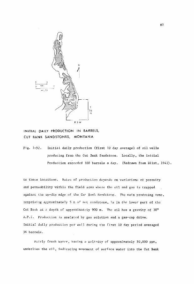
0 5
0 KM I
M I L E S
I/
I N I T I A L DAILY P R O D U C T I O N IN BARRELS,
CUT B A N K S A N D S T O N E S , M O N T A N A
Fig . 1-52. I n i t i a l d a i l y p r o d u c t i o n ( f i r s t 10 day average) of o i l w e l l s
p roducing from t h e Cut Bank Sands tone . L o c a l l y , t h e i n i t i a l
P r o d u c t i o n exceeded 100 b a r r e l s a day. (Redrawn from B l i x t , 1941).
t o t h e s e l o c a t i o n s . Rates of p r o d u c t i o n depends on v a r i a t i o n s of p o r o s i t y
and p e r m e a b i l i t y w i t h i n t h e f i e l d area where t h e o i l and g a s i s t r a p p e d
a g a i n s t t h e up-dip edge of t h e Cut Bank Sands tone . The main producing zone ,
compr is ing a p p r o x i m a t e l y 5 m of n e t s a n d s t o n e , i s i n t h e lower p a r t o f t h e
Cut Bank a t a d e p t h of a p p r o x i m a t e l y 900 m .
A .P . I . P r o d u c t i o n is a s s i s t e d by g a s s o l u t i o n and a gas-cap d r i v e .
I n i t i a l d a i l y p r o d u c t i o n p e r w e l l d u r i n g t h e f i r s t 10 day p e r i o d averaged
56 b a r r e l s .
The o i l h a s a g r a v i t y of 3 8 O
F a i r l y f r e s h w a t e r , h a v i n g a s a l i n i t y of a p p r o x i m a t e l y 10,000 ppm,
u n d e r l i e s t h e o i l , i n d i c a t i n g movement of s u r f a c e water i n t o t h e Cut Bank

88
Sandstone.
of t i l t i n g of t h e o i l -wa te r c o n t a c t .
y i e l d more than 30 m i l l i o n b a r r e l s (4 .8 m i l l i o n cub ic me t re s ) of o i l and
80,000 m i l l i o n cub ic f e e t (2,200 m i l l i o n cub ic me t re s ) of gas .
This hydrodynamic s i t u a t i o n may have caused some s l i g h t degree
The Cut Bank F i e l d may u l t i m a t e l y
Nahorkatiya O i l F i e l d , A s s a m
O i l p roduc t ion i n t h e Nahorkatiya F i e l d of A s s a m is ob ta ined from
sands tones w i t h i n a 300 m i n t e r v a l i n t h e upper p a r t of t h e Oligocene Barail
Series. These sands tones o r i g i n a t e d as r i v e r channel sands (F ig . 1-53)
depos i t ed on a f a i r l y f l a t f l o o d p l a i n of s i l t and c l a y i n t h e upper reaches
of a d e l t a . I n d i v i d u a l channe l s , which range i n th i ckness t o 30 m and i n
wid th t o more than 450 m , are in te rbedded wi th t h i n beds of c o a l and
l i g n i t e formed i n backswamp areas of a r i v e r f l o o d p l a i n . More than 50
0 I i- -~ . ~ ~ ~~ _1
Km
E-LOG SECTION OF CHANNEL SANDS NAHORKATIYA FIELD ASSAM
Fig . 1-53. E-log s e c t i o n showing o i l -bea r ing r i v e r channel sands i n the
Oligocene B a r a i l Series, Nahorkatiya F i e l d , A s s a m . (Redrawn
from Azad, Bhat tacharyya , D a t t a , and S tevens , 1971).

89
r o
E-LOG OF CHANNEL SANDS,
NAHORKATIYA FIELD, ASSAM.
Fig. 1-54. E-log of a composite channel sand i n t h e Oligocene Barail
S e r i e s , Nahorkatiya O i l f i e l d , A s s a m . Three s e p a r a t e channels
are superimposed, each grading upward from coa r se sand t o s i l t .
Note t h e c h a r a c t e r i s t i c be l l - shape of t h e l o g of each channel.
(Redrawn from Azad, Bhat tacharyya , Datta, and Stevens , 1971).
s e p a r a t e channels have been recognized i n t h e Nahorkatiya F i e l d .
l o c a t i o n s , two o r more channels are superimposed (F ig . 1-54) t o form
sands tone u n i t s more than 50 m t h i c k . The e l e c t r i c l og c h a r a c t e r of many
of t h e s e channel sands shows t h e t y p i c a l be l l - shape i n d i c a t i n g g r a i n grad-
a t i o n from c o a r s e r below t o f i n e r above.
A t some
O i l accumulation is c o n t r o l l e d by a combination of s t r a t i g r a p h i c
and s t r u c t u r a l f a c t o r s . Reg iona l ly , t h e Barail S e r i e s d i p s away from a
basement r i d g e . This s t r u c t u r a l element has probably been impor tan t i n
c o n t r o l l i n g t h e d i r e c t i o n of mig ra t ion and e x t e n t of t h e area unde r l a in
by accumulations of o i l . L o c a l l y , t h e o i l has accumulated i n t r a p s con-
t r o l l e d by f a u l t i n g and p inch ing o u t of t h e channel sands . The o i l ,
which i s waxy and has a g r a v i t y of 3 3 O A.P.I. i n a l l t h e s e p a r a t e r e s e r v o i r s ,

90
i s thought t o have o r i g i n a t e d i n marine s h a l e s and l imes tones o f t h e under-
l y i n g Eocene sequence.
Maikop O i l F i e l d , U.S.S.R.
The Maikop F i e l d (F ig . 1-55) i n t h e Black Sea rea, U . S . S . R . , produces
o i l from meandering T e r t i a r y channel sands . These s h o e s t r i n g sand bod ies
meander a t v a r i o u s levels w i t h i n a c l a y - f i l l e d v a l l e y c u t i n t o Cre taceous
marly l imes tone . The main producing sand body, which i s s t r a t i g r a p h i c a l l y
t h e h i g h e s t , i s 150-300 m wide and more than 8 km long . It i s g e n e r a l l y
conf ined t o t h e v a l l e y , bu t i n p l a c e s meanders ou t of t h e v a l l e y on t o t h e
sur rounding f lood p l a i n . The sands , which a r e encountered a t ve ry sha l low
SANDS --
TERTIARY RIVER CHANNEL MAIKOP OIL FIELD
U.S.S. R.
Fig . 1-55. Map and s e c t i o n s of bu r i ed stream-channel sands i n a clay-
f i l l e d T e r t i a r y v a l l e y , Maikop o i l f i e l d , Black Sea a r e a ,
U.S.S.R. (Redrawn from Prokopov and Maksimov, 1937).

91
depths of a few hundred metres, have good porosity and permeability. They
are commonly medium to coarse-grained, but locally include grit and gravel.
Entrapment of oil has resulted from a combination of stratigraphic
and structural factors by which closure results from the coincidence of
meander belts and a monocline dipping northward from the Caucasus Mountains.
Initial rates of production from some wells have ranged up to 7,000 barrels
of oil per day, and the amount of oil that can ultimately be recovered from
the field is estimated to exceed 15 million barrels ( 2 . 4 million cubic
metres).

This Page Intentionally Left Blank

93
Chapter 2
DISTRIBUTARY AND DELTA-FRINGE SAND
Introduction
Geomorphology
Patterns of deltas are ephemeral. They change continuously in
response to, (a) shifts in the courses of distributaries, (b) to fluct-
uations in the load of sediments transported to the delta and seashore,
(c) to variations in rates of compaction causing uneven subsidence in
different parts of the delta, (d) to the effects of storms and tidal
changes and, (e) to the bathymetry of the continental shelf on which the
delta is building outward.
foot delta of the present-day Mississippi River has been formed as a result
of the shallowness of the continental shelf and the comparative slight
variations in tidal levels. By contrast, the Niger River cuspate-arcuate
delta (Fig. 1 - 3 ) , currently building outward on a very narrow continental
shelf subject to large tidal variations with strong current and wave action,
has smooth, curved shoreline of delta-fringe sands.
The dendritic pattern of the classic birds-
Viewed in three dimensions, an ever-changing delta pattern is only
the surface or geographic expression of a prograding lobe of sediment, of
irregular outline and variable thickness, that is building seaward in
response to fluctuations in the rate of sedimentation.
ically changes course and discharges its load of sediment in other parts of
the delta, it successively builds a sequence of lobes. These lobes not only
prograde seaward, but merge laterally to fbrm piles of sediment which them-
selves may merge with piles from adjacent rivers to constitute the paralic
facies of a sedimentary basin.
A s a river period-
From a paleogeomorphic point of view, the

94
d e n d r i t i c and anastomosing p a t t e r n of d i s t r i b u t a r i e s i n t h e Miss i s s ipp i
River d e l t a complex (Fig. 2-1) i s t h r e e dimensional.
downward i n t o Recent and T e r t i a r y s e c t i o n s underlying t h e present-day
d e l t a , s u b s t a n t i a t i n g t h e view t h a t depos i t i ona l p a t t e r n s and sedimentol-
o g i c a l processes observed today i n t h e Miss i s s ipp i Del ta a r e r e p e t i t i o n s
of those marking t h e geo log ica l h i s t o r y of t h e underlying T e r t i a r y .
The p a t t e r n extends
Of p a r t i c u l a r i n t e r e s t i n t h e f i e l d of petroleum exp lo ra t ion a r e t h e
three-dimensional p a t t e r n s of modern d i s t r i b u t a r y and de l t a - f r inge sand
bod ies , t h e geometry of t hese bod ies , and t h e i r i n t e r n a l f e a t u r e s such a s
sedimentary s t r u c t u r e s , g r a i n g rada t ion , and l i t h o l o g i c v a r i a t i o n s . The
s p a t i a l a s s o c i a t i o n s of t h e s e bodies with ad jacen t beds, and t h e n a t u r e
of t hese beds, a r e e s s e n t i a l t o t h e i n t e r p r e t a t i o n of t h e o r i g i n s of t h e
sandstone bodies .
KM M I L E S /
D I ST R I BUTA RY C H A N N E LS, M I S S I SS I PP I D E LTA
Fig. 2-1. P a t t e r n of a c t i v e and abandoned d i s t r i b u t a r y channels of
The Miss i s s ipp i d e l t a . (Redrawn from Kolb and van Lopik,
1966).

95
I n t h e lower reaches of a d e l t a bo rde r ing t h e s h o r e , where t h e s u r f a c e
of t he subs id ing landmass has a n e l e v a t i o n of less than one metre above sea
l e v e l , t h e main d i s t r i b u t a r i e s f low through areas of marsh. The channels ,
bounded by l e v e e s , are commonly h ighe r t han t h e sur rounding marshlands
which r e c e i v e s mud and s i l t du r ing t i m e s of f l o o d when t h e d i s t r i b u t a r i e s
overflow t h e i r banks. Sands are conf ined t o channels i n which they are
t r anspor t ed t o t h e d i s t r i b u t a r y mouths where they are depos i t ed and subseq-
uen t ly swept by ocean c u r r e n t s t o form d i s t r i b u t a r y mouth b a r s (F ig . 2-2) .
A s t h e d i s t r i b u t a r y con t inues t o grow seaward i t cont inuous ly over - r ides
t h e sand b a r s a t i t s mouth t o form a prograding , l i n e a r sand body r e f e r r e d
t o by F i s k (1961) as a ba r - f inge r . The upper and c e n t r a l p a r t o f such a
sand body, be ing conf ined t o t h e channel , i s f l u v i a l and may show i n t e r n a l
f e a t u r e s c h a r a c t e r i s t i c of t h i s o r i g i n . The lower and l a t e r a l l y more
ex tens ive p a r t of t h e sand body may show i n t e r n a l f e a t u r e s , such as g r a i n
g rada t ion from c o a r s e r above t o f i n e r below (Fig. Z-ZC), c h a r a c t e r i s t i c
of a s h o r e l i n e sand. Th i s appa ren t anomaly i n t h e d e p o s i t i o n a l environment
of t h e sands tone body p e r t a i n s on ly t o t h a t p a r t of t h e d i s t r i b u t a r y sand
body t h a t has been b u i l t o u t i n t o t h e sea. The r e m i n d e r of t h e body, which
i n many examples probably r e p r e s e n t s t h e longe r p o r t i o n of t h e d i s t r i b u t a r y ,
is e n t i r e l y of f l u v i a l o r i g i n . These r e l a t i o n s h i p s i l l u s t r a t e some of t h e
d i f f i c u l t i e s encountered i n recogniz ing t h e o r i g i n of a sands tone body i n
t h e subsur f ace .
The p r o g r a d a t i o n a l sequence o f d e l t a d i s t r i b u t a r i e s , c h a r a c t e r i z e d
by g r a i n g r a d a t i o n from c o a r s e r above t o f i n e r below, i s seen n o t on ly i n
ba r - f inge r sands b u i l d i n g o u t t o sea on a sha l low sea f l o o r , bu t a l s o i n
t h e seaward ex tens ion of c o a s t a l sand bod ies such as b a r r i e r b a r s . Upstream,
t h e ba r - f inge r s merge i n t o sand bod ies depos i t ed i n d i s t r i b u t a r y channels
where t h e f l u v i a l sequence i s c h a r a c t e r i z e d by g r a i n g r a d a t i o n from coa r se r
below t o f i n e r above, provided t h a t t h e sand i s n o t uniform i n g r a i n s i z e .

96
\
A
PRODELTA
PRODE LTA 9 c 9 I-
GEOMETRY AND GRAIN GRADATION OF
FINGER SAND
BA. R
F i g . 2-2. A - P l a n v iew of a b a r - f i n g e r s a n d body formed a t t h e mouth
of Southwest P a s s , a main d i s t r i b u t a r y i n t h e b i r d f o o t
d e l t a of t h e M i s s i s s i p p i R i v e r , showing t h e d i s t r i b u t i o n
of s a n d s i n t h e d i s t r i b u t a r y mouth b a r , and of s a n d s and
s i l ts i n t h e d i s t a l b a r o v e r - r i d i n g t h e p r o d e l t a s i l t s
and c l a y s . (Redrawn from Coleman and G a g l i a n o , 1965).

97
Another p o s s i b l e f a c t o r i n t h e development of ba r - f inge r s h a s been
poin ted o u t by Moore (1970). H e s ays t h a t t h e l i n e a r bod ie s of f ine-gra ined
sand i n t h e M i s s i s s i p p i River d i s t r i b u t a r i e s , termed ba r - f inge r s , are formed
no t only by t h e seaward growth of prograding d is t r ibu tary-mouth b a r s , bu t
a l s o by t h e i n t r u s i o n of a s a l t wa te r wedges i n t o t h e d i s t r i b u t a r y channel
dur ing pe r iods of less than maximum d i scha rge . A wedge causes r educ t ion i n
t h e bottom-carrying power of t h e d i s t r i b u t a r y and r e s u l t s i n d e p o s i t i o n of
a sand s i l l (Fig. 2-3) t h a t mig ra t e s w i th t h e ebb and f low of t h e wedge a long
t h e lower course of t h e d i s t r i b u t a r y .
The geometry of ba r - f inge r sand bod ies has been desc r ibed by F i sk
(1961) and Gould (1970). Each ba r - f inge r is a prograding , l i n e a r body
formed by a c c r e t i o n of d i s t r ibu tary-mouth sand b a r s (F ig . 2 - 4 ) . A t any
p o i n t i n t i m e , t h e sand b a r forms a n a r c u a t e body of sand t h a t has a w id th ,
normal t o t h e cour se of t h e d i s t r i b u t a r y , of 5-8 km. Deposited i n sha l low
B - Cross-sec t ion of a ba r - f inge r sand a t t h e mouth of a
d e l t a d i s t r i b u t a r y , showing t h e channel f l anked by
l e v e e s and u n d e r l a i n by sands depos i t ed as a d i s t r i b u t a r y
mouth b a r , and by satid and s i l t depos i t ed as a d i s t a l
b a r o v e r r i d i n g p r o d e l t a s i l ts and c l a y s . No scale.
(Redrawn from F i s k , 1961).
C - E-log c h a r a c t e r i s t i c s of a p rograda t iona l sequence from
coarser -gra ined above t o f ine r -g ra ined below, such as
t h e sequence shown i n t h e b a r f i n g e r sand body i l l u s t r a t e d
by A and B. (Redrawn from F i s h e r , 1969 and F i s h e r e t aZ . ,
1969).

98 S E C T I O N A L O N G DELTA DlSTRtBUTARY
R I V E R L E V E L - 0 , I _____ ~ ' 1 SEA LEVEL ~~~~~~
+-.- F R E S H WATER
I ' IOG'
50 " 0 25 0 25 L - ~ _ _ _ 4 L-
M I I EL K M
Fig . 2-3. Diagrammatic s e c t i o n a long t h e channel of a d e l t a d i s t r i b u t a r y ,
showing t h e r e l a t i o n s h i p s of a sand s i l l and wedge of sa l t
water w i t h i n t h e f resh-water channel. (Redrawn from Moore,
1970).
A /
LJ M I L E S
A
0- 2 K M
A' 0 FEET
400 0 10
0 10 M I L E S
K M
BAR - FINGER SAND, MISSISSIPPI DELTA.
Fig . 2-4. P l an and s e c t i o n a l views i l l u s t r a t i n g p rograda t ion du r ing
t h e y e a r s 1764 t o 1959, of t h e ba r - f inge r sand body forming
Southwest Pass, M i s s i s s i p p i River. Sec t ion A-A' shows t h e
t r a c e s of t i m e p l anes w i t h i n t h e ba r - f inge r sand body (1)
which o v e r l i e s d e l t a - f r o n t s i l t s ( 2 ) and p r o d e l t a c l a y s ( 3 ) .
(Redrawn from Gould, 1970, a f t e r F i s k , 1961).

99
water a t t h e mouth of a d i s t r i b u t a r y , t h e sand g rades seaward t o s i l t and
c l ay . Prograding seaward, t h e ba r - f inge r grows as a d iachronous sand body,
time-planes (o r t h e i r t r a c e s seen i n s e c t i o n s having a n en echeZon and
d iagonal arrangement w i t h i n t h e sand body.
up t o 75 m t h i c k and 30 km long . Lateral and v e r t i c a l growth o f t h e d e l t a
complex r e s u l t s i n t h e ever-changing p a t t e r n of ba r - f inge r sand bod ies
Bar- f inger sand bodies can b e
HIGH TIDE
-22
0 1 2 I I
Km
MOUTH OF PO RIVER AT PlLA
Fig . 2-5. Arcuate sand b a r s ( s t i p p l e d ) formed a t t h e mouth of t h e Po
River a t P i l a , and a s e c t i o n through s t a t i o n s 3 t o 2 2 showing
t h e conf igu ra t ion of t h e wave-built b a r s and under ly ing wedge
of sand . (Redrawn from Melson, 1970).

100
Fig . 2-6. S tages i n development of a b i r d f o o t d e l t a and d e p o s i t i o n of
a d e l t a i c sequence , showing growing p a t t e r n of b i f u r c a t i n g
d i s t r i b u t a r i e s , and s t r a t i g r a p h i c sequence through a s e c t i o n
a t v a r i o u s s t a g e s . (Af t e r L e Blanc, 1972, and F i s k , 1961).

101
0 20 40 b0
80
F i g . 2-6. (Continued).

102
0 10 40 b0 80
0 20 40 bO
80
Fig. 2-6. (Continued)

103
b u i l d i n g up through t h e s e c t i o n t o form a complex of anastomosing s h o e s t r i n g -
-sand bod ies s e p a r a t e d by l e n t i c u l a r l a y e r s of s i l t and c l a y .
Another modern example of d i s t r ibu tary-mouth sand b a r s has been
desc r ibed by Nelson (1970). This i s t h e complex o f sand b a r s a t t h e mouth
of t h e Po R ive r at P i l a , I t a l y (F ig . 2-5). These b a r s form a r c u a t e i s l a n d s
on t h e seaward pe r iphe ry of a prograding wedge of sand which is up t o 15 m
t h i c k and 3 km wide.
L e Blanc (1972), based on s t u d i e s of t h e M i s s i s s i p p i d e l t a ba r - f inge r
sands , ( F i s k , 1961) i l l u s t r a t e d t h e growth of a d e l t a complex i n F ig . 2 - 6 .
These diagrams show t h e s t a g e s of development of a b i r d f o o t d e l t a i n a
d e l t a complex comprising b i f u r c a t i n g d i s t r i b u t a r i e s s e p a r a t e d by swamp.
lobes of t h e d e l t a prograde and s h i f t l a t e r a l l y , t h e sand bod ies depos i t ed i n
o l d e r d i s t r i b u t a r y channels are b u r i e d t o form a system of anastomosing
shoes t r ing-sands i n t h e subsu r face .
A s
L e Blanc (1972) f u r t h e r p o i n t s o u t (F ig . 2-7) t h a t such lobes coa le sce ,
by la teral s h i f t i n g r e s u l t i n g from changes i n t h e cour ses o f i t h e d i s t r i b -
u t a r i e s , t o form a d e l t a p l a i n t h a t may have a wid th exceeding 160 km. I n
t h e subsu r face a b u r i e d d e l t a p l a i n is u n d e r l a i n by a s t r a t i g r a p h i c complex
of s i l t s and c l a y s in t e rbedded wi th sand bod ies formed as d i s t r i b u t a r y
channel s ands , ba r - f inge r s ands , beach b a r s , and b a r r i e r i s l a n d s . I n g e n e r a l ,
d e p o s i t i o n a l t r e n d s of t h e channels and ba r - f inge r s are approximate ly normal
t o those of t h e s h o r e l i n e b a r s and b a r r i e r i s l a n d s .
E-log C h a r a c t e r i s t i c s
The c o a s t a l f r i n g e of each d e l t a l o b e i n c l u d e s ba r - f inge r sands which
prograde seaward.
s i l t and c l a y , t h e r e s u l t i n g g r a i n g r a d a t i o n be ing r e f l e c t e d i n a serrate,
funnel-shaped s e l f - p o t e n t i a l curve on t h e E-log. Th i s shape i n d i c a t e s ,
(a) a g r a d a t i o n a l c o n t a c t , sand l e n s e s be ing in te rbedded w i t h l a y e r s of
P rograda t ion r e s u l t s i n t h e sand ove r - r id ing p r o d e l t a

104
Ili i
F i g . 2-7. S t a g e s i n development of a d e l t a - p l a i n complex and s t ra t i -
g r a p h i c sequence r e s u l t i n g from t h e c o a l e s c e n c e of s e p a r a t e
d e l t a l o b e s . ( A f t e r Le Blanc , 1972) .

105
STACE I

106
s i l t and c l a y and, (b) a g e n e r a l t h i cken ing upward of t h e sand l a y e r s ,
commonly w i t h an i n c r e a s e i n g r a i n s i z e . In t h e lower p a r t of t h e bar -
- f i n g e r sequence, i n t e rbedded l a y e r s o f sand , s i l t , and c l a y are depos i t ed
as t h e r e s u l t of f l u c t u a t i o n s i n t h e r i v e r f lood c y c l e s . During f lood
s t a g e s sand is depos i t ed seaward from t h e d i s t r i b u t a r y mouth, whereas
du r ing low-water s t a g e s t h e sediment depos i t ed c o n s i s t s mainly of s i l t o r
c l a y . A s t h e d i s t r i b u t a r y advances, and t h e b a r - f i n g e r progrades seaward,
t h e sediment depos i t ed a t any l o c a t i o n w i t h i n t h e lower reaches of a
d i s t r i b u t a r y channel becomes i n c r e a s i n g l y sandy. The r e s u l t is t h a t a
s e c t i o n through a d i s t r i b u t a r y channel n e a r i ts mouth shows an o v e r a l l
upward i n c r e a s e i n g r a i n s i z e .
D i s t r i b u t a r y channel sand bod ies may ove r - r ide o r c u t through d e l t a -
--marine f r i n g e sands , and l o c a l l y can be d i s t i n g u i s h e d from t h e l a t t e r by
t h e i r be l l - shaped o r c y l i n d r i c a l s e l f - p o t e n t i a l curves .
r eaches of a d i s t r i b u t a r y channel t h e curve tends t o b e be l l - shaped ,
i n d i c a t i n g g r a i n g r a d a t i o n from f i n e r above t o c o a r s e r below.
lower r eaches , subs idence of t h e d i s t r i b u t a r y channel sand body, and f a i r l y
uniform rates of flow and sed imen ta t ion , can r e s u l t i n a t h i c k sand body
of uniform g r a i n s i z e . Th i s t ype of sand body is c h a r a c t e r i z e d by a
c y l i n d r i c a l s e l f - p o t e n t i a l curve . A s e r r a t e d curve i n d i c a t e s i n t e r b e d s of
In t h e upper
I n t h e
s i l t and c l a y depos i t ed du r ing p e r i o d i c dec reases i n t h e v e l o c i t y of t h e
d i s t r i b u t a r y .
- Compaction
Prograding ba r - f inge r sand bod ies are over-ridden by d i s t r i b u t a r y
channels as t h e sho re - l ine retreats. These channe l s , which commonly are
only one t h i r d t o one f i f t h as wide as t h e seaward-trending ba r - f inge r sand
b o d i e s , converge landward t o form l a r g e r channels . The ba r - f inge r sand
bod ies , merge l a t e r a l l y a t the s u r f a c e .
and s i l ts , may cause them t o merge o r l o c a l l y come i n t o c o n t a c t i n t h e
Compaction of t h e sur rounding muds

107
subsur face . In consequence, where viewed i n t h r e e dimensions, t h e s e bar -
- f inge r sand bodies may have an en eckeZon arrangement i n s e c t i o n s bo th
normal and p a r a l l e l t o t h e g e n e r a l d e p o s i t i o n a l t r e n d . Th i s arrangement
f a c i l i t a t e s t h e movement o f f l u i d s through t h e sand bod ies du r ing compaction.
The movement is g e n e r a l l y l a t e ra l and upward i n t h e s t r a t a , a long more
permeable zones t h a t t r e n d up t h e d e p o s i t i o n a l s l o p e toward t h e margin of
t he sed imentary p i l e . It may b e i n f e r r e d t h a t f l u i d s expe l l ed from
compacting muds w i l l move i n t o b a r - f i n g e r sand bod ies and mig ra t e upward
a long t h e b u r i e d d i s t r i b u t a r y channel sand bod ies . In f a c t , t h e movement
of format ion f l u i d s through t h e sand bod ies may b e i n h i b i t e d by penecontemp-
oraneous slumping of l a r g e b locks of sed iment , forming f a u l t s which r e s t r i c t
t h e movement of f l u i d s and r e s u l t i n above-normal f l u i d p r e s s u r e s i n
i s o l a t e d bod ies of sand ,
Loca l warping of d i s t r i b u t a r y channel and ba r - f inge r sand bod ies ,
caused by compaction o r t e c t o n i c deformat ion , may r e s u l t i n numerous c losu res
which can become m u l t i p l e s t r a t i g r a p h i c o r s t r a t i g r a p h i c - s t r u c t u r a l t r a p s
f o r o i l and gas . Many such m u l t i p l e pay-zones are known i n T e r t i a r y beds
of t h e Gulf Coast area of t h e Uni ted S t a t e s (Hartman, 1972). Other examples
a r e found i n o i l f i e l d s i n t h e Booch Sandstone of t h e Pennsylvanian NcAlester
Formation (Busch, 1971).
Ancient Sand Bodies
Ancient examples of d e l t a d i s t r i b u t a r y and d e l t a - f r i n g e sand bodies
occur i n many p a r t s of t h e world and are known from bo th ou tc rop and
subsu r face d a t a . Most examples a r e w i t h i n F l i s s i s s ipp ian , Pennsylvanian ,
Cre taceous , and T e r t i a r y sequences. S e l l e y (1970) d e s c r i b e s some of t h e
f e a t u r e s of t h e s e sands tone bod ies known from outcrops of Carboni ferous
rocks i n n o r t h e r n England. Se l l ey p o i n t s o u t (p. 77) t h a t , "In sea rch ing
f o r a n c i e n t d e l t a s , t h e r e f o r e , w e must look f o r t h i c k c l a s t i c sequences

108
showing r epea ted c y c l e s of upward-coarsening g r a i n s i z e . Each cyc le should
beg in , a t t h e base , w i th a marine s h a l e which passes up through s i l ts i n t o
c o a r s e r f resh-water channel sands a t t h e top . I n p l a n t h e channels should
show a r a d i a t i n g s h o e s t r i n g p a t t e r n and b e c u t i n t o f r e shwa te r s h a l e s and
c o a l s . " Coal seams a r e a l s o commonly p r e s e n t j u s t above t h e d i s t r i b u t a r y
channel sand bod ies (F ig . 2-22) .
Appalachian Delta, U.S.A.
I n t h e n o r t h e r n Appalachian r eg ion , Middle Pennsylvanian sands tone
bod ies were depos i t ed as d i s t r i b u t a r y channe l s , b a r - f i n g e r s , and o t h e r
d e l t a - f r i n g e sands . P rograda t ion , l a t e r a l s h i f t i n g and coa lescence of
d e l t a l obes a r e i l l u s t r a t e d by Fern (1970) i n F i g s . 2-8 ( a ) and (b ) . The
a s s o c i a t i o n of ca rbona te and non-barbonate rocks shown i s n o t t y p i c a l of
modern d e l t a s b u t i s c h a r a c t e r i s t i c of Pennsylvanian d e l t a s i n t h e Appal-
ach ians o f t h e e a s t e r n U.S.A., and a l s o i n no r th -cen t r a l Texas (Galloway
and Brown, 1973).
These schemat ic diagrams show t h e development of o l d e r and younger
d e l t a l obes formed i n response t o major s h i f t i n g of t h e main r i v e r channel
and i t s d i s t r i b u t a r i e s . Subsidence of abandoned d e l t a l o b e s , r e s u l t i n g
from nea r - su r face compaction of muds and s i l t s , causes t r a n s g r e s s i o n of t h e
sea and t h e development of a drowned c o a s t a l topography. Loca l winnowing
of t h e sed iments , p a r t i c u l a r l y du r ing pe r iods when p a r t s of t h e c o a s t
remain r e l a t i v e l y s t a t i c , forms s h o r e l i n e sands such as beaches and b a r s
which t r a n s g r e s s over t h e s i n k i n g landmass. I n such a s i t u a t i o n , mar ine
d e l t a - f r i n g e sand bod ies o v e r l i e non-marine d e l t a - f r i n g e channel s ands .
Subsequent s h i f t s of t h e r i v e r system may r e s u l t i n new d e l t a l obes b u i l d i n g
o u t over p a r t s of o l d e r l o b e s .
o r t h r e e t i m e s . Fu r the r r e p e t i t i o n s are u n l i k e l y because p rograda t ion
r e s u l t s i n t h e o r i g i n a l d e p o s i t i o n a l s i t e be ing bu r i ed deeper and removed
f a r t h e r i n l a n d .
I n t h i s way, t h e c y c l e may be repea ted two

109
MARGINAL PLAIN DELTA PLAIN
A* A
Limey clay Sand Silt and Clay Clay with roots Peat and marl
Vertical exoggeration ontheorder of 1000 X
ABANDONED WEDGE ACTIVELY PROGRADING DELTA WEDGE I
B 0
Limey clay and marl
Sand =Silt and Clay R C l a y with roots Peat
Vertical exaggeration on the order of I000 X .
F i g . 2-8
( a ) and (b)
Schemat ic d iagram showing r e c o n s t r u c t e d and g e n e r a l i z e d p l a n
and s e c t i o n a l views A-A1 and B-B1 of a Middle P e n n s y l v a l i a n
p r o g r a d i n g d e l t a i n the n o r t h e r n Appalachian r e g i o n .
Ferm, 1970) .
( A f t e r

110
Cisco Delta, Texas
Within t h e Upper PennsylvaniAn t o Lower Permian Cisco Group of north-
- c e n t r a l Texas, anastomosing s h o e s t r i n g sands form a c ros s - sec t iona l p a t t e r n
shown i n Figs . 2-9 and 2-10. These sandstone bod ies , which o r i g i n a t e d a s
c h a n n e l - f i l l sands i n t h e Cisco De l t a , form contemporaneous sets, each s e t
occu r r ing a t a d i f f e r e n t s t r a t i g r a p h i c horizon. Ind iv idua l sandstone bodies
tend t o o f f s e t one another i n ad jacen t ho r i zons , a r e l a t i o n s h i p t h a t has
been noted a l s o i n Oligocene c h a n n e l - f i l l sands of t h e Seel igson F i e l d ,
Texas (Nanz, 1954). This arrangement i s probably t h e r e s u l t of contemp-
oraneous depos i t i on of sands w i t h i n t h e channels confined by t h e topograph-
i c a l l y h ighe r l e v e e s , and compaction of t h e s i l t s and c l ay deposi ted i n t h e
topographical ly low backswamps between t h e d i s t r i b u t a r i e s .
channels , which subsequently form ad jacen t and s t r a t i g r a p h i c a l l y higher
Younger
t. 500
VERTICAL A R R A N G E M E N T OF SANDSTONE CHANNELS,
P E N N S Y L V A N I A N C l S C O GROUP, T E X A S
Fig. 2-9. Cross s e c t i o n , normal t o t h e paleoslope, of s ands tone - f i l l ed
channels i n t h e Upper Pensylvanian Cisco Group, c e n t r a l Texas.
(Redrawn from Brown, 1969).

111
QUARTZOSE S A N D TRENDS IN PENNSYLVANIAN
LIMESTONE SECTION, TEXAS
Fig . 2-10. T o t a l sand i s o l i t h exceeding a th i ckness of 40 f e e t , showing
t r e n d s of qua r t zose sands w i t h i n t h e Upper Pennsylvanian -
Lower Permian Cisco Group ( C r y s t a l F a l l s and Saddle Creek
l imes tone s e c t i o n ) i n c e n t r a l Texas. (Redrawn from
Galloway, 1969).
s e t s , t end t o fo l low t h e topographic dep res s ions between t h e o l d e r
channels .
The Cisco Delta has been desc r ibed i n cons ide rab le d e t a i l by Galloway
and Brown (1973). They s a y , p. 1187, "The Cisco f l u v i a l - d e l t a i c system
is updip from a s s o c i a t e d s h e l f edges and c o n s i s t s o f s ands tone and mud-
s t o n e in t e rbedded wi th subord ina te amounts of l imes tone and c o a l . Fac ie s
composition of t h e system is s i m i l a r t o , and i t s areal e x t e n t co inc iden t
w i th , t h e Cisco Group as de f ined a t t h e ou tc rop .
and d e l t a i c systems are c l o s e l y a s s o c i a t e d wi th t h i s system and cannot be
Components of bo th f l u v i a l

112
a r e a l l y seg rega ted a t t h e system level. Fac ies of t h e d e l t a system inc lude
d i s t r ibu ta ry -mou th b a r s ands tone , delta-margin sands tone , d e l t a - p l a i n mud
and s i l t s t o n e , and p r o d e l t a and i n t e r d i s t r i b u t a r y mudstone. F l u v i a l f a c i e s
i n c l u d e channel s ands tone , c r evasse s p l a y sands tone and s i l t s t o n e , overbank
mudstone, and l a c u s t r i n e depos i t s " . They s a y f u r t h e r , p . 1189, "The Cisco
f l u v i a l d e l t a i c system ex tends 50-70 m i westward from t h e ou tc rop b e l t i n t o
t h e subsu r face , where i t g rades i n t o l imes tone f a c i e s of t h e S y l v e s t e r
she l f -edge bank system".
Seve ra l s t r u c t u r a l - s t r a t i g r a p h i c t r a p s f o r o i l have been found i n
c h a n n e l - f i l l sands tone bod ies of t h e Cisco Group, i n c l u d i n g t h e Mor r i s ,
Buie-Blaco, Cook Ranch and Bluff Creek f i e l d s .
Volgograd Delta, U.S.S.R.
P a r t of a Lower Carboni ferous system of d e l t a d i s t r i b u t a r i e s , s i t u a t e d
n o r t h of Volgograd ( S t a l i n g r a d ) U.S.S.R., i s i l l u s t r a t e d i n F ig . 2-11. The
p a t t e r n shown i s t h e g r o s s d i s t r i b u t i o n of d i s t r i b u t a r y c h a n n e l - f i l l sands
O L 50KM
0 50 VOLGOGRAD
I
MILES
Fig . 2-11. Lower Carboni ferous p a l e o d e l t a , nea r Volgograd ( S t a l i n g r a d ) ,
U.S.S.R. (Redrawn from Xarkovsk i i , 1967).

113
wi th in a p a r t i c u l a r s t r a i t g r a p h i c i n t e r v a l . It consequent ly r e p r e s e n t s
t he supe r impos i t i on of success ive d i s t r i b u t a r y sys tems t h a t grew south-
ward wi th in t h e t i m e span r ep resen ted by t h e s t r a t i g r a p h i c i n t e r v a l .
I n d i v i d u a l l y , t h e s e c h a n n e l - f i l l s ands have a wid th of 3-8 km and
c o l l e c t i v e l y they have been t r a c e d f o r 163 km. Smal le r sands tone bod ies
a r e commonly 10-20 m t h i c k , bu t range up t o 45 m. The p a t t e r n o f d i s t -
r i b u t a r i e s is s i m i l a r t o t h a t of t h e M i s s i s s i p p i a n Bedford Formation
(Fig. 1-15) i n Ohio, and o f t h e Pennsylvanian Booch Sandstone i n (Fig. 2-15)
i n Oklahoma.
I d e n t i f i c a t i o n of Delta D i s t r i b u t a r y Channel Sands
Previous examples i l l u s t r a t i n g t h e branching and anastomosing geo-
g raph ic p a t t e r n o f s h o e s t r i n g sands , and t h e s t r a t i g r a p h i c r e l a t i o n s h i p s
of i n d i v i d u a l sands tone bod ies , c l e a r l y i n d i c a t e t h a t t h e s h q e s t r i n g
sands o r i g i n a t e d a s d e l t a d i s t r i b u t a r y c h a n n e l - f i l l sands . Where on ly
one sands tone body i s known, i t s p o s s i b l e d e p o s i t i o n a l environment and
pa leogeographic s e t t i n g may be d i f f i c u l t t o de te rmine . In such cases ,
d i f f e r e n c e s of op in ion may a r i s e as t o t h e o r i g i n o f t h e sands tone body
and i t s s i g n i f i c a n c e t o t h e s t r a t i g r a p h i c h i s t o r y of t h e r eg ion ,
A case i n p o i n t is i l l u s t r a t e d i n F ig . 2-12, an i sopach map showing
t h r e e p a r a l l e l t r e n d s i n t h e Upper Miss i s s ipp ian P a l e s t i n e Sandstone of
I l l i n o i s . The P a l e s t i n e Sandstone, which ranges i n th i ckness t o 30 m ,
i s an upper u n i t of t h e Ches te r S e r i e s wnich i n c l u d e s t h i r t e e n major
sands tone u n i t s ( s ee F ig . 2-20) c o n s t i t u t i n g 25% of t h e s e c t i o n i n t h e
I l l i n o i s Basin. A g e n e r a l c h a r a c t e r i s t i c of a l l t h e s e sands tone u n i t s is
t h a t they have sha rp e r o s i o n a l c o n t a c t s w i th t h e under ly ing beds , a
f e a t u r e r e f l e c t e d i n t h e blocky t o be l l - shaped s e l f - p o t e n t i a l curve of
t h e i r E-logs. Locall j- , t h e s e sands tone u n i t s are unde r l a in by e r o s i o n a l
channels up t o 15 m i n depth . The sands tones are f i n e t o ve ry f ine -g ra ined ,

114
0 10 0- 10 - MILES KM
Fig . 2-12. Isopach map showing t r e n d s i n t h e Upper Miss i s s ipp ian
P a l e s t i n e Sandstone, I l l i n o i s . Arrow i n d i c a t e s mean
d i r e c t i o n of c ross -bedding , i n d i c a t i n g southward t r a n s p o r t
of sand. (Redrawn from P o t t e r e t al., 1958, F ig . 13 ) .
and are composed a lmost e n t i r e l y of moderately well-rounded q u a r t z g r a i n s ,
w i th g e n e r a l l y less than 1% f e l d s p a r . Cross bedding i s p a r t i c u l a r l y w e l l
developed i n t h e t h i c k e r p a r t s of t h e sands tone u n i t s which a l s o con ta in
r i p p l e marks and p l a n t remains.
P o t t e r , e t al. (1958) say t h a t a l though marine f o s s i l s a r e n o t common
w i t h i n t h e b a s i n , t hey have been found i n some p a r t s of t h e b a s i n i n nea r ly
every sands tone u n i t of t h e Ches te r . Could they have been re-worked from
penecontemporaneous ad jacen t marine beds? Some sands tone u n i t s con ta in
ca l ca reous zones t h a t l o c a l l y grade i n t o sandy l imes tone . On t h e o t h e r
hand, P o t t e r , e t aZ. (1958, p . 1016) say t h a t , '*Thin c o a l beds a r e assoc-
i a t e d wi th t h e Ches t e r sands tones a t e i g h t hor izons" .
The o r i g i n of t h e s e l i n e a r sands tone u n i t s i s p rob lema t i ca l . O f f
(1963) w a s of t h e op in ion t h a t they may have been t i d a l c u r r e n t r i d g e s .
A l t e r n a t i v e l y , they may have been depos i t ed i n d i s t r i b u t a r i e s on a d e l t a

115
cha rac t e r i zed by a r e l a t i v e s c a r c i t y of non-carbonate mud and by t h e
formation of ca l ca reous beds . This sed imento logic and l i t h o l i g i c assoc-
i a t i o n i s n o t common today , b u t is t y p i c a l of Pennsylvanian d e l t a s i n
t h e Appalachian reg ion .
Many of t h e Ches t e r s ands tone bod ies form good r e s e r v o i r s f o r o i l .
With r e f e r e n c e t o t h e l a t e ra l v a r i a t i o n of sands i n t h e Upper Miss i s s ipp ian
of southern I l l i n o i s , Levorsen (1967, p. 289) s t a t e s , "These Miss i s s ipp ian
rocks a r e c h a r a c t e r i z e d by sand pa tches , l e n s e s , b a r s , channels , and
f a c i e s changes, and i n a d d i t i o n they are t r u n c a t e d toward t h e n o r t h by
over lapping Pennsylvanian fo rma t ions , which con ta in l e n t i c u l a r sands . A
g r e a t many o i l poo l s are found i n t h e s e Miss i s s ipp ian and Pensylvanian
sands ; most of them are a s s o c i a t e d wi th f o l d i n g , b u t many are l i m i t e d on
one o r more s i d e s by t h e edges of pe rmeab i l i t y" . The l a t e r a l v a r i a t i o n s
of t h e s e sands tone bod ies have been po in ted o u t by Swann and Ather ton
(1948).
One of t h e many Pennsylvanian c h a n n e l - f i l l sands tones of t h e
I l l i n o i s Basin i s shown i n F ig . 2-13. This sands tone u n i t has a t h i ckness
of 5-25 m, a wid th of 3-8 km, and t r e n d s i n a meandering cour se t o t h e
s o u t h e a s t , t h e d i r e c t i o n of flow of t h e a n c i e n t r i v e r system. The sand-
s t o n e l ies ad jacen t t o and s t r a t i g r a p h i c a l l y between t h e Summun and
Harr i sburg c o a l seams, a r e l a t i o n s h i p t h a t sugges t s a marshy environment.
The meandering p a t t e r n of t h e sands tone body, and a l s o i t s a s s o c i a t i o n
wi th c o a l s e a m s , p o i n t s t o i t s o r i g i n i n t h e channel system of a r i v e r
flowing through a low-lying t e r r a i n t h a t w a s p robably t h e c o a s t a l p l a i n
of a d e l t a .
An i n t e r e s t i n g example of d i s t r i b u t a r y channel s ands , mapped i n
outcrop as d i s c r e t e sands tone bod ies , bu t shown by e x t r a p o l a t i o n t o b e
p a r t s of a branching d i s t r i b u t a r y sys tem, is shown i n Fig. 2-14.
These sands tone bod ies are w i t h i n t h e n e a r l y f l a t - l y i n g Upper Cretaceous
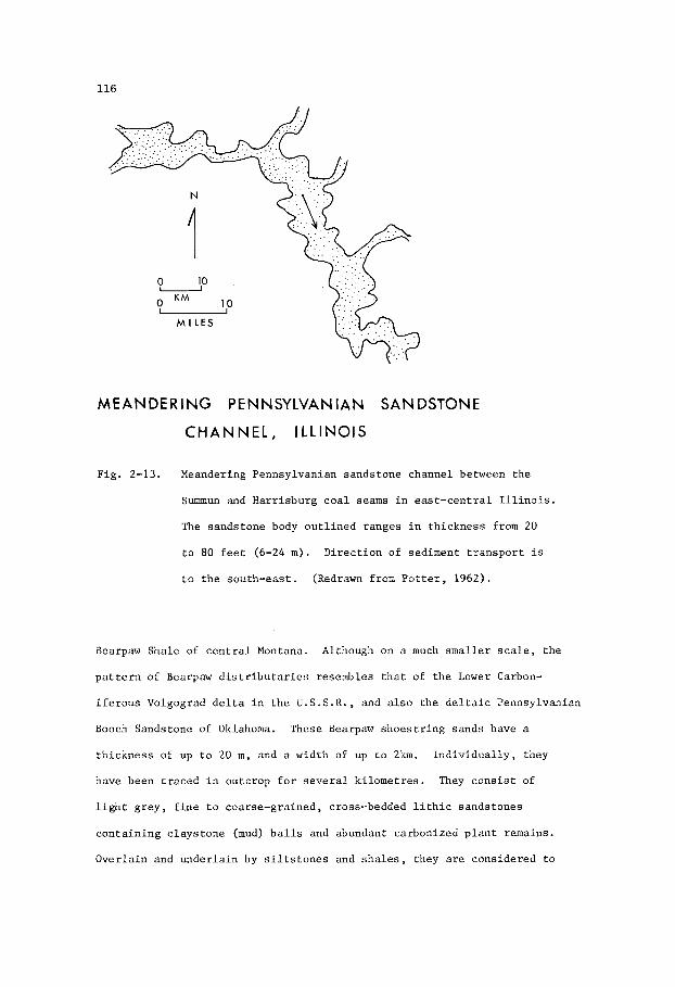
116
MEANDERING PENNSYLVANIAN SANDSTONE
CHANNEL, I LLlNOlS
Fig. 2-13. Meandering Pennsylvanian sandstone channel between the
Summun and Harr isburg c o a l seams i n e a s t - c e n t r a l I l l i n o i s .
The sandstone body o u t l i n e d ranges i n th i ckness from 20
t o 80 f e e t (6-24 m). D i rec t ion of sediment t r a n s p o r t i s
t o t h e south-east . (Redrawn from P o t t e r , 1962).
Bearpaw Shale of c e n t r a l Montana.
p a t t e r n of Bearpaw d i s t r i b u t a r i e s resembles t h a t of t h e Lower Carbon-
i f e r o u s Volgograd d e l t a i n t h e U.S .S .R. , and a l s o t h e d e l t a i c Pennsylvanian
Booch Sandstone of Oklahoma. These Bearpaw s h o e s t r i n g sands have a
th i ckness of up t o 20 m, and a width of up t o 2km. I n d i v i d u a l l y , they
have been t r a c e d i n outcrop f o r s e v e r a l k i lome t re s . They c o n s i s t of
l i g h t g rey , f i n e t o coarse-grained, cross-bedded l i t h i c sandstones
con ta in ing c l ays tone (mud) b a l l s and abundant carbonized p l a n t remains.
Overlain and unde r l a in by s i l t s t o n e s and s h a l e s , they are considered t o
Although on a much smaller s c a l e , t he

117
R 21 E R 2 2 E
0 M I L E S 5 1 I
Fig . 2-14. D i s t r i b u t i o n of s h o e s t r i n g sands tone bod ies formed a s
channels i n t h e n e a r l y f l a t - l y i n g Upper Cretaceous Bearpaw
Sha le , c e n t r a l Montana. (Af t e r Wulf, 1964) .
be d i s t r i b u t a r i e s formed on p a r t of a Bearpaw delta-complex t h a t
prograded eas tward .
The area shown i n F ig . 2-14 o v e r l i e s t h e Lake Basin o i l and gas
f i e l d , a s t r u c t u r a l dome. I n t h e subsu r face , t h e p a t t e r n of Bearpaw
s h o e s t r i n g sands now cropping o u t could form p o t e n t i a l s t r u c t u r a l -
- s t r a t i g r a p h i c t r a p s f o r hydrocarbons.
O i l and Gas F i e l d s . - The fo l lowing examples of o i l and gas f i e l d s i n d i s t r i b u t a r y and
d e l t a - f r i n g e sand bod ies range i n age from Late Pa leozo ic t o Middle
Cenozoic. Of t h e s e , f o u r are Pennys lvanian , two are M i s s i s s i p p i a n ,

118
t h r e e a r e Cre taceous , and f o u r are T e r t i a r y . E igh t examples a r e i n
t h e U . S . A . , two i n Canada, and one each i n Venezuela, N i g e r i a , and
t h e U.S.S.E. This d i s t r i b u t i o n is n o t p re sen ted as be ing r e p r e s e n t a t i v e
of t h e world o r of Xorth America, as i t i s obvious ly b i a sed by a ve ry
l i m i t e d sampling.
Booch Sandstone O i l F i e l d s , Oklahoma
The Ea r ly Pennsylvanian Booch Sandstone of t h e 14cAlester Formation
i n Oklahoma (Fig . 2-15) forms a branching sys tem of d i s t r i b u t a r y shoe-
- s t r i n g sands t h a t cover an a r e a a t least 112 km wide. Flowing t o t h e
s o u t h , t h i s d i s t r i b u t a r y sys tem comprised a c e n t r a l main channel , i n
which sand bod ies more than 60 m t h i c k w e r e d e p o s i t e d , and a l s o secondary
channels which commonly conta ined sand bod ies less than 30 m t h i c k .
F ig . 2-15 shows t h e g e n e r a l i z e d p a t t e r n formed by t h e composite d i s t r i b -
u t i o n of t h e s e sand bod ies . In t h e n o r t h e a s t e r n p a r t of t h e a r e a , t h e
upper sands tone member of t h e Booch Sandstone i s t h e predominant u n i t ,
whereas i n t h e southwes tern p a r t t h e Booch Sandstone i s r ep resen ted by
members lower i n t h e sequence. Busch (1971) s a y s t h a t t h e Booch d i s t -
r i b u t a r i e s were formed on a l a r g e delta-complex t h a t covered an area of
approximate ly 5120 s q . km w i t h i n t h e Arkoma Basin. It i s i n t e r e s t i n g
t o n o t e t h a t t h e present-day conf igu ra t ion of composite channels w i t h i n
t h e d e l t a of t h e Rio Grande R ive r , Texas, is comparable i n s i z e and
shape t o t h a t of t h e Booch Sandstone (F ig . 2-15). The Booch Sandstone
i s commonly very f ine-gra ined and l i t h i c , w i th a f a i r l y h igh (ave. 15%)
con ten t of c l a y . Pe rmeab i l i t y improves where, l o c a l l y , t h e sands tone i s
medium t o coarse-gra ined .
There a r e numerous o i l f i e l d s producing from t h e Booch Sandstone,
most of which are n o t i n t h e t h i c k e r main channel bu t i n t h e t h i n n e r
d i s t r i b u t a r i e s . Many of t h e s e a r e pu re ly s t r a t i g r a p h i c t r a p s , t he

119
OIL FIELDS IN PENNSYLVANIAN BOOCH SANDSTONE OKLAHOM
RIO GRANDE DELTA, TEXAS
Fig . 2-15. Upper - Map showing composite d i s t r i b u t i o n of t h e Booch
Sandstone member i n t h e Pennsylvanian McAlester
Formation, Seminole d i s t r i c t , Oklahoma.
f i e l d s , where p roduc t ion is obta ined from t h e Booch,
are shown i n b l ack . (Redrawn from Dicky and Rohn,
1958, a f t e r Br;sch, 1953; Busch, 1971).
Numerous o i l
Lower - Map showing present-day d i s t r i b u t a r y channels on t h e
d e l t a of t h e Rio Grande R ive r , Texas. This d e l t a
h a s grown a c r o s s t h e lagoon where i t s ex tens ion i s
c u r r e n t l y l i m i t e d by wave and c u r r e n t a c t i o n t h a t
forms t h e b a r r i e r i s l a n d . Con t inua l ly changing cour se ,
t h e d i s t r i b u t a r y channels b u i l d up a complex p a t t e r n
of s inuous s h o e s t r i n g sands . Same s c a l e as above.

120
14
4
4
0 23
.
26

121
o i l be ing conf ined by pe rmeab i l i t y b a r r i e r s where t h e sands tone p inches
out and is f l anked by s h a l e s and s i l t s t o n e s which o r i g i n a t e d as sediments
depos i ted i n a backswamp environment between t h e d i s t r i b u t a r i e s . Others
have a s t r u c t u r a l i n f l u e n c e where westward-plunging noses i n t e r s e c t more
permeable sands tone zones w i t h i n t h e d i s t r i b u t a r y t r ends .
The Hawkins O i l F i e l d , l o c a t e d a t t h e southwes tern ex t r emi ty of t h e
Booch d e l t a ( see i n s e t i n F ig . 2-15), produces from thP Booch Sandstone
shown i n Fig. 2-16. This f i g u r e i s an i sopach map of a member comprising
d i s t r i b u t a r y sand bod ies s i t u a t e d i n t h e middle of t h e Booch s t r a t i g r a p h i c
i n t e r v a l . 'This o i l -bea r ing sands tone member w a s depos i t ed i n a main nor th-
-south t r end ing d i s t r i b u t a r y channel t h a t branched t o t h e south-eas t and
south-west. The maximum th i ckness of sands tone i n t h e main channel is
-1itrapment of o i l has r e s u l t e d from the co inc idence of t h e s e 10 m.
s h o e s t r i n g sands and a s t r u c t u r a l "high" t h a t has r e s u l t e d from compaction.
Busch (1971) shows t h a t r a t e s of p roduc t ion co inc ide wi th t r e n d s of maximum
sands tone t h i c k n e s s , t h e o i l y i e l d be ing g r e a t e r where t h e sands tone i s
t h i c k e r .
South P ine Hollow Gas F i e l d , Oklahoma
In t h e South P ine Hollow Gas F i e l d (F ig . 2-17) of Oklahoma t h e
producing u n i t i s t h e Ea r ly Pennsylvanian Lower Har t shorne Sandstone.
This s ands tone , which is t h e b a s a l u n i t of t h e Desmoinesian S tage , i s
Fig . 2-16. I sopach map of t h e o i l -bea r ing middle member of t h e Booch
Sandstone i n t h e Pennsylvanian McAlester Formation, Oklahoma.
The a r e a shown covers t h e Hawkins O i l F i e l d . Sca le of g r i d
i n squa re m i l e s (1 m i l e = 1 . 6 km).
5 f e e t (1.5 m). (Af t e r Busch, 1971).
Contours show i n t e r v a l s of
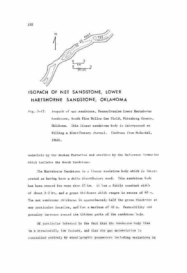
122
ISOPACH OF N E T SANDSTONE, LOWER
HARTSHORNE SANDSTONE, OKLAHOMA
Fig . 2-17. Isopach of n e t s ands tone , Pennsylvanian Lower Har t shorne
Sands tone , South P ine Hollow Gas F i e l d , P i t t s b u r g County,
Oklahoma. This l i n e a r s ands tone body is i n t e r p r e t e d as
f i l l i n g a d i s t r i b u t a r y channel .
1968).
(Redrawn from McDaniel,
unde r l a in by t h e Atokan Formation and o v e r l i a n by t h e HcAles te r Formation
which i n c l u d e s t h e Booch Sandstone.
The Har tshorne Sandstone is a l i n e a r sands tone body which i s i n t e r -
p r e t e d as having been a d e l t a d i s t r i b u t a r y sand.
has been t r a c e d f o r more than 25 km. It has a f a i r l y cons t an t wid th
of about 2-3 km, and a g ross th i ckness which ranges i n excess of 60 m.
The n e t sands tone th i ckness is approximately h a l f t h e g r o s s th i ckness a t
any p a r t i c u l a r l o c a t i o n , and has a maximum of 40 m.
p o r o s i t y i n c r e a s e toward t h e t h i c k e r p a r t s of t h e sands tone body.
This sands tone body
Pe rmeab i l i t y and
O f p a r t i c u l a r i n t e r e s t i s t h e f a c t t h a t t h e sands tone body l i e s
i n a s t r u c t u r a l l y low f e a t u r e , and t h a t t h e gas accumulation i s
c o n t r o l l e d e n t i r e l y by s t r a t i g r a p h i c parameters i n c l u d i n g v a r i a t i o n s i n
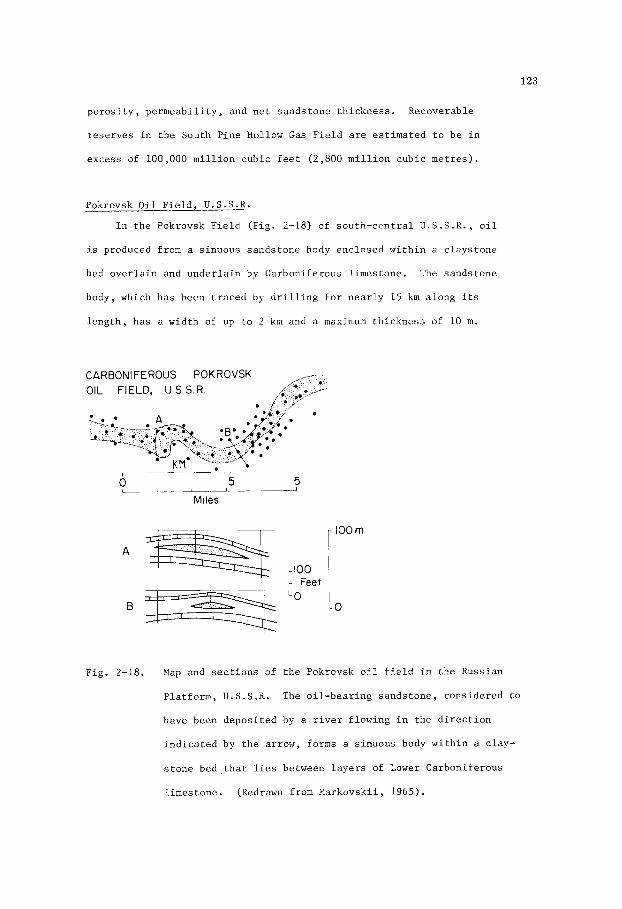
123
p o r o s i t y , pe rmeab i l i t y , and n e t sands tone th i ckness . Recoverable
r e se rves i n t h e South P ine Hollow G a s F i e l d are es t ima ted t o be i n
excess of 100,000 m i l l i o n cubic f e e t (2,800 m i l l i o n cub ic me t re s ) .
Pokrovsk O i l F i e l d , U . S . S . R .
I n t h e Pokrovsk F i e l d (F ig . 2-18) of sou th -cen t r a l U . S . S . R . , o i l
i s produced from a s inuous sands tone body enc losed w i t h i n a c l ays tone
bed o v e r l a i n and u n d e r l a i n by Carboni ferous l imes tone . The sands tone
body, which has been t r a c e d by d r i l l i n g f o r n e a r l y 15 krn a long i t s
l e n g t h , has a wid th of up t o 2 kn and a maxirr.um th i ckness of 10 m.
CARBONIFEROUS POKROVSK OIL FIELD, U S S R
Fig. 2-18. Map and s e c t i o n s of t h e Pokrovsk o i l f i e l d i n t h e Russian
P la t fo rm, U.S.S.R. The o i l -bea r ing sands tone , cons idered t o
have been depos i t ed by a r i v e r f lowing i n t h e d i r e c t i o n
i n d i c a t e d by t h e a r row, forms a s inuous body w i t h i n a c lay-
s t o n e bed t h a t l i e s between l a y e r s of Lower Carboni ferous
l imes tone . (Redrawn from Markovskii , 1965).
124
The sands tone i s cons idered t o have been a c h a n n e l - f i l l sand
depos i t ed by a d i s t r i b u t a r y f lowing over a f l a t c o a s t a l p l a i n du r ing
a pe r iod of l i m i t e d emergence of t h e l and preceded and fo l lowed by
t h e development of carbonate s h o a l s . The sands tone i s q u a r t z o s e , f i n e
t o medium-grained, and w e l l s o r t e d . The mean p o r o s i t y i s 20% and t h e
p e r m e a b i l i t y , which i s g e n e r a l l y good, i n c r e a s e s i n t h e c e n t r a l p a r t s
of t h e body where t h e sands tone is t h i c k e r and c o a r s e r . The p a t t e r n of
h o l e s sugges t s t h a t o i l accumulation i n t h e f i e l d is c o n t r o l l e d e s sen t -
i a l l y by s t r a t i g r a p h i c f e a t u r e s r e l a t e d t o t h e d i s t r i b u t i o n of t h e
sands tone body, and t h a t e x p l o r a t i o n proceeded on a h i t -or -miss b a s i s .
Eas t Tuskegee O i l F i e l d , Oklahoma
The Misener Sandstone i s one of t h e main producing members i n t h e
Eas t Tuskegee F i e l d of Oklahoma, y i e l d i n g o i l having a g r a v i t y of 39O
A . P . I . This sands tone unconformably o v e r l i e s t h e Ordovic ian and i s
conformably o v e r l a i n by t h e Ea r ly H i s s i s s i p p i a n Chattanooga Shale which i s
a very widespread , d iachronous u n i t . The uppermost p a r t of t h e Misener
Sandstone i s composed mainly of angu la r t o rounded g r a i n s of q u a r t z , and
c o n t a i n s conodonts and phospha t i c g a s t r d i t h s (Borden and Bran t , 1941).
The lower p a r t is coarse-gra ined , commonly g r i t t y , and qua r t zose wi th
abundant g r a i n s of c h e r t .
The o r i g i n of t h e Hisener Sandstone has been t h e s u g j e c t of cont-
rove r sy . White (1928) was of t h e op in ion t h a t t h e sands tone was e o l i a n ,
whereas Borden and Brant (1941) concluded t h a t t h e sands tone was depos i ted
nea r s h o r e i n a marine environment. The s t r a t i g r a p h i c p o s i t i o n of t h e
sands tone , l y i n g d i r e c t l y on an unconformity, and t h e coa r se n a t u r e of
t h e lower s e c t i o n sugges t a f l u v i a l o r i g i n f o r t h e lowermost p a r t . When
t h e Misener was depos i t ed t h e l and must have been very f l a t and nea r
s e a l e v e l t o a l low e x t e n s i v e t r a n s g r e s s i o n of t h e s e a i n Chattanooga

125
t i m e . It i s no t s u r p r i s i n g t h e n , t h a t t h e upper p a r t of t h e Misener
should c o n t a i n a marine fauna . The p a t t e r n of d i s t r i b u t i o n and th i ck -
ness of t h e Misener , as shown i n F ig . 2-19, nay r ep resen t a composite
p i c t u r e of a d i s t r i b u t a r y sand body t h a t has been re-worked i n t h e upper
p a r t by a t r a n s g r e s s i n g s e a , p o s s i b l y i n an e s t u a r i n e environment.
GEOMETRY OF MISENER SANDSTONE, EAST
TUSKEGEE OIL FIELD, OKLAHOMA
Fig. 2-19. I sopach map of Miss i s s ipp ian Misener Sandstone, E a s t Tuskegee
O i l Fi .eld, Creek County, Oklahoma. (Redrawn from Borden and
Bran t , 1941) .

126
Dale Consol ida ted O i l F i e l d , I l l i n o i s
In t h e Dale Consol ida ted F i e l d of I l l i n o i s , o i l p roduc t ion i s
ob ta ined from t h e Upper Miss i s s ipp ian Hardinsburg Sandstone, one of
s e v e r a l hydrocarbon-bearing sands tone u n i t s i n t h e Ches t e r S e r i e s ( see
F ig . 2-12). F ig . 2-20 i l l u s t r a t e s t h e sha rp e r o s i o n a l c o n t a c t of t h e
Hardinsburg Sandstone wi th t h e under ly ing beds , and t h e upward decrease
of mean g r a i n s i z e i n t h e upper p a r t of t h e Hardinsburg. These cha rac t -
e r i s t i c s a r e t y p i a a l of sands tone u n i t s i n t h e Ches t e r and are i n d i c a t i v e
of t h e i r o r i g i n a s c h a n n e l - f i l l sands . The use of a c l o s e l y under ly ing
l imes tone marker as a datum r e s t o r e s t h e o r i g i n a l c o n f i g u r a t i o n of t h e
channel and s u g g e s t s t h a t when t h e channel w a s i n i t i a l l y f i l l e d wi th
c o a r s e r s and , c h a r a c t e r i z e d by t h e b locky s e l f - p o t e n t i a l E-log cu rve ,
t h e l imes tone marker and o t h e r beds under ly ing t h e e r o s i o n a l channel had
a low r e g i o n a l d ip .
1 0 MILE L I
0 KM 1
Fig . 2-20. S t r a t i g r a p h i c s e c t i o n of channel f i l l e d wi th Upper Miss i s s ipp ian
Hardinsburg Sandstone, Dale Consol ida ted o i l f i e l d , Hamilton
County, I l l i n o i s . Datum i s a l imes tone bed. (Redrawn from
P o t t e r e t aZ., 1958).

127
The Hardinsburg Sandstone and o t h e r s ands tone u n i t s of t h e Ches te r
a r e cons idered by P o t t e r e t aZ.
- e x i s t i n g sed iments , as they are q u a r t z a r e n i t e s composed almost e n t i r e l y
of moderately well-rounded g r a i n s . I n d i c a t i v e of t h e i r o r i g i n as
c h a n n e l - f i l l s ands , t h e s e sands tone u n i t s commonly show f l u v i a l - t y p e
cross-bedding. Also i n d i c a t i v e of t h e i r d e p o s i t i o n a l environment i s
t h e i r s t r a t i g r a p h i c r e l a t i o n s h i p wi th t h i n c o a l seams, which sugges t
t h a t t h e channels meandered ove r a marshy d e l t a i c p l a i n .
(1958) t o have been de r ived from pre-
B e l l s h i l l Lake O i l F i e l d , A lbe r t a
The B e l l s h i l l Lake F i e l d of e a s t - c e n t r a l A l b e r t a produces o i l from
the E l l e r s l i e Sands tone , t h e b a s a l u n i t of t h e Lower Cre taceous B la i r -
more Group. The E l l e r s l i e , which f i l l s a broad ,eas t -wes t t r end ing v a l l e y
(F igs . 1-41, 1-42) on t h e eroded s u r f a c e of t h e Devonian ca rbona te s , is
composed of qua r t zose sands tone de r ived from Precambrian rocks . F luv ia l -
type cross-bedding i s a common f e a t u r e , i n d i c a t i n g t h a t t h e El lers l ie was
depos i t ed by a r i v e r . Pa leogeographic r e c o n s t r u c t i o n (Conybeare, 1972)
sugges t s t h a t t h i s r i v e r flowed eas tward from t h e Precambrian Sh ie ld t o
a Lower Cre taceous sea t r a n s g r e s s i n g southward. T ransg res s ion subsequent ly
r e s u l t e d i n drowning t h e E l le rs l ie r i v e r sys tem, t h e sands of which are
o v e r l a i n by e s t u a r i n e , c o a s t a l marsh, and b r a c k i s h t o f resh-water
l a c u s t r i n e sed iments .
F ig . 2-21 i l l u s t r a t e s a p o r t i o n of a sha l low stream channel t h a t
meandered on a c o a s t a l p l a i n ove r ly ing t h e E l l e r s l i e r i v e r sand a t
B e l l s h i l l Lake O i l F i e l d . In t h i s c a s e , hydrocarbon accumulation i n
t h e meandering sand body i s n o t s i g n i f i c a n t w i th r e spec t t o p roduc t ion
from t h e E l l e r s l i e , b u t where such an a r c u a t e body is t h i c k e r and convex
up-dip, i t may form an e x c e l l e n t s t r a t i g r a p h i c t r a p . A s i m i l a r example
(Fig. 1-43) i s i l l u s t r a t e d by Mar t in (1966) who s t a t e s t h a t i n t h e

1 2 8
0
E l
u 0 KM I ! I
MILE
- IOOFEET
ISOPACH M A P OF MANNVILLE SANDSTONE 'A, BELLSHILL LAKE FIELD, ALBERTA.
F i g . 2-21. Upper - I sopach map of a t h i n s a n d s t o n e 'A' i n t h e lower p a r t
of the B l a i n o r e Group, B e l l s h i l l Lake F i e l d , A l b e r t a .
T h i s s a n d s t o n e w a s d e p o s i t e d as a stream meander on a
c o a s t a l p l a i n .
Lower - E l e c t r i c l o g showing t h e r e l a t i o n s h i p of s a n d s t o n e 'A'
t o t h e o i l - p r o d u c i n g b a s a l q u a r t z s a n d s t o n e (B) of t h e
E l le rs l ie Format ion i n t h e B e l l s h i l l Lake F i e l d .
Hughenden F i e l d , which a l s o produces from t h e E l l e r s l i e , o i l is t r a p p e d
w i t h i n t h e E l l e r s l i e a g a i n s t a c l a y - f i l l e d meander t h a t i n t e r s e c t s t h e
r e g i o n a l s t r i k e . Both examples r e q u i r e a c l o s u r e formed by t h e co in-
c i d e n c e of a meander l o o p and r e g i o n a l d i p : b u t i n F i q . 2 2 1 %he t r a p IS
129
a s a n d - f i l l e d loop , whereas i n M a r t i n ' s example t h e t r a p i s w i t h i n a
s a n d - f i l l e d loop of t h e E l l e r s l i e where i t is l o c a l l y s e a l e d by a younger
c l a y - f i l l e d loop .
Conybeare (1972), Swindon (1968), Berg (1968) and Truchot (1963).
Other examples of a s i m i l a r n a t u r e a r e i l l u s t r a t e d by
The Ellerslie Sandstone is cross-bedded, qua r t zose , f i n e t o coarse-
-gra ined and up t o 75 m t h i c k . It h a s v a r i a b l e p o r o s i t y and pe rmeab i l i t y ,
i n p a r t determined by l o c a l cementa t ion w i t h c a l c i t e and c l a y mine ra l s .
In t h e B e l l s h i l l Lake F i e l d t h e p o r o s i t y and pe rmeab i l i t y a r e commonly i n
t h e range 25-28% and 1,000-1,500 m i l l i d a r c y s r e s p e c t i v e l y , t h e l a t t e r
ranging up t o 6,000 b u t averaging 600 m i l l i d a r c y s . Product ion problems
d e r i v e mainly from an e f f e c t i v e water d r i v e t h a t invades t h e o i l -bea r ing
zone. The o i l has a g r a v i t y of 280 A . P . I . and a gas con ten t of approx-
imate ly 150 cub ic f e e t p e r b a r r e l of oil. (approximately 20 cub ic metres
of gas pe r cub ic metre of o i l ) . The e s t ima ted o i l i n p l a c e i s approx-
imate ly 180 m i l l i o n b a r r e l s (28.6 m i l l i o n cubic m e t r e s ) , b u t water d r i v e
problems p rec lude t h e p roduc t ion of ve ry l i t t l e more than 36 m i l l i o n
b a r r e l s (5 .7 m i l l i o n cub ic m e t r e s ) .
B e l l y River P o o l , Pembina O i l F i e l d , A lbe r t a
I n t h e Pembina F i e l d of wes t - cen t r a l A l b e r t a , t h e main o i l p roduct ion
comes from t h e Upper Cre taceous Cardium Sands tone , approximate ly 300 m
below t h e b a s a l sands tone number of t h e Upper Cretaceous Be l ly River
Formation. Add i t iona l p roduc t ion i s ob ta ined from t h e Be l ly River P o o l
which y i e l d s o i l from t h i s b a s a l sands tone member.
sequence of marine s h a l e s of t h e Upper Cretaceous Lea Park Formation, t h e
b a s a l member of t h e Be l ly River i s found throughout a wide a r e a . It is
diachxonous and c o n s i s t s of two o r more g e n e t i c u n i t s . One of t h e s e u n i t s
i s a marine s h o r e l i n e sand , another i s a sand t h a t f i l l s channels c u t
i n t o t h e marine sand by d i s t r i b u t a r i e s of t h e eas tward prograding Bel ly
Overlying a t h i c k

130
CRETACEOUS BELLY RIVER SANDSTONE, PEMSINA
OIL FIELD, ALBERTA
BUCK CREEK 14-30 A1
Fig . 2-22. Map and s t r a t i g r a p h i c s e c t i o n A - A 1 showing d e p o s i t i o n a l
t r e n d s of t h e b a s a l sands tones of t h e Upper Cretaceous Bel ly
River Formation, Pembina F i e l d , A lbe r t a .
d i s t r i b u t a r y sands ( s t i p p l e d ) c u t t i n g a c r o s s a mar ine s h o r e l i n e
sand (ha tchured ) . The s t i p p l e d and ha tchured a r e a s a l s o
i n d i c a t e where t h e sands tones are more than 30 f e e t t h i c k .
The arrow shows t h e approximate d i r e c t i o n of r e g i o n a l d ip .
The s e c t i o n shows coa r se t o medium sand (1) f i l l i n g t h e lower
p a r t of a channel o v e r l a i n by f i n e sand ( 2 ) .
is i n t u r n o v e r l a i n by s i l t s and a c o a l seam.
1944, 1972).
The map shows r i v e r
This f i n e sand
(Af te r Conybeare,

131
River d e l t a . The marine sand is g e n e r a l l y f ine -g ra ined , w i t h poor
po ros i ty and pe rmeab i l i t y , whereas t h e channel sands are c o a r s e r and
more permeable. The Bel ly River P o o l i s conta ined w i t h i n one of t h e s e
channels (F ig . 2-22).
The producing sands tone i s l i t h i c , c o n s i s t i n g of g r a i n s of q u a r t z ,
q u a r t z i t e , c h e r t , f e l d s p a r , a r g i l l i t e , and v o l c a n i c rocks de r ived from
a wes tern sou rce . The sands tone grades from coa r se t o medium a t t h e
base t o f i n e a t t h e top .
t he sands tone . Within t h e channel , which i s about 2 km i n wid th , t h e
maximum t h i c k n e s s of s ands tone i s 20 m . The maximum t h i c k n e s s of t h e
o i l -bea r ing zone is 10 m. P o r o s i t y averages 18% and pe rmeab i l i t y is f a i r
bu t v a r i a b l e . The poo l is pure ly s t r a t i g r a p h i c , o i l be ing con ta ined
w i t h i n t h e t h i c k e r and c o a r s e r p a r t s of t h e sands tone where i t i s t r apped
by pe rmeab i l i t y b a r r i e r s on t h e f l a n k s of t h e channel .
Mudstone, c o n t a i n i n g a t h i n c o a l seam, o v e r l i e s
The Be l ly River Pool i s e s t ima ted t o c o n t a i n more than 30 m i l l i o n
(4 .8 m i l l i o n cub ic me t re s ) of 36O A . P . I . o i l , bu t r ecove rab le r e s e r v e s
a r e e s t ima ted a t only 2 m i l l i o n b a r r e l s (0 .2 m i l l i o n cub ic me t re s ) .
Gas s o l u t i o n d r i v e i s t h e main producing mechanism, t h e i n i t i a l gas con ten t
of t h e o i l amounting t o 350 cub ic f e e t per b a r r e l of o i l (approximately 50
cubic metres of gas pe r cub ic metre of o i l ) .
a r e 25-30 b a r r e l s a day pe r well.
Allowable p roduc t ion rates
Af ie se re and Eriemu O i l F i e l d s , N ige r i a
The o i l -producing sands tones i n t h e A f i e s e r e and Eriemu O i l F i e l d s
(Fig. 2-23) of t h e Niger Delta, N i g e r i a , o r i g i n a t e d a s a L a t e Cretaceous
t o Pa leocene complex of b a r r i e r b a r and d e l t a d i s t r i b u t a r y sands.
t h i s p a r a l i c environment, t h e complex of sand bod ies developed i n a
c y c l i c a l sequence of o f f - l app ing sed imentary beds , g rad ing upward from
marine c l a y s t o f luv iomar ine , i n t e r l a m i n a t e d s i l t s and sands o v e r l a i n
I n
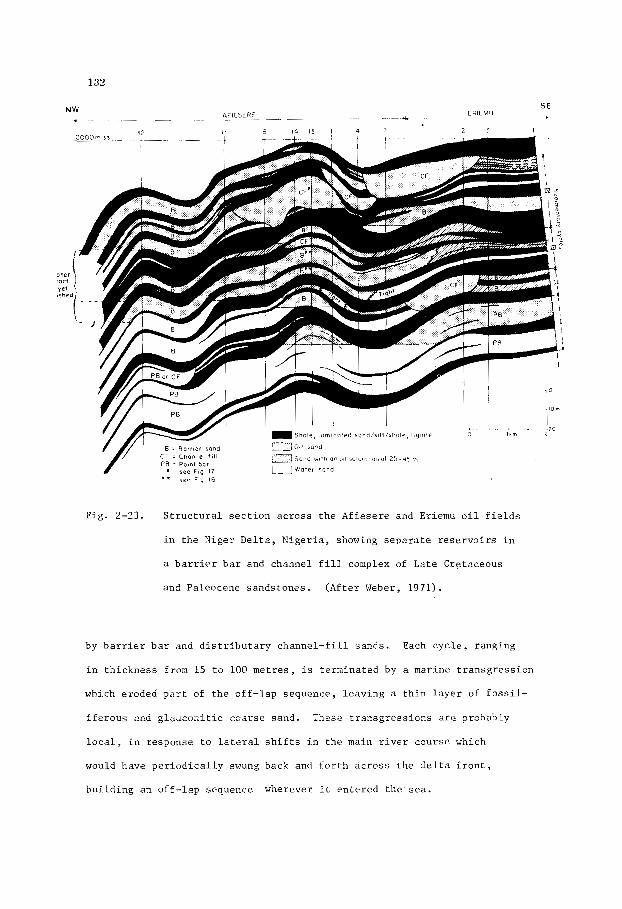
132
Fig . 2-23. S t r u c t u r a l s e c t i o n ac ross t h e A f i e s e r e and Eriemu o i l f i e l d s
i n t h e Niger Delta, N ige r i a , showing s e p a r a t e r e s e r v o i r s i n
a b a m i e r b a r and channel f i l l complex of Late Cretaceous
and Paleocene sands tones . (Af t e r Weber, 1 9 7 1 ) .
by b a r r i e r b a r and d i s t r i b u t a r y c h a n n e l - f i l l sands .
i n t h i c k n e s s from 15 t o 100 metres, is te rmina ted by a marine t r a n s g r e s s i o n
which e roded p a r t of t h e o f f - l a p sequence , l e a v i n g a t h i n l a y e r of f o s s i l -
i f e r o u s and g l a u c o n i t i c coa r se sand.
l o c a l , i n response t o l a t e r a l s h i f t s i n t h e main r i v e r course which
would have p e r i o d i c a l l y swung back and f o r t h a c r o s s t h e d e l t a f r o n t ,
b u i l d i n g an o f f - l ap sequence
Each c y c l e , ranging
These t r a n s g r e s s i o n s a r e probably
wherever i t en te red t h e sea.
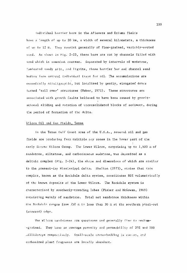
133
I n d i v i d u a l b a r r i e r b a r s i n t h e A f i e s e r e and Eriumu f i e l d s
have a l e n g t h of up t o 20 km, a wid th of s e v e r a l k i l o m e t e r s , a th i ckness
of up t o 1 2 m . They c o n s i s t g e n e r a l l y of f ine -g ra ined , va r i ab ly - so r t ed
sand. A s shown i n F ig . 2-23, t h e s e b a r s a r e c u t by channels f i l l e d wi th
sand which i s somewhat c o a r s e r . Separa ted by i n t e r v a l s of mudstone,
laminated sandy s i l t , and l i g n i t e , t h e s e b a r r i e r b a r and channel sand
bodies form s e v e r a l i n d i v i d u a l t r a p s f o r o i l . The accumula t ions are
e s s e n t i a l l y s t r a t i g r a p h i c , bu t l o c a l i z e d by g e n t l y , e longa ted domes
termed ' r o l l ove r ' s t r u c t u r e s (Weber, 1971). These s t r u c c u r e s a r e
a s s o c i a t e d wi th growth f a u l t s be l i eved t o have been caused by g r a v i t -
a t i o n a l s l i d i n g and r o t a t i o n of unconsol ida ted b locks of sed iment , du r ing
t h e pe r iod of format ion of t h e d e l t a .
Wilcox O i l and Gas F i e l d s , Texas
In t h e Texas Gulf Coast a r e a of t h e U . S . A . , s e v e r a l o i l and gas
f i e l d s are oroducing from m u l t i p l e pay zones i n t h e lower p a r t o f t h e
Early Eocene Wilcox Group. The Lower Wilcox, comprising up t o 1,500 m of
s ands tone , s i l t s t o n e , and carbonaceous mudstone, was depos i t ed as a
d e l t a i c complex (F ig . 2-24), t h e shape and dimensions of which a r e s imi la r
t o t h e present-day M i s s i s s i p p i d e l t a . She l ton (1973), s t a t e s t h a t t h i s
complex, known as t h e Rockdale d e l t a sys tem, c o n s t i t u t e s 80% vo lumet r i ca l ly
of t h e known d e p o s i t s of t h e Lower Wilcox. The Rockdale system is
c h a r a c t e r i z e d by sou the r ly - t r end ing l o b e s ( F i s h e r and McGowan, 1969)
c o n s i s t i n g mainly o f sands tone . T o t a l n e t sands tone th i ckness w i t h i n
t h e Rockdale ranges from 750 m t o less than 30 m at t h e sou the rn pinch-out
(seaward) edge.
The Wilcox sands tones are qua r t zose and g e n e r a l l y f i n e t o medium-
-gra ined . They have an average p o r o s i t y and pe rmeab i l i t y of 20% and 100
m i l l i d a r c y s r e s p e c t i v e l y . Smal l - sca le cross-bedding is common, and
carbonized p l a n t f ragments are l o c a l l y abundant.
134
0 100 w
M I L E S 100
O w KM
EARLY E O C E N E D E P O S I T I O N A L S Y S T E M
Fig . 2 - 2 4 . Genera l ized d i s t r i b u t i o n o f t h e Lower Wilcox Group (Ear ly
Eocene) d e p o s i t i o n a l system, Texas. (Redrawn from F i she r
and McGowen, 1969) .
I n t e r f i n g e r i n g of p ro -de l t a muds w i t h b a r r i e r - b a r s ands , d i s t r i b u t a r y
c h a n n e l - f i l l s ands , and l i t t o r a l sands has provided numerous s e p a r a t e
r e s e r v o i r s s i m i l a r t o those of t h e Af i e se re and Eriemu f i e l d s of N ige r i a
(F ig . 2-23) . F i s h e r and McGowan (1969) s ta te t h a t l a r g e r f i e l d s i n t h i s
ca tegory i n c l u d e F a l l C i t y , Sher idan , Columbus, Lake Creek, New U l m , and
Quicksand Creek. Most f i e l d s i n t h e Lower Wilcox are e s s e n t i a l l y s t ra t i -
g raph ic , bu t l o c a l growth f a u l t s and d i a p i r i c s t r u c t u r e s , a s s o c i a t e d wi th
t h i c k e r p a r t s of t h e d e l t a l o b e s , co inc ide wi th s t r a t i g r a p h i c t r e n d s t o
form t r a p s .
See l ig son O i l F i e l d , Texas
One of t h e main o i l -bea r ing zones i n t h e See l ig son F i e l d of Texas
is t h e Oligocene Zone 19-b Sandstone. S i t u a t e d i n t h e Frio-Vicksburg

135
trelid of o i l f i e l d s , Zone 19-b forms an i r r e g u l a r , e a s t e r l y - t r e n d i n g
b e l t of sands tone t h a t has been t r a c e d a long i t s l e n g t h f o r 11 km, and
i s known t o have a wid th of 3-8 km. The geometry of t h i s sands tone
b e l t , which t r ends i n a d i r e c t i o n approximately normal t o t h e r eg iona l
d e p o s i t i o n a l s t r i k e of ad jacen t marine sands tone beds i n t h e Oligocene
sequence, sugges t s t h a t i t w a s formed by a branching r i v e r system on a
d e l t a p l a i n . In t h e See l ig son F i e l d a r e a t h r e e s u b s i d i a r y channels , 1,000-
2,000 m wide , b ranch from t h e main channel which h a s a wid th of 2,000-
2,000 m. An i sopach nap of Zone 19-b (F ig . 2-25 shows t h e main body of
t h e c h a n n e l - f i l l sands tone t o have a maximum th i ckness of more than 20 m ;
t he s u b s i d i a r y channels have a th i ckness i n t h e range 6-12 m.
The sands tone is predominantly l i t h i c . I t con ta ins fragments of
rock and f e l d s p a r , b u t i nc ludes up t o 50% q u a r t z , and 5-20% i n t e r s t i t i a l
s i l t and c l a y . Commonly we l l - so r t ed , and f i n e t o medium-grained, t h e
sands tone bod ies i n Zone 19-b show d i s t i n c t g r a i n g r a d a t i o n from c o a r s e r
below t o f i n e r above, a f e a t u r e c h a r a c t e r i s t i c of r i v e r d e p o s i t s . Sed i -
mentary s t r u c t u r e s commonly p r e s e n t i nc lude medium-scale cross-bedding
and c l ays tone fragments probably de r ived from t h e e r o s i o n of mud-cracked
c l ay a long t h e r i v e r banks. Var iab le p o r o s i t y and pe rmeab i l i t y sugges t
t h a t t h e o r i g i n a l composition of t h e sands tone v a r i e d from c lean sand t o
s i l t y and muddy sand. Local cementation by c a l c i t e and i l l i t e has a l s o
decreased p o r o s i t y and pe rmeab i l i t y .
O i l entrapment i n Zone 19-h has r e s u l t e d from t h e co inc idence of
permeable zones w i t h i n t h e d i s t r i b u t a r y channels and t h r e e g e n t l e domal
s t r u c t u r e s on t h e downthrow s i d e of a major normal f a u l t . Although t h e
Zone 19-b Sandstone h a s been a major c o n t r i b u t o r t o o i l p roduc t ion ,
s e v e r a l o t h e r zones i n the See l ig son F i e l d a r e p roduc t ive . She l ton
(1973, p. 30) s a y s , at See l igson F i e l d more than 40 sands , a l l of
vh ich a r e i r r e g u l a r l y developed, have combined wi th t h e s t r u c t u r a l
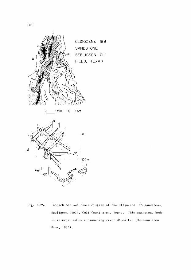
136
OLIGOCENE 196
S AN DS TONE
a' SEELIGSON OIL
I Mile 0-1 KM OU
Fig . 2-25. Isopach map and f ence diagram of t h e Oligocene 19B sands tone ,
See l ig son F i e l d , Gulf Coast a r e a , Texas. This sands tone body
is i n t e r p r e t e d a s a branching r i v e r d e p o s i t . (Redrawn from
Nanz, 1954).

137
p a t t e r n t o account f o r more than 140 i n d i v i d u a l r e s e r v o i r s . These sand
u n i t s are p r e s e n t i n a 1,500-foot s e c t i o n of Oligocene (or Hiocene)
F r io s t r a t a , which are cons idered non-marine i n o r ig in" .
Ostra O i l F i e l d , Venezuela
In t h e Ostra F i e l d , Venezuela (F ig . 2-26), o i l i s produced from
l e n t i c u l a r sands tone beds of t h e Oligocene Of ic ina Formation. These
sands tone beds are n o t only markedly l e n t i c u l a r , b u t a l s o r e l a t i v e l y
t h i n , commonly having a th i ckness of n o t more than 12 m , b u t l o c a l l y
ranging up t o 60 m. They o v e r l i e non-marine beds of t h e Oligocene
Mercure Formation and are cons idered t o be d e l t a d i s t r i b u t a r y channel l -
- f i l l sands and f r i n g i n g s h o r e l i n e sand d e p o s i t s . Young (1971, p . 250)
s a y s , "The sands tones a r e p a r t of a c y c l i c s e r i e s of s i l t s t o n e s , l i g n i t e s ,
s ands tones , s h a l e s and c l ays tone depos i t ed i n d e l t a i c and p a r a l i c environ-
ments through r ep rea t ed a l t e r n a t i o n of lagoonal-swamp, brackish-water and
shallow-wa te r marine cond i t ions ' I .
The sands tone l e n s e s a r e sepa ra t ed by s h a l e beds t h a t form an e f f e c t -
DATUM
krn L50m
CHANNEL SANDS, OSTRA FIELD, VENEZUELA.
Fig . 2-26. Sec t ion through o i l -bea r ing channel sands of t h e Oligocene
O f i c i n a Formation, Ostra F i e l d , Venezuela.
Young, 1971).
(Redrawn from
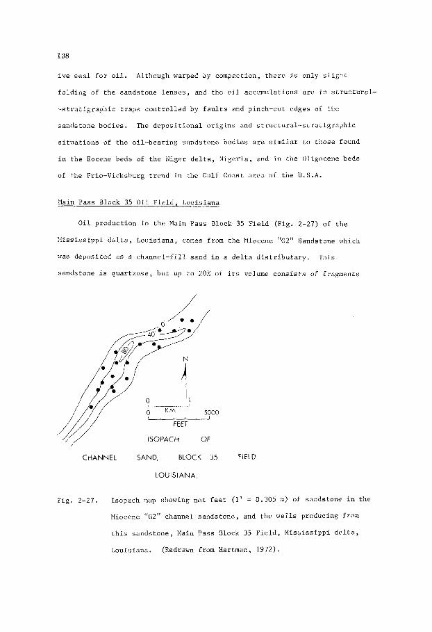
138
i v e seal f o r o i l . Although warped by compaction, t h e r e is only s l i g h t
f o l d i n g of t h e sands tone l e n s e s , and t h e o i l accumulations are i n s t r u c t u r a l -
- s t r a t i g r a p h i c t r a p s c o n t r o l l e d by f a u l t s and pinch-out edges of t h e
sands tone bod ies . The d e p o s i t i o n a l o r i g i n s and s t r u c t u r a l - s t r a t i g r a p h i c
s i t u a t i o n s of t h e o i l -bea r ing sands tone bod ies a r e s imi la r t o those found
i n t h e Eocene beds of t h e X g e r d e l t a , N i g e r i a , and i n t h e Oligocene beds
of t h e Frio-Vicksburg t r e n d i n t h e Gulf Coast a r e a of t h e U . S . A .
:.lain Pass Block 35 O i l F i e l d , Lou i s i ana
O i l p roduc t ion i n t h e Main Pass Block 35 F i e l d (F ig . 2-27) of t h e
? I i s s i s s i p p i d e l t a , Lou i s i ana , comes from t h e Miocene "GZ" Sandstone vh ich
was depos i t ed a s a c h a n n e l - f i l l sand i n a d e l t a d i s t r i b u t a r y .
sands tone is q u a r t z o s e , bu t up t o 20% of i ts volume c o n s i s t s of f ragments
This
/
ttt I
CHANNEL SAND, BLOCK 35 FIELD
LOUISIANA
Fig . 2-27. Isopach map showing n e t f e e t (1 ' = 0.305 m) of sands tone i n t h e
Miocene "G2" channel s ands tone , and t h e w e l l s producing from
t h i s s ands tone , Maln Pass Block 35 F i e l d , M i s s i s s i p p i d e l t a ,
Louis iana . (Redrawn from Nartman, 1972) .
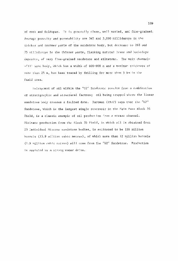
139
of rock and f e l d s p a r . It i s g e n e r a l l y c l e a n , w e l l s o r t e d , and f ine-gra ined .
Average p o r o s i t y and pe rmeab i l i t y a r e 34% and 3,000 m i l l i d a r c y s i n t h e
t h i c k e r and c o a r s e r p a r t s of t h e sands tone body, b u t dec rease t o 26% and
75 m i l l i d a r c y s i n t h e t h i n n e r p a r t s , f l a n k i n g n a t u r a l l evee and backs lope
d e p o s i t s , of very f ine-gra ined sands tone and s i l t s t o n e . The main channel-
- f i l l sand body, which has a wid th of 600-900 m and a maximum th i ckness of
more than 25 m , ha s been t r a c e d by d r i l l i n g f o r more than 5 km i n the
f i e l d a rea .
Entrapment of o i l w i t h i n t h e "G2" Sandstone r e s u l t s from a combination
of s t r a t i g r a p h i c and s t r u c t u r a l f a c t o r s ;
sands tone body c r o s s e s a f a u l t e d dome. Hartman (1972) says t h a t t h e "G2"
Sandstone, which i s t h e l a r g e s t s i n g l e r e s e r v o i r i n t h e Main Pass Block 35
F i e l d , is a c l a s s i c example of o i l p roduc t ion from a s t r eam channel.
U l t i m a t e p roduct ion from t h e Block 35 F i e l d , i n which o i l i s ob ta ined from
23 i n d i v i d u a l Miocene sands tone bod ies , is e s t ima ted t o be 100 m i l l i o n
b a r r e l s (15.9 m i l l i o n cubic m e t r e s ) , of which more than 12 m i l l i o n b a r r e l s
(1.9 m i l l i o n cub ic me t re s ) w i l l come from tile "G2" Sandstone. Product ion
i s a s s i s t e d by a s t r o n g wa te r d r i v e .
o i l be ing t rapped where t h e l i n e a r

This Page Intentionally Left Blank

141
Chapter 3
BARRIEA A;W OTHER OFFSHORE BARS
I n t r o d u c t i o n ___-
Geomorphology
B a r r i e r and o t h e r o f f s h o r e b a r s are l i n e a r sands tone bodies which
commonly have a th i ckness i n t h e range 5-15 m. Barrier b a r s a r e exposed
above sea l e v e l a s b a r r i e r i s l a n d s t h a t commonly form a cha in t r end ing f o r
many miles along t h e main c o a s t l i n e , s e p a r a t i n g l a soons and c o a s t a l bays
from t h e open s e a (F igs 3-1, 3--2). These i s l a n d s a r e commonly a m i l e o r
more wide and s e v e r a l m i l e s long . Other o f f s h o r e b a r s may develop w i t h i n
t h e o u t e r p a r t of a bay where t h e seaward edge of a sha l low-wa te r shoa l
s lopes downward i n t o deeper w a t e r , o r o f f a headland t o form a s p i t .
The seaward c o a s t of a b a r r i e r i s l a n d forms a nea r ly s t r a i g h t
t o g e n t l y curved f l a t beach washed by waves and c u r r e n t s t h a t winnow t h e
sand and t r a n s p o r t i t both seaward and along t h e c o a s t . The l azoona l
coas t of a b a r r i e r i s l a n d i s i r r e g u l a r , w i th numerous sma l l embayments
and c o a s t a l f l a t s of s i l t y sand and marsh. Other i s l a n d s t h a t rise from
o f f s h o r e b a r s w i t h i n a bay , o r t h a t forni s p i t s , commonly show t h e same
s h o r e l i n e c h a r a c t e r i s t i c s .
The a r e a exposed as i s l a n d s r e p r e s e n t s l e s s than h a l f t h e a r e a of
most sand b o d i e s , t h e seaward and landward o u t l i n e s of which are equa l ly
i r r e g u l a r as i n d i c a t e d by i sopach maps of bo th r ecen t (F ig . 3-5) and
anc ien t (F igs . 3-10, 3-14, 3-15, 3-18) b a r r i e r b a r s . Continuously s h i f t i n g ,
although no t n e c e s s a r i l y a t a cons t an t r a t e , t h e s e i s l a n d s t end t o mig ra t e
p a r a l l e l t o t h e main c o a s t l i n e , i n t h e d i r e c t i o n of t h e long-shore c u r r e n t
(Fig. 3-3).
t he sand be ing t r a n s p o r t e d along t h e o u t e r coas t and depos i t ed on t h e
The u p c u r r e n t end of each i s l a n d i s consequent ly e roded ,

142
0-20
0
I PADRE ISLAND, A BARRIER
GULF OF MEXICO
I S L A N D,
Fig . 3-1. Padre I s l a n d , a b a r r i e r i s l a n d of f t h e c o a s t of Texas, Gulf of
Mexico. Laguna Nadre l i e s between t h e b a r r i e r i s l a n d and t h e
mainland. (Redrawn from Rusnak, 1960).
L.
M I L F S
OFFSHORE BARS, LONG ISLAND, NEW YORK
Fig . 3-2. Offshore b a r s , Long I s l a n d , New York, showing t h e i r d i s t r i b -
u t i o n and geograph ica l r e l a t i o n s h i p s . Arrows show t h e long-
sho re c u r r e n t d i r e c t i o n s . (Lledrawn from Bass, 1934).

143
W T
MAINLAND E
1959 SHORELI
1890 SHORELINE
0 4 K M - MIGRATION OF TlMBALlER ISLAND,
GULF OF MEXICO.
Fig . 3-3. Shoreward and westward mig ra t ion of Timbal ie r I s l a n d ,
Lou i s i ana , du r ing t h e y e a r s 1890-1959, i n response t o nor th-
w e s t e r l y movement of c o a s t a l c u r r e n t s . '(Redrawn from Otvos,
1970) .
seaward ex tens ion of' beaches and a t t h e down-current end of t h e i s l a n d
where i t may form a s p i t . Wave a c t i o n moves t h e sand up t h e d e p o s i t i o n a l
s l o p e t o t h e beaches , except du r ing pe r iods of e x c e p t i o n a l l y h igh t i d e s
and heavy s torms when beaches a r e e roded and massive q u a n t i t i e s of sand
a r e t r a n s p o r t e d a long t h e c o a s t . Some sand i s swept i n l a n d over t h e
i s l a n d du r ing s torms , and some i s moved in l and a s sand dunes.
Unequal rates of e r o s i o n and d e p o s i t i o n , and v a r i a t i o n s i n t h e
rates of flow i n t i d a l channels between ad jacen t i s l a n d s , r e s u l t s i n
merging o r f u r t h e r s e p a r a t i o n of t h e i s l a n d s , a l though t h e scb-sea
d i s t r i b u t i o n of sand may form a s i n g l e sand body. I n some c a s e s , an
i s l a n d may s h i f t back t o a l o c a t i o n i t p rev ious ly occupied , so t h a t
a h o l e d r i l l e d through i t w i l l show two sand u n i t s s e p a r a t e d by s i l t -
s t o n e o r s h a l e . These sand u n i t s a r e commonly no t completely s e p a r a t e d ,
bu t merge l a t e r a l l y a c r o s s o r a long s t r i k e when viewed i n t h r e e
dimensions (F igs . 3-5, 3-1 8, 3-23).
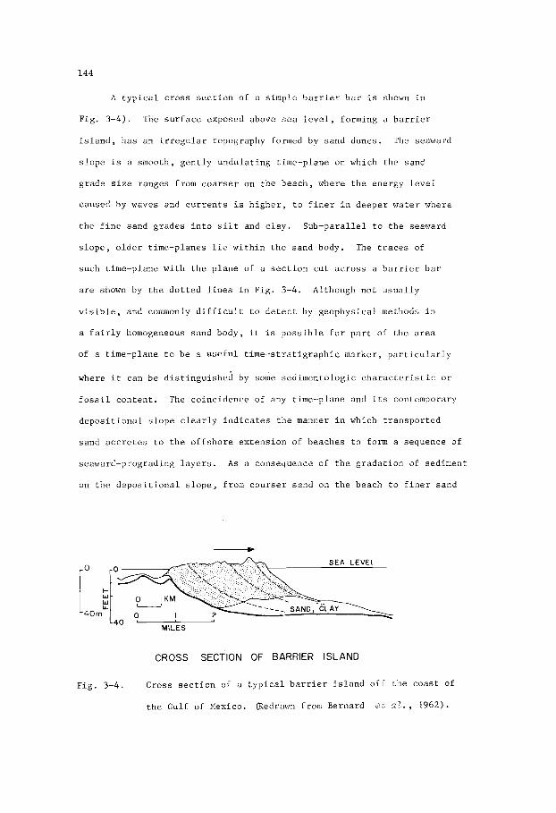
144
A t y p i c a l c ros s s e c t i o n of a s imple b a r r i e r b a r is shown i n
Fig. 3 - 4 ) . The s u r f a c e exposed above s e a l e v e l , forming a b a r r i e r
i s l a n d , h a s an i r r e g u l a r topography formed by sand dunes. The seaward
s l o p e is a smooth, g e n t l y undu la t ing t ime-plane on which t h e sand
grade s i z e ranges from c o a r s e r on t n e beach , where t h e energy l e v e l
caused by waves and c u r r e n t s i s h i g h e r , t o f i n e r in deepe r wa te r where
t h e f i n e sand grades i n t o s i l t and c l a y . Sub-para l le l t o t h e seaward
s l o p e , o l d e r t ime-planes l i e w i t h i n t h e sand body. The t r a c e s of
such t ime-plane wi th t h e p l ane of a s e c t i o n c u t a c r o s s a b a r r i e r b a r
a r e shown by t h e d o t t e d l i n e s i n F ig . 3-4. Although no t u s u a l l y
v i s i b l e , and commonly d i f f i c u l t t o d e t e c t by geophys ica l methods i n
a f a i r l y homogeneous sand body, i t is p o s s i b l e f o r p a r t of t h e a r e a
of a t ime-plane t o be a u s e f u l t i m e - s t r a t i g r a p h i c marker , p a r t i c u l a r l y
where i t can be d i s t i n g u i s h e d by some sedimento logic c h a r a c t e r i s t i c o r
f o s s i l con ten t . The co inc idence of any t ime-plane and i t s contemporary
d e p o s i t i o n a l s l o p e c l e a r l y i n d i c a t e s t h e manner i n which t r a n s p o r t e d
sand a c c r e t e s t o t h e o f f s h o r e ex tens ion of beaches t o form a sequence of
seaward-prograding l a y e r s . A s a consequence of t h e g r a d a t i o n of s e d i n e n t
on t h e d e p o s i t i o n a l s l o p e , from cour se r sand on t h e beach t o f i n e r sand
CROSS SECTION OF BARRIER ISLAND
Fig . 3 - 4 . Cross s e c t i o n of a t y p i c a l b a r r i e r i s l a n d o f f t h e coas t
t h e Gulf of Mexico. (Redrawn from Bernard et a l . , 1962
of

145
s i l t , and mud i n p rogres s ive ly deeper w a t e r , sand s i z e g r a d a t i o n w i t h i n
the sand body dec reases f r o top t o bottom, t h e r e v e r s e r e l a t i o n s h i p t o
c h a n n e l - f i l l r i v e r s ands .
Sands of b a r r i e r b a r s and o t h e r o f f s h o r e b a r s have a t e r r i g e n o u s
o r i g i n , having been t r a n s p o r t e d a long d i s t r i b u t a r i e s t o b a r - f i n g e r r
sand bodies then swept a long t h e c o a s t by c u r r e n t s and wave a c t i o n .
A t Grand Isle, Louis iana (F ig . 3 - 5 ) t h e sand i s f ine -g ra ined , l o c a l l y
s i l t y , and has a composition of approximate ly 80% q u a r t z and 20% f e l d s p a r .
Loca l ly , l e n t i c u l a r l a y e r s of g r i t o r pebbly sand may be p r e s e n t w i t h i n a
\ 1 ISOLITH OF SAND A
t 1 2 3
0 0- SEA LEVEL SAND A
S A N ~ ~
so'--
Fig . 3 - 5 . Eas te rn end of Grand I s l e , Lou i s i ana , showing c o n f i g u r a t i o n
of t h e i s l a n d , la teral e x t e n t of t h e upper Sand A ( i s o l i t h
contours i n f e e t ) , and a c ros s - sec t ion of t h e b a r r i e r i s l a n d
complex. (Redrawn from Cona t se r , 1971).

146
b a r r i e r b a r , having formed where some topographic f e a t u r e a long a beach
causes t h e sand t o be winnowed more v igo rous ly . Cross-bedding is a l s o
an i n t e r n a l f e a t u r e , b u t i n most ca ses i s of t h e low-angle type ( l e s s
than 10') i n c o n t r a s t t o t h e h i g h e r ang le of f l u y i a t i l e cross-bedding.
I n b a r r i e r and o t h e r b a r s t h e cross-bedding commonly r e f l e c t s changes
i n t h e d e p o s i t i o n a l s l o p e of an undu la t ing beach , bu t may a l s o r e s u l t
from c u r r e n t a c t i o n caused by t i d a l movements through channels between
b a r s . I n such channe l s , a high-angle type of cross-bedding, s i m i l a r t o
t h a t observed i n r i v e r p o i n t b a r s , may be developed. I n f a c t , t h e
r e l a t i o n s h i p s of cross-bedding t o t h e geometry of a b a r r i e r b a r t h a t i s
prograding i n t o a mig ra t ing t i d a l channel are no t f u l l y understood.
Gra in o r i e n t a t i o n w i t h i n t h e i n t e r t i d a l beach u n i t i s cha rac t e r -
i s t i c a l l y more-or-less normal t o t h e c o a s t l i n e , t h e long axes of t h e
sand g r a i n s be ing a l igned p a r a l l e l t o t h e predominant d i r e c t i o n of swash
movement caused by waves and t i d e s moving up and down t h e mean beach s l o p e .
This f a c i e s of a modern beach i s probably seldom preserved i n t h e
g e o l o g i c a l r eco rd , a l though an except ion i s noted by She l ton (1970, p . 1105)
who s a y s , "Grain o r i e n t a t i o n is normal t o t h e sands tone t r e n d of t h e lover -
most u n i t of t h e Eagle Sandstone a t B i l l i n g s , Montana. Gra in imbr i ca t ion
i n t h a t b a r r i e r - b a r sands tone sugges t s t h a t oncoming s u r f was t h e most
impor tan t d e p o s i t i n g c u r r e n t du r ing l o c a l westward accre t ion ' . .
p a r t of t h e sand body formed i n deepe r wa te r , where t h e predominant
c u r r e n t d i r e c t i o n i s a long t h e c o a s t , g r a i n o r i e n t a t i o n tends t o be p a r a l l e l
t o t h e c o a s t and consequent ly t o t h e d i r e c t i o n of t r e n d of t h e sand body.
This deeper-water f a c i e s , depos i t ed s e v e r a l hundred met res seaward fro.1 t h e
beach , i s commonly p rese rved i n t h e g e o l o g i c a l record . An im?or tan t
c o r o l l a r y is t h a t t h e r e l a t i o n s h i p between g r a i n o r i e n t a t i o n and geometry of a
marine sands tone body can be an impor tan t key t o e x p l o r a t i o n , f o r sands tone
t r e n d s , a l though i t must b e use5 i i t h sone r e s e r v a t i o n .
Within t h a t

147
E-log C h a r a c t e r i s t i c s
Within a prograding b a r r i e r b a r o r o t h e r o f f s h o r e b a r , t h e g r a i n
g rada t ion from c o a r s e r above t o f i n e r below is r e f l e c t e d i n t h e c h a r a c t e r
of t he E-log s e l f - p o t e n t i a l curve which t ends t o b e funnel-shaped. A s previous-
l y d i scussed , t h i s shape i s t h e r e v e r s e of t h a t r i v e r sands i n which t h e
g r a i n g rada t ion i s from c o a r s e r below t o f i n e r above. The s e l f - p o t e n t i a l
cha rac t e r is i n d i r e c t l y r e l a t e d t o t h e sand g r a i n s i z e , bu t d i r e c t l y r e l a t e d
t o the p e t r o p h y s i c a l p r o p e r t i e s of t h e m a t r i x i n t h e sand. In sands t h a t
have no t been e x t e n s i v e l y a l t e r e d by d i a g e n e s i s and cementa t ion , t h e r e is a
r e l a t i o n s h i p between g r a i n s i z e and s i l t y c l a y c o n t e n t , t h e c o a r s e r sand
being c l e a n e r t han t h e f i n e r s and , and consequent ly more permeable.
Typica l b a r r i e r b a r E-log c h a r a c t e r i s t i c s , as seen i n a marine
t r a n s g r e s s i v e sequence, are i l l u s t r a t e d by P i r s o n (1970), and by Corlybeare
and Je s sop (1972) i n F ig . 3-6. The €unnel-shaped s e l f - p o t e n t i a l curve
of t h e Eocene sands is w e l l marked. The lower sands of t h e Miocene b a r r i e r
b a r complex show t h e same c h a r a c t e r i s t i c s , bu t t h e upper sands tend t o b e
blocky, p o s s i b l y r e f l e c t i n g a f a i r l y uniform g r a i n s i z e and l i t t l e v a r i a t i o n
i n t h e s i l t y c l a y con ten t . A 1.ower Cre taceous complex of s t acked sands tone
bod ies , showing a s imilar r e l a t i o n s h i p of E-log c h a r a c t e r i s t i c s t o t h e
Miocene b a r s , i s a l s o i n t e r p r e t e d a s a sequence of o f f - l app ing marine sands ,
probably formed a s b a r r i e r b a r s . These sands tone bodies a r e qua r t zose and
have good p o r o s i t y and pe rmeab i l i t y . A t t h e l o c a t i o n shown they are
sepa ra t ed by s i l t y mudstone, b u t i t is probable t h a t a t o t h e r l o c a t i o n s they
merge i n v a r i o u s ways, a s shown i n F ig . 3-5 .
Compact i o n
Compaction of t h e muddy sediments f l ank ing and i n t e r f i n g e r i n g wi th 'a
b a r r i e r b a r complex may cause d i f f i c u l t i e s i n r e c o n s t r u c t i n g t h e
pa leogeonorphic r e l a t i o n s h i p s of t h e v a r i o u s sand bod ies w i t h i n t h e

148
M A G O B U IS N o 1 S P R
___
I L O W E R
C R E T A C E O U S
( U N I T 2 )
I
1
Fig . 3-6.
4 0 0 0
4 500
B ' R E F L E C T O R
M I O C E N E B A R R I E R B A R
S A N D S , T E X A S
s P I 1 R ] E O C E N E B A R R I E R B A R
S A N O S , T E X A S R E L A T I V E
G R A I N S I Z E
0 0
- 0 ... .
E - L O G C H A R A C T E R O F B A R R I E R B A R S A N D S
E-logs of T e r t i a r y b a r r i e r b a r s i n Texas, and a Lower
Cre taceous sands tone i n Papua, showing t h e s i m i l a r i t y of
c o n f i g u r a t i o n and t h e r e l a t i o n s h i p of t h e s e l f - p o t a n t i a l
c h a r a c t e r i s t i c s t o g r a i n g rada t ion .
J e s sop , 1972).
(Af t e r Conybeare and
complex.
complex of marine s h o r e l i n e sands (F ig . 3-6 ) p e n e t r a t e d by Magobu I s l a n d No.
1 Well i n Papua.
f a c e of t h e Lower Cre taceous (B r e f l e c t o r ) and t h e top of t h e sand body
complex (B ' r e f l e c t o r ) i s shown i n F i g . 3-8. This map i n d i c a t e s a l i n e a r ,
no r theas t - t r end ing sands tone u n i t a t t h e Magobu l o c a t i o n , and sugges t s
t h e p o s s i b i l i t y of a t h i c k e r sand development a long a p a r a l l e l t r end
t o t h e nor thwes t (F ig . 3-7). But what is n o t known is t h e s t r a t i g r a p h i c
F igs . 3-7 and 3-8 i l l u s t r a t e an example i n a Lower Cretaceous
An i so t ime map of t h e i n t e r v a l between t h e e r o s i o n a l su r -

Y M A G O B U IS N o 1
s w Y '
N E
149
M I L E S 0 5 10
D I AG R A M M A T 1C S T R U C T U R A L S E CTlON D R A P I N G OF B' S E I S M I C REFLECTOR O V E R BARRIER BARS
F i g . 3-7. Diagrammatic s t r u c t u r a l s e c t i o n Y-Y' showing t h e i n f e r r e d
r e l a t i o n s h i p o f t h e B ' s e i s m i c r e f l e c t o r t o t h e upper
c o n f i g u r a t i o n of a Lower C r e t a c e o u s s a n d s t o n e (Unit 2) i n
t h e F l y River Area, Papua. ( A f t e r Conybeare and J e s s o p , 1 9 7 2 ) .
r e l a t i o n s h i p of t h e s a n d body o r b o d i e s i n t h e n o r t h w e s t t r e n d t o t h o s e
a t Magobu. C o n s e q u e n t l y , any pa leogeomorphic i n t e r p r e t a t i o n i s q u e s t i o n a b l e .
F ig . 3-7 i s b a s e d on two i n f e r e n c e s : f i r s t l y , t h a t t h e e r o s i o n a l s u r f a c e
of t h e Upper C r e t a c e o u s , which i s o v e r l a i n by sha l low-water m a r i n e l i m e -
s t o n e , is f a i r l y f l a t and g e n t l y d i p p i n g ; and s e c o n d l y , t h a t e s s e n t i a l l y
t h e same complex of s a n d s t o n e b o d i e s a t Magohu is p r e s e n t i n t h e n o r t h w e s t
t r e n d . An a l t e r n a t i v e i n t e r p r e t a t i o n c o u l d show t h e s t r u c t u r a l r e l a t i o n -
s h i p between t h e B and B ' r e f l e c t o r s t o b e a s i n d i c a t e d , h u t w i t h o n l y t h e
uppermost Magobu s a n d body p r e s e n t i n t h e n o r t h w e s t t r e n d . Another i n t e r -
p r e t a t i o n c o u l d show t h e B ' r e f l e c t o r t o f o l l o w a n e r o s i o n a l d e p r e s s i o n

150
ISOTIME MAP SEISMIC INTERVAL B-8'
C O N T O U R I N T E R V h L 5 0 M S
Fig. 3-8. Isotime map of the interval between the seismic reflectors
B and B', showing the line of section Y-Y' (Fig. 3-7) and
the topography of sandstone Unit 2. (After Conybeare and
Jessop, 1972) .
over the northwest'trend, with only the lowermost sand body present. Other
interpretations showing faulting, or inferring mis-correlations in plotting
the B' reflector, may be valid.
Parallel trends of sandstone bodies, formed as off-lapping barrier
bar and other sand body complexes, can contain excellent traps for oil and
gas, particularly where they are intersected by anticlines, domes, and
faults. Such traps are essentially stratigraphic and geomorphic, with
structural modifications. Their discovery may, in some cases, hinge largely
on interpretation of the compactional effects within and flanking a known
or inferred bar complex.
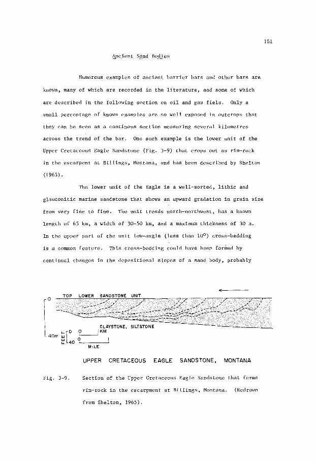
151
Apcient Sand Bodies ~ ~~ ~~~~~
Numerous examples of a n c i e n t b a r r i e r b a r s and o t h e r b a r s are
known, many of which a r e recorded i n t h e l i t e r a t u r e , and some of which
a r e desc r ibed i n t h e fol lowing s e c t i o n on o i l and gas f i e l s . Only a
s m a l l percentage of known examples a r e so w e l l exposed i n outcrops t h a t
they can be seen as a cont inous s e c t i o n measuring s e v e r a l k i lome t re s
ac ross t h e t r end of t h e b a r . One such example i s t h e lower u n i t of t h e
Upper Cretaceous Eagle Sandstone (Fig. 3-9) t h a t crops ou t as rim-rock
i n t h e e sca rpen t a t B i l l i n g s , Montana, and has been descr ibed by Shel ton
(1965).
The lower u n i t of t h e Eagle i s a wel l -sor ted, l i t h i c and
g l aucon i t i c marine sandstone t h a t shows an upward g rada t ion i n g r a i n s i z e
from very f i n e t o f i n e . The u n i t t r ends north-northwest, has a known
l eng th of 65 km, a width of 30-50 km, and a maximum th i ckness of 30 m.
In t h e upper p a r t of t h e u n i t low-angle ( l e s s than loo) cross-bedding
is a common f e a t u r e .
con t inua l changes i n t h e d e p o s i t i o n a l s l o p e s of a sand body, probably
This cross-bedding could have been formed by
TOP LOWER SANDSTONE UNIT
CLAY STONE, SILTSTO N E I KM
40m i[' I LL 40 O-
MILE
I; UPPER CRETACEOUS EAGLE SANDSTONE, MONTANA
Fig. 3-9. Sec t ion of t h e Upper Cretaceous Eagle Sandstone t h a t forms
(Redrawn rim-rock i n t h e escarpment a t B i l l i n g s , Montana.
from She l ton , 1965).

i n a p a r t of t h e body depos i t ed i n water too deep f o r i t t o be exposed
a t l o w t i d e , and which is consequent ly preserved i n t h e g e o l o g i c a l
r eco rd . I n t h e lower p a r t of t h e s e c t i o n b i o t u r b a t i o n is a common
f e a t u r e .
I n F ig . 3-9 t h e i n t e r s e c t i o n s of bedding p l anes wi th t h e
f a c e of t h e ou tc rop are shown as broken l i n e s . They have t h e same
r e l a t i o n s h i p t o t h e gemorphology of t h e b a r r i e r b a r as is shown i n
F ig . 3-4, and i n d i c a t e p rograda t ion i n a d i r e c t i o n toward t h e coas t -
l i n e , a s i n f e r r e d from pa leogeographic r e c o n s t r u c t i o n . Th i s geographic
r e l a t i o n s h i p sugges t s t h a t t h e b a r r i e r b a r w a s s i t u a t e d on a sha l low
c o n t i n e n t a l s h e l f , more than 80 km from t h e sho re toward which i t was
b u i l d i n g . I n such a geographic s i t u a t i o n t h e b a r , which e x t e r n a l l y
and i n t e r n a l l y has t h e f e a t u r e s of a barrier b a r , may i n f a c t no t have
formed a b a r r i e r .
O i l and Gas F i e l d s
O i l and gas f i e l d s i n b a r r i e r and o t h e r o f f s h o r e b a r s are
w e l l r ep resen ted i n t h e l i t e r a t u r e where they have o f t e n been recorded
s i n c e t h e e a r l y 1 9 2 0 ' s . I n f a c t , many of t h e ear l ier recorded sand
bod ies , r e f e r r e d t o as b a r s , have subsequent ly been found t o be d i s t r i -
bu ta ry channel sands . Lacking t h e c r i t e r i a t o adequte ly i n t e r p r e t t h e
o r i g i n of c e r t a i n hydrocarbon-bearing, l e n t i c u l a r and l i n e a r sands tone
bod ies , g e o l o g i s t s commonly r e f e r r e d t o then as b a r s . In some c a s e s t h e
term ba r w a s p robably used on ly t o d e s c r i b e t h e morphology o f t h e sand-
s t o n e body, w i th no i m p l i c a t i o n as t o i t s o r i g i n . In o t h e r c a s e s t h e
conno ta t ion of o r i g i n a s a b a r r i e r o r o t h e r o f f s h o r e b a r was i m p l i c i t .
Not u n t i l t h e 1 9 6 0 ' s were g e o l o g i s t s , i n g e n e r a l , d e s c r i b i n g such
sands tone bod ies i n more p r e c i s e geomorphologic t e r m s . Even s o , geolo-
g i s t s w e r e n o t always i n accord as t o t h e i n t e r p r e t a t i o n of t h e d a t a ,

153
and even in the early 1970's these differences were apparent.
example, with reference to the Recluse Field in Wyoming, where production
is obtained from the Recluse Sandstone at the base of the Lower Creta-
ceous Muddy Formation, Woncik (1972) interpreted the producing sandstone
as a marine shoreline sand that may have formed a barrier island, whereas
Forgotson and Stark (1972) interpreted the sandstone body as a channel-
fill sand.
For
Interpretations of the genesis and geomorphology of a sand-
stone body can be critical in cases where further exploration and
acquisition of petroleum leases depends upon, or is influenced by the
possible or probably trends of a prospective sandstone body.
Eighteen examples of oil and gas accumulations in barrier
bars and other offshore bars are given in the following pages. With the
exception of one example in Brazil, they are all in North America. They
range in age from Devonian to Tertiary, but do not include examples from
the Triassic or Jurassic. More than half are from the Cretaceous. A s
with the examples given of oil and gas accumulations in river distributary
and other channel-fill sand bodies, the number o f examples of accumulations
in bars is too small for their age and geographic distributions to be
significant. The distributions given relate in large measure to be
gecgaphic density of drilling.
accumulations in Eocene to Miocene bsrs trending parallel to the coast
in the Gulf Coast region of the U.S.A. and Mexico, and it does appear that
in North America the majority of examples are Cretaceous to Tertiary.
Many more cases could be cited of
Shira Streak Oil Field, Pennsylvania
The Shira Streak Oil Field (Fig. 3-10) of Pennnsylvania
produces from the Shira Sandstone in the upper part of the Third Sandstone
interval of the Upper Devonian Venango Group. The Shira, which is over-
lain and underlain by dark grey shales, is quartzose, meduim to coarse

154
2 O I
M I L E S
GEOMETRY OF SHlRA SANDSTONE,
P E N N S Y LVA N I A
Fig. 3-10. Isopach map of Shira Sandstone in the Upper Devonian Venango
Group, Shira Streak Oil Field, Pennsylvania. Contours in
feet (1 ' = 0.305 m). (Redrawn from Sherrill, Dickey, and
Matteson, 1941) .
grained, with local lenses of grit containing pebbles of quartz up to an
inch in diameter. Ranging up to 5m in thickness, the sandstone forms a
thin lenticular body more than 2Okm in length and up to 5km in width.
Sherrill, Dickey, and Matteson (1941) state that at the time
of deposition of the Shira Sandstone a continental environment was
situated to the southeast, and a marine environment to the northwest.
They suggest that the sandstone was possibly formed as an offshore bar.
If s o , it must have been in very shallow water, possibly in part exposed

155
as a beach subject to scouring and winnowing action by waves and currents
The coarseness of the sand, and the presence of pebbles, suggests that
if it had been an offshore bar, it would also have been near shore.
The Shira Streak Field, which yields oil having a gravity of
45' A.P.I., is essentially a stratigraphic trap. Other accumulations
within the Shira, yielding mainly gas, are located further up-dip where
a low, southeast-plunging fold crosses the trend of the sandstone body.
The Third Sandstone interval (Fig. 3-11) comprises two main
sandstone bodies, the upper one being the Shira. Several oil and gas
accumulations are known within the Third Sandstone. Initially, some
wells flowed oil at rates up to 3,000 barrels a day from the more
permeable zones within the pebbly, coarse sandstone zones, and early
production from many well approached 100 barrels a day.
gas at rates of 3-4 million cubic feet a day are also recorded. Most of
these accumulations have long since ceased to be of any economic signif-
icance. Sherrill, Dickey, and Matteson (1941, p. 509) state, "The
productive sands of this district lie at shallow depths - generally less than 1,000 feet. The pools discussed were discovered during the period
extending from 1859 to about 1900. They were found through random
drilling, prospecting near oil seeps, or through following trends. Many
of them have been partly or entirely abandoned one or more times and then
reclaimed through drilling between old locations, de-watering, air or gas
drive, or other methods".
Flows of wet
Austin Gas Field, Michigan
The Austin Field, Michigan (Fig. 3-12), produces gas from
the Michigan Stray Sand of the Mississippian Michigan Formation. The
Michigan Stray rests unconformably on the eroded surface of older
Mississippian rocks and occurs intermittently, as discrete sandstone
bodies, over a distance of 50-65 km. Ball, Weaver, and Crider (1941)

156
O d
0 KM 5 u
M I L E S
GEOMETRY OF THIRD SANDSTONE,
PE N N S Y L V A N I A
Fig . 3-11. Isopach map of Thi rd Sandstone i n t e r v a l , Upper Devonian
Venango Group, Pennsylvania. Contour i n t e r v a l i n f e e t
(1' = 0.305 m). (Redrawn from S h e r r i l l , Dickey, and
I l a t t e son , 1941).
i n t e r p e t t h e s e sands tone bodies a s o f f s h o r e b a r s , and show them t o be
b u i l t up on e r o s i o n a l r i d g e s t h a t more-or-less o v e r l i e and follow
a pre-Miss i ss ippian a n t i c l i n a l t r end . They show f u r t h e r a remarkable
co inc idence between t h e s t r u c t u r a l c o n f i g u r a t i o n and t h e t h i c k n e s s
of t h e sands tone body i n t h e Aus t in F i e l d , t h e body be ing t h i c k e s t
where i t i s h i g h e s t . In view of t h e f a c t t h a t no datum i s i n d i c a t e d on

157
L- M I L E A
GEOMETRY OF MICHIGAN STRAY SAND, AUSTIN
FIELD, MICHIGAN
Fig . 3-12. Isopach map of t h e Michigan S t r ay Sand i n t h e Miss i s s ipp ian
Michigan Formation, Aus t in Gas F i e l d , Michigan. Contour
i n t e r v a l i n f e e t (1 ' - 0.305 m). (Redrawn from Bal l , Weaver,
and C r i d e r , 1941).
t he s t r u c t u r e contour map, t h e i r i n t e r p r e t a t i o n of t h e o r i g i n a l shape
of t h e sand body i s s u s p e c t . These d i s c r e t e sand bodies were depos i t ed
on an unconformity, and o v e r l a i n by do lomi t i c and gyps i f e rous muds t h a t
probably i n d i c a t e l i t t o r a l and e v a p o r i t i c c o n d i t i o n s f l u c t u a t i n g from
very sha l low water t o c o a s t a l mud f l a t s .
t hese sand bod ies may have accumulated i n e r o s i o n a l dep res s ions , r a t h e r
than as sand b a r s buil-up from t h e s e a f l o o r . Such an a l t e r n a t i v e i n t e r -
p r e t a t i o n can be d e r i v e d , u s ing t h e same sub-sur face d a t a , a s d i scussed
i n an ear l ier s e c t i o n on compaction of sands tone bod ies (F igs . 1-12, 1-13),
Deposited by a t r a n s g r e s s i v e s e a ,
The sands tone body comprising t h e Aus t in F i e l d i s approxi-
mately 8 km i n l e n g t h and up t o 2 km i n wid th . The sands tone has a
maximum th i ckness of 10-12 m and is s a i d by B a l l , Weaver, and Cr ide r

158
(1941) to be more permeable where it is thicker.
one of several gas fields within the Michigan Stray Sand which originally
contained an estimated 150,000 million cubic feet (4,203 million cubic
metres) of gas.
The Austin Field is
Sallyards Trend Oil Fields, Kansas
In Butler and Greenwood Counties, Kansas, a number of oil fields
form a northeast-trending chain known as the Sallyards Trend (Fig. 3-13).
A shorter chain of oil fields, the Teeter Trend, lies nearly parallel to
the Sallyards along the border between Chase and Greenwood Counties.
Three other trends, from south to north respectively, known as the Haver-
Fig. 3-13. Geographical distribution of oil fields in shoestring sand-
stone trends within the lower part of the Pennsylvanian
Cherokee Formation, Kansas. Small squares are townships of
36 square miles (92 sq. km). (After Hilpman, 1958).

159
h i l l , Quincy, and Lamont Trends, c u t more-or-less a t r i g h t ang le , and a t
d i f f e r e n t ho r i zons , a c r o s s t h e S a l l y a r d s Trend. A l l of t h e o i l f i e l d s
a long t h e s e t r e n d s are i n s h o e s t r i n g sands tone bod ies w i t h i n t h e lower
p a r t o f t h e Lower t o Middle Pennsylvanian Cherokee Formation.
These sands tone bod ies form e l o n g a t e l e n s e s 15-30 m t h i c k , up t o
10 km long , and commonly more than 2 km wide. Arranged i n a l i n e a r
p a t t e r n l i k e a s t r i n g of beads , they form t r e n d s up t o 100 km long , and
a r e i n t e r p r e t e d by Bass (1936) and Hilpman (1958) as o f f s h o r e b a r s . The
sands tone bod ies a r e comple te ly surrounded by s h a l e c o n t a i n i n g a f a i r l y
h igh o r g a n i c con ten t . In t h e upper p a r t of t h e Cherokee Formation t h i s
o rgan ic - r i ch s h a l e c o n t a i n s c o a l beds and o i l -bea r ing s h o e s t r i n g sand-
s t o n e bod ies , i nc lud ing t h e Bush C i t y O i l F i e l d (Fig. 1-33), which are
i n t e r p r e t e d as d i $ t r i b u t a r y c h a n n e l - f i l l sands .
The sands tones i n t h e S a l l y a r d s and a s s o c i a t e d t r e n d s are
q u a r t z o s e , poor ly cemented, and f ine -g ra ined . They have f a i r t o good
pe rmeab i l i t y . Cumulative p roduc t ion t o 1970 amounted t o 250 m i l l i o n
b a r r e l s (39.8 m i l l i o n cub ic me t re s ) .
Wakita Trend, Oklahoma
The Wakita Trend of t h e Anadarko Bas in , Oklahoma h a s s e v e r a l
s e p a r a t e o i l and gas accumula t ions i n t h e Pennsylvanian Red Fork Sandstone
(F ig . 3-14).
forming an a r c u a t e t r e n d , i n t e r p r e t e d as a seuqence of p a r a l l e l o f f s h o r e
b a r s , i n t e r s e c t e d by two main s inuous t r e n d s i n t e r p r e t e d as younger
d i s t r i b u t a r y c h a n n e l - f i l l sands . The Wakita Trend, which has a l eng th
of more than 50 km, and a width of 2-3 km, w a s formed dur ing a l a t e
phase of t h e o f f s h o r e b a r depos i t i on . The t r e n d , c o n s i s t i n g o f t h r e e
b a r s t h a t are wider a t t h e base than a t t h e t o p , is te rmina ted f a i r l y
a b r u p t l y on bo th s i d e s by t h i n n i n g o f t h e sands tone bod ies and i n t e r -
The Red Fork comprises a complex o f s ands tone bod ies

160
ISOPACH OF WAKITA TREND,
RED FORK SANDSTONE,
O K L A H O M A .
Fig. 3-14. Isopach of the Wakita trend, Pennsylvanian Red Fork Sandstone,
Grant and Alfalfa Counties, Oklahoma, showing east-west
trending composite offshore bars. (Redrawn from Withrow, 1968).
fingering with shale. The sandstone bodies comprising the Wakita Trend
have a maximum composite thickness of 15 m and consist of fine to very
fine-grained quartzose sandstone that is generally micaceous and locally
argillaceous.
and permeability which average 15% and 2 millidarcys respectively.
Cementation by calcite and silica has reduced porosity

161
During the first decade of production, since discovery of the
Wakita Trend in 1953, not much more than 500,000 barrels of oil were
produced, mainly from the western half of the trend. Gas is also
produced, mainly from the eastern half of the trend. Producible reserves
have been estimated to be in excess of 65,000 million cubic feet (1,800
million cubic metres). Withrow (1968) points out that although the Wakita
Trend has yielded the poorest reservoirs, other Red Fork reservoirs in
the Anadarko Basin are much more profitable; and that additional
accumulations may be found on the basis of interpretations of the dep-
ositional environments and trends of the Red Fork Sandstone.
Olympic Oil Field, Oklahoma_
Production in the Olympic Oil Field, Oklahoma, is obtained from
the Pennsylvanian Olympic Sandstone (Fig. 3-15) which is developed as a
linear trend more than 10 km in length and up to 2 km in width. The
Olympic is a composite unit, up to 20 m thick, comprising two or more
overlapping sandstone bodies that are interpreted as marine ‘offshore
bars. The sandstone is quartzose, well-sorted and fine-grained. Thin
layers of sandy shale, and carbonaceous fragments are locally present.
Average porosity and permeability are 20% and 35 millidarcys respectively.
The Olympic dips to the northwest and is locally folded into
gentle noses.
some structural control. Production of greenish-black, 3 4 O A.P.I. oil
is obtained from a shallow depth of about 550 m. Recovery to date has
amounted to more than 12 million barrels (19 million cubic metres).
Entrapment of oil is essentially stratigraphic, but with
Mata-Catu Trend, Brazil
In the Salvador area of the Reconcavo Basin, Brazil (Fig. 3-16),
oil is produced from several reservoirs in the “A” Sandstone of the Lower
Cretaceous Itaparica Formation. This sandstone unit forms two narrow

162
1 J
GEOMETRY OF PRODUCING SANDSTONE,
OLYMPIC OIL FIELD, OKLAHOMA
Fig . 3-15. I sopach map of t h e Pennsylvanian Olympic Sandstone, Olympic
O i l F i e l d , Okfuskee County, Oklahoma. (Redrawn from D i l l a r d ,
1 9 4 1 ) .
p a r a l l e l t r ends and a b raode r , less wel l -def ined t r e n d s u b - p a r a l l e l t o
t h e o t h e r two. The longes t t r e n d , t h e Mata-Catu, has a l e n g t h of 40 km
and a wid th of 3-5 km. The sands tone bod ies comprising t h i s t r end have
a maximum composite t h i c k n e s s of 45 m.
The "A" u n i t is a wh i t e t o l i g h t g rey , predominantly qua r t zose ,
ve ry f i n e t o ve ry coarse-gra ined sands tone t h a t l o c a l l y c o n t a i n s g r i t - s i z e
g r a i n s and s m a l l pebbles . Other c o n s t i t u e n t s i nc lude g r a i n s of b l ack

163
\ \
0 20
KILOMETERS -
OIL FIELDS IN CRETACEOUS
'?I" SANDSTONE, BRAZIL
Fig. 3-16. D i s t r i b u t i o n of o i l f i e l d s i n l i n e a r t r ends of t h e Lower
Cre taceous "A" Sandstone, Sa lvador area, B r a z i l . Arrow
i n d i c a t e s i n f e r r e d d i r e c t i o n of sand t r a n s p o r t . (Redrawn
from Bauer, 1967).
c h e r t , f e l d s p a r , f l a k e s of mica, and heavy mine ra l s . The sands tone m a t r i x
c o n s i s t s of c l a y mine ra l s and carbonaceous ma t t e r . Grain g r a d a t i o n , where
i t has been no ted , is from f i n e r below t o c o a r s e r above, a common
r e l a t i o n s h i p i n prograding sand b a r s . This sands tone u n i t i s commonly
thick-bedded and mass ive , w i th s i l t y and carbonaceous l amina t ions . Minor
f e a t u r e s i n c l u d e low-angle cross-bedding, w i th scour and slump s t r u c t u r e s .
The sands tone bod ies comprising t h i s u n i t , which o v e r l i e s s h a l e s con ta in ing
f resh-water o s t r a c o d s , a r e cons idered by Bauer (1967) t o b e bar-shaped
l e n s e s of sand depos i t ed by c u r r e n t s and shaped by wave a c t i o n . He was

164
of t h e o p i n i o n t h a t t h e s e sand l e n s e s formed on s h e l v e s a n d s h o a l s i n sha l low
w a t e r , b u t a t some d i s t a n c e from s h o r e , i n a l a c u s t r i n e envi ronment .
The o i l r e s e r v o i r s have good p o r o s i t y , i n t h e ' range 12-20%, and
e x c e l l e n t p e r m e a b i l i t y , commonly 200-1,300 m i l l i d a r c y s b u t r a n g i n g up t o
4,000 m i l l i d a r c y s i n some medium-grained and w e l l s o r t e d s a n d s t o n e s . O i l ,
h a v i n g a g r a v i t y of 40°A.P.I., h a s accumula ted i n s t r u c t u r a l l y h i g h p a r t s
( a c c e n t u a t e d by compaction) of t h e s a n d s t o n e b o d i e s where t h e y o v e r l i e
u p - t h r u s t b l o c k s o f basement r o c k s . It is t h o u g h t by Bauer (1967) t h a t
basement s t r u c t u r e is r e f l e c t e d i n t h e p a l e o t o p o g r a p h y , and t h a t t h e sand
b a r s were developed on t h e h i g h e r areas. On t h e b a s i s of t h i s i n t e r p r e t -
a t i o n , h e s u g g e s t s t h a t t h e s e a r c h f o r new f i e l d s w i l l b e a s s i s t e d by a n
u n d e r s t a n d i n g o f t h e p a l e o s t r u c t u r a l and r e l a t e d paleogeomorphic f e a t u r e s
w i t h i n t h e Reconcavo Bas in .
B e l l Creek O i l F i e l d , Montana
The g e o g r a p h i c and paleogeomorphic r e l a t i o n s h i p of t h e B e l l Creek
and R e c l u s e o i l f i e l d s , Powder R i v e r B a s i n , Montana and Wyoming, are
shown i n F i g . 3-17, a f t e r t h e i n t e r p r e t a t i o n o f Forgotson and S t a r k (1972). ,
T h i s i n t e r p r e t a t i o n d i f f e r s from t h a t of Woncik (1972) who c o n s i d e r e d t h e
p r o d u c i n g s a n d s t o n e of t h e R e c l u s e O i l F i e l d (F ig . 1-46) t o b e a mar ine
s h o r e l i n e s a n d , p o s s i b l y a b a r r i e r i s l a n d . The producing zone i n b o t h
f i e l d s is t h e Lower C r e t a c e o u s Muddy Sands tone . The i n t e r p r e t a t i o n p l a c e d
on t h e i r paleogeomorphic r e l a t i o n s h i p , by Forgotson and S t a r k , i s t h a t t h e
o i l - b e a r i n g s a n d s t o n e body i n t h e B e l l ' C r e e k f i e l d (F ig . 3-18) i s a b a r r i e r
b a r complex. T h i s complex is l o c a t e d n e a r t h e i n t e r s e c t i o n of n o r t h e a s t -
- t r e n d i n g l i t t o r a l mar ine b a r s and a s o u t h e a s t - t r e n d i n g d e l t a sys tem.
The s a n d s t o n e body i n t h e R e c l u s e f i e l d i s i n t e r p r e t e d a s p a r t of a
d i s t r i b u t a r y c h a n n e l - f i l l sand w i t h i n t h e d e l t a sys tem.
The Muddy Sands tone i n t h e B e l l Creek O i l F i e l d i s a composi te

165
IN MILES ,
Fig. 3-17. Residual isopach values i n f e e t (1' = 305 m) of t h e Lower
Cretaceous Muddy Sandstone, Powder River Basin, Montana and
Wyoming.
polynomial va lues of r eg iona l s u r f a c e , shown by t h i n
con tour s , from isopach va lues . (After Forgotson and S ta rk ,
1972).
Residual va lues obtained by removal of 3d-degree
bar complex formed by merging, l i n e a r sandstone l e n s e s , t h e Muddy has a
cumulative maximum th i ckness of 10 m , and an average thickness of 6 m.
Four u n i t s have been descr ibed: (a) an upper, massive u n i t of f ine-grained
sandstone, (b) an underlying, s l i g h t l y coa r se r and s t rong ly laminated
sandstone, showing small-scale c ros s bedding, (c) a massive, very f ine -
-gpained, s l i g h t l y laminated sandstone with minor b io tu rba t ion , and (d)
a t h i n b a s a l u n i t of i n t e r l amina ted s h a l e and s i l t s t o n e with ex tens ive

166
MUDDY SANDSTONE, BELL CREEK FIELD, MONTANA.
Fig. 3-18. Isopach showing gross thickness in feet (1' = 0.305 m) of
Lower Cretaceous Muddy Sandstone, Bell Creek Field, Montana.
Lines of sections a-a' and b-b' are approximate. Sections
show lenticularity of oil-producing sandstone bodies.
(Redrawn from McGregor and Biggs, 1968, and Berg and Davis,
1968).
bioturbation. The sandstone is quartzose (ave. 86% quartz), well sorted,
and fine to very-fine-grained. The average grain size increases with
increasing quartz content. Porosity and permeability are exceptionally
good, ranging up to 30% and 3,500 millidarcys respectively.

167
5 0;03m.m
.I
A
4 670'
4 680'
BELL CREEK FIELD, MONTANA.
0
l m
C
0 '
lo'
2 0'
30'
,\
_1
B
GALVESTON ISLAND, TEXAS
Fig. 3-19. A - core from t h e o i l -producing Lower Cre taceous Wuddy
Sandstone i n Well No. 6-14, B e l l Creek F i e l d , Montana.
B - c o r e No. R 3963 from Recent sediments on Galves ton
I s l a n d , Texas, a t y p i c a l b a r r i e r i s l a n d . (Redrawn from
Davies , E t h r i d g e , and Berg, 1971).
Davies , E th r idge , and Berg (1971) made a comparison of t e x t u r e s
and s t r u c t u r e s i n co res (Fig. 3-19) from t h e Muddy Sandstone i n t h e B e l l
Creek O i l F i e l d and from Galveston I s l a n d , Texas, a t y p i c a l b a r r i e r i s l a n d .
The l e n g t h s of t h e Muddy and Galveston co res are approximate ly 6 m and 9 m

168
r e s p e c t i v e l y . The Galves ton I s l a n d co re shows an uppermost u n i t of e o l i a n
sand , w i th o c c a s i o n a l p l a n t r o o t s , ove r ly ing a u n i t of sand c o n t a i n i n g
i n t e r v a l s showing low-angle cross-bedding o f t h e type found w i t h i n beach
d e p o s i t s . Th i s t ype of cross-bedding r e f l e c t s v a r i a t i o n s i n d e p o s i t i o n a l
s l o p e s of t h e beach. The cross-bedded u n i t o v e r l i e s a homogeneous t o
f a i n t l y lamina ted u n i t o f sand depos i t ed as t h e seaward ex tens ion of an
i n t e r t i d a l beach. The lowermost u n i t i s of e x t e n s i v e l y b i o t u r b a t e d c layey
s i l t in t e rbedded wi th ve ry f ine -g ra ined sand . Gra in s i z e dec reases from
a f i n e sand i n t h e uppermost u n i t t o a very f i n e sand i n t h e lowermost
u n i t . This g r a d a t i o n i s t y p i c a l of b a r r i e r i s l a n d and o t h e r o f f - l app ing
s h o r e l i n e sand d e p o s i t s .
The B e l l Creek F i e l d co re shows t h e same sequence i n l i t h o l o g y ,
The uppermost u n i t i s o f ve ry f ine -g ra ined wi th minor v a r i a t i o n s .
homogeneous sand c o n t a i n i n g t r a c e s o f p l a n t r o o t s t r u c t u r e s . The i n t e r -
t i d a l beach u n i t con ta ins some organism burrows; and t h e o u t e r beach
s u r f a c e u n i t c o n t a i n s some rounded i n c l u s i o n of c l a y s t o n e , poss ib ly formed
from mudcrack fragments washed t o sea from a beach. The lowermost u n i t
c o n s i s t s e n t i r e l y of e x t e n s i v e l y b i o t u r b a t e d c l ays tone and s i l t s t o n e
laminae showing some very f i n e c ross - lamina t ions . Grain s i z e is w i t h i n
t h e f i n e sand r ange , 0 .25 - 0.12 nun, w i t h t h e excep t ion of t h e lowermost
u n i t which i s o f s i l t , 0.06 - 0.03 mm.
The B e l l Creek F i e l d was d i scove red i n 1967. It i s a s t r a t i g r a p h i c
t r a p i n which t h e f o u r s e p a r a t e accumula t ions of o i l have d i f f e r e n t o i l -
-water c o n t a c t s . The o i l , pumped from a depth o f about 1,400 m , i s su lphur-
- f r e e and has a g r a v i t y of 34O A.P.I.
t h e f i e l d y i e lded 65,000 b a r r e l s a day from w e l l s having an average d a i l y
p roduc t ion of 500 b a r r e l s . Cumulative p roduc t ion t o 1973 amounted t o 45
m i l l i o n b a r r e l s (7 .2 m i l l i o n cub ic me t re s ) . It is es t ima ted (McGregor
and Biggs, 1968) t h a t t h e r e s e r v e s o f p roduc ib le o i l amount t o 200 m i l l i o n
b a r r e l s (31.8 m i l l i o n cub ic me t re s ) .
During t h e pe r iod of peak product ion

169
Gas D r a w O i l F i e l d , Wyoming
The G a s D r a w O i l F i e l d (Fig. 3-20) i n t h e Powder River Bas in , Wyoming,
produces o i l from t h e 'Gas D r a w Sandstone i n t h e Lower Cre taceous Muddy
Formation. The Gas D r a w o v e r l i e s t h e o i l -producing sands tone i n t h e
B e l l Creek F i e l d (50 km n o r t h e a s t ) , and forms a composite l i n e a r sands tone
body more than 40 km long , 2-3 km wide, and up t o 10 m t h i c k . The main
o i l accumulation o f t h e f i e l d ex tends a long t h e c e n t r a l p a r t of t h i s
trer.d f o r a d i s t a n c e o f 20 km.
The Gas D r a w , c o n s i s t i n g of very f i n e t o f ine -g ra ined qua r t zose
sands tone , i s thought by Stone (1972) t o have o r i g i n a t e d a s a sequence of
o f f s h o r e b a r s and beaches a long t h e same s h o r e l i n e t r e n d as t h e B e l l
Creek Sandstone i n t h e upper p a r t of t h e Muddy Formation. I n t h i s
con tex t i t i s i n t e r e s t i n g t o n o t e t h e funnel-shaped c h a r a c t e r of t h e
E-log of b o t h t h e G a s D r a w and B e l l Creek sands tones (Fig. 3-21). A s i n
t h e B e l l Creek F i e l d , t h e producing sands tone of t h e Gas Draw F i e l d has
e x c e l l e n t r e s e r v o i r c h a r a c t e r i s t i c s i nc lud ing good p o r o s i t y and pe rmeab i l i t y .
The B e l l Creek, U t e , and K i t t y f i e l d s a l s o o b t a i n p a r t of t h e i r p roduct ion
from t h e Gas D r a w Sandstone.
Garr ington and C r o s s f i e l d O i l F i e l d s , A lbe r t a
The Garr ington and C r o s s f i e l d f i e l d s i n Albe r t a (Fig. 3-22) produce
o i l from t h e Upper Cre taceous Cardium Sands tsne . In t h i s area t h e Cardium
i s de f ined by two p a r a l l e l , ribbon-shaped sands tone t r e n d s about 15 km
a p a r t . The younger t r e n d , l y i n g f a r t h e r t o t h e n o r t h e a s t , i s t h e producing
sands tone of t h e Garr ington F i e l d .
d i r e c t i o n f o r more than 100 km. The C r o s s f i e l d t r e n d ex tends f o r more than
115 km. Both of t h e s e sands tone t r e n d s a r e 2-5 km wide and range i n
th i ckness up t o 6 m. They w e r e formed as o f f s h o r e b a r s , p o s s i b l y as
b a r r i e r b a r s , du r ing a pe r iod of marine r e g r e s s i o n i n t h e e a r l y L a t e
It has been t r a c e d i n a nor thwes t

+--
TYPE LOG
-.- '5 + GAS DRAW SANDSTONE
h d 1 7200' MUDDY
51
T
N 5 0
SANDSTONE ISOLIT GAS DRAW ZONE
C.I. 10'
-7 -60' TOTAL MUDDY
a MUDDY SANDSTONES UNDIFFERENTIATED UPPER
y @ ! I i ' l l l lr! . i __ .I__ A
? s p ) E T T E
Fig. 3-20. I s o l i t h of the Lower Cretaceous Gas Draw Sandstone showing a
l i n e a r p a t t e r n where the thickness ranges i n excess of 30
f e e t (9 m ) . Contour i n t e r v a l i s 10 f e e t (3 m). (After Stone,
1972).
'H

171
TYPE MUDDY LOG
I 1
S P R I N G E N R C H .
U P P E R R E C L U S E
O A K O T A S I L T
O A K O T A
7400'
Fig. 3-21. Type E-log from t h e G a s D r a w o i l f i e l d , Powder River Basin,
Wyoming. (Af t e r S tone , 1972).
Cretaceous. Subsequent ly , t hey were b u r i e d by da rk s i l t s and muds of
t h e Colorado Group when t h e s e a aga in t r ansg res sed westward.
The Cardium Sandstone i s l i t h i c , be ing composed o f g r a i n s of
c h e r t , q u a r t z , q u a r t z i t e , s i l i c i f i e d a r g i l l i t e , and o t h e r rock fragments.
In g e n e r a l , t h e sands tone is f ine -g ra ined , t h e g r a i n s be ing angu la r t o
sub-rounded.
g r i t t y t o pebbly , t h e l a r g e r g r a i n s and pebbles be ing w e l l rounded and
c o n s i s t i n g of l i g h t grey and b l ack c h e r t y rock . The cement i n t h e ma t r ix
i s l a r g e l y s i d e r i t e , i l l i t e and c h l o r i t e . Diagenes is and compaction have
r educed .po ros i ty and pe rmeab i l i t y which have mean va lues of approximate ly
10% and 35 m i l l i d a r c i e s r e s p e c t i v e l y .
In t h e upper p a r t of t h e s e c t i o n t h e sands tone i s l o c a l l y

172
ISOPACH MAP CARDIUM BARRIER
N w
CAL(
1 OJO KM
0- 10 MILES
Fig . 3-22. I sopach map of b a r r i e r b a r s of t h e Upper Cre taceous
Cardium Formation, Garr ington (A) and C r o s s f i e l d (B)
o i l f i e l d s , A lbe r t a . Isopach i n t e r v a l is 10 f e e t ( 3 m).
(Redrawn from Berven, 1966).
The o i l accumula t ions a r e i n pu re ly s t r a t i g r a p h i c t r a p s c o n t r o l l e d
by t h e up-dip l i m i t e s of pinch-out edges on t h e f l a n k s of t h e sands tone
b o d i e s , and by t h e d i s t r i b u t i o n of zones of v a r i a b l e p o r o s i t y and per-
m e a b i l i t y a long t h e t r e n d s . Regional d i p of t h e s t r a t a i s about 10 m/km
t o t h e west-southwest. The n e t producing sands tone i n bo th f i e l d s has a
range of on ly 1-2 m , and f r a c t u r i n g of t h e o i l -bea r ing zone is necessary .
The i n i t i a l r e s e r v o i r d r i v e was by s o l u t i o n g a s , bu t secondary recovery
methods invo lve t h e use of wa te r f lood ing .
In t h e Garr ington F i e l d t h e r e are two producing sands tone u n i t s ,
each having an average th i ckness of about 3m. The upper sands tone body

173
is ribbon-shaped and has s i m i l a r dimensions t o t h e sands tone body i n t h e
C r o s s f i e l d F i e l d . The lower body has t h e same t r e n d , bu t i s much more
i r r e g u l a r i n shape , ranging i n wid th up t o 10 km. Most w e l l s produce
from e i t h e r one sands tone o r t h e o t h e r , b u t some produce from both where
the u n i t s ove r l ap . The pa ra f f in -base o i l has a g r a v i t y of 370 A . P . I . and
i s su lphur - f r ee , O r i g i n a l o i l i n p l a c e i n both sands tone bod ies amounted
to 190 m i l l i o n b a r r e l s (20.2 m i l l i o n cub ic m e t r e s ) , of which i t i s
es t ima ted ( T y r e l l , 1966) t h a t 40 m i l l i o n (6 .4 m i l l i o n cubic metres) can
u l t i m a t e l y b e recovered . J a v e r i (1966) estimates t h a t t h e C r o s s f i e l d
had an o r i g i n a l o i l con ten t of 160 m i l l i o n b a r r e l s ( 2 5 . 4 m i l l i o n cubic
met res ) of which 16 m i l l i o n ( 2 . 5 m i l l i o n cub ic met res ) may be recovered ,
The d a i l y p roduc t ion rate pe r w e l l i s t h e range 20-40 b a r r e l s .
Fig. 3-23. Facies map of B i s t i o i l f i e l d , San Juan Bas in , New
Mexico, showing b a r r i e r b a r complex comprising t h e Marye,
Carson, and Huerfano o i l -bea r ing sand b a r s of t h e Upper
Cretaceous Gal lup Formation. (Af t e r Sab ins , 1963).
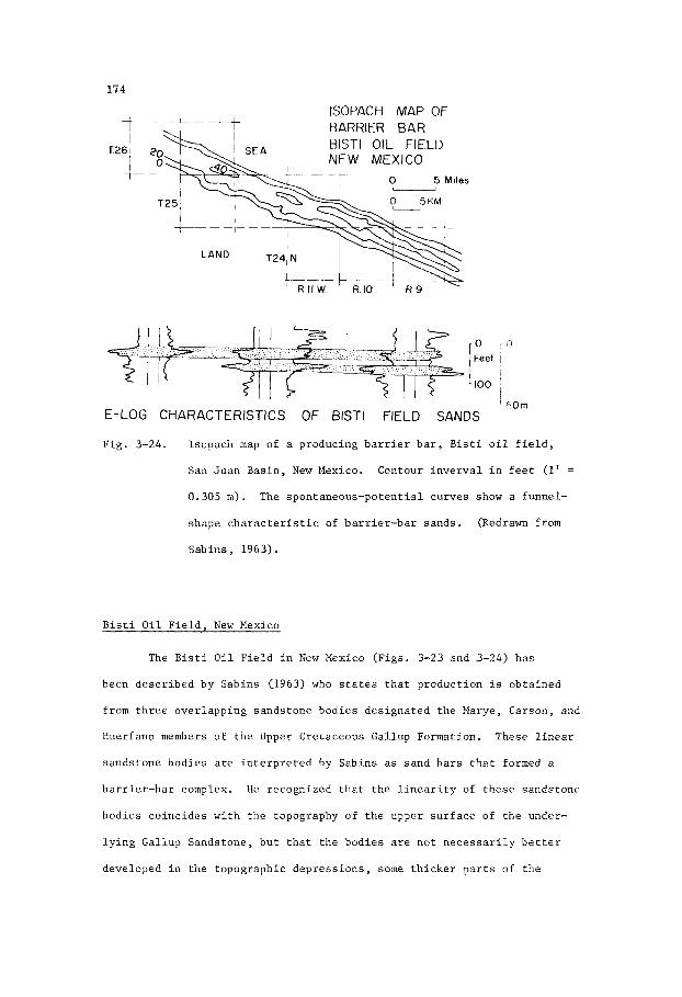
174
t 1
T26, I t-
ISOPACH MAP OF
L__I
o c , Feet 1
I ' &Om
E-LOG CHARACTERISTICS OF BlSTl FIELD SANDS
Pig . 3-24. Isopach map of a producing b a r r i e r b a r , B i s t i o i l f i e l d ,
San Juan Bas in , New Mexico. Contour i n v e r v a l i n f e e t (1' =
0.305 m).
shape c h a r a c t e r i s t i c of b a r r i e r - b a r sands .
Sab ins , 1963).
The spon taneous -po ten t i a l curves show a funnel -
(Redrawn from
B i s t i O i l F i e l d , New Mexico
The B i s t i O i l F i e l d i n New Mexico (F igs . 3-23 and 3-24 ) has
been desc r ibed by Sabins (1963) who s t a t e s t h a t p roduct ion is ob ta ined
from t h r e e ove r l app ing sands tone bod ies des igna ted t h e Marye, Carson, and
Huerfano members of t h e Upper Cre taceous Gal lup Formation. These l i n e a r
sands tone bod ies a r e i n t e r p r e t e d by Sabins as sand b a r s t h a t formed a
b a r r i e r - b a r complex. H e recognized t h a t t h e l i n e a r i t y of t h e s e sands tone
bod ies co inc ides w i t h t h e topography o f t h e upper s u r f a c e of t h e under-
l y i n g Gallup Sandstone, b u t t h a t t h e bod ies are n o t n e c e s s a r i l y b e t t e r
developed i n t h e topographic dep res s ions , some t h i c k e r p a r t s of t h e
175
bodies ove r ly ing escarpments . Sabins states, p. 224, "In summary, t h e
d e p o s i t i o n a l topography of t h e upper s u r f a c e of t h e Main Gal lup Sand
resembles longshore b a r and t rough topography wi th some seaward-facing
d e p o s i t i o n a l escarpments . Th i s topography w a s formed dur ing t h e f i n a l
d e p o s i t i o n of Main Gallup Sand and w a s t h e s u r f a c e upon which t h e B i s t i
ba r complex was depos i ted" . Sabins i n t e r p r e t s t h e Main Gal lup Sandstone
under ly ing t h e Marye, Carson, and t h e Huerfano sands tone bod ies as a re-
g r e s s i v e marine shee t -sand on t h e s u r f a c e of which sand b a r s and a s s o c i a t e d
f a c i e s (F ig . 3-23) were developed.
McCubbin (1969) on t h e o t h e r hand, i n t e r p r e t s t h e upper s u r f a c e of
t h e Main Gal lup Sandstone a s an e r o s i o n a l s u r f a c e on which l i n e a r sands tone
bod ies w e r e depos i t ed i n marine s t r j k e v a l l e y s f l a n k i n g c u e s t a s du r ing
t h e t r a n s g r e s s i o n of t h e Niobrara sea.
s p e c i f i c a l l y d e a l w i th t h e B i s t i F i e l d , b u t w i th t h e nearby Horseshoe,
Many Rocks, Mesa, South Waterflow, Cha Cha, and Totah f i e l d s which are
producing from t h e same s t r a t i g r a p h i c ho r i zon . McCubbin s ta tes , p. 2116,
"Most p rev ious s t u d i e s of t h e s e o i l f i e l d s l e d t o t h e i n t e r p r e t a t i o n t h a t
t h e r e s e r v o i r sands tone bod ies were depos i t ed as "o f f shore ba r s " o r
"marine ba r s " contemporaneously wi th t h e beach and nearshore-marine
sands tones of t h e Gal lup , and t h a t t h e i r l o c a t i o n and t r e n d are r e l a t e d
t o t h e maximum e x t e n t of t h e Gal lup r e g r e s s i o n @bight and Budd, 1959;
Sab ins , 1963; Tomkins, 1957). P e n t t i l a (1964) recognized t h a t t h e
sands tone beds i n t h e nor thwes tern p a r t of t h e b a s i n o v e r l i e an uncon-
fo rmi ty which s e p a r a t e s them from t h e o l d e r Gallup Sandstone, and t h a t
t h e d i s t r i b u t i o n of t h e sands tone bod ies i s r e l a t e d t o e r o s i o n a l l o w s
on t h e unconformity".
t o t h e B i s t i F i e l d , t hen t h e Marye, Carson, and Huerfano sands tone bodies
a r e b a s a l members of t h e Upper Cre taceous Niobrara Formation, and as
s t r i k e - v a l l e y sands f l a n k i n g c u e s t a s should be a s s igned t o Chapter 5 on
McCubbin's s t u d y d i d n o t
I f McCubbin's i n t e r p r e t a t i o n can b e a p p l i e d a l s o

176
t r a n s g r e s s i v e marine s h o r e l i n e sand bod ies . They are p laced i n t h i s
c h a p t e r , because:
( a ) t h e q u e s t i o n of t h e i r o r i g i n does n o t y e t seem t o
have been s a t i s f a c t o r i l y r e s o l v e d ,
t hey were a p p a r e n t l y formed i n a nea r shore marine
environment, and
(b)
(c) t h e i r funnel-shaped E-log c h a r a c t e r (F ig . 3-24)
s u g g e s t s that they w e r e sand b a r s
The producing sands tones of t h e B i s t i f i e l d form a l i n e a r t r e n d
more than 55 km long , 3-5 km wide and up t o 20 m t h i c k . The sands tones
are qua r t zose , g l a u c o n i t i c , and c o n s i s t of f i n e t o medium, sub-rounded
g r a i n s . Gra in g r a d a t i o n is from f i n e r below t o c o a r s e r above, a
r e l a t i o n s h i p t h a t i s c h a r a c t e r i s t i c of b a r r i e r b a r s . The funnel-shaped
E-logs (Fig. 3-24) r e f l e c t t h i s g r a d a t i o n . P o r o s i t y is i n t h e range
10-20% b u t i s commonly 12-55%. Pe rmeab i l i t y i n t h e c o a r s e r sands tones
ranges up t o 400 m i l l i d a r c y s , b u t t h e average sands tones a r e w i t h i n t h e
range 50-175 m i l l i d a r c y s .
The B i s t i F i e l d i s a s t r a t i g r a p h i c t r a p , t h e r e be ing no s t r u c t u r a l
i n f l u e n c e by noses o r c l o s u r e s e i t h e r above o r below t h e producing sand-
s t o n e u n i t s i n t h e f i e l d . Well completions normally r e q u i r e f r a c t u r i n g
of t h e sands tone t o y i e l d an average product ion of more than 900 b a r r e l s
pe r w e l l pe r month.
s o l u t i o n d r i v e . I t is es t ima ted t h a t u l t i m a t e recovery from t h e f i e l d
w i l l amount t o 50 m i l l i o n b a r r e l s (8 m i l l i o n cubic me t re s ) .
The primary producing mechanism i s by means of gas
S a l t Creek - Teapot Dome O i l F i e l d , Wyoming
The S a l t Creek F i e l d (Fig. 3-25) and t h e ad jacen t Teapot Dome t o
t h e sou th are p r o l i f i c o i l f i e l d s producing mainly from t h e Second Sand-
s t o n e member of t h e Upper Cre taceous F r o n t i e r Formation. The Second

177
? ;o
O U KM 10
M I L E S
C A S P E R @
OIL FIELDS IN OFFSHORE BAR, FRONTIER
FORMATION, WYOMING
Fig. 3-25. Salt Creek oil field within a structural nose along the
trend of the Second Sandstone, an offshore bar in the Upper
Cretaceous Frontier Formation. (Redrawn from Barlow and
Haun, 1966) .
Sandstone lies about 60 m stratigraphically below the First Sandstone, at
depths of 400-900 m.
The Second Sandstone is interpreted by Barlow and H a m (1966) as
a marine offshore bar fringing a deltaic lobe that prograded eastward.
The sandstone body trends north-northwest for more than 100 km. It

178
ave rages about 15 km i n wid th , and i s up t o 30 m t h i c k .
c o i n c i d e s w i t h t h e a x i s of an undu la t ing a n t i c l i n e a long which s e p a r a t e
c l o s u r e s , such as t h e Teapot Dome, have developed. The sands tone i s
q u a r t z o s e , w e l l s o r t e d , ve ry f i n e t o medium-grained and l o c a l l y c ros s -
-bedded. It has an average p o r o s i t y of 20%. Glaucon i t e is a common
c o n s t i t u e n t , and i n p l a c e s t h e sands tone c o n t a i n s carbonaceous f ragments .
The g r a i n s , which are sub-rounded t o sub-angular , show a g r a d a t i o n i n
s i z e from f i n e r below t o c o a r s e r above. Th i s g r a d a t i o n i s r e f l e c t e d i n
t h e funnel-shaped E-log c h a r a c t e r of t h e Second Sandstone. L o c a l l y , t h e
sands tone body c o n t a i n s l e n s e s of pebb les , and w i t h i n t h e uppermost p a r t
t h e r e i s a widespread pebble bed. A s imilar pebble bed , which r e p r e s e n t s
a p e r i o d of s c o u r i n g of t h e o f f s h o r e b a r s , is p r e s e n t a t t h e t o p of t h e
o i l -p roduc ing Cardium Sandstone (F ig . 3-22) of A lbe r t a .
The t r e n d
Bech (1929) shows d i f f e r e n t o i l -wa te r c o n t a c t s w i t h i n t h e S a l t
Creek - Teapot Dome s t r u c t u r e .
r a t h e r t han t i l t i n g of t h e o i l -wa te r s u r f a c e . The s a l i n i t y range of t h e
w a t e z i n t h e Second Sandstone is 8,000-15,000 p.p.m., w e l l below the
average sea water range o f 30,000 p.p.m., which s u g g e s t s t h a t t h e r e h a s
been some d i l u t i o n of t h e connate water w i t h me teo r i c w a t e r , and t h a t
consequent ly t h e r e may be some movement of wa te r w i t h i n t h e sands tone
body. Lack of e a r l y p r e s s u r e d a t a , however, p rec ludes t h e p o s s i b i l i t y
o f making a s a t i s f a c t o r y hydrodynamic a n a l y s i s .
These a r e p o s s i b l y t h e r e s u l t of f a u l t i n g ,
Barlow and Haun (1966, p. 2195) summarize t h e f i e l d as fo l lows ,
" S a l t Creek f i e l d commonly h a s been s e l e c t e d as an o u t s t a n d i n g example of
an a n t i c l i n a l accumula t ion . It h a s been c i t e d a s an example of d i f f e r -
e n t i a l en t rapment by Gussow (1954) and as an example of f i e l d s w i t h
t i l t e d o i l -wa te r c o n t a c t s by Levorsen (1954, p. 295)*. The writers have
a t t empted t o show t h a t t h e major accumula t ion , i n t h e second F r o n t i e r
Footnote : p. 151 of t h e 2nd E d i t i o n (1967)

179
sands tone , i s w i t h i n a sand b a r t h a t w a s depos i t ed a t t h e seaward margin
of a l o b a t e concen t r a t ion of c o a r s e , t e r r i g e n o u s c l a s t i c s (a d e l t a ? ) ,
which were de r ived from a l and a r e a on t h e w e s t and nor thwes t . The b a r
w a s sub jec t ed t o s t r o n g wave and c u r r e n t a c t i o n which produced r e l a t i v e l y
high p o r o s i t y through s o r t i n g p rocesses . The b a r became a s t r a t i g r a p h i c
t r a p du r ing t h e e a r l y s t a g e s of sediment compaction and accumulated
petroleum de r ived from t h e sur rounding source beds i n t h e F r o n t i e r . During
Laramide f o l d i n g , t h e o i l migra ted t o approximate ly i t s p r e s e n t s t r u c t u r a l
p o s i t i o n . Subsequent hydrodynamic g r a d i e n t s may have modified s l i g h t l y
t h e s t r u c t u r a l p o s i t i o n of t h e o i l " .
The S a l t Creek - Teapot Dome F i e l d has y i e lded up ' to 1966, a t o t a l
of 420 m i l l i o n b a r r e l s (66.8 m i l l i o n cub ic met res ) of o i l having a g r a v i t y
range of 33O-380 A . P . I . I n i t i a l l y , p roduc t ion was p a r t l y a s s i s t e d by
gas-so lu t ion d r i v e , and the average d a i l y product ion from e a r l y w e l l s
d r i l l e d du r ing t h e pe r iod 1917-1921 was 670 b a r r e l s p e r w e l l .
Big Piney Gas F i e l d , Wyoming
The Big Piney F i e l d of t h e Green River Bas in , Wyoming, produces gas
from l e n t i c u l a r sands tone u n i t s i n t h e Paleocene Almy Formation. One of
these u n i t s , t h e "La" Sandstone member (Fig. 3-26) is a major producer .
This sands tone u n i t comprises two s e p a r a t e sands tone bod ies wi th a s l i g h t
en echelon alignment i n p l an view. Both bod ies t r e n d s n o r t h , a r e l i n e a r ,
l e n t i c u l a r , and ranges i n t h i c k n e s s up t o 40 m. They p inch ou t f a i r l y
a b r u p t l y t o t h e w e s t and become s i l t y t o t h e east . These sands tone bodies
are i n t e r p r e t e d as o f f s h o r e b a r s .
i n t e r p r e t e d a s e s t u a r i n e o r d e l t a i c i n o r i g i n .
Other a s s o c i a t e d sands tone bod ies are
The Big Piney f i e l d w a s d i scovered i n 1938. One of t h e e a r l y w e l l s
blew i n wh i l e be ing cored a t a depth of about 300 m. Gas flowed a t t h e

180
0 KM 6
M I L E S I
GEOMETRY OF "La" GAS SAND, B I G
PI N E Y FIELD, WYOMING
Fig . 3-26. Isopach map of t h e "La" Sandstone i n t h e Paleocene Almy
Formation, Big Piney Gas F i e l d , Green River Basin, Wyoming.
Contour i n t e r v a l i n f e e t (1' = 0.305 m). (Redrawn from
Krueger, 1968).
r a t e of 70 m i l l i o n cubic f e e t a day f o r 10 days be fo re being brought under
c o n t r o l .
t h i c k . Within t h e f i e l d , 20 s e p a r a t e and l e n t i c u l a r sandstone bodies
within t h e Almy Formation, of which t h e "La" member is one, con ta in gas
and minor q u a n t i t i e s of o i l .
s t r a t i g r a p h i c , t h e gas and o i l being confined by po ros i ty and permeabi l i ty
The producing sandstone a t t h i s l o c a t i o n is approximately 30 m
These hydrocarbon accumulations a r e e s s e n t i a l l y
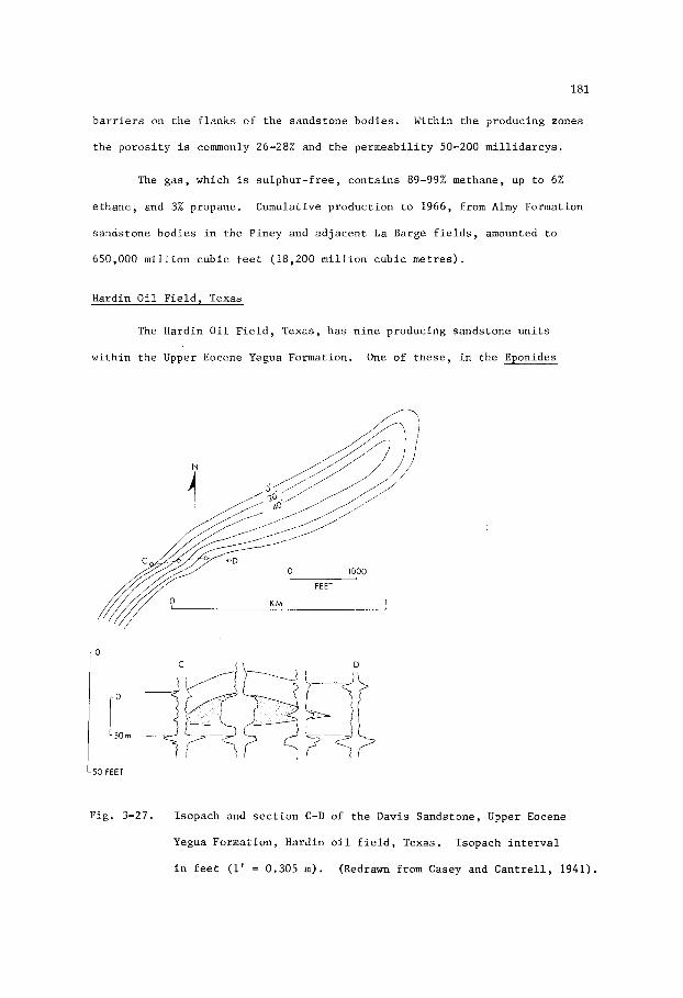
181
b a r r i e r s on t h e f l a n k s of t h e sands tone bod ies . Within t h e producing zones
t h e p o r o s i t y is commonly 26-28% and t h e p e r m e a b i l i t y 50-200 m i l l i d a r c y s .
The gas , which i s s u l p h u r - f r e e , c o n t a i n s 89-99% methane, up t o 6%
e thane , and 3% propane. Cumulative p roduc t ion t o 1966, from Almy Formation
sands tone bod ies i n t h e P iney and a d j a c e n t L a Barge f i e l d s , amounted t o
650,000 m i l l i o n c u b i c f e e t (18,200 m i l l i o n cub ic me t re s ) .
Hardin O i l F i e l d , Texas
The Hardin O i l F i e l d , Texas, h a s n i n e producing sands tone u n i t s
w i t h i n t h e Upper Eocene Yegua Formation. One of t h e s e , i n t h e Eponides
FEET
I d
KM
L50 FEET
Fig . 3-27. I sopach and s e c t i o n C-D of t h e Davis Sands tone , Upper Eocene
Yegua Format ion , Hardin o i l f i e l d , Texas. I sopach i n t e r v a l
i n f e e t (1' = 0.305 m). (Redrawn from Casey and C a n t r e l l , 1941).
182
yeguaens i s zone o f t h e Tegua, is t h e Davis Sandstone (F ig . 3-27) which
y i e l d s g a s , d i s t i l l a t e , and o i l . The Davis is a l i n e a r and l e n t i c u l a r body
having a l e n g t h of 3 . 3 km, a wid th i n t h e range 150-350 m , and a maximum
t h i c k n e s s of 15 m. In g e n e r a l , i t forms a massive sands tone body and
shows no s t r a t i f i c a t i o n excep t i n t h e s h a l y zones , a long t h e f l a n k s of
t h e body, where i t e x h i b i t s some cross-bedding. The sands tone i s medium-
-grained and c o n s i s t s of approximate ly 98% qua r t z . The g r a i n s are
sub-angular t o angu la r . Carbonized p l a n t f ragments are common. The
sands tone body i s i n t e r p r e t e d as a marine o f f s h o r e b a r depos i t ed i n a
r e g r e s s i n g sea. The E-log c h a r a c t e r s of the Yegua sands tone u n i t s are
d i s t i n c t l y funnel-shaped, which sugges t s t h a t t h e u n i t s o r i g i n a t e d as
sand b a r s . The E-log c h a r a c t e r of t h e Davis Sandstone i s l e s s w e l l
d e f i n e d , p o s s i b l y because i t is f a i r l y uniform i n g r a i n s i z e .
The sands tone h a s e x c e l l e n t p e t r o p h y s i c a l p r o p e r t i e s , t h e average
p o r o s i t y and pe rmeab i l i t y be ing 27% and 2,200 m i l l i d a r c y s r e s p e c t i v e l y .
The presence o f b r a c k i s h water, having a s a l i n i t y of 12,000 p a r t s p e r
m i l l i o n , sugges t s some degree of d i l u t i o n of t h e connate water by
me teo r i c water. Consequently, t h e r e is a p o s s i b i l i t y t h a t a hydrodynamic
c o n d i t i o n e x i s t s i n , t h e f i e l d . The Davis Sandstone, encountered a t a
dep th of about 2,285 m below t h e s u r f a c e , y i e l d s gas , 550 A.P . I . d i s t i l l a t e ,
and 3 7 O A.P.I. o i l .

183
Chapter 4
REGRESSIVE MARINE SHORELINE SAND
I n t r o d u c t i o n
Geomorphology
Regress ive marine s h o r e l i n e sand bod ies c o n s i s t of s t r a t i f o r m and
l e n t i c u l a r bod ie s of sand depos i t ed as beaches o r of f - shore sands dur ing
a pe r iod of r e g r e s s i o n of t h e sea.
a long t h e c o a s t . They commonly e x h i b i t a p a r a l l e l arrangement i n p l an
view and an en echeZon arrangement i n s e c t i o n a l view.
no t always e v i d e n t w i thou t v e r t i c a l exagge ra t ion of t h e s e c t i o n , p a r t i c u l a r l y
where i n t e r n a l s t r a t i g r a p h i c markers cannot c l e a r l y be de f ined . A sand-
s tone u n i t t h a t appears t o have a s h e e t - l i k e d i s t r i b u t i o n , and which has
been r e f e r r e d t o as a ' b l a n k e t s a n d ' , may i n f a c t comprise a sequence of
s e p a r a t e , o f f - l app ing sands tone bod ies t h a t c o n s t i t u t e a diachronous u n i t .
Other s ands tone bod ies , such as beach r i d g e s , may b e c l e a r l y sepa ra t ed by
s h a l e o r s i l t s t o n e . Inc luded i n t h e ca t egory of s h o r e l i n e sand bod ies
depos i t ed by a r e g r e s s i n g s e a are some d e l t a - f r o n t sand bodies such a s
bar - f inger s ands , and a l so some i n t e r - d e l t a i c sand bod ies such a s b a r r i e r
i s l a n d sands and o t h e r o f f s h o r e b a r s . i k l t a - f r o n t sand bod ies a r e n o t
d e a l t w i th i n t h i s chap te r because they are e s s e n t i a l l y t h e prograding
seaward ex tens ions of d e l t a d i s t r i b u t a r y sand bod ies (F igs . 2-2 and 2-4)
t h a t t r e n d , i n g e n e r a l , normal t o t h e c o a s t l i n e . Some b a r r i e r and o t h e r
o f f s h o r e b a r s could p rope r ly be inc luded i n t h i s chap te r , b u t because they
can a l s o form i n marine t r a n s g r e s s i v e s i t u a t i o n s (F ig . 3-9) they a r e
inc luded i n a separate chap te r .
These sand bod ies a r e l i n e a r and t r end
The l a t t e r view i s
Regress ive and t r a n s g r e s s i v e s i t u a t i o n s can a r i s e where t h e

184
landmass ad jacen t t o t h e sea i s f l a t and low.
n a t u r e of t h e t e r r a i n , low-re l ie f topography may be developed t o a l a r g e
e x t e n t by e r o s i o n a l p rocesses . Very f l a t c o a s t a l areas a d j o i n i n g t h e
low- re l i e f topography a r e formed e s s e n t i a l l y by prograding d e p o s i t i o n a l
p rocesses . Vast a r e a s o f c o a s t a l f l a t - l a n d s can , subsequent t o t h e i r
format ion by sed iments a c c r e t i n g t o t h e c o a s t du r ing a pe r iod of marine
r e g r e s s i o n , b e subsequent ly inundated and p a r t l y re-worked du r ing a
pe r iod of marine t r a n s g r e s s i o n .
Depending on t h e geo log ica l
P rograda t ion , and t h e consequent seaward ex tens ion of f l a t c o a s t a l
p l a i n s , can be r a p i d in s i t u a t i o n s where t h e d e l t a s of l a r g e r i v e r systems
are growing o u t on a sha l low c o n t i n e n t a l p la t form. I n t h i s s i t u a t i o n ,
beach r i d g e s , b a r r i e r b a r s , and o t h e r o f f s h o r e sand bod ies can b e seen a s
topographic f e a t u r e s , commonly a s vege ta t ion-covered , low-lying sandy
r i d g e s , f o r many k i lome te r s i n l a n d . Subsequent drowning of t h e c o a s t a l
topography, du r ing a pe r iod of marine t r a n s g r e s s i o n , may bury t h e s e
f e a t u r e s i n mud and p rese rve them i n t h e g e o l o g i c a l r eco rd . 4 l though
world-wide rises of sea l e v e l are known t o co inc ide wi th pe r iods du r ing
which t h e i c e caps w e r e me l t ing , and may also r e f l e c t major t e c t o n i c
movements, t r a n s g r e s s i o n s do n o t n e c e s s a r i l y imply an a b s o l u t e r ise of
sea l e v e l . Loca l marine t r a n s g r e s s i o n s commonly occur i n a r e a s of l a r g e
d e l t a s where p rograda t ion i s no longe r t a k i n g p l a c e because t h e r i v e r
sys tem has changed i t s course and is n o t supply ing sediment t o t h a t p a r t
of t h e c o a s t . In t h i s s i t u a t i o n t h e c o a s t l i n e ceases t o mig ra t e seaward
by t h e a c c r e t i o n of sed iment , bu t t h e d e l t a sediments benea th t h e c o a s t a l
p l a i n con t inue t o compact. A s much of t h e swampy s u r f a c e of t h e d e l t a is
less than one meter above sea l e v e l , t h e s u r f a c e s i n k s benea th t h e sea .
Drowning of t h e s e f l a t c o a s t a l p l a i n s can t a k e p l a c e over a pe r iod of a
few y e a r s , a l though t h e advance of t h e sea may n o t b e a t a cons t an t rate.
During p e r i o d s of slow advance, cond i t ions approximating a s t i l h s t a n d may
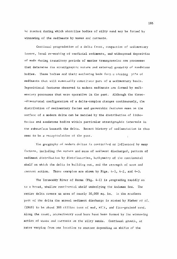
185
be reached du r ing which s h o r e l i n e bod ies of s i l t y sand may be formed by
winnowing o f t h e sed iments by waves and c u r r e n t s .
Cont inua l p rograda t ion of a d e l t a f r o n t , compaction of sedimentary
l a y e r s , l o c a l re-working o f s u r f i c i a l sed iments , and widespread d e p o s i t i o n
of muds du r ing t r a n s i t o r y pe r iods of marine t r a n s g r e s s i o n are p rocesses
t h a t de te rmine t h e s t r a t i g r a p h i c n a t u r e and e x t e r n a l geometry of sands tone
bodies . p i l e of
sediments t h a t w i l l e v e n t u a l l y c o n s t i t u t e p a r t of a sed imentary b a s i n .
Depos i t i ona l f e a t u r e s observed i n modern sed iments are formed by sed i -
mentary p rocesses t h a t were o p e r a t i v e i n t h e p a s t . Although t h e th ree -
-dimensional c o n f i g u r a t i o n of a delta-complex changes con t inuous ly , t h e
d i s t r i b u t i o n o f sed imentary f a c i e s and geomorphic f e a t u r e s seen on t h e
s u r f a c e of a modern d e l t a can be matched by t h e d i s t r i b u t i o n of l i t h o -
f a c i e s and sands tone bod ies w i t h i n p a r t i c u l a r s t r a t i g r a p h i c i n t e r v a l s i n
the subsu r face benea th t h e d e l t a . Recent h i s t o r y of sed imenta t ion i s thus
seen t o be a r e c a p i t u l a t i o n of t h e p a s t .
These bod ies and t h e i r e n c l o s i n g beds form a s i n k i n g
The geography of modern d e l t a s is c o n t r o l l e d o r i n f luenced by many
f a c t o r s , i nc lud ing t h e n a t u r e and mass of sediment d i scha rged , p a t t e r n of
sediment d i s t r i b u t i o n by d i s t r i b u t a r i e s , bathymetry of t h e c o n t i n e n t a l
s h e l f on which t h e d e l t a i s b u i l d i n g o u t , and t h e s t r e n g t h of wave and
c u r r e n t a c t i o n . Three examples are shown by F igs . 4-1, 4-2 , and 4 - 3 .
The Irrawaddy River of Burma (Fig. 4-1) is prograding r a p i d l y on
t o a broad , sha l low c o n t i n e n t a l s h e l f under ly ing t h e Andaman Sea. The
e n t i r e d e l t a covers an area of n e a r l y 50,000 sq . km. In t h e sou the rn
p a r t of t h e d e l t a t h e annual sediment d i scha rge i s s t a t e d by F i she r e t al.
(1969) t o be about 300 m i l l i o n tons of mud, s i l t , and f ine-gra ined sand.
Along t h e c o a s t , a c c r e t i o n a r y sand b a r s have been formed by t h e winnowing
a c t i o n o f waves and c u r r e n t s on t h e s i l t y sands .
r a t e s va ry ing from one l o c a t i o n t o ano the r depending on s h i f t s of t h e
Cont inua l growth, a t

186
D I S T R I B U T A R I E S A N D SAND BARS,
I R R A W A D D Y DELTA
Fig . 4-1. P a t t e r n of main d i s t r i b u t a r i e s , t i d a l channe l s , and
a c c r e t i o n a r y sand b a r s i n t h e sou the rn p a r t of t h e Holocene
d e l t a of t h e Irrawaddy R ive r , Burma. (Redrawn from F i s h e r
e t aZ. 1969).
d i s t r i b u t a r i e s and changes i n t h e i r volume of d i scha rge , h a s r e s u l t e d i n
t h e abandonment of o l d e r a c c r e t i o n a r y b a r s .
i n l m d where they form l i n e a r t r e n d s o u t l i n i n g t h e p re -ex i s t ing s h o r e l i n e s .
Later pe r iods of r e g i o n a l o r l o c a l marine t r a n s g r e s s i o n s may bury t h e s e
i n l a n d sand bod ies wi th mud, t hus p re se rv ing them i n t h e g e o l o g i c a l record .
Subsequent growth of t h e sed imentary p i l e r e s u l t s i n t h e b u r i a l of sand
bod ies t o dep ths of hundreds o r thousands of metres where hydrocarbon
g e n e r a t i o n , f l u i d movements, and penecontemporaneous deformation by
compaction, slumping, and growth s t r u c t u r e s combine t o concen t r a t e o i l
and gas w i t h i n some of t h e sand o r sands tone u n i t s .
These g r a d u a l l y r e t r e a t f a r t h e r
Regions where t h e d e p o s i t i o n a l environments are of t h i s n a t u r e ,

187
and where they have been similar i n t h e g e o l o g i c a l p a s t , are a t t r a c t i v e
a reas i n which t o exp lo re f o r o i l and gas. Such r eg ions a r e l i k e l y t o
have a r e l a t i v e l y h igh o r g a n i c con ten t n o t on ly i n t h e present-day muds
but a l s o i n t h e subsu r face mudstones o r s h a l e s . Depos i t i ona l environments
t h a t have n o t been t e c t o n i c a l l y d i s t u b e d o r s u b j e c t e d t o ex tens ive
pe r iods of e r o s i o n a r e less l i k e l y t o have l o s t an apprec i ab le volume of
hydrocarbons. Furthermore, t h e broad and sha l low c o n t i n e n t a l she lves on
which such d e l t a i c systems grow are amenable t o d r i l l i n g .
In c o n t r a s t t o t h e d e l t a of t h e Irrawaddy River , t h e Nile d e l t a
(F ig . 4-2 ) i n t h e United Arab Republ ic has marked d i f f e r e n c e s i n geometry,
and probably a l s o i n i n t e r n a l s t r u c t u r e . These d i f f e r e n c e s are t h e r e s u l t
F ig . 4-2 . P a t t e r n of t h e main d i s t r i b u t a r i e s and c o a s t a l sands t h a t
form b a r r i e r - s t r a n d p l a i n s i n t h e Holocene d e l t a of t h e N i l e
R ive r , United Arab Republ ic . (Redrawn from F i s h e r e t al.,
1969).

188
of s e v e r a l f a c t o r s r e l a t e d t o rates of sediment d i scha rge , c l i m a t e , and
t h e bathymetry of t h e Medi te r ranean Sea east of Alexandr ia .
d i s t r i b u t a r i e s of t h e N i l e R ive r , shows i n F ig . 4-2 are t h e wes te rn Rose t t a
branch and t h e e a s t e r n D a n i e t t a branch. The t o t a l annual d i scha rge of
sediment from t h e s e d i s t r i b u t a r i e s is s t a t e d by F i she r e t aZ. (1969) t o
be approximate ly 60 m i l l i o n t o n s , o r one f i f t h of t h e d i scha rge from t h e
Irrawaddy River . However, much of t h e f ine -g ra ined sediment c a r r i e d by
t h e N i l e R iver du r ing pe r iods of f l o o d never r eaches t h e s e a , bu t i s
depos i t ed on t h e f l o o d p l a i n when t h e r i v e r l e v e l f a l l s .
of d i scha rge i n t o t h e sea is r e f l e c t e d n o t on ly i n s i z e , t h e Nile d e l t a
cover ing 15,000 s q . km. which i s less than one t h i r d t h e area of t h e
Irrawaddy d e l t a , b u t a l s o i n t h e g r e a t e r development of o f f s h o r e b a r s . In
p a r t i c u l a r , b a r r i e r b a r s have formed a c r o s s l a r g e lagoons , a lmost completely
c u t t i n g them o f f and consequent ly r a i s i n g t h e s a l i n i t y s o t h a t t hey a r e
surrounded by c o a s t a l s a l t marsh and e v a p o r i t e mud f l a t s . Fa r the r i n l a n d
t h e d e l t a forms an e x t e n s i v e f lood p l a i n .
The two main
The lower r a t e
E x t e r n a l l y , t h e N i l e d e l t a c o n t r a s t s markedly n o t on ly wi th t h e
Irrawaddy d e l t a , b u t a l s o wi th t h e c l a s s i c M i s s i s s i p p i d e l t a . In t h e
M i s s i s s i p p i d e l t a t h e predominant sands tone bod ies are d i s t r i b u t a r y and
ba r - f inge r s ands ; b a r r i e r b a r s are on ly developed away from t h e d e l t a
f r o n t where sands are t r a n s p o r t e d a long t h e c o a s t by c u r r e n t s . In t h e
Irrawaddy d e l t a t h e r a p i d r a t e of sediment d i scha rge l a r g e l y p rec ludes any
s i g n i f i c a n t development of b a r r i e r b a r s ; whereas i n t h e N i l e d e l t a they
a r e a major f e a t u r e . I n t e r n a l l y , t h e M i s s i s s i p p i d e l t a shows sedimentary
f a c i e s and geomorphologic f e a t u r e s s i m i l a r t o t hose p r e s e n t i n t h e
s u r f a c e . The same r e l a t i o n s h i p probably o b t a i n s i n t h e Irrawaddy d e l t a ,
and may a l s o o b t a i n i n t h e N i l e d e l t a . I f s o , bu r i ed b a r r i e r b a r s and
o t h e r o f f s h o r e sand bod ies should prove t o be p r o s p e c t i v e t a r g e t s f o r
pe t ro leum e x p l o r a t i o n .

189
0 25
KM
DISTRIBUTARIES A N D BARRIER BARS, PO
DELTA
Fig . 4-3. P a t t e r n of d i s t r i b u t a r i e s and b a r r i e r b a r s i n t h e Holocene
d e l t a of t h e Po River , Gulf of Venice, I t a l y . (Redrawn
from F i s h e r e t a Z . , 1969) .
The Po River (F ig . 4-3) of n o r t h e r n I t a l y i s r a p i d l y b u i l d i n g a
d e l t a i n t o t h e A d r i a t i c Sea ,
500 squa re k i lome te r s .
i t has a comparable rate of sediment d i scha rge i n t o t h e sea, s t a t e d by
F i she r e t aZ. (1969) t o be 70 m i l l i o n tons pe r yea r . Most of t h i s
sediment l oad i s c a r r i e d by t h e two main d i s t r i b u t a r i e s , t h e Po d i Goro
t o t h e s o u t h , and t h e Po d e l l e T o l l e t o t h e n o r t h . Loca l ly , t h i s l oad
of sediment i s s u f f i c i e n t t o b u i l d t h e c o a s t l i n e seaward a t rates of up
t o 60 m per yea r . During t h e P l e i s t o c e n e and Holocene t h i s r a u i d rate
of p rograda t ion has been main ta ined , and sand bod ies formed as r e g r e s s i v e
marine s h o r e l i n e sands are now b u r i e d a t dep ths of up t o 450 m. I n t h e
subsu r face t h e s e bod ies form l e n s e s , some of which a r e s t r a t i g r a p h i c t r a p s
from which low p r e s s u r e gas product ion i s obta ined . Between t h e main and
s u b s i d i a r y d i s t r i b u t a r i e s a r e bays and marshy c o a s t a l p l a i n s . Shore l ine
The area of t h i s d e l t a i s approximate ly
Although very much smaller than t h e N i l e d e l t a ,

190
sands , o f f s h o r e sands , and b a r r i e r b a r s have formed a long t h e c o a s t .
Where t h e seaward mig ra t ion of a d e l t a s h o r e l i n e c o a s t is f a i r l y
r a p i d , t h e sediment depos i t ed i s commonly s i l t and mud wi th some f i n e sand.
The ra te of s ed imen ta t ion is r e l a t e d t o t h e proximi ty of t h e s h o r e l i n e t o
t h e mouth of t h e r i v e r d i s t r i b u t a r y d i scha rg ing sediment i n t o t h e sea, and
a l s o t o t h e mass of sediment d i scharged . The l a t t e r f a c t o r depends on t h e
sediment l o a d c a r r i e d by t h e d i s t r i b u t a r y t o i t s mouth, and obvious ly is
r e l a t e d t o seasona l v a r i a t i o n s c o n t r o l l i n g pe r iods of f lood o r low water .
The former f a c t o r depends on changes i n t h e course of t h e r i v e r d i s t r i b u t a r y
i t s e l f . I n t i m e s o f f l ood a d i s t r i b u t a r y may b u r s t through i t s l e v e e s and
abandon i t s o l d channel . Such a change of cour se may a lmost comple te ly
c u t o f f t h e sou rce of sediment supply t o a p a r t i c u l a r p a r t of t h e c o a s t .
Subsequent ly , a d i s t r i b u t a r y may aga in change course t o debouch i t s load
nea r t h e mouth of i t s o l d e r , abandoned channel . This c y c l i c , a l though
commonly i r r e g u l a r , v a r i a t i o n i n t h e r a t e of s ed imen ta t ion a long a s h o r e l i n e
may r e s u l t i n t h e a l t e r n a t e development of mud f l a t s and beach r i d g e s of
sand t o form a prograding sequence of chen ie r s .
During pe r iods when t h e rate of sed imenta t ion i s h igh , t h e sediment
a c c r e t i n g t o t h e coas t i s predominantly f ine -g ra ined , r e s u l t i n g i n t h e
r a p i d seaward growth o f c o a s t a l mud f l a t s . During pe r iods when t h e rate
of sed imenta t ion i s ve ry much lower , t h e sediment a long t h e s h o r e l i n e i s
winnowed by wave and c u r r e n t a c t i o n . The mud is swept away and t h e
r e s i d u a l sand con ten t remains t o form a beach. With t ime, wind a c t i o n
may c a r r y some of t h e beach sand landward t o b u i l d dunes t h a t form a
b a r r i e r between t h e sea and t h e now land-locked c o a s t a l mud f l a t s and
chen ie r s . The development of a beach r i d g e depends on t h e p e r i o d i c i t y of
sed imentary a c c r e t i o n t o t h e c o a s t . Sooner o r la ter t h e r a t e of sed imenta t ion
i n c r e a s e s beyond t h e c a p a c i t y of winnowing a c t i o n t o s o r t o u t and concen t r a t e
t h e sand , so t h a t mud a c c r e t e s on t h e seaward s i d e of t h e sandy beach which

191
S I L T A N D
2 000
500 rn 0
CROSS S E C T I O N OF CHENIER ON P E C A N ISLAND,
LOUISIANA
Fig . 4-4. Cross s e c t i o n of a chen ie r on Pecan I s l a n d , Gulf Coast of
Lou i s i ana , showing d r i l l h o l e l o c a t i o n s . (Redrawn from
Gould and Morgan, 1962) .
i n t u r n becomes land-locked as a low, sandy r i d g e l y i n g between mud f l a t s .
These r i d g e s , o r c h e n i e r s (F ig . 4 - 4 ) , are named a f t e r t h e French woru
c h h e , meaning oak , because trees c a l l e d sc rub oaks comnonly grow on t h e s e
r i d g e s i n Louis iana .
Cheniers have a p a r a l l e l , g e n t l y a r c u a t e alignment r e f l e c t i n g t h e
migra tory h i s t o r y of t h e s h o r e l i n e . I n d i v i d u a l l y they can be t r a c e d f o r
s e v e r a l k i l o m e t r e s . The s u r f i c i a l wid th of an i n d i v i d u a l chen ie r may be
less than 300 m , b u t i t s subsu r face wid th may be up t o 1,500 m. Thickness
commonly ranges up t o 5 m. Viewed i n t h r e e dimensions, wi thout v e r t i c a l
exagge ra t ion , c h e n i e r s a r e ribbon-shaped. I n t e r n a l l y , t hey c o n s i s t of
f i ne -g ra ined , s h e l l y sand wi th a v a r i a b l e con ten t of s i l t and mud. In
t h e s u b s u r f a c e , a n c i e n t c h e n i e r s are i l l u s i v e s t r a t i g r a p h i c t a r g e t s f o r
pe t ro leum e x p l o r a t i o n , and because of t h e i r t h i n n e s s a r e n o t e s p e c i a l l y
a t t r a c t i v e . Neve r the l e s s , where found t o c o n t a i n economically v i a b l e
accumulations o f o i l o r gas i E should be kep t i n mind t h a t o t h e r p a r a l l e l -
10
F E E T
D

192
- t r end ing c h e n i e r s probably e x i s t nearby , and t h a t some of t h e s e may form
hydrocarbon r e s e r v o i r s .
E-log C h a r a c t e r i s t i c s
Regress ive marine s h o r e l i n e sand bod ies , b a r r i e r b a r s , and o t h e r
o f f s h o r e b a r s t h a t are prograding seaward, o r landward (F ig . 3-9) i n
p a r t i c u l a r s i t u a t i o n s , t end t o have an i n t e r n a l g r a i n g rada t ion from f i n e r
below t o c o a r s e r above. Th i s g r a d a t i o n , which i s d i scussed i n t h e i n t r o -
duc t ion t o Chapter 3 on b a r r i e r and o t h e r o f f s h o r e b a r s , i s r e f l e c t e d i n
t h e funnel-shaped c h a r a c t e r of t h e E-log s e l f - p o t e n t i a l curve . The
s i m i l a r i t y of t h i s c h a r a c t e r i n l i n e a r sands tone bod ies of d i f f e r e n t a g e s ,
and from wide ly s e p a r a t e d l o c a l i t i e s , is i l l u s t r a t e d i n F ig . 4-5. The
sands tone u n i t des igna ted ' A ' c o n s t i t u t e s an o f f - l app ing sequence of
sands tone bod ies i n t h e Lower Cre taceous Viking Formation of t h e Joarcam
O i l F i e l d , A lbe r t a . The Viking forms a sequence of p a r a l l e l and a r c u a t e
t r e n d s , each o f which is a complex of s e p a r a t e bu t l o c a l l y connected
sands tone bod ies depos i t ed a s s h o r e l i n e sands .
du r ing a pe r iod of i n c o n s t a n t marine r eg res s ion . Sandstone ' B ' i s a u n i t
w i t h i n t h e lower p a r t of t h e Upper Cre taceous Be l ly River Formation i n t h e
Pembina O i l F i e l d , A lbe r t a .
of t h e fo rma t ion , a l s o form a sequence of s h o r e l i n e , o f f - l app ing sands tone
bod ies (Fig. 4-7 ) depos i t ed du r ing a r e g r e s s i v e phase of t h e sea. The
sands tone u n i t s i n t h e i n t e r v a l des igna ted ' C ' are s t acked , o f f - l app ing
sands tone bod ies formed as b a r s i n a r e g r e s s i v e sequence of t he Oligocene
F r i o Formation i n Texas.
These t r e n d s were formed
This s ands tone body, and o t h e r s a t t h e base
The Viking Formation (F ig , 4 - 6 ) is an i n t e r e s t i n g example of
r e g r e s s i v e marine s h o r e l i n e sand bod ies t h a t show a t y p i c a l funnel-shaped
s e l f - p o t e n t i a l curve . In c e n t r a l A lbe r t a t h e Viking comprises a sequence
of s u b - p a r a l l e l , l i n e a r sands tone bodies t h a t have a r e g i o n a l a r c u a t e t r end

193
SHORELINE DEPOSITS
BARRIER BARS A N D REGRESSIVE SANDS
c y1 tu
SP I BEACH
SEA LEVEL ' L
00 REGRESSIVE SHORELINE DEPOSIT
0
50 m
F ig . 4-5. S e l f - p o t e n t i a l curves of e lectr ic l o g s , and a gene ra l i zed
s e c t i o n of a r e g r e s s i v e s h o r e l i n e sand d e p o s i t , showing
funnel-shape c h a r a c t e r i s t i c of t h e l o g and i t s r e l a t i o n s h i p
t o of f - lapping c o a s t a l sands such as b a r r i e r b a r s . A -
Lower Cre taceous Viking Sands tone , Joarcam F i e l d , A lbe r t a .
B - Upper Cre taceous Be l ly River Sands tone , Pembina F i e l d ,
A lbe r t a . C - Oligocene F r i o Sandstone, Texas.
t o t h e nor thwes t . This t r e n d t a k e s a broad sweep a c r o s s t h e whole of
sou the rn and c e n t r a l A l b e r t a , and ex tends a l s o i n t o sou the rn Saskatchewan.
Each sands tone body i n t h e sequence t ends t o have an of f - lapping r e l a t i o n -

194
- t zoo
-+loo z c 0
- 0 M S L 2 2 W
I J
Fig . 4-6. E l e c t r i c - l o g s t r u c t u r a l s e c t i o n showing funnel-shaped
c h a r a c t e r i s t i c of t h e s e l f - p o t e n t i a l curve of o i l and
gas-bear ing Lower Cre taceous Viking Formation nea r Edmonton,
A lbe r t a . (Af t e r T i x i e r and For sy the , 1951).
s h i p and r e p r e s e n t s a s h o r e l i n e sand formed dur ing a t i m e o f eastward
r e g r e s s i o n of t h e s e a .
Re fe r r ing t o t h e l i t h o l o g y and g r a i n g r a d a t i o n of sands tone bodies
i n t h e Viking Formation, Game11 (1955, p . 65) s a y s , "These sands are
o f t e n concen t r a t ed i n t o beds averaging 25 f e e t i n t h i c k n e s s , though beds
over 100 f e e t a r e found nea r Edmonton. The sands are subgraywackes, be ing
made up of wh i t e q u a r t z and rounded b l a c k c h e r t g r a i n s secondar i ly cemented
w i t h s i l i c a . G laucon i t e , wh i t e c h e r t , k a o l i n and i r o n s t o n e conc re t ions a r e

195
found i n t h e sands i n va ry ing amounts. Regional ly t h e sands a r e f i n e s t
a t t h e n o r t h e a s t p inchout edge of t h e member and become s l i g h t l y c o a r s e r
a t t h e southwes t , c l o s e r t o t h e source . Loca l ly , however, cons ide rab le
v a r i a t i o n i n g r a i n s i z e may occur i n a s i n g l e bed. The r e g r e s s i v e type
of sand bed , w i t h upward dec reas ing amounts of s h a l e and s i l t t o a sands tone
followed above by a t h i n b l a c k c h e r t conglomerate, is common. The Viking
s h a l e s are u s u a l l y s i l t y o r sandy and c o n t a i n carbonaceous m a t e r i a l and
f i s h remains". The upward-fining o f t h e Viking sands tone r e f e r r e d t o by
Gammell i s c l e a r l y i n d i c a t e d by t h e funnel-shaped c h a r a c t e r of t h e s e l f -
- p o t e n t i a l curve shown i n F ig . 4-6. The same E-log c h a r a c t e r i s t i c s are
e x h i b i t e d by t h e o f f - l app ing b a s a l sands tone u n i t s of t h e Upper Cretaceous
Bel ly River Formation i n t h e Pembina O i l F i e l d , A l b e r t a (Fig. 4 - 7 ) .
Compaction
Where sandy sediment is a c c r e t i n g con t inuous ly a t a cons t an t rate,
and where t h e c u r r e n t and wave a c t i o n does n o t va ry apprec i ab ly , t h e u n i t
depos i t ed has a homogeneous t e x t u r e and composition. A marked i n c r e a s e i n
t h e l o a d of s i l t and mud, o r a dec rease i n c u r r e n t and wave a c t i o n , w i l l
cause t h e seaward f l a n k of t h e sand body t o grade i n t o , o r a b r u p t l y
t e rmina te a g a i n s t , a l a y e r of s i l t y mud. R e p e t i t i o n of t h e s e d e p o s i t i o n a l
even t s w i l l produce a sequence of of f - lapping sand bod ies s e p a r a t e d by
l a y e r s of s i l t y mud. P r i o r t o compaction and l i t h i f i c a t i o n , t h e boundar ies
of each sand body a r e c l e a r l y de f ined . Following compaction, t h i n l a y e r s
of s i l t y mud s e p a r a t i n g t h e sand bod ies may become squeezed i n t o sha le -
-breaks t h a t a r e n o t de f ined by E-logs. A sands tone u n i t may then super-
f i c i a l l y appear t o be one cont inuous sands tone body, whereas i n f a c t i t
w a s depos i t ed a s a r e g r e s s i v e s t r a t i g r a p h i c zone comprising s e v e r a l o f f -
- lapping bod ies of sand. Thicker l a y e r s of s i l t y mud w i l l compact i n t o
s h a l y beds t h a t may e f f e c t i v e l y s e a l o f f t h e subsequent movement of hydro-
carbons w i t h i n t h e sands tone body. Recogni t ion of t h e i n t e r n a l s t r u c t u r e

196
P ? h
,BELLY RIVER,? OIL PRODUCTION 7
m * 0
M A R K E R I I I I I
r' ilea
BOOD i
OFFLAPPI NG COASTAL SANDS, UPPER CRETACEOUS BELLY RIVER FM, PEMBINA FIELD, ALBERTA
Fig . 4-7. S t r a t i g r a p h i c s e c t i o n s through e a s t e r n and s o u t h e a s t e r n
p a r t s of Pembina F i e l d , A l b e r t a , showing o f f l a p p i n g marine
c o a s t a l sands (1, 2 , 3 , and 4 ) t r end ing north-south a t t h e
base of t h e Upper Cre taceous Bel ly River Formation which
o v e r l i e s marine s h a l e s of t h e Lea Park Formation. These
sands are c u t by c h a n n e l - f i l l sands (5) depos i t ed by d i s t r i b -
u t a r i e s t r end ing east-west a t t h e f r o n t of a d e l t a prograding
from west t o east . Note t h e funnel-shaped s e l f - p o t e n t i a l
s u r v e of t h e E-log, t y p i c a l of c o a s t a l sands such as b a r r i e r
b a r s .
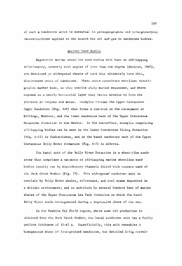
197
of such a sands tone u n i t s is e s s e n t i a l t o pa leogeographic and paleogeomorphic
r e c o n s t r u c t i o n s app l i ed t o t h e s e a r c h f o r o i l and gas i n sands tone bodies .
Ancient Sand Bodies
Regress ive marine s h o r e l i n e sand bod ies t h a t have an of f - lapping
r e l a t i o n s h i p , commonly wi th ang le s of less than one degree (Shel ton , 1965),
a r e developed as widespread s h e e t s of sand t h a t u l t i m a t e l y form t h i n ,
diachronous u n i t s of sands tone . These u n i t s c o n s t i t u t e e x c e l l e n t s t ra t i -
g raph ic marker beds , as they o v e r l i e s h a l y marine sequenees , and where
exposed as a n e a r l y h o r i z o n t a l l a y e r t hey resist e r o s i o n to form the
rim-rock i n canyons and mesas. Examples inc lude t h e Upper Cre taceous
Eagle Sandstone (Fig. 3-9) t h a t forms a rim-rock i n t h e escarpment a t
B i l l i n g s , Montana, and the lower sands tone beds of t h e Upper Cretaceous
Mesaverde Formation i n New Mexico. In t h e subsu r face , examples comprising
o f f - l app ing bod ies can b e seen i n t h e Lower Cre taceous Viking Formation
(Fig. 4-11) i n Saskatchewan, and i n t h e b a s a l sands tone u n i t of t h e Upper
Cre taceous Be l ly R ive r Formation (Fig. 4-7) i n A lbe r t a .
The b a s a l u n i t of t h e Be l ly River Formation i s a s h e e t - l i k e sand-
s t o n e t h a t comprises a sequence of o f f - l app ing marine s h o r e l i n e sand
bod ies l o c a l l y c u t by d i s t r i b u t a r y channels f i l l e d wi th c o a r s e r sand of
t h e Buck Creek Member (Fig. 73) . This widespread sands tone u n i t is
o v e r l a i n by Be l ly River s h a l e s , s i l t s t o n e s , and c o a l seams depos i t ed i n
a d e l t a i c environment; and is u n d e r l a i n by s e v e r a l hundred f e e t of marine
s h a l e s of t h e Upper Cre taceous L e a Park Formation on which t h e b a s a l
Be l ly River sands t r a n s g r e s s e d du r ing a r e g r e s s i v e phase of t h e sea .
In t h e Pembina O i l T i e l d r eg ion , where some o i l p roduct ion i s
ob ta ined from t h e Buck Creek Member, t h e b a s a l sands tone u n i t has a f a i r l y
uniform th i ckness o f 35-45 m. S u p e r f i c i a l l y , t h i s u n i t resembles a
homogeneous s h e e t of f ine-gra ined sands tone , bu t d e t a i l e d E-log c o r r e l -

198
a t i o n s (Fig. 4-7) show t h e i n t e r n a l s t r u c t u r e t o c o n s i s t of s e p a r a t e
sands tone bod ies o f f - l app ing t o t h e east , and ctit i n t o by d i s t r i b u t a r y
channels f i l l e d w i t h medium t o coarse-gra ined sand. Th i s sequence w a s
depos i t ed du r ing an eas tward r e g r e s s i o n of t h e sea i n response t o
p rograda t ion of a l a r g e d e l t a .
A t t h e c l o s e of Lea Park t i m e t h e Pembina r eg ion l a y under a
sha l low sea. Marine r e g r e s s i o n cont inued i n t o B e l l y R ive r t i m e , beg inning
w i t h t h e d e p o s i t i o n of b a s a l marine s h o r e l i n e sands . As t h e sea withdrew,
t h e marine s h o r e l i n e sands migra ted eas tward , forming an of f - lapping
sequence of s e p a r a t e sand bod ies . These w e r e followed and o v e r l a i n by a
d e l t a c o n s i s t i n g of d e p o s i t s formed i n bays , l agoons , e s t u a r i e s , c o a s t a l
marshes and r i v e r d i s t r i b u t a r i e s . These d e p o s i t s now form beds of
s ands tone , s i l t s t o n e , s h a l e and c o a l ove r ly ing t h e b a s a l sands tone u n i t
of r e g r e s s i v e s h o r e l i n e sands . The r e g r e s s i v e n a t u r e of t h i s sands tone
SEA LEVEL 7 7 -
S W A M P
M A R I N E S E D I M E N T S
OFFLAPPING MARINE SHORELINE
SANDS
Fig . 4-8. Diagram i l l u s t r a t i n g a c c r e t i o n of o f f l a p p i n g mar ine s h o r e l i n e
sands , such as t h e r e g r e s s i v e lower member of t h e Mesaverde
Sandstones (Upper Cre taceous) i n New Mexico. (Redrawn from
Hollenshead and P r i t c h a r d , 1961).

199
u n i t is r e f l e c t e d i n i t s g r a i n s i z e d i s t r i b u t i o n which t ends t o range from
f i n e above t o ve ry f i n e below, a g r a d a t i o n r e f l e c t e d i n t h e funnel-shaped
s e l f - p o t e n t i a l curve of t h e E-log (Fig. 4 - 7 ) .
The s p a t i a l r e l a t i o n s h i p s of such o f f - l app ing sands tone bodies
i s i l l u s t r a t e d wi th cons ide rab le v e r t i c a l exagge ra t ion i n F ig . 4-8, wi th
r e fe rence t o t h e i n t e r n a l s t r a t i g r a p h i c r e l a t i o n s h i p s of sands tone bod ies
i n t h e Mesaverde Formation.
r i s i n g o f f - l app ing sands tone bod ies formed as beaches , b a r s , and o t h e r
of f - shore sands , i s t h a t it w i l l , a l though widespread , have some degree
of l i n e a r i t y .
A g e n e r a l f e a t u r e of a sands tone u n i t comp-
O i l and G a s F i e l d s
S i g n i f i c a n t accumula t ions of o i l and gas a r e known w i t h i n r e g r e s s i v e
marine s h o r e l i n e sand bod ies . I n c o n t r a s t t o t r a n s g r e s s i v e marine s h o r e l i n e
F ig . 4-9. Schematic diagram i l l u s t r a t i n g types of sand bod ies formed
dur ing r e g r e s s i o n and subsequent t r a n s g r e s s i o n of a s ea .
g e n e r a l e v a l u a t i o n of pe t ro leum entrapment p o t e n t i a l is
i n d i c a t e d . (Af t e r MacKenzie, 1972, F i g . 5 ) .
A

200
s a n d s MacKenzie (1972) c o n t e n d s t h a t r e g r e s s i v e sand b o d i e s a r e less
a t t r a c t i v e a s e x p l o r a t i o n t a r g e t s . He s a y s , p. 57 , "During p e r i o d s of
o v e r a l l r e g r e s s i o n , s h o r e l i n e s a n d b o d i e s , i f p r e s e n t , may b e r e p l a c e d
updip by d e l t a i c d e p o s i t s (F ig . 4-9 t h i s t e x t ) . These d e l t a i c d e p o s i t s ,
b e c a u s e of t h e i r many a s s o c i a t e d t y p e s of sands - p a r t i c u l a r l y d i s t r i b u t a r y
c h a n n e l s a n d s - p r o b a b l y would b e r e l a t i v e l y poor b a r r i e r s t o up d i p
m i g r a t i o n .
In c o n t r a s t , d u r i n g p e r i o d s of o v e r a l l t r a n s g r e s s i o n , t h e s h o r e l i n e
s a n d b o d i e s would be r e p l a c e d updip by sand-poor l a g o o n a l muds which , when
compacted, would b e r e l a t i v e l y good b a r r i e r s t o updip m i g r a t i o n of o i l .
Fur thermore , t h e s a n d s would b e o v e r l a i n by mar ine s h a l e s , which s h o u l d b e
e f f e c t i v e b a r r i e r s " .
The c o r r e c t n e s s of t h i s c o n t e n t i o n i s open t o q u e s t i o n , as some
mar ine r e g r e s s i v e s a n d s t o n e b o d i e s are t h e r e s e r v o i r s f o r many o i l and
g a s f i e l d s . I m p o r t a n t examples i n c l u d e t h e Wattenberg Gas F i e l d producing
from t h e Lower C r e t a c e o u s "J" Sands tone of t h e Deaver Bas in i n Colorado , ,
and s e v e r a l f i e l d s p r o d u c i n g from t h e Lower C r e t a c e o u s Vik ing Formation
i n A l b e r t a and Saskatchewan.
Wattenberg Gas F i e l d , Colorado
The Wat tenberg G a s F i e l d c o v e r s an o v e r a l l area of a p p r o x i m a t e l y
2 ,500 s q u a r e k i l o m e t r e s . The f i e l d , which i s s i t u a t e d on t h e axis of t h e
Denver B a s i n , i s c o n s i d e r e d t o i n c l u d e s e v e r a l s t r a t i g r a p h i c t r a p s , t h e
g a s b e i n g c o n t a i n e d i n a b l a n k e t s a n d s t o n e u n i t , t h e Lower C r e t a c e o u s "3"
S a n d s t o n e , compr is ing r e g r e s s i v e mar ine s a n d s t o n e b o d i e s d e p o s i t e d i n t h e
f r o n t o f a n o r t h w e s t e r l y p r o g r a d i n g d e l t a . Entrapment of g a s i s c o n t r o l l e d
by d e c r e a s i n g p e r m e a b i l i t y a l o n g t h e edges o f t h e s a n d s t o n e b o d i e s .
Encountered w i t h i n t h e d e p t h r a n g e 2,200-2,600 m , t h e a v e r a g e n e t t h i c k n e s s
of t h e gas-bear ing s a n d s t o n e , o r pay , i s 8 m. Average p o r o s i t y i s 9.5%.

201
PRODUCTION EXCEEDING 500 BARRELS
BURBANK FIELD, OKLAHOMA
Fig . 4-10. D i s t r i b u t i o n of i n i t i a l d a i l y o i l p roduc t ion exeeeding 500
b a r r e l s p e r day p e r w e l l , Burbank and South Burbank f i e l d s ,
Osage and Kay Coun t i e s , Oklahoma, F i g u r e shows s p a t i a l
r e l a t i o n s h i p of p roduc t ion t o t h i c k e r p a r t s of curved,
l i n e a r bodies of Pennsylvanian sands tone depos i t ed as
s h o r e l i n e sands . Note en eche lon t r ends east of t h e main
c u r v i l i n e a r b e l t . (Redrawn from Bass , 1941).

202
Pe rmeab i l i t y , ave rag ing less than one m i l l i d a r c y , i s ex t remely low, and
gas f lows on ly a f t e r t h e sands tone has been f r a c t u r e d . A f t e r comple t ion ,
t h e average w e l l y i e l d s gas and 64O A . P . I . condensa te a t rates of 300-600
thousand cub ic f e e t and 10-20 b a r r e l s p e r day. Ul t imate gas product ion i s
e s t ima ted t o b e 1.3 t r i l l i o n (thousand b i l l i o n ) cub ic f e e t (36,400 m i l l i o n
cub ic met res ) over a 40 year p e r i o d , each w e l l on a 320-acre spac ing
producing 2 b i l l i o n cub ic f e e t .
Burbank O i l F i e l d , Oklahoma
Product ion i n t h e Burbank O i l F i e l d o f Oklahoma (Fig. 4-10) i s
ob ta ined from a number of Pennsylvanian sands tone bod ies t h a t form f o u r
p a r a l l e l and a r c u a t e t r e n d s , t h e c e n t r a l and n o r t h e r n t r e n d s showing an
en echeZon arrangement. These t r e n d s c o n s t i t u t e a b e l t , t h e t h i c k e r and
more p roduc t ive p a r t o f which has a wid th of 5 km and a l eng th of 25 km.
The sands tone bod ies range i n th i ckness up t o 30 m and c o n s i s t of w e l l -
- so r t ed g r a i n s which show a g rada t ion from f i n e i n t h e t h i c k e r p a r t s t o
ve ry f i n e n e a r the edges of t h e bod ies .
consequent ly conform t o t h e d e p o s i t i o n a l t r e n d s and a r e h i g h e r where t h e
sands tone i s t h i c k e r a long t h e axis of each body. I n t e r p r e t a t i o n of t h e
d e p o s i t i o n a l environment o f t h e s e sands tone bodies sugges t s (Bass, 1941)
t h a t t hey were depos i t ed as a sequence of o f f - l app ing beaches and b a r s
a long s h o r e l i n e t r e n d s t h a t migra ted t o t h e n o r t h e a s t .
t h e s e t r e n d s a l s o sugges t s t h a t they were developed as a p e r i p h e r a l
margin of s h o r e l i n e sands f l a n k i n g t h e prograding edge of a d e l t a l obe .
P o r o s i t y and pe rmeab i l i t y t r e n d s
The cu rva tu re of
I n i t i a l d a i l y p roduc t ion from some w e l l s exceeded 2,000 b a r r e l s
of o i l a day. Fig. 4-10 shows l i n e a r t r e n d s where t h e i n i t i a l d a i l y
p roduc t ion p e r w e l l exceeded 500 b a r r e l s a day.
i n c l u d i n g p a r t o f t h e South Burbank f i e l d , have y i e lded more than 40
m i l l i o n b a r r e l s (6 .4 m i l l i o n cub ic me t re s ) .
These p roduc t ion t r e n d s ,

203
Viking O i l and Gas F i e l d s , A l b e r t a and Saskatchewan
I n A l b e r t a and Saskatchewan, s e v e r a l f i e l d s produce o i l and gas
from t h e Lower Cre taceous Viking Formation. I n A l b e r t a , t h e main o i l f i e l d s
are t h e Joarcam, J o f f r e , Hamilton Lake, and Gilby-Bentley; t h e main gas
f i e l d s a r e t h e Vik ing-Kinse l la , P rovos t , B e a v e r h i l l Lake, Bindloss , Fa i ry-
d e l l , S e d a l i a , Cessford , and For t Saskatchewan. The main o i l and gas
f i r l d s i n Saskatchewan are t h e Mi l ton , Hoos ier , Smiley-Dewar, Whi tes ide ,
Colv i l le -Smi ley , Eureka, Beauf i e ld , Dodsland, and Avon H i l l . A l l of
t hese accumula t ions occur i n up-dip s e c t i o n s of l i n e a r and l e n t i c u l a r
sands tone bod ies , p a r t i c u l a r l y where s t r a t i g r a p h i c t r a p s have been
modified by c l o s u r e s r e s u l t i n g from d rap ing over h i l l s on t h e eroded
s u r f a c e of t h e Pa leozo ic , o r from d rap ing over s e c t i o n s f l anked by c o l l a p s e
f e a t u r e s r e s u l t i n g from t h e s o l u t i o n of s a l t l a y e r s w i t h i n t h e Pa leozoic .
The Viking Formation i s a d iachronous s t r a t i g r a p h i c u n i t , comprising
beds of sands tone and s h a l e , t h a t forms an a r c u a t e b e l t t r end ing nor th-
-wes ter ly a c r o s s sou the rn Saskatchewan and sou th -cen t r a l A lbe r t a . These
l i n e a r sands tone beds a r e markedly l e n t i c u l a r , l o c a l l y sepa ra t ed by s h a l e
l a y e r s , and s t r a t i g r a p h i c a l l y a r ranged as an o f f - l app ing sequence.
Deposited as s h o r e l i n e and near-shore sands i n a r e g r e s s i n g sea, they
formed beaches and o f f - sho re b a r s . The l i t h o l o g y and E-log cha rac t e r -
i s t i c s of t h e Viking sands tones are desc r ibed i n an e a r l i e r s e c t i o n of
t h i s chap te r . These sands tones a r e unde r l a in by marine s h a l e s of t h e
J o l i Fou Formation, which is the lowes t u n i t of t h e Lower Cre taceous
Colorado Group, and a r e o v e r l a i n by s h a l e s and s i l t s t o n e s of t h e same
group. In Saskatchewan, a minor d i sconfo rmi ty a t t h e base of t h e Viking
Formation i n d i c a t e s t h a t l o c a l l y t h e r e w a s wi thdrawal of t h e J o l i Fou sea
p r i o r t o d e p o s i t i o n of t h e Viking sands .
t h e Mannville Group ( s e e Carbon Gas F i e l d s , F ig . 5 - 9 ) , c o n s i s t s of dark
g rey , f i s s i l e , non-ca lcareous , b e n t o n i t i c s h a l e s wi th some lamina t ions
The J o l i Fou, which o v e r l i e s

204
SECTION ACROSS TREND OF V I K I N G FM., SASKATCHEWAN. "7
z
- E
0 M I L E S 3 - 0 K m 5
Fig . 4-11. La te ro log s e c t i o n E-El of t h e Lower Cre taceous Viking Formation
showing o f f - l app ing r e l a t i o n s h i p of sands tone members N , M ,
L 1 , Lu, and K through Eureka and Avon H i l l o i l and gas f i e l d s ,
Saskatchewan. Arrow i n d i c a t e s d i r e c t i o n of retreat of t h e
Colorado Sea . (Redrawn from Evans, 1970).
of s i l t s t o n e and ve ry f ine-gra ined sands tone .
a d i s t a n c e of 300 km, from 6 m nea r Calgary t o 30 m n e a r Edmonton, and
a l s o t h i c k e n s eas tward t o 45 m i n wes t - cen t r a l Saskatchewan. The fauna
i n t h e J o l i Fou c o n s i s t s mainly o f b i v a l v e s and arenaceous forams, sugg-
e s t i n g a shallow-water, near-shore mar ine environment.
It th i ckens nor thward , over
The o f f - l app ing r e l a t i o n s h i p of Viking sands tone bod ies is
i l l u s t r a t e d i n F ig . 4-11 which i s a s e c t i o n a c r o s s t h e Viking Formation
t r e n d i n t h e v i c i n i t y of t h e Eureka and Avon H i l l s f i e l d s i n Saskatchewan.
This t r e n d s t r i k e s west-southwest t o n e a r t h e Alberta-Saskatchewan boundary
where i t j o i n s t h e main Viking t r e n d i n a wide no r thwes te r ly - t r end ing arc.
The main p roduc t ion comes from t h e 'M' sands tone member shown i n F igs .
4-11 and 4-12. This member forms a l e n t i c u l a r r ibbon of sands tone , 10-20
km wide and up t o 8 m t h i c k , t h a t fo l lows a remarkably s t r a i g h t w e s t -
-southwest t r end f o r w e l l over 100 km. The 'M' member i s sepa ra t ed from
t h e under ly ing 'N' member (F ig . 4-11) by a b e n t o n i t e l a y e r which probably
o r i g i n a t e d as a f a l l of vo lcan ic a sh . Gra in g r a d a t i o n w i t h i n t h e 'M'

205
M I L E S 0
0 Km 10 I--r++A
ISOPACH M A P ' M I M E M B E R VIKING FM, SASKATCHEWAN
Fig . 4-12. Isopach map of 'M' member, Lower Cretaceous Viking format ion ,
i n a r e a of Hoos ier , Smiley-Dewar, Colv i l le -Smi ley , Eureka,
Beauf i e ld , and Dodsland o i l and gas f i e l d s , Saskatchewan.
(Redrawn from Evans, 1970).
l a y e r i s from f i n e r below t o c o a r s e r above. P o r o s i t y i n c r e a s e s i n t h e
t h i c k e r p a r t s o f t h e sands tone body, and p a r t i c u l a r l y improves i n t h e
c h e r t pebble zones.
d e p o s i t s on beaches , where c u r r e n t and wave a c t i o n has more v igo rous ly
winnowed t h e sed iments .
These pebble zones were probably formed a s l a g
O i l and gas accumula t ions w i t h i n the numerous sands tone bodies
of t h e Viking Formation are i n t h e more porous and permeable up-dip
s e c t i o n s .
t he t h i n n e r and l e s s permeable p a r t s up-dip may be o i l -bea r ing . F ig . 4 - 1 3
is an i sopach map of t h e net--producing sands tone of t h e Viking Formation
Thicker p a r t s of asands tone body may b e water -bear ing , whereas

206
N
Fig . 4-13. Isopach map of n e t producing sands tone body i n Lower Cret-
aceous Viking Formation, F o r t Saskatchewan gas f i e l d no r th -eas t
of Edmonton, A lbe r t a . Contour i n t e r v a l i n f e e t (1' = 0.305 m).
@drawn from White and Qrr , 1968).
i n t h e For t Saskatchewan Gas F i e l d . F ig . 4-14 i s a sand-percentage map
o f t h e Viking Formation i n t h e same a r e a , showing s t r u c t u r e contours
( f e e t below s e a l e v e l ) i n t h e gas f i e l d . The gas accumulation is n o t , i n
t h i s example, r e l a t e d t o t h e r a t i o of sands tone t o s h a l e w i t h i n t h e
fo rma t ion , bu t t o t h e up-dip p o s i t i o n of an i n d i v i d u a l sands tone body.
The n e t producing zone of t h i s sands tone body ranges i n th i ckness up t o
15 m , and has an average p o r o s i t y of 22%. Down-dip t h e Viking sands tones
a r e s a t u r a t e d wi th wa te r .
A s of e a r l y 1966, t he For t Saskatchewan Gas F i e l d a lone had y i e lded

MILES
207
n KM 6
Fig . 4-14. Sand-percentage map of Lower Cretaceous Viking'Formation,
F o r t Saskatchewan gas f i e l d , A l b e r t a , showing f i e l d area
( s t i p p l e d ) and Viking s t r u c t u r e contours (broken l i n e s ) i n
f e e t (1 ' = 0.305 m) sub-sea l e v e l . (Redrawn from White and
O r r , 1968).
more than 87 b i l l i o n (thousand m i l l i o n ) cub ic f e e t of gas from es t ima ted
r ecove rab le r e s e r v e s of 205 b i l l i o n (5,740 m i l l i o n cubic me t re s ) .
Es t ima tes of t o t a l gas i n i t i a l l y i n p l a c e i n t h e Viking sands tones of
A l b e r t a are p laced a t about 4 . 3 t r i l l i o n (thousand b i l l i o n ) cub ic f e e t ,
of which r ecove rab le r e s e r v e s are e s t ima ted t o be i n excess of 3 t r i l l i o n
(84,000 m i l l i o n cubic m e t r e s ) , which i s about 7% of t h e t o t a l r ecove rab le
gas r e s e r v e s i n A l b e r t a , a s of 1970. The e s t ima ted t o t a l o i l i n i t i a l l y
i n p l a c e i n t h e Viking sands tones of A l b e r t a is more than 320 m i l l i o n
b a r r e l s , of which 110 m i l l i o n (17.5 m i l l i o n cubic m e t r e s ) , r e p r e s e n t i n g
less than 1.5% of t h e i n i t i a l t c t a l r ecove rab le o i l r e s e r v e s i n A l b e r t a ,
may u l t i m a t e l y b e produced.
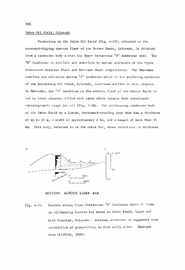
208
Sabre O i l F i e l d , Colorado
Product ion i n t h e Sabre O i l F i e l d (Fig. 4-15), s i t u a t e d on t h e
westward-dipping e a s t e r n f l a n k of t h e Denver Bas in , Colorado, i s ob ta ined
from a sands tone body w i t h i n t h e Upper Cre taceous "D" Sandstone u n i t . The
I, 11 D Sandstone is o v e r l a i n and u n d e r l a i n by marine sed iments of t h e Upper
Cre taceous Graneros Shale and Huntsman Shale r e s p e c t i v e l y . The Huntsman
o v e r l i e s t h e o f f - sho re marine "J" Sandstone which i s t h e producing sands tone
of t h e Wattenberg O i l F i e l d , Colorado, ncnt ioned ear l ier i n t h i s chap te r .
I n Nebraska, t h e "J" Sandstone on t h e e a s t e r n f l a n k of t h e Denver Basin is
c u t by r i v e r channels f i l l e d wi th sands which l o c a l l y form s t r u c t u r a l -
- s t r a t i g r a p h i c t r a p s f o r o i l (Fig. 1-50). The o i l - b e a r i n g sands tone body
of the Sabre F i e l d i s a l i n e a r , nor thward- t rending l e n s t h a t has a th i ckness
of up t o 15 m , a wid th o f approximate ly 2 km, and a l e n g t h of more than 15
km. This body, r e f e r r e d t o as t h e Sabre Bar, shows v a r i a t i o n s i n th i ckness
W E
0 1,800'
SECTION ACROSS SABER BAR
F ig . 4-15. Sec t ion a c r o s s Upper Cre taceous "D" Sandstone where it forms
an o i l -bea r ing b a r r i e r b a r known a s Saber F i e l d , Logan and
Weld Count ies , Colorado.
c o r r e l a t i o n of pe rmeab i l i t y i n f i v e wells shown.
from G r i f f i t h , 1966).
I n t e r n a l s t r u c t u r e i s sugges ted from
(Redrawn

209
along s t r i k e , so t h a t t h e geometry of t h e body i s t h a t of a connected s t r i n g
of pod-shaped, l e n t i c u l a r sandstone beds. The sandstone is micaceous and
very f ine-grained. Po ros i ty and permeabi l i ty a r e v a r i a b l e , t h e l a t t e r
ranging up t o 500 mi l l i da rcys . Reconstruct ion of t h e probable o r i g i n a l
shape of t h e Sabre sandstone body (Fig. 4-15) shows it t o be bar-shaped.
This i n t e r p r e t a t i o n is s u b s t a n t i a t e d by c o r r e l a t i o n of w e l l s ac ross the
body, which i n d i c a t e s t h a t t h e pe rmeab i l i t y inc reases upward, a cha rac t e r -
i s t i c a s soc ia t ed with b a r r i e r b a r s and o t h e r off-shore b a r s i n which t h e
g r a i n g rada t ion is from f i n e r below t o coa r se r above.
b
Wells in t h e Sabre F ie ld r e q u i r e hydrau l i c f r a c t u r i n g t reatment
i n o r d e r t o rpoduce o i l a t r a t e s o f 10-60 b a r r e l s p e r day, accompanied
by small flows of gas. Gas-oil and oi l -water con tac t s w i th in t h e sand-
s tone body appear t o be h o r i z o n t a l .

This Page Intentionally Left Blank

21 1
Chapter 5
TRANSGRESSIVE MARINE SHORELINE SAND
In t roduc t ion
Geomorphology
Transgressive marine s h o r e l i n e sand bodies a r e formed i n an inne r
n e r i t i c t o l i t t o r a l environment where t h e sea l e v e l i s r i s i n g r e l a t i v e t o
the land. The sand bod ies , which commonly coa le sce t o form discont inuous
s h e e t s of sand, grow landward over a d e l t a p l a i n o r an e r o s i o n a l su r f ace .
Depressions on t h e land s u r f a c e , such a s s t r i k e v a l l e y s f l ank ing cues t a s ,
are f i l l e d with sand.
sand may l eave only remnants w i th in these depressions. Where t h e remnants
a r e wi th in anc ien t s t r i k e v a l l e y s , t h e sand bodies form l i n e a r l e n s e s
p a r a l l e l t o t he s t r i k e of t h e underlying beds. These remnant, sand bodies
commonly tend t o be p a r a l l e l t o t h e s h o r e l i n e t r end of t h e sea i n which
they were deposi ted.
a c o a s t a l p l a i n o r f l a t e r o s i o n a l s u r f a c e , t h e i n d i v i d u a l sand bodies ,
formed a s beach r i d g e s , a l s o t r end along t h e coas t . Recognition of t h e
o r i g i n of sand bod ies , and t h e na tu re of t h e i r l i n e a r i t y , is e s s e n t i a l
t o r econs t ruc t ion of t h e paleogeographic and paleogeomorphic s i t u a t i o n s
t h a t may have a bea r ing on exp lo ra t ion f o r o i l and gas.
Se l l ey (1970, p. l l l ) , "Obviously a considerable understanding not only
of sedimentology but a l s o of geomorphology i s needed t o p r e d i c t t h e
l o c a t i o n of hydrocarbon r e s e r v o i r s i n t h e b a s a l sands of t r a n s g r e s s i v e
c l a s t i c sho re l ines" .
Subsequent e ros ion of a t r a n s g r e s s i v e shee t of
Where a shee t - l i ke complex of sand bodies t r ansg res ses
A s s t a t e d by
A d i s t i n c t i o n is drawn between sand bodies t r ansg res s ing over a
d e l t a p l a i n o r e r o s i o n a l su r f ace and sand bod ies , s i t u a t e d on a cont in-

212
ental shelf many miles from land, that are prograding toward the coast.
An example of the latter type is the Upper Cretaceous Eagle Sandstone of
Montana (Fig. 3-9). This sandstone unit exhibits all the characteristics
of a barrier bar complex, but was apparently growing toward a coast
situated more than 50 miles away (Shelton, 1965). A further distinction
must be drawn where transgressing marine sands over-ride alluvial sands.
There are examples where alluvial sand bodies have been mistaken for
marine sand bars, because of their shape. A case in point is the Lower
Cretaceous Ellerslie Sandstone in the Bellshill Lake Oil Field, Alberta
(Figs. 39 and 4 0 ) .
originally thought to be a sand bar flanked by marine to brackish-water
silty muds and limey beds containing forams and ostracods. Conybeare
(1964, 1972) and Martin (1966) showed the sandstone body to be a remnant
of an eroded alluvial terrace situated in a broad valley that was inundated
by brackish-water as the sea advanced southward. Other examples, where
interpretations of depositional environment must proceed with caution, are
cited by Selley (1970, p. 110) and Levorsen (1967, p. 336-337). Selley
cites Levorsen's references to the Lower Cretaceous Cutbank Sandstone of
Montana, and the basal sandstone of the Pliocene Quirequire Formation,
Venezuela, as examples of transgressive sand units. Both units are of
non-marine origin, the Cutbank filling channels of an ancient drainage
system (Fig. 1-51).
The producing sandstone body in this field was
Transgressive sheet-like units of marine sand are comparatively
Where transgression takes place over a delta the thin and widespread.
sands overlie coastal-marsh peat, bay muds, and distributary sands.
Where transgression is over an unconformity the sands overlie eroded
rocks, soils, and alluvial or lacustrine sediments. Transgressive sand
units are formed from the re-working of pre-existing sediments and soils,
from the erosion of sandstone headlands cropping out along beaches, and

213
from the accretion of sand carried from river mouths by longshore currents.
The last factor is probably of minor importance in a transgressive
situation in which the sediment load carried to the sea is probably
much lighter than in the regressive phase. The lower rate of sedi-
mentation in transgressive units results in a greater degree of
winnowing of the sediment, comparative thinness of the unit, and in
some situations is also reflected in a relatively high quartz content
of the sands.
E-log Characteristics
Transgressive, sheet-like units of sand are built up by the
gradual encroachment of a beach upon a land surface.
facilitated where the land surface is low-lying with respect to sea
level, such as on delta plains and other coastal lowlands. The
encroaching sand body includes a beach exposed at low tide and a
broad, sub-sea extension of the beach. Landward, in the zone of
strongest wave action, the beach sand is a mixture of coarser grain
sizes. Seaward, in deeper and quieter water, finer-grained sand is
deposited. In still deeper water, the sand grades into silts and muds
which, with continuing transgression of the beach, progressively buries
the sand unit. The physical principle involved in the differential
deposition of sand grains on a transgressive beach is the same as that
previously described with reference to the development of a prograding
barrier bar, except that in the former case, the depositional front is
migrating landward, and in the latter seaward.
Encroachment is
Grain gradation within a transgressive sandstone unit is from
finer above to coarser below. The same gradation is found in river
sand deposits such as channel-fill and point bar sand bodies. For this
reason, caution is necessary in the interpretation of some basal

214
sandstone units, and may in part explain why a sandstone such as the
Lower Cretaceous Cutbank Sandstone of Montana should have been referred
to as a transgressive unit (Selley, 1970, p. 110). Grain gradation is
not always evident, but where present is commonly reflected in the bell-
-shaped self-potential curve of the E-log. These characteristics of
transgressive sands are illustrated by Pirson (1970) in diagrams combining
self-potential curves and dipmeter plots. They are also shown by Pate
(1959) in E-log sections of the stratigraphic interval including the
transgressive Pennsylvanian Tonkawa Sandstone of the Anadarko Basin,
Oklahoma. Pirson further shows theoretical self-potential curves of the
regressive Point Lookout Formation and transgressive Cliff House Formation
of the Upper Cretaceous Mesaverde Group in the San Juan Basin of New
Mexico. These formations merge laterally, passing upward from a regressive
to a transgressive phase. Pirson states that the rapidity of transgression
can be gauged by the accentuation of the bell-shaped self-potential curve.
The accentuation is indirectly a measure of the degree of grain gradation
effected by winnowing which will be greater under more vigorous energy
conditions such as those existing along the shoreline of a rapidly
advancing sea.
Compaction
Transgressive marine shoreline sand bodies are comparatively thin
and widespread. They are deposited on the land surface of a coastal plain
which may be an erosional surface or the depositional surface of a delta.
Where the transgressive sand unit is lying on eroded rocks, compaction of
the overlying beds will have little or no effect on its geometry. The
important factor controlling the original geometry is the configuration of
the surface on which the sands are deposited. Subsequent erosion of the
overlying beds and of the sandstone unit itself will modify its geometry,
leaving isolated sandstone bodies such as wedges, strike valley lenses,

215
and sandstone patches in the older topographic depressions. Where
erosion of the underlying beds occurs, remnants of the sheet-like trans-
gressive sandstone unit may be left as cap rock on buttes and mesas.
Cessation of uplift and erosion, subsequent transgression of the sea, and
burial of the individual residual sandstone bodies by fine-grained
estuarine and marine sediments may result in the formation, by compaction
of the overlying sediments, of a number of potential reservoirs for oil
and gas.
Where the transgressing sand unit is lying on poorly consolidated
to unconsolidated sediments, such as clays and silts underlying the
surface of a delta coastal-plain, compaction of these underlying beds
may have a marked effect on the subsequent geometry of the unit. Gentle
variations in the dip of the sheet-like sand unit may reflect differences
of sand-mud ratio in various parts of the underlying pile of sediments
undergoing compaction. More accentuated variatic IS in dip may reflect
local draping of underlying clays over a deeper body of sand Fuch as a
barrier bar. Other factors influencing variations in the post-depositional
dip of a transgressive sand unit are compaction of the underlying pile of
sediments over basement topographic features, and penecontemporaneous
faults caused by mass slumping within the underlying section. The latter
may result in local deformation of the transgressive sand unit to form
monoclinal structures.
Ancient Sand Bodies
A classic exmaple of a transgressing sand is the Ordovician St.
Peter Sandstone of Minnesota. This friable sandstone is composed entirely
of well-rounded grains of quartz having a fairly uniform size. The
rounded quartz grains are pitted, a feature that has been regarded as
indicative of an eolian origin. The sandstone, as a unit, is remarkably
sheet-like; it has an average thickness of 23 m but ranges up to 90 m,

and covers an area of approximately 575,000 sq. km according to Dapples
(1955). The St. Peter is associated with shelf carbonates and was regarded
by Dapples as a continuous series of coalescent shoreline sands migrating
over a stable shelf. The Devonian Oriskany Sandstone of West Virginia,
a quartz arenite cemented by quartz to form an orthoquartzite, is also
considered to be a transgressive sandstone unit. These examples are
probably exceptional in that they are composed entirely of quartz grains,
although in general it can be said that transgressive sands are commonly
quartzose. Regressive sands are commonly lithic, but can also be quartzose,
as is the case with some present-day beach sands in the Gulf of Mexico.
The composition of river sands is a mixture of quartz and lithic grains,
with the former commonly predominant.
The origin of sands composed entirely of quartz grains is by no
means certain.
stones, from sand dunes, or from pre-existing sands. It is probable that
the sand grains in all such quartz sands have been re-cycled several times.
Arguments bearing on this problem are discussed by Pettijohn, Potter, and
Siever (1972, p. 224-225).
They may have formed from the erosion of quartzose sand-
Another classic example of a transgressive marine sandstone is the
Lower Cambrian Tapeats Sandstone exposed in the Grand Canyon of Arizona.
The Tapeats overlies Precambrain rocks, and is overlain by marine shales
of the Middle Cambrian Bright Angel Formation. Referring to the great
unconformity on which the Tapeats rests, McKee (1969, p . 79) says, "Its
record is plainly seen from many vantage points on the canyon rims, but
it is perhaps even more impressive where observed from closer sites along
the Colorado.
surface for a distance of miles; it bevels the upturned ends of schists
and other metamorphic rocks of early Precambrian time and is covered by
flat-lying strata of the Cambrian. Elsewhere it is seen as cross sections
In places this unconformity is a remarkably flat, even

21 7
of rugged h i l l s o r r i d g e s , some hundreds of f e e t h igh , of l a te Precambrian
q u a r t z i t e s and o t h e r r e s i s t a n t rocks , surrounded by and b u r i e d benea th
sed iments depos i t ed i n t h e Cambrian sea".
by t h i s unconformity is c i t e d by McKee, a f t e r estimates by Sharp ( 1 9 4 0 ) , t o
be 100 m i l l i o n yea r s .
The g r e a t span of t i m e r ep resen ted
The Tapea ts Sandstone i s desc r ibed by McKee (1969, p. 80) as fo l lows .
"The Tapea ts Sandstone is a massive, c l i f f - fo rming u n i t w i th a
th i ckness ranging from 100 t o 300 f e e t th roughout t h e canyon area. In
most p l a c e s i t i s choco la t e brown, bu t i n some p l a c e s i t is g rey o r cream-
-coloured and i n o t h e r s , a deep r e d brown. The sand i s coa r se t o medium
g ra ined ; coa r se p a r t i c l e s are dominant except i n p a r t s of t h e upper h a l f ,
where medium-size g r a i n s are more common. Bedding is conspicuous because
of c o n t r a s t s i n degree of cementa t ion t h a t cause l a y e r s t o weather i n t o
a l t e r n a t i n g r e s i s t a n t l edges and sha l low recesses. F l a t , even beds up t o
a few inches t h i c k a r e common, bu t by f a r t h e more abundant s t r u c t u r a l
f e a t u r e s is crossbedding w i t h i n l a y e r s ranging i n t h i c k n e s s from 4 t o 2
f e e t . Most c r o s s - s t r a t a are t a b u l a r p l a n a r o r wedge p l a n a r bu t l o c a l l y
some are of t rough type . Asymmetrical r i p p l e marks, t r i l o b i t e t ra i l s , and
p rob lema t i ca l worm bor ings are wide ly d i s t r i b u t e d and numerous a t some
l o c a l i t i e s . In many p l a c e s t h e Tapea ts grades upward i n t o t h e Br ight
Angel through a zone i n which coa r se sands tone beds a l t e r n a t e wi th green
s h a l y muds tones".
O i l and Gas F i e l d s
Transg res s ive marine s h o r e l i n e sand bod ies are known t o c o n t a i n
o i l and g a s , a l though more examples areknown i n r e g r e s s i v e sands .
MacKenzie (1970) has advanced t h e i d e a t h a t t h e percentage of good t r a p s
i n t r a n s g r e s s i v e sands tones should be h ighe r than i n r e g r e s s i v e sands tones ,
because t h e former are o v e r l a i n by less permeable marine s h a l e s , whereas

218
the latter are overlain by delta sands and silts which on compaction
would form a less effective seal. Argued on this basis MacKenzie has a
point, although it can be said that on the basis of statistics, the number
of known oil and gas reservoirs in regressive sandstone bodies considerably
exceeds the number known in transgressive bodies. A factor that probably
has considerable relevance to the hydrocarbon potential of transgressive
and regressive sedimentary sequences is the relative amounts of organic
matter incorporated with the sediments. In regressive sequences the
river systems drain large areas and carry organic matter as colloids and
macerated plant fragments. This organic matter is carried to the sea
where the macerated plant remains are deposited and the colloids are
precipitated by intermingling of fresh and salt water.
sediments deposited in brackish-water bays and coastal swamp environments
are rich in organic matter, both plant and animal.
on the other hand, are commonly deposited over flat coastal areas that
border on lowlands from which little sediment or organic matter is being
Also, the delta
Transgressive sequences,
derived. The transgressive nature of the coastline itself, subject to
active erosion by wave action, is not conducive to the growth of coastal
swamps, nor to the many forms of organisms that thrive in more protected
environments. Furthermore, high energy environments are not conducive to
the retention of organic matter in muds.
A third consideration is the nature of the surface over which the
sand unit is transgressing. Where the surface is erosional and underlain
by consolidated material and bedrock, the source of oil or gas that
subsequently becomes entrapped in the transgressive sand unit is probably
within the overlying marine sediments. But where the surface is a delta
plain underlain by unconsolidated, organic-rich muds and silts, the
source may be either the underlying deltaic sequence of the overlying
marine sediments.

21 9
It is of interest to note that the first significant flow of oil
in Australia, although not the first discovery, was obtained in 1953 from
a Lower Cretaceous transgressive unit in Western Australia, the Birdrong
Sandstone.
oil at rates of up to 600 barrels per day, but later proved to be non-
-commercial. The accumulation within the Birdrong, a sheet-like sandstone
unit unconformably overlying Jurassic and older rocks, is located in a
structure formed by draping of the sandstone over an elongate buried hill.
The Birdrong, a clean quartzose sandstone, is glauconitic in its upper
part. It has good porosity and permeability and is the main fresh-water
artesian aquifer in the Carnarvon Basin.
The well, Rough Range No. 1, initially flowed 30' A.P.I. waxy
Yardarino-Dongara Gas Field, Western Australia
In the Yardarino-Dongara Field of Western Australia gas and oil are
produced from the basal Yardarino Sandstone of the Lower Triassic Kockatea
Formation. This sandstone, which lies unconformably on Precambrian and
Permian beds, is a transgressive marine unit.
quartzose, very fine to coarse-grained sandstone with conglomeratic layers.
In the field area the sandstone is about 55 m thick and is overlain by
marine shales. Porosity ranges up to 25% but averages about 17%; permeability
ranges up to several thousand millidarcys, but is comonly in the range
100-700 millidarcys .
It consists 0) light grey,
The field is essentially a structural-stratigraphic trap, the
Yardarino Sandstone showing marked thinning over a basement erosional
high. Production consists mainly of gas containing approximately 97%
methane, with a condensate content of up to 15 barrels per million cubic
feet of gas, and minor quantities of 35' A.P.I. waxy oil. Producible
gas reserves are estimated (Cope, 1972) to be in the order of 500,000
million cubic feet (14,000 million cubic metres) containing a minimum

220
of 500,000 b a r r e l s (79,500 cub ic met res ) of condensa te . Formation water
unde r ly ing t h e g a s and o i l is b r a c k i s h t o s a l t y .
Red Oak, Wi lber ton , and Kin ta Gas F i e l d s , Oklahoma
Gas product ion i n t h e Red Oak, Wi lber ton , and Kin ta f i e l d s of t h e
McAl is te r Bas in , Oklahoma, is ob ta ined from sands tones a t t h e b a s e , and
i n t h e lower s e c t i o n of t h e Lower Pennsylvanian Atoka Formation. The
b a s a l s ands tones , termed t h e F o s t e r Sand, c o n s i s t o f fou r s e p a r a t e b e l t s
t r e n d i n g t o t h e s o u t h e a s t (F ig . 5-1). These l i e unconformably, i n
e r o s i o n a l d e p r e s s i o n s , on l imes tones and s h a l e s of t h e Pennsylvanian
Wapanucka Formation. The Fos t e r Sand, which has a t h i c k n e s s of up t o 9 m ,
is composed predominantly of well-rounded, f i n e t o medium q u a r t z g r a i n s .
N
0 20
K M
DLSTRIBUTARY A N D S H O R E L I N E S A N D
T R E N D S , P E N N S Y L V A N I A N A T O K A F M ,
O K L A H O M A
F i g . 5-1. Fos te r Sand t r ends 1 , 2 , 3 and 4 , formed as d i s t r i b u t a r i e s
f i l l i n g e r o s i o n a l d e p r e s s i o n s , o v e r l a i n by no r theas t - t r end ing
s h o r e l i n e Sp i ro Sand ranging i n th i ckness t o 100 f e e t (30 m).
The F o s t e r i s t h e lowes t number of t h e Lower Pennsylvanian
Atoka Formation, Mdl i s t e r Bas in , e a s t e r n Oklahoma. (Redrawn
from Lumsden, P i t tman and Buchanan, 1 9 7 1 ) .

221
It i s commonly cross-bedded and c o n t a i n s s h a l e c l a s t s and f ragments of
f o s s i l wood. The o r i g i n of t h i s b a s a l sands tone u n i t is e v i d e n t l y
a l l u v i a l , t h e sands having been depos i t ed i n a system of p a r a l l e l r i v e r
d i s t r i b u t a r i e s t h a t t rended s o u t h e a s t a c r o s s a c o a s t a l p l a i n t h a t w a s a t
l e a s t 60 km i n wid th . Some gas p roduc t ion , i n c l u d i n g t h a t of t h e Kin ta
F i e l d , i s ob ta ined from t h e F o s t e r Sand.
The F o s t e r Sand is o v e r l a i n by t h e S p i r o Sand, a t r a n s g r e s s i v e
marine u n i t up t o 30 m t h i c k . The Sp i ro forms an e l o n g a t e sands tone u n i t
t h a t t r e n d s southwes t , normal t o t h e F o s t e r t r e n d , f o r more than 100km.
The Sp i ro Sand is a l s o q u a r t z o s e , p robably having been i n l a r g e p a r t
de r ived from t h e F o s t e r Sand. I t i s moderately w e l l s o r t e d , and ve ry
f i n e t o f ine -g ra ined . A s a whole, t h e Spi ro is r e f e r r e d t o as a b l anke t
s ands tone b u t c o n s i s t s of mass ive , l e n t i c u l a r beds , depos i t ed as s h o r e l i n e
sand b o d i e s , i n t e rbedded wi th t h i n l a y e r s of s i l t y sands tone and s h a l e .
Low-angle cross-bedding and b i o t u r b a t i o n have been desc r ibed , t h e former
probably r e s u l t i n g from v a r i a t i o n s i n d e p o s i t i o n a l s l o p e s of ,the seaward
ex tens ions of beaches .
The Sp i ro Sand, which t r ansg res sed t o t h e no r thwes t , is n o t uniformly
developed, some l o c a l i t i e s a long i t s t r end be ing t h i c k e r and more permeable.
Dry gas accumula t ions , which are l a r g e l y r e l a t e d t o s t r a t i g r a p h i c c o n t r o l ,
i nc lude t h e Red Oak and Wilburton F i e l d s .
Morrow O i l F i e l d s , Oklahoma
O i l p roduc t ion from s e v e r a l f i e l d s i n t h e Anadarko Basin of
Oklahoma is ob ta ined from t h e Cherokee Sandstone, t h e b a s a l u n i t of t h e
Lower Pennsylvanian Morrow Formation. The Cherokee, which l i e s unconfor-
mablg on M i s s i s s i p p i a n beds of l imes tone and s h a l e (F ig . 5-Z), is a
marine t r a n s g r e s s i v e u n i t t h a t forms a co r ruga ted s h e e t of sands tone
comprising p a r a l l e l t r e n d s a long which t h e sands tone is t h i c k e r .
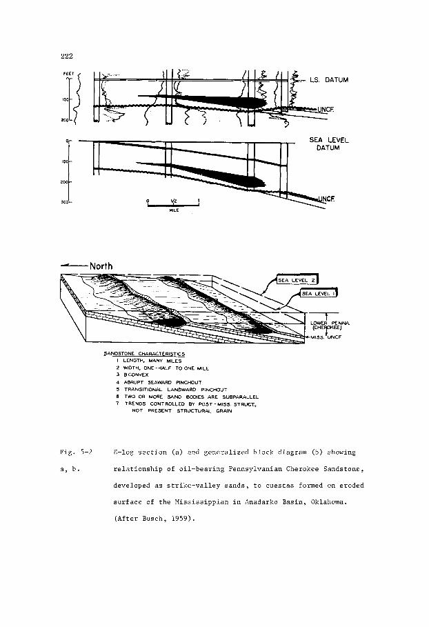
222
-. LS. DATUM
200
SEA LEVEL
MILE
North L
SANDSTONE CHARACTERISTICS I LENGTY MANY MILES
2 WIDTH, ONE -HALF TO ONE MILE
3 BICONVEX
4 ABRUPT SEAWARD PINCHOUT
5 TRANSITIONAL LANDWARD PINCHOUT
(I TWO OR MORE SAND BODIES ARE SUBPARALLEL
7 TRENDS CONTROLLED BY W S T - M I S S . STRUCT,
NOT PRESENT STRUCTURAL GRAIN
Fig . 5-2 E-log s e c t i o n (a ) and gene ra l i zed b lock diagram (b) showing
a , b . r e l a t i o n s h i p of o i l -bea r ing Pennsylvanian Cherokee Sandstone,
developed as s t r i k e - v a l l e y sands , t o c u e s t a s formed on eroded
s u r f a c e of t h e Miss i s s ipp ian i n Anadarko Bas in , Oklahoma.
(Af t e r Busch, 1959).

223
Depending on whether the top or bottom of the sandstone unit is taken as
a datum, these thick trends appear respectively as topographic depressions
or as ridges. The interpretation placed on them by Busch (1959) is that
they are bar-shaped sand bodies deposited in erosional depressions at the
base of cuestas formed by unequal erosion of outcropping layers of
limestone and shale.
Busch (1959, p. 2832) says, "Strike valley sands derive their name from
the fact that they are deposited in the low areas between cuestas at the
As such, they can be defined as strike valley sands.
rig. 3 - 3 . isopacn map or incervai LaDove (+) or below ( - ) J between a
datum and the top of a sandstone unit in the Pennsylvanian
Morrow Formation, northwestern Oklahoma. Figure shows
known (black) and inferred (hatchured) oil fields developed
where sand ridges are intersected by northwest-plunging folds.
(After Busch , 1959).

224
time the land surface is inundated by a transgressive sea. Such cuestas
may be either erosional escarpments or fault-scarps.''
These thick, linear sandstone bodies are lenticular in section,
ranging in width up to 3 km,in thickness to 1 5 m, and in length to 65 km.
They terminate fairly abruptly along the thicker edge where they merge
into a shale facies, the landward edge pinching out on the flank of each
cuesta. These parallel sandstone lenses are intersected by northwest-
-plunging folds which form structural closures within the sandstone at
some of the intersections. Within these closures oil has accumulated to
form two parallel strings of separate pools (Fig. 5 - 3 ) .
Milligan Oil Field, British Columbia
In the Milligan Oil Field of northeastern British Columbia,
production is obtained from the Upper Triassic Halfway Sandstone. The
Halfway unconformably overlies silty dolomite beds of the Doig Tormation,
and is overlain conformably by silty dolomite beds of the Charlie Lake
Formation (Fig. 5-6). It has a linear northwest trend and is lenticular
in section (Figs 5-4 , 5 - 5 ) . In the field area this trend, which bifurcates
into two parallel but connected sub-trends, is known to have alength of
more than 80 km.
overall width of the main trend ranging up to 10 km.
Each sub-trend has a width of approximately 3-5 km, the
In the Milligan Field the gross thickness of the Halfway ranges
up to 15 m. The sandstone is quartzose and fine to very fine-grained,
except at the base which is commonly gritty. The grains are sub-angular
to sub-rounded. Porosity ranges up to 28%, but averages 2 2 % , and
permeability is in the range 400-600 millidarcys (Clark, 1 9 6 1 ) . The
E-log (Fig. 5-6) of the Halfway is characterized by a blocky, slightly
bell-shaped self-potential curve. Both top and bottom boundaries are

225
F i g . 5-4. I s o p a c h map o f t h e o i l - b e a r i n g Upper T r i a s s i c H d f w a y Sands tone ,
B r i t i s h Columbia. S t r u c t u r e c o n t o u r s show t h e c o n f i g u r a t i o n of
t h e b a s e of t h e s a n d s t o n e . (Redrawn from M o t h e r s i l l , 1968) .
loo,..
0 MILES
o - - - 4 K M
MILLIGAN FIELD
L I.
NORTH 4
I
4 1
B C
F i g . 5-5. S t r a t i g r a p h i c s e c t i o n t h r o u g h t h e X i l l i g a n F i e l d , B r i t i s h
Columbia, showing i n f e r r e d c o n f i g u r a t i o n of t h e o i l - b e a r i n g
Upper T r i a s s i c Halfway Sands tone a t t h e t i m e of d e p o s i t i o n .
(Redrawn from C l a r k , 1961) .

226
UNION- H B d - 5 4 - G
1 1 CHARLIE LAKE FM
E -LOG, MlLLlGAN FIELD
Fig. 5-6. Typ ica l E-log of t h e Upper T r i a s s i c Halfway Sandstone
i n t e r v a l i n Union - H.B. d-54-G, Y i l l i g a n F i e l d , B r i t i s h
Columbia, showing t h e blocky c h a r a c t e r i s t i c of t h e s e l f -
p o t e n t i a l cu rve , and t h e o i l -wa te r con tac t . (Redrawn from
C l a r k , 1961).
sha rp . The b locky c h a r a c t e r r e f l e c t s t h e e x c e l l e n t s o r t i n g of f i n e - t o
ve ry - f ine q u a r t z g r a i n s , and t h e s l i g h t d e f l e c t i o n a t t h e base r e f l e c t s
a t h i c k g r i t t y l a y e r .
beds commonly d ipping a t ang le s of less than 20° ( M o t h e r s i l l , 1968).
The ampl i tudes of t h e cross-beds range from less than an inch t o s e v e r a l
i n c h e s , p l a c i n g them i n t h e sma l l t o medium s i z e ca t egory (Conybeare and
Crook, 1968) of r i p p l e s formed by c u r r e n t s . In t h e sou the rn p a r t of t h e
Halfway Sandstone t r e n d , i n t h e v i c i n i t y of t h e Pee jay and Curran t o i l
f i e l d s , t h e upper p a r t of t h e Balfway, which is t h e o i l -bea r ing s e c t i o n
i n t h e s e f i e l d s , c o n t a i n s t h i n beds of coquina c o n s i s t i n g mainly of
b i v a l v e s h e l l s .
Cross-bedding i s a n o t a b l e f e a t u r e , t h e f o r e s e t
In t h e Mi l l i gan F i e l d area t h e Doig Formation, which unconformably
u n d e r l i e s t h e Halfway Sandstone, d i p s southwest a t 7 m/km, whereas t h e

221
Halfway d i p s southwest a t about 5 m/km. Th i s r e l a t i o n s h i p sugges t s t h a t a t
t h e t i m e of d e p o s i t i o n of t h e Halfway, t h e Doig beds must have had a
sou thwes te r ly d i p of about 2 m/km.
o u t a long t h e f o o t h i l l s of n o r t h e a s t e r n B r i t i s h Columbia and th i ckens
southwestward i n t h e subsu r face . Although t h e Halfway w a s depos i t ed as
an i r r e g u l a r s h e e t of s and , du r ing a pe r iod of marine t r a n s g r e s s i o n t o
t h e n o r t h e a s t , i t s l i n e a r t r e n d s , cur ren t -bedding c h a r a c t e r i s t i c s , and
c o a r s e r b a s a l l a y e r raises problems concern ing t h e r e l a t i o n s h i p s of t h e
sand body geometry t o i t s pa leogeographic s e t t i n g . I n p a r t i c u l a r , i t is
p e r t i n a n t t o know whether , i n t h e ' 4 i l l i gan F i e l d area, t h e sands tone t r ends
r e p r e s e n t d e p o s i t i o n as s h o r e l i n e sand b a r s o r a s d i s t r i b u t a r i e s . The use
of s e v e r a l datums i n t h e c o n s t r u c t i o n of s t r a t i g r a p h i c s e c t i o n s d e p i c t i n g
t h e d e p o s i t i o n a l r e l a t i o n s h i p s o f t h e Halfway sugges t d i f f e r e n t poss i -
b i l i t i e s . Probably t h e most r easonab le i n t e r p r e t a t i o n (C la rk , 1961),
u s ing a datum j u s t above t h e Halfway, shows t h e sand bod ies f i l l i n g
dep res s ions , i n t e r p r e t e d as s t r i k e - v a l l e y s , i n t h e under ly ing Doig
Formation. Pa ra l l e l sub- t rends of t h e Halfway i n t h e Mi l l i gan F i e l d
area are thought t o have r e s u l t e d from concen t r a t ion of sand i n s e p a r a t e
s t r i k e - v a l l e y s between c u e s t a s a long t h e coas t . Subsequent s t r u c t u r a l
deformat ion of t h e s e t r e n d s has formed s e v e r a l t r a p s f o r o i l , i nc lud ing
t h e M i l l i g a n F i e l d .
The lower p a r t of t h e Halfway crops
Horseshoe O i l F i e l d , New M e x i
The Horseshoe F i e l d of t h e San Juan Bas in , New Mexico, y i e l d s o i l
from t h e b a s a l sands tone u n i t of t h e Upper Cretaceous Niobrara Formation.
This s ands tone l i e s unconformably on g e n t l y fo lded beds of sandy s h a l e , and
l imes tone which c o n s t i t u t e p a r t of t h e Upper Cre taceous Gallup and C a r l i l e
Formations. D i s t r i b u t i o n of t h e sands tone shows a marked p a r a l l e l i s m of
l e n t i c u l a r t r e n d s , r e s u l t i n g from concen t r a t ion of t h e o r i g i n a l sand i n
s t r i k e v a l l e y s f l a n k i n g c u e s t a s formed by d i f f e r e n t i a l e r o s i o n of s h a l y
and sandy beds benea th t h e unconformity (F igs . 5-7 and 5-8).

228
KM 0 F E E T 0 1
1
M I L E
C R O S S - S E C T I O N S OF B A S A L NIOBRARA SANDSTONE
H O R S E S H O E FIELD, N E W MEXICO
Fig. 5-7. S t r a t i g r a p h i c c ros s - sec t ions of t h e Upper Cretaceous b a s a l
Niobrara Sandstone i n t h e Horseshoe o i l f i e l d , San Juan Basin,
New Mexico.
eroded s u r f a c e of t h e Gal lup Formation and C a r l i l e Formation
The sand bod ies w e r e formed along cues t a s on t h e
during cransgression of the Niobrara sea. (&dram from
P e n t t i l a , 1964).
Work by P e n t t i l a (1964) and McCubbin (1969) e s t a b l i s h e d t h e
d e p o s i t i o n a l and s t r a t i g r a p h i c r e l a t i o n s h i p s of t he b a s a l Niobrara Sand-
s tone which they b e l i e v e t o have been depos i t ed as a s h o r e l i n e sand by a
t r a n s g r e s s i v e sea.
f a c t t h a t t h e unconformity which underl ies the Niobrara and b e v e l s t h e Gallup,
w a s p rev ious ly no t recognized.
w a s thought t o be equ iva len t t o t h e b a s a l Gallup Sandstone.
t h a t i n d i v i d u a l sandstone bodies are l o c a l i z e d on t h e seaward s i d e of
c u e s t a s , t h e s t e e p e r s lopes of which faced seaward.
t h e s e cues t a s formed r i d g e s which temporar i ly impeded t r a n s g r e s s i o n ,
r e s u l t i n g i n a s t a t i o n a r y s h o r e l i n e , w i th t h e consequent depos i t i on of
a t h i c k e r body of sand.
The importance of t h i s i n t e r p r e t a t i o n l ies i n t h e
Consequently, t h e b a s a l Niobrara Sandstone
McCubbin says
A s t h e sea advanced,

229
Fig. 5-8. Generalized diagram showing the stratigraphic relationship
of the Upper Cretaceous basal Niobrara Sandstone to cuestas
and strike-valleys formed on the eroded surface of the Upper
Cretaceous Carlile Formation during transgression of the
Niobrara sea. (Modified by MacKenzie, 1972, after McCubbin,
1969).
The basal Niobrara Sandstone in the Horseshoe Field area comprises
three units which lie in different stratigraphic positions resulting from
deposition against separate ridges at various times during the overall
period of marine transgression. The oldest unit is the lower reservoir
in the Horseshoe Field.
distance of more than 40 km.
trend has a width of 6 km, and a thickness of up to 15 m. It divides
to the northwest into two separate oil-bearing trends, the Many Rocks and
Mesa, each of which has a width of about 2 km.
This sandstone body strikes southeast for a
The main sandstone body in the Horseshoe

230
The Niobrara is t e x t u r a l l y v a r i a b l e , grading from f i n e t o coarse-
-grained. Average p o r o s i t y and pe rmeab i l i t y a r e 15% and 175 mi l l i da rcys
r e s p e c t i v e l y . Thin s t r i n g e r s of coa r se , pebbly sandstone a r e common i n
s e c t i o n s where t h e sandstone is gene ra l ly f ine-grained. In t e rbeds of
dark s h a l e a r e a l s o p resen t . McCubbin (1969, p. 2122) s t a t e s , "The most
no tab le compositional f e a t u r e s o f t h e sandstone a r e t h e b r i g h t green
g l aucon i t e g r a i n s , which compose a s much a s 10 percent of t h e rock, and
t h e very common and widespread phosphat ic nodules and pebbles".
sandstone a l s o con ta ins Inoceramus, Os t r ea , shark t e e t h and bone fragments
In t h e s h a l y beds, b i o t u r b a t i o n is a common f e a t u r e .
The
The sandstone is commonly cross-bedded, i nd iv idua l s e t s ranging
i n th i ckness from a few cen t ime t re s i n t h e subsurface t o more than a
metre i n outcrops. The d i p s of t hese cross-beds exceed 20°, i n d i c a t i n g
t h e i r d e r i v a t i o n as current-bedded sands. The depos i t i ona l environment
is ind ica t ed t o have been one of f a i r l y high energy on beaches, probably
a s soc ia t ed wi th t i d a l channels c u t t i n g through sand b a r s a+ re-working
sands i n l o c a l i n l e t s .
In t h e Horseshoe F ie ld t h e o l d e s t sandstone member of t h e Niobrara
forms a long, narrow body t h a t t r ends sou theas t f o r up t o 60 km toward
t h e Cha Cha F i e l d which a l s o produces o i l from t h e Niobrara.
of o i l and gas has r e s u l t e d from s t r a t i g r a p h i c f a c t o r s modified l o c a l l y
by s t r u c t u r e . A t most l o c a t i o n s , pinch-out of t h e sandstone body is
s o l e l y r e spons ib l e ; i n o t h e r s t h e accumulation of gas , i n p a r t i c u l a r , has
r e s u l t e d from t h e i n t e r s e c t i o n of t h e sandstone body t r end with no r theas t -
-plunging fo lds . In t h e Horseshoe-Mesa F i e l d s t h e gas -o i l column exceeds
990 m (McCubbin, 1969). The est imated u l t ima te recovery of o i l from t h e
Horseshoe-Mesa and Many Rocks f i e l d s i s i n excess of 46 m i l l i o n b a r r e l s
( 7 . 3 m i l l i o n cubic metres) . An a d d i t i o n a l e s t ima te of 13 m i l l i o n from t h e
Cha Cha F i e l d suggests t h a t t he lower u n i t a lone of t h e Niobrara Sandstone
Entrapment

231
w i l l u l t i m a t e l y y i e l d more than 60 m i l l i o n b a r r e l s (9 .5 m i l l i o n cub ic
met res ) of o i l .
Carbon Gas F i e l d , A lbe r t a
The Carbon Gas F i e l d of A l b e r t a (F ig . 5-9) produces from t h e
Carbon Sandstone of t h e Lower Cre taceous Mannville Group. This sands tone
i s t h e approximate s t r a t i g r a p h i c equ iva len t of t h e widespread Glaucon i t e
Sands tone , a marine t r a n s g r e s s i v e sands tone u n i t w i t h i n t h e Mannville
Group. In o t h e r a r e a s of A l b e r t a , t h e s t r a t i g r a p h i c zone equ iva len t t o
t h e Glauconi te sands tone i n c l u d e s sands tone members known by o t h e r names.
The marine Home Sand of Turner Val ley i n southwes tern A l b e r t a , t h e
Wabiskaw member of n o r t h - c e n t r a l A l b e r t a , t h e g l a u c o n i t e sands tone a t
t h e base of t h e Clearwater Formation i n n o r t h e a s t e r n A l b e r t a , and t h e
Bluesky Sandstone of t h e Peace River a r e a i n wes t - cen t r a l A lbe r t a a r e
a l l cons ide red by Workman (1958) t o be s t r a t i g r a p h i c e q u i v a l e n t s of t h e
Glauconi te Sandstone.
20
'0
GEOMETRY OF C A R B O N GAS 0 5
5 S A N D , ALBERTA
~ KM
0,- . ~~ 2
M I L E S
Fig . 5-9. Isopach map of n e t porous sands tone i n t h e producing sand-
s t o n e of t h e Ear ly Cre taceous Mannville Group, Carbon G a s
F i e l d , Alber ta . Contour i n t e r v a l i n f e e t (1 ' = 0.305 m).
(Redrawn from Workman, 1968).

232
The Glauconite Sandstone i s a p e r s i s t e n t s t r a t i g r a p h i c uni t over
much of c e n t r a l Alberta. It over l ies the Ostracod Member (a t h i n
a rg i l laceous limestone containing a brackish water fauna) and cons is t s
of one o r more glauconi t ic sandstone bodies. Over a wide area the comp-
o s i t i o n and tex ture of the Glauconite Sandstone shows considerable var ia t ion .
It is e s s e n t i a l l y a fine-grained quartzose sandstone containing var iab le
amounts of l i t h i c cons t i tuents . East of the F i f th Meridian and south of
Edmonton the Glauconite Sandstone is commonly not glauconi t ic . Glaister
(1959, p. 623) s t a t e s , "The member is predominantly marine i n the Edmonton
area but becomes more non-marine toward the south and gradually loses i t s
l i t h o l o g i c ident i ty" .
commonly i n the order 6-9 m but ranges up t o more than 30 m , changes
markedly over a dis tance of a few kilometres. This i s p a r t i c u l a r l y
not iceable i n the area lying e a s t of t h e F i f t h Meridian where the sands
are commonly a l l u v i a l . In t h e Carbon and Ghost Pine gas f i e l d s f o r
example, the producing sandstones a r e non-glauconitic and vary i n thickness
The thickness of the Glauconite member, which i s
within the range 6-25 m. East of the F i f t h Meridian, the a l l u v i a l sand-
s tones t h a t a r e the approximate s t r a t i g r a p h i c equivalent of the Gl.auconite
Sandstone t rend northwest, west, and southwest. The t rends were formed by
a r i v e r system draining lowlands ly ing t o the e a s t . West of the F i f t h
Meridian the Glauconite Sandstone is general ly glauconi t ic and contains
a higher percentage of l i t h i c fragments. In t h i s region, the sandstone
bodies f r inge a marine shorel ine trending approximately north-northwest.
I n the area of the Carbon Gas F ie ld , the Carbon Sandstone,
encountered a t a depth of 1,460 m, cons is t s of severa l l e n t i c u l a r
sandstone bodies separated by shaly layers . These sandstone bodies,
which t h i n and become less porous, t o the e a s t , form a northwesterly-
-trending b e l t up t o 5 km i n width and 25 km i n length. The Carbon
Sandstone l ies approximately 15 m above t h e Ostracod member, and 15-23 m
feet below a coal seam. It ranges in thickness from 6 to 25 m, the maximum
net-porous sandstone being in the range 12-15 m. The basal sandstone body
is thicker and coarser than the upper bodies, a relationship indicated by
the bell-shaped self-potential curve of E-logs of the producing zone in
the Carbon field. The sandstone is generally quartzose, fine to medium-
-grained, fairly well sorted,and predominantly of sub-angular grains.
Porosity is in the range 15-25%, averaging 21%. Permeability ranges up to
3,000 millidarcys but averages only 80 millicarcys.
The Carbon Sandstone has been placed in the category of trans-
gressive sands because it was deposited during a period of widespread
inundation of alluvial-deltaic sediments by the Early Clearwater sea
transgressing to the south. The beds adjacent to the Carbon Sandstone,
both above and below, contain arenaceous forams, suggesting an inner
neritic environment such as a salt-water bay of tidal estuary. Smooth-
-shelled ostracods within an underlying stratigraphic unit comprising two
or more thin, discontinuous layers of argillaceous limestone, indicate
local brackish-water conditions. Overlying coal seams must have been
formed by the accumulation of vegetation in coastal marshes. The
paleogeomorphic origin of the Carbon Sandstone is not known, but it may
have been formed from bodies of sand, filling a tidal channel on a coastal
plain.
Regional dip of the strata in the Carbon Gas Field area is
westerly; and within the field, a stratigraphic marker at the top of the
Carbon Sandstone interval indicates a local monoclinal structure.
Entrapment of gas may in part be controlled by this structure, although
the field is considered to be essentially a stratigraphic trap.
gas in place is estimated to be 155 billion (thousand million) cubic feet,
of which 130 billion (3,640 million cubic metres) will ultimately be
recovered.
Initial

This Page Intentionally Left Blank

235
Chaptei 6
SUBMARINE VALLEYS
I n t r o d u c t i o n
Geomorphology
The e x i s t e n c e of pr fsen t -day submarine v a l l e y s on c o n t i n e n t a l
s h e l v e s and s l o p e s h a s been known f o r many y e a r s .
t h e advent o f marine seismic surveys t h a t a n c i e n t v a l l e y s , commonly
bu r i ed by T e r t i a r y t o Quaternary sed iments , could be demonstrated.
Present-day v a l l e y s t r e n d seaward from t h e landmass, some appa ren t ly
forming d e n d r i t i c p a t t e r n s , b u t o t h e r s fo l lowing b road ly s inuous o r
a r c u a t e cour ses . Although some submarine v a l l e y s are known t o b i f u r c a t e
But i t was n o t u n t i l
SUNDA SHELF VALLEYS
Fig . 6-1. I n f e r r e d d e n d r i t i c p a t t e r n of submarine v a l l e y s on t h e
Sunda Shel f o f f t h e coas t of Indones ia . (Redrawn from
Kuenen. 1950).

236
a t t h e i r landward e x t r e m i t i e s , t h e development of d e n d r i t i c p a t t e r n s i s
open t o ques t ion . An example i s t h e Sunda Shel f of Indones ia (Fig. 6-1).
During t h e P l e i s t o c e n e much of t h e Sunda Shel f w a s a landmass, and t h e
i n f e r r e d d e n d r i t i c system of submarine v a l l e y s , as i n t e r p r e t e d by
Molengraaff (1922), i s thought t o have o r i g i n a t e d as a f l u v i a l s t r eam
system. Molengraaff gave t h e name Sunda River t o t h e main v a l l e y i n t h e
n o r t h e r n d e n d r i t i c system. H i s i n t e r p r e t a t i o n was endorsed by Kuenen
(1950) who r e f e r r e d t o t h e s e submarine v a l l e y s a s drowned r i v e r channels
deepened by t i d a l s cour . Shepard and D i l l (1966), however, d i d n o t accep t
t h i s exp lana t ion wi thou t r e s e r v a t i o n and po in ted o u t t h a t i n t e r p r e t a t i o n s
based on t h e p o s s i b l e e x i s t e n c e of a d e n d r i t i c p a t t e r n a r e somewhat
s p e c u l a t i v e .
Some submarine v a l l e y s and canyons ex tend t o t h e upper p a r t s of a
c o n t i n e n t a l s h e l f , o t h e r s a r e conf ined t o t h e r eg ion of t h e c o n t i n e n t a l
s lope . Many l a r g e r i v e r s t e rmina te a t t h e upper r eaches of submarine
v a l l e y s which may, i n p a r t , owe t h e i r genes i s t o t h e r i v e r ' s development
du r ing some ear l ier pe r iod when sea l e v e l w a s lower and much of t h e
c o n t i n e n t a l s h e l f w a s exposed a s a c o a s t a l p l a i n .
v a l l e y s have no appa ren t r e l a t i o n s h i p t o any p r e s e n t o r p rev ious r i v e r
sys tem, and t h e i r genes i s i s n o t understood. They may have been formed
by submarine c u r r e n t s sweeping down t h e c o n t i n e n t a l s l o p e . Such c u r r e n t s
could have r e s u l t e d from t i d a l a c t i o n in f luenced by C o r i o l i s fo rce .
Submarine canyons, having formed by whatever mechanisms, a r e t h e p re sen t -
-day cour ses f o r s t r o n g c u r r e n t s which a r e p e r i o d i c a l l y augmented by
t u r b i d i t y c u r r e n t s f lowing down t h e lower r eaches . Hypotheses concern ing
t h e o r i g i n s of submarine v a l l e y s and canyons are d i scussed by Kuenen
(1950, 1953) , and a r e e x t e n s i v e l y d e a l t w i th by Shepard and D i l l (1966).
Other submarine
Scho l l and Hopkins (1968, p . 266) , i n d e s c r i b i n g t h e g i g a n t i c
submarine canyons of t h e Bering Sea , s ay t h a t a l though t h e i r l o c a t i o n ,

231
t r e n d , and gene ra l shape a r e s t r u c t u r a l l y determined, e ros ion of t h e
canyons was e f f e c t e d by s l i d i n g masses of sediment which began t h e i r
movements i n t h e Late T e r t i a r y , a ided by t h e s l u i c i n g of f l u v i a l sediment
from a l a r g e r i v e r .
Canyon, t h e world 's l onges t known submarine s lope v a l l e y , and Zhemchug
Canyon, poss ib ly t h e wor ld ' s l a r g e s t , i n c i s e the no r theas t e rn c o n t i n e n t a l
margin of t h e Bering Sea.
t h i s margin and a l s o is very l a r g e i n comparison t o most submarine canyons.
Bering Canyon i s n e a r l y 400 km i n l eng th and has a volume of about 4300 km3.
Zhemchug Canyon has a volume of n e a r l y 8500 km3, and i s 15 t o 20 t imes
l a r g e r than t h e most " large" submarine canyons ( f o r example, Monterey
Canyon).
unusual headward b i f u r c a t i o n t h a t has con t r ibu ted t o t h e formation of
deep, e longated, outer-shelf basins".
They desc r ibe these canyons a s fo l lows , "Bering
A t h i r d v a l l e y , P r i b i l o f Canyon, also c u t s
Zhemchug and P r i b i l o f Canyons a r e f u r t h e r d i s t ingu i shed by an
Of p a r t i c u l a r i n t e r e s t t o petroleum geo log i s t s i s t h e presence of
coa r se , well-washed, ripple-marked sand wi th in submarine val$eys (Heezen
and H o l l i s t e r , 1 9 7 1 ; Shepard and Marshal l , 1 9 7 3 ) . These sands a r e worked
by c u r r e n t s t h a t flow w i t h i n t h e v a l l e y s . In t h e case of canyons o f f t h e
coas t of C a l i f o r n i a , Shepard and Marshall (1973) record c u r r e n t s of less
than 50 cm/sec t h a t a l t e r n a t e l y flow up and down t h e canyons during
pe r iods ranging from 20 minutes t o 12 hours. The n e t movement of t h e sand
i s down t h e canyons. Shepard and Marshall s t a t e , p . 257 , "We a r e not ye t
i n a p b s i t i o n t o a s s ign d e f i n i t e causes t o t h e canyon-floor c u r r e n t s . It
i s obvious t h a t a t most deeper water s t a t i o n s t h e t i d e s have an important
i n f luence . However, t he much s h o r t e r cyc le s , with a peak around 4 hours
(Marshall, i n prep.) a r e not r e l a t e d t o t h e t i d e s . These s h o r t e r cyc le s
can b e s t be explained by i n t e r n a l waves".
The n a t u r e and s t r a t i g r a p h i c sequence of sediments f i l l i n g a
submarine v a l l e y o r canyon w i l l depend on s e v e r a l f a c t o r s r e l a t e d t o the
composition of sou rce mater ia l and t h e dynamics of t h e environment.
Inc luded i n t h e s e f a c t o r s , which o b t a i n i n vary ing degrees a t d i f f e r e n t
p o i n t s a l ang t h e cour se of a submarine v a l l e y , are t h e r e l a t i v e volumes
of sediment of v a r i o u s s i z e grades be ing t r a n s p o r t e d , t h e rates of
s ed imen ta t ion , t h e c u r r e n t v e l o c i t i e s , and t h e rates a t which sea l e v e l
may r ise o r f a l l . These f a c t o r s a r e i n t e r - r e l a t e d du r ing pe r iods of normal
sed imen ta t ion . I n t e r u p t i o n s by t u r b i d i t y c u r r e n t s i n t roduce o t h e r f a c t o r s
c h a r a c t e r i s t i c of t h a t p a r t i c u l a r hydrodynamic s ta te . The normal sediment-
a r y and s t r a t i g r a p h i c sequence depos i t ed i n a submarine v a l l e y du r ing a
pe r iod of r i s i n g sea l e v e l i s desc r ibed by Normark and P i p e r (1969) and
i l l u s t r a t e d by Fig . 6-2. Th i s sequence of sed iments is based on t h e
assumption t h a t , i n g e n e r a l , c u r r e n t s f lowing a long t h e bottom o f a
submarine v a l l e y tend t o wane wi th i n c r e a s i n g dep th , and u l t i m a t e l y
d i s p e r s e on t h e submarine f a n a t t h e base of a v a l l e y . The r e s u l t o f
such a f low p a t t e r n is t o d e p o s i t c o a r s e r sediment up-current and f i n e r
sediment down-current, a l a t e r a l g rada t ion of sediment t h a t forms a wedge
of sand p inching o u t a t some p o i n t down t h e v a l l e y . The o v e r a l l v e r t i c a l
sequence i s a l s o graded and i s , i n e f f e c t , a t r a n s g r e s s i n g sequence of
sediment i n which t h e c o a r s e r g rades , such a s sand , a r e depos i t ed i n t h e
upper reaches of a v d l e y and a r e subsequent ly bu r i ed by f i n e r sediments
as t h e s e a l e v e l rises. The r e s u l t i n g wedge of b a s a l sand may u l t i m a t e l y
by comple te ly bu r i ed by muds.
T h e p o s s i b l e a p p l i c a t i o n of t h i s concept t o petroleum e x p l o r a t i o n
i s ev iden t . Where such wedges of sand a r e depos i t ed , t h e i r i n i t i a l d i p
i s commonly inc reased by r e g i o n a l t i l t i n g a long t h e f l a n k of t h e sed i -
mentary b a s i n . I n such a s i t u a t i o n , t h e ove r ly ing marine muds could be
source beds f o r hydrocarbons, o r t h e i r p r e c u r s o r s , which would then mig ra t e
i n t o t h e wedge of sand du r ing subsequent compaction of t h e s e c t i o n .
T e r t i a r y submarine v a l l e y s o f f t h e Gippsland coas t of A u s t r a l i a , f o r

239
1 2 3 4 5 S L
SECTIONAL V I E W S OF SUBMARINE
CUT-AN D-F I L L CH A N N ELS
Fig . 6-2. A - Cross - sec t iona l views showing development of a submarine
c u t - a n d - f i l l channel du r ing a pe r iod of r i s i n g sea l e v e l .
(Redrawn from Normark and P i p e r , 1969).
B - Long i tud ina l s e c t i o n i n t e r p r e t e d from c ross - sec t ions
above.
example, should be cons idered as p o s s i b l e t a r g e t s f o r o i l and gas accum-
u l a t i o n s . C e r t a i n of t hese v a l l e y s appear t o b e l a r g e l y f i l l e d wi th
Oligocene mudstone, b u t t h e bottoms of t h e s e v a l l e y s have n o t been t e s t e d
a t v a r i o u s l o c a t i o n s by d r i l l i n g . It is p o s s i b l e , and p a r t i c u l a r l y s o as
t h e a r e a i s a p r o l i f i c pe t ro leum p rov ince , t h a t i f wedges of sands tone a r e
l o c a l l y p r e s e n t a t t h e base of t h e s e T e r t i a r y submarine v a l l e y s , they may
prove t o be t raps f o r o i l and gas a t t h e i r up-dip, wedge-out e x t r e m i t i e s .

240
E-log C h a r a c t e r i s t i c s
Sand bod ies i n submarine v a l l e y s and canyons are l i n e a r , bu t commonly
b i f u r c a t e on a submarine f a n at t h e mouth of t h e canyon. Some bod ies
are formed dur ing long per iods of normal sed imen ta t ion , o t h e r s are
depos i t ed d u r i n g s h o r t pe r iods by t u r b i d i t y c u r r e n t s .
sand may be w e l l s o r t e d and c l e a n , i n t h e l a t t e r i t is poor ly s o r t e d and
e x h i b i t s graded bedding from c o a r s e r below t o f i n e r above.
bod ie s depos i t ed d u r i n g p e r i o d s of normal se idmen ta t ion may a l s o b e
graded. Loca l ly , and probably r a r e l y , they may have grading from f i n e r
below t o c o a r s e r above. This t ype of g rad ing i s normally c h a r a c t e r i s t i c
of b a r r i e r b a r s and o t h e r r e g r e s s i v e s h o r e l i n e sand bod ies .
v a l l e y sands t h e p o s s i b l e e x i s t e n c e of t h i s i n v e r s e g r a d a t i o n may be
exp la ined by a s i t u a t i o n i n which t h e sand i s be ing depos i t ed by a c u r r e n t
thad l o c a l l y f lows down t h e v a l l e y wi th dec reas ing v e l o c i t y .
may r e s u l t from v a r i a t i o n s i n t h e topography of t h e v a l l e y , such as a
downstream i n c r e a s e i n wid th .
by f i n e r sands f a r t h e r down t h e v a l l e y . Addi t ion of more sand , c a r r i e d
from the upper r eaches of t h e submarine v a l l e y , r e s u l t s i n f u r t h e r a c c r e t i o n
t o t h e sand body which progrades down t h e v a l l e y .
i n t h e development of g r a i n g r a d a t i o n from c o a r s e r up-current t o f i n e r
down-current on t h e d e p o s i t i o n a l s u r f a c e of t h e sand body. A s a c c r e t i o n
con t inues , g rada t ion is a l s o developed w i t h i n t h e v e r t i c a l sequence of t h e
sand body, i n t h e same way as i n s h o r e l i n e r e g r e s s i v e sands , from f i n e r
below t o c o a r s e r above.
In t h e former, t h e
The sand
In submarine
Th i s dec rease
The c o a r s e r sand is d e p o s i t e d f i T s t , followed
This growth i s r e f l e c t e d
The o v e r a l l s e c t i o n of sediment i n a submarine v a l l e y or f a n a t t h e
base of a canyon, is a composite sequence of sand-bodies formed under
d i f f e r i n g hydrodynamic c o n d i t i o n s , i n t e rbedded wi th muds and si l ts . There
i s no o r d e r l y o r p r e d i c t a b l e sequence. In g e n e r a l , t h e graded bed , which
i s t h e g e n e t i c u n i t i n t u r b i d i t y c u r r e n t d e p o s i t s , i s too t h i n and poor ly

241
S U B M A R I N E C A N Y O N DEPOSITS
F A N S A N D TURBlDlTES
c
SP :
A
J
100
c
SP :
Fig. 6-3. Self-potential curves of electric logs of a submarine canyon
fan (A) and turbidity current deposits (B,C, and D).
Generalized section (E) shows self-potential curves of
graded sandstone beds deposited by turbidity currents in a
submarine canyon.
A - Upper Miocene Stevens Sandstone, Rosedale Field,
California. This unit is oil-bearing and overlies the
Rosedale Sandstone which fills a channel (Fig. 6-7). B and
C - Upper Pliocene Pic0 Sandstone, Saticoy Field, California.
D - Lower Pliocene Repetto Sandstone, Ventura Field, California.

242
s e p a r a t e d from o t h e r graded beds t o be d e t e c t e d as such on t h e E-log.
sequence of graded beds , on t h e o t h e r hand, shows on t h e s e l f - p o t e n t i a l
curve as a s e r r a t e d o r f a i r l y smooth c y l i n d e r (F ig . 6 - 3 , B , C , and D) w i th
ab rup t upper and lower c o n t a c t s r e p r e s e n t i n g boundar ies between t h e
sequence and muds depos i t ed d u r i n g pe r iods of normal sed imenta t ion . The
s e r r a t i o n s r e p r e s e n t i n d i v i d u a l graded beds , b u t do n o t r e f l e c t t h e g r a i n
g rada t ion . Such a sequence may be up t o 100 f e e t o r more t h i c k .
A
In Fig . 6 - 3 , sequences B and C are s e c t i o n s of t h e Upper P l iocene
P ic0 Sandstone i n t h e Sa t i coy o i l f i e l d , C a l i f o r n i a , and sequence D is a
s e c t i o n of t h e Lower P l iocene Repet to Sandstone i n t h e Ventura o i l f i e l d ,
C a l i f o r n i a .
i n t h e Rosedale F i e l d (F ig . 6-7 ) , , C a l i f o r n i a . A l l of t h e s e sequences a r e
o i l -bea r ing .
Some are i n t e r p r e t e d as t u r b i d i t y c u r r e n t d e p o s i t s , some are s h a l e beds
depos i t ed as muds du r ing pe r iods of normal sed imen ta t ion , and o t h e r s may
be sands tone bodies formed by s t r o n g c u r r e n t s , bu t no t necessa r iSy by
t u r b i d i t y c u r r e n t s .
Sequence A i s a s e c t i o n of t h e Upper Miocene Stevens Sandstone
Sequence A shows a s e c t i o n composed of s e v e r a l sub-sequences.
Compaction
The e f f e c t s of compaction on a sed imentary sequence depos i t ed i n a
submarine v a l l e y depends on t h e vo lumet r i c and s p a t i a l r e l a t i o n s h i p s of
beds of mud and sand , and a l s o on t h e geometry and p e t r o p h y s i c a l cha rac t -
e r i s t i c s of i n d i v i d u a l sand bod ies . These sand bod ies are l i n e a r , and
commonly forked where they s p i l l over t h e s u r f a c e of a submarine f an . Some
are composed of c l ean sand; o t h e r s , depos i t ed by t u r b i d i t y c u r r e n t s , a r e com-
posed of poor ly s o r t e d , d i r t y sand.
imposed graded beds . Both types of sand bod ies may b e o v e r l a i n o r under-
l a i n by beds of f ine-gra ined sed iments o r by each o t h e r ; and t h e whole
sequence may a t t a i n a th i ckness of s e v e r a l thousand f e e t .
The l a t t e r commonly c o n s i s t s of super -

243
Within a submar ine v a l l e y t h e e f f e c t s of compaction on t h e geometry
of a s a n d s t o n e body a t t h e b a s e of t h e v a l l e y is minimal , b e c a u s e t h e
v a l l e y c u t s i n t o c o n s o l i d a t e d s e d i m e n t s and rock . Wi th in t h e upper p a r t
o f a v a l l e y - f i l l s e c t i o n sand b o d i e s o v e r l y i n g t h e f l a n k s of t h e v a l l e y
w i l l b e t i l t e d . Wi th in a submarine f a n , where t h e s a n d s are d e p o s i t e d
n e a r t h e mouth of a submarine canyon and t h e muds are d e p o s i t e d n e a r t h e
f r i n g e s of t h e f l a n k , t h e e f f e c t of compaction is t o a c c e n t u a t e t h e wedge
s h a p e o f t h e sandy s e c t i o n . I n d i v i d u a l sand b o d i e s w i t h i n t h i s s e c t i o n
are b r o a d l y l e n t i c u l a r .
Of pr imary concern t o p e t r o l e u m g e o l o g i s t s i s t h e e f f e c t o f
compaction on t h e p e t r o p h y s i c a l c h a r a c t e r i s t i c s of sand b o d i e s d e p o s i t e d
by t u r b i d i t y c u r r e n t s . P o o r l y s o r t e d , l i t h i c , and s i l t y , t h e s e s a n d s do
n o t resist compaction as w e l l as q u a r t z o s e s a n d s . With i n c r e a s i n g d e p t h
of b u r i a l , and by t e c t o n i c d e f o r m a t i o n , b o t h s t a t i c and dynamic p r e s s u r e s
c a u s e s h a t t e r i n g of s a n d g r a i n s , accompanied by d i a g e n e t i c a l t e r a t i o n s
which p r o g r e s s i v e l y d e c r e a s e t h e p o r o s i t y and p e r m e a b i l i t y . &This f e a t u r e
w i l l b e d e a l t w i t h s p e c i f i c a l l y i n l a t e r pages d e s c r i b i n g t h e Ventura O i l
F i e l d where compaction h a s been e f f e c t e d n o t o n l y by d e p t h of b u r i a l b u t
a d d i t i o n a l l y by f o l d i n g and t h r u s t - f a u l t i n g .
In t h e a b s e n c e of l a r g e s t r u c t u r e s , t u r b i d i t y c u r r e n t sand b o d i e s
are n o t at tractive t a r g e t s f o r e x p l o r a t i o n . E x p l o r a t i o n f o r such s a n d
b o d i e s is d i f f i c u l t b e c a u s e of l a c k of w e l l - d e f i n e d l i t h o l o g i c sequences
s u i t a b l e t o t h e conta inment of s t r a t i g r a p h i c t r a p s . Fur thermore , where t h e
o i l - b e a r i n g zone i s d e e p , e x p l o i t a t i o n of t h e r e s e r v o i r may b e h i n d e r e d by
r e c o v e r y problems i n v o l v i n g e x c e p t i o n a l l y low p e r m e a b i l i t y . Apar t from
d e p t h and p e r m e a b i l i t y , t h e volume and geometry of t h e hydrocarbon-bear ing
s a n d s t o n e body may p r e c l u d e economica l ly v i a b l e p r o d u c t i o n .

244
Ancient Sand Bodies
Submarine v a l l e y sediments and t h e i r a s soc ia t ed submarine f a n
sediments a r e deposi ted i n v a l l e y s s i t u a t e d on t h e o u t e r f r i n g e s of
c o n t i n e n t a l she lves , i n canyons c u t t i n g i n t o c o n t i n e n t a l s l o p e s , and a s
f ans spreading down t h e lower c o n t i n e n t a l s lopes t o t h e abyssa l p l a ins .
They a r e commonly included i n t h e f l y s c h f a c i e s cha rac t e r i zed by t h i c k
sequences of sediment deposi ted i n a deep-sea environment i n a t e c t o n i c a l l y
a c t i v e , r a p i d l y subsiding sedimentary bas in . The f l y s c h f a c i e s probably
con ta ins t h e ma jo r i ty of sandy sequences deposi ted by t u r b i d i t y c u r r e n t s ,
including t h e o i l -bea r ing sandstone beds of t h e Ventura a n t i c l i n e , a g i a n t
o i l f i e l d i n Ca l i fo rn ia . Most submarine v a l l e y sediments a r e deposi ted i n
r e l a t i v e l y deep water but some, including bodies of we l l s o r t e d , c l ean sand
a r e deposi ted i n t h e upper reaches of submarine v a l l e y s i n r e l a t i v e l y
shallow water . The l a t t e r can be r e f e r r e d t o an o u t e r n e r i t i c kac ie s
cha rac t e r i zed by w e l l - s t r a t i f i e d sediments deposi ted i n a r e l a t i v e l y
s t a b l e t o g e n t l y warping sedimentary bas in . This category of o u t e r n e r i t i c
d e p o s i t i o n a l environments probably inc ludes t h e sedimentological condi t ions
t h a t obtained du r ing t h e per iod of formation and i n f i l l i n g of t h e Oligocene
submarine v a l l e y s t h a t i n f luence t h e entrapment of gas i n t h e Marlin f i e l d
of t h e Gippsland Basin, V i c t o r i a .
Large submarine f ans a t t h e mouths of major submarine v a l l e y s comprise
a complex of e r o s i o n a l and d e p o s i t i o n a l f e a t u r e s , including minor canyons
and v a l l e y s , v a l l e y - f i l l d e p o s i t s , l e v e e s , and shee t s of sediments. The
whole complex forms a prograding wedge t h a t t h i n s away from the mouth of
t h e major submarine va l l ey . The Bengal Fan complex (Figs. 6-4 and 6-5)
Fig. 6-4. Bathymetric c h a r t of Bengal Fan based on soundings. Contours,
ranging from 200 meters t o 5,000 mete r s , have v a r i a b l e i n t e r -
v a l s . (After Curray and Moore, 1971).

245

246
2s' 23" 15" 10" 10"
F i g . 6-5. Hypo the t i ca l l o n g i t u d i n a l s e c t i o n , from n o r t h t o sou th , of
t h e Bengal Pan complex. (Af t e r Curray and Moore, 1971).
l y i n g between t h e Andaman I s l a n d s and t h e e a s t c o a s t of I n d i a i s an out -
s t a n d i n g example. Th i s complex has a l e n g t h of 3,000 km, a wid th of 1,000 km,
and a t h i c k n e s s ranging up t o 12 km. The sed iments i n t h i s g i g a n t i c
accumulation have been de r ived from t h e d e l t a of t h e Ganges-Brahyaputra
River sys tem i n Bangladesh. Curray and Moore (1971) s ta te t h a t t h e f a n
has been formed by t u r b i d i t y c u r r e n t s sweeping sed iments from t h e d e l t a
a long a main submarine canyon, and d i s p e r s i n g them i n t o a b ra ided network
of f a n v a l l e y s . On t h e b a s i s of seismic r e f l e c t i o n p r o f i l e s t h e Bengal
Fan is d iv ided i n t o t h r e e s t r a t i g r a p h i c u n i t s d e p o s i t e d du r ing t h e Miocene,
P l iocene , and Quaternary r e s p e c t i v e l y . These u n i t s , which are sepa ra t ed
by prominent d i s c o n f o r m i t i e s , are b e l i e v e d t o have formed dur ing pe r iods
of i nc reased u p l i f t of t h e Himalayan o rogen ic b e l t . The qua te rna ry sed i -
ments are l a r g e l y undeformed, whereas t h e o l d e r sed iments a r e fo lded and
f a u l t e d , p robably by g r a v i t y s l i d i n g of unconsol ida ted sed iments benea th
t h e c o n t i n e n t a l s lope .
The s u r f a c e of t h e Bengal Fan shows f e a t u r e s s i m i l a r t o those of
some r i v e r systems. Curray and Moore (1971, p. 566) s a y , "Details of

247
s h a l l o w sub-bottom s t r u c t u r e show a g r e a t v a r i e t y of c h a n n e l t y p e s . In
some p a r t s of t h e f a n s u r f a c e , c h a n n e l s are p a r t l y o r c o m p l e t e l y f i l l e d .
Elsewhere t h e c h a n n e l s a p p e a r t o b e b r a i d e d o r are i n c i s e d f o r o v e r 100 m
i n t o s e d i m e n t a r y f i l l w i t h i n f o r m e r l y much d e e p e r v a l l e y s . The most
s i g n i f i c a n t f e a t u r e b r o u g h t o u t by t h e s e r e c o r d s i s t h e u n m i s t a k a b l e
e v i d e n c e f o r pronounced m i g r a t i o n of t h e c h a n n e l s by c u t - a n d - f i l l p r o c e s s e s
a n a l a g o u s t o t h o s e of s u b a e r i a l streams. The t u r b i d i t y c u r r e n t c h a n n e l s ,
i n f a c t , show a l l of t h e d e p o s i t i o n a l and e r o s i o n a l c a p a b i l i t i e s of sub-
ae r i a l streams f o r a d j u s t i n g t o v a r i a b l e b a s e l e v e l s , stream l o a d s , and
d i s c h a r g e volumes".
f e a t u r e s s u g g e s t t h a t submarine f a n s p r o b a b l y c o n t a i n numerous p o t e n t i a l
s t r a t i g r a p h i c t r a p s of t h e t y p e s found i n a l l u v i a l sequences formed by
r i v e r sys tems. Abandoned submar ine c h a n n e l s , c u t t i n g f l a t - l y i n g to
g e n t l y - d i p p i n g b e d s , are f i l l e d w i t h sed iment which may s u b s e q u e n t l y form
a b a r r i e r t o t h e movement of o i l o r g a s w i t h i n t h e a d j a c e n t i n c i s e d b e d s .
Curray and Moore (1971, F i g . 3c) i n c l u d e one seismic p r o f i l e t h a t shows
These similari t ies of d e p o s i t i o n a l and e r o s i o n a l
abandoned, s e d i m e n t - f i l l e d c h a n n e l s 60 m deep , and 2 km wide. These are
r e m i n i s c e n t of t h e M a r l i n Channel , b e l i e v e d t o b e of submarine o r i g i n ,
f l a n k i n g t h e up-dip s i d e of t h e M a r l i n F i e l d ( F i g . 6-11) i n V i c t o r i a .
The M a r l i n Channel , however, is more t h a n 300 m deep.
Viewed i n t h r e e d imens ions , t h e Bengal Fan complex compr ises a
s e d i m e n t a r y b a s i n i n which t h e lower and p o s s i b l e t h i c k e s t u n i t rests on
basement r o c k s and is of unknown o r i g i n , whereas t h e upper u n i t s are
p r i m a r i l y t u r b i d i t e s .
Yoakum Channel, Texas
The Yoakum Channel (Fig. 6-6) i n Lavaca County, Texas , w a s formed
as a submarine v a l l e y d u r i n g t h e E a r l y Eocene and l a t e r f i l l e d main ly w i t h
f i n e - g r a i n e d muddy s e d i m e n t , now s h a l e , of t h e Eocene Wilcox Group. T h i s

248
15 I
- M I L E S
0'5 K M
I S O P A C H M A P OF E O C E N E
S U B M A R I N E C A N Y O N , T E X A S .
Fig. 6-6. Isopach map and s e c t i o n of t h e Yoakum Channel, Lavaca
County, Texas. This channel w a s a submarine canyon and is
f i l l e d wi th s h a l e of t h e Eocene Wilcox Group. (Redrawn from
Halbouty, 1969 a f t e r Hoyt, 1959).
s h a l e s e c t i o n , which i s l o c a l l y up t o 750 m t h i c k , is o v e r l a i n by massive
sandstone beds of t he same group. The channel , which has a f a i r l y uniform
width of 10-15 km and a l eng th of more than 100 km, w a s t h e s i t e f o r a
h o l e d r i l l e d t o a depth of 5,490 m t o tes t the hydrocarbon-bearing p o t e n t i a l
of a p o s s i b l e sandstone s e c t i o n a t t h e base. Halbouty (1969, p. 27)
comments on t h i s e x p l o r a t i o n ven tu re as fol lows.
t h e i d e a t h a t the Yoakum s h a l e channel (Hoyt, 1959) i n western Lavaca
County, Texas, o r i g i n a l l y had been f i l l e d wi th lower and middle Wilcox
sandstone and s h a l e s imi la r t o t h e sediments on t h e channel f l a n k s . It
w a s thought t h a t t h e o r i g i n a l f i l l , w i th an e s t ima ted volume of 75 cu m i
"The p lay w a s based on
249
o r 250,000 a c r e - f t , was e roded from t h e channel and r e d e p o s i t e d downdip
from t h e Lavaca County area.
covered w i t h t y p i c a l upper Wilcox s a n d s t o n e d e p o s i t s " . Halbouty a l s o
s a y s , "The d r i l l i n g v e n t u r e , which w a s an a t t e m p t t o l e a r n more about
t h e s a n d s t o n e - d i s t r i b u t i o n p a t t e r n of t h e downdip Wilcox a t t h e mouth of t h e
Yoakum c h a n n e l , w a s n o t s u c c e s s f u l b e c a u s e e x p e c t e d s a n d s t o n e b e d s w e r e n o t
p r e s e n t b e n e a t h t h a t p a r t i c u l a r d r i l l s i te" .
p o s s i b i l i t y t h a t t h e s e d i m e n t s e roded from t h e Yoakum Channel may have
b e e n r e - d e p o s i t e d f a r t h e r downdip from t h e mouth of t h e c h a n n e l t h a n t h e
s i t e of t h e u n s u c c e s s f u l w i l d c a t t e s t .
The c h a n n e l t h e n w a s f i l l e d w i t h s h a l e and
Halbouty ment ions t h e
The c o n c e p t o f hydrocarbon en t rapment w i t h i n t h e up-dip p a r t o f a
s a n d s t o n e wedge w i t h i n a submarine c h a n n e l is a t t r a c t i v e , p a r t i c u l a r l y
where t h e c h a n n e l i s s i t u a t e d w i t h i n an o i l o r gas-bear ing p r o v i n c e . But
f i n d i n g t h e l o c a t i o n of such a s a n d s t o n e wedge may u l t i m a t e l y depend on
t e c h n o l o g i c a l developments i n g e o p h y s i c a l methods.
Rosedale Channel., C a l i f o r n i a
The Rosedale Channel i n C a l i f o r n i a (F ig . 6-7) i s f i l l e d w i t h t h e
Late Miocene Rosedale Sands tone , a c o a r s e t o f i n e - g r a i n e d , f e l d s p a t h i c t o
l i t h i c s a n d s t o n e which l o c a l l y shows graded bedding . The Rosedale Channel
r a n g e s from less t h a n 2 km t o n e a r l y 3 km i n w i d t h , h a s b e e n t r a c e d f o r
more t h a n 10 km, and is a t least 360 m deep. M i c r o f o s s i l s i n t h e Rosedale
Sands tone s u g g e s t t h a t d e p o s i t i o n o c c u r r e d a t water d e p t h s of more t h a n
300 m. M a r t i n (1963, p . 4 5 4 ) s a y s , "From t h e i n v e s t i g a t i o n s of t h e char -
a c t e r i s t i c s of t h e Rosedale Channel and t h e Rosedale Sands tone such as t h e
s e d i m e n t s , m i c r o f a u n a l a g e s , d e p t h o f water, and d i s p l a c e d f a u n a s , t h e
e v i d e n c e s t r o n g l y s u g g e s t s t h a t e r o s i o n and f i l l i n g o c c u r r e d e n t i r e l y w i t h i n
t h e mar ine environment". H e s a y s f u r t h e r , p. 4 5 5 , " T u r b i d i t y c u r r e n t s o r
g r a v i t y f lows of sed iment are c o n s i d e r e d t o have a f f e c t e d t h e downcut t ing ;
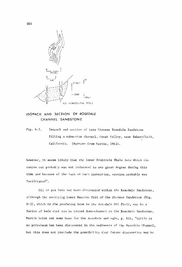
250
ISOPACH A N D S E C T I O N OF ROSEDALE
C H A N N E L S A N D S T O N E
Fig. 6-7. Isopach and s e c t i o n of Late Miocene Rosedale Sandstone
f i l l i n g a submarine channe l , Great V a l l e y , nea r Bake r s f i e ld ,
C a l i f o r n i a . (Redrawn from Mar t in , 1963).
however, i t seems l i k e l y t h a t t h e lower F r u i t v a l e Shale i n t o which t h e
canyon c u t probably w a s n o t i ndura t ed t o any g r e a t degree du r ing t h i s
t i m e and because of t h e l a c k of much i n d u r a t i o n , e r o s i o n probably w a s
f a c i l i t a t e d " .
O i l o r gas have n o t been d i scove red w i t h i n t h e Rosedale Sandstone,
a l though t h e ove r ly ing Lower Massive Uni t of t h e S tevens Sandstone (Fig.
6-3), which i s t h e producing zone i n t h e Rosedale O i l F i e l d , may be a
f a c i e s of beds t h a t can be t r a c e d down-channel t o t h e Rosedale Sandstone.
Mar t in ho lds o u t some hope f o r t h e Rosedale and s a y s , p. 4 5 5 , " L i t t l e o r
no pe t ro leum h a s been d i scove red i n t h e sed iments of t h e Rosedale Channel,
bu t t h i s does n o t p rec lude t h e p o s s i b i l i t y t h a t f u t u r e d i s c o v e r i e s may be

251
made. F i l l e d and b u r i e d submarine canyons should have an e x c e l l e n t
p o t e n t i a l f o r any exp lo ra to ry e f f o r t s a l though from t h e n a t u r e of t h e
sands tone b o d i e s , l o c a t i o n and r e c o g n i t i o n may b e d i f f i c u l t " .
O i l and G a s F i e l d s
Sediments i n a n c i e n t submarine v a l l e y s have n o t o f t e n been
s t r a t i g r a p h i c t a r g e t s f o r o i l and gas e x p l o r a t i o n , a l though such f e a t u r e s
are p r e s e n t on a l l c o n t i n e n t a l margins and appear t o have been s o i n t h e
p a s t . The d i f f i c u l t i e s t h a t arise i n s e a r c h i n g f o r a s t r a t i g r a p h i c t r a p
i n a b u r i e d submarine v a l l e y have h i t h e r t o prec luded much en thus iasm f o r
such an e x p l o r a t i o n programme. With few excep t ions , such as t h e pre-
v i o u s l y mentioned e x p l o r a t o r y h o l e d r i l l e d i n t o t h e Yoakum Channel i n
Texas, e x p l o r a t i o n i n submarine v a l l e y and f a n d e p o s i t s has been r e s t r i c t e d
t o areas such as t h e Ventura O i l F i e l d of C a l i f o r n i a , where f o l d i n g of t h e
beds a f f o r d s s t r u c t u r a l c l o s u r e . And y e t , as po in ted o u t by Hedberg (1970,
p . 3 ) , "For t h e pe t ro leum g e o l o g i s t , it is s i g n i f i c a n t t h a t through t h e
ages t h e c o n t i n e n t a l margin has been t h e g r e a t mixing bowl i'n which has
been brewed most o f t h e w o r l d ' s pe t ro leum and from which most of i t s
pe t ro leum p roduc t ion t o d a t e h a s been der ived" .
d e p o s i t i o n a l environment and pe t ro leum p o t e n t i a l of submarine f a n s on a
c o n t i n e n t a l rise, Emery e t al. (1970, p . 103) say , "The l a r g e mass
movements t h a t remove t h i c k sequences o f sed iments from t h e c o n t i n e n t a l
s l o p e b r i n g them t o t h e upper p a r t of t h e c o n t i n e n t a l r ise. Because
t h e s e d i s p l a c e d sed iments are f i n e g r a i n e d , when depos i t ed en masse they
can r e t a i n most of t h e i r o rgan ic matter o u t of r each of t h e ove r ly ing
oxygen-rich water. Continuous se i smic r e f l e c t i o n p r o f i l e s and co res
sugges t t h a t sandy t u r b i d i t e s a l s o are p resen t th roughout most of t h e
c o n t i n e n t a l r i se , and some of them are in te rbedded w i t h t h e d i sp laced
s i l t s and c l a y s from t h e c o n t i n e n t a l s lope . Under such c o n d i t i o n s , w e
might expec t t h e d i s p l a c e d s i l t s and c l a y s t o s e r v e as o i l sou rce beds and
Commenting on t h e
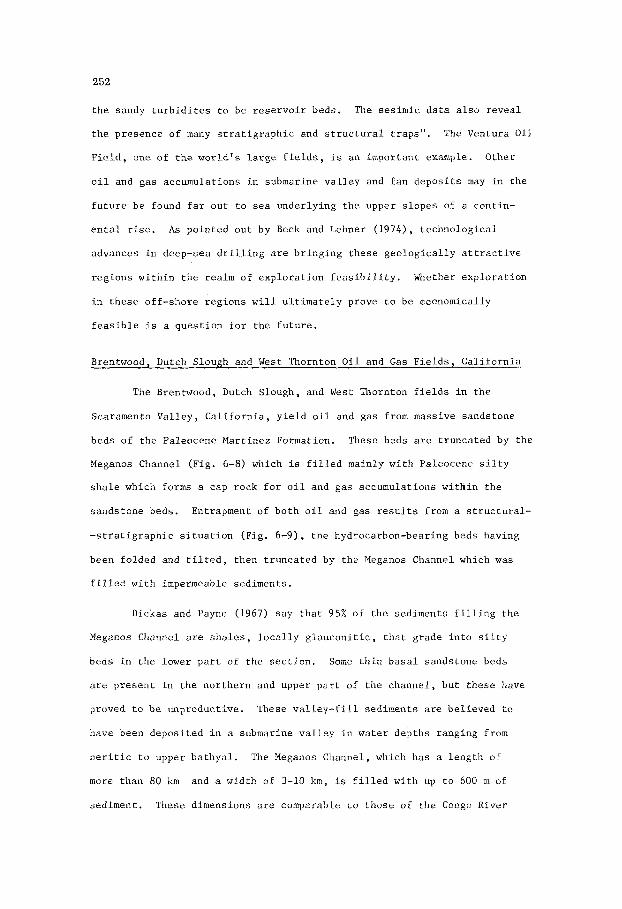
252
t h e sandy t u r b i d i t e s t o be r e s e r v o i r beds. The sesimic d a t a a l s o r e v e a l
t h e presence of many s t r a t i g r a p h i c and s t r u c t u r a l t r aps" .
F i e l d , one of the wor ld ' s l a r g e f i e l d s , is an impor tan t example. Other
o i l and gas accumula t ions i n submarine v a l l e y and f a n d e p o s i t s may i n t h e
f u t u r e b e found f a r o u t t o sea under ly ing t h e upper s l o p e s of a cont in-
e n t a l r ise. A s po in ted o u t by Beck and Lehner (1974), t e c h n o l o g i c a l
advances i n deep-sea d r i l l i n g a r e b r i n g i n g t h e s e g e o l o g i c a l l y a t t r a c t i v e
r eg ions w i t h i n t h e realm of e x p l o r a t i o n f e a s i b i l i t y .
i n t h e s e o f f - sho re r eg ions w i l l u l t i m a t e l y prove t o be economically
f e a s i b l e is a q u e s t i o n f o r t h e f u t u r e .
The Ventura O i l
Whether e x p l o r a t i o n
Brentwood, Dutch Slough and West Thornton O i l and G a s F i e l d s , C a l i f o r n i a
The Brentwood, Dutch Slough, and West Thornton f i e l d s i n t h e
Scaramento Va l l ey , C a l i f o r n i a , y i e l d o i l and gas from massive sands tone
beds o f t h e Paleocene Mar t inez Formation. These beds are t runca ted by t h e
Meganos Channel (Fig. 6-8) which i s f i l l e d mainly wi th Paleocene s i l t y
s h a l e which forms a cap rock f o r o i l and gas accumula t ions w i t h i n t h e
sands tone beds . Entrapment of b o t h o i l and gas r e s u l t s from a s t r u c t u r a l -
- s t r a t i g r a p h i c s i t u a t i o n (F ig . 6-9), t h e hydrocarbon-bearing beds having
been fo lded and t i l t e d , then t r u n c a t e d by t h e Meganos Channel which w a s
f i l l e d wi th impermeable sed iments .
Dickas and Payne (1967) say t h a t 95% of t h e sediments f i l l i n g t h e
Meganos Channel are s h a l e s , l o c a l l y g l a u c o n i t i c , t h a t g rade i n t o s i l t y
beds i n t h e lower p a r t of t h e s e c t i o n . Some t h i n b a s a l sands tone beds
are p r e s e n t i n t h e n o r t h e r n and upper p a r t o f t h e channel , bu t t hese have
proved t o b e unproduct ive .
have been depos i t ed i n a submarine v a l l e y i n water dep ths ranging from
n e r i t i c t o upper b a t h y a l . The Meganos Channel, which h a s a l eng th of
more than 80 km and a wid th of 3-10 km, is f i l l e d wi th up t o 600 m of
sediment. These dimensions a r e comparable t o those o f t h e Congo River
These v a l l e y - f i l l sed iments are be l i eved t o

253
ISOPACH OF MEGANOS CHANNEL. CALIFORNIA
F i g . 6-8. I sopach of t h e P a l e o c e n e Meganos Channel, Sacramento V a l l e y ,
C a l i f o r n i a . T h i s c h a n n e l e r o d e s Pa leocene s a n d s t o n e beds and
i s f i l l e d main ly w i t h s h a l e and s i l t s t o n e deposii ted as mud i n
water d e p t h s r a n g i n g from n e r i t i c t o upper b a t h y a l . (Redrawn
from Dickas and Payne, 1967).
submar ine canyon which a c c o r d i n g t o Heezen e t a l . (1964) h a s a l e n g t h
o f 320 km, a w i d t h of up t o 8 k m , and a d e p t h of up t o 900 m below t h e
canyon r i m . Shepard and Emery (1973 a ) f u r t h e r d e s c r i b e t h e Congo River
canyon as V-shaped and r a n g i n g i n d e p t h up t o 1,400 m from t h e r i m t o t h e
b a s e .
Although t h e Brentwood, Dutch Slough, and West Thornton f i e l d s
are no t producing from s e d i m e n t s w i t h i n t h e submarine v a l l e y , t h e i r
l o c a t i o n s depend on t h e j u x t a p o s i t i o n of f o l d e d and upturned hydrocarbon-
- b e a r i n g s a n d s t o n e s w i t h impermeable s h a l y b e d s i n t h e Meganos Channel.
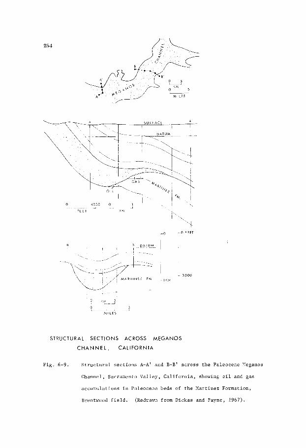
254
- O I O F E E T
L! B D A T U M I ' I
I -
-
M A R l I N € Z FM
I 1, KM
1 3 0 0 0
STRUCTURAL SECTIONS ACROSS MEGANOS
C H A N N E L , CALIFORNIA
Fig . 6-9. S t r u c t u r a l s e c t i o n s A-A' and €3-B' a c r o s s t h e Paleocene hleganos
Channel, Sacramento Va l l ey , C a l i f o r n i a , showing o i l and gas
accumulations i n Paleocene beds of t h e Martinez Formation,
Brentwood f i e l d . (Redrawn from Dickas and Payne, 1967).

255
S t r a t i g r a p h i c and s t r u c t u r a l c o n t r o l i s s i m i l a r t o t h a t of t h e Mar l in
F i e l d (F ig . 6-11) i n the Gippsland Bas in , V i c t o r i a . The Brentwood and
Dutch Slough, cons idered t o b e major f i e l d s , a r e l o c a t e d i n t h e south-
-western p a r t of t h e channel shown i n F ig . 6-8, whereas t h e West Thornton
f i e l d l i e s i n t h e n o r t h e r n p a r t . Ul t imate p roduc ib le r e s e r v e s of gas i n
t h e Dutch Slough f i e l d a r e e s t ima ted t o amount t o more than 300,000 m i l l i o n
cub ic f e e t (8,400 m i l l i o n cub ic metres).
Mar l in Gas F i e l d , V i c t o r i a
I n t h e Mar l in F i e l d (F igs . 6-10 and 6-11) o f t h e Gippsland Basin,
V i c t o r i a , gas and some l i g h t o i l are produced from f i v e sands tone u n i t s
w i t h i n t h e Paleocene t o Eocene Lat robe Group. These u n i t s are t i l t e d ,
t r u n c a t e d by an e r o s i o n a l s u r f a c e , and f l anked on t h e east by a submarine
channel f i l l e d wi th mudstones of t h e Oligocene t o Miocene Lakes Entrance
Formation. The mudstones provide an e f f e c t i v e s e a l . The gas-bear ing
sands tones l i e w i t h i n a s e c t i o n approximate ly 180 m t h i c k .
sands tone beds have a th i ckness of up t o 30 m , and t h e cumulative net-pay
th i ckness f o r a l l f i v e u n i t s exceeds 100 m. The sands tones a r e l i g h t grey ,
f r i a b l e , qua r t zose t o l i t h i c , g e n e r a l l y f ine -g ra ined , micaceous, and
l o c a l l y s i l t y wi th carbonaceous f l a k e s . P o r o s i t y and pe rmeab i l i t y have
ranges of 15-30% and up t o 1,000 m i l l i d a r c y s r e s p e c t i v e l y . The f i v e
sands tone u n i t s a r e sepa ra t ed by carbonaceous mudstones inc lud ing beds of
c o a l .
I n d i v i d u a l i
These gas-bear ing sands tones were depos i t ed i n a p a r a l i c t o
a l l u v i a l environment, b u t d e t a i l e d informat ion concerning t h e i r paleo-
geomorphic o r i g i n s have n o t been publ i shed . G r i f f i t h and Hodgson (1971)
are of t h e op in ion t h a t they a r e b ra ided s t r eam d e p o s i t s . The Lat robe
Group comprises a wedge of sed iments , t h i ckccn ing t o many thousands of
f e e t o f f s h o r e , t h a t formed a s a d e l t a i c complex. Coal beds i n t h e Mar l in
F i e l d a r e a , 50 km o f f s h o r e , are i n d i v i d u a l l y up t o 6 m t h i c k , bu t onshore
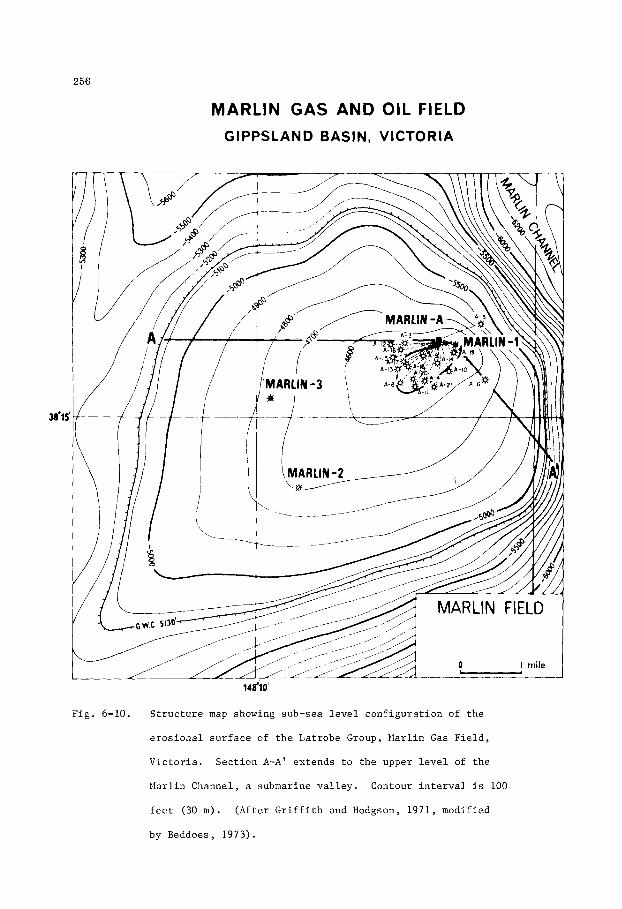
256
MARLIN GAS AND OIL FIELD GIPPSLAND BASIN, VICTORIA
Fig . 6-10. S t r u c t u r e map showing sub-sea l e v e l c o n f i g u r a t i o n of t h e
e r o s i o n a l s u r f a c e of t h e Lat robe Group, Mar l in Gas F i e l d ,
V i c t o r i a . S e c t i o n A-A' ex tends t o t h e upper l e v e l of t h e
Mar l in Channel, a submarine v a l l e y . Contour i n t e r v a l i s 100
f e e t (30 m ) . (Af t e r G r i f f i t h and Hodgson, 1971, modified
by Beddoes, 1973).

25 7
MARLIN GAS A N D OIL FIELD STUCTURE CROSS-SECTION A-A'
A
SCALE
I L D M L T R L S
1 c n*,
Vertical Exaggeration 10 1
Fig . 6-11. S t r u c t u r e s e c t i o n A-A' a c r o s s t h e Mar l in Gas F i e l d , V i c t o r i a ,
showing a f a u l t bounding t h e wes te rn f l a n k of t h e Mar l in
Channel shown i n F ig . 6-10. (Af t e r G r i f f i t h and Hodgson, 1971,
modi f ied by Beddoes, 1973)
they range up t o 90 m t h i c k . In t h e o f f s h o r e a r e a s s t r a t i g r a p h i c zonat ion
w i t h i n t h e Lat robe Group depends on t h e assemblage of p o l l e n s and spores .
During t h e l a t e h i s t o r y of t h e Lat robe Group a marine t r a n s g r e s s i o n , which
began i n t h e Late Eocene, r e s u l t e d i n t h e d e p o s i t i o n e l sewhere of up t o
300 m of marine mudstone and up t o 30 m of g l a u c o n i t i c , ve ry f ine-gra ined
sands tone .
w e r e depos i t ed du r ing t h e i n i t i a l s t a g e s of a r e g i o n a l marine t r ansg res s ion
t h a t l a t e r l a i d down t h e Lakes Gnt racce Group.
These beds a r e inc luded i n t h e Lat robe Group, a l though they
The f i e l d , which has a s t r o n g wa te r d r i v e , i s a s t r u c t u r a l -
s t r a t i g r a p h i c t r a p . A southwest-plunging f o l d w a s eroded du r ing t h e Late
258
Eocene t o form a c losed e r o s i o n a l f e a t a e (a dome-shaped h i l l ) f l anked on
t h e east by a v a l l e y ( subsequent ly a submarine channe l ) .
c l o s u r e is approximate ly 275 m. The e s t ima ted u l t i m a t e p roduc ib le r e s e r v e s
of gas amount t o 3,500,000 m i l l i o n cub ic f e e t (98,000 m i l l i o n cub ic met res )
c o n t a i n i n g 175 m i l l i o n b a r r e l s ( 2 7 . 8 m i l l i o n cub ic met res ) of condensa te .
E s t i m a t e s of u l t i m a t e recovery of t h e l i g h t o i l have n o t been publ i shed .
Of p a r t i c u l a r i n t e r e s t i s t h e f a c t t h a t t h e f i l l i n g o f t h e Mar l in submarine
channel w i th muds h a s been a prime f a c t o r i n forming an up-dip seal f o r gas
in t h e t i l t e d and eroded sands tone beds of t h e Lat robe Group. The s t r u c t -
t u r a l - s t r a t i g r a p h i c s i t u a t i o n i s similar t o t h a t of t h e Brentwood F i e l d
(F ig . 6-9) i n C a l i f o r n i a .
Maximum v e r t i c a l
Ventura O i l and Gas F i e l d , C a l i f d r n i a .
Product ion i n t h e Ventura O i l F i e l d of t h e Ventura Basin,
C a l i f o r n i a , is ob ta ined from t h e Upper P l iocene P ic0 Sandstone and t h e
Lower P l iocene Repet to Sandstone. Both u n i t s form a cont inuous sequence,
more than 3,000 m t h i c k , of o i l -beaz ing sands tones , sandy s i l t d t o n e s and
o rgan ic - r i ch s i l t y c l ays tones . The sequence comprises t u r b i d i t y c u r r e n t
d e p o s i t s and normal deep-sea sed iments t h a t formed a submarine f a n i n a
t e c t o n i c a l l y a c t i v e b a s i n (Natland and Kuenen, 1951). Coincidence of t h e
a r e a of optimum sand d e p o s i t i o n and t h e a r e a of growth of t h e Ventura
a n t i c l i n e has r e s u l t e d i n a t h i c k o i l -bea r ing s e c t i o n . Th i s s e c t i o n has
been d iv ided i n t o s e v e r a l o i l -producing zones a t depths ranging from 300
t o 2 ,700 m . The upper most zone y i e l d s gas and condensa te (56' A .P . I . ) ,
t h e upper zones y i e l d l i g h t o i l ( 4 2 O A.P . I . ) , and t h e lower zones y i e l d
h e a v i e r o i l (300 A.P . I . ) . These accumula t ions , which occur i n a number
of i n d i v i d u a l t r a p s i n s e p a r a t e f a u l t b locks w i t h i n a r e v e r s e and t h r u s t -
f a u l t e d a n t i c l i n e , have d i f f e r e n t r e s e r v o i r p r e s s u r e s and o i l cha rac t e r -
i s t i c s (Levorsen, 1967). Other accumula t ions having a similar d e p o s i t i o n a l
and s t r u c t u r a l genes i s a r e p r e s e n t i n the Lower P l iocene of t h e Los Angeles

259
Basin , and i n t h e Upper Miocene o f t h e San Joaquin Bas in , bo th i n C a l i f -
o r n i a .
Within t h e 2,700 metres of o i l - b e a r i n g s e c t i o n i n t h e Ventura
F i e l d , pe rmeab i l i t y of t h e sands tones d e c r e a s e s p r o g r e s s i v e l y wi th dep th
from a range of 60-250 m i l l i d a r c y s i n t h e upper zone t o less t h a t 5 m i l l i -
d a rcys i n t h e lower. The o i l - b e a r i n g sands tones i n t h e lowermost zone
commonly have a pe rmeab i l i t y of on ly one m i l l i d a r c y , sugges t ing t h a t t h e
p e r m e a b i l i t y of t h i s u n i t has been reduced by a f a c t o r of s e v e r a l hundred
times s i n c e i t was depos i t ed . This d r a s t i c r e d u c t i o n h a s r e s u l t e d d i r e c t l y
from t h e s h a t t e r i n g and compaction of g r a i n s by a combination of s t a t i c
and dynamic p r e s s u r e s caused by depth of b u r i a l and t h e s t r e s s e s t h a t
produced f o l d i n g and f a u l t i n g , and i n d i r e c t l y by t h e p lugging of pore
space r e s u l t i n g from d i a g e n e t i c a l t e r a t i o n s . There is no ev idence (Natland
and Kuenen, 1951) t h a t s ed imen to log ica l d i f f e r e n c e s i n t h e upper and lower
p a r t s o f t h e s e c t i o n account i n any way f o r t h e v a r i a t i o n s i n pe rmeab i l i t y .
The Ventura F i e l d area was t h e s i t e of d e p o s i t i o n by t u r b i d i t y c u r r e n t s
du r ing most of t h e P l iocene , and t h i s f a c i e s c h a r a c t e r i z e s t h e e n t i r e
o i l - b e a r i n g s e c t i o n .
Hertel (1929) e s t ima ted t h a t u l t i m a t e recovery from t h e Ventura
F i e l d would amount t o more than 250 m i l l i o n b a r r e l s of o i l and 600,000
m i l l i o n cubic f e e t of gas . S ince then: a d d i t i o n a l producing zones w i t h i n
t h e f i e l d have been d iscovered . Halbouty (1978) states t h a t a t t h e
beginning of 1967 t h e cumula t ive p roduc t ion p l u s t h e e s t ima ted r ecove rab le
r e s e r v e s of o i l i n t h e Ventura f i e l d amounted t o approximate ly 818 m i l l i o n
b a r r e l s (130 m i l l i o n cubic m e t r e s ) . He a l s o states t h a t a t t h e beginning
of 1966 t h e cumula t ive product ion of gas was 1,847,000 m i l l i o n cubic f e e t
(52,000 m i l l i o n cub ic me t re s ) . It i s of i n t e r e s t t o n o t e t h a t more r e c e n t
estimates of u l t i m a t e p roduc t ion i n t h i s f i e l d , d i scovered i n 1916, have proved
t o be about t h r e e t i m e s g r e a t e r t han t h e e a r l i e r estimates.

This Page Intentionally Left Blank

261
Chapter 7
TIDAL CURRENT SAND BODIES
I n t r o d u c t i o n
Geomorphology
T i d a l c u r r e n t r i d g e s of sand and s i l t are known i n many p a r t s of
t h e world. They are developed as ribbon-shaped sand bod ies a l igned
p a r a l l e l t o t h e t i d a l c u r r e n t d i r e c t i o n . These sand bod ies are commonly
found a t dep ths w i t h i n t h e range 10-100 m , on p a r t s of t h e c o n t i n e n t a l
s h e l f s u b j e c t t o s t r o n g t i d a l c u r r e n t s f lowing a t v e l o c i t i e s of up t o
5 km/hr. Of those d e s c r i b e d , examples i n t h e North Sea ( P e t t i j o h n ,
P o t t e r , and S i e v e r , 1972; B l a t t , Middle ton , and Murray, 1972; Houbolt , 1968;
and S t r i d e , 1963) , i n t h e Gulf of Korea (Off, 1963), and i n Taiwan S t r a i t
(Boggs, 1974) are mentioned h e r e . The dimensions of t h e s e r i d g e s are
remarkably similar. I n t h e North Sea (F igs . 7-1 and 7-2) t hey have a
t h i c k n e s s o f up t o 50 m, a l e n g t h of up t o 70 km bu t commonly less than
50 km, and a wid th of 3-5 km. I n t h e Gulf of Korea (Fig. 7-3) t hey have
a t h i c k n e s s o f 10-35 m, a l e n g t h of 10-60 km, and a wid th of 2-3 km. In
Taiwan S t r a i t they are 5-30 m t h i c k , and up t o 3.5 km wide. Swif t and
HcMullen (1968) a l s o d e s c r i b e t i d a l sand bqd ies i n t h e Bay of Fundy, Nova
S c o t i a . These bod ies a r e up t o 30 m t h i c k and 30 km long .
In t h e North Sea t i d a l r i d g e s were e x t e n s i v e l y s t u d i e d by Houbolt
(1968).
a c r o s s t h e i r s t r i k e , are l a r g e c u r r e n t r i p p l e s r e f e r r e d t o as t i d a l sand
waves. Although ve ry l i t t l e i s known about t h e i n t e r n a l s t r u c t u r e of t i d a l
c u r r e n t r i d g e s , the movement of sand waves a c r o s s t h e i r s u r f a c e s is r e f l e c t e d
i n t e r n a l l y as cross-bedding. The n a t u r e of t h i s cross-bedding is n o t w e l l
known, b u t i s i n d i c a t e d by spa rke r surveys t o be p l a n a r and sweeping.
On t h e s u r f a c e of t h e s e asymmetrical r i d g e s , and t r e n d i n g ob l ique ly

262
Gentle back slope with megoripples
Steep slope with
F i g . 7-1. O u t l i n e s and g e n e r a l i z e d c r o s s - s e c t i o n of s a n d r i d g e s i n t h e
s o u t h e r n b i g h t of t h e North Sea .
P o t t e r and S i e v e r , 1972, a f t e r Houbol t , 1968).
(Redrawn by P e t t i j o h n ,
These Nor th Sea sand r i d g e s , formed on t h e f l a t s e a f l o o r of an open s h e l f ,
a p p e a r t o have f l a t b a s e s and convex t o p s . T h i s i n t e r p r e t a t i o n i s i n d i c a t e d
by s p a r k e r s u r v e y s which o u t l i n e t h e geometry of t h e r i d g e s , and i s f u r t h e r
s u g g e s t e d by t h e f a c t t h a t t h e sand b o d i e s m i g r a t e a c r o s s t h e sea f l o o r
l i k e g i a n t r i p p l e s .
-day r i v e r b u t from t h e sea f l o o r i t s e l f , i s e x t r e m e l y w e l l s o r t e d and f i n e -
-gra ined .
The sand which is n o t d i r e c t l y d e r i v e d from any p r e s e n t -
Cor ing does n o t show any g r a i n g r a d a t i o n w i t h i n t h e r i d g e s .

263
Well Bank sea level ____ -
~ --<k-l
Smith Knoll seo level
Vorfolk , , , ,L , , , YL L u i A ' " ' ' , . L A
35' 40' 45' 50' 55' 2" 5' 10' 15' 20' 25' 30' 35'
35'
30 '
25'
20 '
15'
10'
5'
53"
55'
50'
45'
F ig . 7-2. Isopach map of sand r i d g e s formed by t i d a l c u r r e n t s i n t h e
sou the rn b i g h t of t h e North Sea.
Middleton, and Murray, 1972, a f t e r Houbolt , 1968).
(Modified by B l a t t ,

264
TIDAL CURRENT D I R E C T I O N -.I
Q
TI DAL CURRENT RIDGES
THE GULF OF KOREA
20 MILES
Fig . 7-3. T i d a l c u r r e n t r i d g e s of sand i n t h e Gulf of Korea. T i d a l
c u r r e n t d i r e c t i o n s i n d i c a t e d by a r rows . (Af t e r O f f , 1963,
redrawn from U.S. Navy Hydrographic O f f i c e c h a r t s . )
265
Measurements of grain orientation indicate a preferred direction at 45' to
the strike of the sand ridges, a result that is not surprising in view of
the oblique movement of current ripples across the leading edges of the
sand ridges. The non-parallelism of average grain orientation to the trend
of the sand ridges suggests that measurements of mean grain orientation in
sandstones should be applied to the interpretation of sandstone body trends
with some reservation.
Off (1963) describes tidal current ridges (Fig. 7-3) in the Gulf of
Korea.
where in places the water depths, at distances up to 65 km from shore, do
not exceed 40 m. The ridges form an arcuate pattern trending parallel to
the direction of flow of the tidal currents. Of particular interest is an
example showing the alignment of ridges both parallel and normal to the
coast line. Other examples illustrated by Off show the alignment of tidal
current ridges in straits and estuaries to be essentially parallel to the
coast. These geomorphologic relationships w i l l have some bearing on the
interpretation of ancient sand bodies such as off-shore bars and barrier
islands which also lie parallel to the coastline. Off (1963, p. 327)
describes the tidal current ridges in the Gulf of Korea as follows, "Here,
the ridges are spaced with an average of 3 miles between crests and rise
an average of 65 feet from their base. They are oriented approximately
parallel with the west coast of Korea and perpendicular to the north end
of the Yellow Sea".
These ridges have developed on a flat and shallow continental shelf
With reference to sand ridges in Taiwan Strait, Boggs (1974, p. 253)
says, "The rather widespread development of large, asymmetrical sand waves
in Taiwan Strait suggests active transport of bottom sediment. The pattern
of sediment transport, although not yet accurately determined, appears to
be complex; transport in a seaward direction, transport in a landward
direction, and longshore transport are all indicated in various parts of

266
t h e s t ra i t . The sand waves are developed i n areas o f sandy bottom sed i -
ments t h a t Niino and Emery (1961) cons idered t o be r e l i c t P l e i s t o c e n e
sed iments ; i t appears q u i t e l i k e l y , however, t h a t t h e sediment has been
e x t e n s i v e l y reworked s i n c e P l e i s t o c e n e t i m e by bottom c u r r e n t s t h a t may
have markedly a l t e r e d o r i g i n a l sed imentary s t r u c t u r e s and mine ra l concent-
r a t i o n s , as w e l l as l o c a l topography of t h e sea f loo r" .
E-log C h a r a c t e r i s t i c s
In t h e North Sea t h e sand i n t i d a l c u r r e n t r i d g e s i s commonly f i n e -
-gra ined and ex t remely w e l l s o r t e d , having been de r ived from o l d e r beds
d e p o s i t e d i n t h e sea o r on a s u r f a c e subsequent ly inundated by t h e sea.
Some r i d g e s c o n s i s t of muddy sand o r muddy s i l t . Sand r i d g e s , be ing
composed of re-worked sediment of f a i r l y uniform g r a i n s i z e , have a homo-
geneous t e x t u r e and show no s i g n i f i c a n t g r a i n g rada t ion . A s shown by
Houbolt (1968) some r i d g e s i n t e r n a l l y r e f l e c t shock waves from a s p a r k e r ,
i n d i c a t i n g cross-bedding o r i n c l i n e d bedding having minor v a r i a t i o n s of
t e x t u r e and composi t ion , whereas o t h e r r i d g e s g ive no r e f l e c t i o n s and
appear t o be i n t e r n a l l y homogeneous. In e i t h e r case i t can bi: expected
that t h e E-log s e l f - p o t e n t i a l curve of an a n c i e n t t i d a l c u r r e n t sand body
w i l l show n e i t h e r a tendency t o b e be l l - shaped nor funnel-shaped, bu t
e x h i b i t a b locky c h a r a c t e r i s t i c s i m i l a r t o t h a t of some d i s t r i b u t a r y channel
sand bod ies .
Compaction
A t some s t a g e i n t h e geo log ica l h i s t o r y o f t i d a l c u r r e n t sand r i d g e s ,
p rovided they remain below s e a l e v e l , t hey are b u r i e d i n a sed imentary p i l e .
Thus p re se rved i n t h e g e o l o g i c a l r eco rd , they are sub jec t ed by i n c r e a s i n g
dep th of b u r i a l t o t h e e f f e c t s of compaction.
ence of t h e sands tone body, and i n d rap ing of t h e ove r ly ing f i n e r sediments.
Subsidence may be minimal, depending on t h e degree of compaction and th ick-
These w i l l r e s u l t i n subs id-

267
n e s s of t h e under ly ing s e c t i o n of sed iments . In t h e case of t h e North Sea
t i d a l c u r r e n t sand r i d g e s , t h e s e c t i o n o f sediment r e s t i n g on conso l ida t ed
rock is compara t ive ly t h i n . The f l a t s ea - f loo r between t h e sand r i d g e s is
covered wi th a g r a v e l l y l a g d e p o s i t , composed of c h e r t pebbles and s k e l e t a l
f ragments , whi& m r l i e s a bed of s t i f f b lu ish-grey c l a y . S i m i l a r l y , where
t i d a l c u r r e n t sand r i d g e s are formed i n a marine t r a n s g r e s s i v e s i t u a t i o n ,
t h e compactional e f f e c t s r e s u l t i n g from subs idence of t h e sand body w i l l
n o t g r e a t l y a l t e r t h e o r i g i n a l shape of t h e body. Consequently, i t s topo-
g raph ic c o n f i g u r a t i o n w i l l be p re se rved , a l though somewhat modi f ied , i n t h e
s t ra ta i n which i t is b u r i e d . I n t e r p r e t a t i o n of t h e o r i g i n a l geometry of
such sands tone bod ies can b e s t b e done by means of s e c t i o n s and maps drawn
w i t h a datum benea th t h e body.
Ancient Sand Bodies
Many examples have been c i t e d of sands tone bod ies depos i t ed as sand
b a r s on sha l low marine s h e l v e s s u b j e c t t o t h e a c t i o n of waves and ocean
c u r r e n t s .
and s i l t , and some accumulated on a carbonate s h e l f . Others appear t o
t r a n s g r e s s b o t h ca rbona te and non-carbonate environments. S e l l e y (1967)
d e s c r i b e s a Miocene s e c t i o n i n Libya where f l u v i a l and p a r a l i c sands
depos i t ed i n a d e l t a i c environment can be t r a c e d i n t o l imes tone beds
depos i t ed on a sha l low marine ca rbona te s h e l f . Desc r ip t ions o f sands tone
bod ies are commonly incomple te , and t h e i n t e r p r e t a t i o n s p laced on t h e i r
o r i g i n s may be equ ivoca l . P e t t i j o h n , P o t t e r and S ieve r (1972, p. 493)
s a y , " In t h e absence of p l e n t i f u l , good d e s c r i p t i o n s of a n c i e n t marine
s h e l f sand b o d i e s , w e have a t tempted t o summarize and s y n t h e s i z e t h e i r
p r o p e r t i e s from few and s c a t t e r e d d a t a (Table 11-6). Much remains t o b e
learned" .
a n c i e n t marine s h e l f sands as fo l lows .
Some of t h e s e a n c i e n t sands w e r e swept on t o a se& f l o o r of c l a y
They f u r t h e r d e s c r i b e some o f t h e g e n e r a l c h a r a c t e r i s t i c s of

"The sand o f many a n c i e n t marine s h e l v e s t ends t o be m i n e r a l o g i c a l l y
mature , e s p e c i a l l y on c r a t o n s , presumably because i t h a s passed through t h e
s h o r e l i n e complex. Thus a r g i l l a c e o u s rock f ragments and u n s t a b l e mine ra l s
g e n e r a l l y are n o t ve ry abundant. G laucon i t e , d e t r i t a l ca rbona te s k e l e t a l
d e b r i s , marine f o s s i l s , and co l lophane are commonly p r e s e n t . A r e l i c t
fauna and anomalously coa r se g r a i n s are common i n t h e upper few f e e t of
some s h e l f sands . Grave l o r conglomerate may b e de r ived l o c a l l y . Cementing
a g e n t s are mostly chemica l , b u t may inc lude a p p r e c i a b l e d e t r i t a l material
proximal t o c l a y o r s h a l e t r a n s i t i o n s . S o r t i n g g e n e r a l l y is good t o e x c e l l e n t ,
and t h e r e i s perhaps a tendency f o r be t te r - than-average rounding. The
v a r i a b i l i t y of t e x t u r a l parameters between samples i s g e n e r a l l y very l o w " .
T i d a l c u r r e n t sand bod ies probably have f o s s i l c o u n t e r p a r t s , b u t
none have been proven. The E l a t e r i t e Bar i n t h e Lower Permian White R i m
Sandstone o f Utah (Baars and Seagar , 1970) h a s morphological s i m i l a r i t i e s .
So do some of t h e a r c u a t e sand bod ies of t h e Lower Cre taceous Viking
Formation i n A l b e r t a and Saskatchewan (Evans, 1970), a l though o t b e r Viking
sand bod ies are i n t e r p r e t e d as s h o r e l i n e and near -shore sands depos i t ed as
beaches and of f -shore b a r s . Off (1963) has sugges ted t h a t t i d a l c u r r e n t s
were e f f e c t i v e i n t h e d e p o s i t i o n of t h e Upper Miss i s s ipp ian P a l e s t i n e
Sands tone , which l i e s s t r a t i g r a p h i c a l l y above t h e channel-forming Bethe l
Sandstone (Fig. 1-29), and a l s o i n t h e d e p o s i t i o n of t h e Upper Cretaceous
Cardium Sandstone o f A lbe r t a . With r e f e r e n c e t o t h e P a l e s t i n e Sandstone
h e s a y s , p . 335, " In a r e c e n t s tudy o f t h e Ches te r sands of t h e I l l i n o i s
Basin ( P o t t e r e t az., 1958) , a t t e n t i o n w a s c a l l e d t o t h e alignment of
sand bod ies p a r a l l e l w i th t h e c u r r e n t d i r e c t i o n s i n d i c a t e d by cross-bedding,
and pe rpend icu la r t o r e g i o n a l s t r i k e . The r e l a t i v e p o s i t i o n s of some of
t h e s e sand bod ies ( a s shown by P o t t e r ' s F igure 13 f o r example) and t h e i r
unique d imens iona l s c a l e , bo th as t o i n d i v i d u a l t h i ckness and d i s t a n c e of
s e p a r a t i o n , combined wi th t h e presence of cross-bedding and sugges t ion of

269
a marine environment, s t r o n g l y suggest t h a t they are t i d a l c u r r e n t r i dges” .
The P a l e s t i n e is i n t e r p r e t e d by P o t t e r et aZ. (1958) as a channel sand-
s tone . The Cardium (Fig. 3-22) sand bodies are considered by Berven (1966)
and o t h e r s t o be o f f - sho re b a r s .
The E la t e r i t e Bar (Fig. 7-4 ) is composed of f ine -g ra ined , w e l l
s o r t e d , qua r t zose sandstone t h a t is f a i r l y uniformly s a t u r a t e d with heavy
a s p h a l t i c o i l t h a t seeps ou t as bitumen from t h i s exhumed s t r a t i g r a p h i c t r a p .
The sandstone body, which t r e n d s i n a s l i g h t arc, is up t o 60 m t h i c k , 2-3
km wide, and 16 km long. I n t e r n a l l y , t h e sandstone e x h i b i t s l a rge - sca l e
sets of sweeping c r o s s - s t r a t i f i c a t i o n t h a t d i p 20-25 degrees sou theas t
and have long t a n g e n t i a l b a s a l con tac t s .
The o r i g i n of t h e Ela te r i te Bar is n o t e n t i r e l y c l e a r . Several
i n v e s t i g a t o r s have agreed t h a t a l though t h e White R i m e Sandstone w a s i n
p a r t depos i t ed i n shal low w a t e r , i t w a s mainly e o l i a n . The ch ie f proponent
S E A W A R D
W L A G O O N A L
E
Fig. 7-4 . General ized c ros s - sec t ion of E la te r i te Bar i n t h e Lower
Permian White R i m Sandstone, sou theas t e rn Utah. (After
Baars and Seager , 1970).

270
of t h i s i n t e r p r e t a t i o n is Baker ( 1 9 4 6 ) . Baars and Seager (1970) have
r e f u t e d t h i s i n t e r p r e t a t i o n f o r t h e E la te r i te Bar which t h e y d e s c r i b e as a
d e f i n i t e and r e g u l a r sand bui ld-up conformably o v e r l y i n g t h e Organ Rock
S h a l e . They s a y , p . 716, "It i s p r o b a b l e t h a t t h e White R i m Sands tone i s
o f shallow-marine o r i g i n . The b e s t e v i d e n c e is t h e g e o m e t r i c and geo-
g r a p h i c c o n f i g u r a t i o n o f i t s c o n t a i n e d s a n d b a r s , t h e n a t u r e of t h e c r o s s -
- s t r a t i f i c a t i o n and r i p p l e marks , t h e r e g i o n a l r e l a t i o n s of t h e f o r m a t i o n ,
t h e p r e s e n c e of a p r o b l e m a t i c a l g a , and t h e absence of t r a c k s " .
Elateri te Bar i s conformably o v e r l a i n by Lower Permian s h a l y b e d s which i n
t u r n are unconformably o v e r l a i n by t h e T r i a s s i c Moenkopi Formation. No
e v i d e n c e h a s b e e n advanced t o s u g g e s t t h a t t h e E la t e r i t e Bar may b e ( o t h e r
t h a n t h e uppermost p a r t which h a s been re-worked) a n e r o s i o n a l f e a t u r e
formed by c u r r e n t s c o u r i n g . I n f a c t , Baars and Seager o f f e r e v i d e n c e t o
s u g g e s t t h a t t h i s i s n o t t h e case. With r e f e r e n c e t o t h e c o n f i g u r a t i o n of
t h e E la te r i te Bar t h e y s a y , p . 714, "The topography is of s e d i m e n t a r y
r a t h e r t h a n e r o s i o n a l o r i g i n , as shown by t h e g r a d u a l change of wavelength
of the r i p p l e s a l o n g c o n t i n u o u s bedding p l a n e s from 2 i n . a t t h e t o p t o
6 i n . a t t h e margin i n r e s p o n s e t o deepening of t h e water o v e r t h e edge of
t h e bar. From t h i s e v i d e n c e , i t i s a p p a r e n t t h a t t h e E l a t e r i t e Bar was
b u i l t where water d e p t h s r e a c h e d a t l e a s t 50 f t a l o n g i t s seaward margin".
F u r t h e r i n v e s t i g a t i o n s may c l a r i f y t h e s e d i f f e r e n c e s of i n t e r p r e t a t i o n and
d e t e r m i n e t h e o r i g i n of t h e E la te r i te Bar. E x t e r n a l l y and i n t e r n a l l y t h i s
s a n d s t o n e body h a s s imi la r i t i es o f d imens ions and a p p a r e n t d e p o s i t i o n a l
envi ronment t o t h o s e of t h e North Sea sand r i d g e s d e s c r i b e d by Houbolt
(1968) .
The
The p o t e n t i a l o f t i d a l c u r r e n t sand r i d g e s as r e s e r v o i r s f o r o i l
and g a s h a s been p o i n t e d o u t by Houbolt (1968, p . 2 6 4 ) w i t h r e f e r e n c e t o
mar ine t r a n s g r e s s i v e s i t u a t i o n s where l a r g e , t h i c k and e l o n g a t e d sand
b o d i e s c a n b e formed. He s a y s , "These sand b o d i e s w i l l c o n s i s t of c l e a n ,

271
wel l - so r t ed sand , w i thou t a v e r t i c a l g rada t ion i n g r a i n s i z e and w i l l be
o v e r l a i n by c layey marine sed iments i f t h e t r a n s g r e s s i o n con t inues .
Hence they w i l l form e x c e l l e n t r e s e r v o i r s f o r o i l " . To i l l u s t r a t e h i s
p o i n t h e c i t e s t h e Well Bank, one of t h e l a r g e t i d a l c u r r e n t r i d g e s i n
t h e North Sea. Assuming t h a t t h i s sand body has a p o r o s i t y of 30%, t h e
pore space be ing comple te ly f i l l e d wi th o i l , and t h a t 20% of t h e o i l can
b e r ecove red , he estimates t h a t t h e body could y i e l d 950 m i l l i o n b a r r e l s
(151 m i l l i o n cub ic meters ) of o i l . This i s a t h e o r e t i c a l c o n s i d e r a t i o n bu t
i l l u s t r a t e s t h e p o s s i b l e p o t e n t i a l of sands tone bod ies having s imilar
dimensions and good poros i ty -pe rmeab i l i t y c h a r a c t e r i s t i c s .

This Page Intentionally Left Blank

273
Chapter 8
ALLUVIAL FANS AND SHEETS
I n t r o d u c t i o n
Geomorphology
A l l u v i a l f a n s and s h e e t s are composed of g r a v e l , s and , and s i l t
de r ived as d e t r i t u s from t h e r a p i d e r o s i o n o f an u p l i f t e d c r u s t a l b e l t o r
b lock that i s commonly bounded by an a c t i v e f a u l t . The s u r f a c e expres s ion
of coa le sc ing f a n s and s h e e t s , f ed by v a l l e y s d i s s e c t i n g t h e u p l i f t e d
b lock (F ig . 8-1), is seen as a pediment o r a l l u v i a l p l a i n . In t h e sub-
s u r f a c e f a n s commonly merge t o form a wedge of sediment s e v e r a l thousand
f e e t t h i c k , whereas s h e e t s are ve ry much t h i n n e r and more widespread.
Where such f a n s are formed i n a semi-deser t environment, p a r t i c u l a r l y where
b lock f a u l t i n g movements of t h e e a r t h ' s c r u s t have formed a b a s i n and range
topography, g r e a t t h i c k n e s s e s of accumulated f a n s , commonly exceeding
3,000 m, b u t i n p l a c e s up t o 8,000 m (Crowel l , 1954) are known t o e x i s t .
B u l l (1972, p. 63) d e f i n e s a l l u v i a l f a n d e p o s i t s as fo l lows , "Fans c o n s i s t
of wa te r - l a id sed iments , debr i s - f low d e p o s i t s , o r bo th . Water-laid
sed iments occur as channel , s h e e t f l o o d , o r s e i v e d e p o s i t s . Entrenched
stream channels commonly are b a c k f i l l e d wi th g r a v e l t h a t may be imbr i ca t ed ,
mass ive , o r t h i c k bedded. Braided s h e e t s of f i ne r -g ra ined sed iments
depos i t ed downslope from t h e channel may be cross-bedded, massive, lamin-
a t e d , o r t h i c k bedded. Se ive d e p o s i t s a r e over lapping lobes of permeable
g rave l " . Leopold, Wolman, and Mil ler (1964) d e s c r i b e an a l l u v i a l f an
f l a n k i n g t h e Sandia Mountains, New Mexico. They say t h a t w i t h i n h a l f a
m i l e of t h e mountain f r o n t , which i s bonnded by a normal f a u l t , w e l l s
p e n e t r a t e d 10-30 m of sand and g r a v e l ove r ly ing g r a n i t e , whereas w e l l s
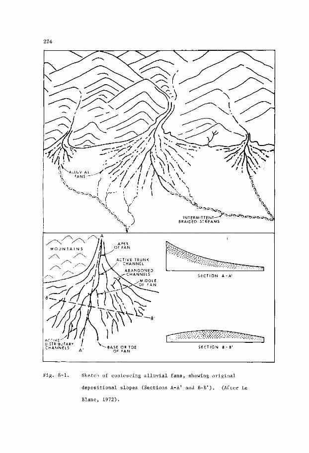
274
Fig . 8-1. Sketch of c o a l e s c i n g a l l u v i a l f a n s , showing o r i g i n a l
d e p o s i t i o n a l s l o p e s ( S e c t i o n s A-A' and B-B ' ) . ( A f t e r Le
Blanc , 1 9 7 2 ) .

215
d r i l l e d on ly a s h o r t d i s t a n c e f a r t h e r from t h e mountains p e n e t r a t e d more
than 100 m of sand and g r a v e l , i n d i c a t i n g a r a p i d th i ckenn ing of t h e
a l l u v i a l wedge. F a r t h e r from t h e sou rce , bo th f a n and s h e e t g r a v e l s and
sands become t r a n s i t i o n a l w i t h r i v e r and l a k e sands , s i l t s , and muds (F ig .
8-2), o r w i th marine sed iments where t h e pediment s l o p e s down t o t h e sea .
The middle t o lower s l o p e s of a l l u v i a l f a n s and s h e e t s are commonly
remarkable f o r t h e i r b ra ided s t r zam d e p o s i t s which c h a r a c t e r i z e d ra inage
p a t t e r n s h e a v i l y l aden wi th sediment. S e l l e y (1970, p . 24) s a y s , "Many
present -day b ra ided r i v e r s are found on piedmont f a n s a t t h e edge of
mountains where t h e r e are l a r g e amounts of sediment and d i scha rge is o f t e n ,
b u t n o t a lways , s easona l . Examples have been desc r ibed from t h e h o t
d e s e r t s of t h e mid w e s t of U . S . A . and from t h e p e r i g l a c i a l mountains of
FEET
0 5
0 5
- MILES -
K M
Fig . 8-2. Sec t ion of an a l l u v i a l f a n (1) grading i n t o r i v e r d e p o s i t s
(2) and ove r ly ing P l e i s t o c e n e l a k e c l a y s ( 3 ) i n a v a l l e y
f l a n k i n g t h e Sierra Nevada mountains of C a l i f o r n i a .
from B u l l , 1972 a f t e r Magleby and Kle in , 1965).
(Redrawn
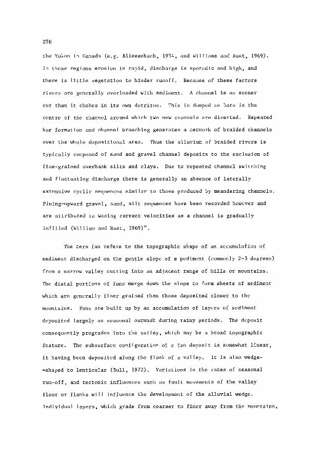
276
t h e Yukon i n Canada (e.g. Bl issenbach, 1954, and Williams and Rust, 1969).
I n these regions e ros ion i s r a p i d , d i scha rge is sporadic and h igh , and
t h e r e i s l i t t l e vege ta t ion t o h inde r runoff . Because of t h e s e f a c t o r s
r i v e r s a r e gene ra l ly overloaded with sediment. A channel is no sooner
c u t than i t chokes i n i t s own d e t r i t u s . This i s dumped a s ba r s i n t h e
c e n t r e of t he channel around which two new channels a r e d ive r t ed . Repeated
b a r formation and channel branching gene ra t e s a network of braided channels
over t h e whole d e p o s i t i o n a l a r e a . Thus t h e alluvium of braided r i v e r s i s
t y p i c a l l y composed of sand and g rave l channel depos i t s t o t h e exclusion of
f ine-grained overbank s i l ts and c l ays .
and f l u c t u a t i n g discharge t h e r e i s gene ra l ly an absence of l a t e r a l l y
ex tens ive c y c l i c sequences s i m i l a r t o those produced by meandering channels.
Fining-upward g r a v e l , sand, s i l t sequences have been recorded however and
a r e a t t r i b u t e d t o waning cu r ren t v e l o c i t i e s a s a channel is gradual ly
i n f i l l e d ( W i l l i a m and Rust , 1969)".
Due t o repeated channel switching
The term fan r e f e r s t o t h e topographic shape of an accumulakion of
sediment discharged on t h e g e n t l e s lope of a pediment (commonly 2-3 degrees)
from a narrow v a l l e y c u t t i n g i n t o an adjacent range of h i l l s o r mountains.
The d i s t a l p o r t i o n s of f ans merge down t h e s lope t o form s h e e t s of sediment
which a r e gene ra l ly f i n e r grained than those deposi ted c l o s e r t o t h e
mountains. Fans a r e b u i l t up by an accumulation of l a y e r s of sediment
deposi ted l a r g e l y a s s easona l outwash during r a iny per iods. The depos i t
consequently progrades i n t o t h e v a l l e y , which may be a broad topographic
f e a t u r e .
i t having been deposi ted along t h e f l ank of a va l l ey . It is a l s o wedge-
-shaped t o l e n t i c u l a r (Bu l l , 1972) . Var i a t ions i n t h e r a t e s of seasonal
run-off , and t e c t o n i c in f luences such a s f a u l t movements of t h e v a l l e y
f l o o r o r f l a n k s w i l l i n f luence t h e development of t he a l l u v i a l wedge.
Ind iv idua l l a y e r s , which grade from coa r se r t o f i n e r away from the mountains,
The subsurface conf igu ra t ion of a fan depos i t is somewhat l i n e a r ,

271
and which may a l s o show g r a i n gradat ion from coa r se r below t o f i n e r above,
w i l l no t have any r e g u l a r sequence with r e spec t t o one another . Layers of
coa r se g rave l may o v e r l i e l a y e r s of sand and g r i t , and the l a y e r s them-
s e l v e s may thicken and t h i n t o such an e x t e n t t h a t they a r e ind i s t ingu i shab le
as s t r a t i g r a p h i c u n i t s . Whether o r not such l a y e r s can be t r aced l a t e r a l l y
depends l a r g e l y on t h e l i n e of s e c t i o n taken, and on t h e geometry of t h e
a l l u v i a l fan body. A s pointed out by Bull (1972), i n d i v i d u a l beds may be
t r aced f o r long d i s t a n c e s a long r a d i a l s e c t i o n s , bu t along cross-fan
s e c t i o n s t h e beds appear t o be l e n t i c u l a r and a r e commonly cu t by channels.
These channels a r e most common nea r t h e apex of t h e a l l u v i a l fan body,
whereas i n t h e d i s t a l p a r t s , away from t h e source of t h e sediment, t h e
l a y e r s a r e more shee t - l i ke . The t o t a l s e c t i o n of sediment i n an a l l u v i a l
f an body may appear i n the subsurface, and poss ib ly a l s o i n outcrop, a s a
s i n g l e u n i t comprising poorly s o r t e d , unsequent ia l l a y e r s and l enses of
g r a v e l , sand, and s i l t .
E-log C h a r a c t e r i s t i c s
A l l u v i a l f a n d e p o s i t s c o n s i s t l a r g e l y of poorly s o r t e d c l a s t i c s
deposi ted by drainage systems t h a t commonly form braided s t reams, bu t
which may a l s o discharge t h e i r sediment loads during i n t e r m i t t e n t per iods
of s h e e t run-off. Consequently, t hese sediments accumulate r ap id ly t o
form t h i c k s e c t i o n s of superimposed l a y e r s and l e n s e s , each of which may
have no g r a i n g rada t ion o r may show some degree of gradat ion from coa r se r
below t o f i n e r above. Where p r e s e n t , i n an ind iv idua l l a y e r o r l e n s , g ra in
g rada t ion may be r e f l e c t e d i n the cha rac t e r of t h e s e l f - p o t e n t i a l curve,
i nd ica t ed by a poorly def ined bell-shape.
o r i n t e r c a l a t e d with po r t ions of t h e s e l f - p o t e n t i a l curve t h a t show no
meaningful c h a r a c t e r , t h e ove r -a l l con f igu ra t ion of t h e E-log may i n d i c a t e
merely a t h i c k s e c t i o n of poorly def ined l a y e r s . In t h i s r e s p e c t , where
t h e s e c t i o n i s s e v e r a l hundred f e e t t h i c k , t h e r e may be s i m i l a r i t i e s
Superimposed one on t h e o t h e r ,

278
between t h e E-logs of a l l u v i a l fan and t u r b i d i t y cu r ren t depos i t s . In
gene ra l , t h e E-log s e l f - p o t e n t i a l of an a l l u v i a l f an depos i t tends t o be
blocky and s e r r a t e d .
Compaction
Wedges of c l a s t i c sediments accumulating along a s ink ing trough
unde r l a in by a graben complex, o r p i l i n g up along t h e f l ank of an upthrust-
i n g range of mountains, a r e r e l a t i v e l y uncompactible and s o r e t a i n t o a
l a r g e degree t h e i r o r i g i n a l shape a f t e r b u r i a l . E s s e n t i a l l y , a l l u v i a l f an
d e p o s i t s a r e f l a t on t h e top and markedly bu t i r r e g u l a r l y concave a t the
base. The d e p o s i t s a r e always f lanked on one s i d e by o l d e r rock which is
probably i n l a r g e p a r t t h e source m a t e r i a l f o r t h e depos i t , and may a l s o
be unde r l a in by a l l u v i a l and l a c u s t r i n e sediments. In some a reas where the
u p l i f t e d b e l t of mountains i s f lanked by a marine c o a s t l i n e , o r where the
b e l t f l anks a v a l l e y invaded by t h e s e a , t h e a l l u v i a l fan depos i t may
o v e r l i e and merge l a t e r a l l y i n t o marine carbonate o r non-carbonate
sediments.
i s deposi ted, subsequent compaction w i l l modify t h e shape of t h e f an which
neve r the l e s s r e t a i n i t s c h a r a c t e r i s t i c of being r egu la r a t t h e top and
i r r e g u l a r a t t h e base. The choice of a datum f o r cons t ruc t ing a c ros s
s e c t i o n consequently l i e s i n t h e sequence of beds immediately overlying
t h e a l l u v i a l f an depos i t .
Depending on t h e n a t u r e of t h e base on which an h l l u v i a l f an
The o r i g i n a l po ros i ty and permeabi l i ty of a l l u v i a l f an sediments i s
e x c e l l e n t , and s u r f a c e water permeates downward so r a p i d l y t h a t only t h e
lowermost beds a r e water-bearing.
f l ank ing the Sandia Mountains, New Mexico, Leopold, Wolman, and Mi l l e r
(1964) s t a t e t h a t i n bores d r i l l e d nea r t h e base of t h e mountain range
water i s usua l ly obtained from t h e t h i n edge of t h e a l l u v i a l f an depos i t ,
c o n s i s t i n g of g rave l l y i n g on t h e rock of which t h e range is composed.
With r e fe rence t o a l l u v i a l f a n depos i t s
In

279
bores d r i l l e d s l i g h t l y f a r t h e r from t h e r ange , where s e v e r a l hundred f e e t
of a l l u v i a l f a n sand and g r a v e l w e r e p e n e t r a t e d , t h e sed iments a r e dry .
Compaction, w i th i n c r e a s i n g p r e s s u r e and tempera ture , dec reases t h e
p e r m e a b i l i t y of t h e l i t h i c clastics which are much more r e a d i l y a l t e r e d
than qua r t zose sands . A l t e r a t i o n s are e f f e c t e d by mechanica l ly f r a c t u r i n g
t h e g r a i n s , p a r t i c u l a r l y those of rock f ragments , f e l d s p a r s , and t h e f e r r o -
magnesian mine ra l s , by d i a g e n e t i c a l t e r a t i o n of t h e mine ra l c o n s t i t u e n t s
t o form c l a y mine ra l s which p a r t i a l l y p l u g t h e pore space, and by cement-
a t i o n of t h e g r a i n s wi th c a l c i t e , i r o n oxide and o t h e r c o n s t i t u e n t s
depos i t ed by c i r c u l a t i n g wa te r . The e f f e c t on water movements w i t h i n
deeply b u r i e d a l l u v i a l f a n d e p o s i t s i s t o dec rease t h e v e r t i c a l pe rmeab i l i t y
and t o deve lop t r e n d s of r e l a t i v e l y g r e a t e r pe rmeab i l i t y a long d e p o s i t i o n a l
and l a t e r a l l y d i r e c t i o n a l f e a t u r e s such as channels .
k c i e n t Sand Bodies
Examples of a n c i e n t a l l u v i a l f a n d e p o s i t s are n o t common, b u t some
have been desc r ibed i n t h e l i t e r a t u r e . Other d e p o s i t s , which probably are
a l l u v i a l f a n s , have been desc r ibed bu t n o t s p e c i f i c a l l y de f ined , as t o t h e i r
o r i g i n . S e l l e y (1970, p. 3 0 ) , based on S e l l e y (1965), d e s c r i b e s Precambrian
a l l u v i a l f a n d e p o s i t s i n nor thwes t Scot land as fo l lows . "The coa r se g r a i n
s i z e , a n g u l a r i t y , poor s o r t i n g , and pe t rography of t h e b a s a l f a c i e s d e p o s i t s
c l e a r l y show t h a t t hey were de r ived l o c a l l y from t h e Lewisian gne i s s . Thei r
geometry and t h e r a d i a t i n g d e p o s i t i o n a l d i p s l e a v e s l i t t l e doubt t h a t t hey
are a n c i e n t piedmont f a n s . Depos i t ion w a s p robably due t o ava lanches , mud-
f lows , and s h e e t f l o o d s such as occur on s t e e p s l o p e s n e a r t h e a p i c e s o f
Recent f a n s f e .g . Blackwelder, 1928)". Seve ra l samples, which may i n p a r t
b e of a l l u v i a l f an o r i g i n , are mentioned by S e l l e y (1970). Some of t h e s e
a r e sequences , many hundreds of metres t h i c k , which show a la teral t r ans -
i t i o n from b ra ided s t r eam d e p o s i t s n e a r t h e i r source t o f l u v i a l sediments

d e p o s i t e d i n a meandering stream sys tem, o r t o l a c u s t r i n e sed iments .
O the r s c o n s t i t u t e widespread b u t compara t ive ly t h i n (more than 100 m)
s h e e t s o f conglomera t ic s ands tone . These examples, i n v a r i o u s p a r t s of
t h e wor ld , range i n age from t h e Precambrian t o t h e Cenozoic.
Of p a r t i c u l a r i n t e r e s t , because l o c a l l y they form r e s e r v o i r s f o r
pe t ro leum, are L a t e Pa leozo ic t o Mesozoic a l l u v i a l f a n and s h e e t d e p o s i t s
i n North A f r i c a . These have c o l l e c t i v e l y been r e f e r r e d t o as t h e Nubia
Sandsfone. Cons ide rab le confus ion exists i n t h e l i t e r a t u r e on t h e Nubia
Sands tone (Pomeyrol, 1968). The term, used a t v a r i o u s l o c a l i t i e s i n
North A f r i c a , i n c l u d e s beds r ang ing from Carboni ferous t o Ea r ly Cre taceous .
Beds r e f e r r e d t o as Nubia Sands tone (sensu stricto) are predominant ly of
terrestrial and f resh-water o r i g i n , a l though some s t r a t i g r a p h i c sequences
which have been l o o s e l y r e f e r r e d t o as Nubia i n c l u d e beds w i t h mar ine
f o s s i l s . McKee (1963) s t u d i e d t h e sequence and types of sed imentary
s t r u c t u r e s w i t h i n beds r e f e r r e d t o as Nubia and concluded t h a t t hey were
d e p o s i t e d i n f l u v i a t i l e , l a c u s t r i n e , e s t u a r i n e and l agoona l environments
on a b road c o n t i n e n t a l p l a i n t h a t w a s c o n t i n u a l l y b u t i r r e g u l a r l y sub-
s i d i n g .
Saharan and Arabian Precambrian S h i e l d s . They have an e x t e n s i v e d i s t r i b -
u t i o n and are no ted f o r c ross -bedding of t h e type found i n b r a i d e d stream
d e p o s i t s . S e l l e y (1970) advanced t h e i n t e r p r e t a t i o n , a f t e r views expres sed
by S tokes (1950) and W i l l i a m s (1969) w i t h r e s p e c t t o beds i n o t h e r p a r t s of
t h e wor ld , t h c t t h e s e d e p o s i t s were l a i d down as piedmont f a n s formed of
d e t r i t u s d e r i v e d from t h e e r o s i o n of r e t r e a t i n g s c a r p s of o l d e r beds of
s ands tone and conglomerate.
Such beds o f terrestrial o r i g i n occur around t h e margins of t h e
In t h e S i r t e Bas in , L ibya , v a s t q u a n t i t i e s of t e r r i g e n o u s c l a s t i c s
were d e r i v e d from t h e e r o s i o n of a Precambrian mass i f t o t h e sou th . These
c l a s t i c s are mentioned by Conant and Goudarzi (1967, p. 721) who s a y ,
"Widespread ove r s o u t h e r n Libya is a t h i c k sequence of c o n t i n e n t a l beds

281
THIRD RETREATING SCARP
ISHRIN ALLUVIAL FAN
G\
UM SAHM FMN. ( marine shelf sand )
DlSl ALLUVIAL FAN
f - r ,
t + + + t t + t ,
SECOND RETREATING SCARP
SALE8 ALLUVIAL FAN
\r,
,'1 0 - . 0 ' . . .
I ' . ' . ' . ~ I
. . . . . . , . . . , , , . . . . . . . t t + + + + L . . + t t + + + + + + ~ + + + + + + + + + + + + + + + +
FIRST RETREATING SCARP
PRECAMBRIAN
F ig . 8-3. Cambro-Ordovician s e c t i o n i n Jordan showing o r i g i n as
on-lapping a l l u v i a l fans r e s u l t i n g f r o m repeated u p l i f t and
pedimentat ion. ( A f t e r S e l l e y , 1970).

282
long known a s t h e Nubian Sandstone, which is a l s o p r e s e n t i n much of
n o r t h e a s t e r n A f r i c a and t h e Arabian Pen insu la , though l o c a l l y known by
d i f f e r e n t names". S e l l e y (1970) d e s c r i b e s Cambro-Ordovician conglomera t ic
s ands tone beds i n Jordan (Fig. 8-3) which, he s a y s , are s imilar i n l i t h o -
logy and sequence of sed imentary s t r u c t u r e s t o terrestr ia l beds of t h e
Nubia Sandstone i n Egypt. The beds i n Jo rdan , comprising a t h i c k n e s s of
700 m of c o a r s e , cross-bedded a l l u v i a l s ands tones , a r e be l i eved t o have been
l a i d down by b ra ided streams f lowing over a coa le sc ing complex of broad ,
imbr i ca t ed a l l u v i a l f a n s t h a t formed a piedmont p l a i n . This sequence of
beds rests on t h e Precambrian igneous basement and is o v e r l a i n by sands tone
depos i t ed as marine s h o r e l i n e sands .
O i l and Gas F i e l d s
Lower Cre taceous sands tones i n t h e S i r t e Bas in , Libya, r e f e r r e d t o
by Conant and Goudarzi (1967) as Nubian Sandstone, and a l i t h o l o g i c a l l y
s i m i l a r sequence of non-marine Carboni ferous sands tones i n t h e Gul'f of
Suez r eg ion of t h e United Arab Republ ic , a l s o r e f e r r e d t o as Nuhian by
Weeks (1952) c o n t a i n o i l i n s t r u c t u r a l - s t r a t i g r a p h i c t r a p s . S e l l e y (1970,
p . 47) r e f e r s t o t h e s e o i l accumula t ions i n t h e S i r t e Basin as fo l lows ,
"Here Lower Cre taceous a l l u v i a l f a n s are banked a g a i n s t an i r r e g u l a r (?
f a u l t e d ) basement topography. They were bu r i ed by marine s h a l e s of t he
Cenomanian t r a n s g r e s s i o n . Where s t r u c t u r a l l y h igh r e l a t i v e t o t h e s h a l e s ,
t h e s e f a n d e p o s i t s , s t i l l l a r g e l y uncemented, con ta in some i n t e r e s t i n g o i l
f i e l d s " .
a l l u v i a l f a n d e p o s i t s w a s penecontemporaneous wi th subs idence and b lock
f a u l t i n g . Conant and Goudarzi (19673 s t a t e t h a t o i l accumulations i n t h e s e
Lower Cre taceous beds are a t depths i n t h e range 2,700-4,300 m. I n t h e Gulf
of Suez r eg ion t h e o i l accumula t ions are i n Carboni ferous sands tone where
t h e up-dip edges of t h e sands tone form f a u l t s c a r p s o v e r l a i n by Miocene
I n t h e e a s t e r n embayment of t h e S i r t e Basin d e p o s i t i o n of t h e s e

283
marine mudstone. I t i s of interest t o n o t e t h a t in bo th t h e S i r t e Bas in
and t h e Gulf of Suez r e g i o n , where i n t h e former a r e a t h e accumulations may
b e e s s e n t i a l l y s t r a t i g r a p h i c - s t r u c t u r a l and i n t h e l a t te r are c e r t a i n l y
s t r u c t u r a l , t h e r e s e r v o i r beds o f a l l u v i a l f an d e p o s i t s are o v e r l a i n by
marine s h a l e s o r mudstone.
f an d e p o s i t s are o v e r l a i n by marine t r a n s g r e s s i v e sed iments , t r a p s f o r
pe t ro leum can occur w i t h i n them, depending l a r g e l y on t h e presence of
s t r u c t u r a l c l o s u r e . This type of s t r a t i g r a p h i c - d e p o s i t i o n a l s i t u a t i o n may
arise where an u p t h r u s t b lock of t h e e a r t h ' s c r u s t forms a b e l t of mountains
a d j a c e n t and p a r a l l e l t o a marine c o a s t l i n e , o r where a v a l l e y , f l anked by
a l l u v i a l f ans de r ived from ad jacen t mountains, and unde r l a in by an a c t i v e l y
s i n k i n g graben complex, i s f looded by a t r a n s g r e s s i n g sea. Where t h e
a l l u v i a l f a n d e p o s i t s are o v e r l a i n by marine mudstones, which may be
c a l c a r e o u s , t h e pe t ro leum genera ted i n t h e marine beds and t r apped i n t h e
a l l u v i a l f a n d e p o s i t s may c o n s i s t of bo th o i l and p e t r o l i f e r o u s gas. But
where t h e ove r ly ing beds are no tab ly carbonaceous, having formed i n a
The g e n e r a l i t y can b e s t a t e d t h a t where a l l u v i a l
c o a s t a l swamp t o r i v e r backswamp environment, t h e hydrocarbons genera ted
are more l i k e l y t o predominantly c o n s i s t of n a t u r a l gas.
I n Libya, ve ry cons ide rab le p roduc t ion of o i l is ob ta ined from
Cre taceous sands tones which g e n e r a l l y are r e f e r r e d t o as Nubian. Lador
(1971) g ives f i g u r e s f o r t h e cumula t ive product ion of o i l , t o 1971, from
a number of f i e l d s , a l l o f which have been brought on stream s i n c e the
e a r l y 1960's.
t h e Cre taceous . The Z e l t e n F i e l d h a s a cumula t ive product ion of approximately
1,000 m i l l i o n b a r r e l s (159 m i l l i o n cub ic met res ) from Cretaceous and Paleocene
beds ; t h e S a r i r F i e l d h a s a cumula t ive product ion of approximate ly 380
m i l l i o n b a r r e l s (60 m i l l i o n cub ic metres) from Upper Cre taceous beds ; and
t h e Waha F i e l d has a cumulative p roduc t ion of approximate ly 300 m i l l i o n
b a r r e l s ( 4 8 m i l l i o n cub ic met res ) from Cretaceous and Eocene beds . A l l of
These f i e l d s are producing e i t h e r e x c l u s i v e l y o r mainly from

284
t h e o t h e r f i e l d s producing from t h e Cre taceous have a cumula t ive product ion
of 320 m i l l i o n b a r r e l s (51 m i l l i o n cub ic me t re s ) . These f i e l d s inc lude t h e
Dor, Ko t l a , Magid, Mansour, L-65, J e b e l , Lehib, Ora, Bahi, B e 1 Hedan, and
Samah. The t o t a l cumula t ive p roduc t ion of a l l t h e s e f i e l d s , t o 1971, amounts
t o approximate ly 2,000 m i l l i o n b a r r e l s (218 m i l l i o n cub ic met res ) of l i g h t
g r a v i t y o i l . A new d i scove ry mentioned by Lador (1971), which i s s i t u a t e d
some 16 km southwes t of t h e Ze l t en F i e l d , y i e lded a flow of 4 9 O A . P . I . o i l ,
a t rates up t o 1,000 b a r r e l s pe r day, from a sands tone a t a depth of about
3,350 m. Lador r e f e r s t o t h i s sands tone as Nubian.

285
Chapter 9
EOLIAN SAND
I n t r o d u c t i o n
Geomorphology
E o l i a n s a n d s accumula te on a l a n d s u r f a c e t h a t may be p r e s e r v e d as
a n unconformi ty o r a d i s c o n f o r m i t y i n t h e s t r a t i g r a p h i c r e c o r d . Discon-
t i n u i t y may b e profound as i n t h e case of a widespread d e s e r t , o r of v e r y
minor s i g n i f i c a n c e a s i n t h e c a s e of sand dunes formed i n r i v e r p o i n t
b a r s o r mar ine and l a c u s t r i n e s h o r e l i n e d e p o s i t s .
dunes are forming , t h e sand is i n i t i a l l y d e r i v e d from areas of d e f l a t i o n ,
n o t e d f o r t h e i r l a g d e p o s i t s of s a n d - b l a s t e d p e b b l e s o r f r o n t h e wind-swept
b e a c h e s o f a c o a s t a l envi ronment .
c o n t i n u a l s h i f t i n g of t h e s a n d dunes themselves .
I n d e s e r t s where sand
Sand i s s e c o n d a r i l y d e r i v e d from t h e
Sand dunes e x h i b i t a v a r i e t y of s h a p e s which have been v a r i o u s l y
c l a s s i f i e d ( P e t t i j o h n , P o t t e r , and S i e v e r , 1972) w i t h r e f e r e n c e t o p h y s i c a l
p a r a m e t e r s , s u c h as volume of sand s u p p l y and v e l o c i t y of wind, which have
de te rmined o r i n f l u e n c e d t h e i r morphology. But a l l such dunes are charac-
t e r i z e d by l a r g e a m p l i t u d e , h i g h a n g l e (> 3 0 " ) , sweeping cross -beds (Fig. 9-1)
These f e a t u r e s have been d e s c r i b e d by McKee (1966).
S e t s of c r o s s - b e d s , p i l e d one on t h e o t h e r , a r e known t o form
a c c u m u l a t i o n s s e v e r a l hundred feet t h i c k . The b a s e of such an accumula t ion
may b e a s h e e t of h o r i z o n t a l l y bedded, c o a r s e r - g r a i n e d , p o o r l y s o r t e d ,
pebbly sand over - r idden by a moving f r o n t of dunes.
formed by d e f l a t i o n of t h e d e s e r t s u r f a c e and c a n cover v a s t areas. The
sand removed i s b o r n e by t h e wind and d e p o s i t e d on dunes which may i n t u r n
m i g r a t e o v e r some o t h e r area of t h e sand s h e e t . Reineck and Singh (1973,
Such sand s h e e t s are
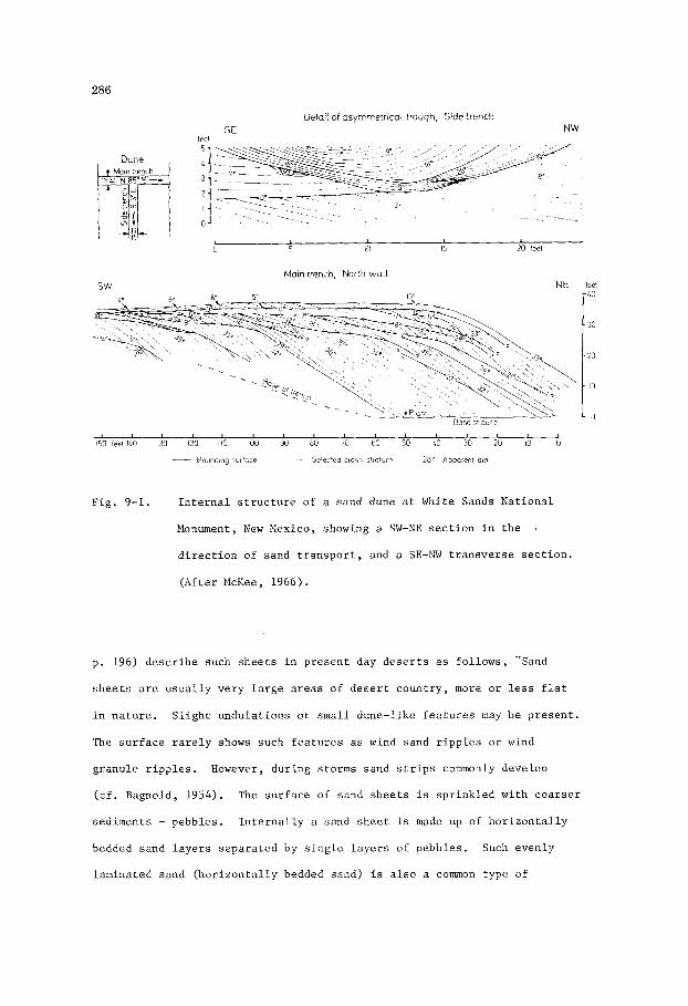
286
-LO
.30
- 20
10
0
Detail of asymmetrical trough, Side trench S E NW
feet 5 -
Mmn trench
fl-
0 5 10 IS 20 Ice1
Main trench, Norlh wall SW NE feet
I isa feet ILO 130 120 110 IOO 90 80 70 60 50 LO 30 20 10 0
- Hoiindlng iurfoce Selected c r o ~ 5 - 5 i i o i u n i 28" Apparent dip
F i g . 9-1. I n t e r n a l s t r u c t u r e o f a s a n d dune a t White Sands N a t i o n a l
Monument, New Mexico, showing a SW-NE s e c t i o n i n t h e I
d i r e c t i o n of s a n d t r a n s p o r t , and a SE-NW t r a n s v e r s e s e c t i o n .
( A f t e r McKee, 1966).
p . 196) d e s c r i b e such s h e e t s i n p r e s e n t day d e s e r t s a s f o l l o w s , "Sand
s h e e t s a r e u s u a l l y v e r y l a r g e areas o f d e s e r t c o u n t r y , more o r less f l a t
i n n a t u r e . S l i g h t u n d u l a t i o n s o r s m a l l dune- l ike f e a t u r e s may b e p r e s e n t .
The s u r f a c e r a r e l y shows such f e a t u r e s as wind sand r i p p l e s o r wind
g r a n u l e r i p p l e s . However, d u r i n g s t o r m s s a n d s t r i p s commonly develop
( c f . Bagnold, 1954). The s u r f a c e of sand s h e e t s is s p r i n k l e d w i t h c o a r s e r
s e d i m e n t s - p e b b l e s .
bedded sand l a y e r s s e p a r a t e d by s i n g l e l a y e r s of p e b b l e s . Such e v e n l y
l a m i n a t e d sand ( h o r i z o n t a l l y bedded sand) i s a l s o a common t y p e of
I n t e r n a l l y a sand s h e e t is made up of h o r i z o n t a l l y

281
bedding i n in t e rdune areas" .
s h e e t s known which a r e devoid of any k ind of pebbles . Such sand s h e e t s
are made up of we l l - so r t ed a e o l i a n sand wi th well-developed h o r i z o n t a l l y
lamina ted sand. A combination of r a p i d sed imen ta t ion , h igh wind v e l o c i t i e s ,
and f a i r l y uniform g r a i n s i z e of t h e sand cause d e p o s i t i o n of s h e e t sand
wi th an abundant ly developed evenly lamina ted sand bedding ( c f . Bagnold,
1954; Glennie , 1970) ."
And f u r t h e r , "There a r e v a s t a r e a s of sand
Reineck and Singh (1974, p . 212) a f t e r Glennie (1970) l i s t t h e
fo l lowing c r i t e r i a as c h a r a c t e r i s t i c of wind-deposited sands .
1.
2 .
3 .
4 .
5.
6 .
7 .
8.
Bedding can be h o r i z o n t a l b u t u s u a l l y e x h i b i t s l a r g e - s c a l e c ross -
-bedding, showing f a i r l y cons t an t o r i e n t a t i o n .
I n d i v i d u a l laminae are w e l l s o r t e d , e s p e c i a l l y i n t h e f i n e r g r a i n
s i z e s ; sha rp g r a i n s i z e d i f f e r e n c e s between lamlnae a r e common.
Gra in s i z e s commonly ranges from s i l t t o coa r se sand. Maximum s i z e
f o r g ranu le s and s m a l l pebbles t r a n s p o r t e d by wind is i n t h e o rde r
of 1 cm, b u t p a r t i c l e s exceeding 5 mm i n d iameter are , rare .
The l a r g e r sand g r a i n s 0.5 - 1.0 mm) t end t o be w e l l rounded.
Clay d rapes are rare.
Sands a r e f r e e of c l ay .
Uncemented q u a r t z g r a i n s e x h i b i t a f r o s t e d s u r f a c e .
Mica is commonly absen t .
E-log C h a r a c t e r i s t i c s
Sand dunes t h a t have been preserved i n a sequence of marine o r
l a c u s t r i n e s h o r e l i n e sands , o r i n r i v e r p o i n t b a r d e p o s i t s , commonly
appear t o b e l a c k i n g i n s t r a t i f i c a t i o n .
t h a t t h e dune d e p o s i t i s i n f a c t cross-bedded, b u t t h a t i t s equid imens iona l
g r a i n s i z e tends t o mask t h e laminae. I n o t h e r dunes, ad jacen t laminae may
be r e a d i l y apparent where they e x h i b i t a marked degree o f v a r i a t i o n i n
Close examination may i n d i c a t e

g r a i n s i z e . But w i t h i n t h e dune as a whole t h e r e is commonly l i t t l e
v a r i a t i o n i n mean g r a i n s i z e from top t o bottom. A l s o , t h e r e is l i t t l e
i n t e r g r a n u l a r material, t h e sands be ing c l e a n and ve ry w e l l s o r t e d .
Winnowing by t h e wind, r epea ted c o n t i n u a l l y , r e s u l t s i n t h e s e g r e g a t i o n of
sands i n t o accumulations of Yrarious b u t c o n s i s t e n t ranges i n g r a i n s i z e .
Subsequent c y c l e s of winnowing, caused by a change of c l i m a t e o r wind
p a t t e r n , may r e s u l t i n t he development of younger ove r - r id ing dunes composed
of sand wi th a d i f f e r e n t mean g r a i n s i z e . Consequently, an accumulation of
sand dunes , t h a t may be more than 100 m t h i c k , w i l l have a c o n s i s t e n t mean
g r a i n s i z e w i t h i n each i n d i v i d u a l dune, bu t may show v a r i a t i o n s , between
dunes. The s e l f - p o t e n t i a l curve r e f l e c t i n g a sequence of supzrimposed
dunes w i l l b e c h a r a c t e r i z e d by i t s c y l i n d r i c a l shape , b u t t h e curve may
show e i t h e r a f a i r l y cons t an t ampl i tude , o r superimposed segments ( r ep res -
e n t i n g superimposed dunes) of d i f f e r e n t ampl i tudes .
Compact i o n
With t h e excep t ion of s m a l l ;and dunes i n r i v e r p o i n t b a r s and
s h o r e l i n e sand b o d i e s , e o l i a n sands are depos i t ed i n d e s e r t environments
on a l a n d s u r f a c e . Th i s l and s u r f a c e may b e an unconformity, o r i t may
c l o s e l y r e p r e s e n t an h i a t u s w i t h i n an a l l u v i a l f a n o r s h e e t hundreds of
f e e t t h i c k . It may a l s o r e p r e s e n t an h i a t u s i n a p a r a l i c t o i n n e r n e r i t i c
environment where a ca rbona te s h e l f o r t i d a l f l a t is exposed by a r e g r e s s i n g
sea t o form an e x t e n s i v e c o a s t a l p l a i n t h a t subsequent ly is encroached upon
by s h e e t s and dunes of sand.
bod ie s such a s d i s c r e t e bu t composite dunes, and on sand s h e e t s o r sand
beds composed of merging dunes w i l l depend on t h e s t r a t i g r a p h i c r e l a t i o n s h i p s
t h a t o b t a i n . Where a sand dune, s imple o r complex, l i e s on an unconformity,
o r on a t h i c k s e c t i o n composed e s s e n t i a l l y of a l l u v i a l f a n sands , i t w i l l
r e t a i n t o a l a r g e degree i ts o r i g i n a l shape , which i s mainly p l a n a r a t t h e
base and convex a t t h e top .
The e f f e c t s of compaction on i n d i v i d u a l sand
But where a dune o v e r l i e s compactible sed iments ,

such as c o a s t a l d e p o s i t s of mud, i t s o r i g i n a l p l a n a r base may be deformed
s o t h a t t h e sand body becomes hi-convex. In t h i s con tex t i t might be
d i f f i c u l t t o d i s t i n g u i s h such a dune, subsequen t ly bu r i ed by marine sed i -
ments, from a t i d a l c u r r e n t sand body (Fig. 7 - 4 ) .
D i s c r e t e e o l i a n sand bod ies of t h i s t ype are t h e excep t ion , and most
wind-deposited sands form beds l y i n g on f a i r l y f l a t s u r f a c e s which have
been b e v e l l e d p r i o r t o o r penecontemporaneously w i t h t h e d e p o s i t i o n of t h e
o v e r l y i n g bed. Compaction of such a bed i s compara t ive ly uniform and does
n o t p r e s e n t problems of morphology d i f f e r e n t from those encountered i n t h e
compaction of sands tone beds of o t h e r o r i g i n s .
With r e f e r e n c e t o t h e e f f e c t s of compaction on t h e p o r o s i t y and
pe rmeab i l i t y of e o l i a n sands , t h e o r i g i n a l d i f f e r e n c e s i n composition
between wind depos i t ed and wa te r - l a in sands are s i g n i f i c a n t . Eo l i an sands
are commonly, b u t n o t always, q u a r t z sands . They are of f a i r l y uniform
g r a i n s i z e , and do n o t have an apprec i ab le o r i g i n a l con ten t of s i l t o r c l a y
depos i t ed as d u s t w i th t h e sand. Exceptions are found i n tHe d e l t a of t h e
Rio Grande R ive r , Texas, where dunes of ex t remely f i n e sand and s i l t a r e
r e f e r r e d t o as ' c l a y dunes ' . D iagene t i c a l t e r a t i o n s r e s u l t i n g from
compaction a f t e r b u r i a l a r e minimal i n most e o l i a n sands , a l though meteor ic
waters moving through a bed of sand may cause some s o l u t i o n and re -prec ip-
i t a t i o n (R i t t enhouse , 1971) r e s u l t i n g i n p i t t i n g of t h e g r a i n s and i n t h e
development of i n t e r g r a n u l a r growths of q u a r t z t h a t dec rease p o r o s i t y and
pe rmeab i l i t y .
space , and compaction has less e f f e c t on them than i t does on sands of
o t h e r o r i g i n s .
i l i t y i s f a i r l y uniform throughout t h e body, a cond i t ion t h a t o b t a i n s i n
some marine sands , but; r a r e l y i n f l u v i a l sands .
I n g e n e r a l , e o l i a n sands r e t a i n much of t h e i r o r i g i n a l pore
In many e o l i a n sands tone bod ies t h e p o r o s i t y and permeab-

290
Ancient Sand Bodies
Among t h e many a n c i e n t e o l i a n sand d e p o s i t s , some c l a s t i c examples
are found i n t h e J u r a s s i c Navajo Sandstone (S tokes , 1961) of t h e Colorado
P l a t e a u , t h e J u r a s s i c Ent rada Formation (Tanner, 1965) of New Mexico, t h e
T r i a s s i c BotucatCl Formation (de Almeida, 1953) of t h e Sdo Paulo area, B r a z i l ,
t h e Permian Coconino Sandstone (McKee, 1969) of t h e Grand Canyon, and t h e
Pennsylvanian t o Permian Caspar Formation (Conybeare and Crook, 1968) of
Wyoming. These sands tone beds e x h i b i t t h e l a r g e - s c a l e , sweeping cross-beds
c h a r a c t e r i s t i c o f sand dunes. F o s s i l sand s h e e t s , on t h e o t h e r hand, do no t
have t h e marked d i a g n o s t i c f e a t u r e s of e o l i a n dunes , and consequent ly have
n o t been r e a d i l y recognized .
Beds of a n c i e n t e o l i a n sands commonly range i n th i ckness t o more than
100 m.
s ands tone (Lessen t ine , 1965) , r anges up t o 300 m. It is of i n t e r e s t t o n o t e
t h a t present-day accumula t ions of sand dunes i n t h e Sahara are known t o
l o c a l l y a t t a i n a t h i ckness o f 200-3C0 m. The Ent rada , which i s b v e r l a i n by
beds of a n h y d r i t i c l imes tone , has an upper sands tone member t h a t is p a r t l y
o f e o l i a n o r i g i n . This sands tone i s desc r ibed by Pe te r son e t aZ. (1965) as
mass ive , orjlnge to grey , f r i a b l e , f i n e t o medium-grained, and ranging i n
t h i c k n e s s up t o 150 f e e t . They r ega rd t h e Ent rada Sandstone a s a porous
and permeable b l anke t sands tone t h a t forms e s s e n t i a l l y one hydro log ic u n i t .
The Coconino Sands tone , which i n cross-bedded ou tc rops resembles t h e Navajo,
is desc r ibed by McKee (1969) a s a we l l - so r t ed q u a r t z sand t h a t forms a
wedge, r ang ing i n th i ckness t o more than 150 m , a c r o s s no r the rn Arizona.
McKee (1969, p. 88) d e s c r i b e s t h e Coconino a s fo l lows:
The Navajo, which i s a h i g h l y porous medium t o f ine -g ra ined q u a r t z
"The most d i s t i n c t i v e s t r u c t u r e i n t h e Coconino i s t h e l a r g e - s c a l e ,
wedge p l a n a r c r o s s - s t r a t i f i c a t i o n t h a t i s prominent ly d i sp layed i n t h e wh i t e
c l i f f f a c e s of t h i s sands tone throughout t h e r eg ion (McKee, 1933). The

291
i n c l i n e d laminae , having d i p s of as much as 34 degrees , have g e n t l y curv ing
s u r f a c e s t h a t i n p l a c e s are 60-70 f e e t long . The b e v e l l e d upper edges of
i n d i v i d u a l sets a r e formed by low ang le e r o s i o n s u r f a c e s t h a t c o n s t i t u t e
t h e bases of h ighe r sets of c r o s s - s t r a t a . Other s t r u c t u r e s t y p i c a l of t h e
Coconino are long , p a r a l l e l r i p p l e marks, w i th rounded crests and o r i e n t e d
w i t h axes p a r a l l e l t o t h e d i p s lopes" .
The above d e s c r i p t i o n i s t y p i c a l of many ou tc rops of a n c i e n t e o l i a n
sands which form massive and magn i f i cen t ly s c u l p t u r e d geo log ica l monuments
i n some of t h e n a t i o n a l pa rks of t h e U.S.A. , and i n o t h e r p a r t s of t h e world.
The Botucatfi Formation, which ex tends southward from B r a z i l i n t o Uruguay
and Argen t ina , is of p a r t i c u l a r i n t e r e s t because i t may b e , accord ing t o
Sanford and Lange (1960), t h e l a r g e s t cont inuous e o l i a n d e p o s i t i n t h e
wor ld , cover ing an a r e a of more than 1,300,000 sq . km. Th i s format ion ,
which commonly ranges i n th i ckness up t o 200 m b u t is more than 300 m t h i c k
i n t h e SQo Paulo area, c o n s i s t s of f i n e t o medium-grained qua r t zose sands tone .
The sand g r a i n s are w e l l rounded, have p i t t e d s u r f a c e s , and ?re covered wi th
a r ed f e r rug inous pigment.
c h a r a c t e r i s t i c e o l i a n cross-bedding s imi la r t o t h a t of t h e Coconino
desc r ibed above.
o v e r l a i n by Upper T r i a s s i c vo lcan ic s .
A s t r i k i n g f e a t u r e o f t h e ou tc rops i s t h e
The Botucatci l i e s on an unconformity and is unconformably
The Botucatci h a s good p o r o s i t y and pe rmeab i l i t y , and i n favourable
s t r a t i g r a p h i c and s t r u c t u r a l cond i t ions could be a p o t e n t i a l l y a t t r a c t i v e
r e s e r v o i r bed f o r o i l o r gas . Sanford and Lange (1960, p. 1344) say , "In
t h e s t a t e of Sgo Paulo are l a r g e a r e a s i n which t h e s e sands tones are impreg-
na t ed wi th r e s i d u a l a s p h a l t de r ived from o i l s eep ing up through f a u l t s " .
O i l and Gas F i e l d s
R e f e r r i n g t o t h e economic s i g n i f i c a n c e of e o l i a n d e p o s i t s , S e l l e y
(1970, p. 63) s a y s , "Eol ian sands tones are p o t e n t i a l l y of h igh p o r o s i t y and

292
pe rmeab i l i t y because they are t y p i c a l l y well-rounded, we l l - so r t ed , and
gene ra l ly only l i g h t l y cemented.
good due t o absence of s h a l e in t e rbeds . Because of these f e a t u r e s e o l i a n
sandstones can be important a q u i f e r s and hydrocarbon r e sd rvo i r s " . Se l l ey
i s of t he opinion t h a t i n gene ra l e o l i a n d e p o s i t s can be r a t e d as poor
p rospec t s because they commonly occur w i t h i n c o n t i n e n t a l b a s i n s , although
t h e s e may o v e r l i e , o r be o v e r l a i n by a sequence of marine t o p a r a l i c s t ra ta
t h a t i n c l u d e s source beds f o r o i l o r gas . The Lower Permian Rotl iegendes
red-beds of northwest Europe and t h e North Sea con ta in examples of gas-
-bear ing e o l i a n sandstones ove r ly ing source beds.
Regional pe rmeab i l i t y i s l i k e l y t o be
North Sea Gas F i e l d s
Major gas f i e l d s producing from t h e Rotl iegendes i n t h e North Sea
i n c l u d e Groningen on t h e n o r t h coas t of t h e Nether lands, and I n d e f a t i g a b l e ,
Leman, and West Sole i n B r i t i s h waters o f f t he coas t of E a s t Anglia and
L inco lnsh i r e . The Rotl iegendes, which inc ludes e o l i a n and o t h e r d e s e r t
environment sands tones , l i e s unconformably on Carboniferous c o a l nieasures.
Glennie (1972) shows t h a t t h e d i s t r i b u t i o n of t h e Rotl iegendes i s confined
t o northwest Europe and t h e southern p a r t of t h e North Sea where i t extends
t o t h e east coas t of England. From south to no r th t h e f a c i e s grade from
those formed i n a f l u v i a t i l e environment cha rac t e r i zed by wadis, t o d e s e r t
sand dunes formed on a c o a s t a l p l a i n , and f a r t h e s t no r th t o s h a l y sediments
and e v a p o r i t e s on a t i d a l p l a i n s i m i l a r t o t h e p re sen t day sabkha environment
of t he Pe r s i an Gulf. With r e f e r e n c e t o t h e th i ckness and l i t h o l o g i c
v a r i a t i o n s of t h e s e beds, Kent (1967, p . 739) remarked, "It i s no t p o s s i b l e
a t t h e p r e s e n t t i m e t o comment on t h e r e g i o n a l v a r i a t i o n of t h e Lower
Permian Rotl iegendes. The c r i t i c a l p o i n t is t h a t i t inc ludes the main
o b j e c t i v e of t he North Sea gas sea rch : a b a s a l sandstone u n i t w i th a
th i ckness i n some p laces measured i n hundreds of f e e t . This sandstone
con ta ins i n the discovery f i e l d s a t Slochteren and probably elsewhere an

293
important
and permeabi l i ty" .
t h e n o r t h coas t of t h e Nether lands. Some f i v e y e a r s l a t e r , with r e fe rence
t o s e c t i o n s i n the southwestern and sou th -cen t r a l p a r t s of t h e Rotl iegendes
b a s i n , Glennie (1972, p. 1055) was a l s o r e t i c e n t about quan t i fy ing th i ckness
o r gene ra l l i t h o l o g y and s t a t e d , "Total t h i ckness and r e l a t i v e p ropor t ions
of each f a c i e s change from p lace t o p l a c e , hence no scale can be given. One
o r more of t hese sedimentary f a c i e s may be absen t i n any p a r t i c u l a r area".
p ropor t ion of almost uncemented dune sandstone of high p o r o s i t y
The S loch te ren w e l l s are s i t u a t e d n e a r Groningen on
In g e n e r a l , t h e Rotl iegendes comprises a lower u n i t of conglomeratic
sandstone interbedded wi th cross-bedded sands tone , and an upper u n i t of
we l l - so r t ed , p l a n a r cross-bedded sandstone which i s o v e r l a i n by beds of
dolomite and evapor i t e s . The lower u n i t i s i n t e r p r e t e d by Glennie (1972)
as comprising dune and f l u v i a t i l e sands formed i n a mixed e o l i a n and wadi
environment.
These gas-bearing sandstones form a f a c i e s which is d i s t r i b u t e d from
Groningen west t o England, covering an a r e a approximately 1,OOd km long and
up t o 300 km wide. The Rotl iegendes b a s i n , as a whole, a l s o t r ends east-
- w e s t and i s up t o 2,000 km long and 500 km wide.
The upper u n i t he i n t e r p r e t s as an accumulation of sand dunes.
The geo log ica l h i s t o r y of t h e s e gas-bearing sands and a s s o c i a t e d
beds has been o u t l i n e d by Glennie (1972). U p l i f t and l e v e l l i n g of t h e
Carboniferous c o a l measures was accompanied by the in l and r eg res s ion of an
escarpment i n c i s e d by wadis and f lanked by a l l u v i a l fans .
formed a s h e e t of dunes over a p l a i n extending t o t h e sabkhas which f r inged t h e
c o a s t l i n e of a l a r g e in l and body of s a l t water.
t h i s d e s e r t sea over the c o a s t a l p l a i n r e s u l t e d i n reworking of t h e uppermost
p a r t of t h e dune sands , and subsequent ly i n depos i t i on of t h e Kupferschiefer ,
t h e cupr i f e rous s h a l e s t h a t are t h e b a s a l u n i t of t h e Zechstein evapor i t e s .
Wind-blown sands
Subsequent t r ansg res s ion of
With r e fe rence t o t h e l i t h o l o g y of t h e gas-bearing dune sands
Glennie (1972, p. 1058) s a y s , "The g r a i n s i z e of t hese sands ranges from
294
very f i n e t o medium and, l o c a l l y , p a r t i c u l a r l y n e a r t h e base of an i n t r a -
fo rma t iona l sequence , may be coa r se . The f i n e r g r a i n s are subangular and
t h e c o a r s e r ones subrounded o r , r a r e l y , rounded. F ros t ed g r a i n s a r e common.
No a r g i l l a c e o u s material i s p r e s e n t a p a r t from a u t h i g e n i c c l a y . The
sands tones g e n e r a l l y are cemented wi th hemat i t e and a u t h i g e n i c c l a y , bu t
l o c a l l y dolomi te and a n h y d r i t e are impor tan t as cements, t o g e t h e r w i th
minor a u t h i g e n i c q u a r t z . Depending on t h e amount of cement p r e s e n t , t h e
sands tone may b e ha rd o r q u i t e f r i a b l e .
t h e s e sands tones form t h e main r e s e r v o i r rock f o r t h e Rot l iegendes gas".
Where primary p o r o s i t y is p rese rved ,
According t o Glennie (1972) t h e probable p roduc ib le r e s e r v e s of gas
from known major f i e l d s w i t h i n t h e Rot l iegendes amount t o about 2,500
b i l l i o n (thousand m i l l i o n ) cub ic meters. Th i s i s t h e e q u i v a l e n t of 85
t r i l l i o n ( m i l l i o n m i l l i o n ) cub ic f e e t . Th i s amount i n c l u d e s 1,800 b i l l i o n
cub ic meters i n t h e Groningen f i e l d and 700 b i l l i o n cub ic meters i n o f f -
-shore North Sea F i e l d s ( I n d e f a t i g a b l e , Leman, and West So le ) . Add i t iona l
r ecove rab le r e s e r v e s o f about 250 b i l l i o n cub ic meters (8.5 t r i l l i o n cub ic
f e e t ) are e s t ima ted t o b e conta ined i n smaller f i e l d s y i e l d i n g gas from the
Rot l iegendes i n t h e Nether lands and West Germany.
Hassi R ' M e l and Houd Berkaoui G a s and O i l F i e l d s , A lge r i a
The Hassi R ' M e l Gas F i e l d and t h e Houd Berkaoui O i l F i e l d s a r e
s i t u a t e d 600 km and 800 km r e s p e c t i v e l y s o u t h e a s t of Oran, A lge r i a .
of t h e s e f i e l d s are producing from g e n t l y e longa te domes w i t h i n Lower
Triassic sands tones which unconformably o v e r l i e an undu la t ing s u r f a c e of
Pa leozo ic ( i n par t Cambro-Ordovician) rocks . The dome s t r u c t u r e s appear
t o r e s u l t from d rap ing of t h e Lower Triassic sands tones over b u r i e d h i l l s
of Pa leozo ic rock . These sands tones , which have n o t been named, are
desc r ibed by A l i (1973). They cover an area o f a t least 150,000 sq km i n
no r thwes te rn A l g e r i a , and range i n th i ckness up t o 200 m depending on t h e
topography of t h e unde r ly ing Pa leozo ic . I n t h e no r th -cen t r a l area of t h e
Alge r i an Sahara t h e Lower T r i a s s i c l i es d i r e c t l y on t h e Precambrian.
Both

295
The Lower T r i a s s i c has been divided by A l i (1973) i n t o fou r u n i t s a s
fol lows: a b a s a l S e r i e s I n f e r i o r comprising 70 m of s h a l e , andes i t e and
sandstone; a lower u n i t "C" c o n s i s t i n g of 50 m of sandstone; a middle u n i t
con ta in ing 40 m of sha le and sandstone; and an upper u n i t "A" of I 1 II B
quartzose sandstone having a thickness i n the range 10-30 m.
conformably o v e r l a i n by s h a l e and evapor i t e s .
t h e main r e s e r v o i r i s Unit"A", whereas i n t h e Houd Berkaoui F ie ld
product ion i s obtained l a r g e l y from sandstone beds i n t h e S e r i e s I n f e r i o r .
A l i (1973) desc r ibes Unit "A" a s f i n e t o medium-grained, cons i s t ing of
sub-rounded g r a i n s , p a r t l y cemented with anhydri te . The sandstone is
f a i r l y w e l l s o r t e d and has f a i r t o good p o r o s i t y ranging up t o 16%.
Sandstone beds i n the S e r i e s I n f e r i o r a r e f i n e t o coarse-grained. I n
gene ra l , t h e Lower T r i a s s i c sandstones a r e qua r t zose , c o n s i s t i n g of
sub-rounded t o sub-angular g ra ins . Po ros i ty i s commonly i n t h e range
12-15% but ranges up t o 20%. Permeabi l i ty averages 500 mi l l i da rcys and
ranges up t o 1,300 mi l l i da rcys .
Unit "A" is
In t h e Hassi R ' M e l F i e l d ,
A l i (1973) s t a t e s t h a t gas r e se rves i n Hassi R'Mel F ie ld a r e
es t imated t o be 70 t r i l l i o n cub ic f e e t (1,960 b i l l i o n cubic metres) .
No e s t ima tes of product ion c a p a b i l i t i e s a r e given f o r Houd Berkaoui
F i e l d which contains 13 m of n e t sand.
No f o s s i l s have been found i n the Lower T r i a s s i c sandstones i n
the northwestern p a r t of t h e Algerian Sahara. The sandstones l i e
unconformably on a gen t ly undulat ing e r o s i o n a l su r f ace of Paleozoic and
Precambrian rocks and a r e conformably o v e r l a i n by a Middle t o Upper
T r i a s s i c e v a p o r i t i c sequence. These s t r a t i g r a p h i c r e l a t i o n s h i p s a r e
s i m i l a r t o those of t h e Rotliegendes i n the North Sea a rea and suggest
t h a t t h e Lower T r i a s s i c gas and oi l -bear ing sandstones of Algeria a r e
l a r g e l y non-marine and probably, i n p a r t a t l e a s t , of e o l i a n o r i g i n .

This Page Intentionally Left Blank

297
REFERENCES
A l b e r t a Government, 1969. Reserves report , O i l and Gas Cowervat ion Board.
A l b e r t a Research Counci l , 1963. Athabasca o i l sands : a symposium. K.A. C la rk V O ~ . , Information ser . 45.
A l b e r t a SOC. P e t r o l . G e o l o g i s t s , 1959. Oil Fie lds of Alberta. 272 pp. Supplement. 1966, 136 pp.
A l b e r t a SOC. P e t r o l . G e o l o g i s t s , 1964. Geological h i s to ry o f Westertl Canada.
A l i , O . , 1973. S t r a t i g r a p h y of Lower T r i a s s i c s ands tone o r nor thwes t A lge r i an Sahara , A l g e r i a . BuZl. Am. Assoc. Pet ro l . Geologists, 57: 528-540.
A l l en , J . R . L . , 1965a. La te Quaternary Niger Delta and a d j a c e n t a r e a s ; sed imentary envi ronments and l i t h o f a c i e s . Bul l . Am. Assoc. Petrol . Geologis ts , 49: 547-600.
A l l e n , J.R.L., 1965b. Coas t a l geomorphology of e a s t e r n N i g e r i a - beach- - r i d g e b a r r i e r i s l a n d s and vege ta t ed t i d a l f l a t s . Geol. Mij’nbow, 27: 1-21.
A l l e n , J . R . L . , 1965c. A review of t h e o r i g i n and c h a r a c t e r i s t i c s of Recent a l l u v i a l sed iments . Sedimentology, 5: 1 9 1 pp.
A l l e n , J . R . L . , 1965d. The sed imen ta t ion and paleogeography of t h e Old Red Sands tone of Anglesey, North Wales. Proc. Yorkshire Geol. Soc., 35: 152.
A l l en , J .R .L. , 1970. Sediments of t h e modern Niger Delta: a summary and review. in D e l t a i c s ed imen ta t ion , modern and a n c i e n t . Morgan, J .P . and Shaver , R.B. (eds . ). Soc. Econ. Paleontologis ts Mineralogists, Spec. PdZ., 15 : 138-151.
A l l e n , J . R . L . , 1970. Physical processes o f sedimentation. Al len and Unwin, London, 248 pp.
Andresen, M . J . , 1962. Pa leodra inage p a t t e r n s : t h e i r mapping from s u b s u r f a c e d a t a , and t h e i r pa leogeographic va lue . Bul l . Am. Assoc. Petrol,. Geologis ts , 46: 398-405.
A t t i a , M . I . , 1954. Deposits i n t h e Nile Val ley and Delta of E g y p t . Geol. Surv. Egypt, 356 pp.
Azad, J., Bhat tacharyya , S . , D a t t a , B . D . and Stevens , T.E., 1971. Hydrocarbon accumula t ion i n t h e Nahorka t iya o i l f i e l d , A s s a m . i n Geologica l and e x p l o r a t i o n . Proc. 8 t h World Petrol . Gong-. ,
. 2 : 259-268.
Baars , D . L . , 1961. Permian b l a n k e t s ands tones of Colorado P l a t e a u . i n Geometry of s ands tone bod ies . Am. Assoc. Pet ro l . Geologists, Spec. Publ., 179-219.

298
Baars, D.L. and Seager , W.R., 1970. S t r a t i g r a p h i c c o n t r o l o f pe t ro leum i n White R i m Sands tone (Permian) i n and n e a r Canyonlands Na t iona l Pa rk , Utah. B u l l . Am. Assoc. Petrol. Geologists, 54: 709-718.
Bagnold, R.A. , 1941. The physics of blown sand and desert dunes. Methuen, London, 265pp.
Baker, A .A. , 1946. Geology o f t h e Green River Desert C a t a r a c t Canyon r e g i o n , Emery, Wayne, and G a r f i e l d Coun t i e s , Utah. U.S. Geol. Surv., Bul l . , 951: 122 pp.
Baker, F .E . , 1957. H i s t o r y of t h e S a l t Creek o i l f i e l d . i n Wyoming o i l and g a s f i e l d s : a symposium. Publ. Wyoming Geol. Assoc.
B a l l Associates, L td . , 1965. Su r face and sha l low o i l - impregnated rocks and sha l low o i l f i e l d s i n t h e Uni ted S t a t e s . U.S. Bur. Mines, Monograph, 12: 375 pp.
B a l l , M.W. , 1935. Athabaska o i l sands : appa ren t example of l o c a l o r i g i n of o i l . Bul l . Am. Assoc. Petrol. Geologists, 19 : 153-171.
B a l l , M.W., Weaver, T . J . , C r i d e r , H.D. and B a l l , D.S . , 1941. S h o e s t r i n g gas f i e l d s of Michigan. i n S t r a t i g r a p h i c t y p e o i l f i e l d s . Am. Assoc. Petrol. Geologist, Spec. Publ., 237-266.
Barlow, J . A . and Haun, J . D . , 1966. Regional s t r a t i g r a p h y of F r o n t i e r Formation and r e l a t i o n t o S a l t Creek F i e l d , Wyoming. Bul l . Am. Assoc. Petrol. ,;eologists, 50: 2185-2196.
Barrell , J., 1912. Criteria f o r t h e r e c o g n i t i o n o f a n c i e n t d e l t a deposi:s. Bull. Geol. Soc. A m . , 23: 377-466.
Bartow, J . A . , 1966. Deep submarine channel i n Upper Miocene, Orange County, C a l i f o r n i a . J . Sediment. Petrol., 36: 700-705.
Bass, N . W . , 1934. O r i g i n of B a r t l e s v i l l e s h o e s t r i n g sands , Greenwood and B u t l e r Count ies , Kansas. BUZZ. Am. Assoc. Petrol. Geologists, 18: 1313-1345.
Bass, N . W . , 1936. O r i g i n of s h o e s t r i n g sands of Greenwood and B u t l e r Coun t i e s , Kansas. Kansas GeoZ. S u m . , Bull., 23.
Bass, N . W . , 1941. S i g n i f i c a n c e of i n i t i a l d a i l y p roduc t ion of w e l l s i n Burbank and South Burbank o i l f i e l d s , Oklahoma. BUZZ. Am. Assoc. PetroZ. Geologists, 25: 1175-1179.
Bass, N.W. , Lea thercock , C . , D i l l a r d , W.R. and Kennedy, L . E . , 1937. O r i g i n and d i s t r i b u t i o n o f B a r t l e s v i l l e and Burbank s h o e s t r i n g o i l sands i n p a r t s of Oklahoma and Kansas. f i u l l . h i . Assoc. Petrol. Geologists, 21: 30-66.
Bates, C . C . , 1953. R a t i o n a l t h e o r y of d e l t a format ion . BUZZ. Am. Assoc. Petrol. Geologists, 37: 2119-2162.
Bauer, E . J . , 1967. Genes is o f Lower Cre taceous "A" Sands tone , RecGncave Bas in , B r a z i l . Bull . Am. Assoc. Petrol. Geologists, 51: 28-54.
Beach, F.K., e t a l . , 1961. Sedimentology of r e c e n t and f o s s i l n e a r s h o r e d e p o s i t s . J . Can. Oil and Gas industries, J u l y , 25-28.
299
Beck, E . , 1929. S a l t Cr-ek o i l f i e l d , Yat rona County, Wyoming. i n S t r u c t u r e o f t y p i c a l American o i l f i e l d s . Am. Assoc. Petrol . Geologists, Spec. Publ . , 2: 589-603.
Beck, R.H. and Lehner, P . , 1974. Oceans, new f r o n t i e r s iu e x p l o r a t i o n . Bull. Am. Assoc. Petrol . Geologists, 58: 376-395.
Beddoes, L.R., 1973. O i l and gas f i e l d s of Austral ia , P a p a New Guinea and New Zealand. Trace r P e t r o l . and Mining Pub l . , Sydney, 382 pp.
Beebe, B.W. and C u r t i s , B.F. ( e d s . ) , 1968. N a t u r a l gases of North America. Am. Assoc. Petrol . Geologists, Memoir, 9 : 2493 pp.
Bein , J . , G r i f f i t h , B.R. and Svalbe , A . K . , 1973. The Kingf i sh f i e l d - o f f s h o r e Gippsland Basin. J a w . Aust. Petrol . E q l . Assoc., 13: 68-72.
Berg, R . R . , 1968. Poin t -bar o r i g i n o f F a l l R ive r Sands tone r e s e r v o i r s , n o r t h e a s t e r n Wyoming. B u l l . Am. Assoc. Petrol . Geologists, 52: 2116-2122.
Berg, R.R. and Davies , D.K. , 1968. Or ig in o f Lower Cre taceous Muddy Sands tone a t B e l l Creek F i e l d , Montana. Bul l . Am. Assoc. Petrol . Geologists, 52: 1888-1898.
Bergant ino , R .N. , 1971. Submarine r e g i o n a l geomorphology o f t h e Gulf of Mexico. Bull . Geol. Soc. Am. , 82: 741-752,
Berger , W.R. , 1919. Tne e x t e n t and interpretation of t h e Hogshooter gas f i e l d . Bull. Am. Assoc. Petrol . Geologists, 3: 212-16.
Berger , W.R. , 1921. The r e l a t i o n between t h e s t r u c t u r e and t h e p roduc t ion i n t h e S a l l y a r d s f i e l d , Kansas. Bull. Am. Assoc. Petrol . Geologists, 5 : 276-281.
Bernard, H .A. , 1965. A resum6 o f r i v e r d e l t a t ypes . Bull. Am. Assoc. Petrol. Geologists, A b s t r . , 49: 334-335.
Bernard , H.A. , Major, C.F. and P a r r o t t , B . S . , 1959. The Galves ton b a r r i e r i s l a n d and env i rons : a model f o r p r e d i c t i n g r e s e r v o i r occu r rence and t r e n d . Trans. Gulf Coast Assoc. Geol Soc., 9: 221-224.
Bernard , H . A . , Le Blanc, R . J . and Major, C.F., 1962. Recent and P l e i s t o c e n e geology of southwes t Texas. i n Geology of G u l f Coast and c e n t r a l Texas. Houston Geol. Soc. , f J , J ; ( j < ) , I ~ k , 175-224.
Bernard , H . A . and Major, C.F., 1963. Recent meander b e l t d e p o s i t s of t h e Brazos River : an a l l u v i a l ' sand ' model. Bull . Am. Assoc. Petrol . Geologists, A b s t r . , 47: 350.
Bernard , H.A. and L e Blanc , R . J . , 1965. R6sum6 of Quaternary geology of t h e no r thwes te rn Gulf o f Mexico province . i n The Quaternary o f t h e United S t a t e s . P r i n c e t o n Univ. P r e s s , 137-185.
B e r s i e r , A . , 1958. Sgquences d g t r i t i q u e s e t d i v a g a t i o n s f l u v i a l e s . Eclogae Geol. Heluetiae, 51: 854-893.
Berven, R . J . , 1966. Cardium sands tone b o d i e s , Cross f i e ld -Gar r ing ton area, Albe r t a . Bull . Canadian Petrol. Geol., 14: 208-240.
300
B e u t n e r , E . C . , F l u e c k i n g e r , L.A. and Gard, T.M., 1967. Bedding geometry i n a P e n n s y l v a n i a n c h a n n e l s a n d s t o n e . B ~ i l l . GeoZ. Soc. Am., 78: 911-915.
B i g a r e l l a , J . J . , 1972. E o l i a n envi ronments : t h e i r c h a r a c t e r i s t i c s , r e c o g n i t i o n , and impor tance . i n R e c o g n i t i o n of a n c i e n t s e d i m e n t a r y envi ronments . Soc. Econ. Paleontologists Mineralogists, Spec. PubZ., 1 6 : 12-62.
B i l l i n g s Geol . SOC., 1958. Moncanu oil and gas fi-lds.
B i l l i n g s Geol . SOC., 1966. J u r a s s i c and C r e t a c e o u s s t r a t i g r a p h i c t r a p s , S w e e t g r a s s Arch: a symposium. , ;u;d h o r > i c , 1 7 t h Annual F i e l d Conf.
Bishop, M.S., 1960. S & s i ~ ~ ~ f a c e mapping. John Wiley and Sons, New York, 1 9 8 pp.
Blackwelder , E . , 1928. Mudflow as a g e o l o g i c a g e n t i n s e m i - a r i d mounta ins . Oul,L. i;eo?l. Soc. Am., 39: 465-483.
B l a t t , H . , Middle ton G . , and Murray, R . , 1972. rocks. P r e n t i c e - H a l l , I n c . , 634 pp.
Origin of sedimentary
B l i s s e n b a c h , E . , 1954. Geology o f a l l u v i a l f a n s i n s e m i - a r i d r e g i o n s . Bull. GeoZ. Soc. Am., 65: 175-190.
B l i x t , J . E . , 1941. Cut Bank o i l and g a s f i e l d , G l a c i e r County, Montana. in S t r a t i g r a p h i c t y p e o i l f i e l d s . Am. Assoc. Petrol . Geologists, Spec. Publ., 327-381.
Bloesch , E . , 1919. U n c o n f o r m i t i e s and t h e i r i m p o r t a n c e i n p e t r o l e u m geology. B u l l . Am. Assoc. Petrol . Geologists, 3: 276.
Boggs, S . , 1974. Sand-wave f i e l d s i n Taiwan S t r a i t . Geology, 2: 251-253.
Bolyard , D.W. and McGregor, A .A. , 1966. S t r a t L g r d p h y and p e t r o l e u m p o t e n t i a l i n Lower C r e t a c e o u s I n y a n Kara Group i n n o r t h e a s t e r n Wyoming, and western South Dakota . Bull . Am. Assoc. Petrol . Geologists, 50: 2221-2244.
Borden, J .F . and B r a n t , K .A. , 1941. E a s t Tuskegee P o o l , Creek County, Oklahoma. i n S t r a t i g r a p h i c t y p e o i l f i e l d s . Am. Assoc. Petrol . Geologists, S ~ Q C . P u b l . , 436-455.
B o r n h a u s e r , M . , 1948. P o s s i b l e a n c i e n t submar ine canyon i n s o u t h w e s t e r n L o u i s i a n a . Bull. Am. Assoc. P p t r o l . Geologists, 32: 2287-2294.
Boyd, U . R . and Dyer, B.F., 1964. F r i o b ? r r i e r b a r s y s t e m o f South Texas . Trans. 7 u l f Coast Assoc. GeoZ. Soc., 1 4 : 309-322.
B o t v i n k i n a , L.N. and Yablokov, V . S . , 1964. S p e c i f i c f e a t u r e s of d e l t a i c d e p o s i t s i n c o a l - b e a r i n g and c u p r i f e r o u s f o r m a t i o n s . i n Dpltaic and shallow mari f la deposits. E l s e v i e r , Amsterdam, 39-47.
B r a u n s t e i n , J., (compiled b y ) , 1974. F a c i e s and t h e r e c o n s t r u c t i o n o f envi ronments . Am. Assoc. Petrol . Cpoloyistz, H,print &P. , 10: 224 pp .

301
Brenner, k.L. and b a v i e s , G.L . , 1974. Oxford ian sed imen ta t ion i n wes te rn i n t e r i o r Uni ted S t a t e s . BUZZ. Am. Assoc. Petrol . Geologists, 5 8 : 407-428.
B r i c e , J . C . , 1964. Channel p a t t e r n and t e r r a c e s o f t h e Loup Rivers i n Nebraska. U.S. Geoz. Surv., Profess . Pap., 422-D, 4 1 pp.
Brouwer, A. , 1953. Rhythmic d e p o s i t i o n a l f e a t u r e s of t h e East Surinam c o a s t a l p l a i n . Geol. Mijnbouw, 15: 226-236.
Brown, L.F., e t u Z . , 1967. Role o f compaction i n development of geometry of superposed e l o n g a t e sands tone bod ies . Bull. Am. Assoc. PetroZ. Geologists, 51: 455-456.
Brown, L.F. , 1969. Geometry and d i s t r i b u t i o n of f l u v i a l d e l t a i c s ands tones (Pennsylvanian and Permian) n o r t h - c e n t r a l Texas. Trans. Gulf Coast Assoc. Geol. Soc., 19 .
B u l l , W.B. , 1968. A l l u v i a l f ans . Jour. GeoZ. Educ., 16: 101-106.
B u l l , W . B . , 1972. Recogni t ion o f a l l u v i a l - f a n d e p o s i t s i n t h e s t r a t i g r a p h i c r eco rd . i n Recogni t ion o f a n c i e n t sed imentary environments. Soc. Econ. Pa Zeontologis t s Mineralogists, Spec. P u b l . , 16: 63-83.
Burke, K . , 1972. Longshore d r i f t , submarine canyons, and submarine f a n s i n development of Niger Delta. BUZZ. Am. Assoc. Petrol. Geologists, 56: 1975-1983.
Busch, D . A . , 1950. AppZied sedimentation. John Wiley and Sons, New York, 559 pp.
Busch, D.A. , 1953. The s i g n i f i c a n c e of d e l t a s i n subsu r face e x p l o r a t i o n . Tulsa Geol. Soc., Digest, 21: 71-80.
Busch, D . A . , 1959. P rospec t ing f o r s t r a t i g r a p h i c t r a p s . Bull . Am. Assoc. Petrol . GeoZ., 43: 2829-2843.
Busch, D.A. , 1961. Make t h e most o f t h o s e e l e c t r i c l o g s i f you want t o f i n d s t ra t t r a p s . O i l and Gas Jour. , 59: 162-167.
Busch, D . A . , 1971. Gene t i c u n i t s i n d e l t a p rospec t ing . BUZZ. Am. Assoc. Petrol . Geologists, 55: 1137-1154.
Busch, D.A. , 1974. S t r a t i g r a p h i c t r a p s i n sands tone - e x p l o r a t i o n techniques . Am. Assoc. Petrol . Geologists, Mern., 21 : 190 pp.
Cadman, W.K. , 1927. The Golden Lanes o f Greenwood County, Kansas. BUZZ. Am. Assoc. Petrol. Geologists, 11: 1151-1172.
Ca r twr igh t , D . E . , 1959. On submarine sand-waves and t i d a l lee-waves. Proc. RoyaZ Soc., Series A , 253: 218-241.
Ca r r igy , M . A . , 1971. Deltaic sed imen ta t ion i n Athabasca tar sands . Bull . Am. Assoc. Petrol . Geologists, 55: 1155-1169.
Ca r r igy , M.A. and Zamora, W . J . , 1960. The Athabasca o i l sands . i n AZberta Soc. P P ~ Y ’ o ~ . Coologiists, Spec. Publ., 38-49.

302
Casey, S.R. and C a n t r e l l , R .B . , 1941. Davis s a n d l e n s , Hardin f i e l d , L i b e r t y County, Texas. i n S t r a t i g r a p h i c t y p e o i l f i e l d s . Am. Assoe. Pet ro l . Geologis ts , Spec. P d l . , 564-599.
Chapman, R . E . , 1973. Petr>oleum geology, a concise s tudy. E l s e v i e r , Amsterdam, 304 pp.
C h a r l e s , H . H . , 1941. Bush C i t y o i l f i e l d , Anderson County, Kansas. i n S t r a t i g r a p h i c t y p e o i l f i e l d s . Am. Assoc. Pe t ro l . Geologis ts , Spec. Publ., 43-56.
Cheyney, A.E. , 1929. Madison S h o e s t r i n g P o o l , Greenwood County, Kansas. i n S t r u c t u r e of t y p i c a l American o i l f i e l d s . Am. Assoc. Pe t ro l . Geologis ts , Spec. Puhl . , 150-159.
C h i l t o n , J . R . , 1959. Red E a r t h F i e l d . i n O i l f i e l d s of A l b e r t a . Alber ta Soe. Pe t ro l . Geologis ts , Spec. Publ., 178-179.
Chowdhury, M . I . , 1966. On t h e g r a d u a l s h i f t i n g of t h e Ganges from w e s t t o east i n d e l t a - b u i l d i n g o p e r a t i o n s . i n S c i e n t i f i c problems o f t h e humid t r o p i c a l zone d e l t a s and t h e i r i m p l i c a t i o n s . UNESCO, Proc. Dacca Symposium, 35-40.
C h r i s t i e , H . H . , 1971. Mi tsue o i l f i e l d : a r i c h s t r a t i g r a p h i c t r a p . i n G e o l o g i c a l and e x p l o r a t i o n . Proc. 8 th World Pptrol . Congr., 2 : 269-274.
C l a r k , D . A . , 1961. Pr imary s t r u c t u r e s of t h e Halfway Sand i n t h e M i l l i g a n Creek o i l f i e l d , B r i t i s h Columbia. J . Alberta Soe. Pe t ro l . Geologists, 9: 109-130.
C l a r k , R.H. and Rouse, J . T . , 1971. A c l o s e d sys tem f o r generait ion and en t rapment of hydrocarbons i n Cenozoic d e l t a s , L o u i s i a n a Gulf Coas t . B u l l . Am. Assoc. Pe t ro l . Geologis ts , 55: 1170-1178.
C l e a v i n g e r , H . B . , 1974. Pa leoenvi ronments of d e p o s i t i o n of t h e Upper C r e t a c e o u s F e r r o n Sands tone n e a r Emery, Emery County, Utah. Brigham Young iiniv., GeoZ. S t u d i e s , 21 : 247-274.
C o a s t a l Research Group, 1969. C o a s t a l envi ronments of n o r t h e a s t e r n M a s s a c h u s e t t s and New Hampshire. D ~ p t . G ~ o l . Uniu. Mass., C. R. C. Contribut ion, 1.
Coleman, J . M . and Gagl iano , S.M., 1965. Sedimentary s t r u c t u r e s , M i s s i s s i p p i R i v e r d e l t a i c p l a i n s . i n Primary sed imentary s t r u c t u r e s and t h e i r hydrodynamic i n t e r p r e t a t i o n : a symposium. Soc. Econ. Paleontologis ts Mineralogists, Spec. Publ., 1 2 : 133-148.
Coleman, J . M . , 1969. Brahmaputra R i v e r : c h a n n e l p r o c e s s e s and s e d i m e n t a t i o n . Sediment. Geol., 3: 132-239.
C o l l e y , B . B . , 1963. Libya: pe t ro leum geology and development. 6 t h World Pe t ro l . Congr., Frankfurt , Sect ion 1 , 43: 10 pp.
Conant, L.C. and Goudarz i , G . H . , 1967. S t r a t i g r a p h i c and t e c t o n i c framework o f Libya . B u l l . Am. Assoc. Pe t ro l . Geologists, 51: 719-730.
C o n a t s e r , W . E . , 1971. Grande I s l e : a b a r r i e r i s l a n d i n t h e Gulf o f Mexico. Bull. Am. Assoc. Pe t ro l . Geologis ts , 8 2 : 3049-3068.

303
C o n o l l y , J . R . , 1968. Submarine canyons o f t h e c o n t i n e n t a l margin , east Bass S t r a i t ( A u s t r a l i a ) . Marine Geol., 6 : 449-461.
C o n o l l y , J . R . and C l e a r y , W . J . , 1971. B r a i d e d d e e p sea d e l t a s and t h e o r i g i n o f t u r b i d i t e s a n d s ( A b s t r . ) . Trans. Am. Geophys. Union, 52: 244.
Conybeare, C .E .B . , 1964. O i l a c c u m u l a t i o n i n a l l u v i a l s t r a t i g r a p h i c t r a p s . Aust. O i l and Gas J . , 1 0 : 44-48.
Conybeare, C . E . B . , 1966. O r i g i n o f Athabasca o i l s a n d s : a rev iew. Bull. Can. Pe t ro l . Geol. , 1 4 : 145-163.
Conybeare, C . E . B . , 1967. I n f l u e n c e o f compact ion on s t r a t i g r a p h i c a n a l y s i s . Bul l . Can. Pe t ro l . Geol., 1 5 : 331-345.
Conybeare, C . E . B . , 1970. S o l u b i l i t y and m o b i l i t y o f p e t r o l e u m under hydrodynamic c o n d i t i o n s , S u r a t B a s i n , Queens land . J . &ol. Soc. Aust . , 1 6 : 667-681.
Conybeare, C .E .B . , 1972. P e t r o l e u m a c c u m u l a t i o n s i n a n c i e n t r i v e r s a n d s : a p a l e o g e o g r a p h i c view. Trans. 24th In tPmat ional iGeol. Congr., 5: 59-74.
Conybeare, C.E.B. and Crook, K.A.W., 1968. Manual of s e d i m e n t a r y s t r u c t u r e s . BuZl. B u r . ?4in. Resources, Canberra, 102: 327 pp.
Lonyoeare , C . E . B . and J e s s o p , R . G . C . , 1972. E x p l o r a t i o n f o r o i l - b e a r i n g s a n d t r e n d s i n t h e F l y River a r e a , w e s t e r n Papua. J . Aust. Pet ro l . EqloratCon Assoc., 1 2 : 69-73.
Cope, R . N . , 1972. P e t r o l e u m development and p r o d u c t i o n i n Western A u s t r a l i a i n 1971. Geol. Survey W.A., Annual Report, 1971, 43-44.
C o t t e r , E . , 1971 . P a l e o f l o w c h a r a c t e r i s t i c s of a l a t e C r e t a c e o u s r i v e r i n Utah from a n a l y s i s o f s e d i m e n t a r y s t r u c t u r e s i n t h e F e r r o n Sands tone . J . Sediment. Petrol. , 41: 129-138.
Craft , W.E. , 1966. Channel s a n d s are t h e key t o Wilcox o i l . O i l and Gus J . , A p r i l , 124-130.
C r a m , I . H . ( E d i t o r ) , 1971. F u t u r e p e t r o l e u m p r o v i n c e s o f t h e Uni ted S t a t e s - and t h e i r geology and p o t e n t i a l . Am. Assoc. Pe t ro l . (;eolocjists, Meem., 15: 1496 pp.
c r ickmay, C . H . , 1955. Delta f o r m a t i o n . Bul l . Am. Assoc. Petrol . Geologis ts . , 39: 107-114.
Crosby, E . J . , 1972. C l a s s i f i c a t i o n of s e d i m e n t a r y envi ronments . i n R e c o g n i t i o n o f s e d i m e n t a r y envi ronments . Soe. Ecovl. PahontoZogisLs Mineralogis ts , Spec. Puhl., 1 6 : 4-11.
C r o w e l l , J . C . , 1952 . Submarine canyons b o r d e r i n g c e n t r a l and s o u t h e r n C a l i f o r n i a . J . Geol., 60: 58-83.
C u r r a y , J . R . , 1964. T r a n s g r e s s i o n s and r e g r e s s i o n s . i n Papers in r;iarini? geologg. MacMillan, New York, 175-203.

304
Curray, J . R . and Moore, D . G . , 1971. Growth o f t h e Bengal deep-sea f an and denudat ion i n t h e Himalayas. Bull. Geol. Soc. Am., 82: 563-572.
Curry, W.H. and Curry, W.H. 111, 1954. South Glenrock, a Wyoming s t r a t i g r a p h i c o i l f i e l d . Bull . Am. Assoc. Petrol. Geologists, 38: 2119-2156.
Curry, W.H. and Curry, W.H. 111, 1972. South Glenrock o i l f i e l d , Wyoming: p red i scove ry t h i n k i n g and pos td i scove ry d e s c r i p t i o n . S t r a t i g r a p h i c o i l and g a s f i e l d s . Am. Assoc. Petrol . Geologists, Mern., 16: 415-427.
i n
C u r t i s , B.F., e t aZ. , 1961. C h a r a c t e r i s t i c s o f s ands tone r e s e r v o i r s i n Uni ted S t a t e s . i n Geometry o f s ands tone bod ies . Am. Assoc. Petrol . Geologists, Spec. Publ. , 208-219.
Dapples, E.C., 1947. Sands tone types and t h e i r a s s o c i a t e d d e p o s i t i o n a l envi ronments . J . Sediment. Pe tro l . , 1 7 : 91-100.
Dapples, E . C . , 1955. Genera l l i t h o f a c i e s r e l a t i o n s h i p o f S t P e t e r Sands tone and Simpson Group. Bull. Am. Assoc. Petrol . Geologists, 39: 444-467.
Davies, D.K. and Berg, R .R . , 1969. Sedimentary c h a r a c t e r i s t i c s of Muddy b a r r i e r - b a r r e s e r v o i r and l agoona l t r a p a t B e l l Creek f i e l d . Montana Geol. Soc., 20th Annual Field Conf., Guidebook, 97-105.
Davies , D.K. , E t h r i d g e , F.G. and Berg, R .R . , 1971. Recogni t ion of b a r r i e r environments. Bull . Am. Assoc. Petrol . Geologists, 55: 550-565.
Davis, J . R . , 1971. Sedimenta t ion C J f P l i o c e n e sands tones i n San ta Barbara Channel, C a l i f o r n i a (Abs t r . ). BUZZ. Am. Assoc. Petrol . Geologists, 55: 335.
Davis , R.A. and Fox, W.T., 1972. Coas t a l p r o c e s s e s and nea r shore sand b a r s . J . Sediment. Petrol . , 42: 401-412.
de Almeida, F.F.M., 1953. Botuca tu , a T r i a s s i c d e s e r t of South America. Trans. 19th Internat ional Geol. Congr., A lg iers , 7: 9-24.
Dennison, J . M . , 1971. Pe t ro leum r e l a t e d t o Middle and Upper Devonian d e l t a i c f a c i e s i n c e n t r a l Appalachians . B u l l . Am. Assoc. Petrol . Geologists, 55: 1179-1193.
Der r , M . , 1974. Sedimentary s t r u c t u r e and d e p o s i t i o n a l environment of pa l eochanne l s i n t h e J u r a s s i c Morrison Formation n e a r Green R ive r , Utah. Brigham Young Univ., Geol. Studies , 21: 3-39.
de V r i e s , J .J . and van R e e s V e l l i n g a , E . , 1972. Buried channel a q u i f e r s and p r e s e n t open d r a i n a g e sys tem o f East Gelder land , The Nether lands . Geol. Mijnbouw, 51: 45-52.
Dickas, A.B. and Payne, J . L . , 1967. Upper Pa leocene bu r i ed channel i n Sacramento Va l l ey , C a l i f o r n i a . RuZl. Am. Assoc. Petrol . Geologists, 51: 873-882.
Dickey, P.A. and Rohn, R . E . , 1958. F a c i e s c o n t r o l of o i l occu r rence . i n H a b i t a t o f o i l . Am. Assoc. Pctrol. Geologists, Spec. P & l . , 721-734.

305
Dickinson , K . A . , B e r r y h i l l , H . L . , and Holmes, C.W. , 1972. Criteria f o r r ecogn iz ing a n c i e n t b a r r i e r c o a s t l i n e s . i n Recogni t ion of a n c i e n t sed imentary environments. Soc. Econ. Palpontologis ts MineraZogists, Spec. Pubi?. , 16: 192-214.
D i l l a r d , W.R., 1941. Olymic P o o l , Hughes and Okfusku Count ies , Oklahoma. in S t r a t i g r a p h i c type o i l f i e l d s . Am. Assoc. Pe t ro l . Ccologists, Spec. PubZ., 456-472.
D i l l a r d , W . R . , Oak, D.P. and Bass, N . W . , 1941. Chanute o i l poo l , Neosho County, Kansas - a water - f looding o p e r a t i o n . i n S t r a t i g r a p h i c type o i l f i e l d s . Am. Assoc. Petrol. Geologists, Spec. Publ., 57-77.
Dingle , R .V. , 1971. Buried t u n n e l v a l l e y s o f f t h e Northumberland c o a s t , wes t e rn North Sea. GeoZ. Mijnbouw, 50: 679-686.
Dodge, C.F., 1965. Genes is of an Upper Cre taceous o f f s h o r e b a r near A r l i n g t o n , Texas. J . Sediment. Pe t ro l . , 35: 22-35.
m l l y , E.D. and Busch, D . A . , 1973. Stratigraphic,structural,and geomorphic f a c t o r s c o n t r o l l i n g o i l accumula t ion i n Upper Cambrian s t r a t a of c e n t r a l Ohio. Bull . Am. Assoc. Pe t ro l . Geologis ts , 56: 2335-2368.
Donaldson, A . C . , 1966. D e l t a i c sands and sands tones . i n Symposium on r e c e n t l y developed p r i n c i p l e s and sed imen ta t ion of t h e Permo- -Pennsylvanian o f t h e Rocky Mountains. Wyoming Geal. Assoc., 20th Annual FieZd Conf., Guidebook, 31-62.
Donovan, D.T . , 1968. Geology o f s h e l f seas. Proc . 1 4 t h Inter-Univ. Geol. Congr., O l i v e r and Boyd, London, 160 pp. I
Doty, R.W. and Huber t , J . F . , 1962. Pe t ro logy and paleogeography of t h e Warrensburg channel s ands tone , wes t e rn Missour i . Sedimentology, 1: 7-39.
Do t t , R.H. and Reynolds, M . J . , 1969. Sourcebook f o r petroleum geology. A m . Assoc. Petrol . Geologis ts , Mem., 5 : 471 pp.
Dot t , R .H. and Shaver, R . H . , 1974. Modern and a n c i e n t geosync l ina l s ed imen ta t ion . Soc. Econ. Paleonto Logists Mineralogists, Spec. P u b l . , 19 : 380 pp.
Dowd, J . P . , 1964. App l i ca t ion of i n fo rma t ion theo ry i n e s t a b l i s h i n g o i l f i e l d t r e n d s . i n Computers i n t h e mine ra l i n d u s t r i e s . Stanford Univ. PubL., 577-610.
Dupuy, J . P . , Oswaldt, G . and Sens, J . , 1963. Champ de Cazaux-ggologie e t p roduc t ion . Proc. 6 th World Petrol . Congr., Frankfurt am Main, 2: 199-212.
Dury, G . H . ( E d i t o r ) , 1970. R?h?rs and A v e r t e r races . MacMillan and Co., London, 283 pp.
Edelman, C . H . , 1956. Sedimentology of t h e Rhine and Meuse d e l t a s as an example o f t h e sedimentology o f t h e Carboni ferous . Geol. iYijnbom, 16 : 64-75.

306
Egorov, V . V . , 1966. Main s t r u c t u r a l f e a t u r e s of t h e g r e a t d e l t a s i n t h e t e r r i t o r y o f t h e USSR. i n S c i e n t i f i c problems o f t h e humid t r o p i c a l zone d e l t a s and t h e i r i m p l i c a t i o n s . UNESCO, Proc. Dacca Symposium, 393-397.
El-Shazly, E.M. and Miros lav , K . , 1973. Paleogeography and paleomagnetism of t h e Nubian Sands tone , e a s t e r n d e s e r t o f Egypt. Geol. Rundseh., 62: 212-225.
E l - T a r a b i l i , E. and Adawy, N . , 1972. Geologic h i s t o r y of Nukhul-Baba area, Gulf o f Suez, S i n a i , Egypt. Bull . Am. Assoc. Petrol. Geologists, 56: 882-902.
Emery, K . O . , 1960. The sea off California, a modern habitat of pe t ro lem. John Wiley and Sons, New York, 366 pp.
Emery, K.O. and Uchupi, E . , 1972. Western North A t l a n t i c Ocean: topography, rocks , s t r u c t u r e , water, l i f e , and sed iments . Am. Assoc. Petrol. Geologists, Mem., 1 7 : 532 pp.
Evans, O.F., 1943. The o r i g i n o f s p i t s , b a r s , and r e l a t e d s t r u c t u r e s . *T. Geol., 20: 846-865.
Evans, W.E., 1970. Imbr i ca t e l i n e a r s ands tone bod ies i n Vik ing Formation i n Dodsland-Hoosier area o f sou thwes te rn Saskatchewan, Canada. Bull. Am. Assoc. Petrol. Geologists, 54: 469-486.
Exum, F.A., 1973. L i t h o l o g i c g r a d i e n t s i n marine b a r , C a d e v i l l e Sand, Calhoun F i e l d , Lou i s i ana . BUZZ. Am. Assoc. Petrol. Geologists, 57: 301-320.
Exum, F.A. and Harms, J . C . , 1968. Comparison of marine-bar w i t h v a l l e y - f i l l s t r a t i g r a p h i c t r a p s , wes t e rn Nebraska. Bul l . Am. Assoc. Petrol. Geologists, 52: 1851-1868.
F a i r b r i d g e , R.W. ( E d i t o r ) , 1968. The encyclopedia of geomorphology. Reinhold , New York, 1295 pp.
F e n t r e s s , G . H . , 1955. L i t t l e Beaver f i e l d , Colorado, a s t r a t i g r a p h i c , s t r u c t u r a l , and sed imen ta t ion problem. Bull. Am. Assoc. Petrol. Geologists, 39: 155-188.
Ferm, J . C . , 1970. Allegheny d e l t a i c d e p o s i t s . i n D e l t a i c s ed imen ta t ion , modern and a n c i e n t . Soe. Econ. Paleontologists Mineralogists, Spec. Publ., 1 5 : 246-255.
F e t t k e , C . R . , 1941. Music Mountain o i l poo l , McLean County, Pennsylvania . i n S t r a t i g r a p h i c type o i l f i e l d s . Am. Assoc. Petrol. Geologists, Spec. PubZ., 492-506.
F i s h e r , W.L. , 1969. Fac ie s c h a r a c t e r i z a t i o n of Gulf Coast Basin d e l t a sys tems, w i t h some Holocene ana logues . Trans. Gulf Coast Assoc. Geol. Soc., 19.
F i s h e r , W.L.; Brown, L.F., S c o t t , A . J . and McGowen, J . H . , 1969. Delta sys tems and o i l and g a s occurrence . i n Delta systems i n e x p l o r a t i o n f o r o i l and gas . Univ. Texas, Bur. Econ. Geol. Publ., 54-66.
307
F i s h e r , W.L. and McGowen, J . H . , 1969. D e p o s i t i o n a l sys tems i n Wilcox Group (Eocene) of Texas and t h e i r r e l a t i o n t o occur rence of o i l and gas . Bull. Am. Assoc. Petrol. Geologists, 53: 30-54.
F i s k , H . N . , 1944. Geo log ica l i n v e s t i g a t i o n of t h e a l l u v i a l v a l l e y of t h e lower M i s s i s s i p p i R ive r . Miss. R. Comission Report.
F i s k , H . N . , 1947. F ine-gra ined a l l u v i a l d e p o s i t s and t h e i r e f f e c t s on M i s s i s s i p p i River a c t i v i t y . Miss. R. Commission Report.
Fisk , H . N . , 1958. Recent M i s s i s s i p p i River s ed imen ta t ion and pea t accumula t ion . 4th Congr. pour Z'avancement des etudes de s trat igraphie e t de geologie du Carbonifere, Compte rendu, 1: 187-199.
F i s k , H . N . , 1961. Bar - f inger s ands of M i s s i s s i p p i d e l t a . i n Geometry of s ands tone bod ies : a symposium. Am. Assoc. PetroZ. Geologists, Spec. Publ., 29-52.
F i s k , H . N . , e t aZ., 1954. Sedimentary framework o f t h e modern M i s s i s s i p p i d e l t a . J . Sediment. Petrol . , 24 : 76-99.
Flawn, P.T., 1965. Basement - n o t t h e bottom b u t t h e beginning . Bull. Am. Assoc. Petrol. Geologists, 49: 883-886.
F l o r e s , R.M., 1974. C h a r a c t e r i s t i c s of t h e Pennsylvanian Lower-Middle Haymond d e l t a - f r o n t s ands tones , Marathon Bas in , West Texas. Bull. Geol. Soc. Am., 85: 709-716.
Forgotson , J . M . , 1957. Nature , usage and d e f i n i t i o n o f marker-defined v e r t i c a l l y seg rega ted rock u n i t s . BUZZ. Am. Assoc. Petrol. Geologists, 41: 2108-2113.
Forgotson , J.M. and S t a r k , P.H., 1972. Well-data f i l e s and t h e computer, a c a s e h i s t o r y from n o r t h e r n Rocky Mountains. Bull. Am. Assoc. Petrol . Geologists, 56: 1114-1127.
F r a n k l , E . J . and Cordry, E . A . , 1967. The Niger d e l t a o i l p rovince : r e c e n t developments o f f s h o r e and onshore . P r a c . 7 th World Petrol. Congr., Mexico, 2: 196-209
Freeman, J . C . , 1949. S t r a n d l i n e accu lmla t ion of pe t ro leum, J i m Hogg County, Texas. BUZZ. Am. Assoc. Petrol. Geologists, 33: 1260-1270.
Friedman, G.M. , 1961. D i s t i n c t i o n between dune, beach and r i v e r sands from t h e i r t e x t u r a l c h a r a c t e r i s t i c s . J . Sediment. Petrol . , 31: 514-529.
Friedman, S . A . , 1960. Channe l - f i l l s ands tones i n t h e Middle Pennys lvanian rocks o f Ind iana . Indiana Geol. Surv. , Progress Report, 23: 59 pp.
F r i t z , A . J . , 1968. Typ ica l l e n t i c u l a r s ands tone development and o i l en t rapment . i n Geology and pe t ro leum p roduc t ion of t h e I l l i n o i s bas in : a symposium. Illinois and Indiana - Kentucky Geol. Socs., Spec. PubZ., 23-28.
Gagl iano , S.M. and McIn t i r e , W . G . , 1968a. Repor ts on t h e Mekong River d e l t a . Louisiana State Un i v . , Coastal Studies I n s t . , Tech. Report, 57: 143 pp.

308
Gagliano, S.M. and McIn t i r e , W.G., 1968b. De l t a components i n Recent and Ancient d e l t a i c s ed imen ta t ion : a comparison. Louisiana S ta te Univ., Coastal Studies I n s t . , Report.
Galloway, W.E. , 1969. La te Pennys lvanian s h e l f sed iments , n o r t h - c e n t r a l Texas. Dallas Geol. Soc., Guidebook.
Galloway, W.E. and Brown, L.F., 1973. Depos i t i ona l sys tems and she l f - s lope r e l a t i o n s on c r a t o n i c b a s i n margin , uppermost Pennys lvanian of n o r t h - c e n t r a l Texas. Buzz . Am. Assoc. Petrol . Gc,Zogists, 5 7 : 1185-12 18.
G a m m e l l , H.G. , 1955. The Vik ing member i n c e n t r a l A lbe r t a . B u l l . Canadian Petrol. Geol., 3: 63-69.
Gatehouse, C . G . , 1972. Formations o f t h e Gidgealpa Group i n t h e Cooper Basin. Australasian O i l and Gas Rev ie~i , 18: 10-15.
G l a i s t e r , R.P., 1959. Lower Cre taceous of sou the rn A l b e r t a and a d j o i n i n g areas. B u l l . Am. Assoc. Petrol . Geologists, 43: 590-640.
Glennie , K.W., 1970. Desert sed imentary environments. Elsevier , Developments i n sedimentology, 1 4 : 222 pp.
Glennie , K.W. , 1972. Permian Ro t l i egendes o f nor thwes t Europe i n t e r p r e t e d i n l i g h t of modern d e s e r t s ed imen ta t ion s t u d i e s . B u l l . Am. Assoc. Petrol. GeoZogists, 56: 1048-1071.
Goodle t , G . A . , 1959. Mid-Carboniferous sed imen ta t ion i n t h e Midland Va l l ey of Scot land . Trans. Edinburgh Geol. Soc. , 1 7 : 217-240.
Gould, H.R . , 1970. The M i s s i s s i p p i d e l t a complex. in D e l t a i c s ed imen ta t ion , modern and a n c i e n t . Soc. Econ. Paleontologists Mineralogists, Spec. P u b l . , 15: 3-30.
Gould, H.R. and Morgan, J .P . , 1962. Coas t a l Lou i s i ana swamps and marsh lands . in Geology of t h e Gulf Coast and c e n t r a l Texas. Houston Geol. Soc., Spec. Publ.
Grads te in , F.M. and van Gelder , A . , 1971. Prograding c l a s t i c f a n s and t r a n s i t i o n from a f l u v i a t i l e t o a marine environment i n Neogene d e p o s i t s of e a s t e r n Crete. Geol. Mijnbouw, 50: 383-392.
Gray, A . R . G . , 1969. P i c k a n j i n n i e g a s f i e l d . Queensland Geol. Surv., Report, 33.
Greensmith, J . T . , 1966. Carboni ferous d e l t a i c s ed imen ta t ion i n e a s t e r n Sco t l and : a rev iew and r e a p p r a i s a l . in Deltas i n t h e i r geo log ic framework. Houston GeoZ. SOC., Spec. Publ., 189-211.
Greer, W.J., 1965. The Gidgea lpa gas f i e l d . J . Aust. Petrol. Exploration Assoc., 5: 65-68.
Gregg, J.W. and Wahl, J . , 1964. Performance h i s t o r y o f t h e Pembina Cardium poo l , A lbe r t a , Canada. Proc. 6th World Petrol. Congr., Frankfurt am Main, 2: 415-449.
Gregory, J . L . , 1966. A Lower Ol igocene d e l t a i n t h e s u b s u r f a c e of s o u t h e a s t e r n Texas. Trans. Gulf Coast Geol. Soc., 16: 227-241.
309
G r i f f i t h , B.R. and Hodgson, E.A. , 1971. Of f shore Gippsland Basin f i e l d s . J . Aust. Petrol. Exploration Assoc., 11: 85-89.
G r i f f i t h , E . G . , 1963. P r o s p e c t i n g f o r ' D ' channel sand p roduc t ion . i n Rocky Mountains Assoc. Geologists, Spec. PubZ., 229-234.
Geology of t h e n o r t h e r n Denver Bas in and a d j a c e n t u p l i f t s .
G r i f f i t h , E . G . , 1966. Geology o f t h e Saber Bar, Logan and Weld Count ies , Colorado. BUZZ. Am. Assoe. Petrol. Geologists, 50: 2112-2118.
G r i f f i t h , J . C . , 1967. Scientific method i n analysis o f sediments. McGraw-Hill, New York, 508 pp.
Gr iggs , G.B. and Kulm, L .D. , 1970. Sedimenta t ion i n Cascadia deep-sea channel . Bull. Geol. Soc. Am. , 81: 1361-1384.
Groen, D.M.W. t e and Steenken , W.F., 1968. Exp lo ra t ion and d e l i n e a t i o n of t h e Groningen gas f i e l d . Koninkl. Dederlands Geol. Miin. Cen. Verh. Geol. Ser., 25: 9-20.
Gu i l che r , A . , 1958. Coastal and submarine morphologj. Methuen and Co., London, 274 pp.
Gussow, W.C., 1953. D i f f e r e n t i a l t r a p p i n g of hydrocarbons . B u l l . Alberta Soc. Petrol. Geologists, 1: 4-5.
Gussow, W.C., 1956. Athabasca b i tuminous sands . in Symposium sobre yac imien tos de p e t r o l e o y g a s , America d e l Nor te . Proc. 20th IntZ. Geol. Congr., Mexico, 3: 68-70.
Halbouty, M.T . , 1966. S t r a t i g r a p h i c - t r a p p o s s i b i l i t i e s i n Upper J u r a s s i c rocks , San Marcos a r c h , Texas. Bull. Am. Assoc. Petrol. GeoZogists, 50: 3-24.
Halbouty, M.T . , 1968. Giant o i l and g a s f i e l d s i n Uni ted S t a t e s . BUZZ. Am. Assoc. Petrol. Geologists, 52: 1115-1151.
Halbouty, M.T., 1969. Hidden t r e n d s and s u b t l e t r a p s i n Gulf Coast. BUZZ. Am. Assoc. Petrol. Geologists, 53: 3-29.
Halbouty, M.T. ( E d i t o r ) , 1970. Geology of g i a n t pe t ro leum f i e l d s . Am. Assoe. Petrol. Geologists, hJem., 14 : 575 pp.
Halbouty, M.T . , e t a l . , 1970. World's g i a n t o i l and gas f i e l d s , geo log ic f a c t o r s a f f e c t i n g t h e i r fo rma t ion , and b a s i n c l a s s i f i c a t i o n . in Geology of g i a n t pe t ro leum f i e l d s . Am. Assoc. Petrol. Geologists, Mem., 14: 502-555.
H a l l , D.H. and Ha jna l , Z., 1962. The g rav ime te r i n s t u d i e s of b u r i e d h i l l s . Geophysics, 27: 939-951.
Harbaugh, J . W . and Bonham-Carter, G . , 1970. Computer simulating in geology. John Wiley and Sons, New York, 575 pp.
Hargreaves , G . E . , e t a l . , ( E d i t o r s ) , 1960. Lexicon of geo log ic names i n t h e Western Canada sed imentary b a s i n and Arct ic a rch ipe lago . Alberta Soe. Petrol. Geologists, Spec. Publ., 380 pp.
310
H a r m s , J . C . , 1966. S t r a t i g r a p h i c t r a p s i n v a l l e y f i l l , Western Nebraska. Hull. Am. Assoc. Petrol . Geologists, 50: 2119-2149.
Harris, C.D. , 1971. Annotated wor ld l i s t of s e l e c t e d c u r r e n t geographica l serials. Ilniv. Chicago, Research Paper, 3rd E d i t . , 137.
Hartman, J.A., 1972. G 2 channe l s ands tone , Main P a s s , Block 35 f i e l d , o f f s h o r e Lou i s i ana . BUZZ. Am. Assoc. Petrol. Geologists, 56: 554-558.
Haun, J . D . , 1965. Cre taceous d e l t a s i n t h e Denver b a s i n and r e l a t i o n s h i p t o pe t ro leum ( A b s t r a c t ) . Bull . Am. Assoc. Petrol . Geo Zogists, 49: 344.
Heck, E . T . , 1941. Gay - Spencer - Richardson o i l and gas t r e n d , Jackson , Roane and Calhoun Count ies , West V i r g i n i a . i n S t r a t i g r a p h i c type o i l f i e l d s . Am. Assoc. Petrol . Geologists, Spec. Publ., 806-829.
Hedberg, H . D . , 1964. Geologic a s p e c t s of o r i g i n of pe t ro leum. Bull . Am. Assoc. Petrol . Geologists, 48: 1755-1803.
Hedberg, H.D. , 1968. S i g n i f i c a n c e of high-wax o i l s w i t h r e s p e c t t o g e n e s i s of pe t ro leum. Bull. Am. Assoc. Petrol.. Geologists, 52: 736-750.
Hedberg, H . D . , 1970. C o n t i n e n t a l margins from viewpoin t of t h e pe t ro leum g e o l o g i s t . Bull . Am. Assoc. Petrol . Geologists, 54: 3-43.
Heezen, B . C . , Menzies, R . J . , Schneider , E . D . , Ewing, W.M. and G r a n e l l i , N.C.L., 1964. Congo submarine canyon. Bull . Am. Assoc. Petrol . GeoZogists, 48: 1126-1149.
Heezen, B.C. and H o l l i s t e r , C .D. , 1971. The face of the deep. Oxford Univ. P r e s s , 659 pp.
Hertel, F.W., 1929. Ventura Avenue o i l f i e l d , Ventura County, C a l i f o r n i a . in S t r u c t u r e o f t y p i c a l American o i l f i e l d s . Am. Assoc. Petrol . Geologists, Spec. P d l . , 2: 23-43.
Hickin , E . J . , 1974. The development of meanders i n n a t u r a l r i v e r - -channels . Am. J . Science, 274: 414-442.
Hilpman, P . , 1958. Producing zones of Kansas o i l and g a s f i e l d s . Kansas Geol. Surv., O i Z and Gas Inves t iga t ion , 16.
Hin ton , G . , 1968. Recluse o i l f i e l d . Wyoming Geol. Surv., 20th AnnuaZ Field Conf., Guidebook, 73-78.
Holeman, J . N . , 1968. The sed iment y i e l d of t h e major r i v e r s o f t h e wor ld . Water Resources Research, 4: 737-747.
Hol lenshead , C.T. and P r i t c h a r d , R.L., 1961. Geometry of producing Mesaverde sands tones , San Juan Basin. i n Geometry of sands tone bod ies . Am. Assoc. Petrol . GeoZogists, Spec. Publ., 98-118.

31 1
Holmes, D.W. and Oliver, T . A . , 1973. Source and d e p o s i t i o n a l environments of t h e Moose Channel Formation, Northwest T e r r i t o r i e s . Bull. Canadian Petrol . Geol. , 21: 435-478.
Hoorn, B. van, 1969. Submarine canyon and f a n d e p o s i t s i n t h e Upper Cre taceous of t h e s o u t h - c e n t r a l Py renees , Spain. Geol. Mijnbouw, 48: 67-72.
Hopkins, M.E., 1958. Geology and p e t r o l o g y of t h e Anvi l Rock Sandstone o f s o u t h e r n I l l i n o i s . Illinois Geol. Surv. , Circular, 256: 49 pp.
Hosemann, P . , 1971. The s t r a t i g r a p h y o f t h e b a s a l T r i a s s i c s ands tone , n o r t h P e r t h Bas in , Western A u s t r a l i a . J . Aust. Petrol . Exploration Assoc., 11: 59-63.
Houbol t , J . J . H . C . , 1968. Recent sed iments i n t h e sou the rn b i g h t of t h e Nor th Sea. Geol. Mijnbouw, 47: 245-273.
Hough, J .L . ( E d i t o r ) , 1951. T u r b i d i t y c u r r e n t s and t r a n s p o r t a t i o n o f c o a r s e sed iments t o deep w a t e r - a symposium. Soc. Econ. Paleontologis ts MineraZogists, Spec. Publ., 2: 107 pp.
Hough, J.L. and Menard, H.W. ( E d i t o r s ) , 1956. F inding a n c i e n t s h o r e l i n e s - a symposium. Soc. Econ. Paleontologis ts Mineralogists, Spec. PubZ., 3: 129 pp.
Howard, L.W. and Schoewe, W . H . , 1965. The Engleva le channel sands tone . Trans. Kansas Acad. Science, 68: 88-106.
Hoyt, W . V . , 1959. E ros iona l channel i n t h e Middle Wilcox n e a r Yoakum, Lavaca County, Texas. Trans. Gulf Coast Geol. Soc., 9: 41-50.
Hoyt, J . H . , 1967. Barrier i s l a n d format ion . Bull. Geol. soc. Am., 78: 1125-1136.
Hoyt, J . H . , 1969. Chenier versus b a r r i e r , g e n e t i c and s t r a t i g r a p h i c d i s t i n c t i o n . Bull . Am. Assoc. Petrol. Geologists, 43: 299-306.
Hoyt, J . H . and Weiner, R . J . , 1963. Comparison of modern and a n c i e n t beaches , c e n t r a l Georg ia c o a s t . Bull . Am. Assoc. Petrol . Geologists, 47: 529-531.
Hoyt, J . H . and Henry, V . J . , 1965. S i g n i f i c a n c e of i n l e t s ed imen ta t ion i n r e c o g n i t i o n of a n c i e n t b a r r i e r i s l a n d s . Wyoming Geol. Surv., 19th Annual Field Conf., Guidebook, 190-194.
Hubbard, B . , 1950. Coal as a p o s s i b l e s o u r c e rock . Bull. Am. Assoc. Petrol. Geologists, 34: 2437-2351.
Hunter , G.M. , 1966. Red Ea r th f i e l d , A and C poo l s . i n O i l f i e l d s of Alber ta : supplement. Alberta Soc. Petrol . Geologists, Spec. Publ., 85-86.
I n g l e , J . C . , 1966. The movement o f beach sand. Elsevier , Developments i n sedimentology, 221 pp.
I s s a w i , B . , 1972. R e v i e w of Upper Cre taceous - Lower T e r t i a r y s t r a t i g r a p h y i n c e n t r a l and sou the rn Egypt. Bull. Am. Assoc. Petrol . Geologists, 56: 1448-1463.

312
Jacob , A.F., 1973a. Elongate c o n c r e t i o n s as pa leochanne l i n d i c a t o r s , Tongue R ive r Formation (Pa leocene ) , North Dakota. Bull. Geol. Soc. Am., 84: 2127-2132.
Jacob , A.F., 1973b. D e p o s i t i o n a i environments of Pa leocene Tongue River Formation, wes t e rn North Dakota. Bull. Am. Assoc. Petro 1. Geologists, 57: 1038-1052.
James, E.A. and Evans, P.R., 1971. The s t r a t i g r a p h y of t h e o f f s h o r e Gipps land Basin. J . Aust. Petrol . Exploration Assoc., 11: 71-74.
J a v e r i , Y . A . , 1966. C r o s s f i e l d f i e l d . in O i l f i e l d s of A l b e r t a . Alberta Soc. Petrol . Geologists, Spec. P u b l . , 272 pp.
Johnson, D.W., 1959. Shore processes and shoreline development. John Wiley and Sons, New York, 584 pp.
Johnson, W.A., 1922. The c h a r a c t e r of t h e s t r a t i f i c a t i o n of t h e sed iments i n t h e r e c e n t d e l t a of t h e F r a s e r River d e l t a , B r i t i s h Columbia, Canada. J . Geol., 30: 115-129.
Kapel, A . J . , 1966. The Cooper’s Creek Basin. J . Aust. Petrol . Exploration Assoc., 6: 71-75.
Kapel, A . J . , 1972. The geology of t h e Pa tchawarra area, Cooper Basin. J . Aust. Petrol. Exploration Assoc., 12: 53-57.
Kel ler , E . A . , 1972. Development of a l l u v i a l stream channe l s : a f i v e - s t a g e model. Bull . Geol. Soc. Am., 83: 1531-1536.
Ke l ly , T.E., 1968. G a s accumula t ions i n non-marine s t ra ta , Cook I n l e t b a s i n , Alaska. in N a t u r a l gases of North America. Am. Assoc. Petrol . Geologists, Mem., 9: 49-64.
Kent, P.E., 1967. P rogres s of e x p l o r a t i o n i n Nor th Sea. Bull . Am. Assoc. Petrol . Geologists, 51: 731-741.
Kent, P.E. and Walmsby, P . J . , 1970. North Sea p r o g r e s s . Bull . Am. Assoc. Petrol . Geologists, 54: 168-181.
Kessler, L.G. , 1974. Bra ided r i v e r s and r e l a t e d t e r r i g e n o u s d e p o s i t i o n a l sys tems - u s e f u l b u t en igmat i c e x p l o r a t i o n models ( A b s t r a c t ) . Bull . Am. Assoc. Petrol . Geologists, 58: 914.
Khutorov, A.M., 1958. The fo rma t ion of secondary o i l d e p o s i t s i n t h e Fergana depres s ion . Petrol . Geol. (Geologiya N e f t i l , 2: 643-651.
King, C.A.M., 1963. Introduct ion t o oceanography. McGraw-Hill Book Co., New York, 337 pp.
King, R.E. ( E d i t o r ) , 1972. S t r a t i g r a p h i c o i l and gas f i e l d s - - c l a s s i f i c a t i o n , e x p l o r a t i o n methods, and c a s e h i s t o r i e s . Am. .Assoc. Petrol. Geologists, Mem., 16: 696 pp.
K le in , G. de Vries, 1974. Es t ima t ing water dep th from a n a l y s i s of b a r r i e r i s l a n d and d e l t a i c sed imentary sequences . 2: 409-412.
Geology,

313
Klinger, R. and Ash, R., 1967. Geologic studies can project stratigraphic trap trends. World O i l , Feb., 65-70.
might, W.V. and Budd, H., 1959. Horseshoe Canyon-Gallup field, a preliminary report. Am. A s s o c . Petrol. Geologists, Rocky Mountains See., Geol. Record, 107-111.
Koch, G.S. and Link, R.F., 1970. S ta t i s t i ca l analysis of geologicaz data. John Wiley and Sons, New York.
Kolb, C.R. and van Lopik, J.R., 1966. Depositional environments of the Mississippi River deltaic plain, southeastern Louisiana. i n Deltas in their geologic framework. Houston Geol. Soc., Spec. P u b l . , 17-61.
Kornfeld, J . A . , 1973. Colorado's Wattenberg Field, hottest Rockies drilling area. World Oil, 177: 92-94.
Kraft, J.C., 1971. Sedimentary environment facies patterns and geologic history of a Holocene marine transgression. Bull. Geol. Soc. Am., 82: 2131-2158.
Kraft, J.C., Sheridan, R.E. and Maisano, M., 1971. Time-stratigraphic units and petroleum entrapment models in Baltimore Canyon Basin and Atlantic continental margin geosynclines. Bull. Am. Assoc. Petrol. Geologists, 55: 658-679.
Kranzler, I., 1966. Origin of oil in lower member of Tyler Formation of central Montana. BUZZ. Am. A s s o c . Petrol. Geologists, 50: 2245-2259.
Krueger, M.L., 1968. Occurrence of natural gas in Green River' Basin, Wyoming. i n Natural gases of North America. Am. Assoc. Petrol. Geologists, Mem., 9: 780-797.
Krueger, W.C., 1968. Depositional environments of sandstones as interpreted from electrical measurements - an introduction. Trans. Gulf Coast Geol. Soc., 18: 226-241.
Kruit, C., 1963. Is the Rhine delta a delta? Kon. Nederlands Geol. Mijnbouw, G m . Verhand. 21: 259-266.
Krumbein, W.C., 1945. Recent sedimentation and the search for petroleum. Bul l . Am. Assoc. Petrol. Geologists, 29: 1233-1261.
Krumbein, W.C., 1948. Lithofacies maps and regional sedimentary- -stratigraphic analysis. Bull. Am. Assoc. Petrol. Geologists, 32: 1909-1923.
Krumbein, W.C. and Monk, G.D., 1942. Permeability as a function of size parameters of unconsolidated sands. Petrol. Technology, Technical Publ., 1492.
Krumbein,, W.C. and Sloss , L.L., 1963. Stratigraphy and sedimentation. W.H. Freeman and Co., San Francisco, 660 pp.
Kuenen, Ph. H., 1950. Marine geology. John Wiley and Sons, New York, 568 pp.

314
Kuenen, Ph. H., 1953. Origin and classification of submarine canyons. B u l l . Geol. Soc. Am., 64: 1295-1314.
Kuenen, Ph. H., 1957. Review of marine sand-transporting mechanisms. J . Alberta Soe. Petrol. Geologists, 5: 59-63.
Kukal, Z., 1971. Geology of recent sediments. Academic Press, New York, 490 pp.
Lador, J.M., 1971. Libya. in Petroleum developments in North Africa in 1970. Bull. Am. Assoc. Petrol. Geologists, 55: 1541-1549.
Lagaaij, R. and Kopstein, R.P.H., 1964. Typical features of a fluvio- -marine offlap sequence. in Deltaic and shallow marine deposits. Elsevier, Amsterdam, 216-226.
Land, C.B., 1972. Stratigraphy of Fox Hills Sandstone and the associated formations, Rock Springs Uplift and Wamsutter Arch area, Sweetwater County, Wyoming: a shoreline-estuary sandstone model for the Late Cretaceous. Quarterly J . Colorado Sch. Mines, 67: 69pp.
Landes, K.K., 1970. Petrolem geology of the b,iited S ta tes . John Wiley and Sons, New York, 571 pp.
Lane, D.W., 1963. Sedimentary environments in Cretaceous Dakota Sandstone in northwestern Colorado. Bull. Am. Assoc. PetroZ. Geologists, 47: 229-256.
Laporte, L.F., 1968. Ancient environments. Prentice-Hall, 116 pp.
Le Blanc, R., 1972. Geometry of sandstone reservoir bodies. i n Underground waste management and environmental implicatibns. Am. Assoc. Petrol. Geologists, Mem., 18: 133-190.
Lee, W., 1938. Stratigraphy of the Cisco Group of the Brazos Basin. i n and Permian rocks in north-central Texas. Uniu. Texas, Pzlbl.,
Stratigraphic and paleontologic studies of the Pennyslvanian
3801: 11-90.
Leeder, M.R., 1973. Fluviatile fining-upwards cycles and the magnitude of paleochannels. Geol. Mag., 110: 265-276.
Led, G.W. and Owen, D.E., 1969. Grain orientation in a Berea Sandstone channel at South Amherst, Ohio. J . Sediment. Petrol., 39: 737-743.
Leontyev, O.K., 1969. Flandrean transgression and the genesis of barrier bars. i n Quaternary geology and climate. National Aead. S&ences, Nezj Y o r k , Spec. Publ., 146-149.
Leontyev, O.K. and Nikiforov, L.G., 1966. An approach to the problem of the origin of barrier bars. 2nd I n t l . Oceanographic Congr., Abstr. Pap., 221-222.
Leopold, L:B. and Maddock, T., 1953. The hydraulic geometry of stream channels and some physiographic implications. U.S. GeoZ. Surv., Profess. Pap., 252.
Leopold, L.B. and Wolman, M . G . , 1960. River meanders. Bull. Geol. Soc. Am., 71: 769-794.

315
Leopold, L . B . , Wolman, M.G. and Mil ler , J .P . , 1964. Fluvial processes in geomorphology. W.H. Freeman and Co., San F ranc i sco , 522 pp.
Lessen t ine , R . H . , 1965. Kaiparowi ts and Black Mesa Bas ins , s t r a t i g r a p h i c s y n t h e s i s . Bul l . Am. Assoc. Petrol. Geologists, 49: 1997-2019.
Levorsen, A . I . , 1933. S t u d i e s i n pa leogeology. BUZZ. Am. Assoc. PetroZ. Geologists, 1 7 : 1107-1132.
Levorsen, A . I . , 1936. S t r a t i g r a p h i c v e r s u s s t r u c t u r a l accumula t ion . Bull . Am. Assoc. Petrol. Geologists, 20: 521-530.
Levorsen, A . I . ( E d i t o r ) , 1941. S t r a t i g r a p h i c t y p e o i l f i e l d s . Am. Assoc. Petrol. Geologists, Spec. Publ., 902 pp.
Levorsen, A . I . , 1966. The obscure and s u b t l e t r a p . Bull . Am. Assoc. Petrol. Geologists, 50: 2058-2067.
Levorsen, A . I . , 1967. Geology of pe t ro lem (2nd e d . ) . W.H. Freeman and Co., San F ranc i sco , 724 pp.
Lewis, J . D . , 1929. Delaware Extens ion Pool , Nowata County, Oklahoma. in S t r u c t u r e s o f t y p i c a l American o i l f i e l d s . Am. Assoc. Petrol. Geologists, Spec. Publ., 362-364.
Ley, H.A. ( E d i t o r ) , 1935. Geology of n a t u r a l gas : a symposium. Am. Assoc. Petrol. Geologists, Spec. Publ. , 1227 pp.
Lobeck, A.K. , 1939. Geomorphology, an introduction t o the study of landscapes. McGraw H i l l , New York, 731 pp.
Ludwick, J . C . , 1974. T i d a l c u r r e n t s and z ig-zag sand s h o a l s i’n a wide e s t u a r y en t r ance . B u l l . Geol. Soc. Am., 85: 717-726.
Lumsden, D . N . , P i t tman , E.D. and Buchanan, R.S. , 1971. Sedimenta t ion and p e t r o l o g y o f S p i r o and F o s t e r Sands (Pennsylvanian) , McAlester Bas in , Oklahoma. Bull. Am. Assoc. Petrol. Geologists, 55: 254-266.
Lyons, P.L. and Dobrin, M.B. , 1972. S e i s m i c e x p l o r a t i o n f o r s t r a t i g r a p h i c t r a p s . in S t r a t i g r a p h i c o i l and gas f i e l d s . Am. Assoc. Petrol. Geologists, Mem., 16 : 225-243.
Machatschek, F . , 1969. Geomorphology ( 9 t h e d . ) . O l i v e r and Boyd, Edinburgh, 212 pp.
Mackay, J . R . , 1963. The Mackenzie d e l t a area, N.W.T. Geol. Surv. Canada, Mem., 8 .
MacKenzie, D . B . , 1965. Depos i t i ona l environments o f Muddy Sands tone , wes t e rn Denver Basin, Colorado. B u l l . Am. Assoc. Petrol. Geologists, 49: 186-206.
MacKenzie, D . B . , 1972. Primary s t r a t i g r a p h i c t r a p s i n sands tone . in S t r a t i g r a p h i c o i l and gas f i e l d s . Am. Assoc. Petrol. Geologists, Mern., 16: 47-63.
Magleby, D.C . and Kle in , I . E . , 1965. Ground-water c o n d i t i o n s and p o t e n t i a l pumping r e s o u r c e s above t h e Corcoran Clay, e t c . U.S. Bur. Reclanation, Open F i Z e Report.

316
Mannhard, G . W . and Busch, D . A . , 1974. S t r a t i g r a p h i c t r a p accumula t ion i n s o u t h w e s t e r n Kansas and n o r t h w e s t e r n Oklahoma. Bull . Am. A s s o c . Petrol. Geologists, 58: 447-463.
Markovski i , N . I . , 1965. Paleogeographic conditions o f distribution of using ezamples f r o m the Lower Carboniferous large o i l f i e ld s :
o f the Russian Pla t fom. Nedra P r e s s , Moscow, 399 pp.
Markovski i , N . I . , 1967. Zones o f d i s t r i b u t i o n o f o i l and g a s d e p o s i t s . USSR Ministry of O i l Industries, Report.
M a r t i n , B . D . , 1963. Rosedale Channel - e v i d e n c e f o r Late Miocene submarine e r o s i o n i n G r e a t V a l l e y of C a l i f o r n i a . Bull. Am. Assoc. Petrol. Geologists, 47: 441-456.
M a r t i n , C . A . , 1961. Moomba - a South A u s t r a l i a n g a s f i e l d . J . A u s t . Petrol. Exploration Assoc., 1: 124-129.
M a r t i n , R . , 1966. Paleogeomorphology and i t s a p p l i c a t i o n t o e x p l o r a t i o n f o r o i l and g a s ( w i t h examples from Western Canada). Bull. Am. A s s o c . Petrol. Geologists, 50: 2217-2311.
Masters, C . D . , 1961. Use of s e d i m e n t a r y s t r u c t u r e s i n d e t e r m i n a t i o n of d e p o s i t i o n a l envi ronments , Mesaverde Formation, W i l l i a m s Fork Mountains, Colorado. B u l l . Am. A s s o c . Petrol. Geologists, 51: 2033-2043.
Mathews, W.H. and Shepard , F .P . , 1962. S e d i m e n t a t i o n o f F r a s e r River d e l t a , B r i t i s h Columbia. Bull . Am. Assoc. Petrol. Geologists, 46: 1416-1438.
Mayes, J . W . , e t 01. ( E d i t o r s ) , 1959. Pe t ro leum geology of solbthern Oklahoma. Am. Assoc. Petrol. Geologists, Spec. Publ.
McCubbin, D.G. , 1969. C r e t a c e o u s s t r i k e - v a l l e y s a n d s t o n e r e s e r v o i r s , n o r t h w e s t e r n New Mexico. Bull. Am. A s s o c . Petrol. Geologists, 53: 2114-2140.
McDaniel, G .A. , 1968. A p p l i c a t i o n o f s e d i m e n t a r y d i r e c t i o n a l f e a t u r e s and s c a l a r p r o p e r t i e s t o hydrocarbon e x p l o r a t i o n . Bull. Am. A s s o c . Petrol. Geologists, 52: 1689-1699.
McGowen, J . H . and Garner , L .E . , 1969. Comparison of Recent and a n c i e n t c o a r s e - g r a i n e d p o i n t b a r s ( A b s t r a c t ) . Proc. Soc. Econ. Paleontologists Mineralogists Conf., Dallas, 90-91.
McGowen, J . H . and Garner , N.L., 1910. P h i p i o g r a p h i c f e a t u r e s and s t r a t i f i c a t i o n t y p e s of c o a r s e - g r a i n e d p o i n t b a r s : and a n c i e n t examples. Sedimentology, 1 4 : 17-111.
McGregor, A.A. and Biggs, C .A. , 1968. B e l l Creek F i e l d , Montana: a
modern
r i c h s t r a t i g r a p h i c t r a p . Bull. Am. A s s o c . Petrol. Geologists, 52: 1869-1887.
McKee, E.D. , 1933. The Coconino Sands tone - i t s h i s t o r y and o r i g i n . i n C o n t r i b u t i o n s t o p a l e o n t o l o g y . Cnmicgk Ins t . Mash. , P ~ l h l . , 440: 18-115.

31 7
McKee, E .D . , 1963. O r i g i n of Nubian and s imi la r sands tone . Geol. Rundsch., 52 : 551-587.
McKee, E . D . , 1966. S t r u c t u r e s of dunes a t White Sands Na t iona l Monument, New Mexico (and a comparison w i t h dunes from o t h e r s e l e c t e d a r e a s ) . Sedimento logy, 7 : 1-69.
McKee, E . D . , 1969. Pa leozo ic rocks o f Grand Canyon. i n Geology and n a t u r a l h i s t o r y o f t h e Grand Canyon r eg ion . Four Corners Geol. Soc., Spec. Publ., 78-90.
McKee, E.D. and S t e r r e t t , T.S., 1961. Labora tory exper iments on form and s t r u c t u r e of l ongshore b a r s and beaches . i n Geometry of s ands tone bod ies . Am. Assoc. Petrol. Geologists, Spec. Publ., 13-28.
McKee, E.M., 1963. Paleogeomorphology, a p r a c t i c a l e x p l o r a t i o n technique . Oil and Gas J . , 61: 140-143.
McMaster, R.L. and Ashraf , A . , 1973a. Extent and format ion of deeply b u r i e d channe l s on t h e c o n t i n e n t a l s h e l f o f sou the rn New Zealand. J . Geol., 81: 374-379.
McMaster, R.L. and Ashraf , A . , 1973b. Drowned and bu r i ed v a l l e y s on t h e sou the rn New England c o n t i n e n t a l s h e l f . Marine Geol., 15: 249-268.
Meister, E.M. and Aur ich , N . , 1972. Geologic o u t l i n e o f o i l f i e l d s of Se rg ipe Bas in , B r a z i l . BUZZ. Am. Assoc. Petrol. Geologists, 56: 1034-1047.
Menard, H.W. , 1955. Deep-sea channe l s , topography, and sed imen ta t ion . Bull . Am. Assoc. Petrol. Geologists, 39: 236-255.
Mettler, D.E., 1966. West Moorcrof t Dakota f i e l d , Crook County, Wyoming. Mountain Geologist, 3: 89-92.
Michae l i s , E . R . , 1957. Cardium sed imen ta t ion i n t h e Pembina River area. J . Alberta Soc. Petrol. Geologists, 5: 73-77.
Michel , R. ( E d i t o r ) , 1971. Pe t ro leum developments i n North A f r i c a i n 1970. Bull. Am. Assoc. Petrol. GeoZogists, 55: 1531-1558.
Middle ton , G . V . ( E d i t o r ) , 1965. Primary sed imentary s t r u c t u r e s and t h e i r hydrodynamic i n t e r p r e t a t i o n . Soc. Econ. Paleontologists MineraZigists, Spec. P u b l . , 12.
Miller, D . N . , 1962. P a t t e r n s o f b a r r i e r b a r s ed imen ta t ion and i t s s i m i l a r i t y t o Lower Cre taceous F a l l River s t r a t i g r a p h y . i n Symposium on E a r l y Cre taceous rocks . Wyoming Geol. Assoc., 17th Field Conf., Guidebook, 232-247.
Molengraaf f , G.A.F., 1922. Geologie. i n Die ZeeBn van Ned. Oost Ind ig . . B r i l l , Leyden, 272-357.
MLore, G . T . , 1969. I n t e r a c t i o n o f r i v e r s and oceans - P l e i s t o c e n e pe t ro leum p o t e n t i a l . Bull. Am. Assoc. Petrol. Geologists, 53: 2421-2430.

318
Moore, G . T . , 1970. Role o f s a l t wedge i n b a r - f i n g e r s a n d and d e l t a development . Bull. Am. Assoc. Petrol . Geologists, 54: 326-333.
Morgan, J .P. and S h a v e r , R.H. ( E d i t o r s ) , 1970. D e l t a i c s e d i m e n t a t i o n , modern and a n c i e n t . Soe. e'con. Paleontologis ts Mineralogists, Spec. Publ., 1 5 .
M o r r i s , R . C . , 1971. S t r a t i g r a p h y and sed imento logy of J a c k f o r k Group, Arkansas . Bull. Am. Assoc. Petrol . Geologists, 55: 387-402.
M o r r i s o n , R.B. and Wright , H .E . ( E d i t o r s ) , 1968. Means o f c o r r e l a t i o n o f Q u a t e r n a r y s u c c e s s i o n s . Proc. 7 t h Congr., Xntl. Assoc. Quatern. Research, Univ. Utah Press, 8.
M o t h e r s i l l , J . S . , 1968. Environments of d e p o s i t i o n o f t h e Halfway Format ion , M i l l i g a n Creek area, B r i t i s h Columbia. Bull . Canadian PetroZ. Geol., 16: 180-199.
M u l l e r , G . , 1966. The new Rhine d e l t a i n Lake Cons tance . i n D e l t a s i n t h e i r g e o l o g i c framework. Houston Geol. Soc., Spec. P x b l . , 107-124.
M u t t i , E . , 1974. Examples o f a n c i e n t deep-sea fan d e p o s i t s f rom c i rcum-Medi te r ranean g e o s y n c l i n e s . i n Modern and a n c i e n t g e o s y n c l i n a l s e d i m e n t a t i o n . Soc. Econ. Paleontologis ts tdineralogists, Spec. Publ., 1 9 : 92-105.
Nanz, R . H . , 1954. G e n e s i s o f O l i g o c e n e s a n d s t o n e r e s e r v o i r , S e e l i g s o n F i e l d , J i m Wells and Kleberg C o u n t i e s , Texas. B u l l . Am. Assoc. Petrol . Geologists, 38: 96-117.
1
N a t i o n a l S c i e n c e F o u n d a t i o n , 1968. S e d i m e n t a t i o n : a n n o t a t e d b i b l i o g r a p h y o f f o r e i g n l i t e r a t u r e f o r 1965 t o 1967. U.S. Dept. Cormeree, Survey, 3: 295 pp.
N a t l a n d , M.L. and Kuenen, Ph.H., 1951. Sedimentary h i s t o r y o f t h e V e n t u r a B a s i n , C a l i f o r n i a , and t h e a c t i o n o f t u r b i d i t y c u r r e n t s . Soc. Econ. Paleontologis ts ~ ! i n e r a l o g i s t s , Spec. Publ., 2 : 76-107.
Neev, D . , 1960 . A pre-Neogene e r o s i o n c h a n n e l i n t h e s o u t h e r n c o a s t a l p l a i n of Israel. I s r a e l Geol. Surv., Bull., 25: 20 pp.
Nelson , C.H. and N i l s e n , T . H . , 1974. D e p o s i t i o n a l t r e n d s of modern and a n c i e n t deep-sea f a n s . i n Modern and a n c i e n t g e o s y n c l i n a l s e d i m e n t a t i o n . Soc. Eeon. Paleontologis ts Mineralogists, Spec. Publ., 1 9 : 69-91.
Nelson , B.W. , 1970. Hydrography, s e d i m e n t d i s p e r s a l , and r e c e n t h i s t o r i c a l development o f t h e Po R i v e r Delta, I t a l y . i n D e l t a i c s e d i m e n t a t i o n , modern and a n c i e n t . Soe. Econ. Paleontologis ts Mineralogists, Spec. Publ., 1 5 : 152-184.
Nelson , B.W. ( E d i t o r ) , 1972. Envi ronmenta l framework of c o a s t a l p l a i n e s t u a r i e s . GcoZ. Soe. Am., Mem.. 133: 619 pp.
N i e l s o n , A . R . , 1957. Cardium s t r a t i g r a p h y , Pembina F i e l d . J . Alberta Soe. Petrol . Geologists, 5 : 64-72.

319
Nii.no, H. and Emery, K . O . , 1961. Sediments of sha l low p o r t i o n s of E a s t China Sea and South China Sea. B u l l . Geol. Soc. Am., 72: 731-762.
No l t e , C . J . , 1963a. P o t e n t i a l s t r a t i g r a p h i c accumula t ion of o i l and gas i n t h e Upper Cre taceous o f t h e Denver Basin. o f t h e n o r t h e r n Denver Basin and a d j a c e n t u p l i f t s . Rocky Mountains Assoc. Geologists, Spec. Publ. , 156-161.
i n Geology
Nol t e , C . J . , 1963b. The Minto f i e l d , a 'J' channel sand r e s e r v o i r . in Geology of t h e n o r t h e r n Denver Basin and a d j a c e n t u p l i f t s . Rocky Mountain Assoc. GeoZogists, Spec. Publ., 226-229.
Normark, W.R. , 1970. Growth p a t t e r n o f deep s e a f ans . Buzz. Am. Assoc. Petrol . Geologists, 54: 2170-2195.
Normark, W.R. , 1974a. Ranger submarine s l i d e , n o r t h e r n S e b a s t i a n Vizca ino Bay, Baja C a l i f o r n i a , Mexico. BUZZ. Geol. Soc. Am., 85: 781-784.
Normark, W . R . , 1974b. Submarine canyons and f a n v a l l e y s : f a c t o r s a f f e c t i n g growth p a t t e r n s of deep-sea f a n s . i n Modern and a n c i e n t g e o s y n c l i n a l s ed imen ta t ion . Soc. Econ. Paleontologists Mineralogists, Spec. Publ. , 19 : 56-68.
Normark, W.R. and P i p e r , D . J . , 1969. Deep-sea f an -va l l eys , p a s t and p r e s e n t . Bull. Geol. Soc. Am., 80: 1859-1866.
Nota, D . J . G . , 1958. Sediments of t h e wes te rn Guiana S h e l f . in Repor ts o f t h e Orinoco She l f Expedi t ion . Mededel. Landbowhoge- school Wageringen, 58: 1-98.
Of f , T . , 1963. Rhythmic l i n e a r sand bod ies caused by t i d a l c u r r e n t s . B u l l . Am. Assoc. Petrol . Geologists, 47: 324-341.
Oomkens, E . , 1966. Environmental s i g n i f i c a n c e of d e s e r t sands tone . Sedimentology, 7 : 145-148.
Oomkens, E . , 1967. Depos i t i ona l sequences and sand d i s t r i b u t i o n i n a d e l t a i c complex. Geol. Mijnbouw, 46: 265-278.
O'Rourke, E . V . , 1941. Lens ing sands of Ohio. in S t r a t i g r a p h i c t y p e o i l f i e l d s . Am. Assoc. Petrol . Geologists, Spec. Publ. , 382-385.
Otvos, E . C . , 1970. Development and mig ra t ion o f b a r r i e r i s l a n d s , n o r t h e r n Gulf o f Mexico. B d % . Ceol. Sue. Am. , 81: 241-246.
Pa ine , W.K. and Meyerhoff, A . A . , 1968. Catahoula Formation o f wes te rn Lou i s i ana and t h i n - s e c t i o n c r i t e r i a f o r f l u v i a t i l e d e p o s i t i o n a l envi ronment . J . Sediment. PetruZ., 38: 92-113.
Pa rks , G.A. ( E d i t o r ) , 1964. Computers i n the mineral i n d u s t A e s . Stan fo rd Univ. Publ .
Passega , R . , 1973. Sediment s o r t i n g r e l a t e d t o b a s i n m o b i l i t y and environment. Bull. Am. Assoc. Petrol . GeoZogists, 56: 2440- -2450.

320
P a t e , J . D . , 1959. S t r a t i g r a p h i c t r a p s a long n o r t h s h e l f o f Anadarko Bas in , Oklahoma. Bul l . Am. Assoc. Petrol. Geologists, 43: 39-59.
P a t t e r s o n , A.M. and Arneson, A.A. , 1957. Geology of Pembina f i e l d , A l b e r t a . Bul l . Am. Assoc. Petrol. Geologists, 41: 937-949.
P e n t t i l a , W . C . , 1964. Evidence f o r t h e pre-Niobrara unconformity Mountain i n t h e no r thwes te rn p a r t o f t h e San Juan Basin.
Geologist, 1: 3-14.
Pepper , J .F . , de W i t t , W. and Everha r t , G.M., 1953. The C l i n t o n sands i n Canton, Dover, Mass i l l on and Navarro Quadrangles , Ohio. U.S. Geol. Surv., Bul l . , 1003a.
Pepper , J . F . , de W i t t , W. and Demarest, D.F., 1954. Geology o f t h e Bedford Sha le and Berea Sandstone i n t h e Appalachian Bas in . U . S . Geol. Surv., Profess. Pap., 259: 111 pp.
P e t e r s o n , J . A . and Osmond, J . C . ( E d i t o r s ) , 1961. Geometry o f s ands tone bod ies . Am. Assoc. Petrol. Geologists, Spec. Publ. , 240 pp.
P e t e r s o n , J . A . , e t a l . , 1965. Sedimentary h i s t o r y and economic geology of San Juan Basin. Bull . Am. Assoc. Petrol. 49: 2076-2119.
Pe t ro leum P u b l i s h i n g Co., 1968. International pe t ro lem encyclopedia. P e t r o l . P u b l i s h i n g Co., Tu l sa , 424 pp.
P e t t i j o h n , F . J . , 1962. P a l e o c u r r e n t s and paleogeography. Bull . Am. Assoc. Petrol. Geologists, 46: 1468-1493.
P e t t i j o h n , F . J . , e t a l . , 1965. Geology of sand and sands tone . Indiana Geol. Surv., Report, 207 pp.
P e t t i j o h n , F . J . , P o t t e r , P.E. and S i e v e r , R . , 1972. Sand and sandstone. Spr inger -Ver lag , New York, 618 pp.
P e t t y j o h n , W.A., 1967. New members o f Upper Cre taceous Fox H i l l s Formation i n South Dakota, r e p r e s e n t i n g d e l t a d e p o s i t s . Am. Assoc. Petrol. Geologists, 51: 1361-1367.
B u l l .
P i c a r d , M.D. and High, L . R . , 1973. Sedimentary s t r u c t u r e s of ephemeral s t r eams . Elsevier, Developments i n srdimentology, 1 7 : 240 pp.
P i p e r , D . J . W . , 1970. A S i l u r i a n deep s e a f a n d e p o s i t i n wes te rn I r e l a n d and i t s b e a r i n g on t h e n a t u r e of t u r b i d i t y c u r r e n t s . 78: 509-522.
J . Geol.,
P i p e r , D . J . W . and Normark, W.R. , 1971. Re-examination of a Miocene deep-sea f a n and f an -va l l ey , s o u t h e r n C a l i f o r n i a . Bull. Geoz. Soc. Am., 8 2 : 1823-1830.
P i r s o n , S . J . , 1970. Geologic well log analtjsis. Gulf Publ . Co., Houston, 370 pp.
Pomeyrol; R . , 1968. Nubian sands tone . Bull . Am. Assoc. Petrol. Geologists, 52: 589-600.
P o t t e r , P.E., 1962a. Sand body shape and map p a t t e r n s of Pennsylvanian sands tones i n I l l i n o i s . Illinois Geol. Surv., Circular, 339.

321
P o t t e r , P .E . , 1962b. Late M i s s i s s i p p i a n s a n d s t o n e s of I l l i n o i s Bas in . I l l i n o i s Geol. Surv., Circular, 340.
P o t t e r , P.E., 1962c. Regional d i s t r i b u t i o n of Pennsylvanian s a n d s t o n e s i n I l l i n o i s Basin. Bul l . Am. Assoc. Petrol . Geologists, 46: 1890-1911.
p o t t e r , P.E., 1963. Late P a l e o z o i c s a n d s t o n e s of t h e I l l i n o i s Basin. I l l i n o i s Geol. Surv., Report Invest igat ions, 217: 92 pp.
P o t t e r , P .E . , 1967. Sand b o d i e s and s e d i m e n t a r y envi ronments : a review. B u l l . Am. Assoc. Petrol . Geologists, 51: 337-365.
P o t t e r , P . E . , e t a l . , 1958. C h e s t e r c ross -bedding and s a n d s t o n e t r e n d s i n I l l i n o i s Basin. Bull . Am. Assoc. Petrol . Geologists, 42: 1013-1048.
P o t t e r , P.E. and Simon, J . A . , 1961. A n v i l Rock s a n d s t o n e and c h a n n e l c u t o u t s of H e r r i n (No.6) Coal i n w e s t - c e n t r a l I l l i n o i s . I l l i n o i s Geol. Surv., Circular, 34.
P o t t e r , P.E. and P e t t i j o h n , F.J., 1963. Pateocurrents and basin analysis . Spr inger -Ver lag , N e w York, 296 pp.
P o t t e r , P.E. and B l a k e l y , R .F . , 1967. G e n e r a t i o n of a s y n t h e t i c v e r t i c a l p r o f i l e o f a f l u v i a l s a n d s t o n e body. J . Petrol . Technology, 243-251.
P r a t t , W.E. and Good, D. , 1950. World geography o f petroleum. Am. Geogr. Soc. , Spec. Publ., 31: 464 pp.
p r i c e , W . A . , 1956. Environment and h i s t o r y i n i d e n t i f i c a t i o n o f s h o r e l i n e t y p e s . Q u a t e m a ~ a , 3: 151-166.
P r i c e , W.A., 1962. O r i g i n o f b a r r i e r c h a i n and beach r i d g e . Geol. Soc. Am., Abstr. 119.
Prokopov, C.A. and Maksimov, M.I., 1937. O i l f i e l d s of Kuban-Black Sea r e g i o n . Trans. 17th Internat ional Geol. ConGr., 5.
P r y o r , W.A., 1973. P e r m e a b i l i t y - p o r o s i t y p a t t e r n s and v a r i a t i o n s i n some Holocene sand b o d i e s . Bull . Am. Assoc. Petrol . Geologists, 57: 162-189.
P s u t y , N.P., 1967. The geomorphology of beach r i d g e s i n Tabasco, Mexico. Louisiana S ta te Univ., Coastal Studies Series , 1 8 .
Pugh, W.E. and P r e s t o n , B .G. ( E d i t o r s ) , 1951. Bibliography of strat igraphic traps. Seismograph S e r v i c e C o r p o r a t i o n , T u l s a , 195 pp.
P u i g d e f a b r e g a s , C . , 1973. Miocene p o i n t - b a r d e p o s i t s i n t h e E l b r o B a s i n , n o r t h e r n Spain . Sedimeiztoloyy, 20: 133-144.
p y e c r o f t , M . , 1973. The Della f i e l d , Cooper Bas in , South A u s t r a l i a . J . Aust. Petrol . Exploration Assoc., 13: 58-67.
Rainwater , E . H . , 1963. The e n v i r o n m e n t a l c o n t r o l o f o i l and gas o c c u r r e n c e i n t e r r i g e n o u s c l a s t i c r o c k s . ?'inns. Gulf Coast Assoc. Geol. Soc. , 13: 79-94.

322
Rainwater, E . H . , 1966. Geologic impor tance o f d e l t a s . i n Deltas i n t h e i r geo log ic framework. Houston Geol. Soc., Spec. P u b l . , 1-15.
Rainwater, E . H . , 1972. Pe t ro leum i n d e l t a i c sed iments . Trans. 24th Internat ional Geol. Congr., 5 : 105-113.
Rainwater, E.H. and Zingula , R.P., 1962. Geology of t h e Gulf Coast and c e n t r a l Texas. Houston Geo 2 . Sue., Spec. Pub 2 .
Razavet, C.D. , 1956. Con t r ibu t ion a l ' g t u d e ggologique e t s6dimento logique de d e l t a du Rhone. Soc. G&oZ. Franc., Mem., 76: 234 pp.
Read, W.A., 1965. Shoreward f a c i e s changes and t h e i r r e l a t i o n t o c y c l i c a l s ed imen ta t ion i n p a r t o f t h e Namurian e a s t o f S t i r l i n g , Sco t l and . S c o t t i s h J . Geol., 1 : 69-92.
Reedy, R .D. , 1966. Dutch Slough f i e l d t y p i f i e s Sacramento Va l l ey gas f i n d s . WorZd O i Z , Jan., 85-88.
Rees, F.B., 1972. Methods of mapping and i l l u s t r a t i n g s t r a t i g r a p h i c t r a p s . i n S t r a t i g r a p h i c o i l and gas f i e l d s - c l a s s i f i c a t i s n , e x p l o r a t i o n methods, and case h i s t o r i e s . 1.171. Assoc. PetroZ. Geologists, Mem., 16 : ,168-221.
Reineck, H.E . and Singh, I . B . , 1973. Depositional sedimentary environments. Spr inger -Ver lag , New York, 439 pp.
Reynolds, D.W. and Vincent , J . K . , 1967. Western Kentucky's Be the l channel - t h e l a r g e s t cont inuous r e s e r v o i r i n t h e I l l i n o i s b a s i n . Kentucky Geol. Surv., Spec. PubZ., 14: 19-30.
Reynolds, D.W. and Vincent , J . K . , 1972. Midland gas f i e l d , western Kentucky. i n S t r a t i g r a p h i c o i l and g a s f i e l d s . Am. Assoc. Petrol . Geologists, Mem., 16: 585-598.
R i c c i , Lucchi F . , 1969. Channelized d e p o s i t s i n t h e Middle Miocene f l y s c h of Romagna ( I t a l y ) . Gior. Geologia, 36: 203-260.
Rich, J . L . , 1923. S h o e s t r i n g sands of e a s t e r n Kansas. Bull. Am. Assoc. Petrol . Geologists, 7: 103-113.
Rich, J.L., 1926. F u r t h e r o b s e r v a t i o n s on s h o e s t r i n g o i l poo l s of e a s t e r n Kansas. Hull. Am. Assoc. Petrol . Geologists, 10: 568-580.
Rich , J . L . , 1938. App l i ca t ion o f p r i n c i p l e of d i f f e r e n t i a l s e t t l i n g t o t r a c i n g o f l e n t i c u l a r sand bod ies . B u l l . Am. Assoc. Petrol . Geologists, 22: 823-833.
Rich, J . L . , 1948. Submarine sed imentary f e a t u r e s on Bahama Banks and t h e i r b e a r i n g on d i s t r i b u t i o n p a t t e r n s of l e n t i c u l a r o i l sands . Bull. Am. Assoc. Petrol . Geologists, 32: 767-779.
Rich, J.L., , 1 9 3 8 . S h o r e l i n e and l e n t i c u l a r s ands as f a c t o r s i n o i l accumula t ion . i n The science of p e t r o l e m . Oxford Univ. P r e s s , 230-239.
Rieke , H.H. and C h i l i n g a r i a n , G . V . , 1974. Compaction of a r g i l l a c e o u s sed imen t s . Elspvier , Developments i n sedimentology, 16 : 438 pp.
323
R i g a s s i , D . A . , 1969. Nubian sands tone : a d i s c u s s i o n . Bull. Am. Assoc. Petrol. Geologists, 53: 183-184.
Rigby, J.K. and Hamblin, W.K. ( E d i t o r s ) , 1972. Recogni t ion o f a n c i e n t sed imentary envi ronments . Soc. Econ. Paleontologists Mineralogists, Spec. Publ., 16.
R i t t enhouse , G . , 1949. Pe t ro logy and paleogeography of Greenbr i e r Formation. Bull. Am. Assoc. Petrol. Geologists, 33: 1704-1730.
R i t t enhouse , G . , 1561. Problems and p r i n c i p l e s o f sandstone-body c l a s s i f i c a t i o n . in Geometry of sands tone bod ies . Am. Assoc. Petrol. Geologists, Spec. Publ., 3-12.
R i t t enhouse , G . , 1971. Pore-space r e d u c t i o n by s o l u t i o n and cementa t ion . B u l l . Am. Assoc. Petrol. Geologists, 55: 80-91.
R i t t enhouse , G . , 1972. S t r a t i g r a p h i c - t r a p c l a s s i f i c a t i o n . i n S t r a t i g r a p h i c o i l and gas f i e l d s . Am. Assoc. Petrol. Geologists, 16: 14-28.
Rudolph, J . C . , 1959. B e l l s h i l l Lake F i e l d , A lbe r t a . B u l l . Am. Assoc. Petrol. Geologists, 43: 880-897.
Rudolph, J . C . , 1960. B e l l s h i l l Lake F i e l d . i n O i l f i e l d s of A lbe r t a . Alberta Soc. Petrol. Geologists, Spec. Publ., 64-65.
Rusnak, G . A . , 1960. Sediments of Laguna Madre, Texas. i n Recent s ed imen t s , no r thwes t Gulf o f Mexico. Am. Assoc. Petrol. Geologists, Spec. Publ., 153-196.
R u s s e l l , R. J . , 1942. Geomorphology o f t h e Rhone d e l t a . Assoe. Am. Geographers, Annals, 32: 149-254.
Sab ins , F.F. , 1963. Anatomy of s t r a t i g r a p h i c t r a p , B i s t i f i e l d , New Mexico. Bull. Am. Assoc. Petrol. Geologists, 47: 193-228.
Sanderson, I.D., 1574. Sedimentary s t r u c t u r e s and t h e i r environmental s i g n i f i c a n c e i n t h e Navajo Sands tone , San Rafae l S w e l l , Utah. Brigham Young Univ., Geol. Studies, 21: 215-246.
Sanford , R.M., 1970. Sar i r o i l f i e l d , Libya - d e s e r t s u r p r i s e . in Geology o f g i a n t pe t ro leum f i e l d s . Am. Assoc. Petrol. Geologists, 1 4 : 449-476.
Sanford , R.M. and Lange, F.W., 1960. Basin-study approach t o o i l e v a l u a t i o n o f Paran6 miogeosyncl ine , s o u t h B r a z i l . Bull. Am. Assoc. Petrol. Geologists, 44: 1316-1370.
Sch lee , J.S. and Moench, R .H. , 1961. P r o p e r t i e s and g e n e s i s o f J a c k p i l e Sands tone , Laguna, New Mexico. i n Geometry of s ands tone bodies . Am. Assoc. Petrol. Geologists, Spec. Publ., 134-150.
S c h o l l , D..W. and Hopkins, D . M . , 1968. The s t r u c t u r e and o r i g i n of g i g a n t i c submarine canyons of t h e Ber ing Sea. Geol. Soc. Am., Abstr., 266-267.
Schumm, S . A . , 1960. The shape of a l l u v i a l channels i n r e l a t i o n t o sed iment t ype . U.S. Geol. Surv., Profess. P a p . , 352B.

324
Schumm, S.A., 1963. A t e n t a t i v e c l a s s i f i c a t i o n of a l l u v i a l r i v e r channels . U.S. Geol. Surv. , Circular, 477.
Schumm, S . A . , 1972a. F l u v i a l pa l eochanne l s . i n Recogni t ion of a n c i e n t sed imentary envi ronments . Sue. Econ. Paleontologis ts Mineralogis ts , Spec. Publ., 16: 98-107.
Schumm, S.A. ( E d i t o r ) , 1972b. River morphology. Dowden, Hutchinson and Ross, 429 pp.
Schwartz, M.L., 1971. The m u l t i p l e c a u s a l i t y of b a r r i e r i s l a n d s . J . Geol., 79: 91-94.
Schwartz, M.L. ( E d i t o r ) , 1972. S p i t s and bars . Dowden, Hutchinson and Ross, 452 pp.
Schwartz, M.L. ( E d i t o r ) , 1973. Barrier islands. Dowden, Hutchinson and Ross, 464 pp.
Scobey, W.B., 1964. B i jou f i e l d channel s ands tone , Morgan County, Colorado. Mountain Geologist , 1: 55-58.
Sc ru ton , P.C., 1960. Delta b u i l d i n g and d e l t a sequence. i n Recent sed iments , nor thwes t Gulf o f Mexico. Am. Assoc. Pe t ro l . Geologis ts , Spec. Publ.
S e l l y , R . C . , 1965. D iagnos t i c c h a r a c t e r s o f f l u v i a t i l e sed iments of t h e Tor r idon ian Formation (Precambrian) of North-West Sco t l and . J . Sediment. Pe t ro l . , 35: 366-380.
S e l l y , R . C . , 1967. P a l e o c u r r e n t s and sediment t r a n s p o r t i n nea r shore sed iments of t h e S i r t e Bas in , Libya. J . Geol., 75: 215-223.
S e l l y , R . C . , 1970. Ancient sedimentary environments. Chapman and H a l l , London, 237 pp.
Shannon, J .P . and Dahl, A .R . , 1971. D e l t a i c - s t r a t i g r a p h i c t r a p s i n West Tuscola F i e l d , Taylor County, Texas. Bull. Am. A s s o c . Pe t ro l . Geologis ts , 55: 1194-1205.
Sharp , R.P., 1940. Ep-Archean and Ep-Algonkian e r o s i o n s u r f a c e s , Grand Canyon, Ar izona . Bul l . Geol. Soc. Am., 51: 1235-1270.
She l ton , J . W . , 1965. Trend and g e n e s i s of lowermost s ands tone u n i t of Eagle Sands tone a t B i l l i n g s , Montana. Bul l . Am. Assoc. Pe t ro l . Geologis ts , 49: 1385-1397.
She l ton , J . W . , 1967. S t r a t i g r a p h i c models and g e n e r a l c r i t e r i a f o r r e c o g n i t i o n o f a l l u v i a l , b a r r i e r - b a r , and t u r b i d i t y - c u r r e n t sand d e p o s i t s . Bul l . Am. A s s o c . Pe t ro l . Geologis ts , 51: 2441-2461.
She l ton , J . W . , 1973a. D i e l e c t r i c a n i s o t r o p y and g r a i n o r i e n t a t i o n : . d i s c u s s i o n . Bul l . Am. Assoc. Pe t ro l . Geologis ts , 59: 1787-1788.
She l ton , J . W . , 197313. Models of sand and sands tone d e p o s i t s : a methodology f o r de t e rmin ing sand g e n e s i s and t r e n d . Geol. Surv. , Bull., 118: 122 pp.
Oklahoma

325
She l ton , J . W . and Mack, D . E . , 1970. Gra in o r i e n t a t i o n i n de t e rmina t ion o f p a l e o c u r r e n t s and sands tone t r e n d s . B u l l . Am. Assoc. Petrol. Geologists, 54: llG8-1119.
She l ton , J . W . , Terrell , D.W. and Karve lo t , M . D . , 1972. Genes is and geometry of s ands tones . Oklahoma C i t y Geol. Soc., Spec. Publ., 66 PP.
She l ton , J.W. and Noble, R.L., 1974. Depos i t i ona l f e a t u r e s of b ra ided - -meandering stream. B u l l . Am. Assoc. Petrol. Geologists, 4 : 742-752.
Shepard, F.P. , 1951. T r a n s p o r t a t i o n o f sand i n t o deep water. in T u r b i d i t y c u r r e n t s and t h e t r a n s p o r t a t i o n of c o a r s e sed iments t o deep water. Soc. Econ. Paleontologists Mineralogists, Spec. Publ., 2: 53-65.
Shepard, F.P. , 1960. Gulf Coast b a r r i e r s i n Recent sed iments , nor thwes t Gulf of Mexico. Am. Assoc. Petrol. Geologists, Spec. Publ., 19 7-220.
Shepard, F.P., 1965a. Importance of submarine v a l l e y s i n f u n n e l l i n g sed iments t o t h e deep s e a . Progress in Oceanography, 3: 321-332.
Shepard, F.P. , 1965b. Types of submarine v a l l e y s . Bull . Am. Assoc. Petrol. Geologists, 49: 304-310.
Shepard, F.P. and Moore, D . G . , 1955. C e n t r a l Texas c o a s t s ed imen ta t ion : c h a r a c t e r i s t i c s of sed imentary envi ronment , r e c e n t h i s t o r y and d i a g e n e s i s . Bul l . Am. Assoc. Petrol. Geologists, 39: 1463-1593.
Shepard, F .P . , Ph lege r , F.B. and van Andel, T.H. ( E d i t o r s ) , 1960. Recent sed iments , nor thwes t Gulf of Mexico: a symposium. Am. Assoc. Petrol. Geologists, Spec. Publ., 394 pp.
Shepard, F.P. and D i l l , R.F., 1966. Submarine canyons and other sea valleys. Rand McNally, Chicago, 381 pp.
Shepard, F.P. and Marsha l l , N.F., 1973. Cur ren t s a long f l o o r s of submarine canyons. Bul l . Am. Assoc. Petrol. Geologists, 57: 244-264.
Shepard, F.P. and Emery, K . O . , 1973. Congo submarine canyon and f a n v a l l e y . Bul l . Am. Assoc. Petrol. Geologists, 57: 1679-1691.
S h e r r i l l , R . E . , Dickey, P.A. and Matheson, L .S . , 1941. Types of s t r a t i g r a p h i c o i l poo l s i n Venango sands of n o r t h e a s t e r n Pennsylvania . in S t r a t i g r a p h i c type o i l f i e l d s . Am. Assoc. Petrol. Geologists, Spec. Publ., 507-538.
S h i r l e y , M.L. and Ragsdale , J . A . ( E d i t o r s ) , 1966. Deltas i n t h e i r g e o l o g i c a l framework. Houston Geol. Soc., Spec. Publ., 251 pp.
S i l v e r , C., 1973. Entrapment of pe t ro leum i n i s o l a t e d porous bod ies . Bul l . Am. Assoc. Petrol. Geologists, 57: 726-740.
S i o l i , H . , 1966. Genera l f e a t u r e s o f t h e d e l t a of t h e Amazon. in S c i e n t i f i c problems of t h e humid t r o p i c a l zone d e l t a s and t h e i r i m p l i c a t i o n s . UNESCO, Proc. Dacca Symposiwn, 381-390.

326
Smale, D. and Trueman, N . A . , 1965. The mineralogy and pe t ro logy o f t h e Permian sands tones a t Gidgea lpa , South A u s t r a l i a . J . Aust. Petrol . Exploration Assoc., 5 : 152-158.
Smith, A.E., 1971. Deltas of t h e world - modern and a n c i e n t , b ib l iog raphy . Houston Geol. Soc., Spec. Publ., 42 pp.
Smith, F.G., 1966. Geological data processing. Harper and Row, New York, 284 pp.
Soliman, M.S. and El-Fetouh, M . A . , 1970. Carboni ferous of Egypt: i sopach and l i t h o f a c i e s maps. Bull . Am. Assoc. Petrol . Geologists, 54: 1918-1930.
Spackman, W . , S c h o l l , D.W. and T a f t , W.H., 1964. Environments of c o a l fo rma t ion i n sou th F l o r i d a . Geol. Soc. Am., Guidebook, 67 pp.
S p o l j a r i c , N . , 1967. Q u a n t i t a t i v e l i t h o f a c i e s a n a l y s i s of Potomac Formation, Delaware. Delaware GeoZ. Surv., Report, 12.
Sprou le , J . C . , 1938. O r i g i n o f McMurray o i l s ands , A lbe r t a . Bull . Am. Assoc. Petrol . Geologists, 22: 1133-1152.
S t a h l , L. and Koczan, J . , 1974. Anatomy o f a shoreface-connected sand r i d g e on t h e New J e r s e y s h e l f : i m p l i c a t i o n s f o r t h e g e n e s i s o f t h e s h e l f s u r f i c i a l sand s h e e t . Geoloyy, 2: 117-120.
S t a n l e y , D . J . and Unrug, R., 1972. Submarine channel d e p o s i t s , f l u x o t u r b i d i t e s and o t h e r i n d i c a t o r s o f s l o p e and base-of-slope environments i n modern and a n c i e n t marine b a s i n s . i n Recogni t ion of a n c i e n t sed imentary envi ronments . Soc. Econ. Paleontologists Mineralogists, Spec. Publ., 16: 287-340.
S t app , R.W., 1967. R e l a t i o n s h i p of Lower Cre taceous d e p o s i t i o n a l environment t o o i l accumula t ion , n o r t h e a s t e r n Powder River Bas in , Wyoming. Bull . Am. Assoc. Petrol . Geologists, 51: 2044-2055.
S tPub le , A. J. and M i l i u s , G . , 1970. Geology o f Groningen gas f i e l d . i n Geology of g i a n t pe t ro leum f i e l d s . Am. Assoc. Petrol . Geologists, Mem., 14: 359-369.
S t ewar t , G .A. , 1963. Geo log ica l c o n t r o l s o f t h e d i s t r i b u t i o n of Athabasca o i l sand r e s e r v e s . i n Athabasca o i l sands . Alberta Research Council, Information Series , 45: 15-26.
S tokes , W.L., 1950. Pediment concept a p p l i e d t o Shinarump and s i m i l a r conglomera tes . Bull. Geol. Soc. Am., 61: 91-98.
S tokes , W.L . , 1961. F l u v i a l and e o l i a n sands tone bod ies i n Colorado P l a t e a u . i n Geometry o f s ands tone bod ies . Am. Assoc. Petrol. Geologists, Spec. Publ., 151-178.
S tone , W . D . , 1972. S t r a t i g r a p h y and e x p l o r a t i o n o f t h e Lower Cre taceous Muddy Formation, n o r t h e r n Powder River Bas in , Wyoming and Montana. Mountain Geologist, 9: 355-378.
s t o n e , D.S. and Hoeger, R . L . , 1973. Importance o f hydrodynamic f a c t o r i n format ion o f Lower Cre taceous combination t r a p s , Big Muddy - -.South Glenrock area, Wyoming. Bull . Am. Assoc. Petrol. Geologists, 57: 1714-1733.

327
S t r i c k l a n d , C . , 1940. Deltaic formation with special reference to the hydrographic processes o f the Ganges and Brahmaputra. Longman, Green and Co., C a l c u t t a .
S t r i d e , A .H. , 1963. Current-swept sea f l o o r s n e a r t h e sou the rn h a l f of Grea t B r i t a i n . 9. J . Geoz. Soc. Lond., 119: 175-199.
Suey, H . , 1960. Hughenden F i e l d . in O i l f i e l d s o f A lbe r t a . Alberta Soc. Petrol. Geologists, Spec. Publ., 132-133.
Suhm, R.W., 1974. S t r a t i g r a p h y o f t h e Ever ton Formations (Ear ly Medial Ordovic ian) n o r t h e r n Arkansas. Bull. Am. Assoc. Petrol. Geologists, 58: 685-707.
Sul lwold , H.H. , 1960. Tarzana f a n , deep submarine canyon of Late Miocene age , Los Angeles County, C a l i f o r n i a . BUZZ. Am. Assoc. Petrol. Geologists, 44: 433-457.
Sul lwold , H . H . , 1961. T u r b i d i t e s i n o i l e x p l o r a t i o n . in Geometry o f s ands tone bod ies . Am. Assoc. Petrol. Geologists, Spec. Publ., 63-81.
Swan, S .B. S t . C . , 1968. C o a s t a l c l a s s i f i c a t i o n w i t h r e f e r e n c e t o t h e e a s t c o a s t o f Malaya. Z. Geomorphol., 7: 114-132.
Swann, D.H. and Athe r ton , E . , 1948. Subsurface c o r r e l a t i o n s o f Lower Ches t e r s t ra ta of t h e E a s t e r n I n t e r i o r Basin. J . Geol., 56: 269-287.
S w i f t , D.J.P. , 1968. C o a s t a l e r o s i o n and t r a n s g r e s s i v e s t r a t i g r a p h y . J . Geol., 76: 444-456.
S w i f t , D.J.P. and McMullen, R.M., 1968. P re l imina ry s t u d i e s of i n t e r t i d a l sand bod ies i n t h e Minas Bas in , Bay of Fundy, Nova S c o t i a . Can. J . Earth S c i . , 5 : 175-183.
Swindon, V.G., 1968. Case h i s t o r y - Roma area. J . Aust. Petrol. Exploration Assoc., 8 : 120-129.
Tanner, W.F., 1965. Upper J u r a s s i c paleogeography of t h e Four Corners r eg ion . J . Sediment. Petrol., 3 5 : 564-574.
Tay lo r , J . H . , 1963. Sedimentary f e a t u r e s of an a n c i e n t d e l t a i c complex: t h e Wealden rocks of s o u t h e a s t e r n England. Sedimentozogy, 2: 2-28.
Thom, B . G . , 1974. C o a s t a l e r o s i o n i n e a s t e r n A u s t r a l i a . Search, 5: 198-209.
Thompson, W.O., 1937. O r i g i n a l s t r u c t u r e s o f beaches , b a r s , and dunes. Bul l . Geol. Soc. Am., 48: 723-752.
Thornbury, W. D. , 1969. Principles o f Geomorphology. Wiley and Sons, New York, 594 pp.
Thornton, R.C.N. , 1973. L i t h o f a c i e s s t u d y on t h e Toolaehee Formation, Gidgealpa - Moomba - Big Lake area, Cooper Bas in , South A u s t r a l i a . J . Aust. Petrol. Exploration Assoc., 13: 41-48.

328
T i x i e r , M.P. and For sy the , R.L., 1951. A p p l i c a t i o n o f e l e c t r i c l o g g i n g i n Canada. B u l l . Canadian Mining Metallurgy, S e p t . , 358-369.
Tomkins, J.Q., 1957. B i s t i o i l f i e l d , San Juan County, New Mexico. Bull. Am. Assoc. Petrol. Geologists, 41: 906-922.
Tomlinson, C.W. and McBee, W . , 1959. Pennsylvanian sed iments and o r o g e n i e s o f Ardmore d i s t r i c t , Oklahoma. i n Pet ro leum geology o f sou the rn Oklahoma. Am. Assoc. Petrol. Geologists, Spec. P u b l . , 3-52.
Trask , P.D. ( E d i t o r ) , 1955. Recent mar ine sed iments : a symposium. Soc. Econ. Paleontologists Mineralogists, Spec. Publ., 4: 736 pp.
Traves . D.M.. 1972. S t r a t i g r a p h i c t r a p s i n t h e Roma area. Oueensland. A u s t r a l i a . Aust. O i l and Gas Review, 18: 7-10.
T r e s c o t t . P.C., 1964. The i n f l u e n c e of p reced ing sed imentary p a t t e r n s on t h e t h i c k n e s s of a Pennsylvanian c o a l . U n i V . I l l im i s , M.Sc. t hes i s .
T r i c a r t . J., 1955. Aspec ts s6dimento logiques du d e l t a du Senegal. Geol. Rundsck., 43: 384-397.
Truchot , J .F . , 1963. The Miller Creek F i e l d , Crook County, Wyoming. Wyoming Geol. Assoc., Guidebook, 129-132.
Twenhofel, W.H., 1961. Treatise on sedimentation. Dover P u b l i c a t i o n s , 926 pp.
Twidale, R . , 1968. Geomorphology. Thomas Nelson and Sons, 406 pp.
T y r r e l l , G . B . , 1966. Gar r ing ton F i e l d . i n O i l f i e l d s o f A lbe r t a . Alberta Soc. Petrol. Geologists, Spec. Pubz . , 272 pp.
Union O i l Development Corp., 1964, U-K-A Moonie No.1, Queensland. Bur. Mineral Resources, Canberra, Petrol. Search Subsidy Act, Publ., 45.
Uni ted Na t ions , 1963. Case h i s t o r i e s of o i l and gas f i e l d s i n Asia and t h e Fa r E a s t . 20: 1 6 1 pp.
ECAFE, Mineral Resources Development Series,
Vail , R . S . , 1965. Environmental mapping of some Lower Pennsylvanian s t ra ta of a s m a l l area i n s o u t h e a s t e r n I l l i n o i s . Univ. I l l i n o i s , B. Sc. thes i s .
V a i l , J . R . , 1974. D i s t r i b u t i o n of Nubian Sands tone Formation i n Sudan and v i c i n i t y . Bul l . Am. Assoc. Petrol. Geologists, 58: 1025-1036.
van Andel, T.H. and Postma, H . , 1954. Recent sed iments o f t h e Orinoco Shel f e x p e d i t i o n . Verh. der Kon. Nederl. Akad. Wetensck., 20: 238 pp.
van Andel, T.H. and Shor, G.G. ( E d i t o r s ) , 1964. Marine geology of t h e Gulf of C a l i f o r n i a . Am. Assoc. Petrol. Geologists, Mem., 3.
van Houten, F.B., 1973. Meaning of molasse. B u l l . Geol. Soc. Am., 84: 1973-1975.

329
van Straaten, L . M . J . U . , 1953. Megaripples in the Dutch Wadden Sea and in the Basin of Arcachon (France). Geol. Mijnbom, 15: 1-11.
van Straaten, L.M.J.U., 1957. Recent sandstones on the coasts of the Netherlands and of the Rhone delta. Geol. Mijnbozm, 19: 196-213.
van Straaten, L.M.J.U., 1960. Some recent advances in the study of deltaic sedimentation. Liverpool Manchester Geol. J . , 2 : 411-442
van Straaten, L.M.J.U. (Editor), 1964. Deltaic and shallow marine deposits. Elsevier, Developments i n Sedimentology, 1: 464 pp.
ver Steeg, K., 1947. Black Hand Sandstone and conglomerate in Ohio. B u l l . Geol. Soe. Am., 58: 703-728.
Vigrass, L.W., 1968. Geology of Canadian heavy oil sands. Bull. Am. Assoc. Petrol. Geologists, 52: 1984-1999.
Visher, G . S . , 1965. Use of vertical profile in environmental reconstruction. Bull. Am. Assoc. Petrol. Geologists, 49: 41-61
Visher, G.S., 1969. How to distinguish barrier bar and channel sands. World Oil, May, 106-113.
Visher, G.S., 1972. Physical characteristics of fluvial deposits. i n Recognition of ancient sedimentary environments. Soc. Econ. Paleontologists Mineralogists, Spec. Publ., 16: 84-97.
Volker, A., 1966. The deltaic area of the Irrawaddy River in Burma. i n Scientific problems of the humid tropical zone deltas and their implications. UNESCO, Proc. Dacca Symposiwn, 373-379.
von der Borch, C.C., 1968. Southern Australian submarine canyons: their distribution and ages. Marine Geol., 6 : 267-279.
von Ulrich, J. , 1966. Torfe des rheineschen Tertiars im Vergleich mit heutigen Bildungen am der amerikanischen Ostkuste. Zeit . Deutsch. Geol. Ges., 118: 69-101.
Walters, R.F., 1946. Buried pre-Cambrian hills in northeastern Barton County, central Kansas. BUZZ. Am. Assoc. Petrol. Geologists, 30: 660-710.
Wanless, H.R., e t a l . , 1970. Late Paleozoic deltas in the central and eastern United States. i n Deltaic sedimentation, modern and ancient. Soc. Econ. Paleontologists Mineralogists, Spec. Publ., 15.
Wasson, T. and Wasson, I.B., 1929. Cabin Creek Field, West Virginia. i n Structure of typical American oil fields. Am. Assoc. Petrol. Geologists, Spec. Publ., 462-475.
Weber, K . J . , 1971. Sedimentological aspects of oil fields in the Niger Delta. Geol. Mijnbouw, 50: 559-576.
Weeks, L.G., 1952. Factors of sedimentary basin development that control oil occurrence. Bull. Am. Assoc. Petrol. Geologists, 36: 2071-2124.
330
Weeks, L.G., 1958. Hab i t a t of o i l and some f a c t o r s t h a t c o n t r o l i t . i n Habi t a t of o i l . Am. Assoc. Petrol. Geologists, Spec. PubL., 1-61.
Weeks, L.G. (Ed i to r ) , 1958. Hab i t a t of o i l : a symposium. Am. Assoc. PetroL. GeoLogists, Spec. PubZ., 1384 pp.
W e i m e r , R . J . , 1961. S p a t i a l dimensions o f Upper Cretaceous sandstones, Rocky Mountain a rea . i n Geometry of sandstone bodies. Am. Assoc. Petrol. Geologists, Spec. PubL., 82-97.
Weimer, R . J . , 1966. Time-strat igraphic a n a l y s i s and petroleum accumulations, P a t r i c k Draw f i e l d , Sweetwater County, Wyoming. BULL. Am. Assoc. PetroL. Geologists, 5 0 : 2150-2175.
Weimer, R . J . , 1970. Rates of d e l t a i c sedimentat ion and i n t r a b a s i n deformation, Upper Cretaceous of Rocky Mountain region. i n D e l t a i c sedimentat ion, modern and anc ien t . Soc. Econ. PaLeontoLogists Mineralogists, Spec. PubL., 15: 270-292.
Weimer, R . J . (Compilor), 1973. Sandstone r e s e r v o i r s and s t r a t i g r a p h i c concepts. Am. Assoc. PetroL. GeoLogists, Reprint Series, 7 , 8.
Weimer, R . J . and Hoyt, J.H., 1964. Burrows of CaLlianassa major Say, geologic i n d i c a t o r s of l i t t o r a l and shallow n e r i t i c environments. J . PaLeont., 38: 761-767.
Wermund, E.G. and Jenk ins , W.A., 1970. Recognition of d e l t a s by f i t t i n g t r end s u r f a c e s t o Upper Pennsylvanian sandstones i n north-central Texas. i n Del t a i c sedimentat ion - modern and anc ien t . Soc. Econ. PaZeontoLogists MineraZogists, Spec. PubL., 1 5 : 156-269.
Wessel, J . M . , 1969. Sedimentary h i s t o r y of Upper T r i a s s i c a l l u v i a l fan complexes i n no r th -cen t r a l Massachusetts. Univ. Mass., GeoLogy Contribution, 2 : 157 pp.
Wharton, J . B . , 1948. Isopachous maps of sand r e se rvo i r s . BULL. Am. A S S W . Petrol. GeoLogists. 32, 1331-1339.
Whitaker, J.H.McD., 1974. Ancient submarine canyons and f an va l l eys . i n Modern and anc ien t geosyncl inal sedimentat ion. Soc. Econ. PaLeontoLogists MineraLogists, Spec. PubL., 19: 106-125.
White, L.H., 1928. Subsurface d i s t r i b u t i o n and c o r r e l a t i o n of t he pre-Chattanooga (Wilcox Sand) s e r i e s of no r theas t e rn Oklahoma. OkLa. GeoL. S w v . , B U L L . , 4 0 .
White, N.B. and O r r , J . B . B . , 1968. Fo r t Saskatchewan gas f i e l d , Alberta. i n Natural gases of North America. Am. Assoc. Petrol. GeoLogists, Mem., 9: 713-720.
V i e r , C . , 1953. D i s t r i b u t i o n , s t r u c t u r e , and mined a r e a s of coa l i n Pike County, Indiana. Indiana GeoZ. SWV., Pretim. CoaL Map, 3.
Williams,.G.D. and Burk, C.F., 1964. Upper Cretaceous. i n Geological h i s t o r y of western Canada. Alberta Soc. Petrol. Geologists, Spec. PubL., 169-189.
331
W i l l i a m s , P.F., 1969. C h a r a c t e r i s t i c s and o r i g i n o f a Precambrian pediment. J . Geol., 7 7 : 183-207.
Wi l l iams , P.F. and Rus t , B.R. , 1969. The sedimentology of a b r a i d e d r i v e r . J . Sediment. Petrol., 39: 649-679.
Wilson, C.W. , 1948. Channels and c h a n n e l - f i l l i n g sed iments o f Richmond age i n s o u t h - c e n t r a l Tennessee. Bull. Geol. Soc. Am., 59: 733-766.
Winkelmolen, A.M., 1972. D i e l e c t r i c a n i s o t r o p y and g r a i n o r i e n t a t i o n . Bull. Am. Assoc. Petrol. Geologists, 56: 2150-2159.
Winkelmolen, A.M., 1973. D i e l e c t r i c a n i s o t r o p y and g r a i n o r i e n t a t i o n : r e p l y t o John W. She l ton . Bull. Am. Assoc. Petrol. Geologists, 59: 1788-1790.
Withrow, P.C., 1968. D e p o s i t i o n a l envi ronments o f Pennsylvanian Red Fork Sands tone i n n o r t h e a s t e r n Anadarko Bas in , Oklahoma. Bull. Am. Assoc. Petrol. Geologists, 52: 1638-1654.
Wi tk ind , I .J., 1956. Channels and r e l a t e d swales a t t h e b a s e of t h e Shinarump Conglomerate, Monument Va l l ey , Ar izona . U.S. Geol. Surv., Profess. Pap.. 300: 233-237.
Wolman, M.G. and Brush, L.M., 1961. F a c t o r s c o n t r o l l i n g t h e s i z e and shape of stream channe l s i n c o a r s e non-cohesive sands . U.S. Geol. Surv., Profess. Pop., 282G.
Woncik, J . , 1972. Rec luse f i e l d , Campbell County, Wyoming. i n S t r a t i g r a p h i c o i l and gas f i e l d s . Am. Assoc. Petrol. Geologists, Mem. 16: 376-382.
Workman, L.E., 1958. G l a u c o n i t i c s ands tone i n sou the rn Albe r t a . J . Alberta Soc. Petrol. Geologists, 6: 237-245.
Workman, L . E . , 1968. Carbon gas f i e l d , A lbe r t a . i n N a t u r a l gases o f Nor th America. Am. Assoc. Petrol. Geologists, Spec. Publ., 726-730.
Wright, L.D. and Coleman, J . M . , 1973. V a r i a t i o n s i n morphology of major r i v e r d e l t a s as f u n c t i o n s o f ocean wave and r i v e r d i scha rge regimes. Bull. Am. Assoc. Petrol. Geologists, 57: 370-398.
Wright , R . , 1941. Red Fork S h o e s t r i n g Sand Poo l , Pawnee Creek, and Tu l sa Coun t i e s , n o r t h e a s t e r n Oklahoma. i n S t r a t i g r a p h i c type o i l f i e l d s . Am. Assoc. Petrol. Geologists, Spec. Publ . , 473-491.
Wulf, G . R . , 1964. S h o e s t r i n g sands tones i n Cre taceous Bearpaw Sha le i n c e n t r a l Montana. Bull. Am. Assoc. Petrol. Geologists, 48: 1196-1198.
Wurs te r , P . , 1964. Delta sed imen ta t ion i n t h e German Keuper Basin. i n Deltaic and sha l low mar ine d e p o s i t s . Elsevier, Developments i n Sedimentology, 1.
Yasso, W.E., 1965. P l a n geometry o f headland-bay beaches . J . Geol., 73: 702-714.
Young, G.A. , 1971. Explor ing f o r s t r a t i g r a p h i c t r a p s i n t h e O f i c i n a area, Venezuela. Proc. 8th World Petrol. Congr., Geological and Exploration, 2: 249-257.

332
Zapp, A.D. and Cobban, W . A . , 1960. Some Late Cretaceous s t r a n d l i n e s i n northwestern Colorado and n o r t h e a s t e r n Utah. U.S. Geol. Surv., Profess . Pap., 400B, 246-249.
Zhemchuzknikov, Y . A . , 1954. A l l u v i a l d e p o s i t s i n c o a l measures i n Middle Carboniferous of t h e Donets Basin. Akad. Nauk SSSR, Geological I n s t i t u t e Translat ion, Coal Ser ies , 154: 296 pp.
Zimmerle, W . , 1964. Sedimentology of a T e r t i a r y beach sand i n t h e suba lp ine molasse trough. in D e l t a i c and shal low marine d e p o s i t s . Elsev ier , Developments i n Sedimentology, 1: 447-457.
333
SUBJECT INDEX
abnormal p r e s s u r e , 107
A f i e s e r e F i e l d , N i g e r i a , 131
A l b e r t a , 41 , 66 , 127, 203, 231
Albuquerque, 40
A l g e r i a , 294
A l l i a n c e F i e l d , A l b e r t a , 31
a l l u v i a l f a n , 273 - 276
Almy Formation, 179
Anadarko Bas in , 159, 214, 221
Andaman Sea , 185 - I s l a n d s , 246
a n h y d r i t e , 41 , 294
Anvi l Rock Sands tone , 30
Appalachian D e l t a , 108
Arabian Pen insu la , 282
Argen t ina , 291
Ar izona , 37 , 216
Arkoma Bas in , 118
a s p h a l t , 291
a s p h a l t i c o i l , 269
A s s a m , 88
Athabasca O i l Sands, 66
Atoka Format ion , 122, 220
Aus t in F i e l d , Michigan, 155
Avon H i l l F i e l d , Saskatchewan, 203
Bahi F i e l d , L ibya , 284
Bal t imore Canyon, 22
Bangladesh, 246
B a r a i l S e r i e s , 88
b a r - f i n g e r s a n d , 95 , 183
Barns l ey F i e l d , Kentucky, 48
b a r r i e r b a r , 95 , 131, 133, 141, 145,
148, 151, 174, 184, 189, 208
- i s l a n d , 26, 103, 119, 141,
144, 167, 183
B a r t l e s v i l l e Channel, 36 - Sands tone , 52
basement topography, 43
Bay of Fundy, 261
beach r i d g e , 183, 211
Beaspaw Sha le , 116
Beauf i e ld F i e l d , Saskatchewan, 203, 205
B e a v e r h i l l Lake F i e l d , A l b e r t a , 203
Bedford Formation, 23, 45
B e 1 Hedan F i e l d , L ibya , 284
B e l l Creek F i e l d , Wyoming, 164, 169
B e l l s h i l l Lake F i e l d , A l b e r t a , 31,
69 , 127, 212
Be l ly R ive r Formation, 129, 192, 196
- Poo l , A l b e r t a , 129, 131
Bengal Fan, 244
b e n t o n i t e , 203
Beria Sands tone , 29, 45
Ber ing Canyon, 237
Be the l Sands tone , 48, 268
Big P iney F i e l d , Wyoming, 179
B ind loss F i e l d , A l b e r t a , 203
b i o t u r b a t i o n , 165, 168, 230
b i r d f o o t d e l t a , 100 - 103
Bi rdrong Sands tone , 219
B i s t i F i e l d , New Mexico, 173
bitumen, 69 , 269
b i v a l v e s 26, 204, 226
Black Sea , 90
Bla i rmore Sands tone , 20 - Group, 128
b l a n k e t s and , 183

334
Bluesky Sandstone, 231
Bluf f Creek F i e l d , Texas, 1 1 2
Booch Sandstone, 107, 113, 116, 118
Botuca t tu Formation, 290
b r a i d e d streams, 274, 279, 280
B r a z i l , 161, 290
Brazos Basin, 35
Brentwood F i e l d , C a l i f o r n i a , 252
Br ight Angel Formation, 216
B r i t i s h Columbia, 224
Buck Creek Member, 197
Buie-Blaco F i e l d , Texas, 112
Burbank F i e l d , Oklahoma, 201
b u r i e d h i l l s , 7 1
Burma, 185
Bush C i t y F i e l d , Kansas, 54
Cabin Creek F i e l d , Ohio, 30, 45
c a l c i t e , 39, 59, 72, 129, 160, 279
C a l i f o r n i a , 241, 249, 252, 258, 275
Cambrian System, 27
Canadaway Group, 43
Carbon F i e l d , A l b e r t a , 20, 231 - Sandstone, 231, 233
ca rbona te rocks , 108
Carbondale Formation, 32 - Channel, 33
Carboni ferous P e r i o d , 107, 112
Carbonized p l a n t remains , 26, 36, 47,
52 , 75, 82, 116, 133, 182
Cardium Sandstone, 169, 178, 268
Carnarvon Bas in , 219
Carlile Formation, 227
Caspar Formation, 290
Caucasus Mountains, 91
Cessford F i e l d , A l b e r t a , 203
Cha Cha F i e l d , New Mexico, 175, 230
c h a n n e l - f i l l , 21, 81, 110
channel s and , 13, 25, 29
Chanute F i e l d , Kansas, 36, 52
C h a r l i e Lake Formation, 229
Chattanooga Sha le , 124
c h e n i e r , 190
Cherokee Formation, 52 , 158, 221
Ches te r S e r i e s , 113, 126
Cheyenne Val ley F i e l d , Oklahoma,
56, 59
Chin le Formation, 37
C h l o r i t e , 1 7 1
Cisco Group, 35, 48, 110
c l a s s i f i c a t i o n , 1 - sand body shapes , 2
- d e p o s i t i o n a l intrironments,
4 - 10
Clearwater Formation, 68 , 231
Cleveland Member, 29
C l i f f House Formation, 214
c o a l seam, 32, 52 , 66, 88 , 111, 130,
159, 198, 233, 255
c o a s t a l marsh, 34, 72, 233 - p l a i n , 184
Coconino Sandstone, 290
c o l l o i d s , 218
Colorado, 37, 2 0 0 , 208, 290 - Group, 171, 203
Columbus F i e l d , Texas, 134
C o l v i l l e - Smiley F i e l d , Saskatchewan,
203, 205 compaction, 1 2 1 , 185 - r i v e r d e p o s i t s , 23 - 25
d e l t a - f r i n g e sand , 106
b a r r i e r b a r , 147
r e g r e s s i v e marine sand , 195
t r a n s g r e s s i v e marine sand , 214
-
- -
- submarine v a l l e y sand , 242
- t i d a l c u r r e n t s and , 266
- a l l u v i a l f a n , 278
- e o l i a n sand , 288

335
Congo Rive r , 26 , 252
conodonts , 129
c o n t i n e n t a l s h e l f , 93
Cook Ranch F i e l d , Texas, 112
Cooper Bas in , 60
Coyote Creek F i e l d , Wyoming, 80
Cre t aceous , 40
C r o s s f i e l d F i e l d , A l b e r t a , 169, 172
C r y s t a l F a l l s Formation, 111
c u e s t a , 10, 211, 222, 228
Cur ran t F i e l d , B r i t i s h Columbia, 226
Cut Bank F i e l d , Montana, 84 - Sands tone , 8 7 , 212
Dale Consol ida ted F i e l d , I l l i n o i s , 126
datum, 25 , 31, 71, 126, 223, 225, 227,
267, 278
Davis Sands tone , 181
Delaware, 22 - Extens ion F i e l d , Oklahoma, 52
d e l t a d i s t r i b u t a r y , 97 , 113, 131
- l o b e , 104, 108
- f r i n g e sand , 93 , 117
Delta Duck Club F i e l d , Lou i s i ana , 20
Denver Bas in , 19 , 41, 82, 200, 208
d e p o s i t i o n a l t r e n d , 11
Devonian, 26 , 40, 66 , 70
d iachronous u n i t , 3 , 99 , 183, 197
d i a p i r i c s t r u c t u r e , 134
D i s i Formation, 281
d i s t r i b u t a r y , 13, 93 , 119 - mouth b a r , 95 , 97
Dodsland F i e l d , Saskatchewan, 203, 205
Doig Formation, 224
do lomi te , 41, 157, 294
Donkey Creek F i e l d , Wyoming, 79
Dor F i e l d , L ibya , 284
Dutch Slough F i e l d , C a l i f o r n i a , 252
Dynneson Sands tone , 80
Eagle Sands tone , 146, 151, 197, 212
East Angl ia , 292
East Tuskegee F i e l d , Oklahoma, 124
East Sandbar F i e l d , Wyoming, 76
Edmonton, 70
Ela te r i te Bar, 268 - 270
Elk Creek F i e l d , 48
E l l e r s l i e Sands tone , 31, 69, 127, 212
E-log c h a r a c t e r i s t i c s ,
- p o i n t b a r , 1 7 - d e l t a - f r i n g e sand , 103
- b a r r i e r b a r , 147
- r e g r e s s i v e marine sand , 192
- t r a n s g r e s s i v e marine sand , 213
- submarine v a l l e y sand , 240
- c i d a l c u r r e n t s and , 266
- a l l u v i a l f a n , 277
- e o l i a n sand , 287
En t rada Formation, 290
entrapment p o t e n t i a l , 199
e o l i a n sand , 168, 215 , ,285 , 287
Eriemu F i e l d , N i g e r i a , 131
e s t u a r y , 26, 28, 71
Eureka F i e l d , Saskatchewan, 203, 205
Evergreen Formation, 64
F a i r y d e l l F i e l d , A l b e r t a , 203
F a l l C i t y F i e l d , Texas, 134
F a l l R ive r Sands tone , 80
f a u l t i n g , 89
F a y e t t v i l l e Channel, 27
f e l d s p a r , 139, 145, 278
f i r e - f l o o d i n g , 66
F l o r i d a , 34
F ly R ive r , Papua, 149
f l y s c h f a c i e s , 244
forams, 7 1 , 204, 212, 233
format ion f l u i d s , 107
F o r t Saskatchewan F i e l d , 203, 206

336
F o s t e r Sandstone, 220
Four Corners , 38
F r i o Sandstone, 193
Frio-Vicksburg Trend, Texas, 134
F r o n t i e r Formation, 176
F r u i t v a l e Sha le , 250
Gal lup Formation, 173, 227
Galves ton I s l a n d , 167
Ganges - Brahmaputra River system, 2
Garr ington F i e l d , A l b e r t a , 169, 172
gas d r i v e , 45, 48, 54
gas - so lu t ion d r i v e , 78, 172, 176
Gas Draw F i e l d , Wyoming, 169
g a s t r o l i t h s , 124
gas t ropods , 26, 86
146
Gay - Spencer - Richardson Trend,
V i r g i n i a , 47
geometry of sands tone b o d i e s , 3, 94
Ghost P ine F i e l d , A l b e r t a , 232
Gidgealpa F i e l d , South A u s t r a l i a , 62 - Group, 60
Gilby - Bent ley F i e l d , A lbe r t a , 203
Gipplsand Bas in , 238, 244, 255
g l a u c o n i t e , 132, 151, 176, 194, 230,
252, 257, 268
Glauconi te s ands tone , 231
graben , 278, 283
Graham Formation, 35
g r a i n g r a d a t i o n , 10, 16, 19, 40, 72,
75, 86, 89, 93, 106, 148, 151, 176,
213.
- o r i e n t a t i o n , 146, 265
- i m b r i c a t i o n , 146
Grand Canyon, 2 16, 290
Grand I s l e , 145
Graneros Sha le , 208
Gran i t e Wash, 41
Green River Bas in , 179
Groningen F i e l d , Nether lands , 292
growth s t r u c t u r e s , 107, 133, 186
Gulf Coas t , 107
Gulf of Korea, 261, 264
Gulf of Mexico, 142 - 144, 216 Gulf of Suez, 282
Gulf of Venice, 189
gypsum, 43, 157
Hague, The, 70
Halfway Sandstone,224
Hamilton Lake F i e l d , A l b e r t a , 203
Hardin F i e l d , Texas, 181
Hardinsburg Ser i s, 124
Hartshorne Sandstone, 121
H a s s i R ' M e l F i e l d , A lge r i a , 294
Hawkins F i e l d , Oklahoma, 121
Heath Formation, 51
H i l i g h t F i e l d , Wyoming, 76
Home Sand, 231
Hoosier F i e l d , Saskatchewan, 203, 205
Horseshoe F i e l d , New Mexico, 227
Houd Berkaoui F i e l d , A lge r i a , 294
Hughenden F i e l d , A l b e r t a , 31, 69, 128
Huntsman Sha le , 19, 82, 208
hydrodynamic c o n d i t i o n , 11, 66, 88, 182
h y d r o s t a t i c p r e s s u r e , 48, 62
I l l i n o i s , 32, 113, 126 - Basin , 30, 33, 115, 268
i l l i t e , 62, 171
I n d e f a t i g a b l e F i e l d , North Sea, 292
I n d i a , 246
Ind iana , 35
Indones i a , 235
I r e t o n Formation, 73
Irrawaddy River , 185, 188
I s h r i n Formation, 281
i s o l i t h map, 22, 145, 170

337
i so t ime map, 150
I t a l y , 189
I t a p a r i c a Formation, 161
Ivanhoe F i e l d , Montana, 51
J a c k p i l e Sandstone, 39
J e b e l F i e l d , Libya, 284
Joarcam F i e l d , A lbe r t a , 192, 203
J o f f r e F i e l d , A l b e r t a , 203
J o l i Fou Formation, 203
Jo rdan , 2 8 1 7 1 1, J Sands tone , 19, 200
J u r a s s i c , 40
Kansas, 36, 54 , 158
k a o l i n , 26, 39, 62, 194
Keg Coulee F i e l d , Montana, 51
Kin ta F i e l d , Oklahoma, 220
K i t t y F i e l d , Wyoming, 76, 169
Kockatea Formation, 219
Kootenai Formation, 84
Ko t l a F i e l d , Libya, 284
Kupfe r sch ie fe r Sha le , 293
Laguna Madre, 142
Lake Basin F i e l d , Montana, 117
Lake Creek F i e l d , Texas, 134
Lakes Ent rance Formation, 255
Laramide orogeny, 179
Lat robe Group, 255, 257
Lea Park Formation, 129
Lehib F i e l d , Libya, 284
Leman F i e l d , North Sea, 292
l e v e e , 95 , 190
l i b y a , 267, 280, 283
l i g n i t e , 88, 133
l imes tone , 34, 52 , 66, 71, 90, 111,
123, 223, 233, 267
L i n c o l n s h i r e , 292
L i t t l e Creek F i e l d , M i s s i s s i p p i , 20
Long I s l a n d , 142
Los Angeles Bas in , 258
Louis iana , 143, 191
Luzerne F i e l d , Kentucky, 48
Magid F i e l d , Libya, 284
Maikop F i e l d , U.S.S.R. , 90
Main P a s s Block 35 F i e l d , Louis iana , 138
Mannville Group, 203, 231
Mansour F i e l d , L ibya , 284
Many Rocks F i e l d , New Mexico, 175, 229
marine f o s s i l s , 114
marker bed, 144, 197
Mar l in F i e l d , V i c t o r i a , 244, 247, 255
Mar t inez Formation, 252
Mata - Catu Trend, B r a z i l , 161
McAlester Bas in , 220 - Formation, 107, 118, 122
McMurray Formation, 66 meander b e l t , 15 Medi te r ranean Sea , 188
Meganos Channel , 252
Mercure Formation, 137
Mesa F i e l d , New Mexico, 175, 229
Mesaverde Sandstone, 197, 214
Michigan Formation, 155, 157
Midland F i e l d , Kentucky, 48
Miller Creek F i e l d , Wyoming, 80
Mi l l i gan F i e l d , 224
Milton F i e l d , Saskatchewan, 203
Minnesota, 215
Misener Sandstone, 124
M i s s i s s i p p i , 29 - River , 14, 93 , 96
- Delta , 188
Miss i s s ipp ian , 40
Moenkopi Formation, 37, 270
monocline, 91 , 215

338
Montana, 50, 8 4 , 116 , 146 , 151, 197 O'Connor Field, Wyoming, 79 Moolayember Sandstone, 62 Moomba Field, South Australia, 6 0 Moonie Field, Queensland, 64 Moorari Field, South Australia, 62 Morris Field, Texas, 112 Morrison Formation, 39
Morrow Field, Oklahoma, 221 - Formation, 2 2 3
Muddy Formation, 7 4 , 76 , 153, 164 , 169 Music Mountain Oil Pool, Pennsylvania,
4 3 Muskeg Formation, 4 1
Nahorkatiya Field, Assam, 88
Navajo Sandstone, 290 Nebraska, 19 Neocomian, 6 8 , 72 Netherlands, The, 70
net sandstone, 1 2 3 Newcastle Sandstone, 79
New Mexico, 3 7 , 39, 173 , 197 , 227 ,
278 , 286 , 290 New Ulm Field, Texas, 134 New York, 142 Nicobar Fan, 245 Niger Delta, 131, 138
- River, 9 3 Nigeria, 131
Nile Delta, 187 Niobrara Formation, 227, 230 Nisku Formation 7 1
North Dakota, 51
North Africa, 280 North Sea, 261, 263 , 271 , 292 Nova Scotia, 2 6 1 Nubia Sandstone, 280
Oakdale Field, Oklahoma, 59
offshore bar, 141, 154 , 160 , 169 , 175 , 177 , 183
Oficina Formation 137
Ohio Shale, 29 oil, accumulation in synclines, 4 8
- production, 2 0 1 Oklahoma, 36, 5 2 , 118, 124 , 1 5 9 , 220 Olympic Field, Oklahoma, 161
Ora Field, Libya, 284 Ordovician, 27
Organ Rock Shale, 270 Oriskany Sandstone, 216
Ostra Field, Venezuela, 137 ostracods, 71, 8 6 , 163 , 212 , 233 Ostracod Member, 232 outwash-plain, 4 3
Padre Island, 142
paleoslope, 31
Palestine Sandstone, 113, 268 Papua, 148 i
Pecan Island, 191 Peejay Field, British Columbia, 226
Pembina Field, Alberta, 129, 1 9 2 , 196 Pennsylvania, 40 permeability, 11, 18, 121 , 123 , 129 , 139 Permian, 40 Petersburg Formation, 33, 35
Pickanjinnie Field, Queensland, 62 Pic0 Sandstone, 241, 258 Pleistocene, 70 Po River, 9 9 , 103 , 189 point bar, 1 7 , 21 , 38, 72 , 80 Point Lookout Formation, 214 Pokrovsk Field, U.S.S.R., 123 porosity, 11, 1 9 , 123 , 129,139 potentiometric gradient, 76 Potomac Group, 22
339
Powder R ive r Bas in , 41, 73, 76, 79,
164, 169
Precambrian System, 26, 42 - S h i e l d , 68 , 127, 280
P r e c i p i c e Sands tone , 62
P r i b i l o f Canyon, 237
p r o d e l t a , 96 , 103
p rograda t ion , 98, 185 p r o t e r o z o i c , 40
P rovos t F i e l d , A l b e r t a , 203
P u l a s k i Channel, 27
p y r i t e , 47
q u a r t z s and , 289
Quaternary System, 26, 40
Queensland, 62
Quicksand Creek F i e l d , Texas, 134
Qu i requ i r e Formation, 212
Recluse F i e l d , Oklahoma, 76, 153 , 164
Red E a r t h F i e l d , A l b e r t a , 4 1
Red Oak F i e l d , Oklahoma, 220
Red Fork Sands tone , 56 , 159
r e g r e s s i v e marine Sand, 183 , 198
R e i m e r s - Lane - Har t Trend,
Nebraska, 82
Repe t to Sands tone , 241, 258
Rewan Formation, 63
Rhine R i v e r , 70, 72
Rierdon Formation, 84
Rio Grande R ive r , 118, 289
r i v e r channe l s , 13
- d e p o s i t s , 21
- terraces, 71
Roma S h e l f , 62
Rosedale F i e l d , C a l i f o r n i a , 241 - Sands tone , 249
Ro t l i egendes red-beds, 292
Rozet F i e l d , Wyoming, 79
Russ ian P la t fo rm, 123
Sabkha, 292
Sabre F i e l d , C a l i f o r n i a , 208
Saddle Creek Formation, 111
Sahara , 290
Sa leb Formation, 281
s a l i n i t y , 62, 64, 66, 84, 87, 182, 220
S a l l y a r d s Trend F i e l d s , Kansas, 158
S a l t Creek F i e l d , Wyoming, 176
Samah F i e l d , L ibya , 284
Sandia Mountains, 273, 278
sand dunes , 143, 216
- s h e e t , 285 - 287, 290
- s i l l , 98
- percen tage map, 207
San Joaquin Bas in , 259
San Juan Bas in , 173, 214, 227
S a r i r F i e l d , L ibya , 283
Saskatchewan, 19 7, 200, 203
S a t i c o y F i e l d , C a l i f o r n i a , 241
Sco t l and , 279
S e d a l i a F i e l d , A l b e r t a , 203
sed imentary s t r u c t u r e s , 10, 16, 86, 94
See l ig son F i e l d , Texas, 20 , 110 , 134
s e i s m i c r e f l e c t o r , 149
s e l f - p o t e n t i a l cu rve , 18, 22
Series I n f e r i o r , 295
Sharon School F i e l d , Kentucky, 48
Sher idan F i e l d , Texas, 134
Shinarump Formation, 37 S h i r a S t r e a k F i e l d , Pennsylvania , 153
S h o e s t r i n g F i e l d , Oklahoma, 56 , 59
s h o e s t r i n g sands , 13, 36, 103, 110, 113, 116, 119, 158
Showgrounds Sands tone , 62
S i b e r i a n P la t fo rm, 27
s i d e r i t e , 171
S i e r r a Nevada Mountains, 275

340
silica, 3 0 , 160, 194
Sirte Basin, 280
Skull Creek Formation, 1 9 , 7 4 , 7 9 , 82
Sliverville Sandstone, 43
Slochteren Field, Netherlands, 292
Smiley - Dewar Field, Saskatchewan, 7-03, 205
South Australia, 60
South Ceres Pool, Oklahoma, 56
South Glenrock Field, Wyoming, 7 3 , 79
South Pine Hollow Field, Oklahoma, 121
South Waterflow Field, New Mexico, 175
Southwest Pass, 9 6 , 98
spill-over bar, 38
Spiro Sandstone, 220
steam injection, 66
Stensvad Field, Montana, 5 1
Stevens Sandstone, 241, 250
St. Peter Sandstone, 215
St. Charles Field, Kentucky, 48
strike-valley, 1 0 , 211, 222, 229
submarine valley, 235, 2 4 8 , 250, 256
- fan, 244, 258
sulphur, 69
Sunda Shelf, 235
Surat Basin, 63
Sweetgrass Arch, 84
Swift Formation, 84
Taiwan Strait, 261, 265
Tapeats Sandstone, 216
tarry oil, 68
Teapot Dome, Wyoming, 176
tectonic deformation, 107
Tennessee, 27
Tertiary, 40
Texas, 3 5 , ' 1 0 8 , 110, 134, 181, 193
- Gulf Coast, 133
tidal channels, 186, 230
- current ridges, 114, 261 - 265, 269
Timbalier Island, 143
time-stratigraphic marker, 24
Tirrawarra Field, South Australia, 62
Tonkawa Sandstone, 214
Toolachee Formation, 60
Torridonian Formation, 26
Totah Field, New Mexico, 175
trace elements, 69
transgressive marine sand, 211, 233
Triassic, 40
trilobite, 217
turbidity current, 240, 242, 244, 249, 258
Tuscaloosa Sandstone, 20
Tyler Field, Montana, 50
Um Sahm Formation, 281
United Arab Republic, 1 8 7 , 282
uranium, 3 8 , 40
Uruguay, 291
U.S.S .R. , 112, 116, 123'
Utah, 3 7 , 268
Ute Field, Wyoming, 169
vanadium, 38
Venango Group, 153
Venezuela, 137, 212
Ventura Field, California, 241, 243,
2 5 1 , 258
- Basin, 258
Victoria, 244, 247, 255
Viking - Kinsella Field, Alberta, 203
- Formation, 192
Volgograd Delta, 112, 116
Waal River, 60
Wabamun Formation, 7 1

341
Wabiskaw Member, 68, 231
wadi, 292
Wakita Trend, Oklahoma, 56, 159
Wapanucka Formation, 220
water d r i v e , 41 , 59, 64 , 7 2 , 129, 139
Wattenberg F i e l d , Colorado, 200
waxy o i l , 45, 89. 219
West A u s t r a l i a , 219
West Germany, 294
West Lake Verret F i e l d , Lou i s i ana , 20
West Moorcroft F i e l d , Wyoming, 81
West Sole F i e l d , North Sea, 292
West Thornton F i e l d , C a l i f o r n i a , 252
White Sands Na t iona l Monument, 286
White R i m Sands tone , 268
Whi tes ide F i e l d , Saskatchewan, 203
Wilber ton F i e l d , Oklahoma, 220
Wilcox F i e l d , Texas 133
- Group, 247
Wisner F i e l d , Lou i s i ana , 20
Wyoming, 73, 76, 176, 179, 290
Yardar ino - Dongara F i e l d , West A u s t r a l i a ,
2 19
Yegua Formation, 181
Yoakum Channel, 247
Yukon, 276
Zechs t e in e v a a o r i t e s , 293 Z e l t e n F i e l d , Libya, 283
Zhemchug Canyon, 237

This Page Intentionally Left Blank