Embed Size (px)
Citation preview
SELF POTENTIAL GEOPHYSICAL SURVEY REPORT
ON THE
BARB CLAIM GROUP
CARIB00 MINING DIVISION
93A3
(Latitude 53*07', Longitude 121 O 1 2 ' )
OWNER AND OPERATOR
G.D. Bysouth
Boswell, BC
Author: G. D. Bys ed: October, 1996

2
TABLE OF CONTENTS
1 .O INTRODUCTION
2.0 TOPOGRAPHY AND SURFICIAL GEOLOGY
3.0 GEOLOGY
4.0 MINERAL CLAIMS
5.0 SELF POTENTIAL SURVEY
5.1 THE SELF POTENTIAL EFFECT
5.2 EQUIPMENT AND FIELD PROCEDURES
5.3 RESULTS AND INTERPRETATION
6.0 STATEMENT OF EXPENDITURES
7.0 CONCLUSIONS
FIGURES
Figure 1 AREA LOCATION MAP
Figure 2 CLAIM LOCATION MAP
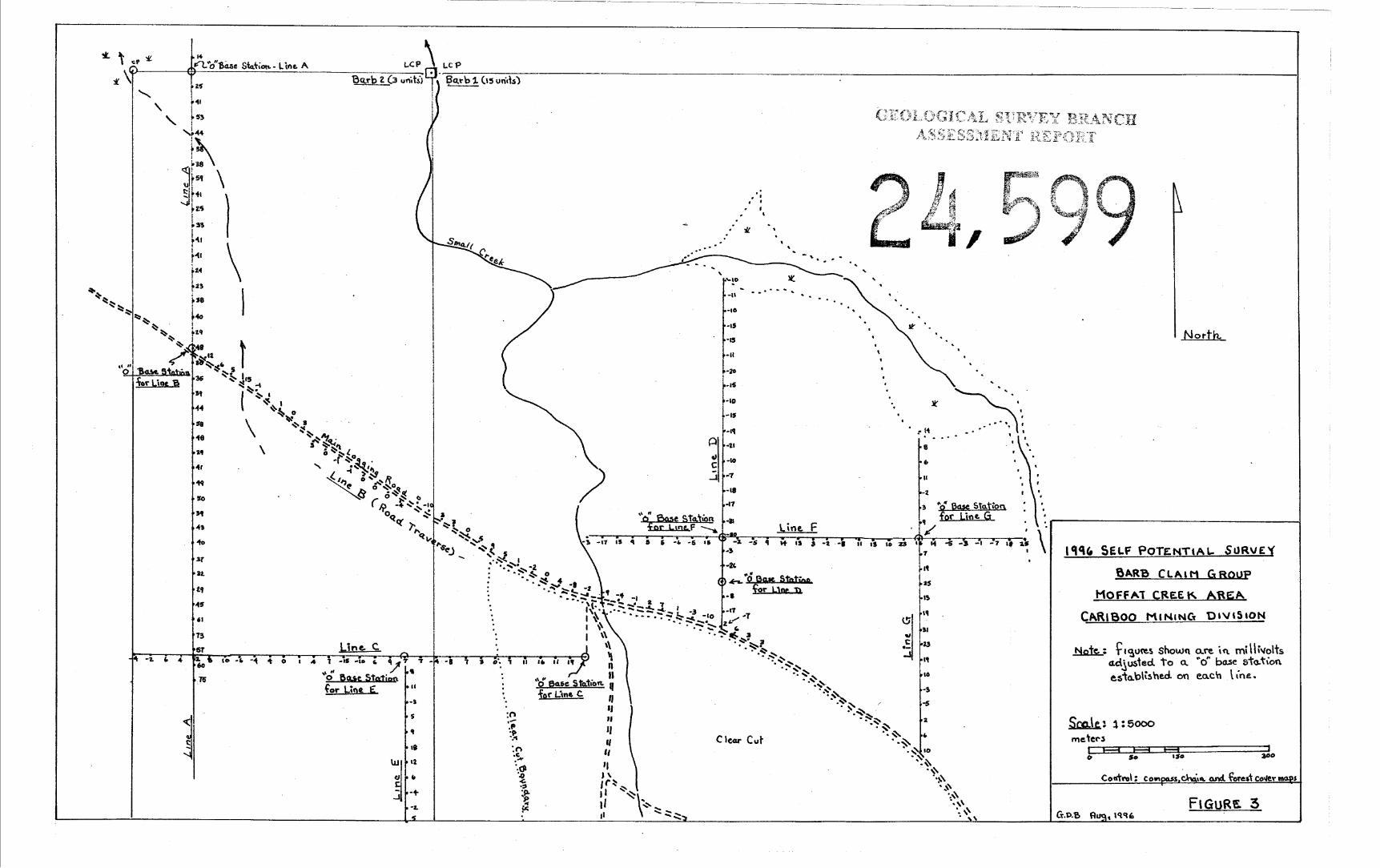
Figure 3 PLAN OF CONTOURED RESULTS
Figure 4 SELF POTENTIAL PROFILES
APPENDICES
A. LIST OF REFERENCES
B. STATEMENT OF QUALIFICATIONS
C. FIELD NOTES
(In Text)
(In Text)
(In Pocket)
(In Pocket)

I 15' I
Sca\e 1:
F I G U R E 1
L O C A T I O N MAP
B A R B G R O U P CARIB 00 MINING
I25,OOO 6 0 6 IO
I I I 10 6 0 d 10
H H H I I I 4
- Div.
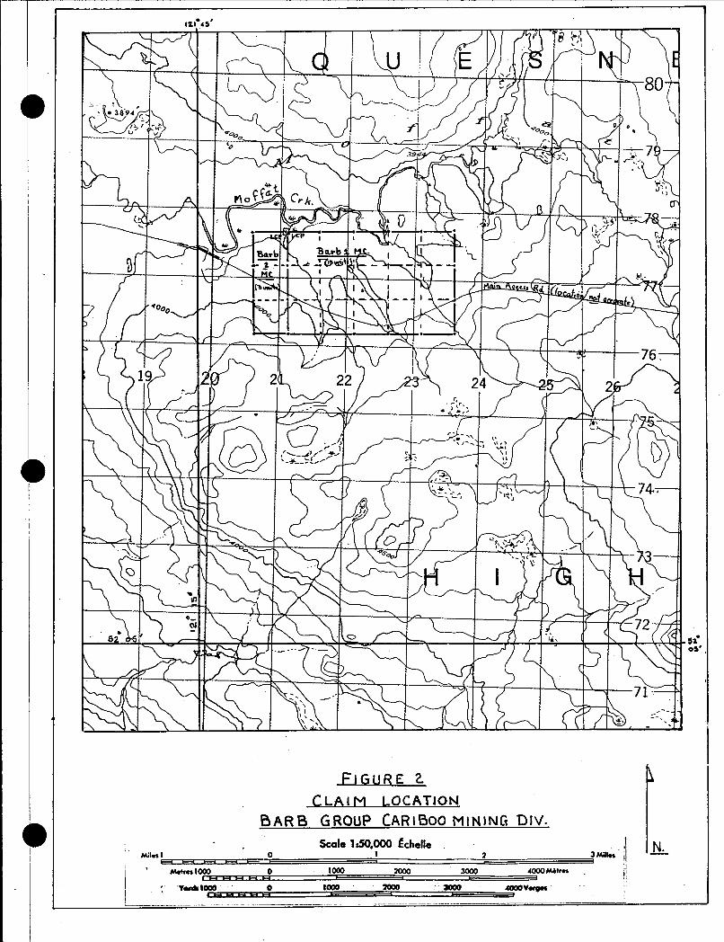
s i OS'

3
1 .O INTRODUCTION
The Barb Mineral Claim Group is a copper-molybdenum porphyry prospect located in
the Moffat Creek area about 26 km southeast of Horsefly, BC. Access to the property is
provided by all-weather gravel roads from either Horsefly, Spokin Lake, or 150-Mile House which
link up with a major logging road extending along the south side of Moffat Creek to the claims
(Figure 1).
The Barb claims cover part of a property staked in the early 1970s as the Tri Claim
Group for Green Land Mining Ltd. of Vancouver, BC. Subsequent exploration work included a 24
line-mile 1.P. survey in 1971, and a limited geochemical soil survey in 1972 (see references). An
I.P. anomaly outlined by this work and random occurrences of chalcopyrite-bearing float have
been the chief focus of exploration activity within the Barb claims to date.
The major obstacles to effective surface exploration within the general area have been
an almost total lack of bedrock exposure, deep overburden conditions, and near surface perched
water tables. These conditions would effectively mute most shallow geophysical or geochemical
expressions of sulfide mineralization. By necessity, the 1996 Self Potential Survey has been of a
reconnaissance nature aimed at exploring those areas considered to be better drained and
closer to bedrock than the norm.
The primary objective of the survey has been to explore inferred projections of the I.P.
anomaly outlined in 1971. A total 4900 m of line was completed during the period July 14 - 18,
1996.
2.0 TOPOGRAPHY AND SURFlClAL GEOLOGY
The Barb claims lie along the south side of a broad swampy valley drained by Moffat
Creek. Most of the terrain is essentially flat or gently rolling (Figure 2). Relief within the property
ranges from about 1184 m (3900 - feet) near the creek to a little over 1250 m (4100 - feet)
-1nnn aiui t ,he southern side of the valley.

4
A sandy till consisting of large boulders and cobbles intermixed with unsorted sand, 0 gravel and silt covers a broad area of the valley and appears to be of regional extent. Along
some stream cuts, the sandy till can be seen to overlie a tough compact boulder clay which is
considered to directly over!ie the bedrock throughout most of the district. The total thickness of
overburden is not known but a resistivity survey completed by the writer suggests it exceeds 15
m within most of the claim area. An unusual feature of the Moffat Creek valley is the presence
of standing water within 0.5 m or less of the surface. Much of the forest floor consists of thick
wet moss and shal!ow water filled depressions separated by sluggish stream courses and
swamps lined by alder growths.
3.0 GEOLOGY
The claims are situated near the northern edge of the Takomkane Batholith. To date, no
bedrock exposures have been found on the property but outcrops of coarse grained porphyritic
quartz monzonite, fine grained leucocratic granite and granite pegmatite occur along a
prominent hill about 3 km to the southeast.
4.0 MINERAL CLAIMS
a
The location of the Barb Group is shown in Figure 2. Claim details are as follows:
Tenure No. Barb 1 (15 units) 337855
Date Staked July 23. 1995
Barb 2 (03 units] 3391 27 August 20, 1995
Both claims are owned by G. D. Bvsouth of Boswell, BC.
5.0 SELF POTENTIAL SURVEY
5.1 THE SELF POTENTIAL EFFECT
Electrically conductive bodies of sulfide mineralization or graphite that lie well above and
below the water table commonly display large spontaneous ground potentials significantly above
background levels. Common amplitudes for sulfide mineralization range between 100 to 300
millivolts and may extend up to one volt foi graphite bodies. However, over areas of near surface

5
water table conditions, or over areas of thick clay cover, the spontaneous potential, or self
potential effect is considerably muted and may not be easily differentiated from normal
background potentials, which can reach amplitudes of 100 millivolts. Unlike other geophysical
methods, the self potential method is particularly sensitive to near surface conductors and can
often be used to define trenching targets; this, and its low cost, makes the self potential method
ideal for prospecting applications.
5.2 EQUIPMENT AND FIELD PROCEDURE
The self potential equipment used in this survey consisted of two nonpolarizing
electrodes, a reel of wire, and a multimeter. The electrodes were essentially pots fitted with a
base of unglazed porcelain and filled with saturated copper sulfate solution. Rubber plugs were
used to hold a copper rod in contact with the solution and form a leak-proof top. About 300 m
of No. 18 stranded copper wire was used on a large reel fitted with a commutator. A LCD
Micronta Digital Multimeter, having a 10 mega ohm impedance, was attached to the reel in a
protective compartment.
Field methods followed standard procedures except the wire was anchored at the base
station and the multimeter moved forward along the line with the reel. This allowed the operator
to observe each station along the line at the time readings were taken and make necessary
adjustments if necessary. Stations were established at 25 m intervals along all lines. Control
was by hip chain and compass. In all stations an attempt was made to establish stable ground
contact by digging through the humus and roots to damp soil, usually at the B-horizon.
Readings at all stations were made relative (corrected) to a primary base station which was set
at zero millivolts on each line (see field notes). The S. P. system was connected so that the
forward pot would be positive and any mineralizing potentials encountered would be negative.
Pot differences were checked at regular intervals.

6
5.3 RESULTS AND INTERPRETATION
A plan of the results with station locations is provided in Figure 3. Profiles are provided
in Figure 4. All results shown have been corrected to a zero base station established on each
line.
The profiles provide the best illustration of the survey results. The largest ground
potentials were measured along Line A and all were positive due to the location of the base
station over an area of lowest potential. Potential differences between the base station and
stations immediately to the north show a rapid increase, reaching 53 millivolts at station 75 S,
which is above normal background levels expected for this environment, but is not of sufficient
magnitude to constitute a definite self potential anomaly. The base station was situated in a
transition zone between a prevailing swampy creek environment to the north and dry open
jackpine environment to the south which may have caused the increased background potentials.
However, further testing is required with short lines west and east of the base station to
determine whether or not the negative low is part of the normal environment or is in fact, a self
potential anomaly. Other potentials measured along Line A are within the range of normal
background deterrminations.
Line B, which was run along the main road, showed a remarkable lack of background
variation. This can be attributed to an absence of vegetation in the vicinity of the electrodes and
to the uniformity of the road materials in both acidity and moisture content.
Potentials measured along the other lines plotted out on the profiles mainly as low
undulating curves with amplitudes not exceeding 35 millivolts. This is considered to be fairly
normal for water saturated forested ground of low relief.

7
6.0 STATEMENT OF EXPENDITURES
SELF POTENTIAL SURVEY --- BARB CLAIM GROUP, 1996
1. Field Work
G. D. Bysouth
July 14
July 15
July 17
July 18
Total
6. J. Bysouth
July 14
July 15
July 17
July 18
Total
08 h r s
08 hrs
08 hrs
08 hrs
32 hours @ $30/hr .......................................... $960.00
08 hrs
08 h r s
08 hrs
08 hrs
32 hours @ $14/hr ........................................... $ 448.00
2. Report Preparation
G. D. Bysouth 10 hours @ $30/hr ........................................... $ 300.00
3. Vehicle Costs
1979 4 x 4 4 days @ $25/day ........................................... $ 100.00
4. Equipment and Supplies ............................................................................. $ 50.00
TOTAL COST OF SURVEY ............................. $1858.00

8
7.0 CONCLUSIONS
Except for a negative low established at the base station of Line A, all other potentials
measured in the survey area are within normal background levels. However, the lack of self
potential anomalies does not preclude the existence of sulfide mineralization within the area.
That is, the prevailing water saturated nature of the ground tested greatly hinders the
effectiveness of the self potential method, and therefore, only positive results should be
considered significant.
The negative low at the base station of Line A should be dlineated by short lines to the
west and east. Other than this, further self potential work is not feasible.
Garry D. Bysouth
Geologist

9
APPENDIX A
LIST OF REFERENCES
1. Assessment Reports 3068,3069 and 3876
2. BC Dept. of Mines and Pet, Res. GEM 1971, p 129
GEM 1972, p 330

10
APPENDIX B
STATEMENT OF QUALIFICATIONS
I , Garry D. Bysouth, of Boswell, British Columbia do certify that:
1. I am a geologist
2. I am a graduate of the University of British Columbia, with a BSc in
Geology in 1966
3. From 1966 to the present I have been engaged in mining and exploration
geology in British Columbia
4. I have used the self potential method in mineral exploration from 1980
to the present
5. I personally was involved in the field work contained in this report and
interpreted the results
I Garry D. Bysouth

11
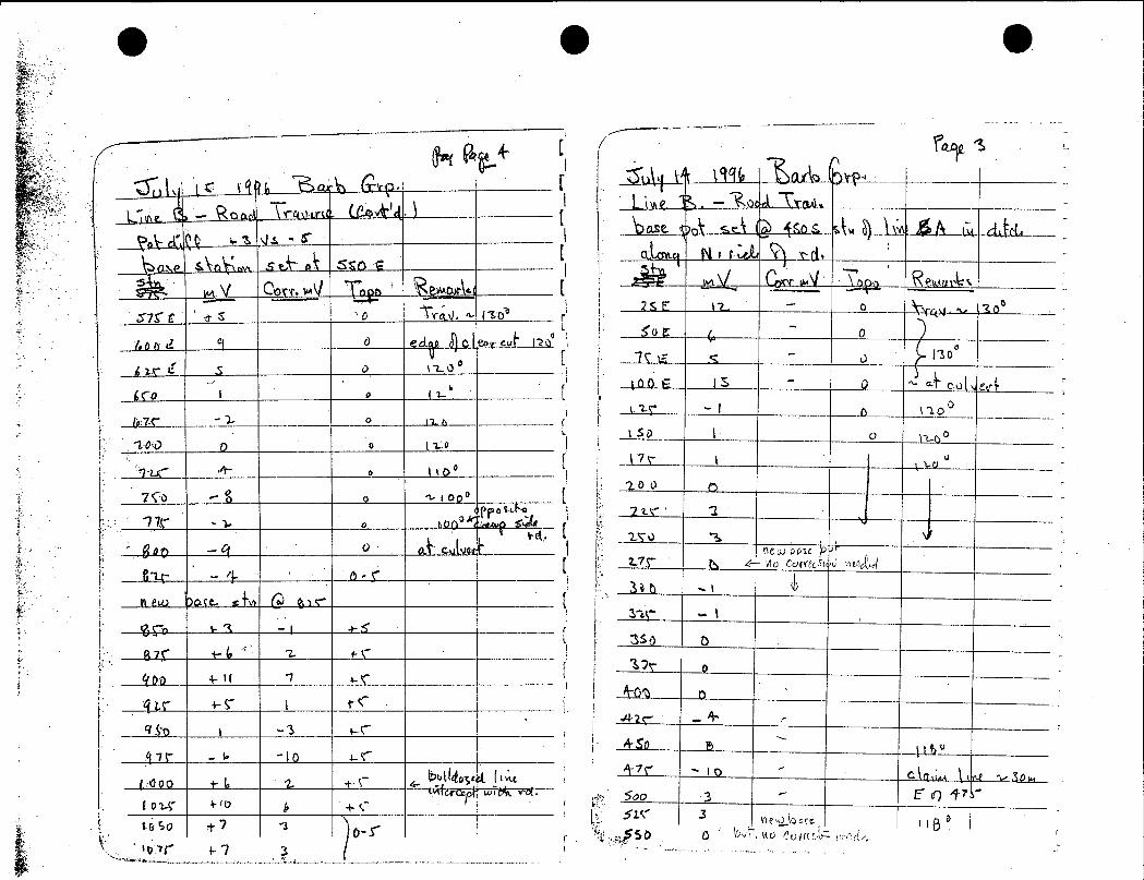
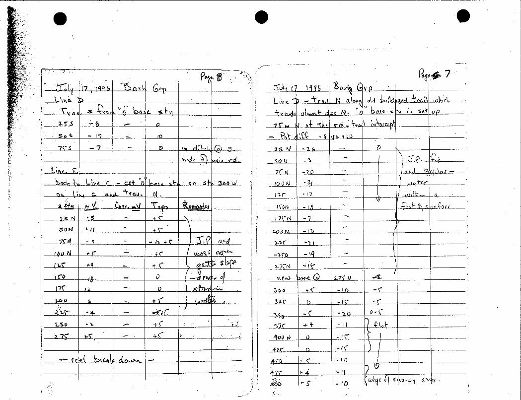
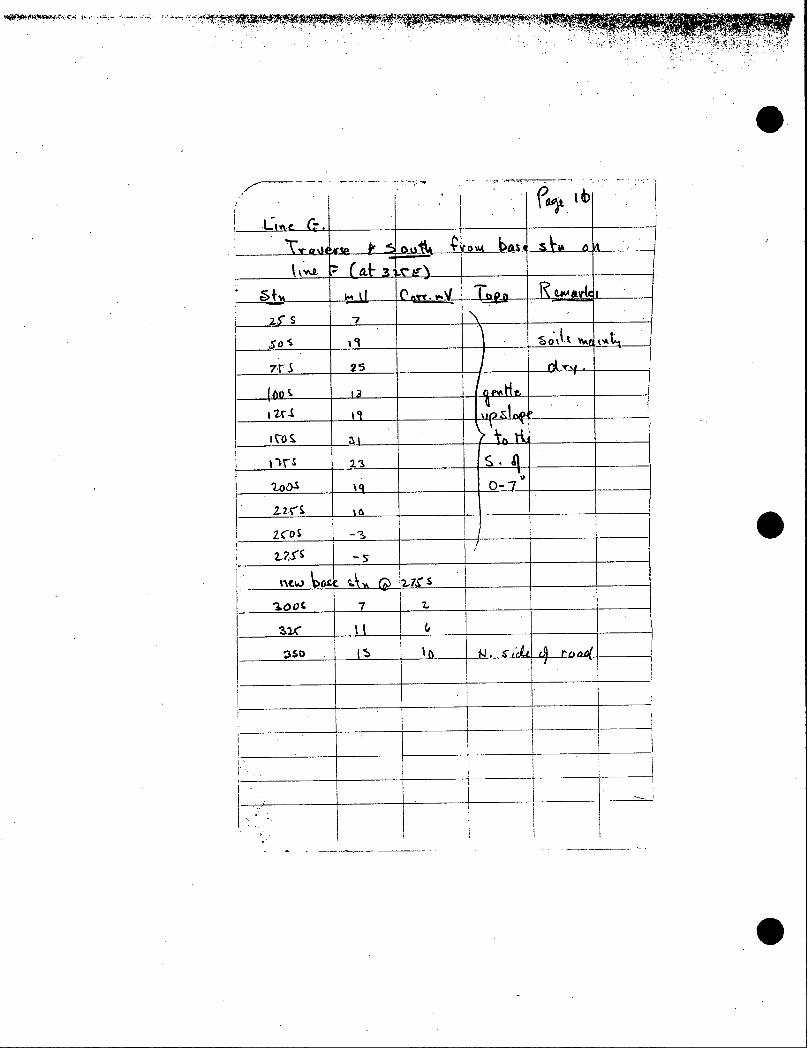
APPENDIX C
FIELD NOTES

...
... 5
.:
.
..
..
..
.
,_
:-
IF
=-
,&
-
..
..
..
.
.............. ...........
. ......
..
.. -
\ .__I-
__
.......... ---_
- --
........... -
-
__
.,
..
:
+
.,
.
..
.
.
..
. .
.
..
: I'
..
..
,...._. .
.
. .
._, ..::.
., .. L1.
. . .
. , ...
,
._
. .
1-__
, .
,,
.
.... .
. l.. .. .
. . .
..
. .
:,
v
, .
, :=.?..*.,~
~

I i
M
i c 1
L . -
J
D
17
7
A.
t .- J a I P
ul t/ r
&t t- 4
- .. .
..
.:
. .
.
...
.- ,

'I: ! ! I
I
1 I _-
..
I.
.
.
. . .,
a
e
i I
I I I
I ~ i I