Embed Size (px)
Citation preview
1
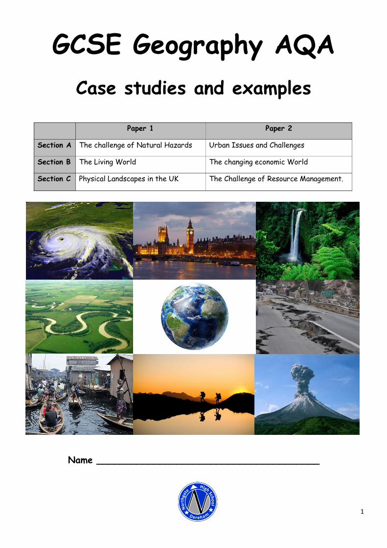
GCSE Geography AQA
Case studies and examples
Name _______________________________________
Paper 1 Paper 2
Section A The challenge of Natural Hazards Urban Issues and Challenges
Section B The Living World The changing economic World
Section C Physical Landscapes in the UK The Challenge of Resource Management.
2
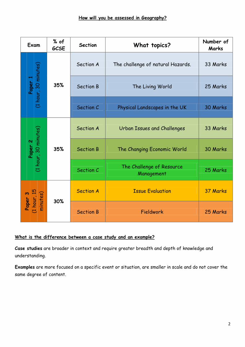
How will you be assessed in Geography?
Exam % of
GCSE Section What topics?
Number of
Marks
Pape
r 1
(1 h
our,
30
min
utes)
35%
Section A The challenge of natural Hazards. 33 Marks
Section B
The Living World 25 Marks
Section C
Physical Landscapes in the UK 30 Marks
Pape
r 2
(1 h
our,
30
min
utes)
35%
Section A
Urban Issues and Challenges 33 Marks
Section B
The Changing Economic World 30 Marks
Section C
The Challenge of Resource
Management 25 Marks
Pape
r 3
(1 h
our,
15
min
utes)
30%
Section A
Issue Evaluation 37 Marks
Section B
Fieldwork 25 Marks
What is the difference between a case study and an example?
Case studies are broader in context and require greater breadth and depth of knowledge and
understanding.
Examples are more focused on a specific event or situation, are smaller in scale and do not cover the
same degree of content.

3
Command words in Geography
In Geography you will have to answer a variety of questions to assess your understanding on a variety
of topics. In order to answer these questions well you need to make sure you know what the question
is asking you to do. To do this you need to know what all the following command words mean:
Command
word
What does it mean?
Assess
Make an informed judgement. For example, ‘Assess how effective your presentation technique(s)
were in representing the data collected in this enquiry’.
Calculate Work out the value of something.
For example, 'Using Figure 7, calculate the increase in retail sales value of Fairtrade bananas
between 2000 and 2012'.
Compare Identify similarities and differences.
For example, 'Using Figure 4, compare HDI values in Africa and South America'.
Complete Finish the task by adding given information.
For example, 'Complete the following sentences: The greatest number of category four tropical
storms happen in the ……………………. Ocean. Apart from very strong winds, one other associated
weather feature of a category four storm is…………………………'
Describe Set out characteristics. For example, 'Using Figure 9, describe the distribution of areas with
existing licenses for fracking in the UK'.
Discuss Present key points about different ideas or strengths and weaknesses of an idea.
For example, 'Discuss the effects of urban sprawl on people and the environment. Use Figure 3
and a case study of a major city in the UK'.
Evaluate Judge from available evidence. Use advantages and disadvantages and weigh up.
For example, 'Evaluate the effectiveness of an urban transport scheme(s) you have studied.
Explain Set out purposes or reasons. For example, 'Using Figure 12 and your own knowledge, explain how
different landforms may be created by the transport and deposition of sediment along the coast'
Give Produce an answer from recall. For example, 'Give one condition that is needed for a tropical
storm to form' (Specimen Paper 1, qu. 01.6).
Identify Name or otherwise characterise.
For example, 'Identify the glacial landform at grid reference 653532' (Specimen Paper 1, qu.
05.1).
Justify Support a case with evidence.
For example, 'Transnational corporations (TNCs) only bring advantages to the host country.' Do
you agree with this statement? Justify your decision. (Specimen Paper 2, qu. 02.10)
Express in clear terms.
Outline Set out main characteristics.
For example, 'Outline one way that Fairtrade helps to deal with the problems of unequal
development'.
State For example, 'State one characteristic of the course of the River Ouse in grid square 5754'
Suggest Present a possible case.
For example, 'Suggest how the sea defences shown in Figure 11 help to protect the coastline'
To what
extent
Judge the importance or success of (strategy, scheme, project).
For example, 'To what extent do urban areas in lower income countries (LICs) or newly emerging
economies (NEEs) provide social and economic opportunities for people?'
Use
evidence to
support this
statement
To select and present information to prove or disprove something.
For example, 'Weather in the UK is becoming more extreme.' Use evidence to support this
statement.
4
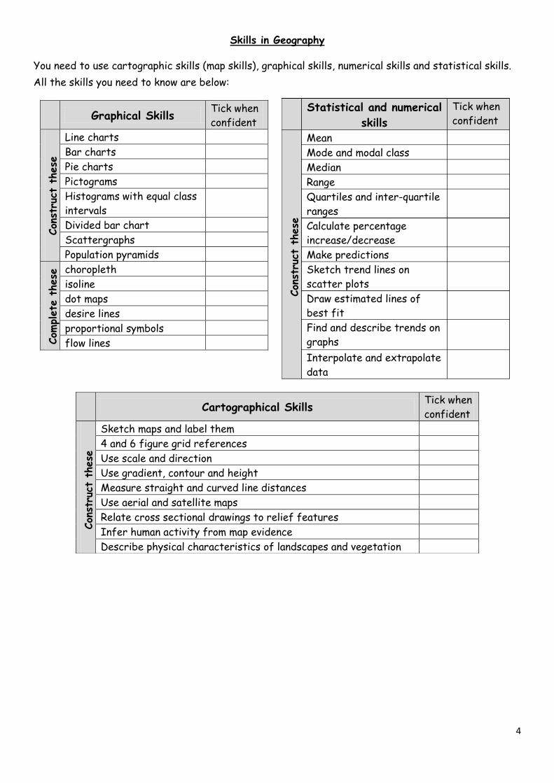
Skills in Geography
You need to use cartographic skills (map skills), graphical skills, numerical skills and statistical skills.
All the skills you need to know are below:
Graphical Skills Tick when
confident
Con
stru
ct t
hese
Line charts
Bar charts
Pie charts
Pictograms
Histograms with equal class
intervals
Divided bar chart
Scattergraphs
Population pyramids
Com
plete
these
choropleth
isoline
dot maps
desire lines
proportional symbols
flow lines
Cartographical Skills Tick when
confident
Con
stru
ct t
hese
Sketch maps and label them
4 and 6 figure grid references
Use scale and direction
Use gradient, contour and height
Measure straight and curved line distances
Use aerial and satellite maps
Relate cross sectional drawings to relief features
Infer human activity from map evidence
Describe physical characteristics of landscapes and vegetation
Statistical and numerical
skills
Tick when
confident
Con
stru
ct t
hese
Com
plete
these
Mean
Mode and modal class
Median
Range
Quartiles and inter-quartile
ranges
Calculate percentage
increase/decrease
Make predictions
Sketch trend lines on
scatter plots
Draw estimated lines of
best fit
Find and describe trends on
graphs
Interpolate and extrapolate
data
5
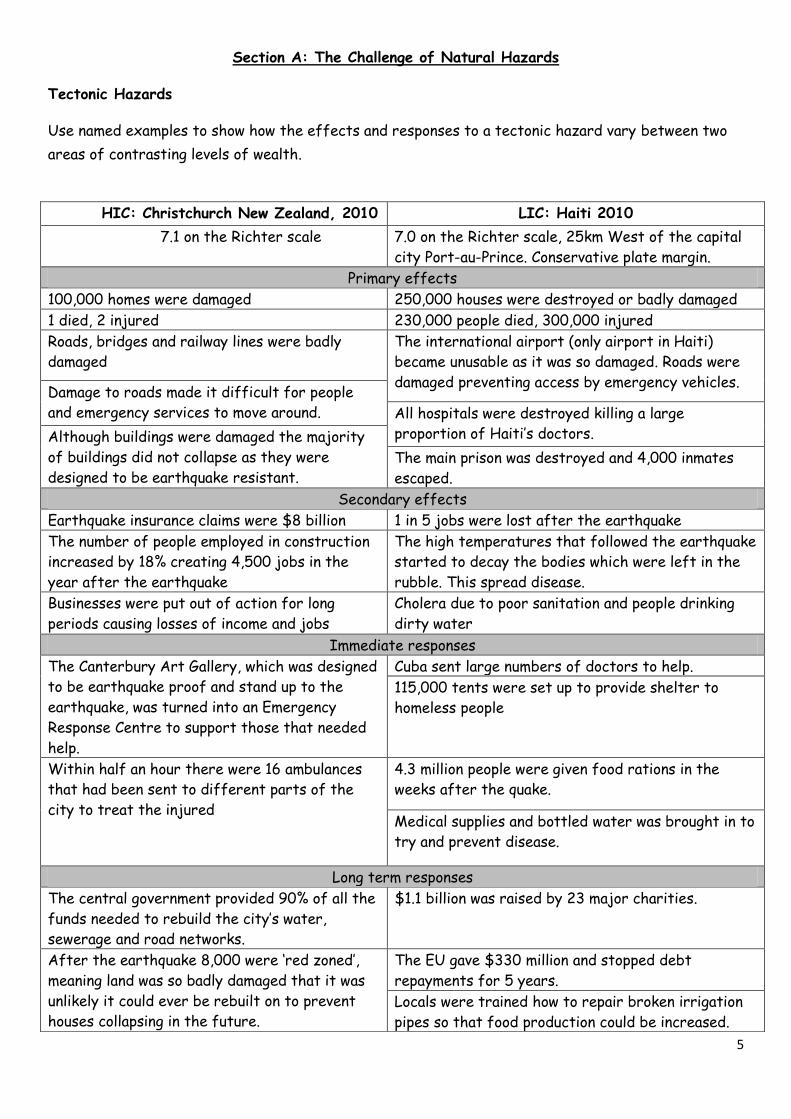
Section A: The Challenge of Natural Hazards
Tectonic Hazards
Use named examples to show how the effects and responses to a tectonic hazard vary between two
areas of contrasting levels of wealth.
HIC: Christchurch New Zealand, 2010 LIC: Haiti 2010
7.1 on the Richter scale 7.0 on the Richter scale, 25km West of the capital
city Port-au-Prince. Conservative plate margin.
Primary effects
100,000 homes were damaged 250,000 houses were destroyed or badly damaged
1 died, 2 injured 230,000 people died, 300,000 injured
Roads, bridges and railway lines were badly
damaged
The international airport (only airport in Haiti)
became unusable as it was so damaged. Roads were
damaged preventing access by emergency vehicles. Damage to roads made it difficult for people
and emergency services to move around. All hospitals were destroyed killing a large
proportion of Haiti’s doctors. Although buildings were damaged the majority
of buildings did not collapse as they were
designed to be earthquake resistant. The main prison was destroyed and 4,000 inmates
escaped.
Secondary effects
Earthquake insurance claims were $8 billion 1 in 5 jobs were lost after the earthquake
The number of people employed in construction
increased by 18% creating 4,500 jobs in the
year after the earthquake
The high temperatures that followed the earthquake
started to decay the bodies which were left in the
rubble. This spread disease.
Businesses were put out of action for long
periods causing losses of income and jobs
Cholera due to poor sanitation and people drinking
dirty water
Immediate responses
The Canterbury Art Gallery, which was designed
to be earthquake proof and stand up to the
earthquake, was turned into an Emergency
Response Centre to support those that needed
help.
Cuba sent large numbers of doctors to help.
115,000 tents were set up to provide shelter to
homeless people
Within half an hour there were 16 ambulances
that had been sent to different parts of the
city to treat the injured
4.3 million people were given food rations in the
weeks after the quake.
Medical supplies and bottled water was brought in to
try and prevent disease.
Long term responses
The central government provided 90% of all the
funds needed to rebuild the city’s water,
sewerage and road networks.
$1.1 billion was raised by 23 major charities.
After the earthquake 8,000 were ‘red zoned’,
meaning land was so badly damaged that it was
unlikely it could ever be rebuilt on to prevent
houses collapsing in the future.
The EU gave $330 million and stopped debt
repayments for 5 years.
Locals were trained how to repair broken irrigation
pipes so that food production could be increased.
6
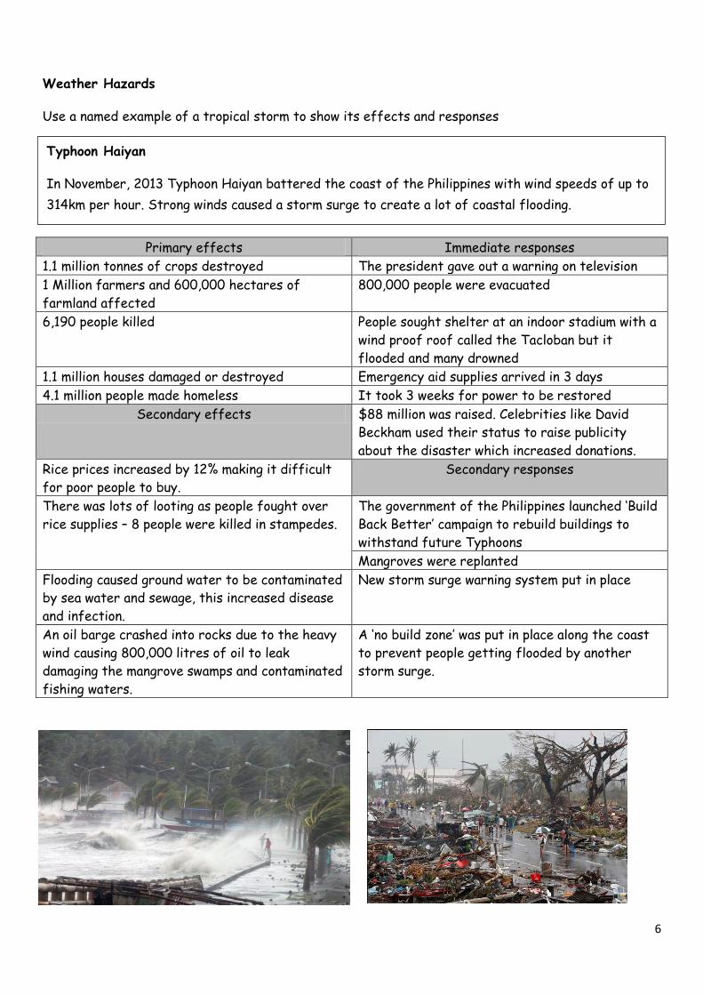
Weather Hazards
Use a named example of a tropical storm to show its effects and responses
Primary effects Immediate responses
1.1 million tonnes of crops destroyed The president gave out a warning on television
1 Million farmers and 600,000 hectares of
farmland affected
800,000 people were evacuated
6,190 people killed People sought shelter at an indoor stadium with a
wind proof roof called the Tacloban but it
flooded and many drowned
1.1 million houses damaged or destroyed Emergency aid supplies arrived in 3 days
4.1 million people made homeless It took 3 weeks for power to be restored
Secondary effects $88 million was raised. Celebrities like David
Beckham used their status to raise publicity
about the disaster which increased donations.
Rice prices increased by 12% making it difficult
for poor people to buy.
Secondary responses
There was lots of looting as people fought over
rice supplies – 8 people were killed in stampedes.
The government of the Philippines launched ‘Build
Back Better’ campaign to rebuild buildings to
withstand future Typhoons
Mangroves were replanted
Flooding caused ground water to be contaminated
by sea water and sewage, this increased disease
and infection.
New storm surge warning system put in place
An oil barge crashed into rocks due to the heavy
wind causing 800,000 litres of oil to leak
damaging the mangrove swamps and contaminated
fishing waters.
A ‘no build zone’ was put in place along the coast
to prevent people getting flooded by another
storm surge.
Typhoon Haiyan
In November, 2013 Typhoon Haiyan battered the coast of the Philippines with wind speeds of up to
314km per hour. Strong winds caused a storm surge to create a lot of coastal flooding.
7
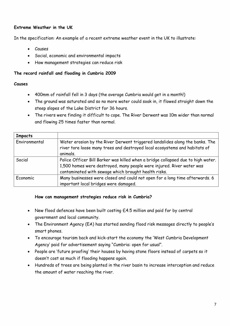
Extreme Weather in the UK
In the specification: An example of a recent extreme weather event in the UK to illustrate:
Causes
Social, economic and environmental impacts
How management strategies can reduce risk
The record rainfall and flooding in Cumbria 2009
Causes
400mm of rainfall fell in 3 days (the average Cumbria would get in a month!)
The ground was saturated and so no more water could soak in, it flowed straight down the
steep slopes of the Lake District for 36 hours.
The rivers were finding it difficult to cope. The River Derwent was 10m wider than normal
and flowing 25 times faster than normal.
Impacts
Environmental Water erosion by the River Derwent triggered landslides along the banks. The
river tore loose many trees and destroyed local ecosystems and habitats of
animals.
Social Police Officer Bill Barker was killed when a bridge collapsed due to high water.
1,500 homes were destroyed, many people were injured. River water was
contaminated with sewage which brought health risks.
Economic Many businesses were closed and could not open for a long time afterwards. 6
important local bridges were damaged.
How can management strategies reduce risk in Cumbria?
New flood defences have been built costing £4.5 million and paid for by central
government and local community.
The Environment Agency (EA) has started sending flood risk messages directly to people’s
smart phones.
To encourage tourism back and kick-start the economy the ‘West Cumbria Development
Agency’ paid for advertisement saying “Cumbria: open for usual”.
People are ‘future proofing’ their houses by having stone floors instead of carpets so it
doesn’t cost as much if flooding happens again.
Hundreds of trees are being planted in the river basin to increase interception and reduce
the amount of water reaching the river.
8
Test yourself
1. Where is the location of your HIC earthquake case study?
2. What year was the Earthquake in Gorkha Nepal?
3. Give 3 primary effects of the Gorkha Nepal earthquake.
4. Give 3 primary effects of the HIC earthquake.
5. How many tourists died from the avalanche on Mt Everest caused by the earthquake.
6. How much did the HIC earthquake and the LIC earthquake cost?
7. How many million dollars were raised to provide the people of Gorkha with emergency food and
shelter?
8. The Red Cross provided shelter for how many million people in Gorkha?
9. A landslide was a mud flow was caused by a broken water pipe in which town?
10. What year did Typhoon Haiyan happen?
11. Give three primary effects of Typhoon Haiyan.
12. How many weeks did the Philippines not have power for?
13. Give three secondary responses of Typhoon Haiyan?
14. What happened to the oil barge?
15. How many people were made homeless?
16. How many people were killed in Typhoon Haiyan?
17. In the UK, Cumbria flooded in 2009. How many mm of precipitation fell in how many days?
18. Give three management strategies to try and reduce the flood risk in Cumbria.
19. Give two social impacts of the Cumbria floods.
20. What was the name of the river that flooded in Cumbria?
The challenge of natural Hazards possible questions- could you answer them?
Remember to PEEL for 6/9 markers. Point, evidence, explanation, link back to the question.
Suggest reasons why people continue to live in areas at risk from a tectonic hazard. [4 Marks]
Evaluate how monitoring, prediction, protection and planning can reduce the effects of tropical storms. [9
Marks]
Using a named case study of a tropical storm assess the primary and secondary effects of the storm. [6 Marks]
Using a named case study of a tropical storm assess the immediate and long term responses to the storm. [9
Marks]
Discuss the evidence for climate change from the beginning of the last age to the present day. [6 Marks]
Discuss the effects of climate change on people and the environment. [6 Marks]
Outline the evidence which suggests that weather is becoming more extreme in the UK. [4 Marks]
Using an example of a recent extreme weather event in the UK discuss the social, economic and environmental
impacts it had on the UK. [6 marks]
In reference to a recent extreme weather event in the UK outline how management strategies can reduce risk.
[4 marks]
To what extent can mitigation and adaptation can manage the effects of climate change [6 Marks]
9
Section B: The Living world
Local ecosystem
In the specification: “An example of a small scale UK ecosystem to illustrate the concept of
interrelationships within a natural system, an understanding of producers, consumers, decomposers,
food chain, food web and nutrient cycling”.
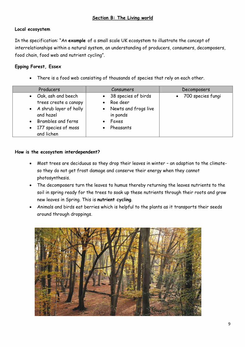
Epping Forest, Essex
There is a food web consisting of thousands of species that rely on each other.
Producers Consumers Decomposers
Oak, ash and beech
trees create a canopy
A shrub layer of holly
and hazel
Brambles and ferns
177 species of moss
and lichen
38 species of birds
Roe deer
Newts and frogs live
in ponds
Foxes
Pheasants
700 species fungi
How is the ecosystem interdependent?
Most trees are deciduous so they drop their leaves in winter – an adaption to the climate-
so they do not get frost damage and conserve their energy when they cannot
photosynthesis.
The decomposers turn the leaves to humus thereby returning the leaves nutrients to the
soil in spring ready for the trees to soak up these nutrients through their roots and grow
new leaves in Spring. This is nutrient cycling.
Animals and birds eat berries which is helpful to the plants as it transports their seeds
around through droppings.
10
The Tropical Rainforest
In the specification: A case study of a tropical rainforest to illustrate:
Causes of deforestation – subsistence and commercial farming, logging, road building,
mineral extraction, energy development, settlement, population growth
Impacts of deforestation – economic development, soil erosion, contribution to climate
change.
The Amazon Rainforest – causes of deforestation
Causes of deforestation
Resource exploiting activities
Logging Timber companies come into to log trees like mahogany and teak to sell them to
make money. They clear all the other trees out of the way to get to these trees.
Mineral
extraction
There are 50,000 hectares of land being used for gold mining. All the trees are
cleared in this area and the mines release chemicals which get onto the Amazon
River. Carajas iron ore mine in Brazil is the world’s biggest.
Energy
Development
150 dams have been built in the river to provide Hydro Electric Power (HEP) such
as the Belo Monte scheme, which flood vast areas of rainforest. Brazil get 85% of
their energy from these dams.
Illegal trade
in wildlife
Hunting, poaching and trafficking in wildlife is big business. The Golden headed lion
tamarind and the jaguar are killed for their fur. Baby sloths are sold as pets.
What activities are causing the forest to be cleared?
Commercial
farming -
cattle
Much of the rainforest has been cleared for livestock rearing – cattle for beef.
This accounts for 80% of clearing the rainforest. However the land cannot be used
for long as the soil quality rapidly declines and with it the grass and so more forest
has to be cleared.
The forest is cleared to grow plantations of bananas and palm oil. In the Amazon
they are growing sugar cane as a biofuel to fuel the growing number of cars in
Brazil.
Subsistence
farming
Local native people have been using the rainforest for 1000’s of years. They have
been clearing small patches of land to grow crops. This is sustainable as these
people are part of the ecosystem here. Forests also get chance to regrow.
Road
building
The Trans-Amazonian highway was built to start connecting cities and make travel
easier in Brazil – this opened up huge areas of the rainforest which were previously
remote and safe from loggers.
Settlement
and
population
growth
As Brazil’s population boomed everyone needed a place to live and a job. The
government gave many people an area of rainforest that they could farm to
release pressure on the cities. This caused a lot deforestation through ‘slash and
burn’ farming. Population in Manaus is now over 2 million.
Many of the world’s rainforests are in LICs of NEEs. They want to develop and often owe money
to HICs to get richer and pay back their debts. The easiest way to do this is to exploit their
resources – their rainforests.

11
The Amazon Rainforest - Impacts of deforestation
Impacts of deforestation – economic development, soil erosion, contribution to climate change.
Impacts of deforestation
Global warming The canopy of trees absorbs huge amounts of Carbon Dioxide (making it a
Carbon sink) from the atmosphere. The more trees that are felled, the more
Carbon Dioxide there is in the atmosphere. Also fire is often used to clear the
rainforest which releases more CO2. This makes it one of the major
contributors to global warming and climate change.
Loss of
biodiversity
The number of species will be reduced and endemic species will become extinct.
In the Amazon 38 species are now extinct due to shrinking habitats.
Disruption to
the water cycle
When trees are felled evapotranspiration is reduced which reduces the amount
of moisture in the atmosphere and therefore reduces rainfall. The lack of
rainfall makes the climate warmer and drier which changes the climate.
Soil erosion and
fertility
The canopy acts as protection for the soil from the heavy rain. As soon as it is
removed the heavy rain soon washes away the thin layer of fertile topsoil. Once
this happens nothing will be able to grow - the eroded soil also silts up rivers.
River pollution Mercury is used in mining gold. This is washed into rivers and poisons the fish.
Decline of
indigenous
tribes
There are only 240 tribes in the Amazon left. Many have been forced out of
their homes to make way for large dam, mining or road projects. Most displaced
people end up in cities. These people have lost their culture and heritage and
addiction to alcohol or drugs is common. Their knowledge is also lost. Luckily
they have recently been given more rights and there are still 1 million people
living in the Amazon.
12
Hot deserts
In the specification: A case study of a hot desert to illustrate:
Development opportunities in hot desert environments: mineral extraction, energy,
farming, tourism
Challenges of developing hot desert environments: extreme temperatures, water supply,
inaccessibility.
The Western Desert, USA
Challenges of developing hot desert environments: extreme temperatures, water supply,
inaccessibility.
Development Opportunities
Farming - In the rural areas of the Western Desert people make their money from agriculture.
The warm temperatures and sunlight are good for growing but water is an issue. Therefore
irrigation is important. Agriculture makes up 10% of the economy.
Aquifers Large stores of water are found beneath the desert. Wells are dug and water
brought up from aquifers to irrigate crops. Farming in California’s Coachella
Valley grow lush crops such as lemons, peppers and grapes (which get made into
wine – California is famous for it’s wine).
Canals Canals take water from the reservoir behind the Glen Canyon dam on the
Colorado River to provide irrigation for large scale agriculture. Farmers are
allocated 80% of the water from the Colorado River.
Mineral
extraction
The Western Desert is rich in minerals like copper, uranium, lead, zinc and coal.
Not all of these minerals have been exploited because they think it will cause
conflict with local farmers. Copper mining has taken place in the Sonoran
Desert near Ajo, Arizona. Open cast mining takes place on a large scale here.
Energy - solar The Sonoran Solar Project in Arizona is a new solar power plant project that
will produce energy for 100,000 homes. Jobs will also be created in
construction on this project.
Energy -
Hydroelectric
HEP made from water from Lake Mead behind the Hoover Dam. Jobs are also
created in Dam maintenance.
Tourism The National Parks offer tourists the chance to see the Grand
Canyon and the Joshua Tree National Park.
Las Vegas attracts 37 million tourists per year.
People enjoy boating on Lake Mead.
The heritage of Native Americans are celebrated at the Colorado
Museum in Parker, Arizona.
The Western Desert
With temperatures of 50 Degrees Celsius in July and very little rainfall the Western Desert
has a very low carrying capacity. However with huge cities like Las Vegas people have to find
strategies to adapt to this harsh climate and make a living.
13
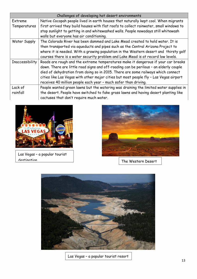
Challenges of developing hot desert environments
Extreme
Temperatures
Native Cocopah people lived in earth houses that naturally kept cool. When migrants
first arrived they build houses with flat roofs to collect rainwater, small windows to
stop sunlight to getting in and whitewashed walls. People nowadays still whitewash
walls but everyone has air conditioning.
Water Supply The Colorado River has been dammed and Lake Mead created to hold water. It is
then transported via aqueducts and pipes such as the Central Arizona Project to
where it is needed. With a growing population in the Western desert and thirsty golf
courses there is a water security problem and Lake Mead is at record low levels.
Inaccessibility Roads are rough and the extreme temperatures make it dangerous if your car breaks
down. There are little road signs and off-roading can be perilous – an elderly couple
died of dehydration from doing so in 2015. There are some railways which connect
cities like Las Vegas with other major cities but most people fly – Las Vegas airport
receives 40 million people each year – much safer than driving.
Lack of
rainfall
People wanted green lawns but the watering was draining the limited water supplies in
the desert. People have switched to fake grass lawns and having desert planting like
cactuses that don’t require much water.
Las Vegas – a popular tourist resort The Western Desert
Las Vegas – a popular tourist resort
Las Vegas – a popular tourist
destination. The Western Desert
14
Test yourself
1. Give two species of tree which is logged for timber in the Amazon Rainforest.
2. How many hectares of rainforest are being used for gold mining?
3. What type of energy development is the Amazon Rainforest being used for?
4. Brazil is deforesting the Amazon to make way for biofuels – what is the biofuel?
5. Why can deforestation add to global warming?
6. Gold mining is causing river pollution in the Amazon. Why?
7. How many tribes are in the Amazon?
8. How can deforestation lead to soil erosion in the Amazon?
9. What animal is farmed creating huge amounts of deforestation?
10. What is the name of the large road which was built through the Amazon rainforest to connect
major cities in Brazil?
11. In the Western Desert, USA what % does agriculture make up in the economy?
12. What are the large stores of water called beneath the desert?
13. Farmers are allocated 80% of the water from the Colorado River which is stored in a dam on
the Colorado River. What is the dam called?
14. Name three minerals or metals that are extracted and sold to make money.
15. What is the solar project called in Arizona?
16. How many visitors does Las Vegas have every year?
17. What is the Central Arizona project?
18. How is hydroelectric power (HEP) created in the Western desert?
19. Give two types of crops which are grown in the Western desert.
20. Give the location of open cast mining in the Western Desert.
The Living world possible questions- could you answer them?
Remember to PEEL for 6/9 markers. Point, evidence, explanation, link back to the question.
Assess the strategies used to manage the rainforest sustainably. [6 marks]
Assess the strategies used to reduce the risk of desertification. [6 marks]
Discuss the causes of deforestation in a named case study. [9 marks]
Evaluate the impacts of deforestation. [9 marks]
The value of tropical rainforests to people and the environment is enormous. To what extent do you
agree? [6 marks]
Assess the opportunities for development of a hot desert. [9 marks]
Assess the opportunities and challenges for development in the hot desert environment you have
studied. [9 marks]
Assess the human and physical causes of desertification. [9 marks]
Describe and explain the strategies used to reduce the risk of desertification. [6 marks]
15
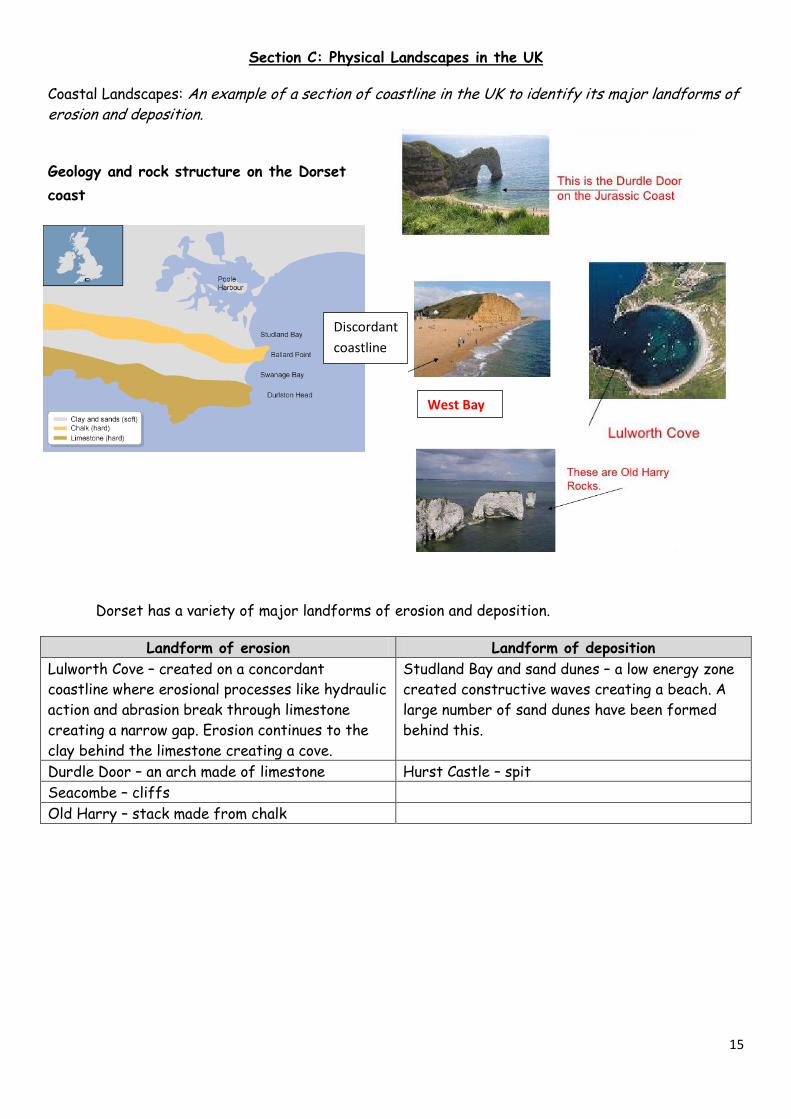
Section C: Physical Landscapes in the UK
Coastal Landscapes: An example of a section of coastline in the UK to identify its major landforms of erosion and deposition.
Geology and rock structure on the Dorset
coast
Dorset has a variety of major landforms of erosion and deposition.
Landform of erosion Landform of deposition
Lulworth Cove – created on a concordant
coastline where erosional processes like hydraulic
action and abrasion break through limestone
creating a narrow gap. Erosion continues to the
clay behind the limestone creating a cove.
Studland Bay and sand dunes – a low energy zone
created constructive waves creating a beach. A
large number of sand dunes have been formed
behind this.
Durdle Door – an arch made of limestone Hurst Castle – spit
Seacombe – cliffs
Old Harry – stack made from chalk
Discordant
coastline
Concordant
coastline
West Bay
Concordant coastline
Discordant
coastline
16
Coastal realignment in Medmerry
An example of a coastal management scheme in the UK to show:
the reasons for management
the management strategy
the resulting effects and conflicts
Reasons for management
The Environment Agency (EA) considered the area to be at risk from flooding. The only thing
protecting it was a shingle ridge and every year expensive (£200,000) beach reprofiling was having to
take place. This became unsustainable. If this area was breached 348 properties in Selsey would be
in danger along with a water treatment plant and a busy main road– it was last breached in 2008
costing £5 million.
The management strategy
A new embankment was created from clay from the area two km in land.
Behind the embankment they built a channel to drain excess water.
Rock armour was built against the embankment to offer more support – 60,000 tonnes of it
was imported from Norway.
Once the embankment was in place they made a 110m breach in the shingle bank to allow
the sea to flood the area, creating a salt marsh.
Positive effects Controversy and conflicts
Social Chances of flooding have been reduced
and so far has protected people’s homes.
There has been a new footpath and
cycle path built making it a nice area for
people to live.
Some locals think the EA should not have
given up land to the sea so quickly and
should have carried on protecting it.
Some people believe that this was a lot of
money to spend in one area – money better
spent elsewhere.
Economic Tourism is increasing especially
birdwatchers who are coming to the
saltmarshes.
The flooded area will become an
important nursery that will boast the
local fishing industry. The saltmarshes
are being used to graze cattle to make
expensive ‘salt marsh beef’.
It was very expensive (£28 million). Can
this be justified if it only cost £0.2 to
protect per year?
Good quality farmland had to be lost – is
this really less valuable than buildings?
After all we need farmland to have food
security.
Environmental 3000 hectares of inter tidal habitats
have been created. This has encouraged
many birds and is now managed by the
RSPB.
Although habitats have been created for
sea birds, habitats of badgers and other
land animals were lost.
17
The River Severn and its estuary
An example of a river valley in the UK to identify its major landforms of erosion and deposition.
The River Severn
Landforms of erosion
Interlocking spurs in the upper course near the
source in the Plynlimon Hills.
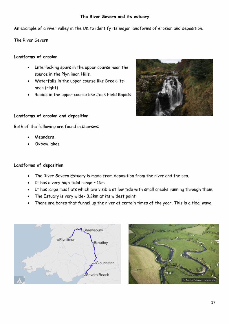
Waterfalls in the upper course like Break-its-
neck (right)
Rapids in the upper course like Jack Field Rapids
Landforms of erosion and deposition
Both of the following are found in Caersws:
Meanders
Oxbow lakes
Landforms of deposition
The River Severn Estuary is made from deposition from the river and the sea.
It has a very high tidal range – 15m.
It has large mudflats which are visible at low tide with small creeks running through them.
The Estuary is very wide- 3.2km at its widest point
There are bores that funnel up the river at certain times of the year. This is a tidal wave.
18
Jubilee River flood-relief channel
An example of a flood management scheme in the UK to
show:
why the scheme was required
the management strategy
the social, economic and environmental issues.
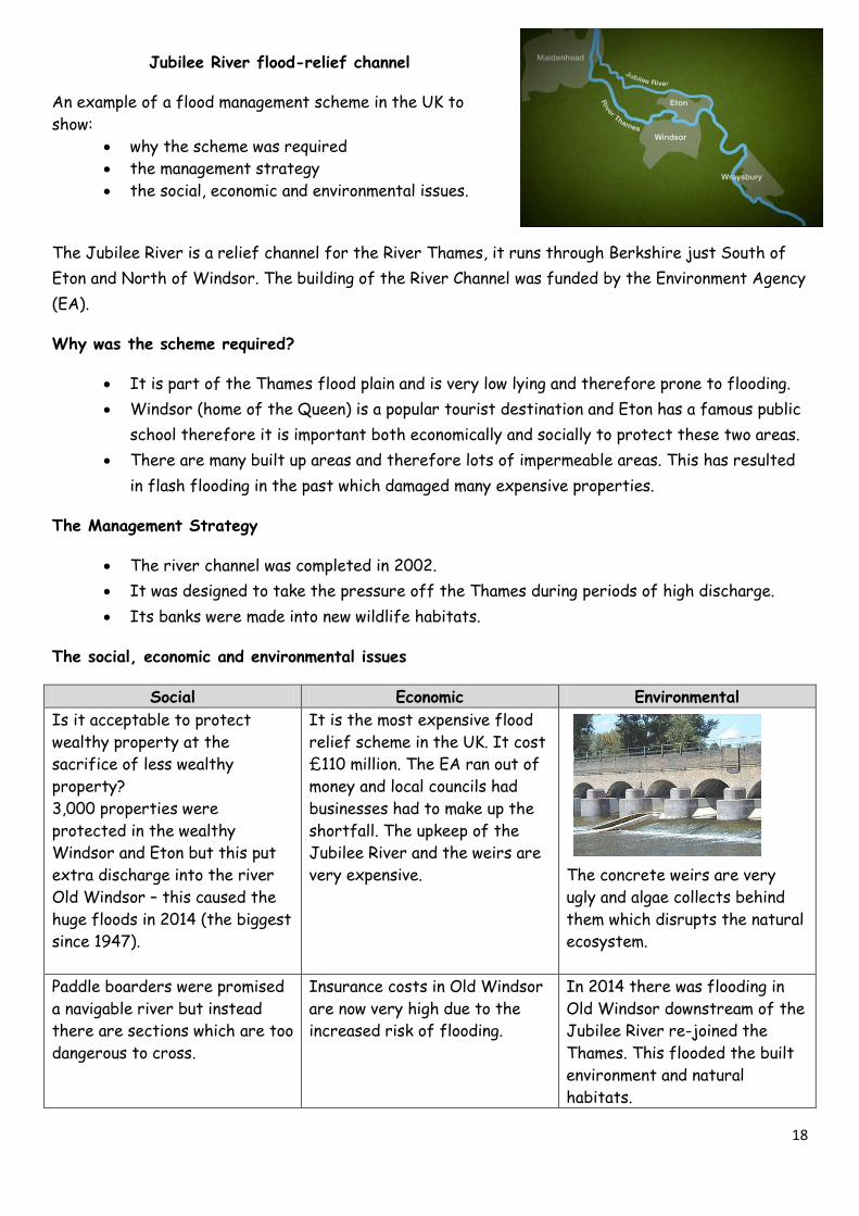
The Jubilee River is a relief channel for the River Thames, it runs through Berkshire just South of
Eton and North of Windsor. The building of the River Channel was funded by the Environment Agency
(EA).
Why was the scheme required?
It is part of the Thames flood plain and is very low lying and therefore prone to flooding.
Windsor (home of the Queen) is a popular tourist destination and Eton has a famous public
school therefore it is important both economically and socially to protect these two areas.
There are many built up areas and therefore lots of impermeable areas. This has resulted
in flash flooding in the past which damaged many expensive properties.
The Management Strategy
The river channel was completed in 2002.
It was designed to take the pressure off the Thames during periods of high discharge.
Its banks were made into new wildlife habitats.
The social, economic and environmental issues
Social Economic Environmental
Is it acceptable to protect
wealthy property at the
sacrifice of less wealthy
property?
3,000 properties were
protected in the wealthy
Windsor and Eton but this put
extra discharge into the river
Old Windsor – this caused the
huge floods in 2014 (the biggest
since 1947).
It is the most expensive flood
relief scheme in the UK. It cost
£110 million. The EA ran out of
money and local councils had
businesses had to make up the
shortfall. The upkeep of the
Jubilee River and the weirs are
very expensive.
The concrete weirs are very
ugly and algae collects behind
them which disrupts the natural
ecosystem.
Paddle boarders were promised
a navigable river but instead
there are sections which are too
dangerous to cross.
Insurance costs in Old Windsor
are now very high due to the
increased risk of flooding.
In 2014 there was flooding in
Old Windsor downstream of the
Jubilee River re-joined the
Thames. This flooded the built
environment and natural
habitats.
19
Test yourself
1. Give two named landforms of erosion on the Dorset coast.
2. Give two named landforms of deposition on the Dorset coast.
3. Give two reasons why Medmerry needed a different coastal management strategy and why was
costal realignment chosen?
4. How many tonnes of rock armour were used to line the embankments?
5. Give one social, economic and environmental positive of the coastal realignment scheme at
Medmerry.
6. Give one social, economic and environmental negative of the coastal realignment scheme at
Medmerry.
7. What is your example of a river valley?
8. Give 5 features of your river valley – try and be specific if you can – e.g. what is the waterfall
called in the upper course?
9. The Jubilee flood relief scheme was a flood relief channel for which river?
10. Which two urban areas were being protected from flooding by building the Jubilee flood
relief channel?
11. When was the Jubilee flood relief channel finished?
12. Give one social, economic and environmental issue with the Jubilee flood relief channel.
Physical landscapes in the UK possible questions- could you answer them?
Remember to PEEL for 6/9 markers. Point, evidence, explanation, link back to the question.
Assess the different management strategies that can be used to protect coastlines from the effects
of physical processes. [6 marks]
Use a named case study to assess the different management strategies that have been used to
protect coastlines. [6 marks]
Evaluate the different management strategies that can be used to protect river landscapes from the
effects of flooding. [6 marks]
Use a named case study to evaluate the different management strategies that have been used to
protect river landscapes from the effects of flooding. [6 marks]
Using an example from a section of coastline in the UK, explain how erosion and deposition can shape
a coastline. [6 marks]
Discuss the importance of geology and rock types in shaping the coastline. [6 marks]
“Hard engineering is a more effective coastal management strategy than soft engineering.” To what
extent do you agree? [6 marks]
20
A case study of a major city in an LIC
1. The location and importance of the city, regionally, nationally and internationally
Lagos is located in Nigeria, West Africa
2. Causes of growth: natural increase and migration
Lagos has a rapid natural increase. This is because Nigeria has a high birth rate and a
decreasing death rate. It is also due to push and pull factors which are pushing people away
from rural areas and pulling people to the urban centre of Lagos. This is migration.
Push factors (from rural areas) Pull factors (to urban Lagos)
Farming pays low wages and is hard work The ‘bright lights’ effect draws people in.
Few job opportunities exist in rural areas
other than farming – this makes young
people in particular vulnerable.
Young people want to seek their fortune in
the Lagos.
Education and health services are poor Education and health care services are
better in the city.
Climate change is making floods and
droughts more common – this makes crop
yields unpredictable.
Land is degraded by the oil industry making
farming more difficult
The north of Nigeria is politically unstable
and there has been lots of terrorist activity
by Boko Haram.
3. How urban growth has created social opportunities: access to services – health and
education; access to resources – water supply, energy.
Access to services
Health Healthcare is closer and more available in Lagos – even if it is not free.
Education There are more schools and universities giving people more chances in life.
Access to resources
Water supply The wealthiest homes have piped water – everyone else has access via taps or
buy their water from street vendors.
Energy Electricity is more widespread however is stretched due to the sheer number
of people. Two new power stations are currently being built to give enough
energy for the city. Businesses rely on generators in case main power fails.
Regional importance National Importance International importance
It has the fastest growing
population in Lagos as well as
the city with the fastest
growing economy.
80% of Nigeria’s industry is
based in and around Lagos.
It is the financial and
business centre of Nigeria.
It has a busy seaport and
airport.
Lagos has ambitions to be
the first ‘World city’ in
Africa. It is predicted to be
the richest city in Africa by
2050.
21
4. How urban growth has created economic opportunities: how urban industrial areas can be a
stimulus for economic development
Lagos has been exporting oil. This has brought wealth and industrialisation on the coast of
Lagos. Once factories start being built this creates more wealth and jobs which in turn
brings more factories, wealth and jobs.
Lagos is now using this wealth and investment from other countries to build a new city on
the coast called Eko – it is set to be the new financial hub of West Africa.
5. How urban growth has created challenges such as managing urban growth – slums, squatter
settlements.
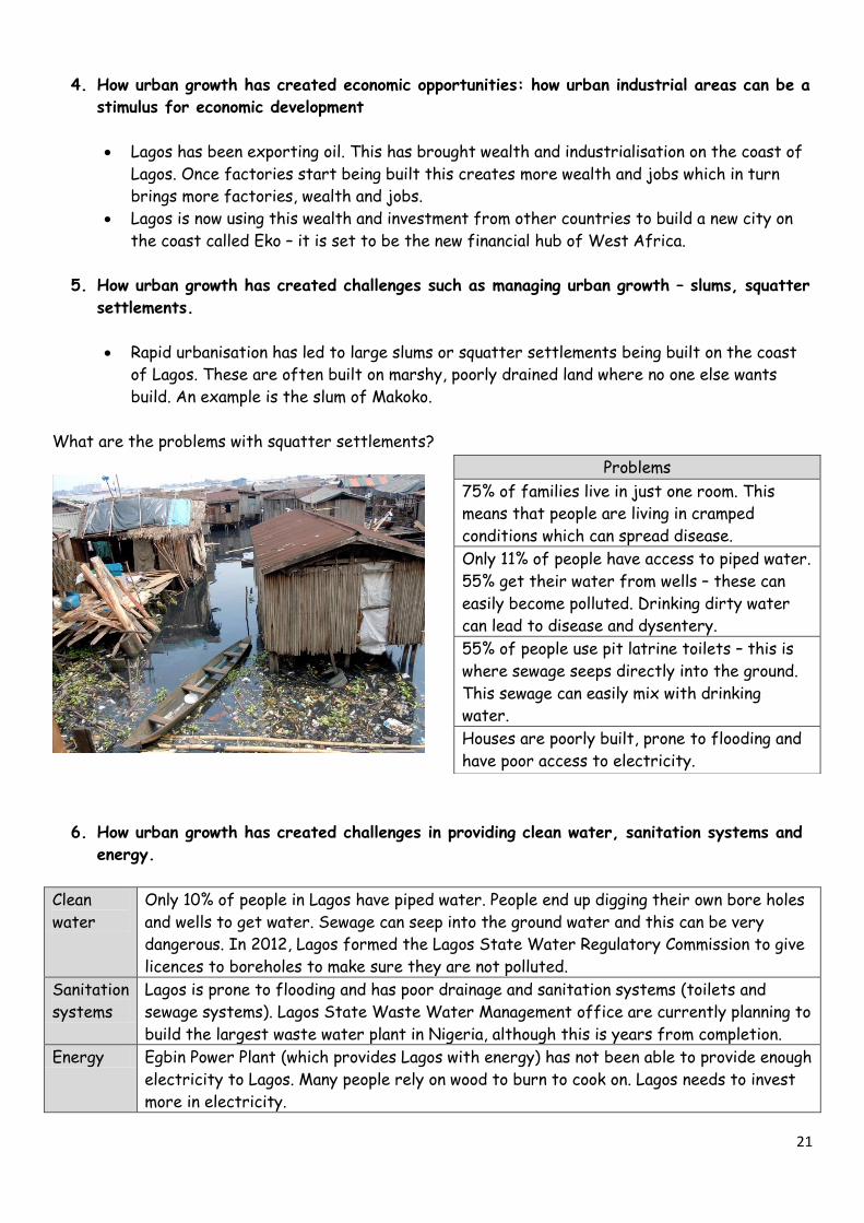
Rapid urbanisation has led to large slums or squatter settlements being built on the coast
of Lagos. These are often built on marshy, poorly drained land where no one else wants
build. An example is the slum of Makoko.
What are the problems with squatter settlements?
6. How urban growth has created challenges in providing clean water, sanitation systems and
energy.
Clean
water
Only 10% of people in Lagos have piped water. People end up digging their own bore holes
and wells to get water. Sewage can seep into the ground water and this can be very
dangerous. In 2012, Lagos formed the Lagos State Water Regulatory Commission to give
licences to boreholes to make sure they are not polluted.
Sanitation
systems
Lagos is prone to flooding and has poor drainage and sanitation systems (toilets and
sewage systems). Lagos State Waste Water Management office are currently planning to
build the largest waste water plant in Nigeria, although this is years from completion.
Energy Egbin Power Plant (which provides Lagos with energy) has not been able to provide enough
electricity to Lagos. Many people rely on wood to burn to cook on. Lagos needs to invest
more in electricity.
Problems
75% of families live in just one room. This
means that people are living in cramped
conditions which can spread disease.
Only 11% of people have access to piped water.
55% get their water from wells – these can
easily become polluted. Drinking dirty water
can lead to disease and dysentery.
55% of people use pit latrine toilets – this is
where sewage seeps directly into the ground.
This sewage can easily mix with drinking
water.
Houses are poorly built, prone to flooding and
have poor access to electricity.
22
7. How urban growth has created challenges providing access to services like health and
education.
Due to huge rural – urban migration it is difficult for Lagos’s government to provide enough schools
and hospitals. Healthcare is not free either.
8. Reducing unemployment and crime
Unemployment in Lagos is lower than the rest of Nigeria. Most people are employed but in
low skilled, low paid jobs. People work in the informal economy often working washing cars,
street selling of waste recycling on landfill sites, sorting waste and finding items that they
can sell. Jobs are being created in new factories and in the tertiary industry which is
growing.
Lagos has high crime levels especially in drug trafficking and gangs. Lagos’s government is
trying to reduce crime but lack of resources and policing make it difficult.
9. Managing environmental issues – waste disposal, air and water pollution, traffic congestion
Waste disposal Air and water pollution Traffic congestion
The Olusosun landfill is a 100-
acre dump in Lagos – it is the
largest in Africa and one of the
largest in the world.
There is high levels of air
pollution caused by traffic on
very congested roads. It is
trying to increase public
transport to reduce this.
In 2003 the Lagos Metropolitan
Area Transport Authority
(LAMATA) created a bus rapid
transit (BRT) to take people
from the suburbs to the CBD.
They have built a separate bus
lane too which takes 200,000
every day (but still on just 25%
of commuters in Lagos)
Lagos is running out of space
and so waste is sometimes being
incinerated as well creating
toxic fumes.
Oil, chemicals and sewage seep
into ground water. In 2012,
Lagos formed the Lagos State
Water Regulatory Commission
to give licences to boreholes to
make sure they are not polluted.
A new light railway has been
built from East to West. Lagos’s
governments are planning to
build 7 more railways.
An integrated transport system in Lagos?
Lagos wants to create an integrated transport system as they know all good cities need good
transport. They are planning to do the following:
Ferries to transport people over and across the river mouth.
Removing obstacles in roads like markets and street vendors.
Better urban planning so that there are businesses and homes through-out the city to
prevent everybody from having to commute.
23
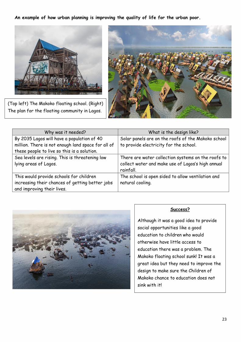
An example of how urban planning is improving the quality of life for the urban poor.
Why was it needed? What is the design like?
By 2035 Lagos will have a population of 40
million. There is not enough land space for all of
these people to live so this is a solution.
Solar panels are on the roofs of the Makoko school
to provide electricity for the school.
Sea levels are rising. This is threatening low
lying areas of Lagos.
There are water collection systems on the roofs to
collect water and make use of Lagos’s high annual
rainfall.
This would provide schools for children
increasing their chances of getting better jobs
and improving their lives.
The school is open sided to allow ventilation and
natural cooling.
(Top left) The Makoko floating school. (Right)
The plan for the floating community in Lagos.
Success?
Although it was a good idea to provide
social opportunities like a good
education to children who would
otherwise have little access to
education there was a problem. The
Makoko floating school sunk! It was a
great idea but they need to improve the
design to make sure the Children of
Makoko chance to education does not
sink with it!
24
Major city in the UK: London
A case study of a major city in the UK to illustrate:
1. The location and importance of the city in the UK and the wider world.
Regional importance National importance Global importance
Many people in surrounding
counties commute into
London and it provides
many jobs for people.
London is of huge economic importance
for the country as it is the centre of
trade and finance. It also holds much
importance in terms of education,
media, government and culture.
London is a ‘World City’ which
means that it is one of the
most important financial
centres in the world.
2. Impacts of national and international migration on the growth and character of the city
Migration has had a huge impact on the character of the city. It is the most ethnically
diverse place in the UK.
Each group of new migrants brought with them their own culture, traditions, religions,
music and food. This goes back as far as the Saxons – each group of people leaving their
mark on London.
3. How urban change has created social and economic opportunities: cultural mix, recreation
and entertainment, employment, integrated transport systems.
Cultural mix Places like Brick Lane have an amazing variety of food, art and music from different
places. It is a melting pot for culture making it very culturally rich.
Recreation and
entertainment
There are many theatres like the National Theatre, art galleries like the Tate
Modern, music festivals and venues such as Love Box and The Proms.
Employment There is a huge variety of employment from jobs in the financial centre which are
very high paid to low paid service jobs like bar staff and cleaners. There is a huge
quantity of people needed to work to make London a World City.
Integrated
transport
system
London has buses, 240 tube stations, the Docklands light railway, Boris Bikes, bus
lanes, ferries, London city Airport and Heathrow airport which are all designed to
keep London running.
4. Environmental: urban greening
Urban greening is about increasing the amount of green space that cities have. London is already a
green city as it has many parks so it is about maintaining what they have and continue to improve it.
Increasing green infrastructure like roof top gardens, and green walls and roofs.
Creating a ‘green grid’ – basically connecting green spaces together with rows of trees or
green infrastructure to make it easier for wildlife to migrate. This is done though
maintaining trees, hedgerows and parks.
25
5. How urban change has created social and economic challenges: urban deprivation,
inequalities in housing, education, health and employment.
Urban
deprivation
Some areas of London are very deprived. For example in Newham over 50% of people
are receiving benefits. Life expectancy is an indicator of deprivation. In London if you
travel from West Ham to Knightsbridge on the Jubilee line life expectancy increases
from 78 years to 90 years – that’s 12 years difference just depending where you live!
Inequalities
in housing
There is not enough housing in London and many people who have grown up in London
will struggle to ever get a house. Many rented houses are overpriced and are in poor
condition. This has been made worse in recent years.
Education The quality of schools vary largely depending on where they are. It is always a big
struggle to provide enough good schools and it is very competitive amongst parents.
Health People can have very different levels of health depending on where they live. This is
due to poverty and deprivation.
Employment Unemployment increases in areas which are more deprived. Often people do not have
the skills or education to have employment and if they do it is poorly paid. Many people
in Tower Hamlets (a poor area) cannot get jobs in Canary Warf despite the close
distance.
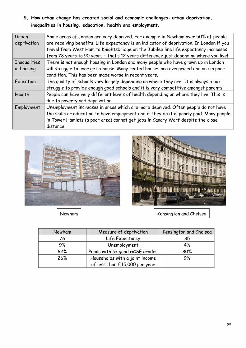
Newham Measure of deprivation Kensington and Chelsea
76 Life Expectancy 85
9% Unemployment 4%
62% Pupils with 5+ good GCSE grades 80%
26% Households with a joint income
of less than £15,000 per year
9%
Newham Kensington and Chelsea
26
6. How urban change has created environmental challenges: dereliction, building on brownfield
and greenfield sites, waste disposal.
Dereliction Many factories shut down as countries like China started manufacturing. This meant
lots of factory buildings became derelict and houses nearby became vacant. This led to
increased crime and the buildings became run down and covered in graffiti. This
reduces the environmental quality of the area and makes it unpopular with people and
business. Many of these areas have now been regenerated.
Waste
disposal
London produces a huge amount of waste. 25% still goes to landfill and this is
unsustainable. 61% is recycled. The target is that 0% of London’s waste should go to
Landfill by 2030. This will be achieved by less packaging and incinerating waste to
make electricity for example in London EcoPark, Enfield (an incinerator).
Should we build on greenfield or brown field sites to make enough houses for London’s population?
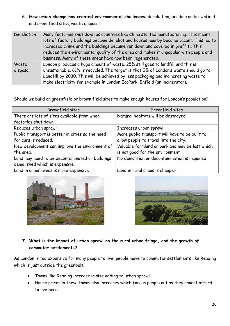
Brownfield sites Greenfield sites
There are lots of sites available from when
factories shut down.
Natural habitats will be destroyed.
Reduces urban sprawl Increases urban sprawl
Public transport is better in cities so the need
for cars is reduced.
More public transport will have to be built to
allow people to travel into the city.
New development can improve the environment of
the area.
Valuable farmland or parkland may be lost which
is not good for the environment
Land may need to be decontaminated or buildings
demolished which is expensive.
No demolition or decontamination is required
Land in urban areas is more expensive Land in rural areas is cheaper
7. What is the impact of urban sprawl on the rural–urban fringe, and the growth of
commuter settlements?
As London is too expensive for many people to live, people move to commuter settlements like Reading
which is just outside the greenbelt.
Towns like Reading increase in size adding to urban sprawl.
House prices in these towns also increases which forces people out as they cannot afford
to live here.
27
Urban Regeneration: The London Olympics
An example of an urban regeneration project to show:
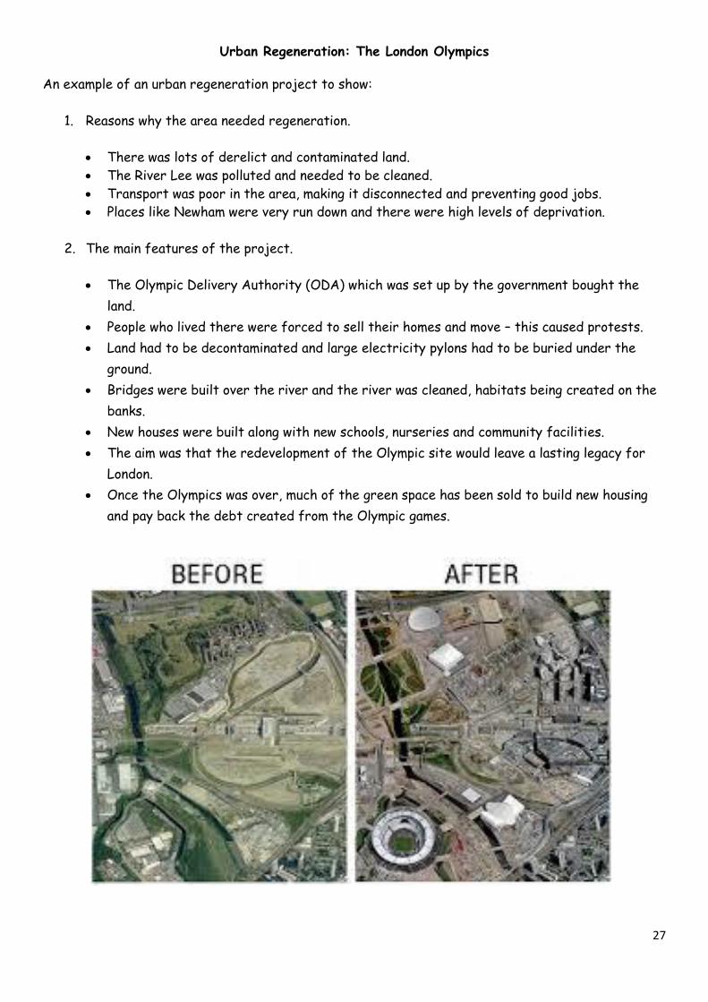
1. Reasons why the area needed regeneration.
There was lots of derelict and contaminated land.
The River Lee was polluted and needed to be cleaned.
Transport was poor in the area, making it disconnected and preventing good jobs.
Places like Newham were very run down and there were high levels of deprivation.
2. The main features of the project.
The Olympic Delivery Authority (ODA) which was set up by the government bought the
land.
People who lived there were forced to sell their homes and move – this caused protests.
Land had to be decontaminated and large electricity pylons had to be buried under the
ground.
Bridges were built over the river and the river was cleaned, habitats being created on the
banks.
New houses were built along with new schools, nurseries and community facilities.
The aim was that the redevelopment of the Olympic site would leave a lasting legacy for
London.
Once the Olympics was over, much of the green space has been sold to build new housing
and pay back the debt created from the Olympic games.
28
Test Yourself
1. Describe the location of Lagos.
2. Explain why Lagos is an important city, regionally, nationally and internationally.
3. Give two push factors and two pull factors for rural-urban migration to Lagos.
4. Why has Lagos got a high natural increase.
5. How has urban growth led to opportunities in services and resources. Give two examples.
6. Lagos’s urban growth has given many economic opportunities. It is currently building a new city
off the coast using this wealth. What is this called?
7. What is a squatter settlement?
8. Give 3 problems for people living in squatter settlements.
9. What % of people in Lagos have piped water? What is Lagos State Water Regulatory
Commission doing about this?
10. What are the challenges connected to sanitation systems?
11. How big is the Olusosun landfill in Nigeria? Why is dealing with waste a problem?
12. How are Lagos’s government trying to deal with traffic congestion?
13. What is the floating school called? Why could this type of urban planning help the lives of the
urban poor in Lagos?
14. Explain what the regional, national and global importance on London is.
15. How has migration affected London?
16. Give 4 examples to prove why London has an integrated transport system.
17. Give two facts about employment and recreation in London.
18. What is the idea of the ‘green grid’ and how is this linked to urban greening?
19. What happens when you travel from West Ham to Knightsbridge on the Jubilee Line in
London?
20. Why could Newham be considered to be a deprived area? How does this have social, economic
and environmental effects?
21. How does unemployment vary between Newham and Kensington and Chelsea.
22. Give two advantages and two disadvantages of greenfield and brownfield sites.
23. Why is urban sprawl happening around London and what impact is this having on towns like
Reading?
24. Why did the lower Lee Valley need to be regenerated? Give 3 features of the project.

29
Urban Issues and Challenges possible questions- could you answer them?
Remember to PEEL for 6/9 markers. Point, evidence, explanation, link back to the
question.
Using a named case study in a LIC assess/discuss how urban planning is improving the quality of life
for the urban poor.
Using a named case study in the UK discuss the reasons why the area was regenerated and give the
main features of the urban regeneration project.
Assess/evaluate urban transport strategies that are used to reduce traffic congestion.
Using a case study of a major city in an LIC or NEE explain the importance of this city the regionally,
nationally and internationally. [6 Marks]
Explain the causes of urban growth in an LIC you have studied. [4 Marks]
Discuss how rapid urban growth in LICs created both social opportunities and challenges. [9 Marks]
Describe how increasing industrial areas in the poor world can be a stimulus for economic
development. [4 Marks]
Assess the challenges that urban growth in the poor world has created such as providing housing,
clean water and sanitation. [6 Marks]
“The challenges faced to urban areas in LICs are similar to those challenges faced in HICs”. Using
examples, discuss to what extent you agree with this statement. [9 Marks]
In cities in LICs social challenges are far greater than either economic or environmental ones. To
what extent do you agree? [9 Marks]
Using an example, assess how well urban planning in an LIC is improving the quality of life for the
urban poor. [6 Marks]
Describe the impact of urban sprawl and growth of commuter settlements on the rural-urban fringe.
[4 Marks]
Explain the opportunities and challenges of building on brownfield and greenfield sites. [6 Marks]
Assess the social and economic challenges for cities in the richer world. [9 Marks]
Using an example of a city in the UK, evaluate the impacts of national and international migration on
the growth and character of the city. [9 Marks]
Assess the usefulness of the integrated transport system in a city of your choice.
Outline the concept of urban greening. [3 marks]
Using a case study of a major city in the UK, discuss the opportunities created by urban change [9
marks]
30
The Changing Economic World
An example of how the growth of tourism in an LIC or NEE helps to reduce the development gap.
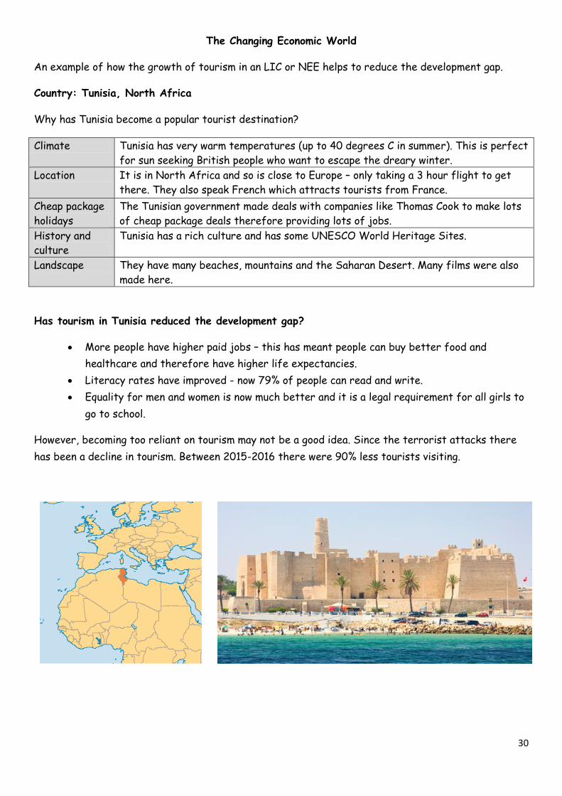
Country: Tunisia, North Africa
Why has Tunisia become a popular tourist destination?
Climate Tunisia has very warm temperatures (up to 40 degrees C in summer). This is perfect
for sun seeking British people who want to escape the dreary winter.
Location It is in North Africa and so is close to Europe – only taking a 3 hour flight to get
there. They also speak French which attracts tourists from France.
Cheap package
holidays
The Tunisian government made deals with companies like Thomas Cook to make lots
of cheap package deals therefore providing lots of jobs.
History and
culture
Tunisia has a rich culture and has some UNESCO World Heritage Sites.
Landscape They have many beaches, mountains and the Saharan Desert. Many films were also
made here.
Has tourism in Tunisia reduced the development gap?
More people have higher paid jobs – this has meant people can buy better food and
healthcare and therefore have higher life expectancies.
Literacy rates have improved - now 79% of people can read and write.
Equality for men and women is now much better and it is a legal requirement for all girls to
go to school.
However, becoming too reliant on tourism may not be a good idea. Since the terrorist attacks there
has been a decline in tourism. Between 2015-2016 there were 90% less tourists visiting.
31
Nigeria
A case study of one LIC or NEE to illustrate:
1. The location and importance of the country, regionally and globally.
Nigeria is considered as the ‘Giant of Africa’. It has a huge population and in 2015 took
over from South Africa as the country with the largest economy.
It is one of the MINT economies – important globally for exporting goods.
It is in the top 20 economies in the world.
2. The wider political, social, cultural and environmental context within which the country is
placed.
Social context Nigeria was originally made of many tribal communities until the British took over.
Cultural context There are 500 ethnic groups each with its own language but three major
ethnicities. The North of Nigeria is mainly Muslim, the South is mainly Christian.
Environmental
context
It is just north of the Equator. The south of Nigeria is humid and has tropical
rainforest and in the north is hot and dry savannah.
Political context Nigeria gained independence in 1960. Although it had a civil war it now has a
working democracy. However there is still conflict with Boko Haram, at least
17,000 people have been killed in this conflict since 2002.
3. The changing industrial structure. The balance between different sectors of the
economy. How manufacturing industry can stimulate economic development
Nigeria’s economy is made up of: services 52%, oil and gas 14%, manufacturing 7% and
agriculture 22%.
The majority of people (30%) in Nigeria work in agriculture. 25% work in retail and
maintenance.
Finding and exploiting oil kick-started the Nigerian economy. This gave money which funded
factories to be built and started turning Nigeria from an LIC into a HIC. New industry like
this creates jobs, creates wealth through taxes and improves the wealth of the country.
4. The role of transnational corporations (TNCs) in relation to industrial development.
Advantages and disadvantages of TNC(s) to the host country
TNCs like Shell and Exxon-mobil have the money and expertise to drill for oil. The TNCs
made deals with the Nigerian government who didn’t have this money or expertise to
export this oil.
Advantages Disadvantages
Increases the wealth of the country. Oil creates environmental damage. Oil spills kill
wildlife and damage ecosystems
TNCs often improve infrastructure of the
country
TNCs are footloose meaning they can leave lots of
people suddenly without a job.
New skills and expertise are brought in Profits are taken aboard – economic leakage
32
5. The changing political and trading relationships with the wider world.
Nigeria and the UK Nigeria and China
Oil is transported to the UK. Manufactured goods
are traded with the UK.
China is investing hugely in Nigeria. It is drilling a
new oil field in Nigeria and investing in transport.
It knows that it will make its money back when
Nigeria becomes richer.
6. International aid: types of aid, impacts of aid on the receiving country.
Type of aid What is it?
Official
developmental
assistance
Multilateral aid – money given by the world bank
Bilateral aid – given by one country to another (often with conditions like a promise
to buy goods from the donor country with the aid money). A bit like Tesco giving you
a voucher to spend at Tesco.
Voluntary aid –
NGOs like
Oxfam
Short-term emergency relief – aid like after an earthquake
Long-term development assistance – such as education or appropriate technology to
help their farmland.
Nigeria got into debt by borrowing money from the UK and America. We made them pay it
back with interest. Nigeria are now wealthy and have their own space programme but the
60% of the population still only own $1.25 per day. People often criticise this.
7. The environmental impacts of economic development.
Oil pollution has polluted the sea and delta of Nigeria near Lagos.
Deforestation has occurred in the rainforest
Lagos has got high air pollution and breathing conditions are poor
Industry along the river has caused chemicals to leak into the water.
8. The effects of economic development on quality of life for the population.
There are large inequalities in Nigeria. Even though the country is booming economically
not all of this money is going where it needs to.
Better jobs = better pay = more taxes and better living standards
Many Nigerians are not happy by their low wages and end up travelling to North Africa to
travel across the Mediterranean Sea to try and get to Europe so people can seek a better
life.
33
The UK car industry
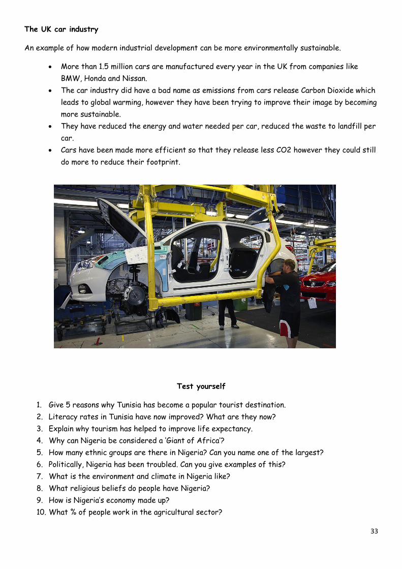
An example of how modern industrial development can be more environmentally sustainable.
More than 1.5 million cars are manufactured every year in the UK from companies like
BMW, Honda and Nissan.
The car industry did have a bad name as emissions from cars release Carbon Dioxide which
leads to global warming, however they have been trying to improve their image by becoming
more sustainable.
They have reduced the energy and water needed per car, reduced the waste to landfill per
car.
Cars have been made more efficient so that they release less CO2 however they could still
do more to reduce their footprint.
Test yourself
1. Give 5 reasons why Tunisia has become a popular tourist destination.
2. Literacy rates in Tunisia have now improved? What are they now?
3. Explain why tourism has helped to improve life expectancy.
4. Why can Nigeria be considered a ‘Giant of Africa’?
5. How many ethnic groups are there in Nigeria? Can you name one of the largest?
6. Politically, Nigeria has been troubled. Can you give examples of this?
7. What is the environment and climate in Nigeria like?
8. What religious beliefs do people have Nigeria?
9. How is Nigeria’s economy made up?
10. What % of people work in the agricultural sector?
34
11. How did finding oil help Nigeria develop?
12. Give two advantages of TNCs in Nigeria.
13. Give two disadvantages of TNCs in Nigeria.
14. What is official developmental assistance?
15. What is the difference between multilateral and bilateral aid?
16. How can NGOs help Nigeria?
17. Give two environmental impacts of economic development.
18. Give two impacts on the quality of life of economic development.
19. How many cars are manufactured in the UK? Give an example of one of the companies.
20. Give two ways the car industry has been made more environmentally sustainable.
The Changing economic world possible questions- could you answer them?
Remember to PEEL for 6/9 markers. Point, evidence, explanation, link back to the
question.
Assess the limitations of using economic and social measures of development. [6 marks]
Discuss the consequences of uneven development. [6 marks]
Describe and explain the strategies used to reduce the development gap. [6 marks]
Using a named case study evaluate how tourism in a LIC or NEE helps to reduce the development gap.
[9 marks]
Using a case study of a named LIC / NEE which has experienced rapid economic development discuss
the social changes this has brought. [6 marks]
Assess the environmental change caused by the rapid economic development discuss the
environmental change in an LIC/NEE you have studied. [9 marks]
Describe and explain the cultural changes that have happened as a result of rapid economic
development in a poorer part of the world that you have studied. [9 marks]
Outline the causes of economic change in the UK. [4 marks]
Using a named case study assess the impacts of industry on the physical environment. [6 marks]
Assess the place of the UK in the wider world. [6 marks]
Assess the success of the strategies used to resolve the regional differences in the north-south
divide in the UK. [6 marks]
Describe and explain the consequences of uneven development. [6 marks]
Suggest how the demographic transition model links to different level of development [4 marks]
Using a case study of a poorer part of the world, describe how the balance between different
sectors of the economy is changing. [6 marks]
35
The challenge of Resource Management
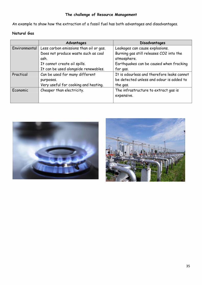
An example to show how the extraction of a fossil fuel has both advantages and disadvantages.
Natural Gas
Advantages Disadvantages
Environmental Less carbon emissions than oil or gas.
Does not produce waste such as coal
ash.
It cannot create oil spills.
It can be used alongside renewables.
Leakages can cause explosions.
Burning gas still releases CO2 into the
atmosphere.
Earthquakes can be caused when fracking
for gas.
Practical Can be used for many different
purposes.
Very useful for cooking and heating.
It is odourless and therefore leaks cannot
be detected unless and odour is added to
the gas.
Economic Cheaper than electricity. The infrastructure to extract gas is
expensive.
36
An example of a local renewable energy scheme in an LIC or NEE to provide sustainable supplies of
energy.
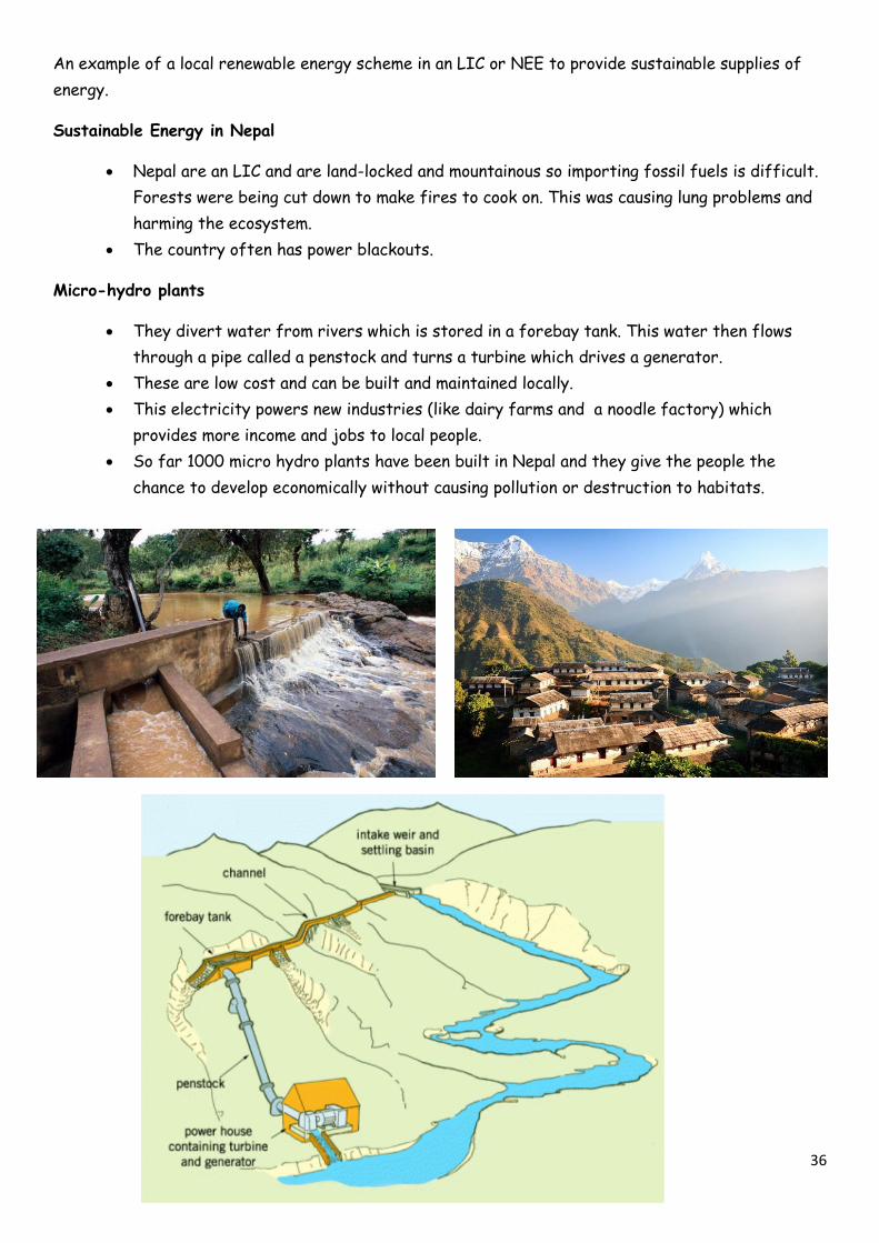
Sustainable Energy in Nepal
Nepal are an LIC and are land-locked and mountainous so importing fossil fuels is difficult.
Forests were being cut down to make fires to cook on. This was causing lung problems and
harming the ecosystem.
The country often has power blackouts.
Micro-hydro plants
They divert water from rivers which is stored in a forebay tank. This water then flows
through a pipe called a penstock and turns a turbine which drives a generator.
These are low cost and can be built and maintained locally.
This electricity powers new industries (like dairy farms and a noodle factory) which
provides more income and jobs to local people.
So far 1000 micro hydro plants have been built in Nepal and they give the people the
chance to develop economically without causing pollution or destruction to habitats.
37
Test yourself
1. Give one environmental advantage and disadvantage of natural gas.
2. Give one practical advantage and disadvantage of natural gas.
3. Give one economic advantage and disadvantage of natural gas.
4. What is Nepal like as a country? (e.g. LIC? HIC?)
5. Why did Nepal need a local renewable energy scheme?
6. How do micro hydro plants work?
7. How have micro hydro plants stimulated economic development in Nepal?
8. Why are micro hydro plants economically sustainable?
9. Why are micro hydro plants socially sustainable?
10. How many micro hydro plants are built in Nepal?
The Challenge of resource management possible questions- could you answer them?
Remember to PEEL for 6/9 markers. Point, evidence, explanation, link back to the question.
Discuss the economic and environmental issues associated with exploitation of energy sources. [6
Marks]
Explain how carbon footprints are related to food miles. [4 Marks]
Outline how inequalities in water availability in the UK can be addressed [4 Marks]
Assess the impacts of energy insecurity. [6 Marks]
Describe and explain why the demand for food has changed in the UK [4 Marks]
Discuss a range of strategies to increase energy supply. [6 Marks]
Explain reasons for the increasing energy consumption. [4 Marks]
Discuss the different factors which affect energy supply [6 Marks]
Using an example, explain how extracting fossil fuels has both advantages and disadvantages. [6
Marks]
Describe a variety of strategies that can be used to conserve energy. [4 Marks]