Embed Size (px)
Citation preview
Garmin MapSource (MPS), GPS Database (GDB) andFolder and Item (GFI) File Format
Herbert Oppmann
http://www.memotech.franken.de/FileFormats/
2018-01-01
Garmin MapSource (MPS), GPS Database (GDB) and Folder and Item (GFI) File Format 2018-01-01
Page 2
ContentUsage................................................................................................................................................................3Basic data types................................................................................................................................................3Basic structures ................................................................................................................................................3
fint...............................................................................................................................................................3fdouble........................................................................................................................................................4Subclass.......................................................................................................................................................4
General file structure .......................................................................................................................................4General record structure..................................................................................................................................4Records common for MPS, GDB and GFI file format ........................................................................................5
File format record (Type=’D’) ......................................................................................................................5File author information record (Type=’A’)...................................................................................................6Application field (no record!) ......................................................................................................................9
Records specific for MPS and GDB File Format ..............................................................................................10Waypoint record (Type=’W’).....................................................................................................................11Route record (Type=’R’) ............................................................................................................................18Track record (Type=’T’) .............................................................................................................................21Image record (Type=’G’)............................................................................................................................22BirdsEye record (Type=’O’)........................................................................................................................22Map section record (Type=’L’)...................................................................................................................23Image record (Type=’j’) .............................................................................................................................24BirdsEye record (Type=’J’) .........................................................................................................................24Geocaching record (Type=’C’) ...................................................................................................................24Map set name record (Type=’V’)...............................................................................................................25?? record (Type=’E’) ..................................................................................................................................25End of file record (Type=’X’)......................................................................................................................25
Records specific for GFI File Format ...............................................................................................................25Folder information record (Type=’F’) ........................................................................................................25Item record (Type=’I’)................................................................................................................................26Route record (Type=’R’) ............................................................................................................................26Track record (Type=’T’) .............................................................................................................................26Waypoint record (Type=’W’).....................................................................................................................26Birdseye record (Type=’K’) ........................................................................................................................26Birdseye record (Type=’J’) .........................................................................................................................27
References......................................................................................................................................................28Used sources of information .....................................................................................................................28Standards and specifications.....................................................................................................................28Sources of sample files..............................................................................................................................28
Garmin MapSource (MPS), GPS Database (GDB) and Folder and Item (GFI) File Format 2018-01-01
Page 3
Usage
Files with filename extension *.mps are created by Garmin MapSource. MapSource < version 3 used an oldMPS format which is documented separately. From version 3 until and including version 5, the MPS formatdocumented here was the standard format. Starting with version 6, MapSource introduced a slightlymodified format using filename extension *.gdb, but it was still able to produce *.mps files using the Exportmenu entry.
Garmin BaseCamp is the successor of MapSource. It uses the same *.gdb format, but can’t export *.mpsformat anymore. While MapSource saved only on explicit user action, BaseCamp automatically saves thelast state to C:\Users\<username>\AppData\Roaming\Garmin\BaseCamp\Database\<Version> asAllData.gdb. In addition, it stores its user interface data in a very similar *.gfi format in the same directoryas FolderData.gfi.
Garmin HomePort behaves the same as BaseCamp, just that the path for automatic saves isC:\Users\<username>\AppData\Roaming\Garmin\HomePort\Database\<Version>.
This documentation is based on own research and the sources listed in the references section.
Text highlighted like this is where further investigation is needed.
Basic data types
All values are serialized in little-endian byte order (least significant byte first).
Type Length Descriptionbyte 1 8 bit unsigned integer (range 0 .. 255)ushort 2 16 bit unsigned integer (range 0 .. 65535)uint 4 32 bit unsigned integer (range 0 .. 4294967295)ulong 8 64 bit unsigned integer (range 0 .. 18446744073709551615)short 2 16 bit signed integer (range -32768 .. 32767)int 4 32 bit signed integer (range -2147483648 .. 2147483647)long 8 64 bit signed integer (range -9223372036854775808 .. 9223372036854775807)double 8 64 bit floating point value according to [6]char 1 A character in ISO/IEC 8859-1 [7]string 1..n 0-terminated string (may be empty). Character set is either ISO/IEC 8859-1 [7]
or UTF-8 [8].flag 1 A byte, with allowed values 0=no and 1=yesversion 2 An ushort, whose value is computed as major version x 100 + minor version.coord 4 An int which has to be multiplied by 360.0° and divided by 232 to get a longitude
or latitude coordinate.
Basic structures
fintType Contentflag 0=value unknown
1=value givenint If flag=1: Present and content is the value
If flag=0 and File Format Version <= 1.5: Present, but value is to be ignoredelse (flag=0 and File Format Version > 1.5): Not present.
Garmin MapSource (MPS), GPS Database (GDB) and Folder and Item (GFI) File Format 2018-01-01
Page 4
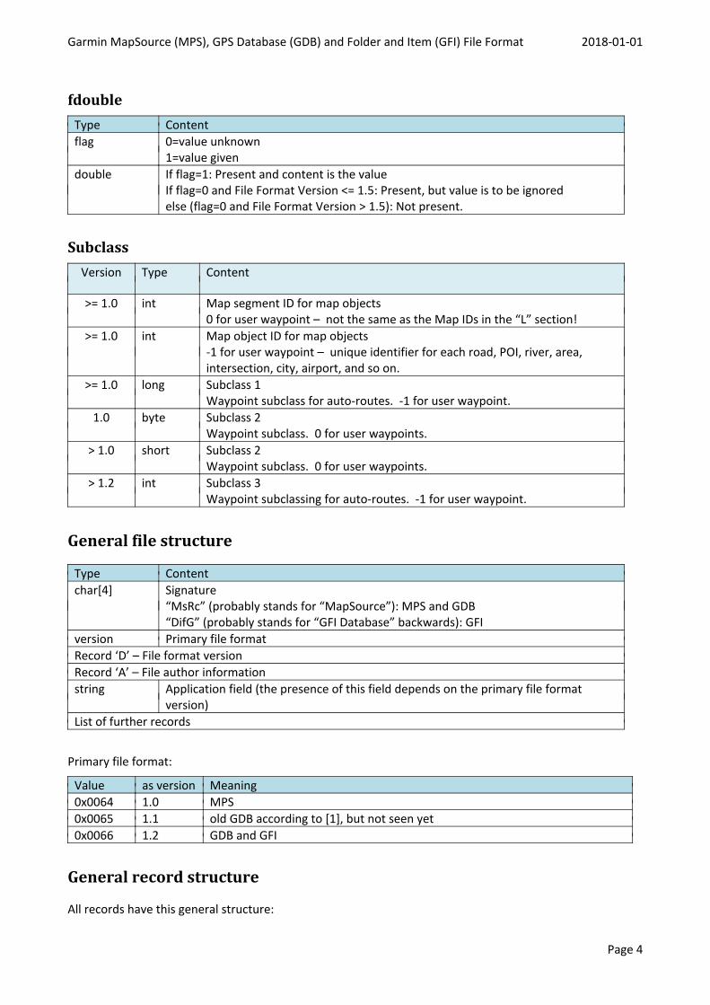
fdoubleType Contentflag 0=value unknown
1=value givendouble If flag=1: Present and content is the value
If flag=0 and File Format Version <= 1.5: Present, but value is to be ignoredelse (flag=0 and File Format Version > 1.5): Not present.
SubclassVersion Type Content
>= 1.0 int Map segment ID for map objects0 for user waypoint – not the same as the Map IDs in the “L” section!
>= 1.0 int Map object ID for map objects-1 for user waypoint – unique identifier for each road, POI, river, area,intersection, city, airport, and so on.
>= 1.0 long Subclass 1Waypoint subclass for auto-routes. -1 for user waypoint.
1.0 byte Subclass 2Waypoint subclass. 0 for user waypoints.
> 1.0 short Subclass 2Waypoint subclass. 0 for user waypoints.
> 1.2 int Subclass 3Waypoint subclassing for auto-routes. -1 for user waypoint.
General file structure
Type Contentchar[4] Signature
“MsRc” (probably stands for “MapSource”): MPS and GDB“DifG” (probably stands for “GFI Database” backwards): GFI
version Primary file formatRecord ‘D’ – File format versionRecord ‘A’ – File author informationstring Application field (the presence of this field depends on the primary file format
version)List of further records
Primary file format:
Value as version Meaning0x0064 1.0 MPS0x0065 1.1 old GDB according to [1], but not seen yet0x0066 1.2 GDB and GFI
General record structure
All records have this general structure:
Garmin MapSource (MPS), GPS Database (GDB) and Folder and Item (GFI) File Format 2018-01-01
Page 5
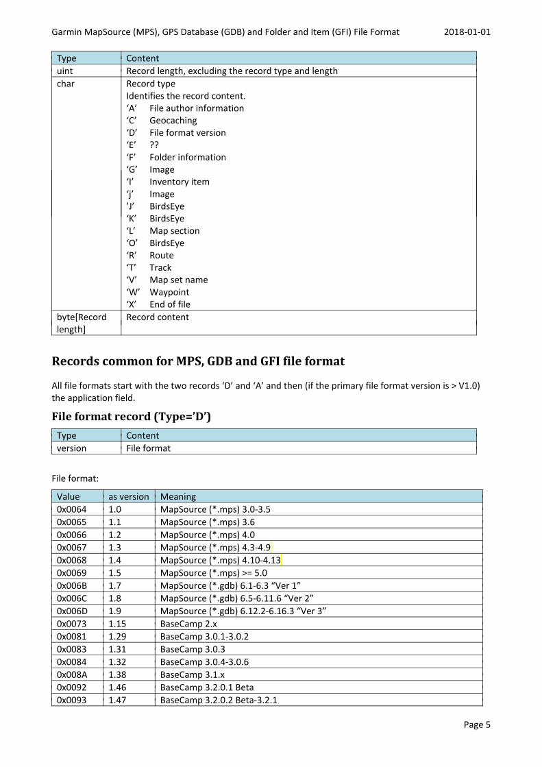
Type Contentuint Record length, excluding the record type and lengthchar Record type
Identifies the record content.‘A’ File author information‘C’ Geocaching‘D’ File format version‘E’ ??‘F’ Folder information‘G’ Image‘I’ Inventory item‘j’ Image’J’ BirdsEye‘K’ BirdsEye‘L’ Map section‘O’ BirdsEye‘R’ Route‘T’ Track‘V’ Map set name‘W’ Waypoint‘X’ End of file
byte[Recordlength]
Record content
Records common for MPS, GDB and GFI file format
All file formats start with the two records ‘D’ and ‘A’ and then (if the primary file format version is > V1.0)the application field.
File format record (Type=’D’)Type Contentversion File format
File format:
Value as version Meaning0x0064 1.0 MapSource (*.mps) 3.0-3.50x0065 1.1 MapSource (*.mps) 3.60x0066 1.2 MapSource (*.mps) 4.00x0067 1.3 MapSource (*.mps) 4.3-4.90x0068 1.4 MapSource (*.mps) 4.10-4.130x0069 1.5 MapSource (*.mps) >= 5.00x006B 1.7 MapSource (*.gdb) 6.1-6.3 “Ver 1”0x006C 1.8 MapSource (*.gdb) 6.5-6.11.6 “Ver 2”0x006D 1.9 MapSource (*.gdb) 6.12.2-6.16.3 “Ver 3”0x0073 1.15 BaseCamp 2.x0x0081 1.29 BaseCamp 3.0.1-3.0.20x0083 1.31 BaseCamp 3.0.30x0084 1.32 BaseCamp 3.0.4-3.0.60x008A 1.38 BaseCamp 3.1.x0x0092 1.46 BaseCamp 3.2.0.1 Beta0x0093 1.47 BaseCamp 3.2.0.2 Beta-3.2.1
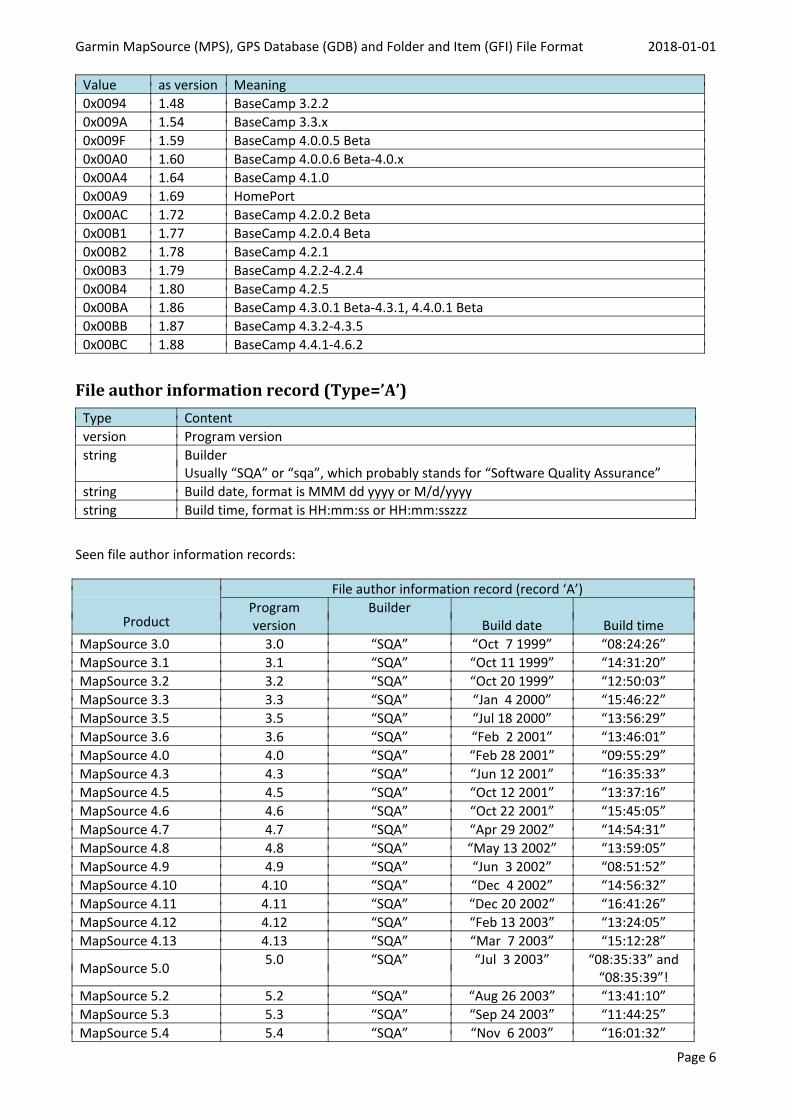
Garmin MapSource (MPS), GPS Database (GDB) and Folder and Item (GFI) File Format 2018-01-01
Page 6
Value as version Meaning0x0094 1.48 BaseCamp 3.2.20x009A 1.54 BaseCamp 3.3.x0x009F 1.59 BaseCamp 4.0.0.5 Beta0x00A0 1.60 BaseCamp 4.0.0.6 Beta-4.0.x0x00A4 1.64 BaseCamp 4.1.00x00A9 1.69 HomePort0x00AC 1.72 BaseCamp 4.2.0.2 Beta0x00B1 1.77 BaseCamp 4.2.0.4 Beta0x00B2 1.78 BaseCamp 4.2.10x00B3 1.79 BaseCamp 4.2.2-4.2.40x00B4 1.80 BaseCamp 4.2.50x00BA 1.86 BaseCamp 4.3.0.1 Beta-4.3.1, 4.4.0.1 Beta0x00BB 1.87 BaseCamp 4.3.2-4.3.50x00BC 1.88 BaseCamp 4.4.1-4.6.2
File author information record (Type=’A’)Type Contentversion Program versionstring Builder
Usually “SQA” or “sqa”, which probably stands for “Software Quality Assurance”string Build date, format is MMM dd yyyy or M/d/yyyystring Build time, format is HH:mm:ss or HH:mm:sszzz
Seen file author information records:
Product
File author information record (record ‘A’)Programversion
BuilderBuild date Build time
MapSource 3.0 3.0 “SQA” “Oct 7 1999” “08:24:26”MapSource 3.1 3.1 “SQA” “Oct 11 1999” “14:31:20”MapSource 3.2 3.2 “SQA” “Oct 20 1999” “12:50:03”MapSource 3.3 3.3 “SQA” “Jan 4 2000” “15:46:22”MapSource 3.5 3.5 “SQA” “Jul 18 2000” “13:56:29”MapSource 3.6 3.6 “SQA” “Feb 2 2001” “13:46:01”MapSource 4.0 4.0 “SQA” “Feb 28 2001” “09:55:29”MapSource 4.3 4.3 “SQA” “Jun 12 2001” “16:35:33”MapSource 4.5 4.5 “SQA” “Oct 12 2001” “13:37:16”MapSource 4.6 4.6 “SQA” “Oct 22 2001” “15:45:05”MapSource 4.7 4.7 “SQA” “Apr 29 2002” “14:54:31”MapSource 4.8 4.8 “SQA” “May 13 2002” “13:59:05”MapSource 4.9 4.9 “SQA” “Jun 3 2002” “08:51:52”MapSource 4.10 4.10 “SQA” “Dec 4 2002” “14:56:32”MapSource 4.11 4.11 “SQA” “Dec 20 2002” “16:41:26”MapSource 4.12 4.12 “SQA” “Feb 13 2003” “13:24:05”MapSource 4.13 4.13 “SQA” “Mar 7 2003” “15:12:28”
MapSource 5.0 5.0 “SQA” “Jul 3 2003” “08:35:33” and“08:35:39”!
MapSource 5.2 5.2 “SQA” “Aug 26 2003” “13:41:10”MapSource 5.3 5.3 “SQA” “Sep 24 2003” “11:44:25”MapSource 5.4 5.4 “SQA” “Nov 6 2003” “16:01:32”
Garmin MapSource (MPS), GPS Database (GDB) and Folder and Item (GFI) File Format 2018-01-01
Page 7
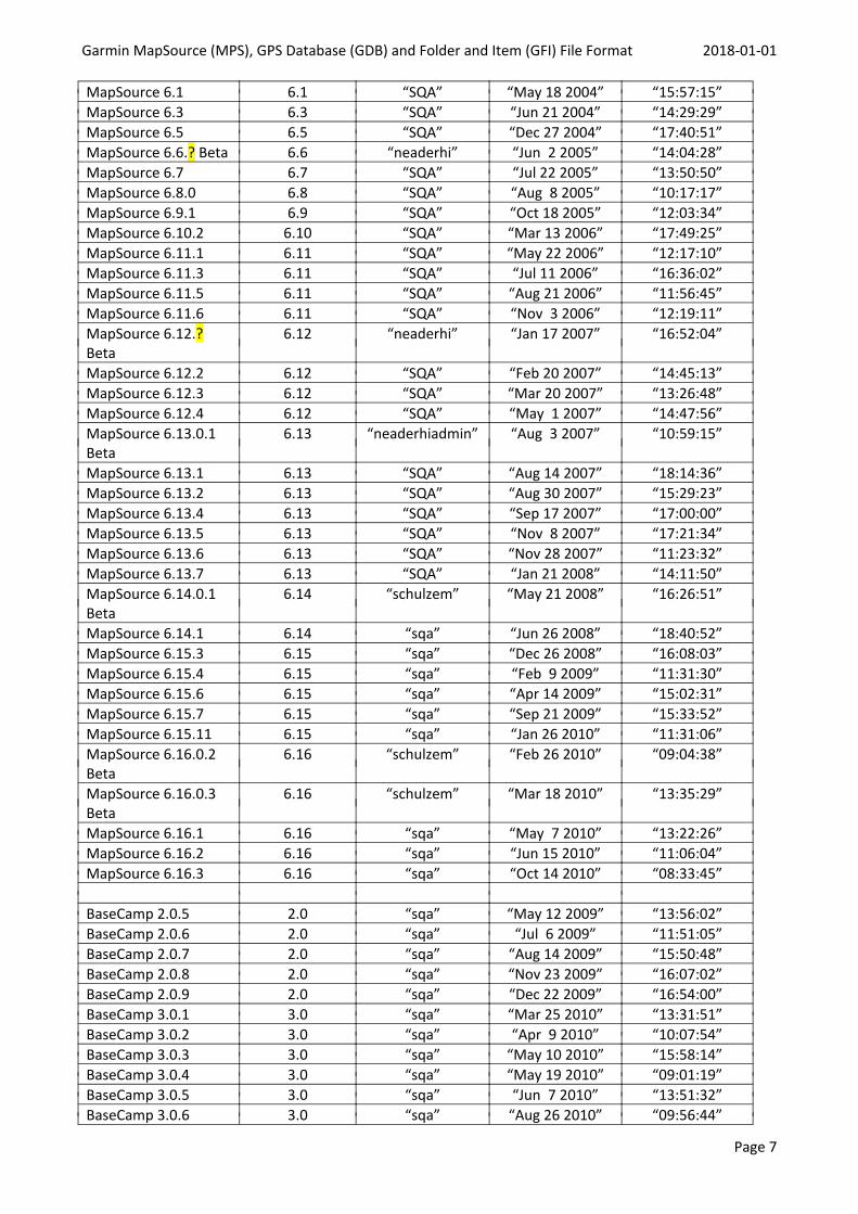
MapSource 6.1 6.1 “SQA” “May 18 2004” “15:57:15”MapSource 6.3 6.3 “SQA” “Jun 21 2004” “14:29:29”MapSource 6.5 6.5 “SQA” “Dec 27 2004” “17:40:51”MapSource 6.6.? Beta 6.6 “neaderhi” “Jun 2 2005” “14:04:28”MapSource 6.7 6.7 “SQA” “Jul 22 2005” “13:50:50”MapSource 6.8.0 6.8 “SQA” “Aug 8 2005” “10:17:17”MapSource 6.9.1 6.9 “SQA” “Oct 18 2005” “12:03:34”MapSource 6.10.2 6.10 “SQA” “Mar 13 2006” “17:49:25”MapSource 6.11.1 6.11 “SQA” “May 22 2006” “12:17:10”MapSource 6.11.3 6.11 “SQA” “Jul 11 2006” “16:36:02”MapSource 6.11.5 6.11 “SQA” “Aug 21 2006” “11:56:45”MapSource 6.11.6 6.11 “SQA” “Nov 3 2006” “12:19:11”MapSource 6.12.?Beta
6.12 “neaderhi” “Jan 17 2007” “16:52:04”
MapSource 6.12.2 6.12 “SQA” “Feb 20 2007” “14:45:13”MapSource 6.12.3 6.12 “SQA” “Mar 20 2007” “13:26:48”MapSource 6.12.4 6.12 “SQA” “May 1 2007” “14:47:56”MapSource 6.13.0.1Beta
6.13 “neaderhiadmin” “Aug 3 2007” “10:59:15”
MapSource 6.13.1 6.13 “SQA” “Aug 14 2007” “18:14:36”MapSource 6.13.2 6.13 “SQA” “Aug 30 2007” “15:29:23”MapSource 6.13.4 6.13 “SQA” “Sep 17 2007” “17:00:00”MapSource 6.13.5 6.13 “SQA” “Nov 8 2007” “17:21:34”MapSource 6.13.6 6.13 “SQA” “Nov 28 2007” “11:23:32”MapSource 6.13.7 6.13 “SQA” “Jan 21 2008” “14:11:50”MapSource 6.14.0.1Beta
6.14 “schulzem” “May 21 2008” “16:26:51”
MapSource 6.14.1 6.14 “sqa” “Jun 26 2008” “18:40:52”MapSource 6.15.3 6.15 “sqa” “Dec 26 2008” “16:08:03”MapSource 6.15.4 6.15 “sqa” “Feb 9 2009” “11:31:30”MapSource 6.15.6 6.15 “sqa” “Apr 14 2009” “15:02:31”MapSource 6.15.7 6.15 “sqa” “Sep 21 2009” “15:33:52”MapSource 6.15.11 6.15 “sqa” “Jan 26 2010” “11:31:06”MapSource 6.16.0.2Beta
6.16 “schulzem” “Feb 26 2010” “09:04:38”
MapSource 6.16.0.3Beta
6.16 “schulzem” “Mar 18 2010” “13:35:29”
MapSource 6.16.1 6.16 “sqa” “May 7 2010” “13:22:26”MapSource 6.16.2 6.16 “sqa” “Jun 15 2010” “11:06:04”MapSource 6.16.3 6.16 “sqa” “Oct 14 2010” “08:33:45”
BaseCamp 2.0.5 2.0 “sqa” “May 12 2009” “13:56:02”BaseCamp 2.0.6 2.0 “sqa” “Jul 6 2009” “11:51:05”BaseCamp 2.0.7 2.0 “sqa” “Aug 14 2009” “15:50:48”BaseCamp 2.0.8 2.0 “sqa” “Nov 23 2009” “16:07:02”BaseCamp 2.0.9 2.0 “sqa” “Dec 22 2009” “16:54:00”BaseCamp 3.0.1 3.0 “sqa” “Mar 25 2010” “13:31:51”BaseCamp 3.0.2 3.0 “sqa” “Apr 9 2010” “10:07:54”BaseCamp 3.0.3 3.0 “sqa” “May 10 2010” “15:58:14”BaseCamp 3.0.4 3.0 “sqa” “May 19 2010” “09:01:19”BaseCamp 3.0.5 3.0 “sqa” “Jun 7 2010” “13:51:32”BaseCamp 3.0.6 3.0 “sqa” “Aug 26 2010” “09:56:44”
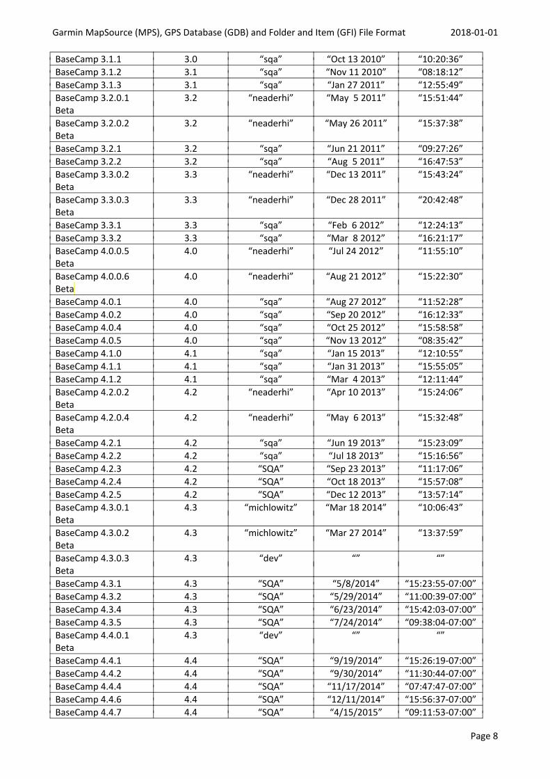
Garmin MapSource (MPS), GPS Database (GDB) and Folder and Item (GFI) File Format 2018-01-01
Page 8
BaseCamp 3.1.1 3.0 “sqa” “Oct 13 2010” “10:20:36”BaseCamp 3.1.2 3.1 “sqa” “Nov 11 2010” “08:18:12”BaseCamp 3.1.3 3.1 “sqa” “Jan 27 2011” “12:55:49”BaseCamp 3.2.0.1Beta
3.2 “neaderhi” “May 5 2011” “15:51:44”
BaseCamp 3.2.0.2Beta
3.2 “neaderhi” “May 26 2011” “15:37:38”
BaseCamp 3.2.1 3.2 “sqa” “Jun 21 2011” “09:27:26”BaseCamp 3.2.2 3.2 “sqa” “Aug 5 2011” “16:47:53”BaseCamp 3.3.0.2Beta
3.3 “neaderhi” “Dec 13 2011” “15:43:24”
BaseCamp 3.3.0.3Beta
3.3 “neaderhi” “Dec 28 2011” “20:42:48”
BaseCamp 3.3.1 3.3 “sqa” “Feb 6 2012” “12:24:13”BaseCamp 3.3.2 3.3 “sqa” “Mar 8 2012” “16:21:17”BaseCamp 4.0.0.5Beta
4.0 “neaderhi” “Jul 24 2012” “11:55:10”
BaseCamp 4.0.0.6Beta
4.0 “neaderhi” “Aug 21 2012” “15:22:30”
BaseCamp 4.0.1 4.0 “sqa” “Aug 27 2012” “11:52:28”BaseCamp 4.0.2 4.0 “sqa” “Sep 20 2012” “16:12:33”BaseCamp 4.0.4 4.0 “sqa” “Oct 25 2012” “15:58:58”BaseCamp 4.0.5 4.0 “sqa” “Nov 13 2012” “08:35:42”BaseCamp 4.1.0 4.1 “sqa” “Jan 15 2013” “12:10:55”BaseCamp 4.1.1 4.1 “sqa” “Jan 31 2013” “15:55:05”BaseCamp 4.1.2 4.1 “sqa” “Mar 4 2013” “12:11:44”BaseCamp 4.2.0.2Beta
4.2 “neaderhi” “Apr 10 2013” “15:24:06”
BaseCamp 4.2.0.4Beta
4.2 “neaderhi” “May 6 2013” “15:32:48”
BaseCamp 4.2.1 4.2 “sqa” “Jun 19 2013” “15:23:09”BaseCamp 4.2.2 4.2 “sqa” “Jul 18 2013” “15:16:56”BaseCamp 4.2.3 4.2 “SQA” “Sep 23 2013” “11:17:06”BaseCamp 4.2.4 4.2 “SQA” “Oct 18 2013” “15:57:08”BaseCamp 4.2.5 4.2 “SQA” “Dec 12 2013” “13:57:14”BaseCamp 4.3.0.1Beta
4.3 “michlowitz” “Mar 18 2014” “10:06:43”
BaseCamp 4.3.0.2Beta
4.3 “michlowitz” “Mar 27 2014” “13:37:59”
BaseCamp 4.3.0.3Beta
4.3 “dev” “” “”
BaseCamp 4.3.1 4.3 “SQA” “5/8/2014” “15:23:55-07:00”BaseCamp 4.3.2 4.3 “SQA” “5/29/2014” “11:00:39-07:00”BaseCamp 4.3.4 4.3 “SQA” “6/23/2014” “15:42:03-07:00”BaseCamp 4.3.5 4.3 “SQA” “7/24/2014” “09:38:04-07:00”BaseCamp 4.4.0.1Beta
4.3 “dev” “” “”
BaseCamp 4.4.1 4.4 “SQA” “9/19/2014” “15:26:19-07:00”BaseCamp 4.4.2 4.4 “SQA” “9/30/2014” “11:30:44-07:00”BaseCamp 4.4.4 4.4 “SQA” “11/17/2014” “07:47:47-07:00”BaseCamp 4.4.6 4.4 “SQA” “12/11/2014” “15:56:37-07:00”BaseCamp 4.4.7 4.4 “SQA” “4/15/2015” “09:11:53-07:00”
Garmin MapSource (MPS), GPS Database (GDB) and Folder and Item (GFI) File Format 2018-01-01
Page 9
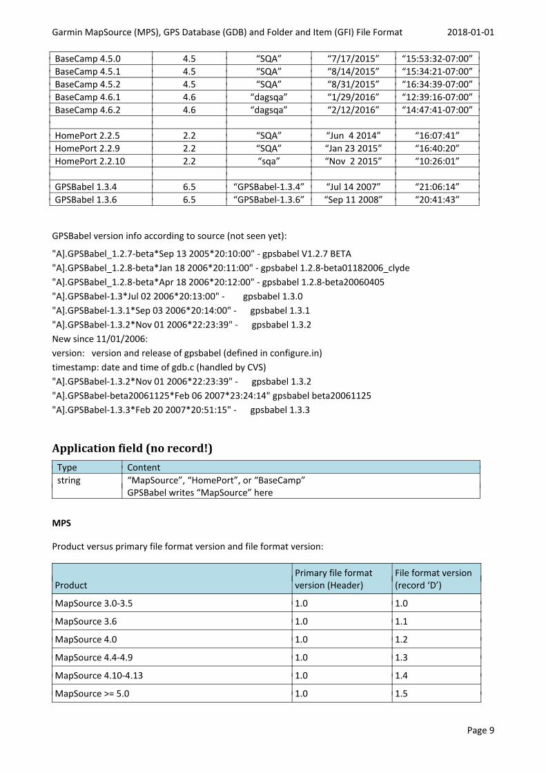
BaseCamp 4.5.0 4.5 “SQA” “7/17/2015” “15:53:32-07:00”BaseCamp 4.5.1 4.5 “SQA” “8/14/2015” “15:34:21-07:00”BaseCamp 4.5.2 4.5 “SQA” “8/31/2015” “16:34:39-07:00”BaseCamp 4.6.1 4.6 “dagsqa” “1/29/2016” “12:39:16-07:00”BaseCamp 4.6.2 4.6 “dagsqa” “2/12/2016” “14:47:41-07:00”
HomePort 2.2.5 2.2 “SQA” “Jun 4 2014” “16:07:41”HomePort 2.2.9 2.2 “SQA” “Jan 23 2015” “16:40:20”HomePort 2.2.10 2.2 “sqa” “Nov 2 2015” “10:26:01”
GPSBabel 1.3.4 6.5 “GPSBabel-1.3.4” “Jul 14 2007” “21:06:14”GPSBabel 1.3.6 6.5 “GPSBabel-1.3.6” “Sep 11 2008” “20:41:43”
GPSBabel version info according to source (not seen yet):
"A].GPSBabel_1.2.7-beta*Sep 13 2005*20:10:00" - gpsbabel V1.2.7 BETA"A].GPSBabel_1.2.8-beta*Jan 18 2006*20:11:00" - gpsbabel 1.2.8-beta01182006_clyde"A].GPSBabel_1.2.8-beta*Apr 18 2006*20:12:00" - gpsbabel 1.2.8-beta20060405"A].GPSBabel-1.3*Jul 02 2006*20:13:00" - gpsbabel 1.3.0"A].GPSBabel-1.3.1*Sep 03 2006*20:14:00" - gpsbabel 1.3.1"A].GPSBabel-1.3.2*Nov 01 2006*22:23:39" - gpsbabel 1.3.2New since 11/01/2006:version: version and release of gpsbabel (defined in configure.in)timestamp: date and time of gdb.c (handled by CVS)"A].GPSBabel-1.3.2*Nov 01 2006*22:23:39" - gpsbabel 1.3.2"A].GPSBabel-beta20061125*Feb 06 2007*23:24:14" gpsbabel beta20061125"A].GPSBabel-1.3.3*Feb 20 2007*20:51:15" - gpsbabel 1.3.3
Application field (no record!)Type Contentstring “MapSource”, “HomePort”, or “BaseCamp”
GPSBabel writes “MapSource” here
MPS
Product versus primary file format version and file format version:
ProductPrimary file formatversion (Header)
File format version(record ‘D’)
MapSource 3.0-3.5 1.0 1.0
MapSource 3.6 1.0 1.1
MapSource 4.0 1.0 1.2
MapSource 4.4-4.9 1.0 1.3
MapSource 4.10-4.13 1.0 1.4
MapSource >= 5.0 1.0 1.5
Garmin MapSource (MPS), GPS Database (GDB) and Folder and Item (GFI) File Format 2018-01-01
Page 10
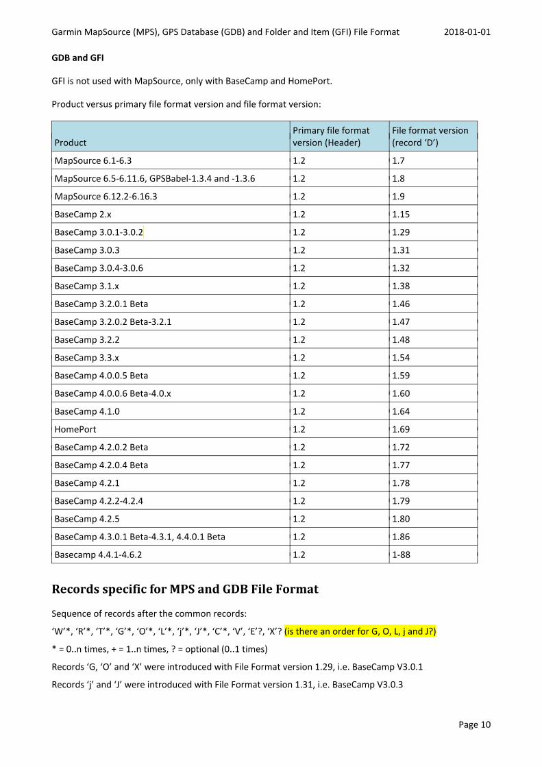
GDB and GFI
GFI is not used with MapSource, only with BaseCamp and HomePort.
Product versus primary file format version and file format version:
ProductPrimary file formatversion (Header)
File format version(record ‘D’)
MapSource 6.1-6.3 1.2 1.7
MapSource 6.5-6.11.6, GPSBabel-1.3.4 and -1.3.6 1.2 1.8
MapSource 6.12.2-6.16.3 1.2 1.9
BaseCamp 2.x 1.2 1.15
BaseCamp 3.0.1-3.0.2 1.2 1.29
BaseCamp 3.0.3 1.2 1.31
BaseCamp 3.0.4-3.0.6 1.2 1.32
BaseCamp 3.1.x 1.2 1.38
BaseCamp 3.2.0.1 Beta 1.2 1.46
BaseCamp 3.2.0.2 Beta-3.2.1 1.2 1.47
BaseCamp 3.2.2 1.2 1.48
BaseCamp 3.3.x 1.2 1.54
BaseCamp 4.0.0.5 Beta 1.2 1.59
BaseCamp 4.0.0.6 Beta-4.0.x 1.2 1.60
BaseCamp 4.1.0 1.2 1.64
HomePort 1.2 1.69
BaseCamp 4.2.0.2 Beta 1.2 1.72
BaseCamp 4.2.0.4 Beta 1.2 1.77
BaseCamp 4.2.1 1.2 1.78
BaseCamp 4.2.2-4.2.4 1.2 1.79
BaseCamp 4.2.5 1.2 1.80
BaseCamp 4.3.0.1 Beta-4.3.1, 4.4.0.1 Beta 1.2 1.86
Basecamp 4.4.1-4.6.2 1.2 1-88
Records specific for MPS and GDB File Format
Sequence of records after the common records:
‘W’*, ‘R’*, ‘T’*, ‘G’*, ‘O’*, ‘L’*, ‘j’*, ‘J’*, ‘C’*, ‘V’, ‘E’?, ‘X’? (is there an order for G, O, L, j and J?)
* = 0..n times, + = 1..n times, ? = optional (0..1 times)
Records ‘G, ‘O’ and ‘X’ were introduced with File Format version 1.29, i.e. BaseCamp V3.0.1
Records ‘j’ and ‘J’ were introduced with File Format version 1.31, i.e. BaseCamp V3.0.3
Garmin MapSource (MPS), GPS Database (GDB) and Folder and Item (GFI) File Format 2018-01-01
Page 11
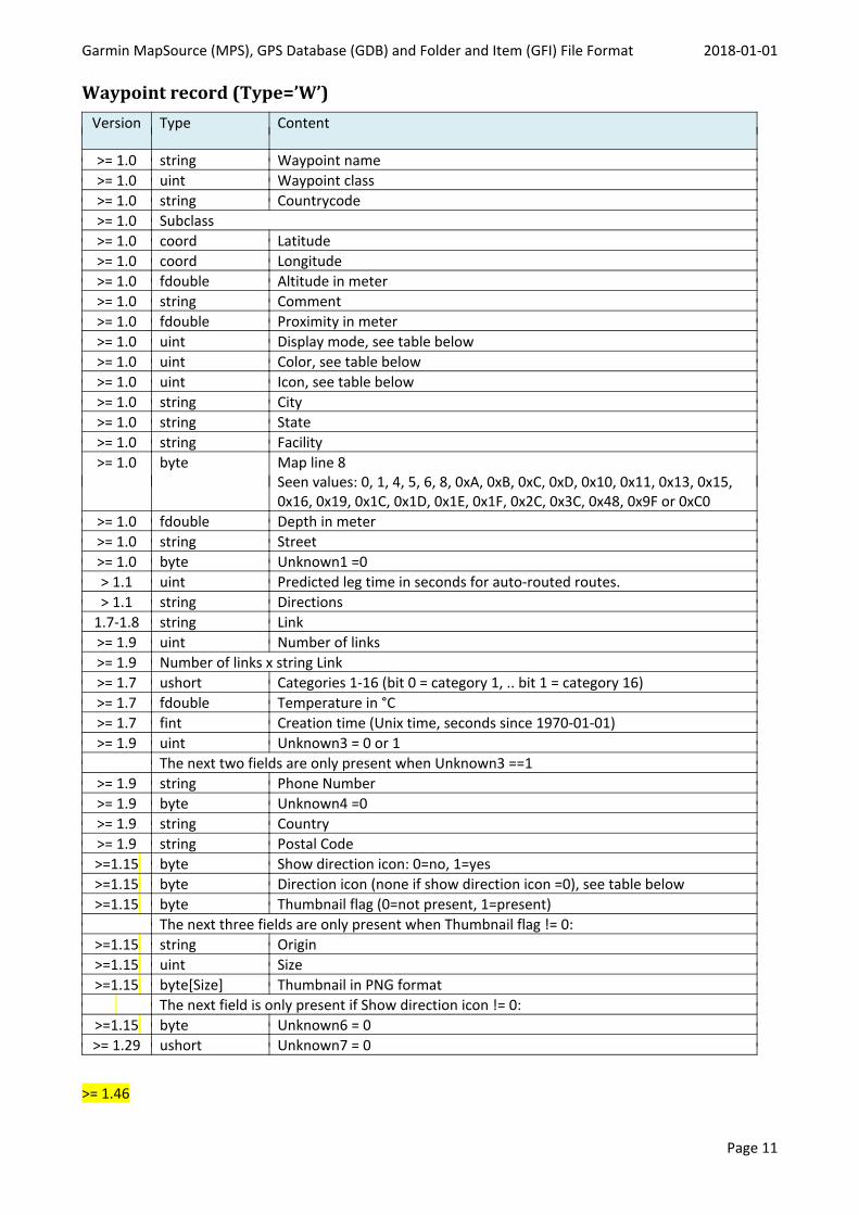
Waypoint record (Type=’W’)Version Type Content
>= 1.0 string Waypoint name>= 1.0 uint Waypoint class>= 1.0 string Countrycode>= 1.0 Subclass>= 1.0 coord Latitude>= 1.0 coord Longitude>= 1.0 fdouble Altitude in meter>= 1.0 string Comment>= 1.0 fdouble Proximity in meter>= 1.0 uint Display mode, see table below>= 1.0 uint Color, see table below>= 1.0 uint Icon, see table below>= 1.0 string City>= 1.0 string State>= 1.0 string Facility>= 1.0 byte Map line 8
Seen values: 0, 1, 4, 5, 6, 8, 0xA, 0xB, 0xC, 0xD, 0x10, 0x11, 0x13, 0x15,0x16, 0x19, 0x1C, 0x1D, 0x1E, 0x1F, 0x2C, 0x3C, 0x48, 0x9F or 0xC0
>= 1.0 fdouble Depth in meter>= 1.0 string Street>= 1.0 byte Unknown1 =0> 1.1 uint Predicted leg time in seconds for auto-routed routes.> 1.1 string Directions
1.7-1.8 string Link>= 1.9 uint Number of links>= 1.9 Number of links x string Link>= 1.7 ushort Categories 1-16 (bit 0 = category 1, .. bit 1 = category 16)>= 1.7 fdouble Temperature in °C>= 1.7 fint Creation time (Unix time, seconds since 1970-01-01)>= 1.9 uint Unknown3 = 0 or 1
The next two fields are only present when Unknown3 ==1>= 1.9 string Phone Number>= 1.9 byte Unknown4 =0>= 1.9 string Country>= 1.9 string Postal Code>=1.15 byte Show direction icon: 0=no, 1=yes>=1.15 byte Direction icon (none if show direction icon =0), see table below>=1.15 byte Thumbnail flag (0=not present, 1=present)
The next three fields are only present when Thumbnail flag != 0:>=1.15 string Origin>=1.15 uint Size>=1.15 byte[Size] Thumbnail in PNG format
The next field is only present if Show direction icon != 0:>=1.15 byte Unknown6 = 0>= 1.29 ushort Unknown7 = 0
>= 1.46
Garmin MapSource (MPS), GPS Database (GDB) and Folder and Item (GFI) File Format 2018-01-01
Page 12
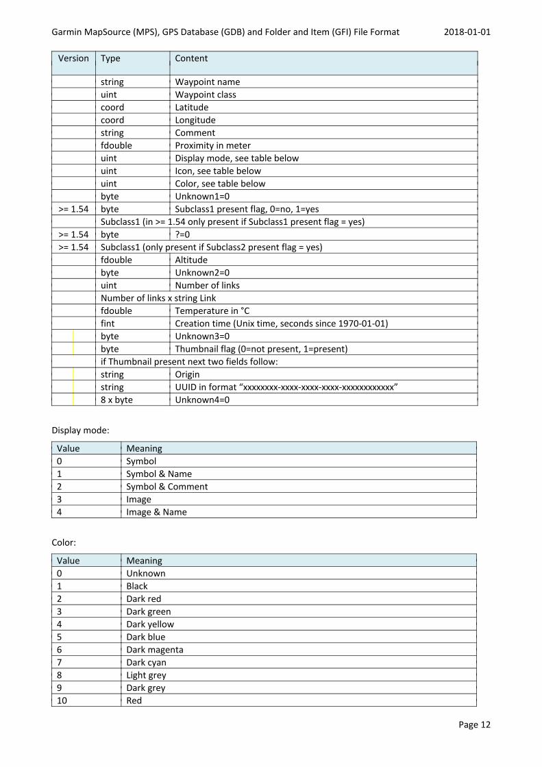
Version Type Content
string Waypoint nameuint Waypoint classcoord Latitudecoord Longitudestring Commentfdouble Proximity in meteruint Display mode, see table belowuint Icon, see table belowuint Color, see table belowbyte Unknown1=0
>= 1.54 byte Subclass1 present flag, 0=no, 1=yesSubclass1 (in >= 1.54 only present if Subclass1 present flag = yes)
>= 1.54 byte ?=0>= 1.54 Subclass1 (only present if Subclass2 present flag = yes)
fdouble Altitudebyte Unknown2=0uint Number of linksNumber of links x string Linkfdouble Temperature in °Cfint Creation time (Unix time, seconds since 1970-01-01)byte Unknown3=0byte Thumbnail flag (0=not present, 1=present)if Thumbnail present next two fields follow:string Originstring UUID in format “xxxxxxxx-xxxx-xxxx-xxxx-xxxxxxxxxxxx”8 x byte Unknown4=0
Display mode:
Value Meaning0 Symbol1 Symbol & Name2 Symbol & Comment3 Image4 Image & Name
Color:
Value Meaning0 Unknown1 Black2 Dark red3 Dark green4 Dark yellow5 Dark blue6 Dark magenta7 Dark cyan8 Light grey9 Dark grey10 Red
Garmin MapSource (MPS), GPS Database (GDB) and Folder and Item (GFI) File Format 2018-01-01
Page 13
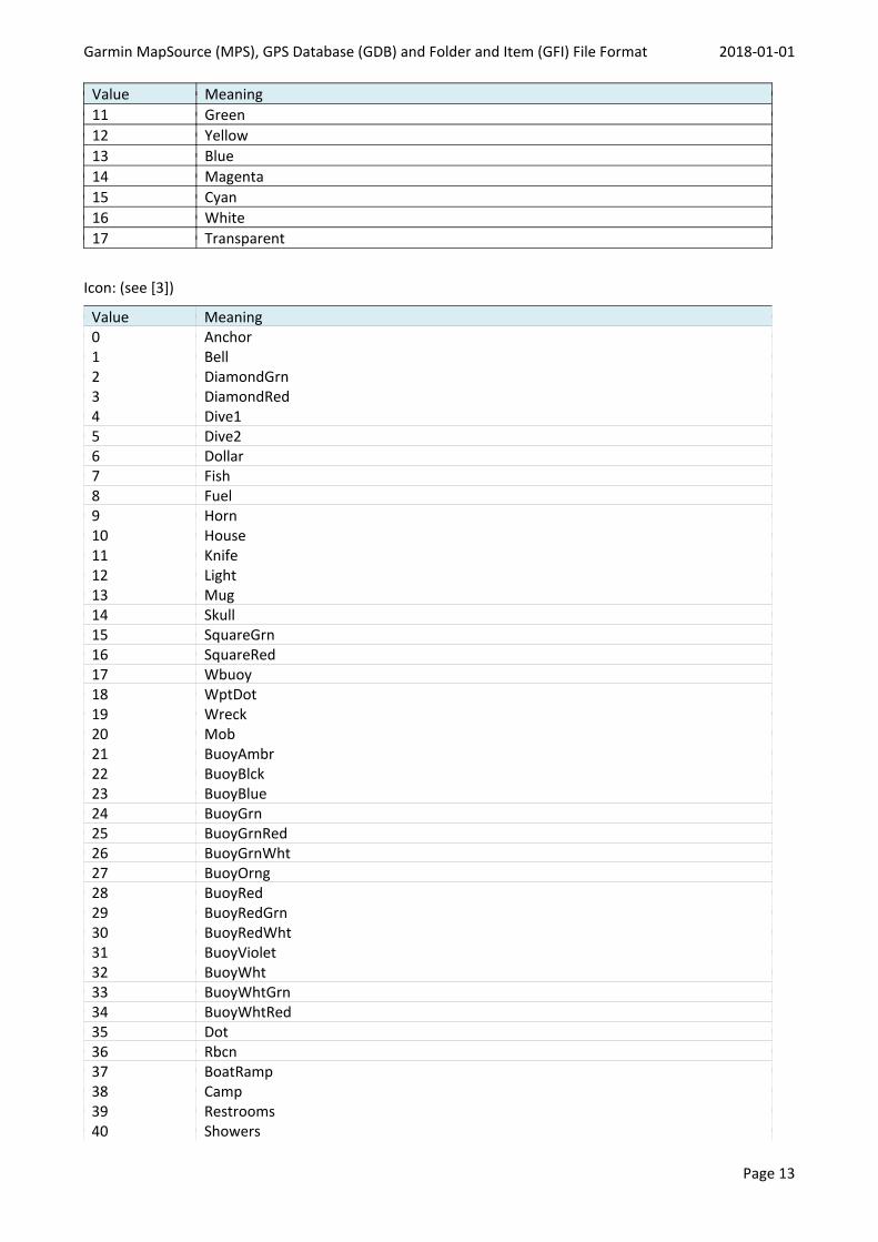
Value Meaning11 Green12 Yellow13 Blue14 Magenta15 Cyan16 White17 Transparent
Icon: (see [3])
Value Meaning0 Anchor1 Bell2 DiamondGrn3 DiamondRed4 Dive15 Dive26 Dollar7 Fish8 Fuel9 Horn10 House11 Knife12 Light13 Mug14 Skull15 SquareGrn16 SquareRed17 Wbuoy18 WptDot19 Wreck20 Mob21 BuoyAmbr22 BuoyBlck23 BuoyBlue24 BuoyGrn25 BuoyGrnRed26 BuoyGrnWht27 BuoyOrng28 BuoyRed29 BuoyRedGrn30 BuoyRedWht31 BuoyViolet32 BuoyWht33 BuoyWhtGrn34 BuoyWhtRed35 Dot36 Rbcn37 BoatRamp38 Camp39 Restrooms40 Showers
Garmin MapSource (MPS), GPS Database (GDB) and Folder and Item (GFI) File Format 2018-01-01
Page 14
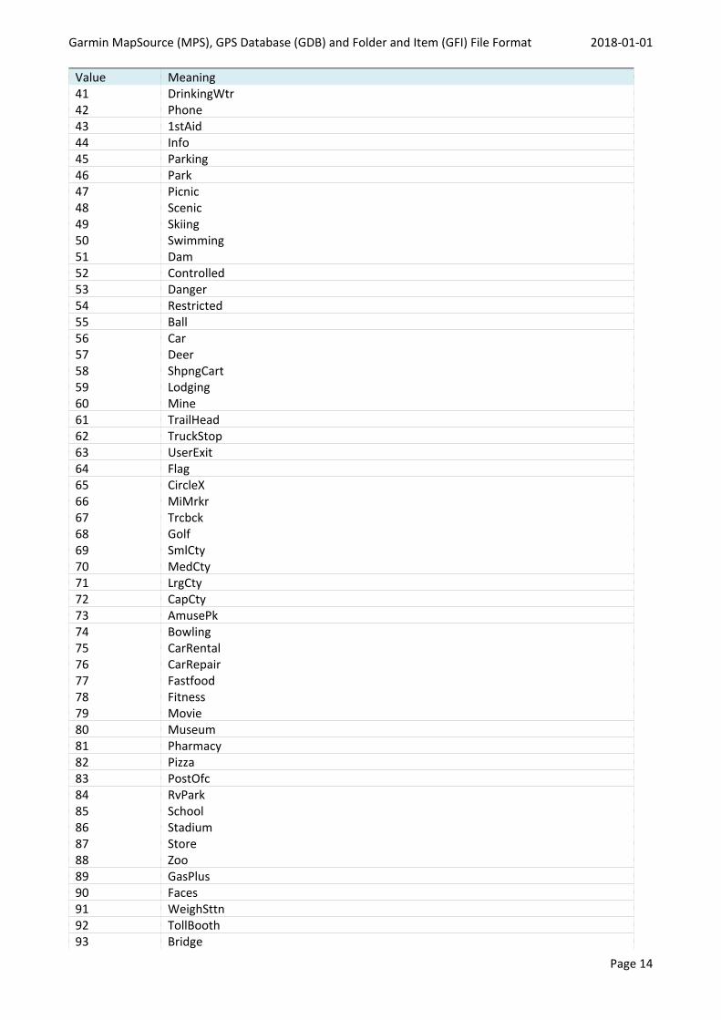
Value Meaning41 DrinkingWtr42 Phone43 1stAid44 Info45 Parking46 Park47 Picnic48 Scenic49 Skiing50 Swimming51 Dam52 Controlled53 Danger54 Restricted55 Ball56 Car57 Deer58 ShpngCart59 Lodging60 Mine61 TrailHead62 TruckStop63 UserExit64 Flag65 CircleX66 MiMrkr67 Trcbck68 Golf69 SmlCty70 MedCty71 LrgCty72 CapCty73 AmusePk74 Bowling75 CarRental76 CarRepair77 Fastfood78 Fitness79 Movie80 Museum81 Pharmacy82 Pizza83 PostOfc84 RvPark85 School86 Stadium87 Store88 Zoo89 GasPlus90 Faces91 WeighSttn92 TollBooth93 Bridge
Garmin MapSource (MPS), GPS Database (GDB) and Folder and Item (GFI) File Format 2018-01-01
Page 15
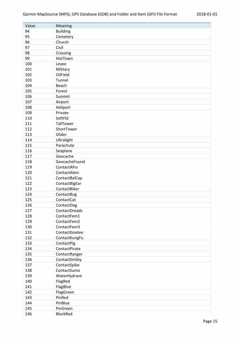
Value Meaning94 Building95 Cemetery96 Church97 Civil98 Crossing99 HistTown100 Levee101 Military102 OilField103 Tunnel104 Beach105 Forest106 Summit107 Airport108 Heliport109 Private110 SoftFld111 TallTower112 ShortTower113 Glider114 Ultralight115 Parachute116 Seaplane117 Geocache118 GeocacheFound119 ContactAfro120 ContactAlien121 ContactBalCap122 ContactBigEar123 ContactBiker124 ContactBug125 ContactCat126 ContactDog127 ContactDreads128 ContactFem1129 ContactFem2130 ContactFem3131 ContactGoatee132 ContactKungFu133 ContactPig134 ContactPirate135 ContactRanger136 ContactSmiley137 ContactSpike138 ContactSumo139 WaterHydrant140 FlagRed141 FlagBlue142 FlagGreen143 PinRed144 PinBlue145 PinGreen146 BlockRed
Garmin MapSource (MPS), GPS Database (GDB) and Folder and Item (GFI) File Format 2018-01-01
Page 16
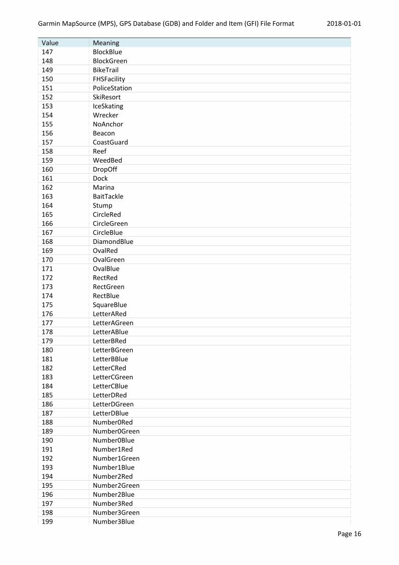
Value Meaning147 BlockBlue148 BlockGreen149 BikeTrail150 FHSFacility151 PoliceStation152 SkiResort153 IceSkating154 Wrecker155 NoAnchor156 Beacon157 CoastGuard158 Reef159 WeedBed160 DropOff161 Dock162 Marina163 BaitTackle164 Stump165 CircleRed166 CircleGreen167 CircleBlue168 DiamondBlue169 OvalRed170 OvalGreen171 OvalBlue172 RectRed173 RectGreen174 RectBlue175 SquareBlue176 LetterARed177 LetterAGreen178 LetterABlue179 LetterBRed180 LetterBGreen181 LetterBBlue182 LetterCRed183 LetterCGreen184 LetterCBlue185 LetterDRed186 LetterDGreen187 LetterDBlue188 Number0Red189 Number0Green190 Number0Blue191 Number1Red192 Number1Green193 Number1Blue194 Number2Red195 Number2Green196 Number2Blue197 Number3Red198 Number3Green199 Number3Blue
Garmin MapSource (MPS), GPS Database (GDB) and Folder and Item (GFI) File Format 2018-01-01
Page 17
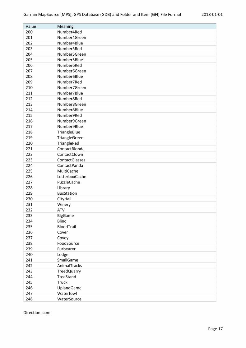
Value Meaning200 Number4Red201 Number4Green202 Number4Blue203 Number5Red204 Number5Green205 Number5Blue206 Number6Red207 Number6Green208 Number6Blue209 Number7Red210 Number7Green211 Number7Blue212 Number8Red213 Number8Green214 Number8Blue215 Number9Red216 Number9Green217 Number9Blue218 TriangleBlue219 TriangleGreen220 TriangleRed221 ContactBlonde222 ContactClown223 ContactGlasses224 ContactPanda225 MultiCache226 LetterboxCache227 PuzzleCache228 Library229 BusStation230 CityHall231 Winery232 ATV233 BigGame234 Blind235 BloodTrail236 Cover237 Covey238 FoodSource239 Furbearer240 Lodge241 SmallGame242 AnimalTracks243 TreedQuarry244 TreeStand245 Truck246 UplandGame247 Waterfowl248 WaterSource
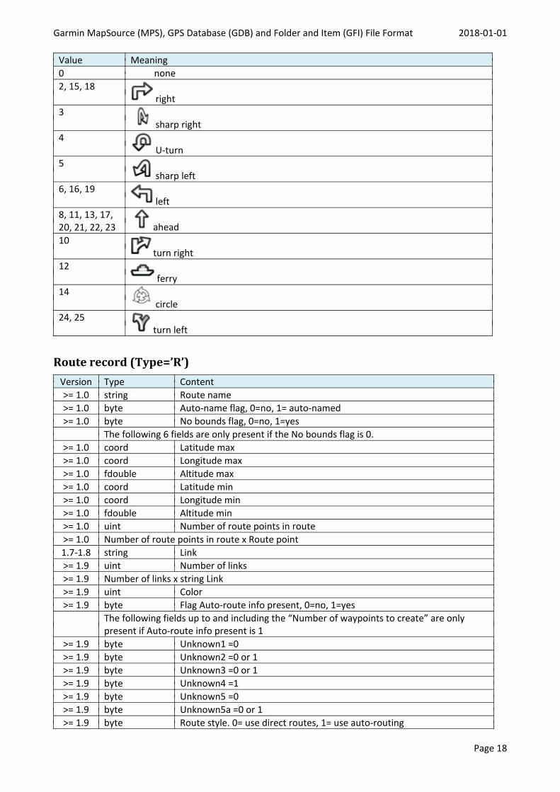
Direction icon:
Garmin MapSource (MPS), GPS Database (GDB) and Folder and Item (GFI) File Format 2018-01-01
Page 18
Value Meaning0 none2, 15, 18
right3
sharp right4
U-turn5
sharp left6, 16, 19
left8, 11, 13, 17,20, 21, 22, 23 ahead10
turn right12
ferry14
circle24, 25
turn left
Route record (Type=’R’)Version Type Content>= 1.0 string Route name>= 1.0 byte Auto-name flag, 0=no, 1= auto-named>= 1.0 byte No bounds flag, 0=no, 1=yes
The following 6 fields are only present if the No bounds flag is 0.>= 1.0 coord Latitude max>= 1.0 coord Longitude max>= 1.0 fdouble Altitude max>= 1.0 coord Latitude min>= 1.0 coord Longitude min>= 1.0 fdouble Altitude min>= 1.0 uint Number of route points in route>= 1.0 Number of route points in route x Route point1.7-1.8 string Link>= 1.9 uint Number of links>= 1.9 Number of links x string Link>= 1.9 uint Color>= 1.9 byte Flag Auto-route info present, 0=no, 1=yes
The following fields up to and including the “Number of waypoints to create” are onlypresent if Auto-route info present is 1
>= 1.9 byte Unknown1 =0>= 1.9 byte Unknown2 =0 or 1>= 1.9 byte Unknown3 =0 or 1>= 1.9 byte Unknown4 =1>= 1.9 byte Unknown5 =0>= 1.9 byte Unknown5a =0 or 1>= 1.9 byte Route style. 0= use direct routes, 1= use auto-routing
Garmin MapSource (MPS), GPS Database (GDB) and Folder and Item (GFI) File Format 2018-01-01
Page 19
Version Type Content>= 1.9 uint Calculation type, 0=Faster time, 1=Shorter distance>= 1.9 byte Vehicle type, see table below>= 1.9 uint Road selection: -3 (minor roads) to 3 (highways)>= 1.9 double Average driving speed for residential street, in 1/10 meter per second>= 1.9 double Average driving speed for collector road, in 1/10 meter per second>= 1.9 double Average driving speed for other highway, in 1/10 meter per second>= 1.9 double Average driving speed for major highway, in 1/10 meter per second>= 1.9 double Average driving speed for interstate highway, in 1/10 meter per second>= 1.9 byte[8] Unknown6 =0
>= 1.15 uint Unknown7 =1>= 1.15 double Distance between waypoints>= 1.15 uint Unknown8 =0>= 1.15 uint Number of waypoints to create>= 1.9 string Notes (may be empty)
>= 1.15 byte Flag “is filtered route”. 0= no, 1= yes>= 1.15 uint Number of filtered points
Number of filtered points x Link point>= 1.15 byte Unknown9 Flag ? If 1, nothing follows. Else if 0, the next two fields
follow:>= 1.15 Link point ?>= 1.15 Link point ?>= 1.29 byte Unknown10 =0
>= 1.46
Version Type Contentstring Route namebyte Auto-name flag, 0=no, 1= auto-nameduint Number of route points in routeNumber of route points in route x Route point…
Nach Route points (d.h. da fehlt einiges!):
1 Byte =0 unknown9 Flag
2 Link Points
uint 0 könnte Anzahl Links sein
uint 14 könnte Color sein
irgendwo hier +/- 1-2 byte beginnt die Auto-Route info
uint 1
byte 1 1 1 1
usw. double Geschwindigkeiten
Flag filtered, number of filtered points, points
Route point:
Version Type Content>= 1.0 string Point name
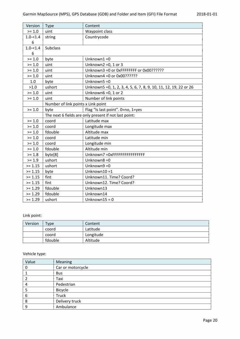
Garmin MapSource (MPS), GPS Database (GDB) and Folder and Item (GFI) File Format 2018-01-01
Page 20
Version Type Content>= 1.0 uint Waypoint class
1.0-<1.46
string Countrycode
1.0-<1.46
Subclass
>= 1.0 byte Unknown1 =0>= 1.0 uint Unknown2 =0, 1 or 3>= 1.0 uint Unknown3 =0 or 0xFFFFFFFF or 0x00??????>= 1.0 uint Unknown4 =0 or 0x00??????
1.0 byte Unknown5 =0>1.0 ushort Unknown5 =0, 1, 2, 3, 4, 5, 6, 7, 8, 9, 10, 11, 12, 19, 22 or 26
>= 1.0 uint Unknown6 =0, 1 or 2>= 1.0 uint Number of link points
Number of link points x Link point>= 1.0 byte Flag “Is last point”. 0=no, 1=yes
The next 6 fields are only present if not last point:>= 1.0 coord Latitude max>= 1.0 coord Longitude max>= 1.0 fdouble Altitude max>= 1.0 coord Latitude min>= 1.0 coord Longitude min>= 1.0 fdouble Altitude min>= 1.8 byte[8] Unknown7 =0xFFFFFFFFFFFFFFFF>= 1.9 ushort Unknown8 =0
>= 1.15 ushort Unknown9 =0>= 1.15 byte Unknown10 =1>= 1.15 fint Unknown11. Time? Coord?>= 1.15 fint Unknown12. Time? Coord?>= 1.29 fdouble Unknown13>= 1.29 fdouble Unknown14>= 1.29 ushort Unknown15 = 0
Link point:
Version Type Contentcoord Latitudecoord Longitudefdouble Altitude
Vehicle type:
Value Meaning0 Car or motorcycle1 Bus2 Taxi4 Pedestrian5 Bicycle6 Truck8 Delivery truck9 Ambulance
Garmin MapSource (MPS), GPS Database (GDB) and Folder and Item (GFI) File Format 2018-01-01
Page 21
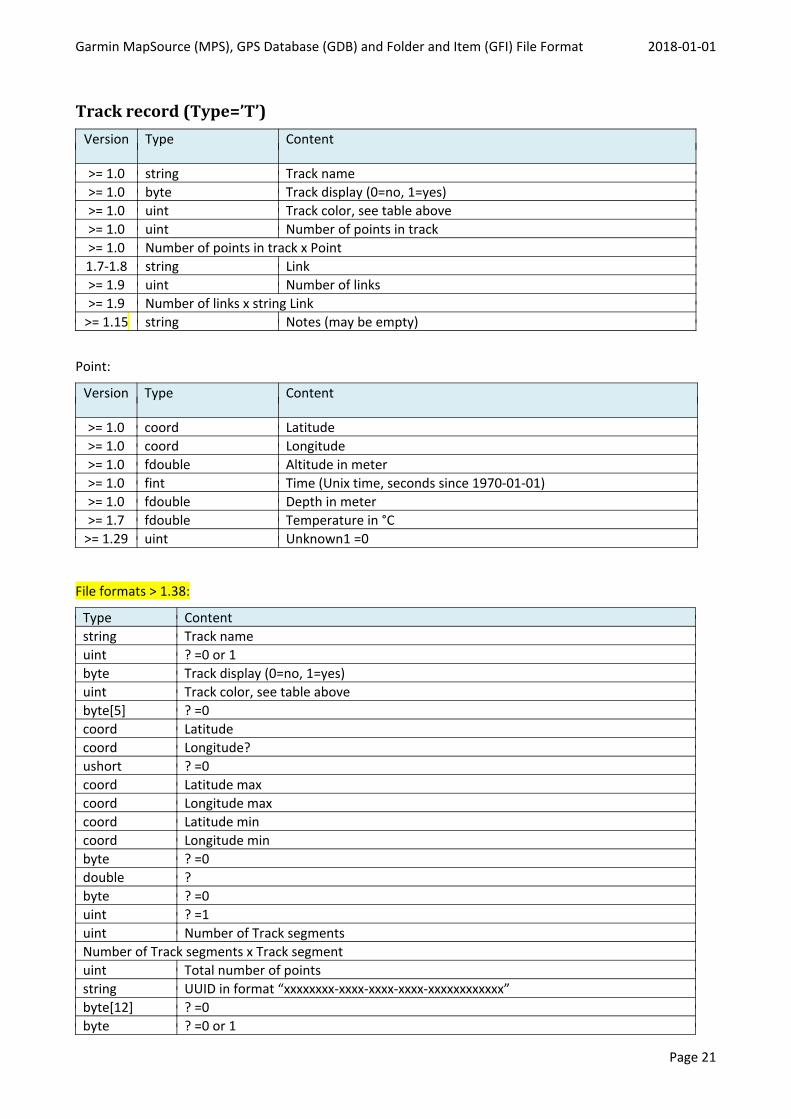
Track record (Type=’T’)Version Type Content
>= 1.0 string Track name>= 1.0 byte Track display (0=no, 1=yes)>= 1.0 uint Track color, see table above>= 1.0 uint Number of points in track>= 1.0 Number of points in track x Point1.7-1.8 string Link>= 1.9 uint Number of links>= 1.9 Number of links x string Link
>= 1.15 string Notes (may be empty)
Point:
Version Type Content
>= 1.0 coord Latitude>= 1.0 coord Longitude>= 1.0 fdouble Altitude in meter>= 1.0 fint Time (Unix time, seconds since 1970-01-01)>= 1.0 fdouble Depth in meter>= 1.7 fdouble Temperature in °C
>= 1.29 uint Unknown1 =0
File formats > 1.38:
Type Contentstring Track nameuint ? =0 or 1byte Track display (0=no, 1=yes)uint Track color, see table abovebyte[5] ? =0coord Latitudecoord Longitude?ushort ? =0coord Latitude maxcoord Longitude maxcoord Latitude mincoord Longitude minbyte ? =0double ?byte ? =0uint ? =1uint Number of Track segmentsNumber of Track segments x Track segmentuint Total number of pointsstring UUID in format “xxxxxxxx-xxxx-xxxx-xxxx-xxxxxxxxxxxx”byte[12] ? =0byte ? =0 or 1
Garmin MapSource (MPS), GPS Database (GDB) and Folder and Item (GFI) File Format 2018-01-01
Page 22
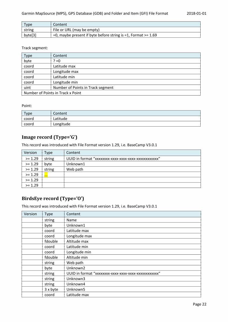
Type Contentstring File or URL (may be empty)byte[3] =0, maybe present if byte before string is =1, Format >= 1.69
Track segment:
Type Contentbyte ? =0coord Latitude maxcoord Longitude maxcoord Latitude mincoord Longitude minuint Number of Points in Track segmentNumber of Points in Track x Point
Point:
Type Contentcoord Latitudecoord Longitude
Image record (Type=’G’)This record was introduced with File Format version 1.29, i.e. BaseCamp V3.0.1
Version Type Content>= 1.29 string UUID in format “xxxxxxxx-xxxx-xxxx-xxxx-xxxxxxxxxxxx”>= 1.29 byte Unknown1>= 1.29 string Web path>= 1.29 ...>= 1.29>= 1.29
BirdsEye record (Type=’O’)This record was introduced with File Format version 1.29, i.e. BaseCamp V3.0.1
Version Type Contentstring Namebyte Unknown1coord Latitude maxcoord Longitude maxfdouble Altitude maxcoord Latitude mincoord Longitude minfdouble Altitude minstring Web pathbyte Unknown2string UUID in format “xxxxxxxx-xxxx-xxxx-xxxx-xxxxxxxxxxxx”string Unknown3string Unknown43 x byte Unknown5coord Latitude max
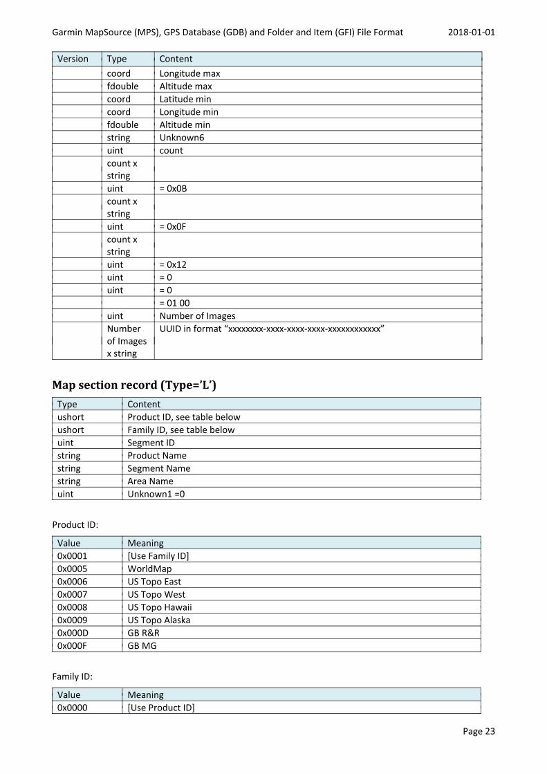
Garmin MapSource (MPS), GPS Database (GDB) and Folder and Item (GFI) File Format 2018-01-01
Page 23
Version Type Contentcoord Longitude maxfdouble Altitude maxcoord Latitude mincoord Longitude minfdouble Altitude minstring Unknown6uint countcount xstringuint = 0x0Bcount xstringuint = 0x0Fcount xstringuint = 0x12uint = 0uint = 0
= 01 00uint Number of ImagesNumberof Imagesx string
UUID in format “xxxxxxxx-xxxx-xxxx-xxxx-xxxxxxxxxxxx”
Map section record (Type=’L’)Type Contentushort Product ID, see table belowushort Family ID, see table belowuint Segment IDstring Product Namestring Segment Namestring Area Nameuint Unknown1 =0
Product ID:
Value Meaning0x0001 [Use Family ID]0x0005 WorldMap0x0006 US Topo East0x0007 US Topo West0x0008 US Topo Hawaii0x0009 US Topo Alaska0x000D GB R&R0x000F GB MG
Family ID:
Value Meaning0x0000 [Use Product ID]
Garmin MapSource (MPS), GPS Database (GDB) and Folder and Item (GFI) File Format 2018-01-01
Page 24
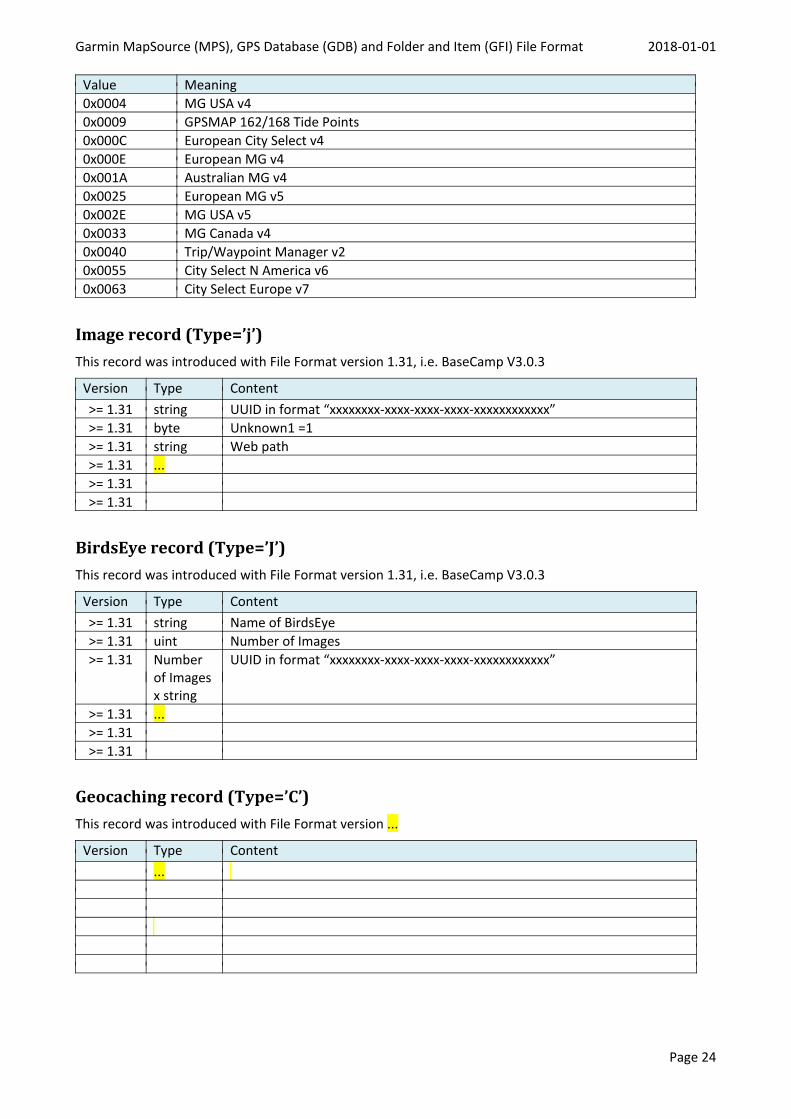
Value Meaning0x0004 MG USA v40x0009 GPSMAP 162/168 Tide Points0x000C European City Select v40x000E European MG v40x001A Australian MG v40x0025 European MG v50x002E MG USA v50x0033 MG Canada v40x0040 Trip/Waypoint Manager v20x0055 City Select N America v60x0063 City Select Europe v7
Image record (Type=’j’)This record was introduced with File Format version 1.31, i.e. BaseCamp V3.0.3
Version Type Content>= 1.31 string UUID in format “xxxxxxxx-xxxx-xxxx-xxxx-xxxxxxxxxxxx”>= 1.31 byte Unknown1 =1>= 1.31 string Web path>= 1.31 ...>= 1.31>= 1.31
BirdsEye record (Type=’J’)This record was introduced with File Format version 1.31, i.e. BaseCamp V3.0.3
Version Type Content>= 1.31 string Name of BirdsEye>= 1.31 uint Number of Images>= 1.31 Number
of Imagesx string
UUID in format “xxxxxxxx-xxxx-xxxx-xxxx-xxxxxxxxxxxx”
>= 1.31 ...>= 1.31>= 1.31
Geocaching record (Type=’C’)This record was introduced with File Format version ...
Version Type Content...
Garmin MapSource (MPS), GPS Database (GDB) and Folder and Item (GFI) File Format 2018-01-01
Page 25
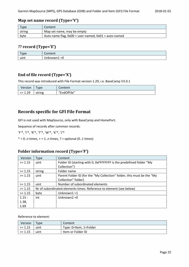
Map set name record (Type=’V’)Type Contentstring Map set name, may be emptybyte Auto name flag, 0x00 = user-named, 0x01 = auto-named
?? record (Type=’E’)Type Contentuint Unknown1 =0
End of file record (Type=’X’)This record was introduced with File Format version 1.29, i.e. BaseCamp V3.0.1
Version Type Content>= 1.29 string “EndOfFile”
Records specific for GFI File Format
GFI is not used with MapSource, only with BaseCamp and HomePort.
Sequence of records after common records:
‘F’*, ‘I’*, ‘R’*, ‘T’*, ‘W’*, ‘K’*, ‘J’*
* = 0..n times, + = 1..n times, ? = optional (0..1 times)
Folder information record (Type=’F’)Version Type Content>= 1.15 uint Folder ID (starting with 0, 0xFFFFFFFF is the predefined folder “My
Collection”)>= 1.15 string Folder name>= 1.15 uint Parent Folder ID (for the “My Collection” folder, this must be the “My
Collection” folder)>= 1.15 uint Number of subordinated elements>= 1.15 Nr of subordinated elements times: Reference to element (see below)>= 1.15 byte Unknown1 =11.15 -1.38,1.69
int Unknown2 =0
Reference to element:
Version Type Content>= 1.15 uint Type: 0=Item, 1=Folder>= 1.15 uint Item or Folder ID
Garmin MapSource (MPS), GPS Database (GDB) and Folder and Item (GFI) File Format 2018-01-01
Page 26
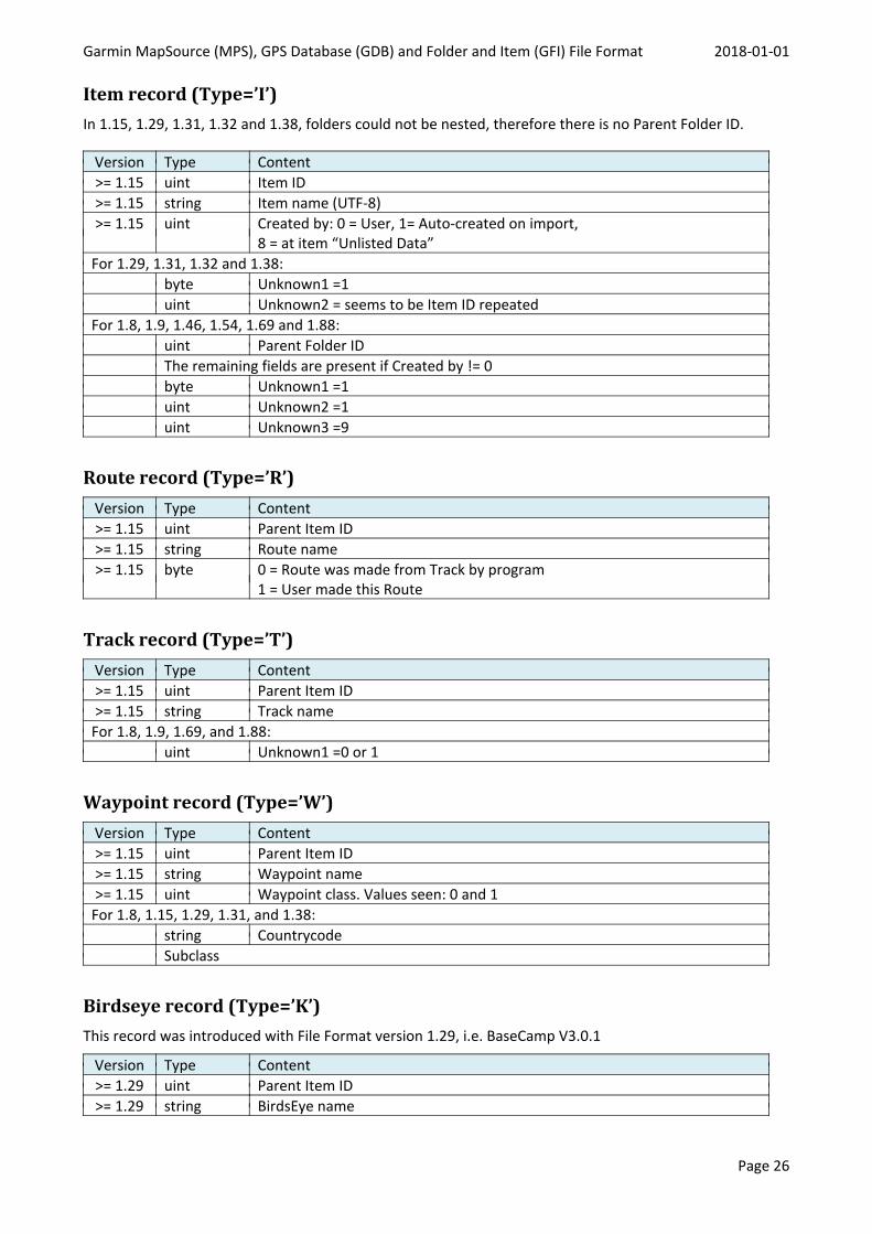
Item record (Type=’I’)In 1.15, 1.29, 1.31, 1.32 and 1.38, folders could not be nested, therefore there is no Parent Folder ID.
Version Type Content>= 1.15 uint Item ID>= 1.15 string Item name (UTF-8)>= 1.15 uint Created by: 0 = User, 1= Auto-created on import,
8 = at item “Unlisted Data”For 1.29, 1.31, 1.32 and 1.38:
byte Unknown1 =1uint Unknown2 = seems to be Item ID repeated
For 1.8, 1.9, 1.46, 1.54, 1.69 and 1.88:uint Parent Folder IDThe remaining fields are present if Created by != 0byte Unknown1 =1uint Unknown2 =1uint Unknown3 =9
Route record (Type=’R’)Version Type Content>= 1.15 uint Parent Item ID>= 1.15 string Route name>= 1.15 byte 0 = Route was made from Track by program
1 = User made this Route
Track record (Type=’T’)Version Type Content>= 1.15 uint Parent Item ID>= 1.15 string Track name
For 1.8, 1.9, 1.69, and 1.88:uint Unknown1 =0 or 1
Waypoint record (Type=’W’)Version Type Content>= 1.15 uint Parent Item ID>= 1.15 string Waypoint name>= 1.15 uint Waypoint class. Values seen: 0 and 1
For 1.8, 1.15, 1.29, 1.31, and 1.38:string CountrycodeSubclass
Birdseye record (Type=’K’)This record was introduced with File Format version 1.29, i.e. BaseCamp V3.0.1
Version Type Content>= 1.29 uint Parent Item ID>= 1.29 string BirdsEye name

Garmin MapSource (MPS), GPS Database (GDB) and Folder and Item (GFI) File Format 2018-01-01
Page 27
Birdseye record (Type=’J’)This record was introduced with File Format version 1.31, i.e. BaseCamp V3.0.3
Version Type Content>= 1.31 uint Parent Item ID>= 1.31 string BirdsEye name
Garmin MapSource (MPS), GPS Database (GDB) and Folder and Item (GFI) File Format 2018-01-01
Page 28
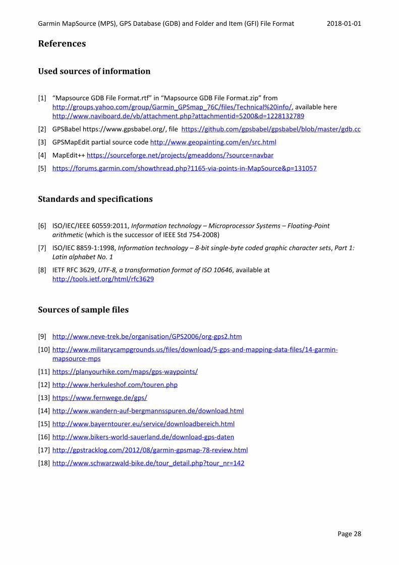
References
Used sources of information
[1] “Mapsource GDB File Format.rtf” in “Mapsource GDB File Format.zip” fromhttp://groups.yahoo.com/group/Garmin_GPSmap_76C/files/Technical%20info/, available herehttp://www.naviboard.de/vb/attachment.php?attachmentid=5200&d=1228132789
[2] GPSBabel https://www.gpsbabel.org/, file https://github.com/gpsbabel/gpsbabel/blob/master/gdb.cc
[3] GPSMapEdit partial source code http://www.geopainting.com/en/src.html
[4] MapEdit++ https://sourceforge.net/projects/gmeaddons/?source=navbar
[5] https://forums.garmin.com/showthread.php?1165-via-points-in-MapSource&p=131057
Standards and specifications
[6] ISO/IEC/IEEE 60559:2011, Information technology – Microprocessor Systems – Floating-Pointarithmetic (which is the successor of IEEE Std 754-2008)
[7] ISO/IEC 8859-1:1998, Information technology – 8-bit single-byte coded graphic character sets, Part 1:Latin alphabet No. 1
[8] IETF RFC 3629, UTF-8, a transformation format of ISO 10646, available athttp://tools.ietf.org/html/rfc3629
Sources of sample files
[9] http://www.neve-trek.be/organisation/GPS2006/org-gps2.htm
[10] http://www.militarycampgrounds.us/files/download/5-gps-and-mapping-data-files/14-garmin-mapsource-mps
[11] https://planyourhike.com/maps/gps-waypoints/
[12] http://www.herkuleshof.com/touren.php
[13] https://www.fernwege.de/gps/
[14] http://www.wandern-auf-bergmannsspuren.de/download.html
[15] http://www.bayerntourer.eu/service/downloadbereich.html
[16] http://www.bikers-world-sauerland.de/download-gps-daten
[17] http://gpstracklog.com/2012/08/garmin-gpsmap-78-review.html
[18] http://www.schwarzwald-bike.de/tour_detail.php?tour_nr=142