Embed Size (px)
Citation preview

GeoarchaeoloGical research at st. catherines island 2011 79
chaPter 3
GeoarchaeoloGical research at st. catherines island: deFininG the
GeoloGical FoUndation
Gale A. Bishop, Brian K. Meyer, R. Kelly Vance, and Fredrick J. Rich
st. catherines island is located at the head of the Georgia Bight, midway in the string of 12 barrier islands forming the Golden isles of the Georgia coast (fig. 3.1; Foyle, Henry, and Al-exander, 2004). With no proximal source of flu-vial sediment, st. catherines island is dependent upon net longshore transport of sand from north to south along the Georgia coast (hails and hoyt, 1969; McClain, 1980; Clayton et al., 1992). Net southward longshore transport is indicated by the chenierlike savannah river delta with south-ward accretion (alexander and henry, 2007), the chenierlike altamaha delta with its southward accretion, and southward migration of islands along the Georgia coast, and the building of the cape at cape canaveral, Florida (davis, 1994). this net southward transport of sediment is inter-rupted by local effects of flood and ebb currents at Georgia’s sounds, each forming a horizontal sand circulation pattern (Oertel, 1972a, 1977; oertel and Foyle, 1993) exchanging sand with the shelf and islands themselves (Swift, 1968; Pilkey, et al., 1981). Interruption of this flow of sand by damming rivers to the north and dredg-ing the savannah ship channel across the savan-nah river delta (U.s. army corps of engineers, 1991, 1996), has conspired with rising sea level to make st. catherines one of Georgia’s most ero-sional barrier islands (Griffin and Henry, 1984). recent sea level trends are documented on the national oceanic and atmospheric administra-tion sea levels online site for Fort Pulaski and savannah (noaa, 2003), indicating that cur-rently sea level is rising at a rate of 3 mm/yr (± of 0.2 mm/yr; 1935–1999). At Fernandina Beach, Florida, the rate is 2 mm/yr (1897–1999).
Understanding Georgia’s sea level changes demands accommodation of known data that constrain models and resultant sedimentologi-cal effects on shoreline position and elevation (Leatherman, Zhang, and Douglas, 2000; Doug-las, Kearney, and Leatherman, 2001; Coe, 2003). the height of maximum sea level rise in Georgia is equivalent to the elevation of the highest coast-al deposits of the Wicomico shoreline, or ter-race. although the array of preserved Pleistocene shoreline deposits or terraces provides evidence of progressive lowering of sequential sea level highstands (Stapor and Mathews, 1983; Gayes et al., 1992), it says little about the sea level low-stands during glacial stages. Vertebrate fossils and archaeological artifacts from subtidal coastal environments (dePratter and howard. 1977, 1981) and from the continental shelf allow par-tial reconstruction of lowstands (Garrison, 2006). systematic survey and submarine excavation at Gray’s Reef National Marine Sanctuary, 32 km (20 mi) offshore Georgia, and nearby J-reef, in the Atlantic Ocean, have identified two localities containing vertebrate fossil remains and two arti-facts, an organic artifact (a bone antler tool) and a lithic (a projectile point typologically assigned to the early Middle Archaic period (Garrison, 2006). Postglacial sea level must have recovered the 17–20 m (56–66 ft) depths at these locations during the Archaic period, ~8000 yr b.p., and as much as 40,000 yr b.p. prior to that, the areas sur-rounding Gray’s reef and J-reef were part of an exposed coastal plain. relative sea level rose in the holocene (post-12,000 yr b.p.) continuing to rise from full post-Wisconsin lowstand of over 100 m (328 ft) below present sea level (Garri-

ANTHROPOLOGICAL PAPERS AMERICAN MUSEUM OF NATURAL HISTORY 80 no. 94
Fig. 3.1. development of successive shorelines on the Georgia coast: A, successive shorelines, headlands, and intervening marshes (formations); B, recent silver Bluff Pleistocene and holocene shorelines of Georgia forming modern Golden Isles; C, cross section of Pleistocene to holocene sediment veneer of the Georgia coastal plain (after hails and hoyt [1969] and hoyt and hails [1967]).
Blackbeard Island
SapeloIsland
LittleSt. Simons Island
St. SimonsIsland
JekyllIsland
S O U T HC A R O L I N A
WILMINGTON ISLANDSKIDAWAY ISLAND Tybee
IslandWassawIsland
OssabawIsland
ST. CATHERINESISLAND
G E O R G I A
G E O R G I A
A T L A N T I C O C E A N
Pleistocenebarrier island(Silver Blu�)
A T L A N T I CO C E A N
LEGENDHolocene barrier island
Cumberland Island
F L O R I D A
SCALE0 5
mi10
S O U T H C A R O L I N A
MIO
CENE Pamlico
Formation
Penholo
way Fm
.Pr
. Ann
e Fm
.
Wico
mico
Form
atio
n
Penh
olow
ay F
m.
Wic
omic
o Fm
.
A'
A
IndexCross-Section(Below 1C)
Talb
ot F
m.
Pr. A
nne
Fm.
Silv
er B
lu�
Fm.
Holoc
ene
Hol
ocen
e
G A
F L O R I D A
OKE
FEN
OKE
ESW
AM
P
0 10 20km
30
LEGEND
FossilCallianassaburrowsBarrierislandfaciesLagoonalmarshfacies
SCALE
SCALE
A B
CA A'
Alta
mah
aRi
ver
0 2 4 6 8 10
KM
LEGEND
Lagoonal marshfacies
Barrier islandfacies
Wic
omic
oFo
rmat
ionWEST EAST
sea level
PenholowayFormation Talbot
Fm.
Miocene
PamlicoFormation Pr
ince
ssA
nne
Fm.
SilverBlu�
Formation Hol
ocen
e
Pliocene Pleistocene-40 -40-80 -80
0 0
40 40
80 80
120 120
FT.MSLFT.MSL

GeoarchaeoloGical research at st. catherines island 2011 81
son, 2006). sea level had dropped prior to the Late Glacial Maximum ~21,000 yr b.p. (Marine Oxygen Isotope Stage-2 [MIS–2]). Differential elevations of ancient barrier island or shoreline complexes and structural evidence suggest that tectonic as well as eustatic controls have been in effect. superimposed upon these eustatic and tectonic effects are sedimentological pulses pro-duced by Pleistocene climate changes and evolv-ing physical conditions influenced by possible coastal plain stream capture of inlets and sounds along the Georgia coast (Chowns et al., 2008; chowns, chap. 9, this volume).
the profound effects of sea level change were emphasized in a figure of Pleistocene coastal Georgia by a geographer (LaForge, 1925) in a map graphically depicting the configuration of southeast Georgia during the Wisconsin high-stand. MacNeil (1950) described the shorelines/terraces from Georgia and Florida citing four marine terraces and shorelines between sea level and ~29–30 m (~100 ft) above sea level. he proposed that the higher okeefenokee and Wicomico shorelines could be correlated with the Yarmouth and Sangamon interglacial stages, re-spectively, the Pamlico shoreline correlated with a mid-Wisconsin ice recession, and the lowest, the silver Bluff shoreline with post-Wisconsin. Hoyt, Henry, and Weimer (1968); Hails and Hoyt (1969), and hoyt and hails (1967) described the formation of a veneer of Pleistocene sediments across the Georgia coastal plain (fig. 3.1, lower) as sea level fluctuated throughout the Pleistocene and apparently dropped with each subsequent in-terglacial sea level rise; these sediments built a sequence of barrier island complexes (fig. 3.1A, B) that got progressively younger, and lower in elevation, toward the present coastline.
the problem of sea level rise and fall illus-trates the complexity of geology as a unique criti-cal thinking paradigm applying logical reasoning first to the stratigraphic problem, then to the in-terpretation of the stratigraphy (Frodeman, 1995). hoyt, Weimer, and henry (1964) described the stratigraphy of the mid to late sangamon and Pamlico, Princess anne, and silver Bluff paleo-shorelines on the Georgia coast. the silver Bluff deposits form the core of many modern barriers including ossabaw, st. catherines, sapelo, st. simons, Jekyll, and cumberland islands with as-sociated silver Bluff marsh lithosomes currently submerged by the holocene transgression. along the Georgia coast these sea level fluctuations re-
sulted in deposition and erosion of a seaward-dip-ping veneer of Pleistocene sediment arranged in a series of barrier island sequences that are younger to the east. the deposition of coastal terraces or barrier island ridges (Wicomico, ~29–30 m [~98 ft]; Penholloway, ~23 m [~75 ft]; Talbot, ~12–14 m [~39–46 ft]; Pamlico, ~8 m [~26 ft]; Princess Anne, ~4.5 m [~14 ft]; Silver Bluff, ~1.5 m [~5 ft]; and Holocene) in Georgia form a continuous veneer of Pleistocene sediment of varying thick-ness and lithology (Huddleston, 1988). Shoreline elevations were based on the elevations of fossil burrows of Callichirus major (Say, 1817–1818; Rodrigues, 1983).
hoyt and hails (1967), hails and hoyt (1969), Pickering and Murray (1976), Linsley (1993), Bishop et al. (2007), linsley, Bishop, and rol-lins (2008), Reitz (2008), Thomas (2008), and others, have suggested that the most recent set of Georgia barrier islands consist of older sedi-ment deposited about 35,000 to 40,000 years ago with younger sediment to the east accumulat-ing against the island about 4000 to 5000 years ago (fig. 3.1, upper right). The Pleistocene parts of the islands formed when the sea level was ~ 2.0 m (6.5 ft) above the present level, before the formation of the last great continental ice sheet of the Pleistocene epoch, the Wisconsin Glacial Stage, that lowered sea level 80 m (~260 ft), plac-ing the shoreline 128 km (~80 mi) offshore near the present edge of the continental shelf.
Gray’s Reef (Henry and Hoyt, 1968; Hunt, 1974) is an exposed dolomitized micritic lime-stone hardground interpreted by Woolsey (1977) to be stratigraphically and lithologically equiva-lent to the raysor shelly sand. it had been origi-nally referred to as the sapelo facies of the du-plin formation. subsequent geological studies include Continental Shelf Associates, Inc., 1979; Henry and Giles, 1980; Henry, 1983; Van Dolah, Calder, and Knott, 1984; Van Dolah, Wendt, and Nicholson, 1987; Henry, Dean, and Olsen, 1987. Huddleston (1988) later revised the lithostratig-raphy of the Georgia coastal sediments.
according to this literature, the present glob-al rise in sea level began approximately 20,000 years ago, moving across the exposed continen-tal shelves about 1 m/100 yr until ~6000 years ago, at which time the rate of rise slowed to ap-proximately 0.3 m/century until today. Garrison (2006) documents the existence of Gray’s reef above sea level some 15,000 years ago when Georgia’s shoreline was more than 60 mi east

ANTHROPOLOGICAL PAPERS AMERICAN MUSEUM OF NATURAL HISTORY 82 no. 94
of its present position. off the coast, divers have discovered fossils of now-extinct land-dwelling animals, such as ground sloths, mastodons, and early camels, horses, and bison. Gray’s reef inundation began ~7000 yr b.p. (Henry, 2005). thus, after several cycles of submergence and emergence, with the latest period of exposure lasting 40,000 years, the substrate was once again covered by the ocean and once again be-came a live bottom.
swift et al. (1972) recognized that inlet, ebb-tidal delta, and estuarine deposits from low-stands of late Pleistocene and holocene sea level are principal sources of sediments for building current beaches. chester dePratter and James Howard (1977, 1981) studied the “History of shoreline changes determined by archaeological dating: Georgia coast,” documenting the exis-tence of intertidal archaeological sites (see also caldwell, 1971).
Winker and Howard (1977) described diffi-culties in correlation of Pleistocene paleoshore-lines of the lower coastal plain between Florida and Virginia and presented a new terminology (Chatham, Effingham, and Trail Ridge sequenc-es) for paleoshorelines. Well-developed trellis-style drainage networks were described land-ward of the talbot paleoshoreline and dendritic drainage patterns prevail at lower coastal plain elevations associated with the modern through Pamlico-talbot paleoshorelines. they suggested that up to 50 m of downwarping and upwarping along the orangeburg trail ridge scarp between north Florida and southern north carolina was possible. Pilkey et al. (1981) described common lagoonal deposits on the shelf and proposed that southeastern barrier islands are not just mid- to late-holocene features but migrated across most of the shelf during the current transgression. Ma-son (1993) determined the usefulness of beach ridge archaeology for identifying rates and tim-ings of coastal change, climate change, and sea level variation for progradational coasts based on the fact that human settlement favors open coast-lines that correlate with changes in the shoreline. Gayes et al. (1992) identified a mid-Holocene (4.2 ka) highstand of relative sea level at Murrells In-let, south carolina followed by a fall in sea level of 2 m until 3.6 ka and then a constant sea level rise of 10 cm/century to the present. McBride and Byrnes (1993) compared Louisiana, Mississippi, and Georgia barrier coastlines. shoreline change rates on the Georgia coast have averaged about
1 m/yr over the past century, leading to stable central shorelines with most fluctuations occur-ring adjacent to tidal inlets. in Georgia, barrier islands commonly exhibit lateral accretion, pro-gradation, and dynamic equilibrium, which are the primary responses of barrier coastlines.
riggs and cleary (1993) recognized that many East Coast barrier islands are “perched” barriers whose forms are strongly determined by ante-cedent topography and the types of antecedent sediments available to wave/current erosion on the shoreface and foreshore. the structural and stratigraphic characteristics of a barrier island complex influence barrier island morphology, inlet development, and beach dynamics (hoyt, 1967). Scott, Gayes, and Collins (1995) and Scott and Collins (1995) recognized a rapid increase in sea level rise to a point about 1.5 m above cur-rent sea level in south carolina. Wanless (2002) described holocene coastal change on the mud-dominated microtidal mangrove coast of west Florida that is migrating landward at rates of as much as 4 m/yr with a 3 mm/yr relative sea level rise rate (causing coastal submergence).
langley et al. (2003) described the quan-tification of shoreline change on the Georgia coast on Wassaw and st. catherines islands us-ing shoreline data from 1856 and 1924 and re-viewed the history of shoreline mapping on the Georgia coast. the authors state that Wassaw and st. catherines islands exhibit shoreline-change patterns proposed by hayes (1994) to be typical of Georgia Bight barriers in that erosion occurs on the updrift ends and accretion occurs on the downdrift ends. While this is a good general-ization, it is an oversimplification, being true at limited temporal and spatial scales (Foyle, hen-ry, and alexander, 2004). langley et al. (2003) show that st. catherines island does not exhibit this typical behavior. the data appear to reveal the downdrift migration of an accretionary bulge that is probably fed by onshore-migrating sand bars from the updrift ebb-tidal delta. however, the time frame within which this process typi-cally operates on the Georgia Bight is not well known. st. catherines island has become shorter (1852/1871–1911/1924) and shows shoreline re-treat along its entire length with some stability along its central portion (Goodfriend and rollins, 1998). Griffin and Henry (1984) attributed this to the island’s distal location downdrift of sig-nificant sediment input from the Savannah River. shoreline retreat rates on st. catherines island

GeoarchaeoloGical research at st. catherines island 2011 83
vary from –1.6 to –9.2 m/yr (see Bishop and Meyer, chap. 14: fig. 14.11; and Potter, chap. 7).
Fred Pirkle led the study of the geological his-tory of the Georgia coast to better define and lo-cate deposits of heavy minerals (smith, Pickering, and Landrum, 1968; Pirkle et al., 1991; Pirkle, Pirkle, and Pirkle, 2007) and define their mode of accumulation as placers left behind on the backbeach as swash winnows out the less dense quartz fraction. Bishop studied the distribution of heavy minerals on st. catherines island (1990), finding them concentrated along the backbeach in a series of nodes, in the backbeach dune fields, and onto the midbeach. Vance and Pirkle (2007) summarized the distribution and provenance of heavy minerals on the Georgia coast.
a burst of geological research in the late 1990s resulted from the Georgia state University master’s thesis work of robert Booth, under the supervision of Fred Rich. Booth et al. (1998), Booth, rich, and Bishop (1999), and Booth et al. (1999) described aspects of the stratigraphy of st. catherines island. Booth and rich (1999) de-scribed a dense peat from the cracker tom bridge core at a depth of 5.02–5.12 m (total depth) that consisted of 85% monolete pteridophyte spores and was dated (AMS) at 47,620 ± 2500 yr b.p.
Bartholomew et al. (2007) have studied joint orientations on the Georgia coast and rich and Bishop (personal commun.) examined possible joints at Yellow Banks Bluff in September 2006.
During the 1980s and 1990s, the University of Pittsburgh group also conducted extensive geo-logical research (largely paleoecological and sedi-mentological) on st. catherines island, including the work done by K. Beratan, R.M. Busch, J.D. donahue, n.J. delillo, J.F. Fierstien, s.K. Ken-nedy, D.M. Linsley, P. Mannion-Rowe, R. Pinko-ski, J.e. Pottinger, J.c. rollins, h.B. rollins, B.l. sherrod, c. Venn, F. Vento, and r.r. West.
RECENT SEA LEVEL RISEat st. catherines island
sea level rise is occurring at the same time that we have dammed streams, dredged the sa-vannah ship channel, and interrupted the south-ward flow of sand along the coast of Georgia. Consequently, there is a deficiency in sand sup-ply, placing many islands under increasingly erosional conditions, especially st. catherines Island, which has no significant local influx of
fluvial sand from the short mainland creeks en-tering st. catherines and sapelo sounds. these conditions have made st. catherines island one of Georgia’s most dynamic and erosional barrier islands (see fig. 3.3). In this context, St. Cath-erines is a sentinel island for the other barrier islands of the Georgia coast—predicting increas-ingly erosional conditions for all the Golden isles as these conditions continue and strengthen.
erosion of the east and north shores was doc-umented in the 1970s by McClain (1980). Morris and rollins (1977) mapped biological associa-tions within relict marsh mud exposed as erosion exposed ancient marshes along the beaches of St. Catherines Island. Monitoring erosion and accretion of the shoreline at st. catherines was expanded during the past 20 years by students in the University of the south’s island ecology Program to include more than 25 stations with more or less continuous measurement of shore-line change. Bishop initiated documentation of beach habitat deterioration through an annual Rapid Habitat Assessment (Bishop and Marsh, 1999b) survey to characterize those deteriorating conditions through a semiquantitative of sea tur-tle habitat during the mid 1990s (see Bishop and Meyer, chap. 14: table 14.2), a technique adapted for application to all Georgia barrier islands in a continuing longitudinal study by the coastal re-sources division of Georgia department of natu-ral Resources (Dodd and MacKinnon, 2006). In 2006, investigators working on st. catherines island were invited to report surf conditions, rip currents, and erosional beach conditions during storms (davis and dolan, 1993) to noaa coast-al services center, in charleston, s.c.
SEA LEVEL HISTORYoF st. catherines island
st. catherines island is comprised of older silver Bluff Pleistocene sediment forming the western high-standing core of the island (the is-land core) surrounded by younger, low-standing Holocene accretionary terrains (see fig. 3.2). these major sedimentary packages are separated by a series of scarps, bluffs, or other dichotomous boundaries (fig. 3.2). These ancient and modern erosional boundaries and sedimentary packages provide evidence of episodic erosion and de-position (see chap. 14: fig. 14.11) as the island changed through time in response to fluctuating sea level, changes in sedimentation rates, and
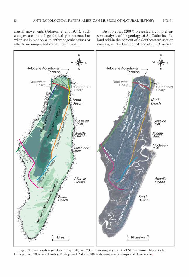
ANTHROPOLOGICAL PAPERS AMERICAN MUSEUM OF NATURAL HISTORY 84 no. 94
crustal movements (Johnson et al., 1974). such changes are normal geological phenomena, but when set in motion with anthropogenic causes or effects are unique and sometimes dramatic.
Bishop et al. (2007) presented a comprehen-sive analysis of the geology of st. catherines is-land within the context of a southeastern section meeting of the Geological society of american
Fig. 3.2. Geomorphology sketch map (left) and 2006 color imagery (right) of st. catherines island (after Bishop et al., 2007, and Linsley, Bishop, and Rollins, 2008) showing major scarps and depressions.
Back
Cre
ek
Wal
burg
Sca
rp
Wal
burg
Sca
rp
King
New
Gro
und
Scar
p
King
New
Gro
und
Scar
p
NorthwestScarp
NorthwestScarpSt.
CatherinesScarp
St. CatherinesScarp
cent
ral d
epre
ssio
n
cent
ral d
epre
ssio
n
EngineersScarp
EngineersScarp
Wamassee
Scarp
Scar
p
Scar
p
Back
Cre
ek
Plei
stoc
ene
(old
er)
Plei
stoc
ene
(old
er)
Plei
stoc
ene
(you
nger
)
Plei
stoc
ene
(you
nger
)
Holoc
ene A
ccre
tiona
l Ter
rains
Holoc
ene A
ccre
tiona
l Ter
rains
Holocene Accretional Terrains
Holocene Accretional Terrains
North Beach
North Beach
MiddleBeach
MiddleBeach
Seaside Inlet
Seaside Inlet
McQueen Inlet
McQueen Inlet
AtlanticOcean
AtlanticOcean
SouthBeach
SouthBeach
Miles0 1 Kilometers0 2
N
EW
S
N
EW
S
Wamassee
Scarp

GeoarchaeoloGical research at st. catherines island 2011 85
(seGsa) technical session and Fieldtrip. the basic geomorphology of st. catherines was pre-sented within hypotheses of the formation of the island’s foundation and geological history. this work brought together aspects of geology, ecol-ogy, archaeology, and history.
Reitz et al. (2008), Linsley, Bishop, and Rol-lins (2008), and Thomas (2008) examined as-pects of the natural history and evolution of st. catherines island, which, along with Bishop’s fieldnotes, forms much of the observational data reported herein. the publication of Native Ameri-can Landscapes of St. Catherines Island (thom-as, 2008) provided the impetus for development of the caldwell iV conference stressing the geo-archaeology of st. catherines island, which we hope will expand our knowledge by inclusion of new ideas from the usual suspects and new input and testing by new research colleagues.
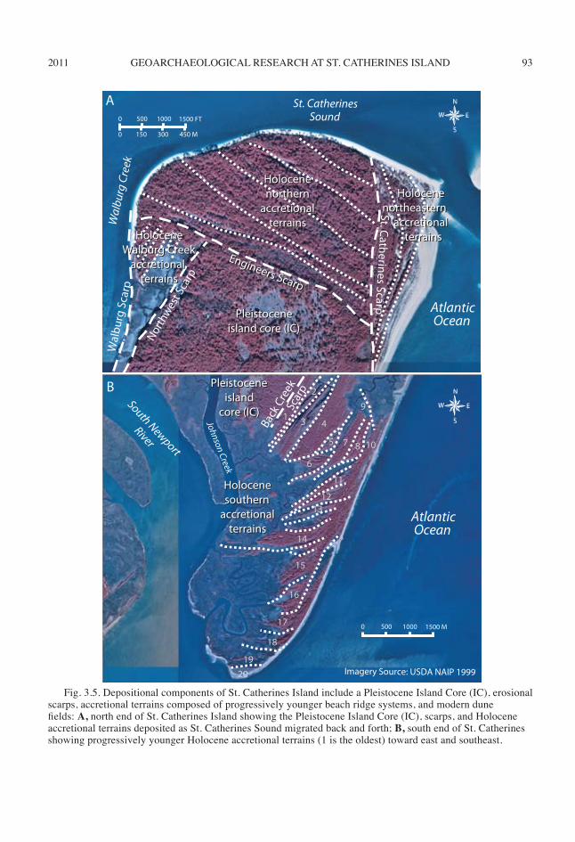
St. Catherines Island (see fig. 3.1), consists of two distinctive entities defined by variations in topographic relief, or “texture” (fig. 3.2), a high-standing, relatively featureless central area to the west and northwest and a low-standing, highly textured fringing area to the east and southeast (Bishop, 1990; Bishop et al. 2007: fig. 3.40; Reitz et al., 2008). The high-standing area, the island core, is characterized by an elevation of approxi-mately 5 m, a mature mixed, deciduous-pine for-est, former agricultural fields in various degrees of succession, and a robust archaeological re-cord. the high-standing portion of the island is mapped as Pleistocene silver Bluff facies on the geologic map of Georgia and the low-standing area is mapped as Holocene (Pickering and Mur-ray, 1976). the low-standing accretionary terrain is characterized by an elevation of ~1 m, alternat-ing beach-dune ridge systems and swales, and in-tervening freshwater ponds or tidal creek-marsh meadows. the ridges are often forested by vari-ous trees, which are rather distinctly distributed along specific ridge systems (Coile and Jones, 1988) and are dominated by cabbage palm, hick-ory, pine, or live oak.
the central, high-standing island core is flanked by low-standing Holocene sediments at the north and south ends of the island and along the oceanic eastern margin. the eastern margin is characterized by broad marsh meadows de-veloped behind long sand spits at seaside inlet, Middle Beach, and McQueen Inlet. The southeast end of st. catherines island consists of a sequence of approximately 22 beach ridge systems, which
generally become progressively younger seaward and southeasterly and can be seen on aerial pho-tographs and orthophotomaps to possess discrete, often dichotomous boundaries (figs. 3.2 and 3.5 and Bishop and Meyer, chap. 14: fig. 14.6). These packages of sediment represent rapid periods of accretionary activity during the holocene punctu-ated by periods of erosional activity giving rise to “sedimentary accretionary terrains,” which may be chronologically sequenced based on their po-sition by using crosscutting relationships at their boundaries, and possibly by archaeological dating (Thomas, 2008). The pattern of these accretion-ary terrains records the depositional history of the holocene part of the barrier island in their pres-ence, sequence, and distribution. thus the holo-cene sedimentary accretional terrains provide a powerful tool to decipher the holocene history of the entire island, as well as the record of sea level fluctuation, rate of sediment supply, and shoreline fluctuation in the recent past. This, in turn, allows sedimentological prediction of the near future as sea level rises due to global warming.
Boundariesin general, the boundary between the island
core facies and the holocene sedimentary accre-tionary terrains is demonstrably erosional (see fig. 3.2). At both ends of the island the low-stand-ing linear holocene beach ridge systems stand in marked contrast to the higher, less-textured Pleistocene core (figs. 3.3 and 3.4). These ero-sional boundaries represent surfaces formed by episodes of erosion due either to eustatic sea lev-el changes, pulses of erosion and sedimentation, or lateral migration of subtidal erosional environ-ments such as channels of sounds and meandering tidal rivers. Each erosional event is identifiable in map view by dichotomous beach ridge orienta-tions and often by small differences in elevation of adjacent sequences of sediment, and differenc-es in vegetation or archaeological age (fig. 3.3). each erosional event may also be identifiable in stratigraphic sections as a minor unconformable sequence or diastem that dips either seaward or into adjacent areas that had lowered base levels (fig. 3.4). When such erosional surfaces are de-stroyed by subsequent erosional events, their for-mer existence and location become conjectural. Each identifiable boundary has been given a local name to expedite communication in this chapter (Bishop et al., 2007).
the boundary between the island core facies
ANTHROPOLOGICAL PAPERS AMERICAN MUSEUM OF NATURAL HISTORY 86 no. 94
and the holocene sedimentary accretionary ter-rains on the east side of the island consists of three major arcuate erosional scarp systems (fig. 3.2). the oldest scarp, the King new Ground Scarp, runs from the south end of Yellow Banks Bluff, the Silver Bluff (Hails and Hoyt, 1968) erosional bluff on north Beach, to cracker tom creek behind south Beach. Back creek scarp can be traced from cracker tom causeway to the south end of the island core. st. catherines scarp is herein restricted to the northernmost part of the island, essentially fronting Yellow Banks Bluff. King new Ground scarp is arcuate and brings the silver Bluff core facies into contact with marsh meadows, which lie topographical-ly 3–5 m (10–15 ft) lower than the Silver Bluff core. this emarginate boundary, developed on the King new Ground scarp as former meanders of the tidal creeks lying within the seaside marsh meadows, cuts into the adjacent island core (fig. 3.4). From cracker tom causeway to the south is a second eastward-dipping erosional scarp, Back creek scarp, whose presence and age relative to the King new Ground scarp are indicated by the presence of a straight scarp forming the east edge of the ancient island flanked to the east by depo-sitional ridges and swales.
the sedimentary accretionary terrains at both ends of the island that are oriented perpendicu-lar to the northeast-southwest trending beaches represent former channel margin sediments of st. catherines sound and sapelo sound. Because these areas were formed by lateral migration of sound systems relatively independent of eustatic change, the lateral erosional and depositional events at opposite ends of the island are thought to have been relatively independent of one an-other. eustatic events, however, should be cor-relatable in a large sense as they are drivers of gradients and channel morphology.
at the north end of the island we now recognize two additional scarps, northwest scarp and engi-neers Scarp (fig. 3.2). Northwest Scarp is a short scarp that strikes northeast from Walburg scarp forming the boundary between the island core and Northwest Marsh. Engineers Scarp is the erosional boundary between the island core and the northern holocene accretionary terrains. engineers scarp is truncated to the east by st. catherines scarp, a former sound margin of st. catherines sound, and truncated to the west by Walburg scarp.
the number, extent, and variable orientation of holocene accretionary terrains indicates that
several times during the holocene, the sound channels have migrated dramatically and some-times rapidly, significantly eroding older por-tions of the holocene part of the island that sub-sequently accreted as the sound channel migrated back in the opposite direction. this hypothesis would suggest that the sounds and Pleistocene cores of barrier islands on the Georgia coast are relatively stable features, but that the uncon-strained mouths of sounds act somewhat like loose fire hoses, whipping rapidly back and forth along the coastline, giving rise to the erosional boundaries and sedimentary packages of the ac-cretional terrains. if this is the case, the relative ages of surface exposures and stratigraphic facies tracts ought to confirm the hypothesis. Chowns et al. (2008) have postulated the rapid relocation of fluvial-dominated sounds as a mechanism for forming the northeastern islands in island dou-blets (see chap. 9).
core samples obtained by vibracoring during the fall of 1989 and the spring of 1990 demon-strated the stark contrast between the island core facies and the holocene sedimentary accretion-ary terrains. the island core facies exposed at Picnic Bluff and in a core recovered at Mission santa catalina de Guale both consist of rela-tively homogeneous sands that has been deeply leached and presumably homogenized by in-tensive bioturbation by root growth and other organic processes. the core recovered from the Mission Santa Catalina de Guale site penetrated clean, light tan, quartz sand at approximately 60 cm and terminated at 3.23 m in an organic-rich, chocolate brown, humic sand. the only evidence of sedimentary structures was a few sparse root casts and mottling at 2.10 m. Four cores were taken from the holocene sedimentary accre-tionary terrains on cracker tom causeway, an intermediate-age, east-west oriented terrain (see chap. 10: fig. 10.4), and from the northern end of Beach Pond, immediately behind the pres-ent beach ridge system. all four cores show re-markable vertical sequences of sediment derived from deposition in coastal environments similar to those nearby. three of the four terminate in deeply colored sediments at approximately 5.0 m below current high marsh level. one of these, the Cracker Tom Bridge core (GAB 9005051), termi-nates in the upper 14 cm of an unknown thickness of deep blackish-brown, dense peat that has been dated by 14C methods (figs. 10.2D and 10.7). The surface, represented by deeply colored terrestrial

GeoarchaeoloGical research at st. catherines island 2011 87
sediments at approximately 5.0 m in cores taken along Cracker Tom Causeway (see chap. 10: figs. 10.6 and 10.8), is considered to be the contact between the holocene and the top of the Pleis-tocene as well as the disconformity representing Back creek scarp in the subsurface.
relict marsh exposed near the southern tip of st. catherines island constrains the age of south-ward accretion of the holocene terrains by repre-senting the youngest preserved, datable lithologic sequence of marsh deposited before the current erosional cycle began. this marsh mud contains a detrital peat layer near its surface, overlain by rooted marsh muds with in situ articulated and dis-articulated shells of the marsh-dwelling bivalves Mercenaria, Geukensia, and Crassostrea as well as the marsh-dwelling gastropod Littoraria. the bedded peat, a piece of wood included in the mud beneath the peat, and shells of Crassostrea, Geu-kensia, and Mercenaria from above the peat were sampled and are being dated by 14c methods.
the presence of extensive seaside marsh meadows along the atlantic margin of st. cathe-rines Island, the presence of a significant erosional bluff on north Beach, the presence of thick, rel-ict marsh muds exposed along stretches of north Beach, Middle Beach, and South Beach, and the abundance of significant heavy mineral placers all firmly substantiate that not only has there been significant erosion along the Atlantic margin of the island, but that there was a formerly signifi-cant barrier island to the east of st. catherines Island. Seaside and McQueen marsh meadows developed as interisland marshes before they en-tered their current erosional phase. the geomor-phology of the proposed st. catherines island couplet would be analogous to other Georgia sea Island couplets, such as St. Simons–Sea Island or Sapelo–Blackbeard Island (fig. 3.6). This com-parison leads to the conclusion that a seaward barrier island, named Guale Island (Bishop, 1990; Bishop et al., 2007; Linsley, Bishop, and Rollins, 2008; and Reitz et al., 2008), once existed off the northeast edge of modern st. catherines island. Guale island suffered total destruction from ero-sion by southerly longshore currents entering the Georgia Bight from the northeast and is perhaps linked to stream piracy of the canoochee river by the Ogeechee River (Chowns et al., 2008) and a subsequent decrease in sediment delivery to st. catherines sound and to st. catherines island.
although still largely speculative, the re-cent history of st. catherines island built on the
Guale island hypothesis (Bishop, 1990) allows a framework for evolution of st. catherines island to be set and tested, although absolute timing of some events forming the island core remains un-known (fig. 3.3).
Constraints on Historical Speculationthe reconstruction of the geological history
of st. catherines island remains partly specula-tive at this time because subsurface data are only now being systematically gathered and analyzed in the context of surface geology, geomorphol-ogy, and archaeology. the major constraints on such speculation include the lithologies, orienta-tion, and surficial textures of different parts of the island; presence of major erosional boundaries as indicated by differing orientations of surficial tex-tures and relative ages of sedimentary accretional terrains; relative dating derived from crosscutting relationships; archaeological dating; and absolute dates provided by 14c dating. these data, when integrated with analogous findings from adjacent island systems, provide a technique to decipher the major historical events that have shaped st. catherines island. among these events, the pres-ence, position, and relative age of major erosional boundaries seem most liable to provide sound se-quencing of past events. such boundaries clearly separate older sedimentary accretional terrains from younger ones. such erosional boundaries are not only surficial, but also form disconform-able relationships in stratigraphic sections.
in constructing our more recent geological history of st. catherines island, we summarize evidence as we knew it in 2007 and 2008. From that base, we have constructed an interpretation of the geological history of the island constrained by parameters cited above (fig. 3.3). The interpre-tation of the island’s geological history continues to evolve as new data become available.
The evidence, as known in 2008, consisted of the following observations:
1. the oldest part of the island, the Pleisto-cene silver Bluff core, consists of homogeneous sands, nearly lacking surficial textures, and deeply leached with concentrations of organic-rich humate at depth with a central depression and a lineament that may be a boundary be-tween older and younger depositional units in the island core.
2. Major erosional boundaries are identifiable at the edges of the core, including Back creek scarp, st. catherines scarp, Walburg scarp, Wa-

ANTHROPOLOGICAL PAPERS AMERICAN MUSEUM OF NATURAL HISTORY 88 no. 94
Fig. 3.3. a geomorphological depiction illustrating one possible scenario for the development and evolution of st. catherines island (Bishop et al., 2007): A, st. catherines shoal at time of deposition of Princess Anne paleoshore; B, formation of initial Silver Bluff Pleistocene core of island; C, erosion of older Pleistocene core results in long, narrow island and adds sediment to the south; D, welding of younger Pleistocene core onto entire length of island; E, meander of Zapala sound erodes older Pleistocene coupled with development of complex St. Catherines/Guale barrier island doublet; F, Wisconsin low-stand shoreline recedes 32 km east near Gray’s reef, island is part of low-relief mainland.
0 3 KM3 KM0
5 KM0
0 3 KM
0 5 KM 0 3 KM
Prin
cess
Ann
e Sh
orel
ine
King NewGround Scarp
wel
ding
of y
oung
erPl
eist
ocen
e
Sapelo Shoal
modernSt. CatherinesIsland
St. CatherinesShoal
Island Core–Younger
Pleistocene
Back CreekScarp
GualeIsland
Zapala
Sound Erosion
Old Sapelo River
Old Medway River
St. C
athe
rines
Rid
geSt. Catherin
es
Creek
to shorelineapprox. 32 km
Sapelo Shoal
eros
ion
of sh
oref
ront
tran
spor
t to
SW
A B C
D E F
modernSt. CatherinesIsland
modernSt. CatherinesIsland
modernSt. CatherinesIsland
modernSt. CatherinesIsland
Island Core–Younger
Pleistocene
Island Core–OlderPleistocene
Island Core–Older
PleistoceneIsland Core–Older Pleistocene
Island Core–OlderPleistocene

GeoarchaeoloGical research at st. catherines island 2011 89
Fig. 3.3 (continued). G, sea level rises, Guale island erodes and sand is transferred southward forming the older accretional terrains; H, destruction of Guale with transfer of sand forms barriers protecting seaside and McQueen marshes as North Beach is exposed to the ocean and erosion forms a marine terrace as Zapala Sound migrates north, truncating older accretional terrains and forming terrain #6 of fig. 3.5B; I, sand transfer south from Guale continues building southern accretional terrains, meandering tidal creeks erode emarginations into King New Ground Scarp, and blowing sand buries the terrace; J, present configuration of the island as Native Americans found it; K, present-day island with major scarps overlain, and L, future configuration of the island using current accretional/erosional areas.
GualeIsl.
eros
ion
of G
uale
trans
port
to S
W
3 KM0
LEGEND
3 KM0
3 KM0
GualeIsl.
terrestrialdeposit
EngineersScarp
3 KM0
ZapalaSound
GualeIsl.
3 KM0
3 KM0
J K
G I
modernSt. CatherinesIsland
Island Core–Older
Pleistocene
Island Core–Younger
Pleistocene
modernSt. CatherinesIsland
modernSt. CatherinesIsland
Island Core–Older
Pleistocene
Island Core–Older
Pleistocene
Island Core–Older
Pleistocene
Island Core–Older
Pleistocene
Island Core–Younger
Pleistocene
Island Core–Younger
Pleistocene
Island Core–Younger
Pleistocene
Island Core–Younger
Pleistocene
older accretionalterrains
northernaccretional
terrains
marineterrace
northeast–continuedaccretion
east–continuedretreat
south–continuederosion
H
L
Northwest ScarpSt. Caths. ScarpWalburg ScarpWamassee ScarpEngineers ScarpKing New Ground ScarpBack Creek Scarp

ANTHROPOLOGICAL PAPERS AMERICAN MUSEUM OF NATURAL HISTORY 90 no. 94
massee scarp, and the modern shoreline, which is undergoing erosion over most of its length.
3. the King new Ground scarp, forming the north-south boundary between the silver Bluff Core and the Holocene Seaside Marsh Meadow from Picnic Bluff at least to cracker tom cause-way has been partially obscured by ancient me-ander scars of tidal creeks where they impinged on the island core.
4. the newer holocene part of the island consists of highly variable, textured sequences of sediment of varying type, often exhibiting di-chotomous boundaries and orientations of beach ridge systems, which can be ordered in relative depositional sequence.
5. Relict marsh is currently exposed along all beaches, especially the south end of north Beach, nearly all of Middle Beach, and the north and south ends of South Beach (Morris and Rol-lins, 1977).
6. The Seaside Marsh muds exposed behind Black hammock spit on the south end of north Beach are at least 9.14 m (30 ft) thick in places.
7. evidence of ancient tidal creeks is pre-served as two oxbows at the north end of Picnic Bluff and as sand-filled meanders near the south end of north Beach.
8. The concentration of heavy mineral placers on the beaches is anomalously high (Jack reyn-olds, personal commun.), indicating winnowing of a considerable amount of sediment from erod-ing shorelines.
9. Vibracores through the holocene accretion-ary terrains penetrate multiple progradational se-quences separated by erosional surfaces.
10. Vibracores in the sedimentary accretional terrains on cracker tom causeway and on the west side of the island at st. catherines shell ring penetrate deeply colored peats and marsh deposits near the holocene-Pleistocene contact at approximately 5 m.
11. 14c dates, where possible, allow surfaces and lithosomes to be dated.
12. archaeological data could indicate when a surface was available to human utilization, a minimum age of formation.
sea tUrtles, sea leVels,AND GEOLOGY
observations that are anomalous or repre-sent a misfit to our worldview form the basis of the search for new knowledge (Brannen and
Bishop, 1993; Darrell, Brannen, and Bishop, 1993; Bishop and Marsh, 1999a; Bishop et al., in press). in the normal operations of the st. catherines island sea turtle Program, op-portunities have arisen to make numerous ob-servations and deductions, and to participate in application of new technologies to investigate the formation of the island. some observations were directly associated with the st. catherines island sea turtle Program and others were made as asides to this program. a review of the timing of these observations (Bishop: personal records, field notebooks) was made to attempt to define the flow of the observations, deductions, and ap-plications … and what each had to do with our evolving concept of st. catherines island.
during the initial phases of research on st. Catherines by Bishop (1986–1990) and during initialization of the st. catherines island sea tur-tle Program (1990–present), it became obvious that unknown circumstances were negatively af-fecting hatching success of in situ sea turtle eggs in nests along part of north Beach between sand Pit Road entrance and Yellow Banks Bluff. It was postulated that ground water conditions were re-sponsible for the poor hatching conditions, so four standpipes were jet-drilled into the accretional terrace from the backbeach toward the southwest into an ancient oxbow. two oxbows were pres-ent at that time, one between Picnic Bluff and the major part of Yellow Banks Bluff and one to the north, just south of sand Pit road (into which the southwestern-most standpipe was inserted). during the drilling process, and as indicated in a vibracore taken by Bran Potter in his island ecol-ogy class (Bishop et al., chap 10: fig. 10.3), a peat and underlying marsh mud were encountered at a depth of about 2 m on the front side of the island. another core, further south near the south end of Yellow Banks Bluff, replicated this anomalous condition in an area in which we expected to en-counter mostly sandy sediment.
On August 26, 1996, colleague Nancy Marsh reported the presence of exposed ghost shrimp burrows eroding along the front of north Beach. Upon checking, the knobby, mud-lined burrows proved indeed to be the lower part of the bur-rows, a horizontal burrow maze that forms at 2–5 m below the midbeach level. this elevation of the lower part of burrows indicated that, at the time the burrows were active, sea level was high-er than it is now by about 2–5 m or so. This de-duction, along with continuing erosion of Yellow

GeoarchaeoloGical research at st. catherines island 2011 91
Banks Bluff, led to a close examination of the bluff (often cited as the only exposed and erod-ing Pleistocene on the Georgia coast). on July 17, 2001, Bishop measured a detailed section at Yellow Banks Bluff and depicted small, unlined burrows throughout half of the section and a zone of truncated burrows in a horizontally laminated humate layer about 20 cm below an intensively burrowed surface 3.6 m below the top of the bluff (fig. 3.4). In this section, a possible ghost shrimp burrow was identified about 1.7 m below the modern surface and charcoal and a whelk shell were collected at 1.39 m below the top of the bluff. Bishop’s field notes record attempts to resolve the anomalously high occurrence of a ghost shrimp burrow, at least two possible dis-conformities, and the presence of charcoal in the “Pleistocene” sediment of Yellow Banks Bluff. later that summer, on september 29, 2001, a “short section” of the bluff was measured and joints were recognized, being marked by nearly “vertical burrow clumps cemented by humate along joints.” one joint set was oriented paral-lel to the bearing of north Beach and inclined steeply toward the ocean, forming the surface along which the bluff scarp formed. charcoal was seen and sampled 1.37 cm from the top of the bluff (but not dated).
during the 1990s, sea turtle skeletons were buried in the sand dunes behind north Beach to recover osteological specimens from dead and stranded vertebrates, especially sea turtles and birds. Burial in the backbeach sand allows the soft parts to decompose and the skeleton to be collected as a virtually clean specimen in about a year. several skeletons were buried in the highest “clean” sand at the point where Sand Pit Road drops off the “Pleistocene” older part of the is-land. excavation of a shallow burial trench about 1 m deep (in which a sea turtle would be buried) exposed interlaminated horizontal heavy mineral and quartz horizontal sand layers at this position. the horizontally laminated sand was recognized as a backbeach facies at an anomalously high el-evation (Wharton, 1978; Howard and Frey. 1980; Howard and Scott, 1983; Frey and Howard, 1988; Bishop et al., 2007: figs. 11–12; Milliken, Anderson, and Rodriguez, 2008).
the acquisition of a vibracore rig by rich and Bishop in 1989 (Bishop et al., 2007) initiated a program of vibracoring on st. catherines island, which was rapidly enlarged by Bud rollins and his drill team on 8/17/90 (Rich Busch, Chris Ma-
ples, ron West, dave linsley, and Blaine cecil), and then by Bran Potter and tim Keith-lucas and the island ecology program (~1990). this led to the testing of stratigraphic hypotheses and the de-velopment of several transects to define bound-aries constraining the island. On May 25, 1990, Bishop met with Bud rollins and dave thomas and presented a hypothesized geological history of st. catherines island, the trigger for much sub-sequent work on its evolution.
data from isolated vibracores provided in-triguing evidence of the marine origin of the island’s foundation. this evidence included the presence of lined burrows known as Ophiomor-pha nodosa, the burrows of the carolinian ghost shrimp, Callichirus major (Say, 1817–1818) (Bishop and Bishop, 1992; Bishop and Williams, 2005), interlaminated layers of heavy minerals and quartz sand indicative of the backbeach fa-cies, and occasional shells of marine molluscs, comparisons with uplifted barrier islands (how-ard and Scott, 1983; Pirkle et al., 2007) and pa-lynological data (Booth and rich, 1999).
in preparation for publication of Native American Landscapes of St. Catherines Island (Thomas, 2008), several collaborative chapters on island natural history and geology were writ-ten (chap 3: Stratigraphy and Geologic Evolution of St. Catherines Island [linsley, Bishop, and Rollins, 2008] and chap 5: A Brief Natural His-tory of St. Catherines Island [Reitz et al., 2008]). Linsley, Bishop, and Rollins (2008), describe several vibracore transects that were construct-ed along the margins of st. catherines island, including the cracker tom transect drilled by Bishop, rich, and hayes and described as single sections in Booth, rich, and Bishop (1999) and as transects in Bishop et al. (2007: fig. 36), and Linsley, Bishop, and Rollins (2008: fig. 3.3.9). In addition, two new transects across Yellow Banks Bluff (transect A–A′) and the north end of sea-side Spit (transect B–B′) were described in lin-sley, Bishop, and Rollins (2008). Subsequently the st. catherines shell ring transect near long Field was drilled by Keith-lucas, Potter, Bishop, and Thomas’ AMNH archaeology crew (Bishop et al., 2007: fig. 3.6I; chap 10, this volume).
these collaborative publications sparked further collaborative research by the AMNH ar-chaeology program and brought the vibracore technique into their archaeological repertoire on St. Catherines Island in 2005 as the island ecol-ogy program class drilled three vibracores in the

ANTHROPOLOGICAL PAPERS AMERICAN MUSEUM OF NATURAL HISTORY 92 no. 94
Fig. 3.4. evidence of a mid-holocene sea level highstand on the north end of st. catherines island. Subsurface depth and sediment type adapted from Linsley, Bishop, and Rollins (2008), position of scarps from surface geology/aerial imagery, subsurface relationship of scarps suggested from surface geology, limited core data, and modern depositional environments.
N
W E
S
WT
Horiz. Scale (m)
1000
YellowBanks
Overview MapOverview Map
Wal
burg
Cre
ekW
albu
rg C
reek
marsh mudmarsh mud
6
4
2
MSL
-2
-4
FishCreek
TributaryFormer King NewGround Scarp (?)
SilverBlu�
(Pleist.)
King New GroundEmarginate Scarp
Pleistocene
tidal channel andchannel lag facies (Holocene)
marsh mudexposed
King New Ground Scarp
washoverfans sand
SeasideSpit
(2006)
eastwest
3.69 m
35 m of blu�retreat 1971–1996
(25 years)
4
5
6
1
0
2
3
beachsand
marsh mud
MLW
MHW
metersaboveMLW
range of sealevel from horizontal
burrow maze
channel lag
MLW
MHW
NorthOxbow
accretional ridges(Holocene)
beach sandpeat
marsh mud
YellowBanks
King
New
Gro
und
(KN
G) S
carp
King
New
Gro
und
(KN
G) S
carp
King New GroundEmarginate ScarpKing New GroundEmarginate Scarp
SeasideInletSeasideInlet
McQueenInletMcQueenInlet
Seaside Marsh/Spit Transect
eastwest
North Beach Oxbow Transecteastwest
St. C
athe
rines
Isla
nd
St. C
athe
rines
Isla
nda
bc
d
e
c
d Yellow Banks Blu� Transect
FishCreek Fish
Creek Tributary
SeasideSpit
(1974)
e
GeoarchaeoloGical research at st. catherines island 2011 93
S
W
N
E
S
W E
N
0
0
500
150 300 450 M
1000 1500 FT
0 500 1000 1500 M
1
2
3 4
5
6
7 10
11
1213
14
15
16
17
18
1920
8
9
PleistocenePleistoceneisland core (IC)island core (IC)
HoloceneHolocenesouthernsouthern
accretionalaccretionalterrainsterrains
PleistocenePleistoceneislandisland
core (IC)core (IC)
HoloceneHoloceneWalburg CreekWalburg Creek
accretional accretional terrainsterrains
HoloceneHolocenenorthernnorthern
accretionalaccretionalterrainsterrains
HoloceneHolocenenortheastern northeastern
accretionalaccretionalterrainsterrains
Johnson Creek
Back
Cre
ekSc
arp
North
wes
t Sca
rp
Wal
burg
Sca
rpW
albu
rg C
reek
St. CatherinesSound
AtlanticOcean
Imagery Source: USDA NAIP 1999
AtlanticOcean
South Newport
River
Engineers Scarp
Engineers Scarp
St. Catherines Scarp
A
B
Fig. 3.5. Depositional components of St. Catherines Island include a Pleistocene Island Core (IC), erosional scarps, accretional terrains composed of progressively younger beach ridge systems, and modern dune fields: A, north end of st. catherines island showing the Pleistocene island core (ic), scarps, and holocene accretional terrains deposited as St. Catherines Sound migrated back and forth; B, south end of st. catherines showing progressively younger holocene accretional terrains (1 is the oldest) toward east and southeast.

ANTHROPOLOGICAL PAPERS AMERICAN MUSEUM OF NATURAL HISTORY 94 no. 94
marsh north of the newly documented st. cath-erines Shell Ring in Meeting House Field. Bish-op and the AMNH archaeologists, led by Matt sanger and elliot Blair, extended this transect by drilling four new cores connecting the island ecology program with subsequent vibracoring within the shell ring to further define geophysi-cal anomalies located by magnetic, resistivity, and ground penetrating radar (GPr) geophysics (Bishop et al., chap. 14).
In 2005, Kelly Vance began the geological profiling of St. Catherines Island using a new GSU ground penetrating radar unit. Profiles were done along existing roads and on the beach (see Vance et al., chap. 11). several anomalies includ-ing the Gator Pond collapse site at the north end of the island, the central depression, and a dis-conformity near south end settlement were iden-tified by this reconnaissance work, and additional attention was focused on the “Pleistocene” bluff (which was beginning to be thought of as possi-bly a Pleistocene or Holocene dune fill of a Pleis-tocene erosional terrace). In 2006, Tony Martin and andy rindsberg visited st. catherines island to assess neogene traces and especially the bur-rows present in Yellow Banks Bluff (Martin and Rindsberg, 2008; chap. 5, this volume), which they ascribed to fiddler crabs at the base and bur-rowing by beetles (perhaps cicadas) throughout the sediment above. the age of these dune sedi-ments has now been dated by absolute methods (see also chap. 4).
the geological research on st. catherines island and its implications for sea level change in the western north atlantic along the coast of Georgia resulted in the organization of a techni-cal session at the savannah meeting of the south-eastern section of Geological society of america (Bishop, Vance, and Meyer, 2007) and a SEGSA fieldtrip to St. Catherines Island (Bishop et al., 2007).
In 2008, Tim Chowns, who had just attended the SEGSA St. Catherines fieldtrip, published a paper hypothesizing the rapid movement of the Georgia sounds as they responded to rising and falling sea level (Chowns et al., 2008). He sug-gested a vibracoring program on st. catherines island and Blackbeard island (chap. 9, this vol-ume) to define what he envisioned as cutoff spits forming Blackbeard island on the sapelo/Black-beard island doublet and the hypothesized Guale island on the st. catherines/Guale island doublet (Bishop et al., 2007: fig. 6).
oBserVational resUlts
the sum of this collaborative research led us to question the timing and effects of the Pleistocene sea level rise at st. catherines is-land and attempt to define hypotheses to answer these questions. the geological record has left its imprint as the stratigraphy and geometry of the island (Demarest and Kraft, 1987). Specifi-cally, past observations used in 2007 and 2008 now need to be integrated with new observa-tional evidence on the evolution of st. cathe-rines island, including: (1) a central depression apparently separating an older terrain from a younger, slightly higher, terrain, (2) horizontal backbeach laminations in state road vibracore (chap. 10: fig. 10.5) 2.5 to 2.9 m in the center of the central core on state road Pond, (3) hori-zontal backbeach laminations at an anomalously high elevation on sand Pit road as it leaves the central core, (4) the highly eroded backbeach scarp hosting large meander scars, (5) the two oxbows cut into st. catherines scarp north of, and within, Yellow Banks Bluff, (6) horizontal burrow mazes of ghost shrimp in front of and covered by Yellow Banks Bluff in the recent past, (7) the erosional terrace or washover fan (Martin and Rindsberg, chap. 5) at 1.5 m above high tide line at Yellow Banks Bluff burrowed by fiddler crabs, (8) covering of the erosional terrace by apparent terrestrial dune sediment burrowed by beetles and weathered into several paleosols (Vento et al., 2008; and chap. 4, this volume) with possible associated cultural fea-tures, (9) GPr data of Kelly Vance document-ing a disconformity under south end settlement and a collapse structure under the north end Ga-tor Pond, (10) Pleistocene fern-peat beds flank-ing the eastern and western sides of the island, (11) the sequencing of the accretional terrains in the holocene, (12) the development of two northwest trending dunes on top of the east-west terrains on the north end (Brian Meyer, personal commun., 2009), and (13) an erosional event subsequent to that of 1867 (chap. 8) on the north end forming a new accretional terrain now host-ing the sand Pit road sea turtle rookery (chap. 14: fig. 14.9A and table 14.2).
the observations listed above, and those made by others, must be explained by scenarios of the development of st. catherines island, such as those by Booth et al. (1999), Bishop et al. (2007), and Rollins, Prezant, and Toll (2008). As visual

GeoarchaeoloGical research at st. catherines island 2011 95
learners, and thinkers, Bishop and Meyer have attempted (several times) to construct a sequence of evolutionary stages for the development of st. Catherines Island (as in fig. 3.3).
any island geological history must also be directly tied to the present geomorphology be-cause the topography, bathymetry, scarps, palyn-ology, and accretional terrains are the physical record of past island morphology and its contin-gency (Gould, 1989). However, the position of these features only constrains the portion of the island that is still preserved and visible; it can-not address the portions that formerly existed be-fore the preserved features formed. this type of constrained reconstruction was done by Bishop et al., 2007, fig. 3.70, in which the island core was cut and pasted into an evolutionary diagram. Thomas, Rollins, and DePratter (2008), in their analysis of the shape of st. catherines, presented the changing shape of the island on a background of the present island outline, a nice metaphoric device followed here (and also on previous hand-drawn analyses by us), but strongly enhanced, we think, by placing the developing island onto the geomorphological map of st. catherines island (fig. 3.3). The hypothesized formation of parts of the st. catherines and Blackbeard islands by piracy of st. catherines sound and sapelo sound (Chowns and Stogner, 2008; Chowns et al., 2008) is developed elsewhere in this volume (chap. 9).
constrUctinG a scenarioOF ISLAND HISTORY
In setting any scenario, we must first deter-mine what we know and integrate that with what we think we know, then formulate multiple work-ing hypotheses to explain them (chamberlin, 1890). We do know that sea level is not static, and, in fact, has fluctuated significantly through-out the last 1.8 million years with the waxing and waning of the ice sheets of the Pleistocene, caus-ing sea level to fluctuate approximately 200 m (~600 ft) and currently coming to stand near its median height.
st. catherines formed sometime prior to 44,000 yr b.p. as a barrier island of the silver Bluff paleoshoreline from an older island or shoal (marked by horizontal backbeach laminations at –2.5 m under State Road Pond (chap. 10: fig. 10.5). Modern St. Catherines Island originated as a silver Bluff barrier island as determined by its elevation and alignment with other barriers in the
silver Bluff shoreline. sea level then dropped, and this shoal developed into st. catherines is-land, which probably developed a fairly level surface by eolian transport of beach sediment. sea level then rose slightly against this old island and eroded its front and back sides, forming a narrow strip-like older Pleistocene barrier island, then dropped slightly (?), and rose again approxi-mately to its previous level, welding a younger Pleistocene island onto the older Pleistocene one. rising sea level established a new offshore island on the northeast, Guale island, forming the island doublet of St. Catherines–Guale Island similar in size and shape to the seaward islands of extant island doublets, such as Sapelo-Blackbeard (fig. 3.6). These islands effectively baffled the front of modern st. catherines, allowing the formation and continued growth of an inter-island marsh that kept pace with rising sea level, eroding new scarps along the front of the island (King new Ground and Back creek erosional scarps).
during the last glaciation, the Wisconsin, sea level dropped to at least 80 m (262 ft) below its current level, causing the seashore to withdraw far to the east (approximately 32 km east near Gray’s reef) and exposed the upper shelf to colonization by plants and animals and to erosion. st. cathe-rines island (10,000 yr b.p.) would have been part of the mainland, a hill-like ridge probably lying between two valleys occupied by small streams, with Ancient Sapelo and Ancient Medway rivers (riggs and cleary, 1993) occupying the courses of modern sapelo and st. catherines sounds. Be-cause of its relief, st. catherines ridge would have undergone erosion as the streams extended themselves headward, forming small tributary gullies cutting into the hill. Plants and animals would have been free to colonize st. catherines island at this time. Fern peat on either side of the island (47620 ± 2500 yr b.p., UsGs WW1197 and >44,800 yr b.p. Beta 217823) records the pres-ence of conifer forests with a fern understory on St. Catherines Ridge, as the shoreline lay 50–80 km east. as the Wisconsin ice sheet reached its maximum extent, sea level was near its minimum, about 120 m below current sea level, then began its rapid rise about 10,500 yr b.p. By about 6020 yr b.p., the peat at Cracker Tom Marsh (Booth and rich, 1999) was covered by saltwater with marine shells cast upon the disconformity, or in the sediment deposited immediately above them. sea level must have continued to rise and started to erode Guale island, passing its sediment as a

ANTHROPOLOGICAL PAPERS AMERICAN MUSEUM OF NATURAL HISTORY 96 no. 94
Fig. 3.6. the sapelo/Blackbeard island doublet as a modern analog to the hypothesized st. catherines/Guale island doublet.
N
EW
S
N
EW
S
0 1
KM
2 0 1
KM
2
BlackbeardIsland
BlackbeardIsland
SapeloIsland
SapeloIsland
GualeIslandGualeIsland
St. CatherinesIsland
St. CatherinesIsland
packet or bulge southward along the face of the Pleistocene core of St. Catherines Island, first al-lowing erosion of a marine terrace exposed at the base of Yellow Banks Bluff reaching its highest level of recent age (1.5 m above current high tide level), depositing laminated backbeach sediment at Sand Pit Road and eroding the Yellow Banks Bluff marine terrace marked by fiddler crab bur-rows near the base of Yellow Banks Bluff. sea level then dropped, exposing the st. catherines Ebb Delta to wind erosion, building a dune field along the leading edge of the island and filling the void left by the Yellow Banks Bluff marine terrace with dunes that were home to cicadas or other beetles. human occupation occurred ap-proximately 5000 yr b.p. (Thomas, 2008).
the north end of st. catherines exhibits three
major erosional scarps, all apparently associated with migrations of St. Catherines Sound. The first (northwest scarp) eroded the northwest corner of the island followed by progradation of a nar-row marsh and a few north-south trending beach ridges. the second erosional event (engineers Scarp) was a significant southward migration of st. catherines sound, which eroded the northern tip of St. Catherines Island back to a significant degree and then was followed by northward pro-gradation forming the bulk of the northern tip of modern st. catherines island. a third event, dat-ed by historical data at 1867 (Picnic Bluff Scarp) eroded into the northeastern corner of the island and is currently rehealing itself by progradation to the east, forming the accretional terrain on the northeast shoulder of the island and the sand Pit

GeoarchaeoloGical research at st. catherines island 2011 97
Road sea turtle nesting rookery (see chap. 8). The st. catherines scarp formed when the east face of the island was exposed once Guale island was destroyed and the northern accretional terrains had been deposited and now form the arcuate trace of Yellow Banks Bluff.
Meandering tidal creeks in Seaside Marsh periodically cut meanders into the adjacent, high-standing island core forming King new Ground scarp. a second, or later event, marked by the Back creek scarp occurred, cutting deeply into the southeastern part of the silver Bluff core, which was immediately followed by lateral transport of sediment forming the oldest preserved sedimentary accretional ter-rain (terrain 1) comprised of beach ridges and a long northeasterly trending spit (Gardener’s hammock), which reaches far into the marsh north of cracker tom causeway. st. catherines sound periodically meandered southward, erod-ed the east-west portion of st. catherines scarp, and laid down a series of east-west terrains as it migrated back toward the north. as the sedi-ment from Guale island continued to be trans-ported southward, it accreted to the southeast of the island as a series of accretional terrains that were often marked by dune ridge systems forming parallel to the shorelines. an interval of progradational sedimentation with minor episodes of erosion followed, building the ac-cretionary terrains (terrains 2–5) exposed on the inner part of cracker tom causeway. as this transport was occurring, the sound south of st. catherines migrated northward, its north mar-gin eroding across the island, forming a sound margin called Zapala shoreline. a major ero-sional event, marked by the Zapala shoreline, then occurred as sapelo sound swept northward and completely truncated the south end of st. catherines along a transverse erosional surface running completely across the island from south settlement to the beach. the channel margin of sapelo sound then began migrating southward, leaving behind a series of transverse ridges and swales (preserved as terrains 6–22).
Meanders formed the two oxbows at Yellow Banks Bluff as sea level was dropping. a perva-sive marsh existed on the ocean side of st. cath-erines, with meandering tidal creeks (that still exist today) and ebb deltas like that at McQueen Inlet (Shadroui, 1990). Meander reentrants cut-ting across Back creek scarp into the Pleistocene core formed as sea level was dropping, and con-
tinue forming today. drowned beach ridges north of cracker tom causeway must have formed on the rising sea level and are partly drowned by in-undation. another major erosional event, marked by the cracker tom scarp, occurred cutting an arcuate reentrant into the middle part of the is-land and forming an oblique edge on cracker tom hammock as well as depositing a prominent beach ridge extending from the outer edge of a feature we call hickory hill hammock northwest-ward into the marsh. subsequent to this erosional event, the reentrant was rehealed by progradation of the island to the east, eventually straightening its front edge along south Beach. the south end of the island has progressively prograded south-ward with only minor erosional fluctuations, in-cluding the one in which we find ourselves today (Griffin and Henry, 1984).
the presence and chronology of human oc-cupation will indicate the age status of the ac-cretionary ridges at the time of immigration (de-Pratter and Howard, 1981; Mason, 1993; Thom-as, 2008). Sediment from the now eroded Guale island and st. catherines ebb delta continued to be transported southward, accreting as a series of hooklike terrains to the southeast of the island, forming a series of accretional terrains south and east of Zapala shoreline. discrete boundaries and “stranded” marshes attest to fluctuating sedimen-tological conditions as either sea level fluctuated, sediment supply fluctuated, or storms modified the beaches (langley et al., 2003). two longitu-dinal dune ridges arose northwestward from st. catherines Bluff covering the east-west terrains of the north end of st. catherines island (see chap. 8). Attachment of fringing marshes to the west side of st. catherines island has since oc-curred, although its timing is yet unknown.
the position and shape of st. catherines is-land seems remarkably stable through time, al-though its size apparently changes. the surface of st. catherines island core is remarkably level and represents a packet of sediment that overlies and buries the cultural features across the island. the depth of burial of cultural features gives an approximate measure of the rate of sedimentation across the island. The relative flatness of the is-land surface indicates that alluviation is by pro-cesses that result in relatively even distribution of sediment or redistribution of the sediment by sub-sequent processes that level it. along the beaches, we have observed windblown sand being eroded from North Beach and/or Yellow Banks Bluff

ANTHROPOLOGICAL PAPERS AMERICAN MUSEUM OF NATURAL HISTORY 98 no. 94
being transported on northeastern winds up the face of Yellow Banks Bluff, accumulating on top behind the lip of the bluff. hayes (1967) studied the hurricane effects of hurricane carla on the texas coast, attributing the most profound ef-fects to wind waves and storm surges. Morton, Gelfenbaum, and Jaffe (2007) summarized the effects of hurricane camille on the alabama bar-rier islands in 1969. in addition to dune and scarp erosion commonly attributed as hurricane effects, they documented the transfer of that eroded sand across the barrier islands as a series of washover fans, terraces, and sheetwash, often washing and leveling the sand 200–300 m behind the eroded scarps and dunes. scott et al. (2003) present evidence for prehistoric hurricanes on the south carolina coast. this catastrophic process over time becomes a powerful transporting and level-ing process. of course, once the sand is blown or washed on top of an island ,it can be redistributed by plant roots, animals, rain sheetwash, and hu-man activities … bringing us into the realm of archaeology.
conclUsions
the conclusions supported by the data cited herein include:
1. st. catherines island remains a dominant-ly erosional barrier island, if not the most ero-sional island of the Georgia Golden isles, truly a sentinel island for the Georgia coast.
2. erosion is now occurring on virtually all margins of the island. erosion rates average ~2.0 m/yr with most rapid erosion at Middle Beach and seaside spit and at the south end of the island (chap. 14: fig. 14.13).
3. coastal erosion can be adequately char-acterized and indexed by observational criteria, including scarping, boneyards, washover and washin fans, exposed relict marsh mud on the beach, and root zones and peat beds exposed on the beach.
4. ancient scarps, depositional terrains, and dichotomous boundaries can be related to past episodes of coastal erosion and accretion.
5. The evolution of St. Catherines Island is decipherable, but the accepted scenario will continue to evolve as new observations are made and more data becomes available.
6. the erosional conditions documented at st. catherines will migrate northward and southward on the Georgia coast as sea level continues to rise, sediment continues to be im-pounded, and anthropogenic modification of the coast continues.