Embed Size (px)
Citation preview

G1000 Observer Training
Day 1:Cockpit Familiarization and MFD
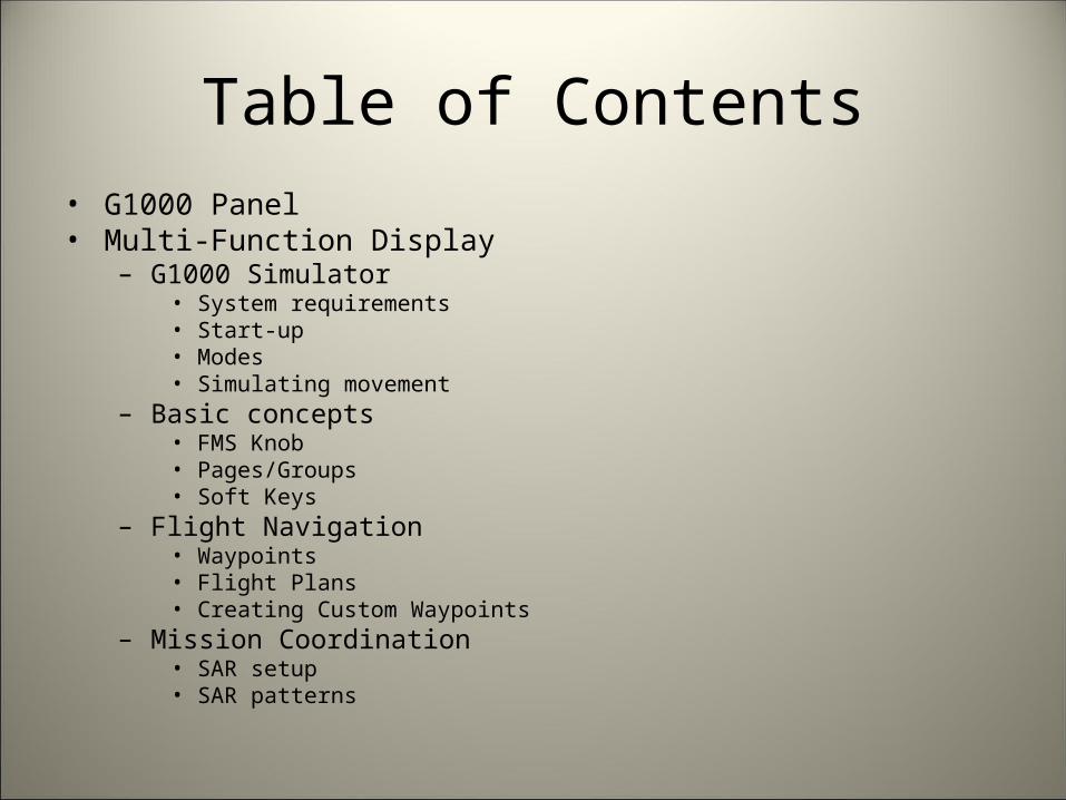
Table of Contents• G1000 Panel• Multi-Function Display
– G1000 Simulator• System requirements• Start-up• Modes• Simulating movement
– Basic concepts• FMS Knob• Pages/Groups• Soft Keys
– Flight Navigation• Waypoints• Flight Plans• Creating Custom Waypoints
– Mission Coordination• SAR setup• SAR patterns

CAP G1000 Panel

Primary Flight Display (PFD)

Multifunction Display (MFD)
For pilot use only
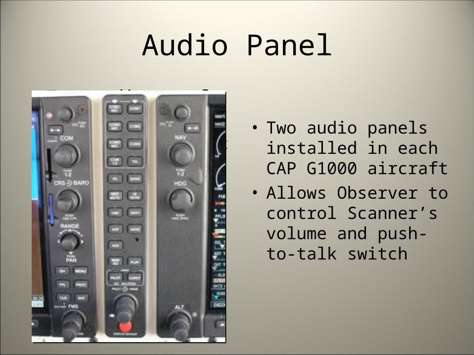
Audio Panel
• Two audio panels in CAP aircraft:– One for the pilot– One for observer
• Ideally, managed by the Observer
• Two audio panels installed in each CAP G1000 aircraft
• Allows Observer to control Scanner’s volume and push-to-talk switch

Direction Finder (“Becker”)
• Supports new 406MHz as well as 121.5MHz
• Easy to interpret
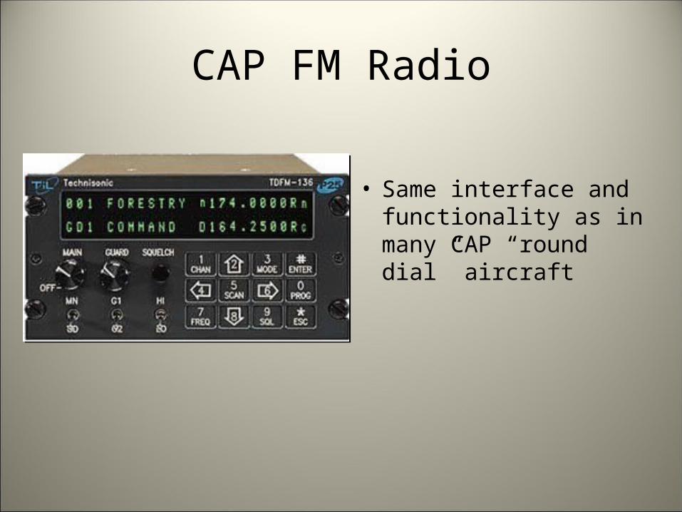
CAP FM Radio
• Same interface and functionality as in many CAP “round dial” aircraft
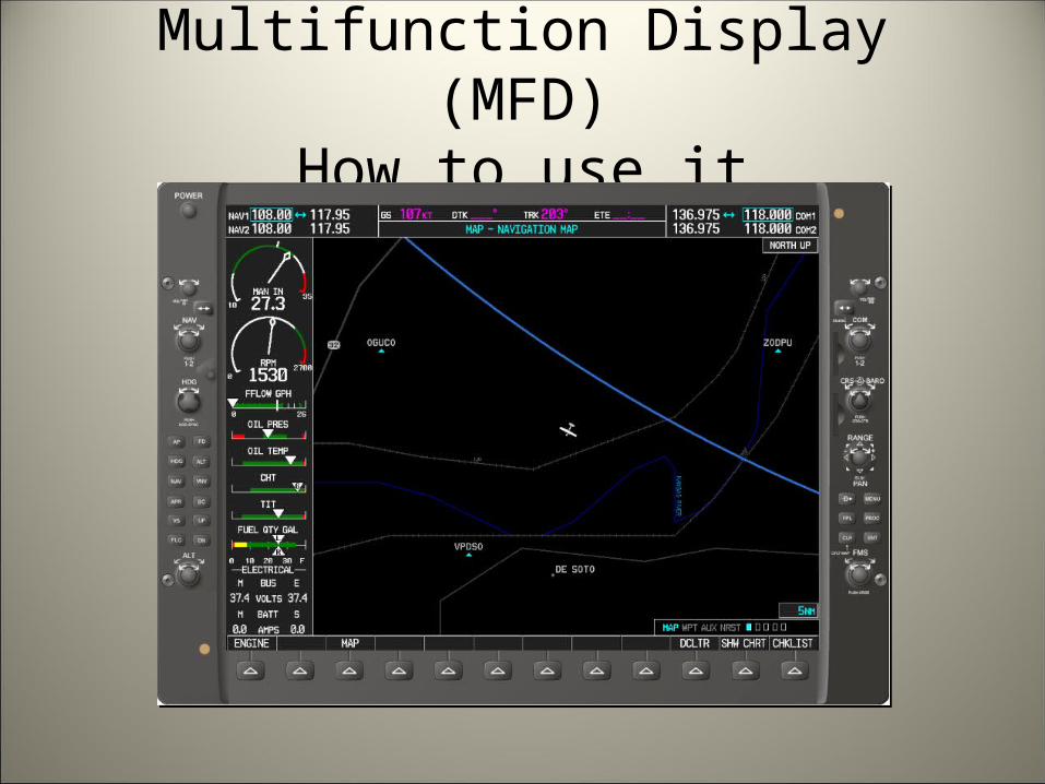
Multifunction Display (MFD)How to use it
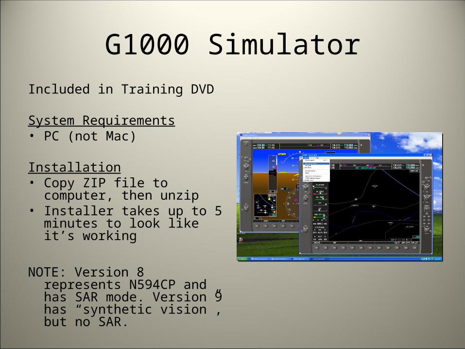
G1000 SimulatorIncluded in Training DVD
System Requirements• PC (not Mac)
Installation• Copy ZIP file to computer,
then unzip• Installer takes up to 5 minutes
to look like it’s working
NOTE: Version 8 represents N594CP and has SAR mode. Version 9 has “synthetic vision”, but no SAR.

G1000 Simulator Start-up
• First, select an airframe• Some airframes are buggy
and won’t switch to MFD mode; C-172R works well.
• In version 8.20, the C-182T has SAR.
• The “POWER” button starts the display.
• Joystick can be configured under “Options”

G1000 Simulator Modes
Displays• PFD• MFD• Dual-screen Trainer
(both PFD and MFD)
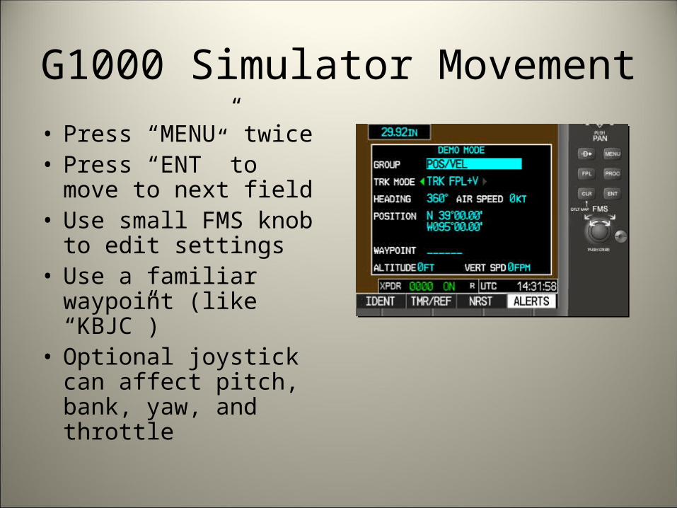
G1000 Simulator Movement
• Press “MENU” twice• Press “ENT” to move to
next field• Use small FMS knob to
edit settings• Use a familiar waypoint
(like “KBJC”)• Optional joystick can
affect pitch, bank, yaw, and throttle

FMS Knob and Enter Key
• FMS KnobTwist Outer knob
“Do something big”Twist Inner knob
“Do something small”Push Knob
Changes functionality of knob twisting (cursor on/off)
• Enter Key– “Okay”
• FMS KnobTwist Outer knob
“Do something big”Twist Inner knob
“Do something small”Push Knob
Changes functionality of knob twisting (cursor on/off)
• Enter Key– “Okay”

Page Groups vs. Individual Pages
• Page Groups– Maps– Waypoints– Auxiliary– Nearest– Flight Plan (accessed
differently than other page groups)
• Example Pages– Map Page Group:
• Navigation Map• Traffic Map• Weather Map
– Aux Page Group:• XM Radio• Setup

“Soft” Keys
• Soft keys are labeled differently on various screens
• Soft keys are labeled differently on various screens

Navigation

Waypoint
• A vertical line extending from the Earth’s surface upward.– Airport– Intersection– NDB– VOR– User-defined
Flight Plan
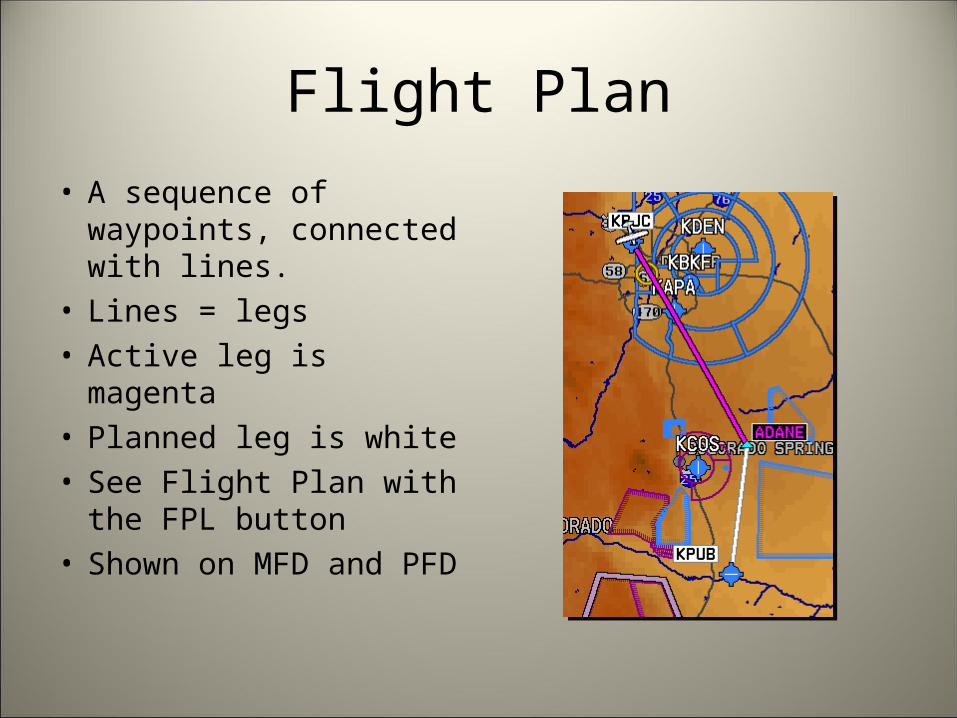
• A sequence of waypoints, connected with lines.
• Lines = legs• Active leg is magenta• Planned leg is white• See Flight Plan with the
FPL button• Shown on MFD and PFD
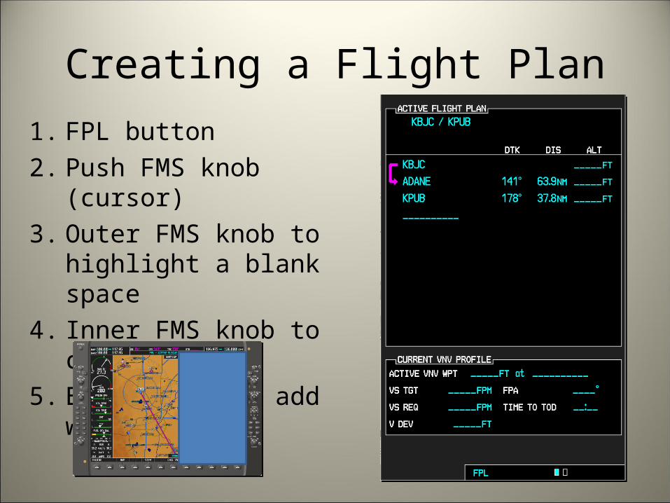
Creating a Flight Plan
1. FPL button2. Push FMS knob (cursor)3. Outer FMS knob to highlight
a blank space4. Inner FMS knob to change5. ENT button to add waypoint

Amending a Flight Plan1. Push FMS knob (cursor)2. Outer FMS knob to
highlight a waypointTo insert a waypoint:3. Inner FMS knob to enter
name of waypoint4. ENT button to confirm5. Inserts above highlighted
pointTo remove a waypoint:6. CLR to remove7. ENT button to confirm

Storing a Flight Plan
1. Go to FPL page 12. Ensure cursor is
deactivated3. Push MENU4. Outer FMS knob to
highlight “Store…”5. ENT button to confirm

Activating a Stored Flight Plan
• Go to second page of FPL page group
• Push FMS knob• Outer FMS knob to
highlight desired plan• ACTIVE soft key• ENT to confirm

Creating a Custom Waypointfrom Present Position
• Push the joystick (activates pointer at present location)
• Don’t rush; the marked point won’t move.
• Press ENT to save• Write down coordinates

Creating a Custom Waypointfrom Coordinates or Distance/Bearing
• Go to WPT page group• Go to USER WPT page• NEW soft key• Use inner and outer
FMS knobs, and ENT

Mission Coordination

SAR Observer Setup
• Essential Setup– North up– Lat/Lon and Data Bar
Display– Terrain height– Lat/Lon Grid lines shown
• Optional– Terrain overlay– Traffic overlay– Weather overlay

North-up1. FMS knob: NAVIGATION
MAP page2. MENU button3. FMS knob: Map Setup 4. ENT button5. FMS knob: Map GROUP
– North up– Track up– Desired Track (DTK) up– Heading (HDG) up
6. FMS knob: Push to deactivate cursor and exit

Lat/Lon and Data Bar Display
1. FMS knob: SYSTEM SETUP page (in the AUX group)
2. FMS knob: Push to activate cursor
3. FMS knob: Position: HDDD MM SS.S (in the DISPLAY UNITS area)
4. ENT button5. FMS knob: Push to
deactivate cursor

Terrain Height (MSL)
• FMS knob: NAVIGATION MAP page
• Joystick: Push to activate pointer
• Do some math• Joystick: Push to de-
activate pointer Waypoint “B”:•2.0nm away from you•Bearing 354 (to get there)•1,473 ft. MSL•Search altitude =1,473 ft. MSL + 1000 ft. AGL =2,473 ft. MSL
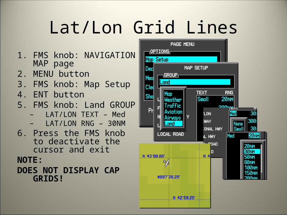
Lat/Lon Grid Lines1. FMS knob: NAVIGATION
MAP page2. MENU button3. FMS knob: Map Setup 4. ENT button5. FMS knob: Land GROUP
– LAT/LON TEXT – Med– LAT/LON RNG – 30NM
6. Press the FMS knob to deactivate the cursor and exit
NOTE:DOES NOT DISPLAY CAP GRIDS!

Optional Overlays
• Tools you will need during a mission:– Traffic overlay– Terrain overlay– Weather overlay
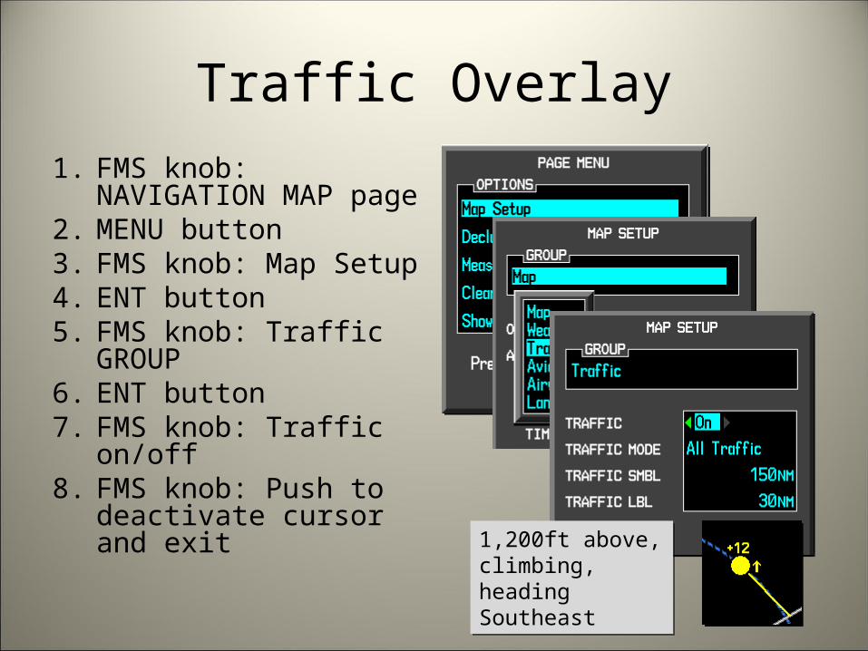
Traffic Overlay1. FMS knob: NAVIGATION
MAP page2. MENU button3. FMS knob: Map Setup 4. ENT button5. FMS knob: Traffic
GROUP6. ENT button7. FMS knob: Traffic on/off8. FMS knob: Push to
deactivate cursor and exit 1,200ft above,
climbing, heading Southeast
1,200ft above, climbing, heading Southeast
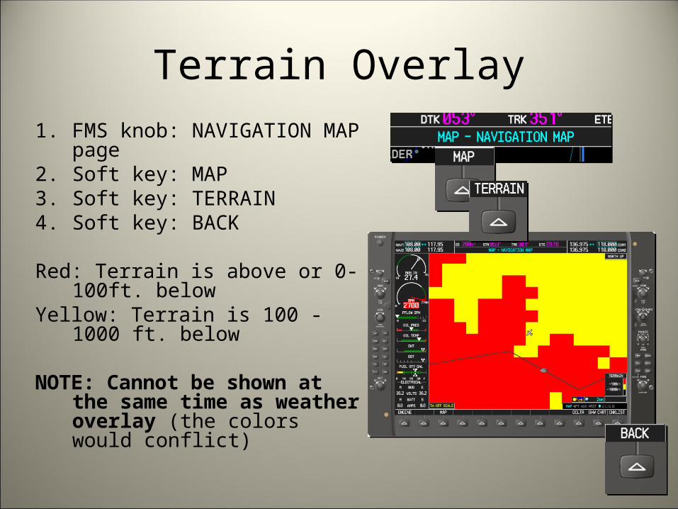
Terrain Overlay1. FMS knob: NAVIGATION MAP
page2. Soft key: MAP3. Soft key: TERRAIN4. Soft key: BACK
Red: Terrain is above or 0-100ft. belowYellow: Terrain is 100 - 1000 ft. below
NOTE: Cannot be shown at the same time as weather overlay (the colors would conflict)

Weather (NEXRAD) Overlay
1. FMS knob: NAVIGATION MAP page
2. Soft key: MAP3. Soft key: NEXRAD4. Soft key: BACKNOTE: Cannot be shown
at the same time as Terrain Overlay (the colors would conflict)
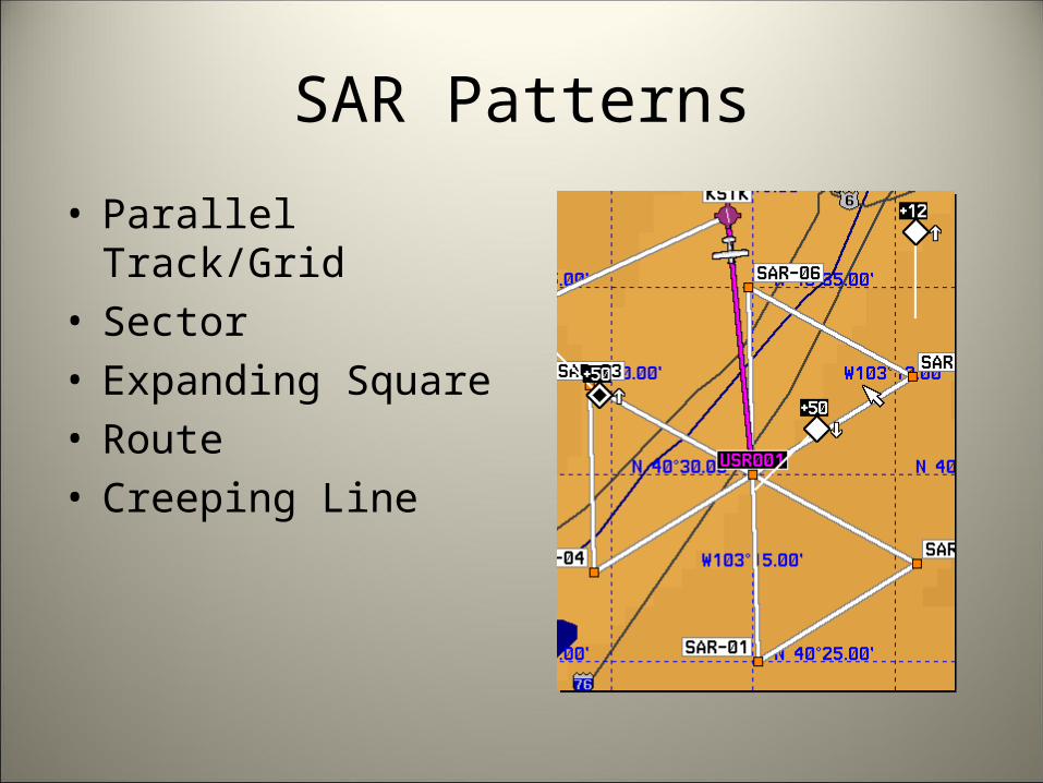
SAR Patterns
• Parallel Track/Grid• Sector• Expanding Square• Route• Creeping Line
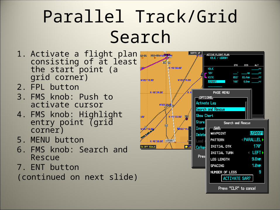
Parallel Track/Grid Search1. Activate a flight plan
consisting of at least the start point (a grid corner)
2. FPL button3. FMS knob: Push to activate
cursor4. FMS knob: Highlight entry
point (grid corner)5. MENU button6. FMS knob: Search and
Rescue7. ENT button(continued on next slide)

Parallel Track/Grid Search (cont’d)8. FMS knob:
– Waypoint: Entry Point– Pattern: Parallel– Initial DTK: Mag heading on
first leg (you correct for variation)
– Initial Turn: Left/right after entering search pattern
– Leg Length: 5NM - 7.5NM– Spacing: 1.0NM– Number of legs: 6 – 8
9. FMS knob: ACTIVATE SAR10. ENT button*NOTE: Will go direct-to entry
point

Sector Search1. Activate a flight plan
consisting of at least the start point
2. FPL button3. FMS knob: Push to
activate cursor4. FMS knob: Highlight entry
point (grid corner)5. MENU button6. FMS knob: Search and
Rescue7. ENT button(continued on next slide)
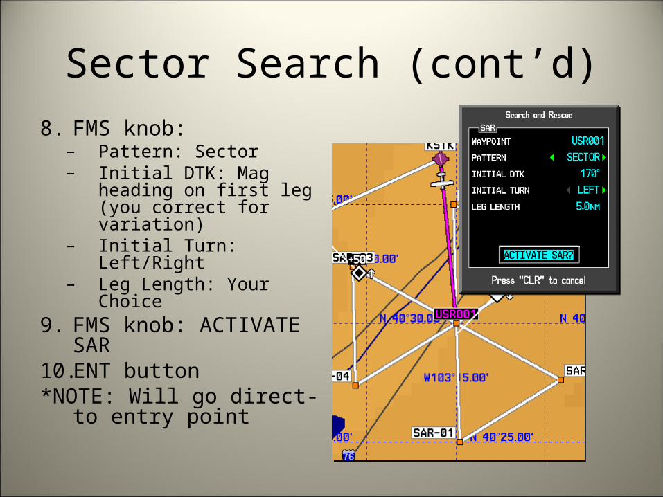
Sector Search (cont’d)8. FMS knob:
– Pattern: Sector– Initial DTK: Mag heading
on first leg (you correct for variation)
– Initial Turn: Left/Right– Leg Length: Your Choice
9. FMS knob: ACTIVATE SAR
10. ENT button*NOTE: Will go direct-to
entry point

Expanding Square Search1. Activate a flight plan
consisting of at least the start point
2. FPL button3. FMS knob: Push to
activate cursor4. FMS knob: Highlight entry
point (grid corner)5. MENU button6. FMS knob: Search and
Rescue7. ENT button(continued on next slide)

Expanding Square Search (cont’d)8. FMS knob:
– Pattern: Exp Sqr– Initial DTK: Mag heading
on first leg (you correct for variation)
– Initial Turn: Left/Right– Number of legs: Your
choice9. FMS knob: ACTIVATE
SAR10. ENT button*NOTE: Will go direct-to
entry point
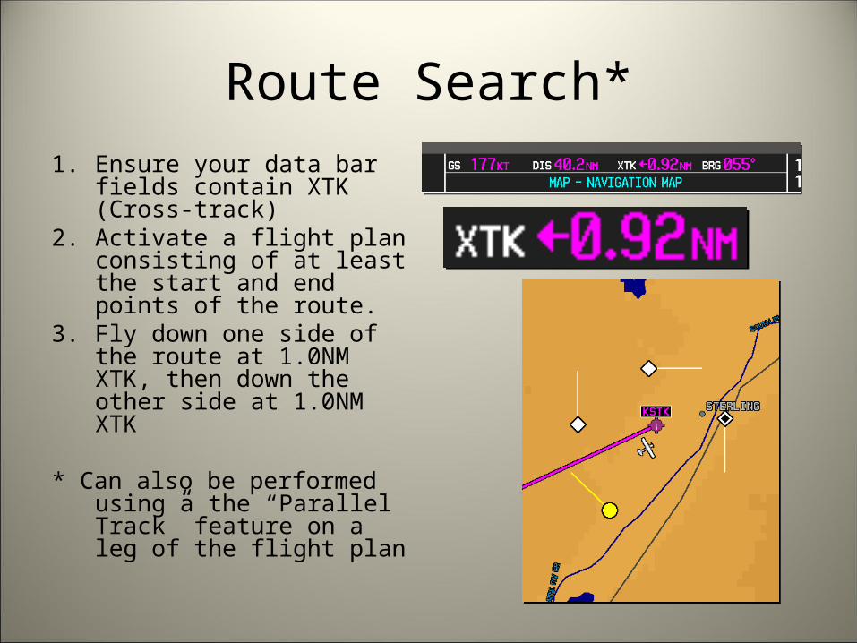
Route Search*1. Ensure your data bar fields
contain XTK (Cross-track)2. Activate a flight plan
consisting of at least the start and end points of the route.
3. Fly down one side of the route at 1.0NM XTK, then down the other side at 1.0NM XTK
* Can also be performed using a the “Parallel Track” feature on a leg of the flight plan

Creeping Line SearchThis is really just a parallel track
pattern with different dimensions
1. Find DTK between start point and end point by entering that leg in the flight plan
2. FMS knob: Highlight beginning waypoint
3. MENU button4. FMS knob: Search and
Rescue5. ENT button(continued on next slide)
DTK = 245

Creeping Line Search6. FMS knob:
– Pattern: Parllel– Initial DTK: 90 degrees from
the DTK between waypoints– Initial Turn: Left or Right
depending on whether you added or subtracted 90 degrees
– Leg Length: 5.0NM– Spacing: 2.0NM– Number of legs: A few
dozen7. FMS knob: ACTIVATE SAR8. ENT button
DTK = 245Initial DTK = 254-90Initial DTK = 155Turns = Right turns, because we subtracted 90 degrees from the DTK

Revision HistoryDate Who ID Notes
12 Dec 2009 1st Lt Todd Gamber CAPID 443746
v1 Initial Revision
07 Mar 2010 1st Lt Todd Gamber CAPID 443746
v2 - Added a “Simulator” section- Fixed an error in “Amending a Flight Plan” instructions-Fixed an error in “Storing a Flight Plan” instructions-Fixed logic error in formulas for calculating proper grid width on Parallel Track Search slide-Fixed screen shot for picking Latitude/Longitude representation in AUX page group (incorrect representation was highlighted; was misleading)-Added a picture of the Technisonic FM radio-Fixed misc text formatting/overlapping issues-Added a note that the Route Search can be performed using some other methods.
09 Apr 2010Next revision expected 07 Jul 2010
1st Lt Todd GamberCAPID 443746
v3 -Moved revision history to second page instead of first page-Noted that the Flight Plan page group is accessed differently than other page groups (on “Page Groups vs. Individual Pages” slide)-Exclaimed that G1000 does not display CAP grids

Revision History (cont’d)Date Who ID Notes
10 Apr 2011 1st Lt Todd GamberCAPID 443746
v4 -Replaced the ambiguous term “knobs:” with “FMS knob:” in several places-Added instruction slides for Creeping Line search-Moved revision history to the end of the slideshow