Embed Size (px)
Citation preview

FUNCTIONAL WATER, WASTEWATER AND STORMWATER DRAINAGE REPORT
Milton Meadows Properties Inc. (Royalpark North)
24T-07002 / Re-zoning Z-02/07
1321387 Ontario Inc. (Century Grove)
24T-07003 / Re-zoning Z-03/07
SIS Areas 1 & 2 - North of Sixteen Mile Creek
Town of Milton
Regional Municipality of Halton
Prepared for
Royalpark North / Century Grove
Project #: 10-334
March 2013

10-334-FSR - March 2013 - Royalpark & Century Grove Page ii
Urbantech Consulting, A Division of Leighton-Zec Ltd. 25 Royal Crest Court, Suite 201 Markham, Ontario L3R 9X4
TEL: 905.946.9461 FAX: 905.946.9595 www.urbantech.com
Table of Contents
1. BACKGROUND ............................................................................................. 1
2. EXISTING CONDITIONS .............................................................................. 3
2.1. EXISTING LAND USE ......................................................................................... 3 2.2. EXISTING TERRESTRIAL AND AQUATIC FEATURES .................................................... 3 2.3. EXISTING WATERCOURSE CHARACTERISTICS .......................................................... 3 2.4. GEOTECHNICAL STUDY ...................................................................................... 4 2.5. EXISTING INFRASTRUCTURE / CONSTRAINTS .......................................................... 5
3. SITE GRADING ............................................................................................ 6
3.1. GRADING CONSTRAINTS .................................................................................... 6
4. EXTERNAL ROAD WORKS ............................................................................ 7
5. STORM DRAINAGE ....................................................................................... 8
5.1. PRE-DEVELOPMENT STORM DRAINAGE .................................................................. 8 5.2. POST-DEVELOPMENT STORM DRAINAGE ................................................................ 9
5.2.1. External Drainage Areas ......................................................................... 9 5.2.2. Minor System Drainage ........................................................................ 10 5.2.3. Major System Drainage ........................................................................ 10 5.2.4. Service Connections ............................................................................. 10
6. STORMWATER MANAGEMENT ................................................................... 11
6.1. PREVIOUS STUDY RECOMMENDATIONS ................................................................ 11 6.2. SWM FACILITY DESIGN .................................................................................. 12
6.2.1. SWM Facility Grading Criteria ................................................................ 13 6.3. FACILITY COMPONENTS ................................................................................... 14
6.3.1. Sediment Forebay ................................................................................ 14 6.3.2. Maintenance Access Road .................................................................... 14 6.3.3. SWM Facility Outfall ............................................................................. 15 6.3.4. Thermal Mitigation ............................................................................... 15
6.4. OPERATIONS AND MAINTENANCE ....................................................................... 18
7. CHANNEL NW-2-G1 REALIGNMENT & NATURAL HERITAGE SYSTEM....... 19
7.1. NATURAL CHANNEL DESIGN CRITERIA ................................................................ 19 7.2. CHANNEL HYDRAULICS .................................................................................... 20
7.2.1. Riparian Storage .................................................................................. 20 7.2.2. Existing Flood Plain .............................................................................. 21 7.2.3. Proposed Crossings .............................................................................. 21 7.2.4. Proposed Water Levels ......................................................................... 22
7.3. CONSTRUCTION STAGING ................................................................................ 22 7.4. GROUNDWATER MANAGEMENT PLAN .................................................................. 22 7.4 NATURAL HERITAGE SYSTEM ............................................................................ 22
8. WASTEWATER SERVICING ........................................................................ 23

10-334-FSR - March 2013 - Royalpark & Century Grove Page iii
Urbantech Consulting, A Division of Leighton-Zec Ltd. 25 Royal Crest Court, Suite 201 Markham, Ontario L3R 9X4
TEL: 905.946.9461 FAX: 905.946.9595 www.urbantech.com
9. WATER DISTRIBUTION ............................................................................. 24
10. SIDEWALK NETWORK ............................................................................... 25
11. PROPOSED ROAD CROSS SECTIONS AND LANEWAYS .............................. 26
11.1. LANEWAYS (11M ROW) .................................................................................. 26 11.2. LOCAL ROADS (16M ROW) ............................................................................. 26 11.3. 3RD SIDE ROAD (20M ROW) ............................................................................ 26 11.4. NEW TREMAINE ROAD / INTERCHANGE ............................................................... 26
12. PHASING.................................................................................................... 27
13. EROSION AND SEDIMENT CONTROL DURING CONSTRUCTION ............... 28
14. CONCLUSIONS ........................................................................................... 29
Tables
Table 2-A – Existing Channel Conditions Based on Field Observations ........................... 3 Table 6-A – SWM Facility Target Volume and Release Rate ........................................ 12 Table 6-B – SWM Facility S43 Design Requirements ................................................... 12 Table 6-C – SWM Facility S44 Design Requirements ................................................... 13 Table 6-D – Preliminary Facility S43 Design ............................................................... 14 Table 6-E – Preliminary Facility S44 Design ............................................................... 14 Table 6-F – Thermal Mitigation Alternatives ............................................................... 16 Table 7-A – Natural Channel Design Parameters ........................................................ 20 Table 7-B – Riparian Storage Analysis ....................................................................... 21
Figures Figure 1 Site Location Figure 2 Grading Concept Figure 3.1 Pre-Development Drainage Plan Figure 3.2 Post-Development Drainage Plan Figure 3.3 Major Storm System Drainage Plan Figure 4 Stormwater Management Facility S43 Figure 5 Stormwater Management Facility S44 Figure 6 Sanitary Drainage Plan Figure 7 Watermain Concept Plan Figure 8 Sidewalk Location Plan Figure 9 3rd Side Road Cross Section Figure 10 Existing Flood Mapping Figure 11 Proposed Flood Mapping Figure 12 Royalpark North Preliminary Phasing Plan Figure STG 1 – 4 NW-2G1 Channel Construction Staging Plans (Stages 1 to 4)

10-334-FSR - March 2013 - Royalpark & Century Grove Page iv
Urbantech Consulting, A Division of Leighton-Zec Ltd. 25 Royal Crest Court, Suite 201 Markham, Ontario L3R 9X4
TEL: 905.946.9461 FAX: 905.946.9595 www.urbantech.com
Appendices
Appendix A – Geotechnical Investigation Appendix B – Milton Heights Neighbourhood NW-2-G1 Channel Realignment Groundwater Management Plan Appendix C – Storm Sewer and SWM Design Sheets Appendix D – Sanitary Sewer Design Sheets Appendix E – Water Distribution Analysis (GENIVAR) Appendix F – Existing & Proposed HEC-RAS Model results Appendix G – 3rd Side Road Technical Memo (HDR | iTRANS)

10-334-FSR - March 2013 - Royalpark & Century Grove Page 1
Urbantech Consulting, A Division of Leighton-Zec Ltd. 25 Royal Crest Court, Suite 201 Markham, Ontario L3R 9X4
TEL: 905.946.9461 FAX: 905.946.9595 www.urbantech.com
1. BACKGROUND
The 1321387 Ontario Inc. (Century Grove) and Milton Meadows Properties Inc. (Royalpark North) draft plans of subdivision fall within the Sherwood Secondary Plan Area Phase 2-C, in the Town of Milton. These draft plans are bounded by Tremaine Road to the west, Peru Road to the east, Highway 401 to the north, and Sixteen Mile Creek to the south. The draft plans numbers are as follows: Milton Meadows Properties Inc. (Royalpark North) - 24T-07002 / Re-zoning Z-02/07 1321387 Ontario Inc. (Century Grove) - 24T-07003 / Re-zoning Z-03/07 These properties are hereafter referred to as the “proposed development”. The proposed development falls within the Sixteen Mile Creek subwatershed areas 1 and 2. Additional development is proposed south of Sixteen Mile Creek to Steeles Avenue; these lands are described under separate draft plans. Please refer to Figure 1 for the site location and draft plan areas. The proposed development will include mixed residential, mixed use / commercial and open space blocks. The development concepts presented in this submission are an extension of the information contained in the following studies and reports: Milton Heights Neighbourhood NW-2-G1 Channel Re-alignment Groundwater
Management Plan, prepared by R.J. Burnside and AMEC Environment and Infrastructure (October 2011)
Subwatershed Impact Study – Areas 1,2,3 and 4, prepared by RAND Engineering and
Beacon Environmental Limited (August 2009)
Indian Creek/Sixteen Mile Creek, Sherwood Survey, Subwatershed Management Study, Town of Milton, prepared by Philips Engineering Limited (December 2004)
Milton Urban Expansion Conceptual Fisheries Plan, Phase 2 Area, Sherwood Survey, prepared by Philips Engineering Limited (December 2004)
Sherwood Survey Secondary Plan and Related Official Plan Amendments, Town of Milton, consolidated November 2005

10-334-FSR - March 2013 - Royalpark & Century Grove Page 2
Urbantech Consulting, A Division of Leighton-Zec Ltd. 25 Royal Crest Court, Suite 201 Markham, Ontario L3R 9X4
TEL: 905.946.9461 FAX: 905.946.9595 www.urbantech.com
Tremaine Road & James Snow Parkway Transportation Corridor Improvements Class EA Study, prepared by McCormick Rankin (November 2007)
3rd Side Road Technical Memorandum, prepared by HDR | iTRANS (April 2010)
MTO Drainage Management Technical Guidelines, Ontario Ministry of Transportation (November 1989)
Stormwater Management and Design Manual (SWMP) by Ministry of Environment (March 2003)
Municipal services for this subdivision will be designed to comply with the latest standards and criteria prepared by the Town of Milton (roads, grading and storm drainage) and the Regional Municipality of Halton (water distribution and sanitary drainage). Conservation Halton, MOE, and MNR recommendations were incorporated into the design of the SWM facilities and channel realignment. A number of additional studies are to be refined / completed prior to detailed design, including a detailed channel design report, a noise/vibration report, the detailed design of the Highway 401/New Tremaine Road interchange, forestry, and a detailed geotechnical investigation.
10-334-FSR - March 2013 - Royalpark & Century Grove Page 3
Urbantech Consulting, A Division of Leighton-Zec Ltd. 25 Royal Crest Court, Suite 201 Markham, Ontario L3R 9X4
TEL: 905.946.9461 FAX: 905.946.9595 www.urbantech.com
2. EXISTING CONDITIONS
2.1. Existing Land Use
The existing land use in the area of proposed development is classified as a combination of natural, semi-natural, and agricultural/developed, based on aerial photo interpretation and site visits. There are some existing residential properties on the site, as well as roads and culverts servicing the agricultural fields and the respective drainage.
2.2. Existing Terrestrial and Aquatic Features
Several forest, cultural meadow, woodland, and wetland features have been identified in the SIS study (refer to Figure 2.1 of the RAND SIS). Wildlife characterization included breeding bird, mammal, and amphibian surveys. Aquatic features including Redside dace habitat were investigated and sampled for various species. Please refer to Section 5.1 for stream classification, and the RAND SIS for survey results.
2.3. Existing Watercourse Characteristics
A detailed geomorphic assessment of Sixteen Mile Creek in the proposed residential development area was undertaken by Aquafor Beech in 2007 and additional data was collected in 2011. It was found that the channel reach upstream and downstream of No. 3 Side Road was modified (straightened) prior to 1946, presumably to accommodate agricultural activity. The channel downstream of Highway 401 to No. 3 Side Road has predominantly sand along the channel bed but there are locations of gravel and cobble (introduced). The channel is mildly sinuous due to meander initiation. There are areas where the bank is undercut and roots are exposed. Vegetation adjacent to the channel consists mostly of wooded vegetation in a narrow buffer (less than 10m to approximately 27m). It is moderately connected to the floodplain. The channel bed from No. 3 Side Road to Peru Road contains sand, gravel, organics, and grasses and is channelized (straight) with uniform cross sections. There is subtle bed morphology along this section of the channel and sections seem highly vegetation controlled; indeed, vegetation chokes the channel in several areas. This section is very well connected to the floodplain (i.e. cultivated fields). Table 2-A – Existing Channel Conditions Based on Field Observations
Parameter Highway 401 to No. 3 Side Road
No. 3 Side Road to Peru Road
Bankfull depth [m] 0.60 to 0.70 0.40 to 0.90
Bankfull top width [m] 1.5 to 5.0 1.5 to 5.0
Meander belt slope % 0.56 and 0.23% 0.45%
Meander belt width [m] 33 34

10-334-FSR - March 2013 - Royalpark & Century Grove Page 4
Urbantech Consulting, A Division of Leighton-Zec Ltd. 25 Royal Crest Court, Suite 201 Markham, Ontario L3R 9X4
TEL: 905.946.9461 FAX: 905.946.9595 www.urbantech.com
2.4. Geotechnical Study
A geotechnical / hydrogeological investigation was conducted by AMEC Earth & Environmental in support of the Milton Heights SIS to assess site soils, groundwater table, and related design requirements. The results of the geotechnical report are included in the August 2009 SIS. An additional study was completed by R.J. Burnside in association with AMEC in October 2011. This study identified the groundwater management recommendations for channel construction and will be referenced in the detailed channel design report for the re-alignment works. In general, the findings of the studies indicated the following:
The subject property (SIS Area 1, north of 3rd Side Road) consists of silty clay / clayey silt till mixed with silty sand/ sandy silt. The groundwater table depth was estimated to be 2 to 3m below the existing ground for most of the area.
The subject property (SIS Area 2, south of 3rd Side Road) consists of a 0.50m layer of
topsoil over top layers of silty sand/clayey silt/silt clay and silty clay/clayey silt/sandy silt till. The observed groundwater table in the vicinity of the Sixteen Mile Creek Corridor was 0.8m to 1.2m below existing grade. Towards the center of the site, the water table was measured at 3.7m below existing grade.
The subject property (SIS Area 2, south of 3rd Side Road) consists of a 0.25m to 0.46m
depth of topsoil over top layers of clayey silt/sand and clayey silt/silty clay till and sand/sandy silt till. The observed groundwater table was measured at depths ranging from 2.7m to 4.4m below the existing ground surface.
Excavations will encounter wet soil conditions, particularly in the spring and fall. However, despite the high water table observed at various times of the year, the surficial soils are predominantly silty clay till and this low-hydraulic conductivity material does not produce much water.
Due to the nature of the surficial sediments (till soils), significant dewatering is not anticipated to be required to complete the proposed channel construction, although minor groundwater seepage into the excavation may occur. An appropriate groundwater management plan, including monitoring / inspection recommendations and contingency actions will be further described in the detailed channel design report.

10-334-FSR - March 2013 - Royalpark & Century Grove Page 5
Urbantech Consulting, A Division of Leighton-Zec Ltd. 25 Royal Crest Court, Suite 201 Markham, Ontario L3R 9X4
TEL: 905.946.9461 FAX: 905.946.9595 www.urbantech.com
2.5. Existing Infrastructure / Constraints
The following existing services are present on or adjacent to the site as indicated on Figure 6 (sanitary) and Figure 7 (water main):
Well-based water supply main runs west to east across the north side of the site from Tremaine Road to Peru Road and Highway 401 (Magna industrial site)
Well-based water supply main on 3rd Side Road, Peru Road, and Tremaine Road Gas utilities along Peru Road north of 3rd Side Road Existing sanitary sewer on Peru Road south of the proposed development.
The 675mm sanitary sewer recently extended by the Region from Market Drive to Peru Road will be extended north to service the proposed development as shown on Figure 6. The existing well-based watermain through the subject lands is to be decommissioned and removed as agreed with the Region of Halton, while the watermain on Peru Road is to be relocated to accommodate the proposed realignment of the NW-2-G1 reach as shown on Figure 7. The existing gas main north of 3rd Side Road will also be relocated and will be placed within SWM Block S43 due to the NW-2-G1 realignment.

10-334-FSR - March 2013 - Royalpark & Century Grove Page 6
Urbantech Consulting, A Division of Leighton-Zec Ltd. 25 Royal Crest Court, Suite 201 Markham, Ontario L3R 9X4
TEL: 905.946.9461 FAX: 905.946.9595 www.urbantech.com
3. SITE GRADING
The site will be graded in a manner consistent with its existing topographic features and will satisfy the following objectives: Minimize cut to fill operations Reduce or eliminate the need for retaining walls Maintain general landform character Provide minimal impact to abutting properties Achieve stormwater management /environmental objectives required for the site Provide overland flow conveyance for major storm conditions Provide adequate cover above proposed servicing
The subdivision will be graded to suit the Town of Milton’s design criteria and will consider constraints imposed by storm drainage, the proposed NW-2-G1 channel realignment, and boundary roads. Proposed road grades will utilize the Town of Milton minimum 0.50% slope. If required at detailed design, sawtooth grading will be introduced to minimize the extent of fill on the site. Sawtooth road grading conforms to the Town’s minimum 0.50% road grade, however, the net grade over an extended length of road is reduced by introducing sections of road reversed graded at 0.20%. The net slope will accommodate major system flow conveyance. Please refer to Figure 2 for preliminary site grading and overland flow routes.
3.1. Grading Constraints
The following constraints have been taken into account for site grading:
Existing roads including Tremaine Road, Peru Road, 3rd Side Road, and existing residential properties north and south of 3rd Side Road
Future roads including: o proposed Tremaine Road overpass, o Peru Road closure and maintenance access road to gas and water infrastructure
west of Magna property, o future 3rd Side Road urbanization o Highway 401/MTO property boundary and setbacks, ramps, and future New
Tremaine alignment Future NW-2-G1 alignment and geomorphologic considerations (meander belt, buffers,
etc.) Accommodation of existing external drainage areas Permanent pool elevation for SWM facilities governed by proposed channel invert
elevation Groundwater table elevation relative to services, channel, and proposed basements

10-334-FSR - March 2013 - Royalpark & Century Grove Page 7
Urbantech Consulting, A Division of Leighton-Zec Ltd. 25 Royal Crest Court, Suite 201 Markham, Ontario L3R 9X4
TEL: 905.946.9461 FAX: 905.946.9595 www.urbantech.com
4. EXTERNAL ROAD WORKS
The closure of Peru Road north of 3rd Side Road and the urbanization of 3rd Side Road will be further described at the detailed design phase. Several road construction projects are proposed in conjunction with the site development. These works will be designed by others and the designs will be coordinated with the proposed development. These road works include:
Construction of the New Tremaine Road alignment through the site Construction of an interchange connecting the proposed New Tremaine Road to
Highway 401 Potential lowering and removal of existing Tremaine road overpass across Highway 401
The segment of the proposed New Tremaine Road ROW north of 3rd Side Road will drain to SWM Facility S43, while the segment between 3rd Side Road and Sixteen Mile Creek will drain to SWM Facility S44. Note that the development of the 1321387 Ontario Inc. (Century Grove) lands is not tied to the completion of the Peru Road works, since the 1321387 Ontario Inc. lands can be serviced via infrastructure not related to the Peru Road closure.

10-334-FSR - March 2013 - Royalpark & Century Grove Page 8
Urbantech Consulting, A Division of Leighton-Zec Ltd. 25 Royal Crest Court, Suite 201 Markham, Ontario L3R 9X4
TEL: 905.946.9461 FAX: 905.946.9595 www.urbantech.com
5. STORM DRAINAGE
The proposed development is within the catchment area for the Sixteen Mile Creek Subwatershed, particularly the NW-2-E, NW-2F, and NW-2-G1 tributary subcatchments. This submission advances the recommendations in the previously approved Sherwood Survey Subwatershed Management Study for SIS Areas 1,2,3 and 4.
5.1. Pre-Development Storm Drainage
Figure 3.1 depicts the pre-development drainage areas for the Milton Heights lands. The site is presently drained by the NW-2-E, NW-2-F, and NW-2-G1 watercourses, which have a confluence north of 3rd Side Road. Sixteen Mile Creek (NW-1-A) runs west to east across the southernmost boundary of the subject site. The subject site drains in a north to south direction, towards Sixteen Mile Creek, while the internal subcatchments drain towards the aforementioned watercourses. The watercourses on the site were assigned constraint rankings in the Indian Creek/Sixteen Mile Creek Subwatershed Study (Philips Engineering Limited, 2004). NW-2-E flows north to south and conveys drainage from 62.6ha of agricultural fields north of Highway 401 through an existing 2.0m x 1.2m box culvert. This watercourse does not convey runoff from the highway. NW-2-E has been designated as low constraint due to the ephemeral flow regime, lack of channel definition, and absence of fish habitat. NW-2-F is an agricultural swale which flows in a west to east direction and partially encroaches on the subject property. This tributary is fed primarily by an external drainage area of 53.1ha west of Tremaine Road, which drains into the site via a 600mm diameter CMP culvert. This feature has been identified as a low constraint watercourse due to ephemeral conditions and lack of definition and habitat. It will be removed upon development of the site. The external flows will be directed into the realigned NW-2-G1 tributary, as discussed in Section 5.2.1. NW-2-G1 flows north to south through the site and changes direction close to Sixteen Mile Creek to cross Peru Road from the west. This tributary continues east between the Magna property and the future development area. NW-2-G1 has been designated as a high constraint stream, due to the suspected presence of Redside dace. Furthermore, this tributary has permanent flow, possibly due to a large external area of 158.2ha from north of Highway 401 as well as from groundwater input. The tributary east of Peru Road has already been realigned and naturalized.

10-334-FSR - March 2013 - Royalpark & Century Grove Page 9
Urbantech Consulting, A Division of Leighton-Zec Ltd. 25 Royal Crest Court, Suite 201 Markham, Ontario L3R 9X4
TEL: 905.946.9461 FAX: 905.946.9595 www.urbantech.com
As discussed in the preceding text, the following external drainage areas contribute runoff to the existing site:
62.6ha from north of Highway 401 drains via a 2.0m x 1.2m box culvert into NW-2-E.
53.1ha from west of Tremaine Road drains via a 600mm diameter CMP culvert into NW-2-F.
158.2ha north of Highway 401 drains via a 3.05m x 1.52m box culvert to NW-2-G1
5.2. Post-Development Storm Drainage
Several drainage adjustments have been proposed due to the removal of the low constraint watercourse features throughout the subject lands and the construction of the new Tremaine Road alignment. The post development drainage areas and proposed NW-2-G1 channel realignment are shown on Figure 3.2.
5.2.1. External Drainage Areas Drainage from the existing external areas will be accommodated in the proposed drainage design. The NW-2-E tributary area of 62.6ha will be directed into the realigned NW-2-G1, which will be adjacent to the Highway 401 corridor. Conveyance of these flows through the MTO lands will be determined during the interchange design. The 5-year flows from the 53.1ha drainage area west of Tremaine Road will be captured into a 1050mm running south to north along the Tremaine Road ROW within the subject lands. The pipe will also pick up foundation drain connections from the proposed lots on the west side of the property. This pipe will discharge clean, cool water into the upstream reach of NW-2-G1. The existing 158.2ha drainage area north of Highway 401 will continue to contribute to the NW-2-G1 watercourse. External drainage areas are indicated on Drawing 3.2

10-334-FSR - March 2013 - Royalpark & Century Grove Page 10
Urbantech Consulting, A Division of Leighton-Zec Ltd. 25 Royal Crest Court, Suite 201 Markham, Ontario L3R 9X4
TEL: 905.946.9461 FAX: 905.946.9595 www.urbantech.com
5.2.2. Minor System Drainage The proposed development will be serviced by a conventional storm sewer system designed in accordance with Town of Milton standards. The storm sewers will be sized based to the 5-year return frequency based on the Town of Milton IDF curves. Storm sewer design sheets are provided in Appendix C. The minor system layout is indicated on Figure 3.2. The minor system will have two outlets, namely SWM facility S43 north of 3rd Side Road, and SWM facility S44, adjacent to Peru Road near the southern limit of the site. The proposed S43 and S44 SWM facilities will provide water quality, erosion and quantity control for the subject lands and will discharge to NW-2-G1 and NW-1-A (Sixteen Mile Creek), respectively. The SWM facility design is outlined in Section 6.
5.2.3. Major System Drainage A continuous overland flow route will be provided through the subject lands where possible to safely convey major system flows in excess of the minor system up to the hundred year event. High capacity inlets will be provided where overland flow cannot be conveyed. Overland flow will be directed to the proposed SWM facilities S43 and S44 where possible. The major system flow will not exceed the width of the road allowance, and in no case will the depth of flow exceed 0.10 metres above the crown of the road in accordance with Town of Milton standards. Should the major system flows exceed the conveyance capacity of the roadway, the storm sewer will be sized to accommodate the excess flows. Please refer to Figure 3.2 for preliminary storm concept, Figure 2 for the grading plan which illustrates major system flow direction, and Figure 3.3 for major system capture areas.
5.2.4. Service Connections Due to grading constraints of the site, it may not be possible to supply a gravity outlet to drain all basement foundation drains. As per Town of Milton Standards, the development will require sump pumps which will outlet to a storm service connection for front draining lots and to the rear-yards (surface) for split-draining lots. A block of lots immediately north east of the 3rd Side Road and Tremaine Road intersection will be provided with a shallower, local sanitary sewer to facilitate service connections, as opposed to connecting to the much deeper (7m+) sanitary sewer on 3rd Side Road. Figure 9 demonstrates that the additional location sanitary sewer can be accommodated in the 3rd Side Road ROW.

10-334-FSR - March 2013 - Royalpark & Century Grove Page 11
Urbantech Consulting, A Division of Leighton-Zec Ltd. 25 Royal Crest Court, Suite 201 Markham, Ontario L3R 9X4
TEL: 905.946.9461 FAX: 905.946.9595 www.urbantech.com
6. STORMWATER MANAGEMENT
6.1. Previous Study Recommendations
Stormwater runoff from urban areas transports pollutants as dissolved loads, suspended loads, and as bed loads to the natural stream and river systems, where they can adversely impact the natural ecosystem. The Ministry of Environment (MOE) has developed technical guidelines for the quality control of stormwater runoff from new developments [ref. MOE, 2003]. These guidelines, along with the background study findings, provide recommendations for protecting the receiving watercourses and natural features from the impacts of stormwater runoff. The SIS provides an assessment of the potential impacts of stormwater runoff within the Sixteen Mile Creek subwatershed area associated with the proposed land use change. The SIS and SUS discussed the hydrological basis for the required flood control volumes for the 25-year and 100-year storm events. The targets determined in the SWS were applied to the current land use proposal and drainage boundaries and are provided in Table 6-A. Regional storm control is not required but conveyance through the major SWM block into the channel is required. At detailed design, the outlet structure and emergency spillway / inlets will be sized appropriately to meet these targets. The RAND Engineering / Beacon Environmental SIS for the subject lands concluded that the following shall be provided for all new developments: Stormwater Quality / Quantity storage be provided throughout development area for all
new development areas. On site controls would be required for all infill development areas less than 5 hectares. Generally limit the drainage area to SWM facilities to a maximum of 40 to 80 ha. Thermal mitigation practices should be incorporated into all stormwater management
facilities. The SIS suggested a total of 4 facilities would be required to service the site, including 2 wetlands and 2 wet ponds. A feasibility study prepared by Urbantech Consulting (May 2010) demonstrated that the 4 facilities could be consolidated into 2 wet facilities to reduce SWM infrastructure requirements. The SIS concludes that SWM facilities within the subject lands must practice stormwater management as indicated in Table 6-A.

10-334-FSR - March 2013 - Royalpark & Century Grove Page 12
Urbantech Consulting, A Division of Leighton-Zec Ltd. 25 Royal Crest Court, Suite 201 Markham, Ontario L3R 9X4
TEL: 905.946.9461 FAX: 905.946.9595 www.urbantech.com
Table 6-A – SWM Facility Target Volume and Release Rate
Criteria Target Volume Target Release Rate [m3/imp ha] [m3/s/ha]
Permanent Pool 170m3/ha for 64%IMP / 197m3/ha for 77%IMP* Extended detention 315 0.0011 25-yr quantity control 481 (315 + 166) 0.0094 100-yr quantity control 566 (315 + 166 + 85) 0.0155 Regional quantity control Not required Not required
*Based on MOE SWM Planning & Design Manual Table 3.2
6.2. SWM Facility Design
Both SWM facilities will be designed as wet pond and will include the following features: Sediment Forebay: To improve sediment removal prior to entering the wetland Permanent Pool: To trap pollutants and buffer storm flows Extended Detention Storage: To provide water quality and erosion control Quantity Control Storage: To attenuate post development flows to the allowable release
rates in accordance with the Subwatershed Study. The proposed SWM facilities are to be designed based on the target rates provided in Table 6-A and the contributing drainage areas indicated on Drawing 3.2. The pond sizing calculations have accounted for the contributing pond block area as well. Table 6-B – SWM Facility S43 Design Requirements
Criteria Design Requirement
Facility Type Wet pond
SIS Area 1
Drainage Area (ha) 32.2
Impervious Area (%) 64
Permanent Pool Storage (m3) 5,741
Extended Detention Storage (m3) 6,794
25-YR Storage (m3) 10,374
100-YR Storage (m3) 12,207
Total Quantity Storage (m3) 12,207
Extended Detention Flow (m3/s) 0.037
25-YR Storm Flow (m3/s) 0.317
100-YR Storm Flow (m3/s) 0.522 Required SWM Block Area (ha) (assumed to be 50% impervious) 1.5
10-334-FSR - March 2013 - Royalpark & Century Grove Page 13
Urbantech Consulting, A Division of Leighton-Zec Ltd. 25 Royal Crest Court, Suite 201 Markham, Ontario L3R 9X4
TEL: 905.946.9461 FAX: 905.946.9595 www.urbantech.com
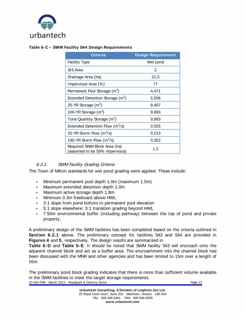
Table 6-C – SWM Facility S44 Design Requirements
Criteria Design Requirement
Facility Type Wet pond
SIS Area 2
Drainage Area (ha) 21.5
Impervious Area (%) 77
Permanent Pool Storage (m3) 4,471
Extended Detention Storage (m3) 5,506
25-YR Storage (m3) 8,407
100-YR Storage (m3) 9,893
Total Quantity Storage (m3) 9,893
Extended Detention Flow (m3/s) 0.025
25-YR Storm Flow (m3/s) 0.213
100-YR Storm Flow (m3/s) 0.352 Required SWM Block Area (ha) (assumed to be 50% impervious) 1.2
6.2.1. SWM Facility Grading Criteria The Town of Milton standards for wet pond grading were applied. These include:
Minimum permanent pool depth 1.0m (maximum 1.5m) Maximum extended detention depth 1.0m Maximum active storage depth 1.8m Minimum 0.3m freeboard above HWL 3:1 slope from pond bottom to permanent pool elevation 5:1 slope elsewhere; 3:1 transition grading beyond HWL 7.50m environmental buffer (including pathway) between the top of pond and private
property. A preliminary design of the SWM facilities has been completed based on the criteria outlined in Section 6.2.1 above. The preliminary concept for facilities S43 and S44 are provided in Figures 4 and 5, respectively. The design results are summarized in Table 6-D and Table 6-E. It should be noted that SWM facility S43 will encroach onto the adjacent channel block and act as a buffer area. The encroachment into the channel block has been discussed with the MNR and other agencies and has been limited to 15m over a length of 55m. The preliminary pond block grading indicates that there is more than sufficient volume available in the SWM facilities to meet the target storage requirements.

10-334-FSR - March 2013 - Royalpark & Century Grove Page 14
Urbantech Consulting, A Division of Leighton-Zec Ltd. 25 Royal Crest Court, Suite 201 Markham, Ontario L3R 9X4
TEL: 905.946.9461 FAX: 905.946.9595 www.urbantech.com
Table 6-D – Preliminary Facility S43 Design
Criteria Elevation Range
Required [m3]
Provided [m3]
Permanent Pool 210.00-211.30 5,741 6,777
Extended Detention 211.30-212.30 6,794 8,428
25 Yr 212.30-212.50 10,374 10,492
100 Yr 212.50-212.70 12,207 12,646
Table 6-E – Preliminary Facility S44 Design
Criteria Elevation Range
Required [m3]
Provided [m3]
Permanent Pool 207.00-208.40 4,471 6,671
Extended Detention 208.40-209.40 5,506 6,829 25 Yr 209.40-209.90 8,407 11,036 100 Yr 209.90-210.20 9,893 13,778
6.3. Facility Components
6.3.1. Sediment Forebay The proposed SWM facilities incorporate a sediment forebay for each inlet to enhance pollutant removal by capturing the heavier sediments near the inlet, dissipating the inflow velocity, and providing an easily accessible area for frequent maintenance activities. The forebay will be designed with a length to width ratio of approximately 3:1 where possible and will not exceed 30% of the permanent pool surface area, as required in the SWMP Design Manual. Additional berming or alternate berming configurations within the forebay of Pond S44 may be required to achieve the 3:1 length to width ratio. This will be explored at detailed design. The forebay will be designed with a minimum depth of 1.2m to minimize the potential for re-suspension.
6.3.2. Maintenance Access Road A 5.0m access road has been provided to facilitate maintenance activities around the inlet and outlet structures, as well as the sediment forebay. Typical standards require a maintenance road around the entire perimeter of the facility. In most cases, the overall length and cost of the access roads required for sediment removal and inlet/outlet maintenance can be reduced by approx 50% by only providing access roads to the inlet, outlet and ramps to pond forebay and
10-334-FSR - March 2013 - Royalpark & Century Grove Page 15
Urbantech Consulting, A Division of Leighton-Zec Ltd. 25 Royal Crest Court, Suite 201 Markham, Ontario L3R 9X4
TEL: 905.946.9461 FAX: 905.946.9595 www.urbantech.com
main cell. Therefore, the proposed consolidated facilities are provided with maintenance access only where required, not around the entire perimeter.
6.3.3. SWM Facility Outfall At detailed design, the facility outlet structures will be designed such that the actual discharge from the SWM facilities is controlled to the target flows noted in the preceding sections. Flow control will be achieved by a reverse slope pipe with orifice control plate (for the extended detention flows) and one or more orifice / weirs (for the 2-year to 100-year events). Facility S43 is proposed to outlet directly to tributary NW-2-G1 in conformance with the SIS. This facility will be adjacent to the realigned channel. Although facility S44 is close to the realigned NW-2-G1 tributary, it will discharge to Sixteen Mile Creek (NW-1-A) as its contributing drainage area naturally drains in this direction. Since the facility is relatively far from Sixteen Mile Creek, a long, piped outlet will be required through a Town easement between two proposed lots. This outlet pipe will discharge to a cooling trench / swale, which must be cut into the existing channel bank. A spillway for facility S43 is proposed; this spillway will direct Regional flow (or 100-year uncontrolled from, if greater) from the pond into the adjacent channel. Facility S44 will not release emergency flows to the adjacent watercourse NW-2-G1. All discharge, including Regional / emergency flow will be directed to Sixteen Mile Creek in order to respect watershed boundaries. Therefore, the emergency spillway for this facility will be a high-capacity inlet grate on the outlet control structure, which will operate in the event that the 100-year outlet control structure openings are obstructed. Outfall cross sections for Facilities S43 and S44 are indicated on Figures 4 and 5, respectively.
6.3.4. Thermal Mitigation Regarding thermal mitigation, the recommendations from the SIS will be further considered at the detailed design level as the majority of mitigation measures relate to landscaping and detailed lot-level and pond design. The Draft CVC “Thermal Impacts of Urbanization including Preventative and Mitigation Techniques” report was reviewed to develop a “long list” of potential thermal mitigation measures. The report identified 5 “zones” where thermal mitigation measures can be implemented. These include:
Zone 1 – Up-gradient (i.e. pond catchment area) Zone 2 – SWM facility inlet Zone 3 – SWM facility

10-334-FSR - March 2013 - Royalpark & Century Grove Page 16
Urbantech Consulting, A Division of Leighton-Zec Ltd. 25 Royal Crest Court, Suite 201 Markham, Ontario L3R 9X4
TEL: 905.946.9461 FAX: 905.946.9595 www.urbantech.com
Zone 4 – SWM facility outlet Zone 5 – Riparian corridor
The following table indicates a number of mitigation measures reviewed and which measures are potentially feasible for implementation at the detailed design stage for each SWM Pond in the Milton Heights development. If a measure is not applicable, rationale for this recommendation is provided in the notes below. Further analysis at the detailed design level may exclude or include additional mitigation measures. Table 6-F – Thermal Mitigation Alternatives
Thermal Mitigation Alternatives SWM FACILITY Zone S43 S44
Energy transfer between warm storm runoff and cool subsurface storm sewers Zone 1
LID measures Zone 1 TBD1 TBD1 Roof Colour Zone 1 TBD1 TBD1 Downspout Disconnection (where RDCs are not required) Zone 1
Up-gradient Plantings Zone 1
Buried Inlet Pipe Zone 2
Inlet Cooling trench Zone 2 X2 X2 Inlet plantings Zone 2
Shading of open water areas by maximizing canopy Zone 3
Artificial shade systems / Floating Island Zone 3 X3 X3 Reduce open water area Zone 3
Increased L:W ratio Zone 3
Pond orientation to reduce solar inputs Zone 3
Pond orientation to increase exposure to prevailing wind Zone 3
Landscaped jetties for shading Zone 3 X2 X2
Subsurface SWM ponds Zone 3 X4 X4
Outlet subsurface cooling trench and shading Zone 4
Concrete outlet pipe Zone 4
Introduce cool water at SWM pond outlets such as foundation drain collectors (FDC) where feasible Zone 4

10-334-FSR - March 2013 - Royalpark & Century Grove Page 17
Urbantech Consulting, A Division of Leighton-Zec Ltd. 25 Royal Crest Court, Suite 201 Markham, Ontario L3R 9X4
TEL: 905.946.9461 FAX: 905.946.9595 www.urbantech.com
Thermal Mitigation Alternatives SWM FACILITY Zone S43 S44
Reversed slope submerged pond outlet and extra permanent pool depth at outlet Zone 4
Distributed outlets along the NHS to take advantage of the NHS shading Zone 4
Night time release Zone 4 X5 X5
Watercourse Shading Zone 5
Notes: 1 – To be determined at functional servicing / detailed design phase if applicable based on detailed soil investigation and restrictions related to private and public property use. 2 - Not recommended due to grading, capacity, or maintenance constraints 3 - The CVC is proposing a floating island in Pond 10 in Fletcher’s Meadow (Brampton) and the monitoring/maintenance results of that pilot project will help determine its effectiveness. The use of floating islands and other shade structures depends on performance and general design feasibility. Shade structures are typically difficult to implement in large facilities and create additional maintenance requirements. 4 - Subsurface storage is typically not suitable for large drainage areas since costs become prohibitive. There may be application of sub-surface storage in commercial areas, to be determined through detailed design. 5 - Night-time release requires complex control systems that would have to be maintained by the Town. These measures are therefore not recommended at this time.
Discussions with MNR staff in other municipalities have led to the conclusion that cooling trenches and/or deeper permanent pools should be provided for every facility. The requirement for deeper permanent pools (average depth of 3m) is currently being reviewed since this currently is not consistent with typical design standards. With respect to cooling trenches, it is generally preferable that they be located outside the meander belt. The preferred thermal mitigation strategy will be further refined during the detailed natural channel / NHS design and detailed SWM facility design stage. Planting/landscaping details for the various ponds will be addressed in detail at the detailed design stage.

10-334-FSR - March 2013 - Royalpark & Century Grove Page 18
Urbantech Consulting, A Division of Leighton-Zec Ltd. 25 Royal Crest Court, Suite 201 Markham, Ontario L3R 9X4
TEL: 905.946.9461 FAX: 905.946.9595 www.urbantech.com
6.4. Operations and Maintenance
Detailed operations and maintenance guidelines will be submitted for the SWM facilities at the detailed design stage. The guidelines will be prepared in conformance with the Town of Milton standards, the Subwatershed Study, and the SWMP Design Manual.

10-334-FSR - March 2013 - Royalpark & Century Grove Page 19
Urbantech Consulting, A Division of Leighton-Zec Ltd. 25 Royal Crest Court, Suite 201 Markham, Ontario L3R 9X4
TEL: 905.946.9461 FAX: 905.946.9595 www.urbantech.com
7. CHANNEL NW-2-G1 REALIGNMENT & NATURAL HERITAGE SYSTEM
7.1. Natural Channel Design Criteria
The development of the Sherwood Survey Secondary Plan lands provides an opportunity to naturalize channel form and function, to create aquatic and terrestrial habitat, and to enhance hydraulic conditions of the channel. Through the increase in imperviousness within the tributary drainage areas and the extended detention stormwater management practices implemented with the development, the total base flow will be augmented, which will result in improved aquatic habitat. Further, the lowering of the channel through the designated channel corridor will, in the area between Highway 401 and New Tremaine Road, result in groundwater contributions to the watercourse that will provide a further benefit to aquatic habitat. In order to sustain a functional channel, a fluvial geomorphologic analysis was conducted to identify key channel design parameters and objectives, which include:
Promote fish and amphibian habitat through the creation of wetland features in the floodplain and in-stream features.
Enable floodplain access for larger than the 2 year flows (i.e., channel dimensions designed to contain the 2-yr flow channel capacity).
Enable groundwater discharge into the channel upstream of New Tremaine Road, where hydrogeologic conditions allow.
Maintain or increase floodplain storage by the creation of wetland features in the landscape.
Accommodate the anticipated flows from the original watercourse, the Highway 401 roadside drainage, and the proposed stormwater pond towards the existing No. 3 Side Road within the proposed channel design.
Create diversity in channel morphology with the aim of developing aquatic habitat features that are beneficial to Red Side Dace fish species. This will include a meandering channel with riffle/pool sequences that will not only provide habitat but also create hydraulic diversity
Maximize channel length upstream of New Tremaine Road to reduce overall channel grade so that erosive potentials are reduced and channel stability is promoted.
Promote a stable morphology and minimize sediment accumulation within the channel from existing No. 3 Side Road to Peru Road. Due to grade controls, this will require a less sinuous planform. Ensure that the width of the channel corridor bottom is sufficiently wide so that the floodplain area that the watercourse may be expected to occupy both now and in the future (i.e., referred to as the ‘meander belt’) is protected.
Consider erodibility of the native material that will be exposed due to channel corridor lowering within the channel design so that it does not promote excessive erosion or deposition.

10-334-FSR - March 2013 - Royalpark & Century Grove Page 20
Urbantech Consulting, A Division of Leighton-Zec Ltd. 25 Royal Crest Court, Suite 201 Markham, Ontario L3R 9X4
TEL: 905.946.9461 FAX: 905.946.9595 www.urbantech.com
Create a dynamically stable channel.
This natural channel design and analysis for the NW-2-G1 watercourse was performed by Aquafor Beech and is described in detail in the channel design brief. The proposed west to east reach of the channel along Highway 401 varies in width, but is on average 75 m wide and approximately 650 m long. The north to south reach along the existing Peru Road alignment is 75 m wide and approximately 575 m long. Table 7-A summarizes the relevant features incorporated in the channel. Table 7-A – Natural Channel Design Parameters
Parameter NW-2-G1 (west-east)
NW-2-G1 (north-south)
Channel Slope % 0.37 0.12
Low flow depth [m] 0.40 to 0.70 0.45 to 0.75
Low flow top width [m] 2.90 to 3.20 3.30 to 3.70
Meander belt slope % 0.57 0.19 Available Meander belt width [m] 41.0 to 81.7 37 to 60
Depth from toe to TOB [m] 2.5 to 3.5 1.25 to 2.0
Transition Grading slope - 2:1 – 10:1 2.5:1 - 4:1
Channel Top width [m] ~ 60 (varies) ~ 60 (varies)
Environmental buffer [m] 7.50 per side 7.50 per side
Typical Channel width [m] 75 75
7.2. Channel hydraulics
The channel monitoring and hydrologic modeling work conducted by AMEC in the Subwatershed Update Study was used to establish the existing and post development flows for the watercourses in the subject lands. Preliminary hydraulic models for existing and proposed conditions were provided by RAND Engineering in the SIS. These models were updated to account for improved topographic survey data and proposed natural channel design.
7.2.1. Riparian Storage A hydraulic analysis was performed to evaluate the riparian storage for the existing and proposed realigned NW-2-G1 watercourse. The riparian storage is defined as the existing storage within the channel prior to the construction of any infrastructure, including culverts. A post-development versus pre-development comparison was made to indicate if sufficient storage is provided for all return period events within the proposed channels. The existing
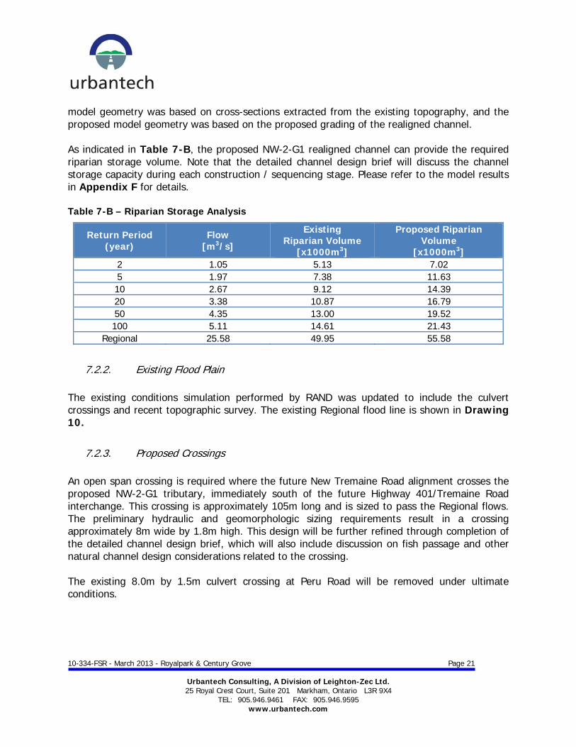
10-334-FSR - March 2013 - Royalpark & Century Grove Page 21
Urbantech Consulting, A Division of Leighton-Zec Ltd. 25 Royal Crest Court, Suite 201 Markham, Ontario L3R 9X4
TEL: 905.946.9461 FAX: 905.946.9595 www.urbantech.com
model geometry was based on cross-sections extracted from the existing topography, and the proposed model geometry was based on the proposed grading of the realigned channel. As indicated in Table 7-B, the proposed NW-2-G1 realigned channel can provide the required riparian storage volume. Note that the detailed channel design brief will discuss the channel storage capacity during each construction / sequencing stage. Please refer to the model results in Appendix F for details. Table 7-B – Riparian Storage Analysis
Return Period (year)
Flow [m3/s]
Existing Riparian Volume
[x1000m3]
Proposed Riparian Volume
[x1000m3] 2 1.05 5.13 7.02 5 1.97 7.38 11.63 10 2.67 9.12 14.39 20 3.38 10.87 16.79 50 4.35 13.00 19.52 100 5.11 14.61 21.43
Regional 25.58 49.95 55.58
7.2.2. Existing Flood Plain The existing conditions simulation performed by RAND was updated to include the culvert crossings and recent topographic survey. The existing Regional flood line is shown in Drawing 10.
7.2.3. Proposed Crossings An open span crossing is required where the future New Tremaine Road alignment crosses the proposed NW-2-G1 tributary, immediately south of the future Highway 401/Tremaine Road interchange. This crossing is approximately 105m long and is sized to pass the Regional flows. The preliminary hydraulic and geomorphologic sizing requirements result in a crossing approximately 8m wide by 1.8m high. This design will be further refined through completion of the detailed channel design brief, which will also include discussion on fish passage and other natural channel design considerations related to the crossing. The existing 8.0m by 1.5m culvert crossing at Peru Road will be removed under ultimate conditions.

10-334-FSR - March 2013 - Royalpark & Century Grove Page 22
Urbantech Consulting, A Division of Leighton-Zec Ltd. 25 Royal Crest Court, Suite 201 Markham, Ontario L3R 9X4
TEL: 905.946.9461 FAX: 905.946.9595 www.urbantech.com
7.2.4. Proposed Water Levels A hydraulic analysis was carried out for the ultimate NW-2-G1 channel. The results of the analysis demonstrated that flows up to the Regional event can be safely conveyed through the channel and no impact will occur upstream or downstream of the proposed development. A minimum 0.3m freeboard measured from the rear lot line will be provided along the channel at all locations. Please see Figure 11 for the proposed Regional floodline. Details on flows, water surface elevation and other hydraulic variables for the full range of return period events can be found in the channel design brief.
7.3. Construction Staging
The channel will be constructed in stages to facilitate the Town of Milton requirement to keep Peru Road open until the new road construction west of the proposed NW-2-G-1 channel in the 1321387 Ontario Inc. lands is operational. The channel staging will be designed such that sufficient riparian storage is always maintained within the active channel corridor and that the realigned channels sections can be stabilized prior to diverting flow into them. A detailed construction staging plan is provided in Figures STG 1 to STG 4.
7.4. Groundwater Management Plan
The Groundwater Management Plan, provided in Appendix B, identified a pre-construction monitoring to establish baseline groundwater and surface water conditions prior to the initiation of earthworks. Monitoring during construction to trigger any contingency actions required to prevent or mitigate impacts to the groundwater and surface water. A Post-construction monitoring plan to confirm acceptable groundwater and surface conditions once the new channel has been established. Due to the nature of the surficial sediments (till soils) significant dewatering is not anticipated to be required to complete the proposed channel construction, however minor groundwater seepage into the excavation can be expected.
7.4 Natural Heritage System
Based on detailed site investigations undertaken through preparation of the SIS for Areas 1 and 2, several modifications to the proposed NHS in Schedule C-8-D of the Sherwood Survey Secondary Plan (Town of Milton, 2004) are recommended. The NW-2-G1 watercourse is classified as “Greenlands A” in the Secondary Plan in support of the protected Redside dace habitat. However, this classification did not take into account the proposed New Tremaine Road/Highway 401 interchange works and required channel alignment. The re-aligned NW-2-G1 tributary will part of the revised NHS. Therefore, the NHS boundary through the proposed development will match the channel corridor, including buffers.

10-334-FSR - March 2013 - Royalpark & Century Grove Page 23
Urbantech Consulting, A Division of Leighton-Zec Ltd. 25 Royal Crest Court, Suite 201 Markham, Ontario L3R 9X4
TEL: 905.946.9461 FAX: 905.946.9595 www.urbantech.com
8. WASTEWATER SERVICING
The Milton Heights (North) plan of subdivision wastewater will be accommodated through the existing gravity wastewater main on Peru Road to Market Drive. This infrastructure provides the wastewater outlet for the proposed development. To accommodate the existing residences fronting Tremaine Road, the elevation of the sanitary sewer on 3rd Side Road will be low enough to allow the Region to continue providing service the existing residences on Tremaine in the future. Internal sanitary sewers will be constructed along the proposed streets and individual service connections will be provided for each unit within the development. Please refer to Figure 6 for preliminary sanitary concept. Sanitary sewer design sheets are included in Appendix D. The Region of Halton outlines their criteria for the design of wastewater systems in their “Design Criteria, Contract Specifications and Standard Drawings” manual. These criteria will be adhered to throughout the design and construction of the wastewater system. The following criteria apply:
Average per capita flow rate: 365L/c/d Peak flow factor – residential: PFR=1+14/(4+P0.5) Peak flow factor – commercial: PFC=0.8 x (1+14/(4+P0.5)) Infiltration/Inflow allowance: 0.286L/s/ha Residential High Density: 135p/ha Residential Low Density: 55p/ha Equivalent Population Commercial: 90p/ha Minimum sewer size (commercial): 300mm Minimum sewer size (residential): 200mm Minimum / maximum velocity: 0.6m/s to 3.0m/s

10-334-FSR - March 2013 - Royalpark & Century Grove Page 24
Urbantech Consulting, A Division of Leighton-Zec Ltd. 25 Royal Crest Court, Suite 201 Markham, Ontario L3R 9X4
TEL: 905.946.9461 FAX: 905.946.9595 www.urbantech.com
9. WATER DISTRIBUTION
The proposed development is located within the extension of the Region of Halton Zone ML-5 Lake-Based Water District. Genivar Inc. was retained to assess the water distribution system. Appendix E contains the results of their analysis. An existing 450mm transmission main (lake-based supply) located at Highway 401 east of the proposed development will provide the water supply for the site. The existing well-based 300mm supply through the north side of the site is redundant and is not required to service the subject lands according to discussions with Halton Region. A connection will be maintained at the stub remaining after removal of the 300mm pipe on the east side of the site, through the SWM facility S43 block. The proposed development will be serviced by a single feed connection (300mm) to the existing lake-based watermain at Highway 401. This connection is temporary and is only required until the 450mm Tremaine Road Feedermain on New Tremaine Road is installed and operational. Refer to Figure 7 for watermain locations and Appendix E for the analysis the water distribution system. As per typical road cross sections, the watermain is located on the same side as the sidewalk, on single loaded roads. Please refer to sidewalk location plan on Figure 9. Individual service connections will be provided to the lots within the development from the watermain on the fronting street.

10-334-FSR - March 2013 - Royalpark & Century Grove Page 25
Urbantech Consulting, A Division of Leighton-Zec Ltd. 25 Royal Crest Court, Suite 201 Markham, Ontario L3R 9X4
TEL: 905.946.9461 FAX: 905.946.9595 www.urbantech.com
10. SIDEWALK NETWORK
As per typical road cross sections, the sidewalk is generally located on the same side of the right of way from the watermain. A sidewalk layout is included as part of this submission (refer to Figure 8) which illustrates how the proposed sidewalk layout will provide a link to the various blocks within the proposed subdivision.

10-334-FSR - March 2013 - Royalpark & Century Grove Page 26
Urbantech Consulting, A Division of Leighton-Zec Ltd. 25 Royal Crest Court, Suite 201 Markham, Ontario L3R 9X4
TEL: 905.946.9461 FAX: 905.946.9595 www.urbantech.com
11. PROPOSED ROAD CROSS SECTIONS AND LANEWAYS
There are several ROW types within the proposed development.
11.1. Laneways (11m ROW)
The use of laneways eliminates front yard driveways which allows for more room within the standardized boulevards for aboveground utilities and street trees on both sides of the road. The 11.0m laneways within the proposed development promotes townhouses with rear laneway garages. This type of development allows for a greater population density and allows continued utilization of the standard road boulevards for utilities and street landscape as the design eliminates driveways at the frontage of the houses. The proposed laneway was derived from the Town of Milton standard Drawing No. E-10 (11m Road Allowance – Laneway). Double loaded laneway products can require additional consideration when dealing with snow removal. There are several options available for snow removal within a laneway product including salting, plowing, snow removal (loading the snow into trucks and hauling to a snow dump site). For the double loaded laneways, it is proposed that during snow storm events that cannot be resolved by salting alone, that the snow from the laneways be pushed into the connecting right-of-ways and then plowed onto the boulevard as part of the regular municipal snow plowing operations. There may be additional boulevard storage adjacent to irregular lots at the ends of each townhouse block.
11.2. Local Roads (16m ROW)
The Town of Milton standard 16m ROW is proposed for local roads within the proposed subdivision. The ROW dimensions are based on Town of Milton standard Drawing No. E-2.
11.3. 3rd Side Road (20m ROW)
3rd Side Road is the main east/west collector road through the proposed development. The existing 3rd Side Road will be urbanized as per Figure 9 and will have a modified 20m ROW section (similar to Town of Milton standard Drawing No. E-3). On-street parking will be provided, and the minimum number of lanes widths is recommended as a calming feature to prevent speeding (refer to the HDR | iTRANS technical memo included in Appendix G).
11.4. Private/Condo Laneways (7.5m ROW)
The proposed condo blocks will have 7.5m internal ROWs. Storm sewers may be required within the 7.5m ROW to manage surface drainage, but all other services (sanitary, water) and utilities can be provided to these units from the municipal ROW.
11.5. New Tremaine Road / Interchange
The New Tremaine Road alignment and Highway 401 interchange will be designed by others.

10-334-FSR - March 2013 - Royalpark & Century Grove Page 27
Urbantech Consulting, A Division of Leighton-Zec Ltd. 25 Royal Crest Court, Suite 201 Markham, Ontario L3R 9X4
TEL: 905.946.9461 FAX: 905.946.9595 www.urbantech.com
12. PHASING
The proposed development will be developed in multiple phases. Phasing details and discussion on alternate phasing strategies will be revisited at the detailed design phase. In the interim, refer to Figure 12 for the location of the preliminary development phases for the Royalpark North plan. In order to service Phase 1 of Royalpark North, the following items must be in place:
Pond S43, to provide SWM controls Realignment of the NW-2G-1 corridor to provide outfall for pond Extension of the Market Drive sanitary sewer Storm, sanitary, and water services on 3rd Side Road (while maintaining existing services
on 3rd Side Road for existing properties Lake-based supply watermain crossing of NW-2-G1 (crossing can be pre-installed during
channel construction) The requirements for servicing of the other Phases and the Century Grove lands will be included in the detailed design submissions. As discussed in Section 8 and Section 9, the proposed development will be serviced by new sanitary and water main infrastructure located on Peru Road (north of Market Drive). The Town of Milton staff recommended that a road condition assessment be undertaken prior to installation of these services. It should be noted, however, that Peru Road will be closed and limited to local traffic only (i.e. it will no longer act as a “through” street). Furthermore, the road will be restored to original or better conditions following installation of the proposed services. At the time of detailed design, this issue will be revisited to determine if a road condition assessment is required.

10-334-FSR - March 2013 - Royalpark & Century Grove Page 28
Urbantech Consulting, A Division of Leighton-Zec Ltd. 25 Royal Crest Court, Suite 201 Markham, Ontario L3R 9X4
TEL: 905.946.9461 FAX: 905.946.9595 www.urbantech.com
13. EROSION AND SEDIMENT CONTROL DURING CONSTRUCTION
The erosion and sediment control plan for the site will be designed in conformance with the Town of Milton and Conservation Halton guidelines. Erosion and sediment control will be implemented for all construction activities including topsoil stripping, foundation excavation and stockpiling of materials. The following erosion and sediment control measures will be installed and maintained during construction: A temporary sediment control fence will be placed prior to grading. Use of the permanent facility as a temporary silt basin Sediment traps will be provided Gravel mud mats will be provided at construction vehicle access points to minimize off-
site tracking of sediments All temporary erosion and sediment control measures will be routinely inspected and
repaired during construction. Temporary controls will not be removed until the areas they serve are restored and stable.
A detailed channel staging and construction plan will be prepared to ensure sensitive habitat and features will be protected and diversion channels suitably stabilized prior to use. Please refer to the Channel Design Brief, submitted under separate cover. Erosion and Sediment control drawings will be completed as part of the detailed design.

10-334-FSR - March 2013 - Royalpark & Century Grove Page 29
Urbantech Consulting, A Division of Leighton-Zec Ltd. 25 Royal Crest Court, Suite 201 Markham, Ontario L3R 9X4
TEL: 905.946.9461 FAX: 905.946.9595 www.urbantech.com
14. CONCLUSIONS
This report has clearly demonstrated that: The proposed stormwater management facilities can meet the water quality, quantity
and erosion control requirements for the Milton Heights (North) Plan of subdivision, as per the SIS requirements and MOEE guidelines.
The proposed storm drainage system is compatible with the Subwatershed Impact Study
within the Sherwood Survey Secondary Plan and MOEE guidelines. The proposed development can be serviced on full municipal services in accordance with
the approved servicing strategies for the Sixteen Mile Creek, Sherwood Survey, Subwatershed Management Study.
Report Prepared by: Andrew Fata Senior Water Resources Designer
Jeff Ormonde, P. Eng. Associate, Design
10-334-FSR - March 2013 - Royalpark & Century Grove Page 30
Urbantech Consulting, A Division of Leighton-Zec Ltd. 25 Royal Crest Court, Suite 201 Markham, Ontario L3R 9X4
TEL: 905.946.9461 FAX: 905.946.9595 www.urbantech.com
Appendix A
Geotechnical Investigation

10-334-FSR - March 2013 - Royalpark & Century Grove Page 31
Urbantech Consulting, A Division of Leighton-Zec Ltd. 25 Royal Crest Court, Suite 201 Markham, Ontario L3R 9X4
TEL: 905.946.9461 FAX: 905.946.9595 www.urbantech.com
Appendix B
Groundwater Management Plan

10-334-FSR - March 2013 - Royalpark & Century Grove Page 32
Urbantech Consulting, A Division of Leighton-Zec Ltd. 25 Royal Crest Court, Suite 201 Markham, Ontario L3R 9X4
TEL: 905.946.9461 FAX: 905.946.9595 www.urbantech.com
Appendix C
Storm Sewer Design Sheets and SWM Calculations

10-334-FSR - March 2013 - Royalpark & Century Grove Page 33
Urbantech Consulting, A Division of Leighton-Zec Ltd. 25 Royal Crest Court, Suite 201 Markham, Ontario L3R 9X4
TEL: 905.946.9461 FAX: 905.946.9595 www.urbantech.com
Appendix D
Sanitary Sewer Design Sheets

10-334-FSR - March 2013 - Royalpark & Century Grove Page 34
Urbantech Consulting, A Division of Leighton-Zec Ltd. 25 Royal Crest Court, Suite 201 Markham, Ontario L3R 9X4
TEL: 905.946.9461 FAX: 905.946.9595 www.urbantech.com
Appendix E
Water Distribution System Analysis (GENIVAR)

10-334-FSR - March 2013 - Royalpark & Century Grove Page 35
Urbantech Consulting, A Division of Leighton-Zec Ltd. 25 Royal Crest Court, Suite 201 Markham, Ontario L3R 9X4
TEL: 905.946.9461 FAX: 905.946.9595 www.urbantech.com
Appendix F
HEC-RAS Model Results

10-334-FSR - March 2013 - Royalpark & Century Grove Page 36
Urbantech Consulting, A Division of Leighton-Zec Ltd. 25 Royal Crest Court, Suite 201 Markham, Ontario L3R 9X4
TEL: 905.946.9461 FAX: 905.946.9595 www.urbantech.com
Appendix G
3rd Side Road Technical Memo (HDR | iTRANS)

10-334-FSR - March 2013 - Royalpark & Century Grove Page 37
Urbantech Consulting, A Division of Leighton-Zec Ltd. 25 Royal Crest Court, Suite 201 Markham, Ontario L3R 9X4
TEL: 905.946.9461 FAX: 905.946.9595 www.urbantech.com
FIGURES
Figure 1 Site Location Figure 2 Grading Concept Figure 3.1 Pre-Development Drainage Plan Figure 3.2 Post-Development Drainage Plan Figure 3.3 Major Storm System Drainage Plan Figure 4 Stormwater Management Facility S43 Figure 5 Stormwater Management Facility S44 Figure 6 Sanitary Drainage Plan Figure 7 Watermain Concept Plan Figure 8 Sidewalk Location Plan Figure 9 3rd Side Road Cross Section Figure 10 Existing Regional Flood Mapping Figure 11 Proposed Regional Flood Mapping Figure STG-1 NW-2-G1 Construction Staging Plan (Stage 1) Figure STG-2 NW-2-G1 Construction Staging Plan (Stage 2) Figure STG-3 NW-2-G1 Construction Staging Plan (Stage 3) Figure STG-1 NW-2-G1 Construction Staging Plan (Stage 4)