Embed Size (px)
Citation preview

Functional Servicing Report Residential Development 600 Myers Road City of Cambridge June 2017
1315 Bishop Street North, Suite 202
Cambridge, ON N1R 6Z2
t 519.623.1140 f 519.623.7334
www.meritech.ca
Project No.: 3304


Functional Servicing Report
K:\Projects\3304\60-Design\3304.Functional Servicing.rpt.docx June 2017 Page i
Executive Summary The proposed development is for semi-detached and townhouse dwellings fronting Lisbon Pines Drive. The subject property is 0.89 hectares in size and is located in the northwest corner of Myers Road and Lisbon Pines Drive in Cambridge, Ontario. The property is bordered by existing residential land. The existing sanitary sewers on Lisbon Pines Drive are approximately 8 metres below the centerline road elevation. To provide residential services to the proposed development at a standard depth, a local sewer system is proposed. The local sewer will connect to the existing 250mm sanitary sewer mainline on Lisbon Pines via external drop structures. The existing watermain on Lisbon Pines Drive is a 200mm diameter PVC main. Fire hydrants are located at the north-east corner of Myers Road and Lisbon Pines Drive as well as between Slater Street and Myers Road, directly across from the property. Individual residential services will be provided for the proposed development. Both FUS and OBC fire fighting flows can be met by the existing distribution system on Lisbon Pines Drive. Pre-submission comments from a meeting on March 30, 2017 as well as a meeting with City of Cambridge Engineering staff on June 9, 2017 confirm that stormwater management (quality and quantity control) is not required for this site. Energy+, Union Gas, Rogers, and Bell Canada have services in the vicinity. Services are immediately adjacent to the property off of both Myers Road and Lisbon Pines Drive and can be extended to service the proposed development. This will be coordinated at the detailed design stage. Approval agencies should review and approve this document as a suitable approach to a preliminary design configuration and Draft Plan approval. Comments from this servicing approach shall be incorporated into the detailed design.
Functional Servicing Report
K:\Projects\3304\60-Design\3304.Functional Servicing.rpt.docx June 2017 Page ii
Use and Reproduction of This Document No part of this report may be reproduced, stored in a retrieval system, or transcribed in any form, or by means including electronic, mechanical, photocopying, recording and scanning without the prior written approval of the author.
For Further Information For further information regarding this report please contact the author at the following address:
Meritech Engineering Attention: Mr. Ian S. Robertson, P.Eng. Director of Engineering 1315 Bishop Street North, Suite 202 Cambridge, ON N1R 6Z2 t (519) 623-1140 f (519) 623-7334 email: [email protected]

Functional Servicing Report
K: \Pro j ec ts \3304\60-Des ign\3304 .Func t i ona l Se rv ic ing . rp t .docx Page 1
Table of Contents Introduction ................................................................................................................. 3
Approach ..................................................................................................................... 4
Policy Framework ......................................................................................................... 5
MOE Guidelines ......................................................................................................... 5
Regional Guidelines ................................................................................................... 5
Municipal Guidelines .................................................................................................. 5
Conservation Authority Guidelines ............................................................................... 5
Geotechnical Studies .................................................................................................. 5
Pre-Consultation/Design Criteria ................................................................................. 6
Reconnaissance ......................................................................................................... 6
Objectives and Criteria .................................................................................................. 7
Sanitary Servicing ...................................................................................................... 7
Water Servicing ......................................................................................................... 7
Storm Servicing ......................................................................................................... 7
Stormwater Management ........................................................................................... 7
Grading and Drainage ................................................................................................ 7
Utilities ..................................................................................................................... 8
Discussion .................................................................................................................... 8
Subdivision Design .................................................................................................... 8
Sanitary Servicing ...................................................................................................... 8
Water Servicing ......................................................................................................... 9
Existing Infrastructure ............................................................................................ 9
Proposed Development ........................................................................................... 9
Building Construction .............................................................................................10
Storm Servicing ........................................................................................................10
Stormwater Management ..........................................................................................10
Grading and Drainage ...............................................................................................10
Utilities ....................................................................................................................11
Construction Phasing / Approach ...............................................................................11
Conclusions .................................................................................................................12
Recommendations .......................................................................................................12
References ..................................................................................................................13
List of Figures Figure 1: Site Location .................................................................................................. 3
Figure 2: Approach Flowchart ........................................................................................ 4
Figure 3: Existing Conditions Photographs ...................................................................... 6
List of Tables Table 1: Average Daily Flows ......................................................................................... 8
Table 2: Domestic Water Demands ................................................................................ 9
Table 3: OBS and FUS Fire Fighting Flows ......................................................................10

Functional Servicing Report
K: \Pro j ec ts \3304\60-Des ign\3304 .Func t i ona l Se rv ic ing . rp t .docx Page 2
Appendices Appendix A: Draft Plan
Appendix B: Design Drawings
Appendix C: Design Sheets
Appendix D: Water Demand Calculations
Appendix E: Pre-Submission Comments
Appendix F: Geotechnical Report
Functional Servicing Report
K: \Pro j ec ts \3304\60-Des ign\3304 .Func t i ona l Se rv ic ing . rp t .docx Page 3
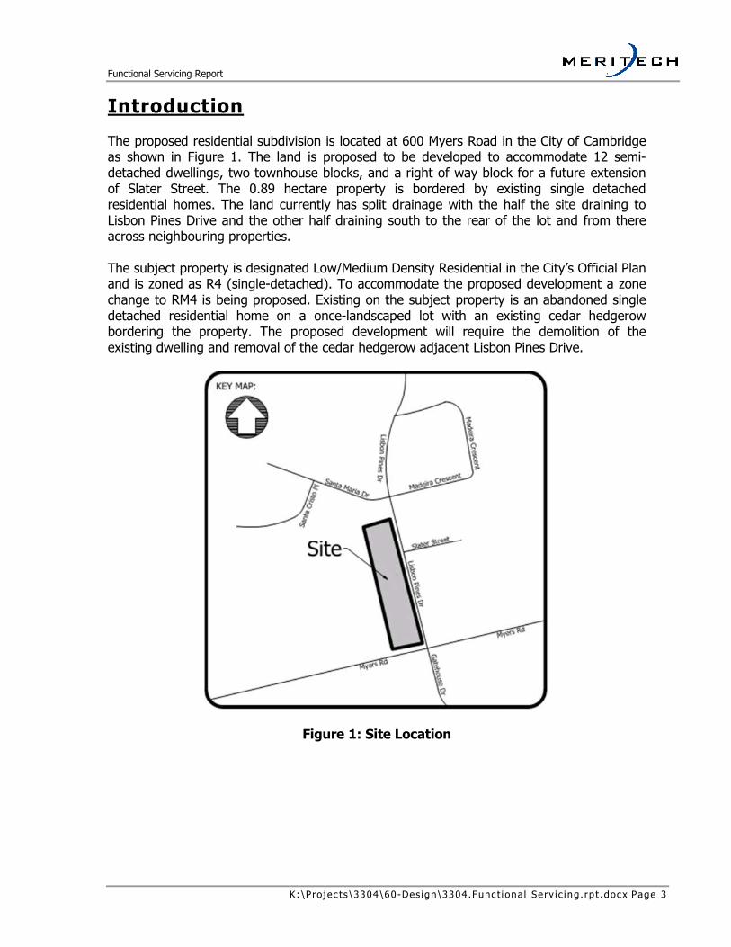
Introduction The proposed residential subdivision is located at 600 Myers Road in the City of Cambridge as shown in Figure 1. The land is proposed to be developed to accommodate 12 semi-detached dwellings, two townhouse blocks, and a right of way block for a future extension of Slater Street. The 0.89 hectare property is bordered by existing single detached residential homes. The land currently has split drainage with the half the site draining to Lisbon Pines Drive and the other half draining south to the rear of the lot and from there across neighbouring properties. The subject property is designated Low/Medium Density Residential in the City’s Official Plan and is zoned as R4 (single-detached). To accommodate the proposed development a zone change to RM4 is being proposed. Existing on the subject property is an abandoned single detached residential home on a once-landscaped lot with an existing cedar hedgerow bordering the property. The proposed development will require the demolition of the existing dwelling and removal of the cedar hedgerow adjacent Lisbon Pines Drive.
Figure 1: Site Location

Functional Servicing Report
K: \Pro j ec ts \3304\60-Des ign\3304 .Func t i ona l Se rv ic ing . rp t .docx Page 4
Step Three Detailed Design, or Final Design
This circulation integrates the recommendations of the preliminary design into the final site engineering. Approval of this report allows for construction of the proposed development.
Approach The City of Cambridge detailed the Engineering requirements in support of a Draft Plan application in a Pre-Consultation Comments dated March 30, 2017. These requirements include a Functional Servicing (this document) containing:
• The proposed Draft Plan – attached in Appendix A • Original Conditions Plan – included in Appendix B • Preliminary Servicing and Grading Plans – included in Appendix B • Sanitary and Storm Design Streets – included in Appendix C • Water Demand and Fire Fighting Flows – included in Appendix D • The Pre-Consultation Comments – attached in Appendix E • Geotechnical Report – excerpts attached in Appendix F
The flowchart below outlines the approval stages for this development. Due to the small size of the development, existing street frontage, and no environmental considerations Steps One and Two are being completed simultaneously.
Figure 2: Approach Flowchart
Step One Feasibility of the Development
This circulation establishes the framework for the project and provides a direction for how the site is to develop. This report shows the proposed development is suitable for
the proposed zoning and is able to be serviced with standard municipal services.
Step Two Preliminary Design
This circulation describes how the plan satisfies the objectives for the site, confirms spatial relationships of the plan within the confines of the site, and provides recommendations to be implemented in the detailed design. Draft Plan approval is contingent upon approval of the Preliminary Design.

Functional Servicing Report
K: \Pro j ec ts \3304\60-Des ign\3304 .Func t i ona l Se rv ic ing . rp t .docx Page 5
Policy Framework This chapter outlines the framework upon which the plan is built upon. Previous studies, municipal and provincial standards, as well as any field investigations undertaken to support the project, are examples of information described in this chapter. This background information is then used to build an appropriate plan for the site. The next chapter, Objectives and Targets, describes the site-specific requirements noted from the following sources:
MOE Guidelines Stormwater Management Planning and Design Manual, Ministry of the Environment, 2003 This manual provides guidelines on the planning and design of stormwater management facilities in Ontario.
Regional Guidelines Region of Waterloo and Area Municipalities Design Guidelines and Supplemental Specifications for Municipal Services Guidelines (DGSSMS) The design portion of this annually-updated document (Part B) should be considered as guidelines that provides the municipalities’ design preferences under normal circumstances. These guidelines are read together with Municipal guidelines and standards in place.
Municipal Guidelines City of Cambridge Engineering Standards & Development Manual This manual provides design guidelines for servicing and grading of subdivisions. It also includes a list of coefficients to be used in modelling of synthetic design storms.
Conservation Authority Guidelines Greater Golden Horseshoe Area Conservation Authority Erosion & Siltation Control Guideline for Urban Construction, December 2006 This document describes the methodology for determining the erosion potential of a site and the measures that should be undertaken to mitigate construction disturbance.
Geotechnical Studies A geotechnical report for the subject property is dated May 17, 2017 and was by CMT Engineering. The report indicates that the local groundwater table was not observed in the drilled bore holes at depths ±4.5m below existing grade. Soil conditions on the site range from fine-grained silt and sand to silty sand till soils which are not ideal for stormwater infiltration. Refer to Appendix F for excerpts of the Geotechnical Report.

Functional Servicing Report
K: \Pro j ec ts \3304\60-Des ign\3304 .Func t i ona l Se rv ic ing . rp t .docx Page 6
Pre-Consultation/Design Criteria Pre-Submission Comments from the City of Cambridge dated March 30, 2017 have been included in Appendix D. Key items from these comments are included in the following chapter ‘Objectives and Criteria’.
Reconnaissance A walk of the property was conducted on May 8, 2017 as part of our base plan work. The existing single detached dwelling on the property has be vacated and boarded up. Existing trees on the lot have largely been removed, with the notable exception of perimeter cedar hedges. Figure 3 shows existing conditions.
The existing dwelling fronting Myers Road Looking northwest from Myers Road
Looking south from the rear of the property Looking north along Lisbon Pines Drive
Figure 3: Existing Conditions Photographs

Functional Servicing Report
K: \Pro j ec ts \3304\60-Des ign\3304 .Func t i ona l Se rv ic ing . rp t .docx Page 7
Objectives and Criteria This section outlines the objectives and criteria for the wide variety of issues considered in this report; the following Discussion section will demonstrate how the objectives presented have been achieved and how the criteria are met.
Sanitary Servicing The primary objective with respect to sanitary servicing is that a sanitary sewer system servicing the site can be constructed as per MOE, Region of Waterloo (SSMS), and City of Cambridge standards. The development will outlet via gravity into a local sewer system prior to connections to the existing infrastructure on Lisbon Pines Drive through the use of a external drop structures. Sanitary capacity in the existing 250mm sanitary sewer on Lisbon Pines Drive is assumed to have sufficient capacity to support the proposed development.
Water Servicing There are two objectives regarding water servicing: provide domestic water supply as per Provincial, Regional, and City requirements, and ensure that an adequate firefighting water supply is available as per Ontario Building Code and other Regional requirements. The Region of Waterloo has provided pressure information for junction JCT_17644 located at the intersection of Lisbon Pines Drive and Slater Street. This information will be used to show that the existing water distribution system is able to provide fire protection as per OBC and FUS guidelines, as will be described in the following chapter.
Storm Servicing The primary objective with respect to storm servicing is that a storm sewer system servicing the site can be constructed as per MOE, Region of Waterloo (SSMS), and City of Cambridge standards. The development will outlet to existing storm sewer infrastructure, which are assumed to have capacity for this development.
Stormwater Management Pre-submission comments from a meeting on March 30, 2017 as well as a meeting with City of Cambridge Engineering staff on June 9, 2017 confirm that stormwater management (quality and quantity control) is not required for this site.
Grading and Drainage The primary grading and drainage objective for the site are to ensure that sanitary sewer services by gravity are provided, and that the lots drain to a suitable storm sewer outlet. As discussed in a meeting with City of Cambridge Engineering staff on June 9, 2017, the proposed design is centred around ensuring that overland flows from the rear of the lots in

Functional Servicing Report
K: \Pro j ec ts \3304\60-Des ign\3304 .Func t i ona l Se rv ic ing . rp t .docx Page 8
the major storm event are directed towards a right of way (i.e. Myers Road, Slater Street) and not to neighbouring properties to the west.
Utilities The following utility companies are required to confirm their ability to service the development:
• Energy+ • Bell Canada • Rogers Cable • Union Gas
Discussion
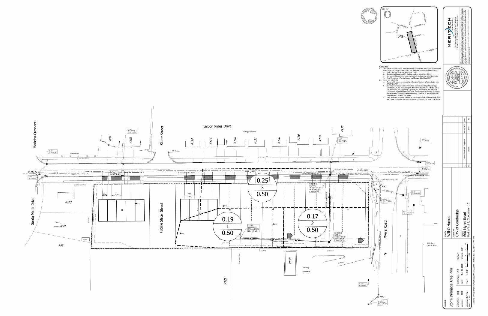
Subdivision Design The existing 0.89 hectare lot is proposed to be subdivided to accommodate 12 semi-detached units, two townhouse blocks (totaling 9 units), and an 18.5 metre wide right of way for the future extension of Slater Street. City of Cambridge Standard Drawing C106 details the typical cross section of the future Slater Street. It is noted that Lisbon Pine Drive now will have a 20.3 metre wide right of way along the proposed development due to the addition of a 0.3 metre wide reserve along the subdivision’s frontage to the road right of way. All of the proposed units are proposed to have individual sanitary, storm, and water services connecting to existing infrastructure. A local sanitary sewer is proposed to collect sewerage from the proposed development prior to discharge in to the existing 8 metre deep sanitary sewer on Lisbon Pines Drive. A 6 metre wide easement is proposed between lots 1 and 2, and another easement is proposed along the rear yards of the semi-detached units, both to accommodate storm drainage and a storm sewer connection conveying stormwater from the rear yard catchbasins to the existing 750mm storm sewer on Lisbon Pines Drive.
Sanitary Servicing Peak flows were calculated as shown in Table 1 to show the increased sanitary demand based on the proposed zone change for the site.
Zoning Density (pph)
Area (ha)
Population Peak Factor
Design Flow (L/s)
Existing R4 72 0.89 65 4.29 0.888
Proposed RM4 197 0.89 176 4.168 2.335
Table 1: Average Daily Flows

Functional Servicing Report
K: \Pro j ec ts \3304\60-Des ign\3304 .Func t i ona l Se rv ic ing . rp t .docx Page 9
The proposed development of 9 townhouse units and 12 semi-detached units will generate peak flows of approximately 2.3L/s. This peak flow rate is about 6% of the capacity of the 250mm diameter sewer on Lisbon Pines Drive. Under the R4 zoning flows from the lands were 2.5% of the capacity of the existing sewer. The existing sanitary sewers on Lisbon Pines Drive are approximately 8 metres below the centerline road elevation. Rather can create deep excavations for the proposed residential sanitary sewer connections, a proposed local sewer system will collect the sanitary sewerage. The local sewer system will connect to the existing 250mm sanitary sewer mainline on Lisbon Pines with external drop structures. An MOECC ECA will be required for the proposed local sewer system and will be submitted together with a future submission.
Water Servicing
Existing Infrastructure The existing watermain on Lisbon Pines Drive is a 200mm diameter PVC main. Fire hydrants are located at the northeast corner of Myers Road and Lisbon Pines Drive as well as between Slater Street and Myers Road, directly across from the property. The Region of Waterloo has provided pressure information for the watermain junction located on Lisbon Pines Drive and Slater Street detailing a design flow of 321.3 L/s.
Proposed Development The proposed residential development will connect individual services to the existing 200mm watermain on Lisbon Pines Drive. Water demands for the proposed development were calculated for domestic use and both FUS and OBC fire fighting flows as detailed in Appendix D. Domestic water demands for the proposed residential development are shown in Table 2.
Number of Units
Pop/ Density (ppl/unit)
Population Demand (l/c/d)
Demand (l/s)
Semi-detached 12 3.25 39 225 0.102
Townhouse 9 2.44 22 225 0.057
Table 2: Domestic Water Demands
Firefighting water demands for FUS and OBC fire fighting flows for the worst-case semi-detached dwelling and the two proposed townhouse blocks are shown in Table 3.

Functional Servicing Report
K: \Pro j ec ts \3304\60-Des ign\3304 .Func t i ona l Se rv ic ing . rp t .docx Page 10
OBC (L/s) FUS (L/S)
Semi-detached 45 133
Block 7 75 116
Block 8 90 127
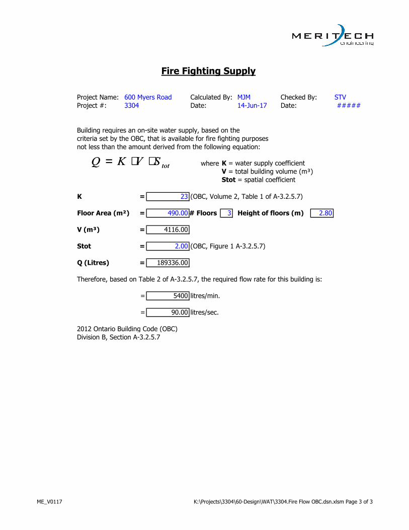
Table 3: OBS and FUS Fire Fighting Flows
Domestic water demands are insignificant to both the OBC and FUS fire fighting flows for the proposed development. The maximum fire fighting water demand of 133 L/s can be met by the existing water system on Lisbon Pines Drive to support the proposed development.
Building Construction The townhouse and semi-detached buildings will be constructed with standard wooden frames and will have concrete foundations. The buildings are not proposed to be sprinklered.
Storm Servicing Rear-yard catchbasins are proposed to convey runoff from the rear yards of both the semi-detached and townhouse units to the existing municipal storm sewer along Lisbon Pines Drive. Refer to the storm sewer design sheet in Appendix B. Overland flows from the rear yards – that is, flows in storm events greater than the 5-year event – are proposed to be conveyed in a grassed swale discharging to the Myers Road right of way. Storm runoff from the front lots of the proposed development will discharge uncontrolled to Lisbon Pines Drive.
Stormwater Management Pre-submission comments from a meeting on March 30, 2017 as well as a meeting with City of Cambridge Engineering staff on June 9, 2017 confirm that stormwater management (quality and quantity control) is not required for this site. Soil conditions on the site range from fine-grained silt and sand to silty sand till soils which are not ideal for stormwater infiltration.
Grading and Drainage The proposed development is to be fronting Lisbon Pines Drive and the overall lot grading for the site was developed in conjunction with City of Cambridge Standard Drawings C129 and C130. The lots are proposed to be split drainage in order to most closely match the existing topography for the site. The proposed side yard grading between the townhouse blocks will work with the future extension of Slater Street in the designated 18.5m right of way as per City of Cambridge Standard Drawing C105. As both sideyards are at 2.5%, the road extension will be as well;

Functional Servicing Report
K: \Pro j ec ts \3304\60-Des ign\3304 .Func t i ona l Se rv ic ing . rp t .docx Page 11
a low point will result between the existing curb on Lisbon Pines Drive and the proposed sidewalk. The right of way will be constructed as a grassed block for this development.
Utilities The following utility companies have responded with their ability to service the development:
• Energy + o The area is serviced by a combination of overhead and underground
conductors, no concerns were identified.
• Bell Canada o Bell has not responded at this time.
• Rogers Cable o There are existing cable lines along the property; no concerns were
identified. • Union Gas
o There is an existing line on Lisbon Pines Drive. Union Gas has not responded at this time.
Construction Phasing / Approach In order to provide sanitary, storm, and water services to the proposed development the section of Lisbon Pines Drive fronting the development is proposed to be closed to permit installation of services. The proposed road closure is to mimic a full road reconstruction road closure. Deep existing sanitary services and the existing watermain under the curb on the east side of the road warrant the complete road closure to allow for an efficient service installation. Some on-street parking could be accommodated on Santa Maria Drive and Madeira Crescent. Coordination with Grand River Transit (GRT) will be required as Lisbon Pines Drive is an existing bus route. We have contacted the Region of Waterloo’s project manager for the reconstruction of Myers Road, which is currently scheduled to be designed in 2018 and reconstructed in 2019. This timing appears to be somewhat dependent on other projects in the area. At this time, the Region has not selected a preferred ultimate cross-section for Myers Road.

Functional Servicing Report
K: \Pro j ec ts \3304\60-Des ign\3304 .Func t i ona l Se rv ic ing . rp t .docx Page 12
Conclusions The existing sanitary sewers on Lisbon Pines Drive are approximately 8 metres below the centerline road elevation; a local sewer is proposed. The local sewer will connect to the existing 250mm sanitary sewer mainline on Lisbon Pines via external drop structures. The existing watermain on Lisbon Pines Drive is a 200mm diameter PVC main. Multiple fire hydrants provide adequate coverage. Individual residential services for the units will be connected to the existing 200mm diameter watermain. The existing water supply network can supply the required flows for by OBC and FUS fire fighting demands for the proposed development. Pre-submission comments from a meeting on March 30, 2017 as well as a meeting with City of Cambridge Engineering staff on June 9, 2017 confirm that stormwater management (quality and quantity control) is not required for this site. Rear-yard catchbasins are proposed to connect to the existing storm sewer on Lisbon Pines Drive through a proposed 6m wide easement. Overland flows in the rear yards are to be conveyed towards Myers Road in the major storm event. As native soils are not conducive to infiltration, a water balance is not feasible and infiltration is not recommended.
Recommendations The detailed design should incorporate the conclusions and recommendations stemming from this report. Buildings should have sump pumps and roof drains that are connected to the internal storm sewer system where feasible, and to grade elsewhere. Sanitary connections should be provided to each unit and connect to the proposed local sewer system on Lisbon Pines Drive. Storm connections should be provided to each unit and connect to the existing sewer on Lisbon Pines. Approval agencies should review and approve this document as a suitable approach to a preliminary design configuration and re-zoning approval, and should approve the Draft Plan.

Functional Servicing Report
K: \Pro j ec ts \3304\60-Des ign\3304 .Func t i ona l Se rv ic ing . rp t .docx Page 13
References City of Cambridge, Engineering Standards & Development Manual October 2013 Ministry of the Environment, Design Guidelines for Drinking-Water Systems 2008 Ministry of the Environment, Design Guidelines for Sewage Works 2008 Ministry of the Environment, Stormwater Management Planning & Design Manual March 2003 Region of Waterloo and Area Municipalities, Design Guidelines and Supplemental Specifications for Municipal Services Guidelines (DGSSMS) January 2017

K: \Pro j ec ts \3304\60-Des ign\3304 .Func t i ona l Se rv ic ing . rp t .docx
Appendix A: Draft Plan

OWNER'S CERTIFICATE
SURVEYOR'S CERTIFICATE
KEY PLAN
ADDITIONAL INFORMATION
(UNDER SECTION 51(17) OF THE PLANNING ACT)
THE DRAFT PLAN.
h) Municipal water supply
i)
k) All sanitary and storm sewers as required
Project No.: 17081
Drawn By: S.L.
Scale: 1:400 metric
Date: June 13, 2017
REVISIONS
LAND USE SCHEDULE
LOTS/BLKS.DESCRIPTION UNITS AREA (ha.)
I CERTIFY THAT THE BOUNDARIES OF THE LAND TO BE SUBDIVIDED AND THEIR
RELATIONSHIP TO THE ADJACENT LANDS ARE CORRECTLY SHOWN.
I AUTHORIZE THE GSP GROUP INC. TO PREPARE AND SUBMIT THIS DRAFT PLAN
OF SUBDIVISION TO
OWNER DATE
ERICH RUEB, O.L.S. DATE
DRAFT PLAN
OF SUBDIVISION
Part of Lot 5
Concession 10
City of Cambridge
Regional Municipality of Waterloo
N.T.S.
Dwg. File Name:
INFORMATION REQUIRED BY CLAUSES a,b,c,d,e,f,g,j and l ARE AS SHOWN ON
GSPgroup
PLANNING I URBAN DESIGN I LANDSCAPE ARCHITECTURE
gspgroup.ca
cp17081c.dwg
Guenther Rueb Surveying Limited
Lisbon Pines Drive
Santa M
aria D
rive
Myers R
oad
Slater S
treet
P
R
E
L
I
M
I
N
A
R
Y
P
R
E
L
I
M
I
N
A
R
Y
Subject
Property
Existing
Residential
Existing
Residential
Existing Residential
Holy Spirit
Catholic School
Block 8
123456
Townhouses
0.18ha.
Block 9
Right-of-way
0.09ha.
Block 7
Townhouses
0.14ha.
Block 10
Road Widening
0.01ha.
Semi-Detached Residential
Townhouses
Right-of-way
Total
1-6
7,8
9
10Road Widening
12
9
21
0.47
0.32
0.09
0.01
0.89

K: \Pro j ec ts \3304\60-Des ign\3304 .Func t i ona l Se rv ic ing . rp t .docx
Appendix B: Design Drawings


K: \Pro j ec ts \3304\60-Des ign\3304 .Func t i ona l Se rv ic ing . rp t .docx
Appendix C: Design Sheets
Pipe Velocities: 0.8 m/s min.
Project: 600 Myers Road I=A/(Tc+B)^C 6.0 m/s max.
File: 3304 A= 1219.8 n= 0.024 CSP
Calc'd by: DOO Ref # MOE Ref Num B= 10.5 n= 0.013 Conc./PVC/HDPE
Date: C= 0.823
Chk'd by: STV Tc= 10Date: 5 Year Design Storm
Q =CIA/0.36 Concentration time: tc = ti + tf (minute) Manning Equation:
Where: Q : peak flow (L/s) Where: ti: inlet time before pipe (minute) Qcap.=(D/1000)^2.667*(S/100)^0.5/(3.211*n)*1000 (L/s)
C : runoff coefficient tf: time of flow in pipe (minute) D: pipe size (mm)
I : rainfall intensity (mm/hr) tf = L/60V S: slope (grade) of pipe (%)
A : area (ha) ti = 10 n: roughness coeffiecient
Area Section Accum. Peak Flow Length N.D. Pipe Slope Qcap. V Actual
From To Area A "C" "AC" "AC" ti tc "I" Q L D Mat'l S (full) (full) tf Q/Qcap. Velocity
ID (ha) (ha) (ha) (Min.) (Min.) (mm/hr) (L/s) (m) (mm) (%) (L/s) (m/s) (Min.) (m/s)
CB 1 CBMH 1 1 0.19 0.50 0.096 0.096 10.00 10.86 101.558 27.153 62.8 250 PVC 1.00% 59.468 1.211 0.86 46% 1.169
CBMH 1 CBMH 2 2 0.17 0.50 0.084 0.180 10.86 11.44 98.166 49.206 47.4 300 PVC 1.00% 96.701 1.368 0.58 51% 1.368
CBMH 2 Ex stm 3 0.26 0.50 0.128 0.308 11.44 11.45 96.035 82.256 1.4 300 PVC 5.00% 216.229 3.059 0.01 38% 2.830
Rear yard CBs
Storm Sewer Hydraulic Design Sheetfor
Pipe
Rational Formula:
Location Runoff
The City of Cambridge
20-Jun-17
22-Jun-17
ME_V0117 K:\Projects\3304\60-Design\3304.STM.dsn.xlsx Page 1 of Pages

Pipe Velocities: 0.60 m/s min. (pipe full)
Project: 600 Myers Road 3.00 m/s max. (actual flow)
File: 3304 n= 0.013 all pipe material
Calc'd by: MJM
Date: Residential average daily flow (q): 275 L/cap/d (B.3.1.2.1 from SSMS)
Chk'd by: STV
Date: Unit extraneous flow (E): 0.25 L/s/ha (B.3.1.2.6 from SSMS)
q = average daily per capita flow (L/cap/d) Peaking Factor: Manning Equation:
I = Unit of peak extraneous flow (L/s/ha) M = 1 + 14/(4+(P/1000)^0.5) Qcap. = (D/1000)^2.667*(S/100)^0.5/(3.211*n)*1000 (L/s)
Q(p) = peak population flow (L/s) Q(p) = (P/1000)qM/86.4 (L/s) D: pipe size (mm)
Q(I) = peak extraneous flow (L/s) Q(I) = IA (L/s) ; where A = Area in hectares S: slope (grade) of pipe (%)
Q(d) = peak design flow (L/s) Q(d) = Q(p) + Q(I) (L/s) n: roughness coeffiecient
0.0032 (L/s/cap) 0.25
Peak Pop. Total Accum Extran. Design Length Size Pipe Slope Capacity Velocity Actual
From To Zone Density P Area P Area Factor Q(p) Area Total Q(I) Q(d) L D Mat'l S Qcap. V Q(d)/Qcap Velocity
(pph) (person) (ha) (person) (ha) M (L/s) Area (L/s) (L/s) (m) (mm) (%) (L/s) (m/s) (m/s)
Site Ex. R4 72 65 0.89 65 0.89 4.290 0.888 0.890 0.890 0.223 1.110 1.0 250 PVC 0.50% 43.874 0.866 2.5% 0.390
Site Ex. RM4 197 176 0.89 176 0.89 4.168 2.335 0.890 0.890 0.223 2.557 1.0 250 PVC 0.50% 43.874 0.866 5.8% 0.493
Proposed
12-Jun-17
23-Jun-17
Zoning (p/ha)
Sanitary Sewer Design Sheet
for
The City of Cambridge
Ref# MOE ref num
Ex. design
AccumulativeIndividual
Location PipeResidential Infiltration
ME_V0117K:\Projects\3304\60-Design\3304.SAN.dsn.xlsx Page 1 of 1

K: \Pro j ec ts \3304\60-Des ign\3304 .Func t i ona l Se rv ic ing . rp t .docx
Appendix D: Water Demand Calculations

Project:
File:
Designed by: MJM
Date: 12-Jun-17
Checked by: STV
Date: 23-Jun-17
Node Elevation Area Pop. Density Node # of Units Pop. Density Pop. Demand Demand
(m) (ha) (ppl/ha) Type (ppl/unit) (l/c/d) (l/sec)
Semi 12 3.25 39 225 0.102
Townhomes 9 2.44 22 225 0.057
225
225
225
225
225
225
225
225
225
225
Totals 21 - 61 - 0.159
600 Myers Road
3304
Water Demand Calculations
Municipality of Cambridge
ME_V0117 K:\Projects\3304\60-Design\WAT\3304.Average Day Demand.dsn.xlsx Page 1 of 1

Project Name: Calculated By: Checked By: STV
Project #: Date: Date: #####
Building requires an on-site water supply, based on the
criteria set by the OBC, that is available for fire fighting purposes
not less than the amount derived from the following equation:
where K = water supply coefficient
V = total building volume (m³)
Stot = spatial coefficient
K = 23 (OBC, Volume 2, Table 1 of A-3.2.5.7)
Floor Area (m²) = 272.00 # Floors 3 Height of floors (m) 2.80
V (m³) = 2284.80
Stot = 2.00 (OBC, Figure 1 A-3.2.5.7)
Q (Litres) = 105100.80
Therefore, based on Table 2 of A-3.2.5.7, the required flow rate for this building is:
= 2700 litres/min.
= 45.00 litres/sec.
2012 Ontario Building Code (OBC)
Division B, Section A-3.2.5.7
Fire Fighting Supply
MJM
14-Jun-17
600 Myers Road
3304
totSVKQ ⋅⋅= totSVKQ ⋅⋅=
ME_V0117 K:\Projects\3304\60-Design\WAT\3304.Fire Flow OBC.dsn.xlsm Page 1 of 3

Project Name: Calculated By: Checked By: STV
Project #: Date: Date: #####
Building requires an on-site water supply, based on the
criteria set by the OBC, that is available for fire fighting purposes
not less than the amount derived from the following equation:
where K = water supply coefficient
V = total building volume (m³)
Stot = spatial coefficient
K = 23 (OBC, Volume 2, Table 1 of A-3.2.5.7)
Floor Area (m²) = 395.00 # Floors 3 Height of floors (m) 2.80
V (m³) = 3318.00
Stot = 2.00 (OBC, Figure 1 A-3.2.5.7)
Q (Litres) = 152628.00
Therefore, based on Table 2 of A-3.2.5.7, the required flow rate for this building is:
= 4500 litres/min.
= 75.00 litres/sec.
2012 Ontario Building Code (OBC)
Division B, Section A-3.2.5.7
Fire Fighting Supply
600 Myers Road MJM
3304 14-Jun-17
totSVKQ ⋅⋅= totSVKQ ⋅⋅=
ME_V0117 K:\Projects\3304\60-Design\WAT\3304.Fire Flow OBC.dsn.xlsm Page 2 of 3
Project Name: Calculated By: Checked By: STV
Project #: Date: Date: #####
Building requires an on-site water supply, based on the
criteria set by the OBC, that is available for fire fighting purposes
not less than the amount derived from the following equation:
where K = water supply coefficient
V = total building volume (m³)
Stot = spatial coefficient
K = 23 (OBC, Volume 2, Table 1 of A-3.2.5.7)
Floor Area (m²) = 490.00 # Floors 3 Height of floors (m) 2.80
V (m³) = 4116.00
Stot = 2.00 (OBC, Figure 1 A-3.2.5.7)
Q (Litres) = 189336.00
Therefore, based on Table 2 of A-3.2.5.7, the required flow rate for this building is:
= 5400 litres/min.
= 90.00 litres/sec.
2012 Ontario Building Code (OBC)
Division B, Section A-3.2.5.7
Fire Fighting Supply
600 Myers Road MJM
3304 14-Jun-17
totSVKQ ⋅⋅= totSVKQ ⋅⋅=
ME_V0117 K:\Projects\3304\60-Design\WAT\3304.Fire Flow OBC.dsn.xlsm Page 3 of 3
Fire Flow Calculations1999 Fire Underwriters Survey (FUS) Method
Project: 600 Myers Road
File: 3304
Calculated by: MJM
Date: 14-Jun-17
Checked by: STV
Date: 23-Jun-17
Buildings require a sufficient amount of water, based on the FUS, for fire fighting purposes.
The required fire flow (L/minute) is expressed by the equation:
where C = Coefficient related to the type of construction.
A = Floor area (m²)
A) Building structure 'C' = 1.0
B) A (m²) = 272.00
C) # Floors (excl. basement) 2
D) F (L/min) = 5131
Rounded = 5000
E) Type of occupancy/contents
Fire hazard adjustment = -25%
Adjustment = -1250
Fadj (L/min) 3750
F) % reduction
based on sprinkler
system effectiveness = 0.00%
Reduction - 0
G) Distance to nearest building (m) % addition
N 32.0 5%
E 2.4 25%
S 8.7 20%
W 2.4 25%
% addition based on
building separation = 75%
Addition + 2813
H) Total Fire Flow = 6563 L/min
= 109 L/sec
Note: For groupings of detached one family and small two family dwellings not
exceeding 2 stories in height, the following value may be used.
(for other residential buildings, the regular method should be used)
Exposure Distances: 2.40 m
Type of Construction (W/M): W
Total Fire Flow (L/min) = 8000 = 133 L/sec
Semi-Detached Unit
Non-Combustible
Limited Combustible
Combustible
Free Burning
Rapid Burning
MEV0117 K:\Projects\3304\60-Design\WAT\3304.Fire Flow FUS.dsn.xlsm Page 1 of 3
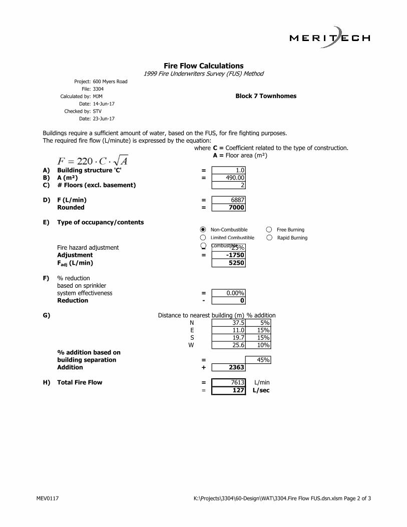
Fire Flow Calculations1999 Fire Underwriters Survey (FUS) Method
Project: 600 Myers Road
File: 3304
Calculated by: MJM
Date: 14-Jun-17
Checked by: STV
Date: 23-Jun-17
Buildings require a sufficient amount of water, based on the FUS, for fire fighting purposes.
The required fire flow (L/minute) is expressed by the equation:
where C = Coefficient related to the type of construction.
A = Floor area (m²)
A) Building structure 'C' = 1.0
B) A (m²) = 490.00
C) # Floors (excl. basement) 2
D) F (L/min) = 6887
Rounded = 7000
E) Type of occupancy/contents
Fire hazard adjustment = -25%
Adjustment = -1750
Fadj (L/min) 5250
F) % reduction
based on sprinkler
system effectiveness = 0.00%
Reduction - 0
G) Distance to nearest building (m) % addition
N 37.5 5%
E 11.0 15%
S 19.7 15%
W 25.6 10%
% addition based on
building separation = 45%
Addition + 2363
H) Total Fire Flow = 7613 L/min
= 127 L/sec
Block 7 Townhomes
Non-Combustible
Limited Combustible
Combustible
Free Burning
Rapid Burning
MEV0117 K:\Projects\3304\60-Design\WAT\3304.Fire Flow FUS.dsn.xlsm Page 2 of 3

Fire Flow Calculations1999 Fire Underwriters Survey (FUS) Method
Project: 600 Myers Road
File: 3304
Calculated by: MJM
Date: 14-Jun-17
Checked by: STV
Date: 23-Jun-17
Buildings require a sufficient amount of water, based on the FUS, for fire fighting purposes.
The required fire flow (L/minute) is expressed by the equation:
where C = Coefficient related to the type of construction.
A = Floor area (m²)
A) Building structure 'C' = 1.0
B) A (m²) = 395.00
C) # Floors (excl. basement) 2
D) F (L/min) = 6184
Rounded = 6000
E) Type of occupancy/contents
Fire hazard adjustment = -25%
Adjustment = -1500
Fadj (L/min) 4500
F) % reduction
based on sprinkler
system effectiveness = 0.00%
Reduction - 0
G) Distance to nearest building (m) % addition
N 36.6 5%
E 25.6 10%
S 19.7 15%
W 2.4 25%
% addition based on
building separation = 55%
Addition + 2475
H) Total Fire Flow = 6975 L/min
= 116 L/sec
Block 8 Townhomes
Non-Combustible
Limited Combustible
Combustible
Free Burning
Rapid Burning
MEV0117 K:\Projects\3304\60-Design\WAT\3304.Fire Flow FUS.dsn.xlsm Page 3 of 3

Date: June 13, 2017 File #: E18-10/CA
Christopher Togeretz, P. Eng, Meritech Engineering 1315 Bishop St N, Suite 202 Cambridge, ON N1R 6Z2 t. 519.623.1140 ext 214 [email protected] Dear: Chris Re: 600 Myers Rd, Cambridge Please find the results of the modeling simulations for boundary conditions requested on April 28, 2017. The results included a figure showing the locations of the nodes from the Region’s model. Attached are a series of spreadsheets containing results for Average Day, Maximum Day demands and available fire flows for Node JCT_17644 located at the intersection of Lisbon Pines Rd and Slater St. The diurnal 24 hour demand distribution accounts for the minimum hour and peak hour peaking factors. The minimum hourly demand on the average day represents the minimum hour, and the maximum hourly demand on the maximum day represents the peak hour. Demands as applied to nodes:
Node Elevation (mASL)
Residential Demand Fire Flow Results
Ave Day(L/s)
Max Day(L/s)
Design Flow (L/s)
Design Pressure (m)
JCT_17644 297.0 0.25 0.50 321.2 14.0
A fire flow analysis shows the maximum flow available at a node with an associated design pressure during the maximum day scenario while maintaining the minimum design pressure of 14 m (140 kPa) at all nodes within the pressure zone.

- 2 -
If you have any questions, please contact me. Kevin Dolishny P.Eng. Senior Project Engineer, Servicing and Development Planning t. 519.575.4757 x 3862 e-mail: [email protected] cc John Holowackyj. Region of Waterloo

AvgDayMaxDay
CAM 1a Infowater
JCT_17644 Average Day 24 Hour Simulation JCT_17644 Maximum Day 24 Hour Simulation
Time Demand (L/s) Head (m) Pressure (m) Time Demand (L/s) Head (m) Pressure (m)00:00 hrs 0.17 349.09 52.09 00:00 hrs 0.28 349.09 52.09
01:00 hrs 0.14 349.09 52.09 01:00 hrs 0.19 349.09 52.09
02:00 hrs 0.18 349.09 52.09 02:00 hrs 0.24 349.09 52.09
03:00 hrs 0.18 349.09 52.09 03:00 hrs 0.32 349.08 52.08
04:00 hrs 0.17 349.09 52.09 04:00 hrs 0.30 349.09 52.09
05:00 hrs 0.16 349.09 52.09 05:00 hrs 0.32 349.09 52.09
06:00 hrs 0.23 349.09 52.09 06:00 hrs 0.49 349.07 52.07
07:00 hrs 0.33 349.07 52.07 07:00 hrs 0.75 349.03 52.03
08:00 hrs 0.37 349.06 52.06 08:00 hrs 0.76 349.03 52.03
09:00 hrs 0.35 349.07 52.07 09:00 hrs 0.61 349.05 52.05
10:00 hrs 0.36 349.07 52.07 10:00 hrs 0.56 349.06 52.06
11:00 hrs 0.36 349.07 52.07 11:00 hrs 0.57 349.06 52.06
12:00 hrs 0.34 349.07 52.07 12:00 hrs 0.55 349.06 52.06
13:00 hrs 0.33 349.07 52.07 13:00 hrs 0.55 349.06 52.06
14:00 hrs 0.30 349.07 52.07 14:00 hrs 0.51 349.07 52.07
15:00 hrs 0.30 349.08 52.08 15:00 hrs 0.48 349.07 52.07
16:00 hrs 0.32 349.07 52.07 16:00 hrs 0.56 349.06 52.06
17:00 hrs 0.34 349.07 52.07 17:00 hrs 0.63 349.05 52.05
18:00 hrs 0.38 349.06 52.06 18:00 hrs 0.71 349.04 52.04
19:00 hrs 0.40 349.06 52.06 19:00 hrs 0.84 349.02 52.02
20:00 hrs 0.41 349.06 52.06 20:00 hrs 0.94 349.00 52.00
21:00 hrs 0.37 349.06 52.06 21:00 hrs 0.97 348.99 51.99
22:00 hrs 0.32 349.07 52.07 22:00 hrs 0.76 349.03 52.03
23:00 hrs 0.24 349.08 52.08 23:00 hrs 0.47 349.07 52.07
Average Day HGL: 349.07 Maximum Day HGL: 349.06
Minimum Hour: 349.09 Peak Hour: 348.99
600 Myers Rd CAM results 13/06/2017

Hydrant Curve
Available Flow (L/s)
Residual Pressure (m)
Fire Flow Analysis
0.0 52.1 Fire Flow Node: JCT_1764410.0 52.0 Design Flow (L/s): 321.220.0 51.8 Design Pressure (m): 14.030.0 51.640.0 51.350.0 50.960.0 50.5 Design Flow: The final adjusted flow at the node to maintain the minimum design70.0 50.0 pressure (14m (140 kPa)) at ALL locations within the pressure zone.80.0 49.590.0 48.9 Design Pressure: The lowest allowable pressure at the node to maintain the minimum design
100.0 48.2 pressure (14m (140 kPa)) at ALL locations within the pressure zone.110.0 47.5120.0 46.7 Critical Node ID: The constraining node within the pressure zone that drops to the minimum design130.0 45.9 pressure of (14m (140 kPa)) during the design flow.140.0 45.0150.0 44.1160.0 43.1170.0 42.1180.0 41.0190.0 39.8200.0 38.6210.0 37.4220.0 36.1230.0 34.8240.0 33.4250.0 31.9260.0 30.4270.0 28.9280.0 26.8290.0 23.7300.0 20.7310.0 17.6320.0 14.4321.2 14.0 0.0
10.0
20.0
30.0
40.0
50.0
60.0
0.0 50.0 100.0 150.0 200.0 250.0 300.0 350.0
Pre
ssu
re (
m)
Flow (L/s)
Maximum Allowable Flow
600 Myers Rd CAM results 6/9/2017
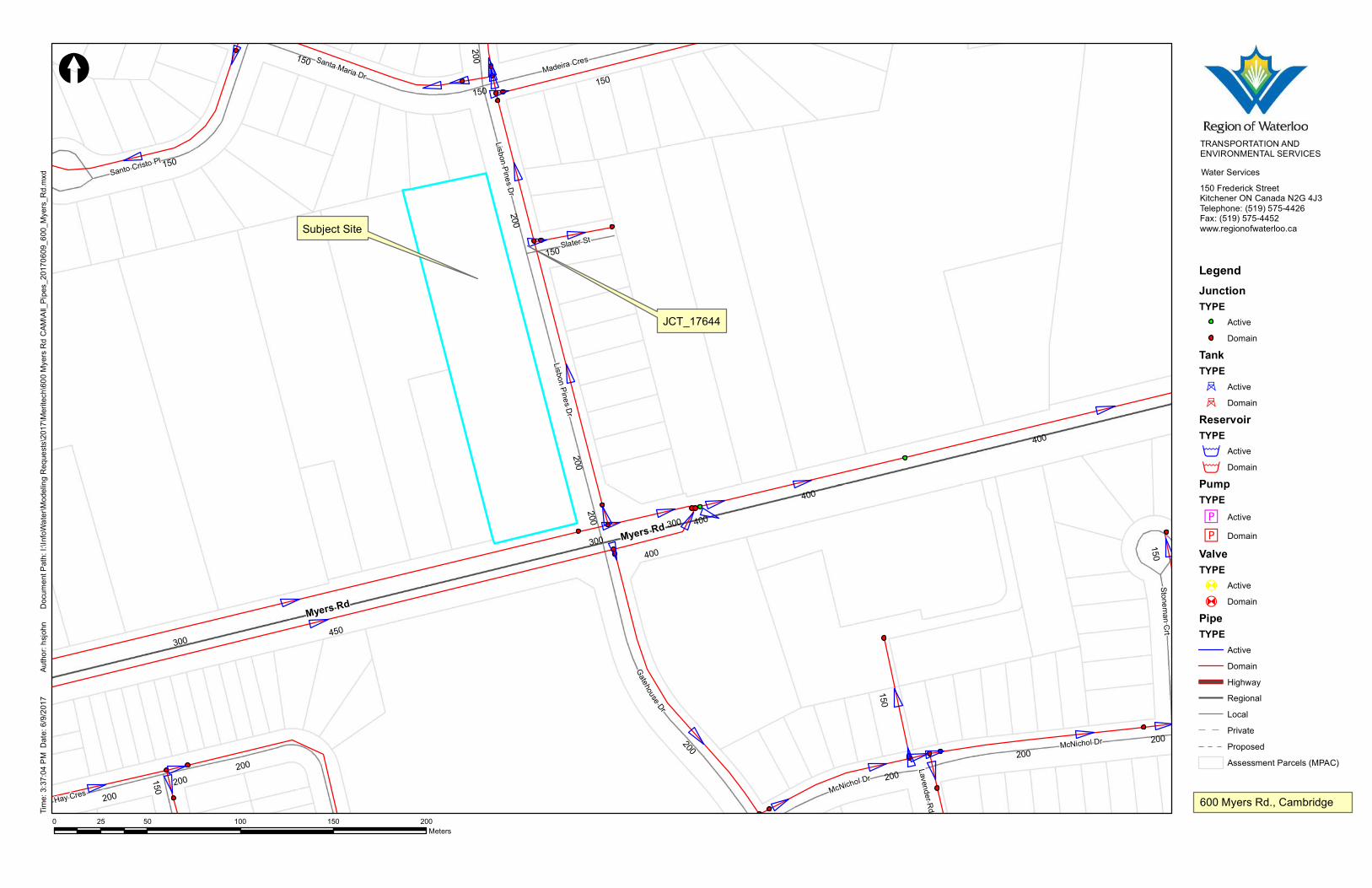
Myers Rd
Myers Rd
Gatehouse Dr
McNichol Dr
Lisbon Pines DrHay Cres
Santa Maria Dr
Santo Cristo Pl
Madeira Cres
Stoneman Crt
Slater St
Lavender Rd
Lisbon Pines Dr
McNichol Dr
450300
200
150
400
200
400
200
200
400
150
400
300
150
150
200
150
150
300
200 200200
150
150
200200
200
TRANSPORTATION ANDENVIRONMENTAL SERVICESWater Services150 Frederick StreetKitchener ON Canada N2G 4J3Telephone: (519) 575-4426Fax: (519) 575-4452www.regionofwaterloo.ca
0 50 100 150 20025Meters
[Tim
e: 3:3
7:04 P
M D
ate: 6
/9/20
17Do
cume
nt Pa
th: I:\
InfoW
ater\M
odeli
ng R
eque
sts\20
17\M
eritec
h\600
Mye
rs Rd
CAM
\All_
Pipes
_201
7060
9_60
0_My
ers_R
d.mxd
Autho
r: hsjo
hn
LegendJunctionTYPE
ActiveDomain
TankTYPE^ Active^ Domain
ReservoirTYPE> Active> Domain
PumpTYPEM Active
M DomainValveTYPE
A Active
A DomainPipeTYPE
ActiveDomainHighwayRegionalLocal Private ProposedAssessment Parcels (MPAC)
JCT_17644
600 Myers Rd., Cambridge
Subject Site

K: \Pro j ec ts \3304\60-Des ign\3304 .Func t i ona l Se rv ic ing . rp t .docx
Appendix E: Pre-Submission Comments

Development & Infrastructure Department
Development Planning Section
50 Dickson Street, 3rd Floor, P.O. Box 669
Cambridge ON N1R 5W8
Tel: (519) 621-0740
Fax: (519) 622-6184
TTY: (519) 623-6691
Page 1 of 16
Development Pre-Consultation Comments
Pre-Consultation:
To: Will-O-Homes
41 Jadestone Crt
Kitchener, ON N2A 3X7
Subject: D12/17, 600 Myers Rd, CON 10 PT LOT 5
Zoning: R4
Official Plan (2012) Designation: Low / Medium Density Residential
Proposal: Applicant submitted two options 1) to develop 600 Myers
Road with 27 townhouse units. Option No. 2 proposes 6
townhouse units 20 semi-detached houses. The property is
designated Low/Medium Density Residential in the City's
Official Plan and is currently zoned R4 (single-detached). A
Zoning By-law Amendment and Plan of Subdivision will be
required. Planning staff will be requesting a road stub to
align with Slater Street to allow for future development to
occur on the adjacent lands to the west.
Please note that the comments are based on the proposal as submitted. Due to
changing policies and regulations, these comments are valid for a period of two
(2) years from the date of issuance of this letter.
Subdivision Coordinating Committee Comments
Meeting Date: March 30, 2017
Meeting Time: 2:25 pm
Secord Room, 2nd Floor, City Hall, 50 Dickson Street

Page 2 of 16
Aerial Photo and Zoning:
Proposal:

Page 3 of 16
Committee Comments:
City of Cambridge, Development Planning Section
Contact: James Horan
Phone: (519) 621-0740 Ext. 4528
Email: [email protected]
Development Planning – Comments:
The subject property is currently designated Low/Medium Density Residential in
the City’s Official Plan and is zoned R4 in the City Zoning By-law No. 150-85, as
amended. Two concept plans were submitted: a) 27 unit street fronting
townhouse option and b) a 26 unit townhouse option. Both options are under the
maximum density of 40 units/ha. The proposal would yield approximately 30
units per/ha.
A 20 metre road block is required to facilitate access to the lands west of the
subject property. This road does not have to be constructed; however, this will
have to be conveyed to the City as condition of Draft Approval free and clear of
any encumbrances.
Staff is supportive of the semi-detached option that incorporates a few
townhouse blocks it provides a comparable built form to the existing houses on
the east side of Lisbon Pines Drive and provides opportunities to twin the
driveways.
A Zoning By-law Amendment and Draft Plan of Subdivision is required to
facilitate the development proposal.
Demolition Control By-law applies to the existing single detached dwelling.
Parkland dedication or cash-in lieu will be required as a condition of approval of
the Draft Plan of Subdivision in accordance with the City’s Official Plan and the
Planning Act.
Currently under the City’s current Site Plan Control By-law, street townhouses
are subject to site plan control. However, if the semi-detached option is pursued,
site plan control is not applicable.
Development Planning – Submission Requirements:
Zoning By-law Amendment Application and Plan of Subdivision is required
(Plan of Subdivision Application to be submitted to the Region of
Waterloo).
Planning Justification Report is required and must address Provincial, Regional,

Page 4 of 16
and City policies such as the Provincial Policy Statement (PPS), Places to Grow
(P2G) Growth Plan, Regional Official Policies Plan (ROPP), the new Regional
Official Plan (ROP), and the City Official Plan. The Planning analysis to include
Section 8.4.2 Residential Compatibility of the 2012 Official Plan must be
addressed.
Site plan showing conceptual siting of building footprints with proposed lot lines.
Required Drawings and Reports:
Planning Justification Report
Urban Design Brief in accordance with Section 5 of the Official Plan
Traffic Noise Study
Tree Inventory and Management Plan
Functional Servicing Report (FSR)
Conceptual Building Elevations
Stormwater Management Brief
Site Servicing Plan
Site Grading & Erosion Control Plan
Original Conditions Plan
Section 59 Notice – Source Water Protection
PDFs of all Documents
Region of Waterloo, Transportation Planner
Contact: Cheryl Marcy
Phone: (519) 575-4500 Ext. 3243
Email: [email protected]
Corridor Planning Regional Road Dedication At this location Regional Road 43 (Myers Road) has a designated width in the Regional
Official Plan (ROP) of 100 feet. An approximate 7 foot road widening will be required
along the Myers Road frontage. A 25 foot (7.62m) daylighting triangle is also required at
the intersection of Myers Road and Lisbon Pines Drive. An Ontario Land Surveyor
(OLS) would have to determine the exact road widening along the roadway.
The land must be dedicated to the Region of Waterloo for road allowance purposes and
must be dedicated without cost and free of encumbrance. All land dedications should be
identified on the Site Plan.

Page 5 of 16
The Applicant must engage an OLS to prepare a draft reference plan which illustrates
the required road allowance widening. Prior to registering the reference plan the OLS
should submit a draft copy of the plan for review by the Transportation Planner. The
Applicants Solicitor will prepare the land transfer document and submit the document to
the Region’s Legal Assistant for registration.
The road widenings will be made a condition of Draft Approval for the Plan of
Subdivision.
Traffic Site Circulation & Access
The proposed accesses on Lisbon Pines Drive should meet the minimum separation
from a Regional intersection of 16 metres. This is measured from the centreline of the
access to the property line (after the road widening) abutting Myers Road.
A Regional Access Permit will be required to close the existing access along Myers
Road. There is no fee for the permit to close the existing access and can be deferred to
the Site Plan.
The applicant is advised that the Region’s Draft 2017 Transportation Capital Program
identifies Myers Road from Branchton Road to Water Street for reconstruction in 2019
with the design work already underway. For more information please contact Skylar Van
Kruistum (519) 575-4757 x3182.
The Regional Transportation Corridor Design Guidelines identifies this segment of
Regional Road 43 (Myers Road) as a Residential Connector. As such, sidewalks as
requested by the City of Cambridge should be 1.8m metres in width, located 1.0m from
the property line and identified on the Site Plan.
Stormwater Management
Storm sewers within the Regional road right-of-way are generally sized and designed to
only accommodate stormwater from the right-of-way and in some instances off road
surface drainage under existing conditions. A private stormwater connection to any
storm sewer on Myers Road will be discouraged where an alternate stormwater
connection is available, including infiltration if soil conditions and Source Protection
under the Clean Water Act permit, or if it is determined that the Myers Road storm
sewer does not have the sufficiency (condition and capacity) to accommodate private

Page 6 of 16
stormwater flows from this site. It is the responsibility of the applicant’s engineering
consultant to determine an appropriate stormwater outlet from this site and the
sufficiency of the receiving storm system if there is no other option available and to
include this information in the stormwater management report. The applicant or their
consultant should contact Mr. Malcolm Lister, manager, Technical Services for the
Region of Waterloo at 519-575-4432 or [email protected] to determine if any
engineering plans and/or further technical information for Myers Road is available which
may be of assistance.
The applicant must submit a detailed Site Grading & Drainage Control Plan(s) and Site
Servicing Plan(s) along with a Stormwater Management report (including an electronic
copy) to the Region for approval. This should include drainage details for the subject
property, abutting properties and the public road allowance so as to ensure compatible
drainage and to show thereon all existing and proposed connections to the municipal
storm sewers, sanitary sewers and water mains and all detailed erosion and siltation
control features, all to the satisfaction of the Region.
The site must be graded in accordance with the approved plan and the Regional Road
allowance must be restored to the satisfaction of the Regional Municipality of Waterloo.
Please be advised that any new servicing connections or update to the existing
servicing would require Regional approval through a separate process of Municipal
Consent. For servicing approvals please contact Nora Fleming @ 519-575-4100 x3312
Email: [email protected]
The Lot Grading and Stormwater Management plans must be submitted as part of a
complete application for the Plan of Subdivision.
Transit Planning
Grand River Transit (GRT) currently operates Route No. 54 along the Lisbon Pines
frontage of this property. GRT has identified the need for a transit easement on Lisbon
Pines Drive, immediately to the north of the future daylight triangle at the intersection
with Myers Road, to accommodate a transit shelter behind the sidewalk. This may
require reconfiguration so that the shelter does not conflict with the driveway accesses.
The easement will need to be identified on a reference plan, and the applicant will need
to enter into an easement agreement with the Region. The applicant will be required to
financially contribute to the cost of transit pads, including one landing pad and one
shelter pad. Please identify the GRT infrastructure on all plans and engineering

Page 7 of 16
drawings. For more information please contact Howard Chang at 519-585-7597 x7371.
The easement and the funding of the landing and shelter pads will be made a condition
of Draft Approval for the Plan of Subdivision.
Noise
It is the responsibility of the applicant to ensure the development is not adversely
affected by anticipated transportation and/or stationary noise impacts. In this regard the
applicant will be required to prepare an Environmental Noise Study. The noise level
criteria and guidelines for the preparation of the transportation noise study are included
in the Region of Waterloo Implementation Guideline For Noise Policies. Any
requirement for the analysis of transportation and stationary noise impacts must comply
with MOE NPC-300 Guidelines.
The noise consultant must be pre-approved by the Region of Waterloo. The noise
consultant is responsible for obtaining current information, applying professional
expertise in performing calculations, making detailed and justified recommendations,
submitting the Consultant Noise Study Declaration and Owner/Authorized Agent
Statement along with 4 copies of the Environmental Noise Study to the Region of
Waterloo.
There is a $250 fee for the preparation of traffic forecasts and review of Environmental
Noise Studies by Region of Waterloo staff. The noise consultant preparing the
Environmental Noise Study must complete and submit a Transportation Planning Noise
Assessment Fee Form. The form can be found at
http://www.regionofwaterloo.ca/en/doingBusiness/resources/Noise_Assessment_Fee_A
pplication.pdf. As indicated on the form, traffic forecasts for noise assessments will be
prepared within 15 business days of the data of the request, but will be withheld if
payment has not been received.
The noise study will be required as part of a complete application for the Plan of
Subdivision.
Application Fees Pursuant to By-law 17-001, the Regional application fees are as follows:
o Plan of Subdivision: Pre-consultation fee (payable immediately) - $250 Submission of a complete application - $2,500, plus $250/hectare to

Page 8 of 16
a maximum fee of $10,000 o Zoning By-law Amendment - $1,000 to be submitted as part of a complete
application
Regional Development Charges Any future development on the subject lands will be subject to provisions of Regional Development Charge By-law 14-046 or any successor thereof. Summary The Region will require the following as part of the complete application for the Plan of Subdivision and Zoning By-law Amendment:
Plan of Subdivision application (1 signed original and 24 copies)
Planning Justification Report (25 copies)
Draft plan (25 copies and digital submission in keeping with the Regional Digital Submission Standards)
The proposed plans and all reports must also be submitted in digital form for the City and the Region (one copy each).
Site Grading & Drainage Control Plan(s) and Site Servicing Plan(s) along with a Stormwater Management report ( 4 copies including an electronic copy)
Noise study (4 copies) All other requirements outlined above will be implemented as conditions of Draft Approval.
Please note: Comments and requirements are based on the information provided
by the applicant during the pre-submission process. Should new details and/or
information become available through the application process, requirements are
subject to change.
Region of Waterloo, Community Planning
Contact: Carolyn Crozier
Phone: (519) 575-4500 Ext. 3657
Email: [email protected]
Community Planning Plan of Subdivision submission requirements

Page 9 of 16
The Region will require copies of the application (1 signed original and 24 copies), a planning justification brief (25 copies), draft plan (25 paper copies and digital submission in keeping with the Regional Digital Submission Standards), and application fee. The proposed plans and all reports must also be submitted in digital form for the City and the Region (one copy each). Hydrogeology and Source Water Protection The applicant is required to determine if any Prohibitions and/or Risk Management Plan requirements apply to this property as prescribed under the Clean Water Act. The applicant can visit https://taps.regionofwaterloo.ca to make this determination. The applicant is advised that any existing domestic supply wells on the subject lands need to be decommissioned by a licensed well contractor in accordance with O. Reg. 903 (as amended). Water Services The applicant is advised that no connection to regional watermains is permitted in accordance with Section B.2.4.7 of the Design Guidelines and Supplemental Specifications for Municipal Services for January 2017.
City of Cambridge, Building
Contact: Tanya Gies
Phone: (519) 621-0740 ext. 4543
Email: [email protected]
• No comments.
City of Cambridge, Economic Development
Contact: Trevor McWilliams
Phone: (519) 740-4683 Ext. 4800
Email: [email protected]
• No comments.
City of Cambridge, Community Services Department
Contact: Paul Willms
Phone: (519) 740-4681 Ext.4262
Email: [email protected]

Page 10 of 16
• Comments forthcoming
City of Cambridge, Planner - Heritage
Contact: Laura Waldie
Phone: (519) 621-0740 Ext. 4788
Email: [email protected]
• No comments.
City of Cambridge, Senior Planner - Environmental
Contact: Kathy Padgett
Phone: 519-621-0740 ext. 4826
Email: [email protected]
The site is located within a Source Water Protection Area and requires a Notice of
Source Protection Plan Compliance (Section 59 Notice) from the Region
(taps.regionofwaterloo.ca) as part of a complete application.
City of Cambridge, Development Engineering
Contact: Adam Ripper
Phone: (519) 621-0740 Ext. 4778
Email: [email protected]
Submission Requirements
Provide a Site Grading Plan
Provide a Site Servicing Plan
Provide a Functional Servicing Report
Development Engineering Comments
Servicing
City Records indicate that the following municipal services are located on Lisbon
Pines drive adjacent to the subject site:
- 200mm Watermain
- 250mm Sanitary Sewer
Page 11 of 16
- 750mm Storm Sewer
It is noted that the Sanitary Sewer is located at a significant depth and new
connections will result in substantial disturbance to the road. As such
replacement of curb, sidewalk and asphalt along the entire frontage of the
development may be required.
Due to the depth of servicing, it is preferable to install all services at once, rather
than on a lot by lot basis.
For depths over 5.0m a secondary collection system is typically required (as per
DGSSMS section B.3.1.10)
A sanitary capacity assessment application has been submitted by the applicant
to the City. The City will confirm if sufficient capacity for the development is
available once the assessment has been completed by the City.
All piped outlets should be sized for the 5-year design storm. The City’s 5 year
IDF parameters are a = 1219.8, b = 10.5 and c = 0.823. Provide hydraulic
calculations.
The servicing report should include a review of the available storm and sanitary
outlets and available capacities.
Show all existing municipal services (water, storm and sanitary) within the
municipal ROW across the entire frontage.
By-Law #146-03 permits only one (1) water service and meter per property. The
City does not make provision(s) for sub-metering on a property.
The City must approve the optimum water meter size (and its location). Submit
water demand calculation sheets for the entire property/development, per the
City’s Water Customer Data Sheets standard.
Any redundant water service is to be capped at the watermain at 100% Owner’s
expense (works completed by City’s Public Works Division).
Any redundant sanitary service(s) are to capped at the property line.
Grading
Curb and gutter along the municipal right-of-way is to extend through the
entrances.
Roof leader discharge locations to be indicated.
No sheet flow from any impervious areas is allowed to be discharged directly

Page 12 of 16
onto the ROW.
Provide centerline of road elevations for full frontage.
Provide existing geodetic elevations of adjacent properties along property lines
for a minimum of 10 metres off the applicant’s property line.
Use drainage arrows to indicate existing surface drainage of abutting properties
along property lines.
Erosion & Sediment Control
A $5,000 erosion control security deposit is required to ensure compliance with
the approved erosion (and siltation) control measures.
Provide silt/erosion control fencing for control of siltation/erosion to abutting
properties and ROW.
General
Myers Road is a Regional Road. All proposed site works adjacent to Regional
Roads require Regional Municipality of Waterloo (RMOW) approval(s).
All applicable work within the road allowance for the proposed development,
including but not limited to site services, curb cuts, driveway ramps and
sidewalks, will be completed by the City’s Public Works Division at 100%
Owner’s expense.
Cost estimates for work within road allowance are prepared by City Staff upon
receipt of the estimate fee of $200.00 plus HST.
Upon project completion, the Engineering Department will require a signed and
sealed letter of compliance from a Professional Engineer confirming that the site
grading has been inspected and all earth grade surfaces are in general
compliance with the approved grades and cross-sections and are within
tolerances as specified under the applicable OPSS(s).
No alteration of grading is permitted on site until the applicant enters into a site
plan or subdivision servicing agreement with the City. Grading of site is subject to
Grading Control By-Law No. 160-09.
Under NO circumstance is a connection to the municipal water system to be
made without the consent and presence of City of Cambridge Public Works staff.
Please note that, per Regulatory requirements, only certified water operators
may isolate watermains or reconnect isolated watermains.

Page 13 of 16
City of Cambridge, Transportation Engineering
Contact: Jason Leach
Phone: (519) 621-0740 Ext. 4268
Email: [email protected]
Conveyance of property within the daylight triangle to the City will be required.
The daylight triangle area consists of the point where the extended curb lines of
Myers Road and Lisbon Pines Drive meet to 15m west on Myers Road, 15m
north on Lisbon Pines Drive and those two points connected.
Road connection on Lisbon Pines Dr at Slater St to Clover Ave.
Transportation Engineering Comments
Street light poles must be a minimum of 1.5m from any proposed accesses. If
a street light pole is required to be relocated the following process may be
required:
o The applicant is required to submit a revised street light design
incorporating the new access, the affected street light(s) and the street
lights immediately adjacent. The street light design is to be completed by
an Electrical Engineer trained in street light design and must meet the
I.E.S. RP-8-00 Guide for the Design of Roadway Lighting.
o Following approval of the new street light design by the City of Cambridge
(City), the City will obtain a cost estimate from Cambridge and North
Dumfries Hydro (CNDH) to implement the new street light design.
o The applicant will be required to submit a cheque to the City for 110% of
the cost estimate for the implementation of the new street light
design. The cheque will be required prior to site plan approval.
o CNDH will carry out the implementation of the new street light design on
behalf of the City.
o The City will return any remaining funds to the applicant.
City of Cambridge, Fire Department
Contact: Mark Yantha
Phone: (519) 621-6001 Ext. 2225
Email: [email protected]
Page 14 of 16
Show all fire hydrants. (ensure present)
Energy+ Inc.
Contact: Helen Robinson
Phone: (519) 621-3530
Email: [email protected]
Energy+ Inc. has no objection to the request by the Applicant for a Zoning By-law
amendment to facilitate the development of either twenty seven (27) street fronting
townhouses or six (6) townhouses and twenty (20) semi-detached units requiring a Plan
of Subdivision. Our comments for the proposed Subdivision Service Agreement will
include:
1) The Owner/Applicant will be required to enter into an agreement with Energy+
Inc. to establish the conditions and costs to provide electrical service to this
development.
2) The Owner/Applicant will be responsible for all costs associated with the
relocation and/or upgrade of the existing electrical plant, if required as a result of
this proposal.
3) The Owner/Applicant will be required to grant easements to the satisfaction of
Energy+ Inc. if required as a result of this proposal.
Grand River Conservation Authority
Contact: John Brum
Phone: (519) 621-2763 Ext. 2233
Email: [email protected]
Please be advised that the subject lands are outside of our areas of interest
(refer to attached map). However, there is no information with regards to
stormwater management. We trust that the City of Cambridge would ensure that
appropriate stormwater management measures will be implemented in the
development of these lands.
If future draft plan of subdivision/condominium applications are circulated by the
Region of Waterloo, the GRCA will provide comments and the applicant is
advised that GRCA plan review fees will be applicable in accordance with the fee

Page 15 of 16
schedule in effect at that time.
Waterloo Region District School Board
Contact: Shawn Callon
Phone: (519) 570-0003 Ext. 4308
Email: [email protected]
• No comments.

Page 16 of 16

K: \Pro j ec ts \3304\60-Des ign\3304 .Func t i ona l Se rv ic ing . rp t .docx
Appendix F: Geotechnical Report Excerpts


Meritech Engineering 1315 Bishop Street North Suite 202 Cambridge ON N1R 6Z2 t 519.623.1140 f 519.623.7334