Embed Size (px)
Citation preview

Archaeological Monitoring Report
Fulton Street Corridor Revitalization Project:
DeLury Square and Gold Street Drainage Pipes
New York, New York
Prepared for: Lower Manhattan Development Corporation
Prepared by: AKRF, Inc.
440 Park Avenue South
New York, New York 10016
Molly McDonald, RPA
March 2010

Management Summary
SHPO Project Review Number: 06PR06595
Involved Agencies: United States Department of Housing and Urban Development New York City Department of Parks and Recreation New York City Department of City Planning New York City Department of Transportation New York City Department of Citywide Administrative Services New York City Department of Housing Preservation and Development Phase of Survey: Archaeological Monitoring Location Information
Location: DeLury Square (Block 94) (northeast corner of Gold and Fulton Streets); and Gold Street sidewalk and streetbed between Fulton and Ann Streets
County: New York Monitoring Area Length: Approx. 150 feet (46 meters) Width: Approx. 80 feet (24 meters) Maximum Depth: 14 feet (4.3 meters) below ground surface USGS 7.5 Minute Quadrangle Map: Jersey City Quadrangle Results of Archaeological Monitoring Number and name of prehistoric sites identified: None Number and name of historic sites identified: None Number and name sites recommended for Phase II/avoidance: None Field Archaeologists
Molly McDonald, RPA Elizabeth D. Meade, RPA
A. Michael Pappalardo, RPA Report Author(s)
Molly McDonald, RPA
Date of Report: March 2010

2
A. INTRODUCTION
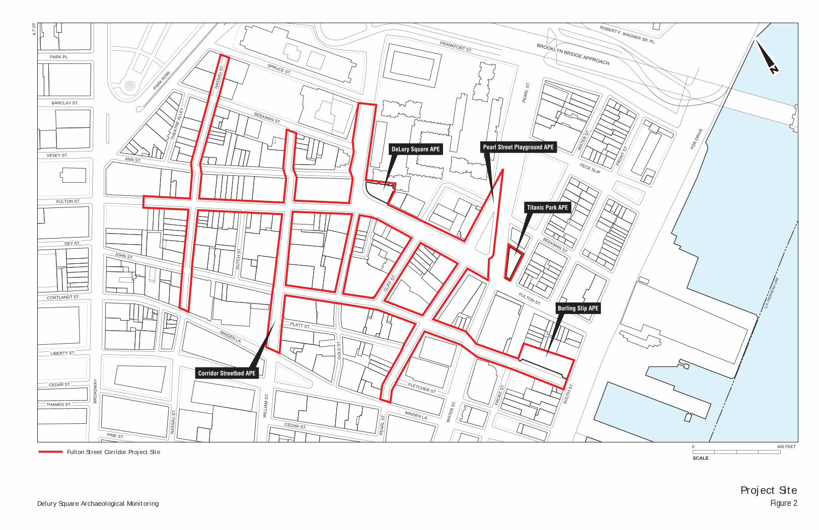
The City of New York plans to enhance Fulton and Nassau Streets and their environs to create a vibrant retail corridor serving the surrounding commercial and residential sectors as well as the burgeoning visitor market. As the project is necessary to the continued revitalization of Lower Manhattan, the Lower Manhattan Development Corporation (LMDC) would provide a portion of the funding. The core components of the project include improvements to the streetscape and to the storefronts and facades of buildings that contribute to the heritage and experience of the corridor, as well as the creation, expansion or improvement of open space within the project area. As part of the Fulton Street Corridor Improvement Project, John DeLury Plaza, the small paved plaza and lawn located at the intersection of Fulton Street and Gold Street, would be joined by the elimination of a traffic lane to create a unified public space.
The Fulton Street Corridor Revitalization Project Environmental Assessment (AKRF December 2007) was completed in December 2007 in compliance with the National Environmental Policy Act (NEPA), the State Environmental Quality Review Act (SEQRA), and New York City Environmental Quality Review (CEQR). Potential effects on historic resources were also considered in conformance with Section 106 of the National Historic Preservation Act of 1966 (NHPA) and the New York State Historic Preservation Act of 1980 (SHPA). As part of this environmental review process, five Areas of Potential Effect (APEs) for archaeological resources were identified. These corresponded to five separate project elements or locations expected to result in excavation or ground disturbance. Archaeological documentary studies were completed for each of these APEs by Historical Perspectives, Inc. including Burling Slip (November 2006); DeLury Square (April 2007); Titanic Memorial Park (January 2007); the Pearl Street Playground (August 2007); and the Corridor Streetscape Improvements (March 2007; Addendum August 2007) (see Figures 1 and 2).
The Phase IA study for DeLury Square concluded that historic period archaeological resources could be present beneath 9 feet or more of disturbance (varying by location). The project was not expected to impact archaeologically sensitive areas to sensitive depths at DeLury Square. Therefore, no further archaeological work was recommended for the APE. A Programmatic Agreement (PA) for the project between the LMDC and the New York State Historic Preservation Office (SHPO) was signed on March 23, 2008. The PA stated that if revised project plans resulted in potential impacts to archaeologically sensitive locations, archeological testing or monitoring would be required in these areas in coordination with SHPO and New York City Landmarks Preservation Commission (LPC).
Refined project plans were subsequently developed which included the installation of drainage pipes in the DeLury Square APE and the adjacent sidewalk and streetbed of Gold Street requiring excavation to between 5 and 13 feet below ground surface, varying by location. In certain locations, the planned excavation was projected to impact archaeologically sensitive areas identified in the Phase IA documentary study for DeLury Square (HPI 2007) and Gold Street portion of the Corridor Streetscape Improvements Phase IA (March 2007; Addendum August 2007). An Archaeological Monitoring Plan for DeLury Square was prepared by AKRF (May 2009) and was approved by LPC and SHPO.
This Monitoring Report presents the results of archaeological monitoring within the DeLury Square APE and in the adjacent Gold Street sidewalk and streetbed, which was implemented from September 2009 to March 2010. No potentially significant archaeological resources were encountered during monitoring.
B. SUMMARY OF PREVIOUS DOCUMENTARY STUDY
Prior to commencement of project-related construction, the DeLury Square APE consisted of a landscaped area containing plantings and seating, located on Block 94, at the northeast1 intersection of Fulton and Gold Streets in Lower Manhattan. The APE abuts a 27-story building that fronts onto Gold Street and a single-story building that fronts on Fulton Street.
A Phase IA archaeological documentary study was completed for the DeLury Square APE by Historical Perspectives, Inc. in April 2007. A Phase IA archaeological documentary study was also completed for the 1 For clarity, directions are simplified such that Fulton Street is considered to run east-west and Gold
Street is considered to run north-south.

Table of Contents
3
Streetscape Improvements APE (HPI March 2007), which included streetbeds and sidewalks of the Fulton Street Corridor. A small portion of this APE, consisting of Gold Street immediately west of DeLury Square, was affected by the proposed drainage pipe installation at DeLury Square. The findings relating to this portion of the Street Improvements APE and the entirety of the DeLury Square APE are summarized below.
BRIEF HISTORY OF THE PROJECT SITE
PREDEVELOPMENT CONDITIONS AND PRECONTACT PERIOD
As described in greater detail in the Phase IA studies, the project site is located within the Manhattan prong, an eastern projection of the New England Upland Physiographic Province. Prior to landfilling and development of streets in Lower Manhattan, the DeLury Square APE “was characterized as a terrace lying between the top of a rise to the northwest and a slope down to the shoreline to the south and east” (HPI 2007: 6). Native Americans likely utilized resources in the vicinity, however, the APE was not found to possess potential for precontact archaeological resources because such resources are generally shallow and would likely have been disturbed by historic and modern development. Based on a comparison of historic and modern maps, it was found that the elevation of the project area was reduced by roughly five feet between the mid-and late 19th century. Today the elevation of the APE remains at its late 19th century level of 23.1 feet above sea level. This grading, which was probably undertaken to create a gentler slope towards the East River, would likely have destroyed any precontact period resources that may have existed in the APE.
DELURY SQUARE HISTORIC PERIOD SITE HISTORY
The APE is comprised of the interior of former Block 94, essentially containing the rear portions of ten historic lots (see Figure 3). Gold and Fulton Streets were reconfigured and widened in the 1970s, thus removing the southern and western portions of Block 94. Every lot within the APE appears to have been developed by the mid-18th century, when the block was part of a residential neighborhood. Towards the end of the 18th century, concurrent with the rising prominence of the East River waterfront and the Wall Street commercial center, commercial uses became dominant in the APE. Documented owners and/or inhabitants during this period had primarily Dutch and British surnames and had professions that included shopkeepers, merchants and bakers. In the late 18th and early 19th century, several businesses were documented on project site lots and in some cases, owners and their families inhabited the same lots. Lot 10, for example, was the home of the Sharpe and Sutphen whip factory as well as the Sutphen family by 1823. John Wood, a baker, owned Lot 11 from 1785, and likely lived there and operated a business there through at least 1821. In 1851, a tailor worked and resided in the building on the lot. Several commercial establishments were located on Lot 12 in the 1840s and 1850s, including a store owned by Amos Pilsbury; and a sandpaper and spices dealership owned by Joseph Isham. A bakery and a boardinghouse were located on Lot 13 in the 1820s. Lot 26 had several owners in the late 18th to mid 19th century, including (ca. 1814-1830) William and Edward Higgens (painters) and Edward Higgens’ family; and (ca. 1844-8) James Kelly, who lived on the lot and operated a bakery there. Commercial or mixed commercial and residential uses were also recorded for the other project site lots during the period. Only a few deviations from this pattern have been recorded, such as the residency of Reverend John Sanford on Lot 10 in the early 19th century.
SIDEWALKS AND STREETBEDS
As noted, refined project plans indicated that a small portion of the Street Improvements APE would be impacted by the proposed drainage pipe installation at DeLury Square. The affected portion is located in the streetbed and east sidewalk of Gold Street between Fulton and Ann Streets. Due to the reconfiguration and widening of Gold and Fulton Streets in the 1970s, the southern and western portions of Block 94 became part of the sidewalk and streetbeds. As described in the lot history summaries above, these lots were developed residentially and commercially in the 18th and 19th centuries. The original portion of Gold Street (west of former Block 94), was laid out in 1755. Wood water mains and other historic infrastructure features may have existed in the street bed in the late 18th or early 19th centuries.
4
GROUND DISTURBANCE
Each of the former lots that now make up DeLury Square was occupied by a building with a basement in the late 19th or 20th century (see Figure 3). Basement depths ranged between 9 and 20 feet below ground surface.
Portions of the current streetbed and sidewalk adjacent to DeLury Square would also have been disturbed by basement construction on the former lots. The remainder of the Gold Street streetbed (west of former Block 94) may not have been impacted by basement construction; however at least 3 feet below ground surface were likely disturbed by modern utility installation.
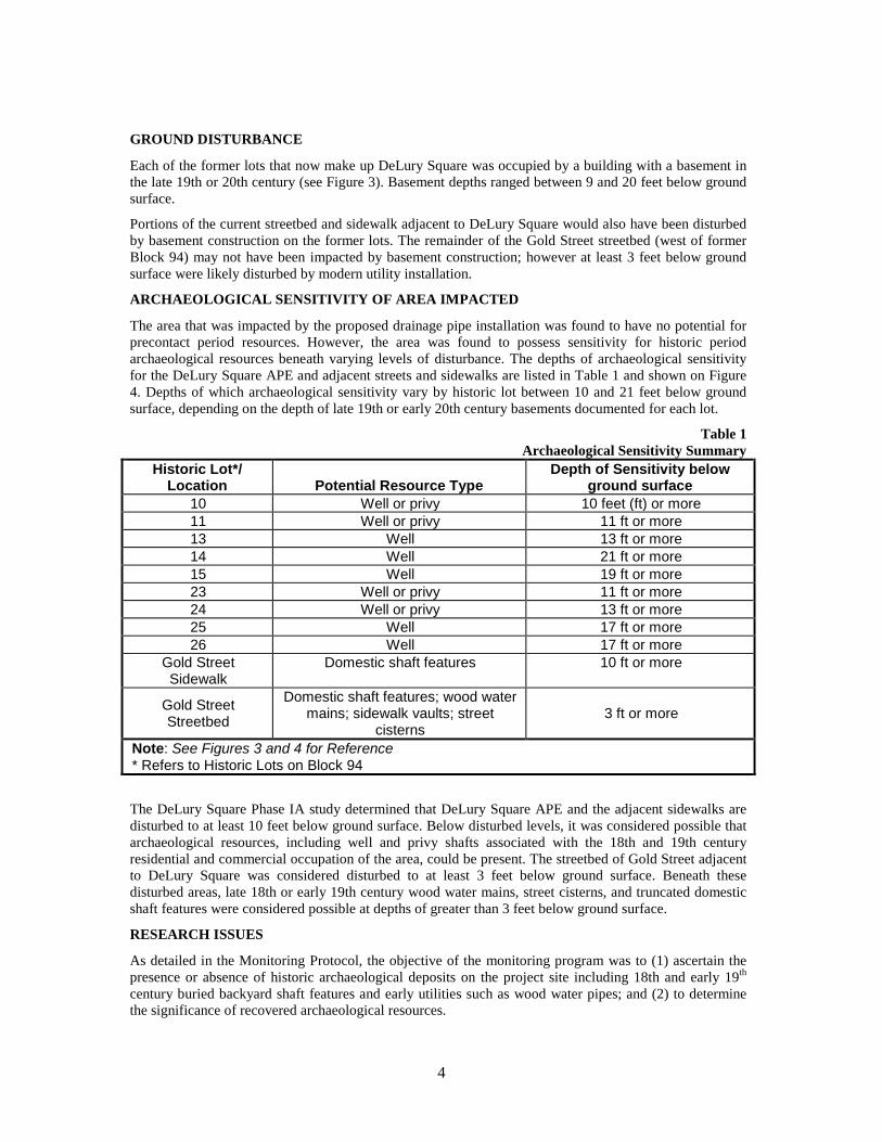
ARCHAEOLOGICAL SENSITIVITY OF AREA IMPACTED
The area that was impacted by the proposed drainage pipe installation was found to have no potential for precontact period resources. However, the area was found to possess sensitivity for historic period archaeological resources beneath varying levels of disturbance. The depths of archaeological sensitivity for the DeLury Square APE and adjacent streets and sidewalks are listed in Table 1 and shown on Figure 4. Depths of which archaeological sensitivity vary by historic lot between 10 and 21 feet below ground surface, depending on the depth of late 19th or early 20th century basements documented for each lot.
Table 1 Archaeological Sensitivity Summary
Historic Lot*/ Location Potential Resource Type
Depth of Sensitivity below ground surface
10 Well or privy 10 feet (ft) or more 11 Well or privy 11 ft or more 13 Well 13 ft or more 14 Well 21 ft or more 15 Well 19 ft or more 23 Well or privy 11 ft or more 24 Well or privy 13 ft or more 25 Well 17 ft or more 26 Well 17 ft or more
Gold Street Sidewalk
Domestic shaft features 10 ft or more
Gold Street Streetbed
Domestic shaft features; wood water mains; sidewalk vaults; street
cisterns 3 ft or more
Note: See Figures 3 and 4 for Reference * Refers to Historic Lots on Block 94
The DeLury Square Phase IA study determined that DeLury Square APE and the adjacent sidewalks are disturbed to at least 10 feet below ground surface. Below disturbed levels, it was considered possible that archaeological resources, including well and privy shafts associated with the 18th and 19th century residential and commercial occupation of the area, could be present. The streetbed of Gold Street adjacent to DeLury Square was considered disturbed to at least 3 feet below ground surface. Beneath these disturbed areas, late 18th or early 19th century wood water mains, street cisterns, and truncated domestic shaft features were considered possible at depths of greater than 3 feet below ground surface.
RESEARCH ISSUES
As detailed in the Monitoring Protocol, the objective of the monitoring program was to (1) ascertain the presence or absence of historic archaeological deposits on the project site including 18th and early 19th century buried backyard shaft features and early utilities such as wood water pipes; and (2) to determine the significance of recovered archaeological resources.

Table of Contents
5
Artifacts recovered from any shaft features associated with the occupation of the site would have been compared to artifact assemblages recovered from shaft features associated with other working class families and small businesses in other parts of Lower Manhattan and the city from comparable time periods. Assemblages could also be compared and contrasted to backyard shaft feature assemblages in the vicinity from the same time period to gain information on the lifeways and culture of families in this area in relation to the changing patterns in the broader region. If wood water pipes or other historic infrastructure features were encountered in the Gold Street streetbed, these features may have contributed to our understanding of early water and sewer systems in New York City. They would have been compared and contrasted to similar finds in Lower Manhattan and early infrastructure features documented in other cities, such as Philadelphia and Boston, in order to gain insight into New York City’s water supply system in the larger American context.
C. MONITORING
Archaeological monitoring is defined as “the observation of construction excavation activities by an archaeologist in order to identify, recover, protect and/or document archaeological information or materials” (NYAC 2002:1). Furthermore, its purpose is “to insure that archaeological resources are not disturbed and that unforeseen discoveries are handled properly” (LPC 2002:13). All monitoring and hand excavation of archaeological deposits by the archaeological team was conducted in accordance with the Monitoring Protocol and the guidelines established by LPC (2002), the New York Archaeological Council (NYAC 2002), and the Secretary of the Interior’s Standards and Guidelines for Archaeology and Historic Preservation (48 FR 44716).
AREA OF IMPACT
The planned design for John DeLury Plaza includes a new water feature to provide visual interest while helping to mask traffic noise; new plantings; seating to accommodate visitors, and a fence with gates at the walkway entrances to the open space. As discussed in the EA for this project, excavation for the bulk of these improvements would not affect archaeologically sensitive areas identified in the Phase IA. The only project-related construction affecting archaeologically sensitive areas was the installation of drainage pipes within the DeLury Square APE and the adjacent sidewalk and streetbed of Gold Street. Therefore, archaeological monitoring was required only for the drainage pipe installation.1
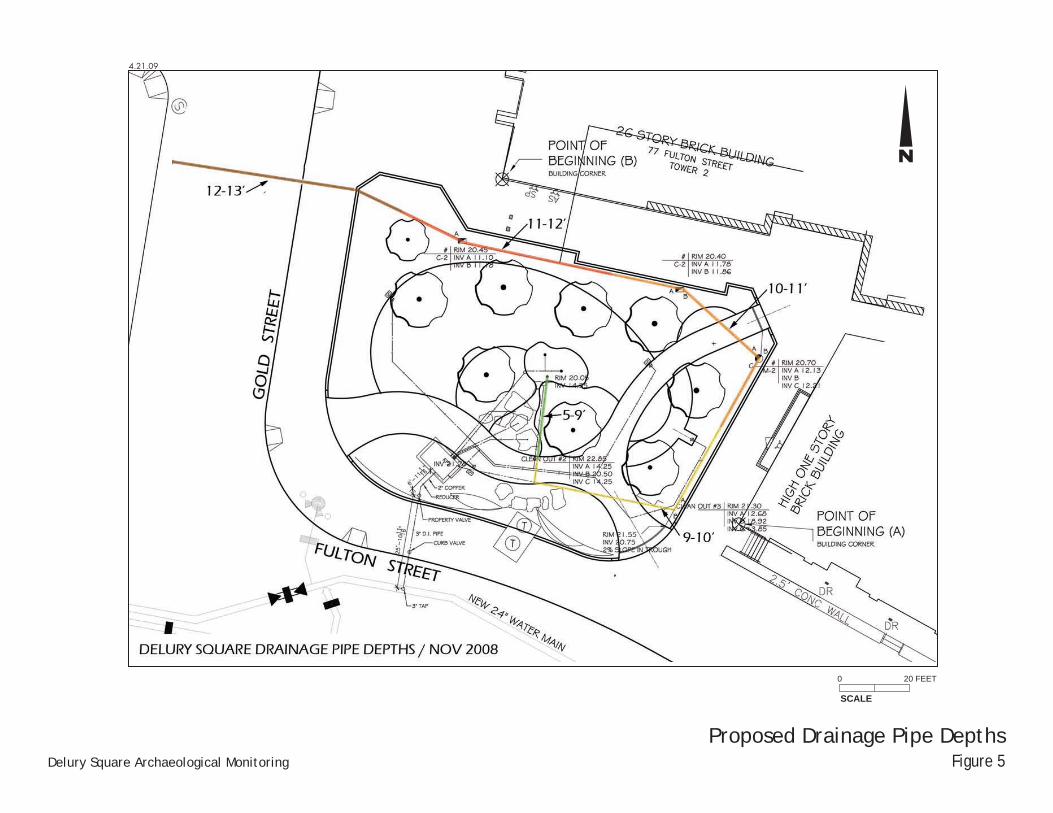
A plan showing the planned locations and depths of these drainage pipes is included as Figure 5. As illustrated on this plan, the pipes were to be installed at depths ranging from 5 feet to 13 feet. Figure 6 illustrates the areas were archaeological monitoring was considered necessary because the planned excavation exceeded disturbed depths. These include the following two segments of the pipeline:
· Eastern Portion of the Property: The segment of the planned drainage pipes running along the northern and eastern edges of the property was scheduled for excavation to between 9 and 12 feet below ground surface in areas possessing archaeological sensitivity below depths of between 9 and 12 feet below ground surface. Therefore, monitoring in this area was considered necessary if sensitive depths were reached.
· Streetbed and Sidewalk of Gold Street: Drainage pipelines that would transect the streetbed and the eastern sidewalk of Gold Street required excavation as deep as 13 feet below ground surface. The depth of archaeological sensitivity in the streetbed was identified as beginning at 3 feet below ground surface. The depth of archaeological sensitivity in the sidewalk was identified as beginning at 10 feet below ground surface.
1 All other project-related construction in DeLury Square and the adjacent streetbeds was subject to the
stipulations of the Fulton Street Corridor Improvement Project Unanticipated Archaeological Discoveries Plan (AKRF: March 2009)
6
MONITORING METHODOLOGY
In order to document archaeological resources that could be impacted by contractor excavation, an archaeologist was on site when excavation reached the depths of sensitivity for each area indicated on Figure 6. The archaeologist remained on site until excavation was completed. The archaeologists performing the monitoring met the Secretary of the Interior’s Professional Qualifications Standards and were Registered Professional Archaeologists.
LMDC, DPR, the Construction Manager, or the Site Foreman notified the archaeologist in advance of excavation in archaeologically sensitive locations. Throughout excavation in sensitive areas, the archaeologist was on site, positioned in close proximity to the excavation area within the limits of acceptable worker safety. The archaeologists informed the Site Foreman and the operator of the excavator of the types of resources that might be encountered during excavation. When possible archaeological resources were observed, the archaeologist asked the operator to stop excavation, and examined the resource from a closer vantage point and/or hand cleared the potential resource. The Construction Manager and Site Foreman allowed sufficient time for such activities as photography, drawing, and/or any other actions deemed necessary to determine the nature, extent, and potential significance of the discovery. As described in detail in the Monitoring Protocol, monitoring was subject to professional standards for excavation, screening, recording of features and stratigraphy; labeling, mapping, and photographing of archaeological resources; and laboratory processing and curation of artifacts. However, no potentially significant archaeological deposits were encountered and no artifacts were recovered for processing.
RESULTS OF MONITORING
Monitoring was conducted on September 8, 2009 in the eastern portion of the APE. Monitoring of the excavation within and adjacent to the streetbed of Gold Street was conducted from March 1st through March 4th and from March 8th through March 10th, 2010. The results of this monitoring are summarized below.
EASTERN PORTION OF THE PROPERTY
Excavation for the drainage conduit in the eastern portion of the property extended into sensitive depths only in the easternmost portion of the APE (former Lots 10 and 11), where archaeological sensitivity had a starting depth of 9 and 10 feet (respectively) below ground surface. In this area, excavation for the drainage pipe extended to between 10 and 11 feet below ground surface. Excavation for the drainage pipe within former Lot 12 did not reach sensitive depths.
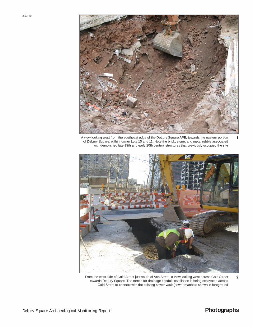
The archaeologist monitoring excavation within former Lots 10 and 11 observed disturbed architectural materials, including large quantities of brick, steel beams, metal sheeting, metal pipes, and glass (see Figure 6, and Figure 7, Photo 1). No in situ brick walls were observed. The disturbed architectural materials appeared to be late 19th or early 20th century in date, based in part on the large quantity of stamped bricks and the hard cementitious nature of the mortar used.
GOLD STREET SIDEWALK AND STREETBED
Excavation within the Gold Street sidewalk and streetbed progressed relatively slowly due to the presence of myriad existing utilities (including gas, telephone, electrical, and water lines). An archaeologist was on-site to monitor excavation of this area for approximately 7 days. Excavation beneath the Gold Street sidewalk extended to approximately 12 feet below ground surface (an area considered sensitive at depths greater than 10 feet below ground surface). The excavation angled downwards to approximately 14 feet below ground surface on the western side of Gold Street (through an area considered sensitive at depths greater than 3 feet below ground surface. Excavation terminated to the west at an existing brick manhole vault near the western curb of Gold Street (see Figure 6 and Figure 7, Photo 2).
Throughout the area monitored in and around the Gold Street sidewalk and streetbed, sub-surface conditions were entirely characterized by late 19th and/or early 20th century architectural demolition debris. Large quantities of red bricks, many stamped (indicating a terminus post quem of the 1880s), predominated the disturbed soils. Yellow bricks with striated sides were also present. Steel I-beams, stone
Table of Contents
7
blocks, electrical wires, and modern tile were also noted. In some cases, modern refuse such as parts of plastic hard-hats was included in the fill; probably associated with previous utility excavation in the late 20th century.
Two in situ features were encountered beneath the street and sidewalk of Gold Street, both relating to the late 19th century buildings that formerly occupied the east side of Gold Street. These included an intact brick foundation wall, and a brick sidewalk vault (see Figures 6 and 8). The brick wall was oriented north-south, roughly perpendicular to the trajectory of Gold Street. Its east edge was located 21 feet west of the existing eastern curb of Gold Street. The disturbed upper portion of the wall was encountered between 3 and 4 feet below ground surface, and the feature extended beyond the depth of excavation approximately 12 feet below ground surface. The lower portion of the wall had a simple brick plinth. The wall was apparently relatively modern, incorporating stamped bricks and hard cementitious mortar. Both the east and west faces of the brick wall were exposed, and a portion of the wall was removed in order to lay the drainage conduit. Based on historic maps presented in the Phase IA for DeLury Square (see, for example, Figure 4), the wall was likely the west foundation wall of the structure that occupied former Lot 15 in the late 19th and 20th centuries.
The remains of a brick vault, likely a sidewalk vault associated with the building that occupied former Lot 15 in the late 19th century, were encountered beneath the streetbed of Gold Street. The largely intact arched ceiling of the vault abutted the brick wall to the east, and extended approximately 9 feet to the west. It was encountered at approximately 3 feet below ground surface. The void beneath the vault was filled with architectural demolition rubble similar in nature to that described above. The vault appeared to have been previously disturbed through the construction of several existing utilities. Sections of the arched ceiling were observed in both the north and south walls of the trench; however, neither walls nor a floor associated with the vault were encountered. Excavation reached a maximum depth of approximately 12 feet below ground surface in this area.
Disturbed soils containing demolition rubble and modern refuse were encountered throughout the remainder of the excavation, which extended roughly 11 feet west of the sidewalk vault to the existing Gold Street sewer described above. This westernmost area of excavation had also been disturbed by several existing utilities (electric, telephone, gas, and water lines).
D. CONCLUSIONS
Archaeological monitoring was conducted in sensitive areas within DeLury Square and Gold Street during excavation for drainage conduits. No archaeological features or artifacts pre-dating the late 19th century were encountered. Sub-surface conditions throughout the affected area were characterized by architectural remnants and demolition debris associated with the late 19th and early 20th century buildings that occupied the block. Remains of a brick wall and arched sidewalk vault were encountered beneath Gold Street. These appear to have been associated with the structure that occupied former Lot 15 during the late 19th century and throughout the first half of the 20th century. The architectural remains encountered during monitoring were not believed to have research potential, but instead belonged to the category of modern disturbance discussed in the Phase IA studies. No further excavation within potentially sensitive areas is planned in the DeLury Square APE or adjacent streetbed as part of the Fulton Street Corridor Improvement Project and no further archaeological monitoring is recommended. The location remains subject to the stipulations of the Unanticipated Discoveries Plan for the Fulton Street Corridor Revitalization Project.

Figures

Delury Square
4.7.
09
SCALE
0 2000 FEET
Project LocationUSGS Jersey City Quandrangle
Figure 1Delury Square Archaeological Monitoring
N
Fulton Street Corridor Project Site
LIBERTY ST.
BRO
ADW
AY
PINE ST.
THAMES ST.
CEDAR ST.
FRO
NT S
T.
FRON
T ST
.
WAT
ER S
T.
WAT
ER S
T. SOUT
H ST
.
PEAR
L ST
.
CEDAR ST.
WIL
LIAM
ST.
NAS
SAU
ST.
NASS
AU S
T.
PLATT ST.
CLIF
F ST
.
JOHN ST.
GO
LD S
T.
MAIDEN LA.
MAIDEN LA.
FLETCHER ST.
CORTLANDT ST.
DEY ST.
FULTON ST.
FULTON ST.
PARK ROW
ANN ST.
THEA
TRE
ALLE
Y
DUTC
H ST
.
SPRUCE ST.
BEEKMAN ST.
BEEKMAN ST.
PARK PL.
BARCLAY ST.
VESEY ST.
FDR
DRIV
E
U.S.
PIE
RHEA
D LI
NE
PEAR
L ST
.
PECK SLIP
FRANKFORT ST.
ROBERT F. WAGNER SR. PL.BROOKLYN BRIDGE APPROACH
4.7.
09
SCALE
0 400 FEET
Project SiteFigure 2Delury Square Archaeological Monitoring
N
Pearl Street Playground APE
Titanic Park APE
Burling Slip APE
Corridor Streetbed APE
DeLury Square APE
Fulton Street Corridor Project Site

4.21
.09
1891 Bromley Map ShowingDeLury Square APE and
Historic Lot NumbersFigure 3Delury Square Archaeological Monitoring
N
His
toric
al P
ersp
ectiv
es In
c. 2
007

18’10’
10’
10’
3’20’
12’
10’
9’16’
11’
FULT
ON
ST.
FULTON ST.
GOLD ST.
ANN ST.
4.20
.09
SCALESCALE
00 2020 50 FEET50 FEET
N
Archaeological SensitivityFigure 4Delury Square Archaeological Monitoring
Delury Square APE
Below 3’
Below 9-10’
Below 11-15’
Below 16-20’
Depth of Archaeological Sensitivity
4.21.09
Proposed Drainage Pipe DepthsFigure 5Delury Square Archaeological Monitoring
N
SCALE
0 20 FEET
Fulton Street Corridor Project Site

18’10’
10’
10’
3’20’
12’
10’
9’ 16’
11’
FULT
ON
ST.
FULTON ST. GOLD ST.
3.23
.10
SCALESCALE
00 2020 50 FEET50 FEET
N
Archaeological Monitoring LocationsFigure 6Delury Square Archaeological Monitoring
1
1
3
4
2
Delury Square APE
Proposed Drainage Pipes Requiring Monitoring
Proposed Drainage Pipes Not Requiring Monitoring
Photo Location
Below 3’
Below 9-10’
Below 11-15’
Below 16-20’
Depth of Archaeological Sensitivity
3.23.10
PhotographsDelury Square Archaeological Monitoring Report
2From the west side of Gold Street just south of Ann Street, a view looking west across Gold Street towards DeLury Square. The trench for drainage conduit installation is being excavated across
Gold Street to connect with the existing sewer vault (sewer manhole shown in foreground
1A view looking west from the southeast edge of the DeLury Square APE, towards the eastern portion of DeLury Square, within former Lots 10 and 11. Note the brick, stone, and metal rubble associated
with demolished late 19th and early 20th century structures that previously occupied the site

3.23.10
PhotographsDelury Square Archaeological Monitoring Report
4The brick arch of the vault shown in Photo 3, looking south from the approximate center of Gold Street, south of Ann Street
3A view of the drainage conduit excavation beneath Gold Street, looking east from the approximate center of Gold Street. The east façade of a brick wall encountered below ground surface is shown on the left. The arched ceiling of a sidewalk vault is visible to the right. These features appeared to be remnants of the building which stood on former Lot 15 in the late 19th and early 20th century