Embed Size (px)
Citation preview

Tectonophysics 710–711 (2017) 108–126
Contents lists available at ScienceDirect
Tectonophysics
j ourna l homepage: www.e lsev ie r .com/ locate / tecto
From stretching to mantle exhumation in a triangular backarc basin(Vavilov basin, Tyrrhenian Sea, Western Mediterranean)
A. Milia a,⁎, M.M. Torrente b, M. Tesauro c
a IAMC, CNR, Calata Porta di Massa, Porto di Napoli, I-80100 Naples, Italyb DST, Università del Sannio, Via dei Mulini 59/A, I-82100 Benevento, Italyc Utrecht University, Budapestlaan, 6, 3584 CD Utrecht, Netherlands
⁎ Corresponding author.E-mail addresses: [email protected] (A. Milia),
(M.M. Torrente), [email protected] (M. Tesauro).
http://dx.doi.org/10.1016/j.tecto.2016.10.0170040-1951/© 2016 Elsevier B.V. All rights reserved.
a b s t r a c t
a r t i c l e i n f oArticle history:Received 29 January 2016Received in revised form 3 October 2016Accepted 18 October 2016Available online 24 October 2016
In this study, we describe the mode of extension of the Vavilov, a fossil backarc basin, triangle-shaped (approx-imately 240 km-wide and 200 km-long), located between Sardinia margin to the west and Campania margin tothe east. We combine the analysis of recent geophysical and geological data, in order to investigate the relation-ship between the crustal/sedimentary structure and the tectonic evolution of both apex and bathyal parts of thebasin.With this aim,we interpret a large data set ofmultichannel seismic reflection profiles and severalwell logs.We observe that the apex basin corresponds to a sediment-balanced basin, with a sedimentary infill recordingthe episodes of basin evolution. In contrast, the distal basin corresponds to an underfilled basin, characterizedby localized volcanic activity and a thin sedimentary succession that covers the exhumed mantle. The basin ar-chitecture reveals the occurrence of rift and supradetachment basins in the Vavilov rift zone. We find that therifting of the Vavilov triangular basin was synchronous from the apex to distal regions around a single Eulerpole located in Latium, between 5.1 and 1.8 Ma. The kinematic evolution of the Vavilov basin occurred in twostages: initial pure shear mode (5.1–4.0 Ma) that produced high-angle normal faults and syn-sedimentarywedges, followed by simple shear mode (4.0–1.8 Ma) that caused supradetachment basins filled by a Transgres-sive-Regressive succession that documents high subsidence rates (1.22mm/y) in the apex region. The final stageof extension in the distal region led to: (i) complete embrittlement of the crust; (ii) direct continuation of crustalfaults to uppermantle depth; (iii) serpentinization andmantle exhumation. Based on constraints on the present-day crustal structure of the Vavilov basin, we obtain a stretching value (β=3.5) and extension rates (3 cm/y) inthe bathyal zone analogous to those reported for magma-poor rifted margins.
© 2016 Elsevier B.V. All rights reserved.
Keywords:Triangular backarc basinsTectono-stratigraphyExtensional modesVavilov basinTyrrhenian Sea
1. Introduction
In recent decades many studies have been carried out on rift forma-tion, in order to understand causes andmodes of whole lithospheric ex-tension (e.g., Coward et al., 1987; Keen, 1987; Ziegler, 1992; Ruppel,1995; Corti et al., 2003; Ziegler and Cloetingh, 2004). Data recordedfrom a large number of extensional regions worldwide indicate thatrifting is a polyphasic process, since rift activity migrates and themode of extension (symmetric to asymmetric pattern) changes throughtime (e.g., Whitmarsh et al., 2001; Reston and Pérez-Gussinyé, 2007;Reston, 2009; Espur et al., 2012; Cloetingh et al., 2013). A critical stepto reconstruct the evolution of a rift zone is the stratigraphic analysisof ancient and active rift basins. This analysis indicates that develop-ment of normal faults, their physiographic expressions, and variationsin fault slip rates are the major factors influencing the spatial
distribution and architecture of depositional systems adjacent to thefault zones (e.g., Dart et al., 1994; Gawthorpe and Leeder, 2000). Exten-sional sedimentary basins can be classified in terms of stratigraphy, ageof formation, basin architecture, and bounding fault's geometry.Friedman and Burbank (1995) proposed that continental extensionaltectonism has two end-members styles: rift settings and highly extend-ed terrains, resulting in high-angle rift basins and supradetachment ba-sins, respectively. The evolution from rift systems to supradetachmentbasins depends on different factors, such as crustal thickness, thermalstate of the lithosphere, and tectonic environment. Temporal changesof these parameters influence the basin structure. In particular,supradetachment basins are characterized by thick or over thickened,recently active lithosphere in a backarc setting (e.g., Coney, 1987).
Extensional basins have been studied and classified using 2Dgeolog-ical sections (e.g., McKenzie, 1978; Bally et al., 1981; Wernicke, 1985;Lister et al., 1986; McClay and Ellis, 1987) and thus also modelled prev-alently in 2D (e.g., Wernicke and Axen, 1988; Whitmarsh et al., 2001;Harris et al., 2002; Corti et al., 2003; Kapp et al., 2008; Brune et al.,2014; Platt et al., 2015). However, the complete process of continental
109A. Milia et al. / Tectonophysics 710–711 (2017) 108–126
break-up can be understood only through detailed 3D studies of riftevolution at varying stretching factors (Reston and Pérez-Gussinyé,2007). Up to now, only few studies use a three-dimensional approachto investigate the evolution of rift basins (Martin, 1984, 2006;Schellart et al., 2003; Lavier and Manatschal, 2006; Sokoutis et al.,2007; Smit et al., 2010).
Natural examples and models have described the modes of exten-sion from stretching to continental break-up and oceanization inmagma-poor rifted margins (e.g., Whitmarsh et al., 2001). Even ifthese types of extension have been observed in the present and fossilAtlantic basins (Manatschal, 2004; Péron-Pinvidic et al., 2007; Espur etal., 2012; Masini et al., 2012), exhumed mantle or hyper-extendedcrust are also typical features of backarc basins (Taylor, 1995), whichcan become parts of orogenic belts (Saintot et al., 2003; Butler et al.,2006; Stephenson et al., 2006; Roure et al., 2012).
According toWhitmarsh et al. (2001), the evolution of a rift area oc-curs with two consecutive modes of continental extension: pure shearand simple shear. The pure shear mode is characterized by high differ-ential subsidence of half-grabens and lithospheric necking. The simpleshear mode is instead characterized by lithospheric detachmentfaulting, strong subsidence, deposition of sub-horizontal strata, andfinal exhumation of serpentinized upper mantle, uprising from adepth b10 km along a downward-concave fault.
Although models of rifts have been largely developed for Atlantictype margins, the Vavilov backarc basin in the Tyrrhenian Sea is theideal place to study different stages of rifting until mantle exhumation.The Tyrrhenian Sea (Fig. 1) is the youngest backarc basin of theWesternMediterranean (e.g., Dewey et al., 1989). Crustal thinning and openingof sedimentary basins in the Tyrrhenian Sea have been documentedsince the start of Deep Sea Drilling Project (DSDP) and Ocean DrillingProgram (ODP) (Hsu et al., 1978; Kastens et al., 1987; Spadini et al.,1995).Within this geological framework, the Vavilov basin representsa perfectly preserved fossil triangular basin, where the extensional pro-cesses reached the mantle exhumation stage during the Pliocene(Mascle and Rehault, 1990; Milia et al., 2013) and moved eastwards inthe Quaternary (Milia and Torrente, 2015a).
In this study, we interpret seismic reflection profiles and wellsdata, in order to reconstruct the architecture and timing of riftingof the Vavilov basin. Our results show rift and supradetachment ba-sins in the Vavilov rift zone and, for the first time, the kinematics ofthe entire triangular basin (from apex to distal zones). Furthermore,we compare the development of the Vavilov basin with two evolu-tionary models of triangular basins: a) the plate tectonic rift model,featuring a synchronous opening across the whole basin, from apexto the distal part around a rotation pole (e.g., Martin, 1984, 2006);b) the propagating rift model, characterized by an extension migra-tion from the distal to the apex of the basin (Lavier andManatschal, 2006). On the basis of this comparison and the crustalstructure of the Vavilov basin, we propose a model of tectonic evolu-tion of the study region.
2. Geologic framework
The Tyrrhenian Sea is a Neogene-Quaternary triangular land-lockedextensional basin that formed at the rear of the Neogene Apenninethrust belt (e.g., Kastens and Mascle, 1990; Patacca et al., 1990). Itsbackarc evolution has mainly been attributed to the rollback towardthe south-east of the subducting Ionian plate (e.g., Malinverno andRyan, 1986, Cavinato and De Celles, 1999; Faccenna et al., 1996;Rosenbaum and Lister, 2004). The central abyssal plain(depth N 3000 m) of the Tyrrhenian Sea is characterized by a thincrust (from 15 to b10 km) and lithosphere (~30 km) (Panza, 1984;Nicolich, 1989; Cassinis et al., 2003), high heat flow values (DellaVedova et al., 2001), and a large positive Bouger gravity anomaly(Mongelli et al., 1975). Rocks of the different geological domains, out-cropping onland and mainly formed during the Alpine orogenic cycle
(e.g., Sartori, 2005), have been dredged in the Tyrrhenian area. Theyrepresent fragments of the European continent (Corsica and Sardinia),Tethyan ophiolites, Calabria crystalline terrane, and Apenninic-Ma-ghrebian chain.
The Tyrrhenian Basin can be divided into northern and southern sec-tors characterized by different extension values. The northernTyrrhenian Sea started to form in the lower Miocene as a polyphaserift, displaying a trend of faults convergent toward the North. Thisbasin has a relatively low value of stretching (e.g., Cornamusini et al.,2002; Pascucci, 2002), constrained by crustal thickness that ranges be-tween 25 and 20 km (Nicolich, 1989). In contrast, the SouthernTyrrhenian Sea (Fig. 1) is a middle Miocene–Quaternary polyphase riftwith several fault trends, which includes the Vavilov basin. Thestretching factor of the Southern Tyrrhenian Sea is relatively high. TheVavilov basin displays a detachment fault cutting the whole crust,which is responsible for the exhumation of serpentinized peridotitesof the mantle (Kastens et al., 1987; Mascle and Rehault, 1990; Milia etal., 2013).
The Vavilov rift zone is flanked in the west by the Cornaglia basinand in the east by the Campania margin (Fig. 1). The Cornaglia basinformed during the upper Miocene on the Sardinia continental margin(e.g., Alvarez et al., 1974; Sartori, 1990, 2003; Spadini et al., 1995;Rosenbaum and Lister, 2004; Milia and Torrente, 2014) and wasdisplaced by high-angle normal faults trending N-S. The associatedsynrift sedimentary wedges correspond to thick Tortonian-Messinianclastic deposits, conformably overlain by thin post-rift early Pliocenedeposits (MPL1; Fig. 1). Different ages for the rifting of the Vavilovbasin have been proposed: upper Tortonian-Messinian (Mascle andRehault, 1990), upper Messinian (Sartori et al., 2004) and lateMessinian-early Pliocene (Sartori, 1990). Extensional processes devel-oped on the Campania margin over the last 1.3 Ma (Torrente et al.,2010;Milia and Torrente, 2015a). The stratigraphy of the Vavilov bathy-al zone is recorded by the ODP sites 655, 651 and DSDP site 373 (Fig. 1).Site 655, located on the crest of the Gortani Ridge, encountered 80 m ofsediments, middle Pliocene (MPL4/NN15)-Quaternary in age, which arelying above and interlayered by MORB basalts (Kastens et al., 1987). AtSite 651 (Kastens et al., 1987) 388 m of marine sediment (MPL6/NN18-Quaternary) overlain 39 m thick of undated dolostones. The basementsection is formed by three units: basalts, transition zone, and highlyserpentinized peridotites, showing a tectonic foliation. The basalts,dated 2.4 Ma (Robin et al., 1987), present carbonate veins, which de-crease downhole, plus carbonate-opal-cemented basaltic breccias. The58 m-thick transition zone comprises two subunits: (i) highly alteredperidotites, dolerites, dolomitic chalk, alkali feldspar-rich leucocraticrocks, carbonate-cemented basaltic breccias, a very coarse sand to finegravel graded layer, and a few rounded loose pebbles of metadolerite.The deepest occurrence of planktonic foraminifers is in a dolomitic brec-cia, tentatively dated early Pliocene; (ii) a lower thin layer of basalts andbasaltic breccias, which could represent tectonic and/or talus breccias,cemented by carbonate sediment filling and carbonate precipitationfrom circulating seawater. At Site 373, 187 m of basaltic breccias andflows, dated 7–4.4 Ma (Savelli and Lipparini, 1978), are covered by a270 m thick Lower Pliocene (MPL3/NN14)-Pleistocene succession(Hsu et al., 1978).
The Latium Apennines fold-and-thrust belt is composed of two tec-tonic units: the Liguride thrust sheet overlying the Carbonate thrustsheet. The Liguride unit, composed of Cretaceous-Miocene clays, marlsand sands, was deposited on oceanic or thinned continental crust andis encountered at depth ranging between ~250 and ~1550 m by on-shore boreholes near Anzio (Fig. 2). The Trias-Miocene Carbonate unitwas deposited on the continental crust of Adria and is composed ofbasal Triassic evaporites (Burano Fm), Jurassic–Eocene carbonate-sili-ceous-marls, Oligocene-Early Miocene marls, clay and arenaceous suc-cession. It oucrops at Circeo Promontory, Zannone Island and Lepiniand is found at depth ranging between ~400 and ~2100 m by onshoreboreholes (Cretaceous-Miocene succession) near Anzio and south of

Fig. 1. (A) Indexmap of Italy and Vavilov basin (green triangle) and location of theM2A CROP profile and DSDP and ODPwell sites. The yellow rectangle indicates the location of the areashown in Fig. 2. Bedrock geology is also included and depicted by colored diamonds and circles (Sartori et al., 2004; Sartori, 2005). (B) Stratigraphic logs of the DSDP and ODP sites,modified from Kastens et al. (1987), using the updated Planktonic foraminifer and calcareous nanofossils integrated biostratigraphic scheme for the Mediterranean Pliocene of Violanti(2012). 1) Pleistocene deposits; 2) Pliocene deposits; 3) dolostones; 4) basalts; 5) Messinian deposits; 6) Tortonian deposits; 7) conglomerates; 8) breccias; 9) serpentinized peridotites.
Fig. 2. Indexmap of seismic grid, ship tracks reported in the text and stratigraphic successions of deepwells from the Latiummargin. AR= Ardea basin, TC= Torre Caldara, L2= Latina2well, L1= Latina1 well, FA= Fiume Astura well, MA=Michelawell, TR= Tre Cancelli well, AC=Acciarella well. FO= Foglianowell. Stratigraphic logsmodified from Lombardi (1968),Malatesta and Zarlenga (1985), Bellotti et al. (1997), ViDEPI (2009). We used the updated Planktonic foraminifer and calcareous nanofossils integrated biostratigraphic scheme (lowerinset) for the Mediterranean Pliocene of Violanti (2012).
110 A. Milia et al. / Tectonophysics 710–711 (2017) 108–126

112 A. Milia et al. / Tectonophysics 710–711 (2017) 108–126
Anzio (Triassic evaporites, Michela well). The Paleozoic metamorphicbasement of the Latium thrust belt, outcropping at Zannone Island, iscovered by the Carbonate unit along a low-angle fault (De Rita et al.,1986), which has been recently interpreted as an extensional detach-ment fault (Milia et al., 2013).
The Latium Apennine fold-and-thrust belt formed during upperMiocene (e.g., Lepini thrust; Fig. 2) and was overprinted in Lower Plio-cene by extensional basins, such as Tiberino, Ardea, and Gaeta Bay ba-sins (Cavinato and De Celles, 1999; Iannace et al., 2013; Milia et al.,2013). The Latium margin includes (Fig. 2) an approximately 100 km-long and 50 km-wide basin extending offshore (Tyrrhenian Sea shelf)and onshore (fromArdea to Pontina Plain). Previous studies of thismar-gin have been based on wells, outcrops and seismic profiles (Malatestaand Zarlenga, 1985, 1986; De Rita et al., 1986; Mariani and Prato, 1988;Faccenna et al., 1994; Bellotti et al., 1997). The basin fill is up to 1500 mthick and formed by thick clastic deposits of Pliocene age, covered by afew hundred meters of Quaternary clastics and tuffs (Lombardi, 1968;Malatesta and Zarlenga, 1985, 1986; Marani et al., 1986; Mariani andPrato, 1988; Bellotti et al., 1997). These deposits, outcropping alongthe coast near Anzio, have been subdivided into four stratigraphicunits (Bellotti et al., 1997). The basal unit corresponds to pelitic andsandy pelitic sediments deposited on a prograding continental shelfduring Lower Pliocene. The palegeographic evolution of the Latiummargin during Pliocene-Pleistocene times is likely controlled by NE–SW, N–S and NW–SE faults (Malatesta and Zarlenga, 1985, 1986;Mariani and Prato, 1988; Faccenna et al., 1994), but the mechanical re-lationship between these faults systems is still debated. The volcanic ac-tivity of the Latium margin started in Pliocene times at the westernPontine Islands (Palmarola, Ponza and Zannone, 4.2 Ma to 1.0 Ma) (DeRita et al., 1986; Cadoux et al., 2005). This acid volcanism was followedin the Middle Pleistocene by the Alban Hills ultrapotassic volcanic com-plex (0.63 to 0.02 Ma) (Scrocca et al., 2003a,b). The Alban Hills are partof the Roman Comagmatic Province (Washington, 1906), a NW-strikingchain of potassic to ultra-potassic volcanic districts that developed alongthe Tyrrhenian coast of Italy since Middle Pleistocene time (Serri, 1990and references therein).
3. Data and methods
We investigated the Vavilov rift zone using 770 km of multichannelseismic profiles (ViDEPI, 2009), well logs acquired in the apex zone (Fig.2), 500 km of CROP seismic profiles (Scrocca et al., 2003b), ODP, andDSDP wells collected in the distal zone (bathyal Tyrrhenian Basin, Fig.1). The seismic interpretation has been calibrated using deep well logsand outcrop data. These seismic data were subsequently processed inorder to obtain a consistent dataset: seismic line basemaps andwell po-sition were geo-referenced in a common coordinate system (EuropeanDatum 50) and assembled in a dedicated GIS environment (Kingdom,IHS Inc.). Raster images of the overall seismic profiles were convertedto segy format using image2segy, a free tool developed by Farran(Instituto de Cièncias del Mar, Barcelona University) for MATLABsoftware.
We interpreted the seismic data-set using the seismic stratigraphymethod (e.g., Mitchum et al., 1977). The seismic units were calibratedusing the lithostratigraphic and offshore/onshore chronostratigraphicdata. The seismic depth conversion in the Vavilov's apex region wasachieved applying the “layer-cake time-depth conversion” model, inwhich the velocity in one layer can potentially be represented by a con-stant, through the “Dynamic Depth Conversion” tool of the 2d/3dPAK-EarthPAK module of the Kingdom software. The values of P-waves ve-locities (Vp) used in the conversion were obtained from the sonic logsof two wells: the Michela well (located offshore) and the Fiume Asturawell (located onshore). The raster image of the sonic logs wereimported, calibrated and then digitalized to obtain, through the use ofspecific algorithms, the velocity log (m/s). We performed a review ofthe stratigraphic units of the Vavilov basin infill present on the
stratigraphic logs (Figs. 1, 2) of the ODP/DSDP projects (Hsu et al.,1978; Kastens et al., 1987; Channell et al., 1990) and Latium margin(Lombardi, 1968; Malatesta and Zarlenga, 1985; Bellotti et al., 1997;ViDEPI, 2009), using an updated Planktonic foraminifer and calcareousnannofossils integrated biostratigraphic scheme for the MediterraneanPliocene (Violanti, 2012). We interpreted faults on seismic reflectionprofiles, mapped them in a GIS environment, and displayed them aslines on structure contour maps and isochron maps. Although in theapex zone many boundary faults displacing the substrate are buriedby thick Pliocene deposits, the high density of seismic linesmade it pos-sible to recognize and linkmajor faults based on their geometry, dip di-rection, and amount of throw. In contrast, in the distal rift zone,characterized by few seismic profiles and underfilled basins, the map-ping of the main faults down-throwing the substrate was supportedby swath bathymetry data (Marani et al., 2004).
4. Results
4.1. Basin physiography
Themain physiographic feature of the Vavilov basin is the triangulargeometry of its 3500 m-deep bathyal plain convergent toward the La-tium margin (Fig. 1). The margins of the bathyal plain correspond tostructural highs made up of metamorphic and sedimentary rocksbounded by NE-SW and NW-SE faults (e.g. Selli Line., Sartori Escarp-ment). NNE-trending large volcanic seamounts (Magnaghi, Vavilov) oc-cupy the otherwise flat-lying abyssal plain. The Latium margin ischaracterized by an approximately 20 km-wide continental shelf thatis connected to the bathyal plain by a region characterized by an irreg-ular physiography and intra-slope basins (Fig. 1). The onshore Latiummargin is formed by a wide plain bounded by the reliefs of the Apen-nines (Fig. 2). Its structural pattern features Pliocene-Quaternary nor-mal faults trending NE-SW (Ardea basin) and NW-SE (Pontina Plain)that converge into the apex located at the Alban Hills volcano (Fig. 2).
4.2. Apex stratigraphy and basin geometry
The stratigraphy of the apex zone, documented by several deepwells and outcrops, is characterized by a Pliocene-Pleistocene succes-sion that lies unconformably on a variable substrate, corresponding tothe Apennine nappes made up of Mesozoic-Miocene carbonate rocksof shelf and margin environment, overthrusted by Mesozoic-Mioceneclastic rocks of deep basin environment (Liguride unit) (Fig. 2). On thebasis of the planctonic foraminifera, Pliocene deposits have been attrib-uted to the MPL2-MPL6 biostratigraphic zones (Fig. 2). The oldest Plio-cene stratigraphic units (MPL2-MPL3) outcrop in the western part ofthe study area (Ardea basin and Torre Caldara sections; Fig. 2). A thickand younger succession, mainly composed of MPL4 deposits, was en-countered in the central part of the study area (Latina 1, Fiume Astura,Martina, Tre Cancelli and Acciarella wells). Notably, in the eastern partof the study area an unconformity separating MPL4 deposits fromMPL6 deposits has been recognized (Fogliano well).
The interpretation of the seismic lines, calibrated by wells and out-crops in the apex region, allowed the recognition of a Pliocene-Quater-nary succession overlying the acoustic substrate and reconstruction ofthe architecture of the sedimentary basins and faults. The first step ofthe seismic interpretationwas the identification of seismic stratigraphicunits. Individual units were delineated on the basis of stratal termina-tion, lower and upper boundary and internal layering features revealedby seismic reflectivity. The acoustic substrate (Unit L) is characterizedby a chaotic seismic facies and bounded at the top by strong reflectorsin the western and central parts of the basin; its upper boundary is ir-regular and disrupted by faults (Figs. 3a, 4). Unit L corresponds to theCretaceous-Miocene clastic deposits of the Liguride nappeoverthrusting the Mesozoic carbonate nappe, as documented by wellsstratigraphy (Fig. 2) and onshore geology. In the central basin, Unit L

Fig. 3. Close-ups of seismic profiles sectors showing seismic facies types, diagnostic key horizons of the acoustic substrate, and Pliocene-Pleistocene basin fill. For seismic lines location seeFig. 4.
113A. Milia et al. / Tectonophysics 710–711 (2017) 108–126
overlays Unit T, characterized by transparent seismic facies. The latterunit presents strong reflectors at the top displaying a convex-upwardsgeometry (Fig. 3a). The stratigraphy of the Michela well (Fig. 2) revealsthat the underlying unit corresponds to Triassic evaporites (Burano Fm)that are the lowermost part of the Apennine carbonate succession, tec-tonically overlain by the Liguride unit (Fig. 3a). In the eastern part of theLatiumMargin, the acoustic substrate (UnitMZ; Fig. 3b) is characterizedby isolated strong reflectors with approximately parallel geometry. Itstop features a continuous strong reflector with high amplitude andlow frequency. This substrate corresponds to Mesozoic-Cenozoic rockscropping out onshore (e.g. Lepini Mts, Circeo Promontory) and drilledin wells Latina 2 and Fogliano (Fig. 2). In the offshore north of ZannoneIsland, the acoustic substrate presents a chaotic seismic facies and corre-sponds to the Paleozoic metamorphic basement rocks (Fig. 4c) outcrop-ping on the island and covered by tectonic slices of Mesozoic-Cenozoicrocks (De Rita et al., 1986).
The acoustic substrate is covered in onlap or downlap by a seismicunit characterized by parallel or subparallel reflectors with variable am-plitude and frequency and having good continuity (Fig. 3c). This youn-ger seismic unit corresponds to the Pliocene-Quaternary succession
drilled offshore and onshore. The occurrence of angular and erosionalunconformities permitted us to recognize several subunits (Fig. 4). In-deed, the well calibration based on foraminifera biozones and stratigra-phy of the outcropping geologic section allowed us to divide thePliocene-Quaternary succession into subunits MPL2–3, MPL4, MPL5,MPL6, and Quaternary (Fig. 4).
In the northwestern area an asymmetrical rift basin filled by the Pli-ocene-Quaternary succession is present (Fig. 4a–b). The rift basin fea-tures NW-dipping and SE-dipping normal faults. This western basin,corresponding to the prolongation of the onshore Ardea basin, displaysa thick (up to1 second TWTT) lower Pliocene (MPL2-MPL4) infill, fea-turing a SE-wards thickening of the wedge that records syn-tectonicfault activity. The western basin develops as a graben bounded by syn-thetic and antithetic faults near the coast. Seawards its depocenter isshifted and its architecture changes to a half-graben delimited by NW-dipping faults and filled by a clastic wedge (Fig. 4a–b).
In contrast, in the central area a larger and deep sedimentary basinoccurs (Fig. 4a–b). The infill of the central basin displays relics of olderMPL2-MPL3 sediments,which overlieminor fault blocks and are toppedby an erosional truncation. Thick sub-horizontal MPL4 deposits fill the

Fig. 4. (A) Interpreted seismic line 101 and its calibration with drilled boreholes located near the profile. (B) Interpreted seismic line 109 calibrated with the Michela well. (C) Interpreted seismic line 111 (modified after Milia et al., 2013). Dottedorange and white boxes delimit the close-ups displayed in Fig. 3.
114A.M
iliaetal./Tectonophysics
710–711(2017)
108–126

115A. Milia et al. / Tectonophysics 710–711 (2017) 108–126
basin onlapping older deposits and the substrate. The top of MPL4deposits corresponds to an erosional unconformity. Southwardsthe central basin displays (Fig. 4c) the MPL4 succession that onlapsthe Paleozoic metamorphic basement (outcropping at Zannone Is-land) and both units are covered by MPL6 deposits. The centralbasin depocenter is shifted in correspondence of a transform fault(Fig. 4c).
Thewells drilled in the axial part of the basin reveal the stratigraphicfeatures of the thickMPL4 succession in the central basin from proximalto distal environments going seawards (Figs. 2, 5). All well logs show afining-upward trend and a general Transgressive-Regressive cycle ofthe overall succession, suggesting a subsidence of the basin compensat-ed by sediment supply (Fig. 5). In particular, the Michela well records a1090 m-thick Transgressive-Regressive cycle deposited over 0.86 Maand thus a basin subsidence rate of 1.22 mm/y. This value of subsidence
Fig. 5.Geophysical and lithological logs of threewells collected along the axis of the central basincharacteristic spontaneous potential (SP), lithological log (L) and resistivity (R) signatures for fiMPL4 deposits in the Vavilov apex zone. The Maximum Flooding Surface is recognized based ocombination with facies analysis. FA = Fiume Asturia, TR = Tre Cancelli, MA= Michela.
rate of the apex region of the Vavilov basin is high compared to the typ-ical synrift subsidence rates (b0.2 mm/y) of stretched basin (Allen andAllen, 2005). In particular, in the proximal area, a relatively thick succes-sion of Transgressive sands overlies basal conglomerates and passesgradually upward to a silts/clays succession. Seaward this successionpasses to a thick silts/clays succession with interlayered sand levelsthat repose on a stratum of sands. The distal deposits correspond tosilts and clays interlayered with sands. The trend of the facies and thegamma ray/resistivity logs permit to identify the maximum floodingsurface that represents the maximum deepening that the basin experi-enced. This surface is covered by a coarsening-upward succession, re-cording a general Regressive trend of the facies. The age of the MPL4foraminiferal biozone ranges between 4.04 and 3.18 Ma (Violanti,2012). During this time span a third order depositional sequenceformed (Za2 sequence of Snedden and Liu, 2010).
fromproximal to distal areas (see Fig. 2 for the location of thewell). The log pattern showsning upwards (Trangressive cycle) and coarsening upwards (Regressive cycle) units of then observed discontinuities or changes in trend of the signature of wireline log records in

116 A. Milia et al. / Tectonophysics 710–711 (2017) 108–126
The tectonic omission of the Jurassic-Cretaceous carbonate nappe intheMichelawell (that drilled the tectonic contact between Liguride unitand Triassic evaporites) and the occurrence of Mesozoic carbonate tec-tonic slices above the Paleozoic basement at Zannone Island can beinterpreted as the occurrence of an extensional detachment surface inthe apex region. Indeed, in regions of high extension, crustal blocks ofthe upper plate are separated (e.g. Hamilton, 1987). We hypothesizethe occurrence of a detachment fault between an upper plate,made up of Ligure unit overlying the Jurassic-Cretaceous carbonatenappe, and a lower plate formed by the Triassic evaporites overlyingthe Paleozoic crystalline basement. With increasing extension theonce continuous carbonate nappe was fragmented into tectoniclenses that slid apart along this detachment. In the last stage, theflat geometry of the detachment was bowed upward and theexhumation of the Paleozoic basement occurred. According to thedetachment model, we maintain that the high-angle normal faultsbounding the central basin merge into a main listric normal faultdipping SE into the Triassic evaporites (Fig. 4). Due to the highimpedance contrast between Triassic evaporitic rocks and clasticdeposits of the Liguride unit, a strong sub-horizontal reflector(Fig. 3a) is associated with this low-angle fault that displays abowed upward geometry, (Fig. 4a–b).
The architecture of the central basin (sub-horizontal strata of thebasin fill, N20 km-wide) in the apex area supports its interpretation asa supradetachment basin that formed above a low-angle normal faultsystem and shows a depocenter located approximately 10 km awayfrom the main bounding fault (Fig. 4).
In the eastern margin (Pontina Plain), there is another half-grabenbasin filled by two Pliocene sedimentarywedges (MPL4 andMPL6, sep-arated by a tectonically-enhanced unconformity) and a Quaternary tab-ular unit (Fig. 6). This basin is controlled by NW-oriented normal faultsand shows a main fault located at the boundary between coastal plainand Lepini Mountains (Fig. 2).
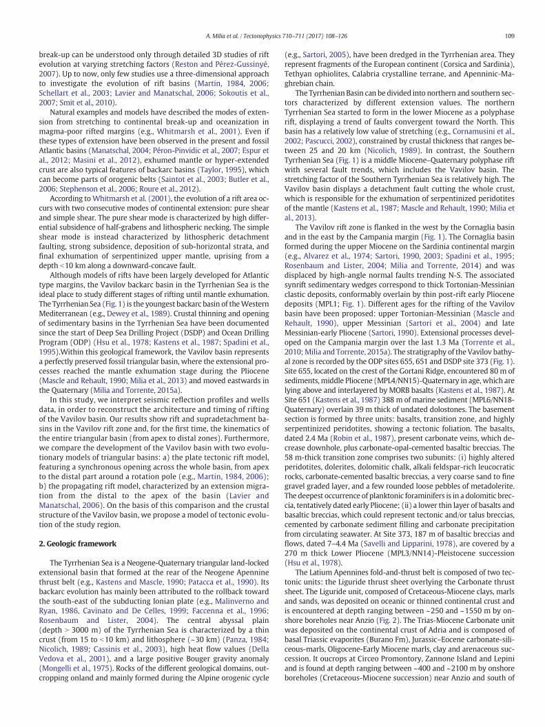
In order to obtain an isopachmap of Pliocene-Quaternary deposits inthe Vavilov's apex region, we made a depth conversion of the seismicdata. We found the arithmetic average of the P-waves velocities valuesfor the main lithostratigraphic units drilled by the Michela and FiumeAstura wells (Fig. 7). Based on the mean values of P-waves velocities(Vp) obtained from well Sonic Logs, a four-layers velocity model hasbeen adopted for the seismic depth conversion: Vp values of 1500 m/s,2700 m/s, 3487 m/s and 6138 m/s were assigned to sea water, Plio-cene-Quaternary deposits, Liguride Unit and Burano Anidrites, respec-tively. The structural isopach map (Fig. 8) displays a triangular riftarea with three main depocentres: a western basin (approximately10 km-wide and up to 2000 m-thick), a central basin (approximately20 km-wide and up to-2400 m-thick), and an eastern basin (PontinaPlain, up to 1000 m-thick). The fault pattern is characterized by normalfaults, transfer faults and inversion structures (sensu Cooper andWilliams, 1989). The normal faults trend from ENE-WSW to N-S toNW-SE and converge toward a rotation pole located in correspondenceof Alban Hills volcano.
Fig. 6. Interpreted seismic line across the Pontina Plain, calibrated with the stratigraphic log onormal faults (modified from Milia and Torrente, 2015a). This basin is overprinted on the Ape
4.3. Fault timing in the apex zone
On the basis of the geometry and age of the basin infill, we dated sev-eral events of fault activity: (i) the oldest normal faults were active be-tween 5.1 and 4.5 Ma (MPL2-MPL3 succession); (ii) younger normalfaults affected the central basin between 4.0 and 3.2 Ma (MPL4 succes-sion); (iii) the normal faults that bound the eastern basin were activeuntil 1.8 Ma (MPL6 succession). The displacement along these normalfaults is transferred, or relayed, from one to the next along accommoda-tion zones corresponding to transfer faults. Accommodation zonesalongmajor bounding structures are sites of intra-basinal highs, charac-terized by thinner sedimentary covers (Fig. 9). The transfer faults, or-thogonal to the normal faults, offset the basin depocenters (Fig. 8). Apositive inversion structure located near a transfer fault deforms thecentral basin rift. Indeed the thick MPL4 deposits, bounded by N-S nor-mal faults, are shortened to form an antiform, overlying sub-horizontalstrata. These observations suggest that some of the pre-existing faultsare successively inverted (Fig. 10). The transfer faults formed duringthe extensional phases and were reactivated after the deposition ofthe MPL4 deposits. The age of this inversion tectonics can be correlatedto the stratigraphic gap (betweenMPL4 andMPL6) in the Fogliano wellsuccession (Fig. 2) that in turn can be interpreted as a tectonically-en-hanced unconformity.
4.4. Distal stratigraphy and basin geometry
The Vavilov rift zone (Fig. 11) shows a converging pattern of normalfaults bounding submarine ridges, from west to east: (i) the NE-SWCentral Fault (Selli Line), bordering the western part of the bathyalbasin; (ii) the NNE-SSW De Marchi seamount, consisting of an exten-sional allochthon composed of Tethyan ophiolitic rocks, parallel to acouple of normal faults controlling a Pliocene-Pleistocene depocenter(thickness N 1 km); (iii) the N-S Gortani ridge, composed of basalticrocks, bounding the largest depocenter of Pliocene-Quaternary deposits(thickness N 1 km) in the central bathyal area; (iv) a NW trending ridge,separating the bathyal zone from the eastern Tyrrhenian continentalmargin.
Several studies of the Tyrrhenian Sea described the stratigraphy andmain structural features of this basin. However, the interpretation of theCROP seismic data, calibrated byODPwells and dredges, provides a newpicture of the Tyrrhenian rifting, characterized by a complex basin ar-chitecture (Fig. 12). The identification of the sedimentary basin fill andsubstrate permitted us to attribute an age to the basin formation. EarlyPliocene sediments (MPL1) were deposited west of the De MarchiSmt. In the Cornaglia basin the MPL1 unit forms an isopach postriftlayer that overlies in stratigraphic continuity thick upper Miocenesynrift sedimentary wedges. Between the Central Fault and the DeMarchi Smt a younger basin, bounded by normal faults displacing Plio-cene deposits, shows in the middle (ODP site 656) the MPL2 unit over-lying Messinian deposits. East of the De Marchi Smt instead youngerPliocene deposits (MPL4-MPL6) fill the central bathyal plain.
f the Fogliano well, showing a Pliocene-Quaternary basin bounded by SW-dipping listricnnine thrust belt formed by Mesozoic-Cenozoic rocks. For seismic line location see Fig. 2.

Fig. 7. Lithological and sonic logs of Michela and Fiume Astura wells (see Fig. 2 for well location). The right panel displays a statistical analysis of the velocities of the Pliocene-Quaternarydeposits, Liguride Unit and Burano Anidrites.
117A. Milia et al. / Tectonophysics 710–711 (2017) 108–126
Even if it is not possible to detect strong reflectors in the deeper partof the CROP seismic profiles, we have evidence of the basal extensionaldetachment in the bathyal zone from the drilling of the ODP 651 site(Fig. 12). On the basis of this tectonic constraint, we propose an inter-pretation of the extensional fault system and a crustal geological
model of the Vavilov basin characterized by: high-angle normal faultslinked to a basal detachment, rift, and supradetachment basins (Fig.12). More in detail, the overall fault pattern of the Vavilov distal regionis characterized by two sets of structures (Fig. 12): older faults, mainlyformed west of the De Marchi Seamount and younger faults, active
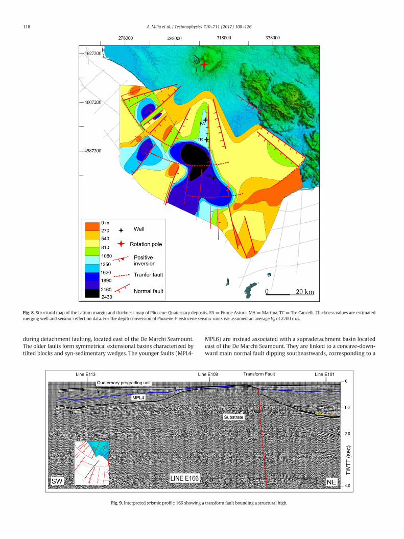
Fig. 8. Structural map of the Latium margin and thickness map of Pliocene-Quaternary deposits. FA = Fiume Astura, MA = Martina, TC = Tre Cancelli. Thickness values are estimatedmerging well and seismic reflection data. For the depth conversion of Pliocene-Pleistocene seismic units we assumed an average Vp of 2700 m/s.
118 A. Milia et al. / Tectonophysics 710–711 (2017) 108–126
during detachment faulting, located east of the De Marchi Seamount.The older faults form symmetrical extensional basins characterized bytilted blocks and syn-sedimentary wedges. The younger faults (MPL4-
Fig. 9. Interpreted seismic profile 166 showing a
MPL6) are instead associated with a supradetachment basin locatedeast of the De Marchi Seamount. They are linked to a concave-down-ward main normal fault dipping southeastwards, corresponding to a
transform fault bounding a structural high.

Fig. 10. Interpreted seismic profile 170 displaying a positive inversion structure.
119A. Milia et al. / Tectonophysics 710–711 (2017) 108–126
detachment surface (drilled at site 651) that displaced the entire crustand upper mantle, and led to the exhumation of serpentinized perido-tites. East of the De Marchi Seamount, a central bathyal plain (drilled
Fig. 11. Pattern of normal faults and thickness map of Pliocene-Pleistocene deposits displayiSeamount, G = Gortani Ridge. Thicknesses of the distal region are from Sartori et al. (2004eastwards time migration of extension in the Vavilov basin.
at sites 655, 651, and 373) is located. This area is characterized by theabsence of major topographic highs, except for the volcanic reliefs ofthe Gortani ridge and Vavilov volcano (Fig. 1).
ng the triangular geometry of the Vavilov rift zone; CF = Central Fault, D = De Marchi) and seafloor morphology is from Marani et al. (2004). The lower diagrams show the
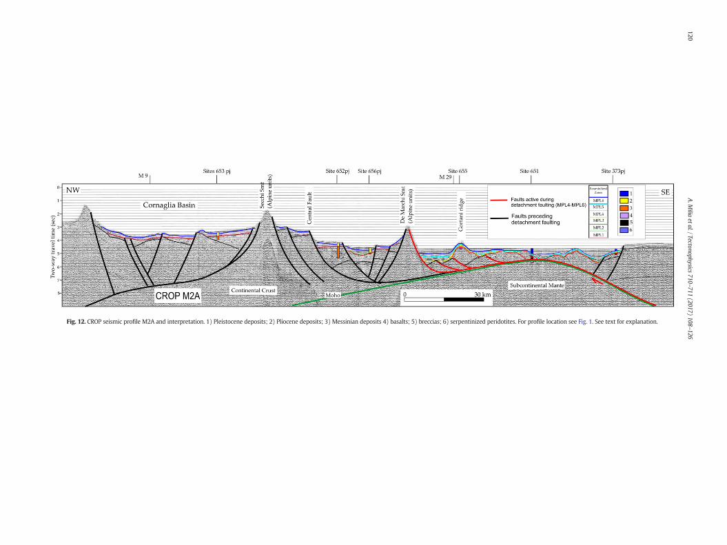
Fig. 12. CROP seismic profile M2A and interpretation. 1) Pleistocene deposits; 2) Pliocene deposits; 3) Messinian deposits 4) basalts; 5) breccias; 6) serpentinized peridotites. For profile location see Fig. 1. See text for explanation.
120A.M
iliaetal./Tectonophysics
710–711(2017)
108–126

121A. Milia et al. / Tectonophysics 710–711 (2017) 108–126
5. Discussion
Here we use seismic stratigraphic and structural methods to inter-pret the basin architecture and evolution. Indeed, the age, distributionand pattern of the sedimentary infill is strictly controlled by the devel-opment of the normal faults. The variety of structural geometries andtheir effect on the sedimentation and evolution of the sedimentary fillhave been used to interpret the main structural elements at depth.The interpretation of the data discussed in the previous section in aframework provided by the European crustal model EuCRUST-07(Tesauro et al., 2008), enables us to analyze the link existing betweenthe crustal structure and basin evolution. In this way, we obtain a com-plete picture of the tectonic evolution of the region, lacking so far.
5.1. Kinematic evolution
We propose a kinematic model for the Pliocene Tyrrhenian rift de-velopment based on the premise that age and architecture of the sedi-mentary basins and faults bounding the basins provide snapshots of aregional continuous extensional process (Figs. 13–14). The wedge-shaped Miocene deposits of the western area of the Tyrrhenian Sea re-cord the opening of the N-S elongated Cornaglia Basin (Sartori et al.,2004). They are covered by Early Pliocene (MPL1) postrift deposits,which are absent in the apex region (Apennines) and distal area eastof the De Marchi Smt. The Vavilov rifting, started in the Lower Pliocene(MPL2–3), produced a system of graben/half graben bounded by highangle normal faults that displaced the Latium margin and the distalarea west of the De Marchi Seamount. These basins were affected
Fig. 13. Cartoon (not scaled) showing three-stage kinematics
by continuous subsidence and, in the area close to the coast, werefilled by thick clastic deposits. With increasing extension, the devel-opment of low-angle normal faults resulted in the formation of newsedimentary basins filled by a middle Pliocene (MPL4) sedimentarysuccession. The activity of detachment zones is documented by thedeposition of basin-wide horizontal strata in both apex and distalareas.
A kinematic evolution of the rift zone characterized by rift basinsfollowed by supradetachment basins is compatible with the Present ge-ometry of the thrust belt in the apex region. Indeed, the original thrustbelt architecture of the Apennine preceding the extensional processeswas made up of Liguride nappe overlying Carbonate nappe (Fig. 13a).Successively, the rifting process affected these stacked tectonic unitswith high-angle normal faults that root downward into the Triassicevaporites (Fig. 13b). We suggest that with the increase of extension,these high-angle faults linked and merged into a basal low-angle de-tachment, whose activity produced the Carbonate Nappe lateral seg-mentation and the direct superposition of the Liguride unit above theTriassic evaporites (Fig. 13c). This stage records the formation of asupradetachment basin, showing sub-horizontal strata developed incorrespondence of the detachment fault that roots in the Triassic evap-orites. Progressive lithospheric extension resulted in thinning of theupper crust, as the detachment fault affected the Palaeozoic metamor-phic basement, which was bowed upward (Fig. 13d). At this time afast uplift occurred, probably due to isostatic adjustments. A similar ki-nematic style (rift basins followed by supradetachment basins) hasbeen proposed for the upperMiocene evolution of the Paleo-TyrrhenianSea (Milia and Torrente, 2015b).
of the apex rift region. See text for further explanations.

Fig. 14. Interpretative sketch (not scaled) displaying envisaged evolution of the Vavilov rift zone.
122 A. Milia et al. / Tectonophysics 710–711 (2017) 108–126
The study of the basin fill geometry and fault architecture from apexto distal zones enables us to construct a 3D kinematic model for theVavilov triangular basin that links extension and volcanism (Fig. 14).The convergent pattern of normal faults (Fig. 11) is coherent with a sin-gle Euler pole, located in Latium, during the entire basin history. The ki-nematics of the Vavilov region records the complete evolution of a riftfrom stretching to mantle exhumation and the development of rift ba-sins, followed by supradetachment basins (Fig. 14). During theMessinian-early Pliocene (7.0–5.1 Ma; Fig. 14a), MPL1 postrift sedi-ments were deposited at the top of upper Miocene syndepositionalwedges only in the distal region on the Sardinia margin. Basaltic volca-nism started in the bathyal plain at DSDP site 373.
The age of the sedimentary infill documents that the Vavilov basinstarted to open in the Lower Pliocene (5.1–4.0 Ma; Fig. 14b) coherentlyfrom the apex to distal regions by a pure shear mode, characterized bydistributed high-angle normal faulting and asymmetric/symmetric riftbasins displaying MPL2-MPL3 syn-kinematic wedges. We maintainthat rifting lasted 5.1–4 Ma and thereafter a detachment basin evolvedfrom 4 to 1.8 Ma. The extension switched during the upper Pliocene(Fig. 14c) to a simple shear mode, associated to detachment faults. Asupradetachement basin formed in the apex rift zone, which is character-ized by strong subsidence and thick sub-horizontalMPL4 deposits featur-ing a Transgressive-Regressive cycle. In contrast, thin deposits are presentin the basin distal zone, due to the increase of the distance from the sed-iment source area (Apennines). In the distal zone the extension produceda tectonic breccia (site 651), including clasts of deformed early Pliocenedeposits and serpentinized peridotites, indicating that the detachmentfault cut the upper mantle. During this stage two basaltic volcanoesformed: the Magnaghi seamounts and the Gortani ridge.
The final stage of opening of the Vavilov basin developed by a simpleshear mode in the Upper Pliocene (3.2–1.8 Ma) when MPL5-MPL6 de-posits were laid down (Fig. 14d). The activity of detachments causedthe maximum thinning and exhumation of serpentinized peridotitesof the mantle in the distal zone and metamorphic basement rocks inthe proximal one. The bowed upwards detachment geometry in theapex area suggests a rapid uplift of crustal rocks that can be explainedby isostatic adjustments. Similarly, in theVavilov distal zone the detach-ment fault that exhumed mantle rocks displays a downward concavegeometry. A downward concave geometry of detachment faults hasbeen predicted in magma-poor extensional margins by numerical ex-periments and constrained by geological and geophysical observations(Whitmarsh et al., 2001). In particular, the model of Lavier andManatschal (2006) demonstrates that (1) the flow of the middle partof the crust in the initial stage of rifting and (2) serpentinization of theupper mantle during its last exhumation phase, are the two processesthat likely weaken the lithosphere and can explain the rifting evolution,with the establishment of a concave-downward fault. The volcanic ac-tivity during the final stage of opening of the Vavilov basin was charac-terized by small patches of lavas (flood basalts), erupted directly ontothe exhumed detachment surfaces. This scenario ofMORB basalts, over-lying detachment faults and dykes intrusions, is typical of magma-poorrifted margins, as observed in the Indian Ocean (Sauter et al., 2013).
5.2. Crustal structure of the Vavilov basin and geodynamical implications
The heterogeneous crustal structure of the Vavilov basin is shown bythe two cross-sections derived from EuCRUST-07 (Fig. 15). This modelwas constructed assembling a significant number of seismic data

123A. Milia et al. / Tectonophysics 710–711 (2017) 108–126
provided by refraction, reflection, and receiver function studies. It pro-vides the depth of the main crustal boundaries and velocities of theupper and lower crust on a uniform grid 15'×15' (Tesauro et al.,2008). We can observe that in the apex region of the basin the crusthas a thickness of 20–25 km and two crustal layers with distinct seismicvelocities typical of extended continental crust (cross-section 1; Fig. 15).The crust thins and decreases its average velocity toward the bathyalpart of the basin quite abruptly (N10 km and ~0.3 km/s over a horizon-tal distance of b100 km). The thinning occurs approximately in corre-spondence of the updoming and exhumation of the Paleozoicmetamorphic basement (Fig. 4c), which is likely an effect of isostatic ad-justment, as a consequence to the decrease of crustal thickness. Thecrust in the bathyal region of the basin is quite homogeneous (cross-section 2, Fig. 15), being characterized by a uniform thickness of~7 km and low seismic velocities (Vp ~ 6 km/s) compared to deeperserpentinised peridotite. These results agree with recent seismic refrac-tion interpretation (Prada et al., 2014). The increase of crustal thicknessand average velocity toward the Sardinian and Calabrian margin ismuch smoother (~10 km and 0.3 km/s over a horizontal distance of~150 km) than toward the apex of the basin. Such a difference in thecrustal thickness variations can be ascribed to a change in the crustalstrength during the rifting. The higher extension rate in the centralpart of the basin has caused larger temperature in this area than in theapex during the opening phase. Consequently, the crustal brittle-ductiletransition has migrated at shallower depth in the bathyal region, as ob-served from the faults pattern (Fig. 11). Therefore, the thinning of thebrittle part of the crust in this area is responsible for the smoother tran-sition of the crustal thickness.
Fig. 15.Moho depth of the Tyrrhenian Sea and surroundings according to the crustal model EuC07, displaying the crustal thickness and P-wave velocity variations in the Vavilov basin. Sedimeseismic reflection profiles. Pn values are from Cassinis et al. (2003).
Assuming an average crustal thickness preceding the formation ofthe Vavilov basin of ~35 km and mean values of the crustal thicknessof ~22 kmand ~10 km in the apex and bathyal region the correspondingstretching factor β is ~1.5 and ~3.5, respectively. This difference in thestretching value has significant implications on the crustal type flooringthe Vavilov basin. In the northern part of the basin, the limited exten-sion could only modestly thin the continental crust. In contrast, thestronger extension affecting the southern part of the basin could haveled to full continental break-up with the consequent formation of oce-anic crust, as sustained by some studies (Kastens and Mascle, 1990;Mascle and Rehault, 1990; Sartori, 1990, 2003; Marani and Trua, 2002;Nicolosi et al., 2006) or may have onlymodified the original continentalcrust in a transitional type (Panza and Calcagnile, 1979/1980; Florio etal., 2011; Milia et al., 2013; Prada et al., 2014). The low crustal seismicvelocities in the bathyal region can be representative of either continen-tal or oceanic rocks, aswell as serpentinized peridotite (Christensen andMooney, 1995). Therefore, these data alone cannot uniquely identify thecrustal type characterizing this area, but can be helpful in supportinghypotheses on its crustal nature.
Combining different geophysical data, Prada et al. (2014)interpreted the low crustal velocity as due to the serpentinized uppermantle, locally intruded by basalts. However, they did not detect theboundaries between the extended continental crust and exhumedupper mantle, neither make hypotheses on the time and cause of theupper mantle exhumation. We suggest that the final stage of openingof the Vavilov basin was characterized by the activity of a detachment,maximum thinning and exhumation of serpentinized peridotites ofthemantle, simple shearmode (sensuWhitmarsh et al., 2001), covered
RUST-07 (Tesauro et al., 2008). Red lines depict location of two cross-sections of EuCRUST-ntary thickness and P-wave velocity variations are derived from the interpretation of the

124 A. Milia et al. / Tectonophysics 710–711 (2017) 108–126
by basalts 2.4 Ma old andMPL6 deposits. On the basis of the interpreta-tion of the CROP seismic lines (Fig. 12), we propose that the mantlerocks have been exhumed along a downward concave fault plane. Asimilar geometry is common in magma-poor extensional margins, asdemonstrated by numerical experiments (Whitmarsh et al., 2001;Lavier and Manatschal, 2006). These models support the formation ofexhumed upper mantle during the final stage of continental extension.Mantle serpentinization occurs during margin formation when seawa-ter comes in contact with cold lithospheric mantle rocks (b600 °C).This can occur during extension when the crust is progressively cooled.At this stage, crustal scale faulting becomes possible and can provide thepathways for seawater to reach and react with cold mantle rocks, caus-ing their serpentinization. According to some studies (Hauser et al.,1995; O'Reilly et al., 2006; Reston and Pérez-Gussinyé, 2007), embrittle-ment of the crust (and thus water ingress and serpentinization) is fa-vored when the upper and middle crust is more extended than thelower crust and upper mantle. Where the upper part of the crust is ex-tended more than its lower part, its heat production will be strongly at-tenuated, leading to a reduction in lower crustal temperatures andgreater likelihood of embrittlement. Such a difference in the stretchingvalue of the crust has been invoked to explain the formation of a mod-erately serpentinized (b25%) upper mantle, beneath the Porcurpineand the Southern Rockall basins of the North Atlantic margin (Hauseret al., 1995; O'Reilly et al., 2006).
The peridotite sampled at the Site 651 has been subjected to differ-ent episodes of hydrous metasomatism/metamorphism. The first oneoccurred at relatively high temperatures (N700 °C) at the depth of theupper mantle and was likely induced by the fluids released by thesubducting Ionian plate. The successive episodes of hydrousmetasoma-tismoccurred at crustal levels, at progressively lower pressure and tem-peratures, during the ascent of the peridotite (Bonatti et al., 1990).Uplift of the peridotite body is also supported by its sequence of high-temperature foliation-low-temperature foliation-brittle deformation(Bonatti et al., 1990). The current prevalence of low-temperature hy-drated silicates, such as lizardite and chrysotile, and the scarcity ofantigorite suggests that the highest degree of serpentinization wasvery likely caused by seawater circulating at shallow crustal depth at atemperature not higher than a few hundred degree (Bonatti et al.,1990). Therefore, differently from other extensional basins (e.g., in thePorcurpine and the Southern Rockall basins), where the serpentinizedperidotite constitutes a high velocity layer (Vp N 7.2 km/s) underlyingthe crust at a depth of ~10 km (Hauser et al., 1995; O'Reilly et al.,2006), in the Vavilov basin the upper mantle is exhumed at muchshallower depth and almost exposed at the seafloor at the site 651(Fig. 12). Thus, the extension in the bathyal region of the Vavilov basincaused a more significant crustal thinning and the exhumation of amore serpentinized upper mantle than in the magma-poor continentalmargins. On the basis of the low seismic velocities observed(Vp ~ 6.0 km/s, Fig. 15), we can estimate that the peridotite reached anaverage degree of serpentinization around 50%–60% (Christensen,2004). Exhumation of the upper mantle at very shallow depth and itspervasive serpentinization has been observed in magma poor riftedmargins (e.g., Iberian plain) during the last stage of continental exten-sion preceding Oceanization (Chian et al., 1999; Whitmarsh et al.,2001). In contrast, the magmatic activity in the Vavilov basin, leadingtoflood basalts emplacement over the exhumed uppermantle, followedby the formation of the Vavilov volcano, was not sufficiently volumi-nous for the formation of real oceanic crust. The crystalline crust floor-ing the bathyal region of the Vavilov basin is instead a transitionaltype, composed of serpentinized upper mantle, overlain by volcanicproducts and thin continental crust west of the De Marchi seamount(Fig. 12). This heterogeneous crust is seismically uniform, characterizedby the absence of intra-crustal discontinuities (Fig. 15). Oceanic crustformation could have likely occurred only if extension had persisted inthe same area, as in the Iberian plain (Chian et al., 1999; Whitmarsh etal., 2001) or would have been faster. Actually, serpentinites are also
typical of abyssal plains surrounding slow spreading ridges (b5 cm/y),which are characterized only by episodic magmatic activity. In contrast,the fast spreading ridges (N9 cm/y) are characterized by a more signif-icant magmatic activity, which leads to the formation of a thick oceaniccrust (Deschamps et al., 2013).
The maximum extension of the Vavilov basin occurred in a circa100 km-wide belt of the bathyal area, bounded by a NE-SW normalfault locatedwest the DeMarchi seamount and a N-S normal fault locat-ed near the 373 site. The substrate of this belt corresponds to exhumedmantle andnot continental crust, thus implying a total amount of exten-sion in the Vavilov rift of 100 km. Because the Vavilov basin formed in3.3 Ma this gives a mean extension rate of 3 cm/y, similar to the valuespreviously reported for the entire southern Tyrrhenian. These low ex-tension rates and the occurrence of serpentinized mantle are typical ofslow (b5 cm/y) seafloor spreading margins. Several kinematic recon-structions (Malinverno and Ryan, 1986; Faccenna et al., 2001;Malinverno, 2012) pointed to a total amount of extension in the south-ern Tyrrhenian region ranging between 330 and 390 km. This gives anaverage extension rate of 3.3–3.9 cm/y, in view of the start of theTyrrhenian rifting 10 Ma ago.
6. Conclusions
We combined the analysis of seismic reflection profiles, boreholedata, and the crustalmodel EuCRUST-07 (Tesauro et al., 2008), to recon-struct the 3D architecture and evolution of the triangular Vavilovbackarc basin from apex to distal areas. From the results obtained weconclude that:
1. On the basis of age and sedimentary facies of the basin infill we esti-mate a Pliocene timing (5.1–1.8 Ma) of the rift zone formation.
2. Initial pure shear mode extension, characterized by distributedhigh-angle normal faulting and rift basins, was followed by simpleshear mode extension, associated to detachment faults andsupradetachment basins.
3. The growth of detachment faults started 4.0Ma ago affected contem-poraneously the entire basin and involves structural levels progres-sively deeper down to the mantle.
4. Embrittlement of the crust and through-going faults formation intothe upper mantle have led to serpentization andmantle exhumationalong a downward concave detachment plane in the distal region.The downward concave fault geometry can be associated to rollinghinge and isostatic adjustments.
5. The seismologicalMoho identified at a depth of ~10 kmdoes not cor-respond to the petrological Moho, at least in the southeastern part ofthe basin, where the serpentinized upper mantle is exhumed at adepth ~500 m from the surface topography (ODP site 651). This in-terpretation implies also that continental crust in the bathyal regionhas been locally thinned and extendedmore significantly than previ-ously estimated.
6. The opening of this triangular backarc basin occurred around anEuler pole and was geologically synchronous from the apex to thedistal zones.
Acknowledgements
This study was funded by Universita'del Sannio (FRA 2015), UtrechtUniversity, and the Netherlands Research Centre for Integrated SolidEarth Science (ISES) (ISES-2014-UU-08, ISES-2016-UUU-19). Wethank IHS Inc. that furnished the Kingdom software. We are gratefulto KeithMartin for the very detailed reviewandhighly stimulating com-ments. Further comments provided by an anonymous reviewer are alsoacknowledged. We thank S. Cloetingh for his suggestions on an earlierversion of the manuscript.

125A. Milia et al. / Tectonophysics 710–711 (2017) 108–126
References
Allen, P.A., Allen, J.R., 2005. Basin analysis. Principles and Applications, 2nd edition Black-well Publishing (549 pp).
Alvarez, W., Cocozza, T., Wezel, F.C., 1974. Fragmentation of the Alpine orogenic belt bymicroplate dispersal. Nature 248, 309–314.
Bally, A.W., Bernoulli, D., Davis, G.A., Montadert, L., 1981. Listric normal faults. Oceanol.Acta 26, 87–101.
Bellotti, P., Evangelista, S., Tortora, P., Valeri, P., 1997. Caratteri sedimentologici estratigrafici dei sedimenti pliopleistocenici affioranti lungo la costa tra Tor Caldara eAnzio (Lazio centrale). Boll. Soc. Geol. Ital. 116, 79–94.
Bonatti, E., Seyler, M., Channell, J., Giraudeau, J., Mascle, G., 1990. Peridotite drilledfrom the Tyrrhenian Sea, ODP LEG 107. In: Kastens, K.A., Mascle, J., et al. (Eds.),1990 Proceedings of the Ocean Drilling Program. Scientific Results 107,pp. 37–47.
Brune, S., Heine, C., Pérez-Gussinyé, M., Sobolev, S.V., 2014. Rift migration explains conti-nental margin asymmetry and crustal hyper-extension. Nat. Commun. 5:1–9. http://dx.doi.org/10.1038/ncomms5014.
Butler, R.W.H., Tavarnelli, E., Grasso,M., 2006. Structural inheritance inmountain belts: anAlpine–Apennine perspective. J. Struct. Geol. 28, 1893–1908.
Cadoux, A., Pinti, D., Aznar, C., Chiesa, S., Gillot, P.Y., 2005. New chronological and geo-chemical constraints on the genesis and geologic evolution of Ponza and PalmarolaVolcanic Islands (Thyrrenian Sea, Italy). Lithos 81, 121–151.
Cassinis, R., Scarascia, S., Lozej, A., 2003. The deep crustal structure of Italy and surround-ing areas from seismic refraction data. A new synthesis. Boll. Soc. Geol. It. 122,365–376.
Cavinato, G.P., De Celles, P.G., 1999. Extensional basins in the tectonically bimodal centralAppennines fold-thrust belt, Italy: response to corner flow above a sub-ducting slabin retrograde motion. Geology 27, 955–958.
Channell, J.E.T., Rio, D., Sprovieri, R., Glaçon, G., 1990. Biomagnetostratigraphic correla-tions from Leg 107 in the Tyrrhenian Sea. In: Kastens, K.A., Mascle, J., et al. (Eds.), Pro-ceedings of the Ocean Drilling ProgramScientific Results 107. Ocean Drilling Program,College Station, TX, pp. 669–682.
Chian, D., Louden, K.F., Minshull, T.,Whitmarsh, R., 1999. Deep structure of the ocean-con-tinent transition in the southern Iberian Abyssal Plain from seismic refraction pro-files: Ocean Drilling Program (Legs 149 and 173) transect. J. Geophys. Res. 104(B4), 7443–7462.
Christensen, N.I., 2004. Serpentinites, peridotites, and seismology. Int. Geol. Rev. 46 (9):795–816. http://dx.doi.org/10.2747/0020-6814.46.9.795.
Christensen, N.I., Mooney, W.D., 1995. Seismic velocity structure and composition of thecontinental crust: a global view. J. Geophys. Res. 100 (B7), 9761–9788.
Cloetingh, S., Burov, E., Matenco, L., Beekman, F., Roure, F., Ziegler, P.A., 2013. TheMoho inextensional tectonic settings: insights from thermo-mechanical models.Tectonophysics 609, 558–604.
Coney, P.J., 1987. The regional tectonic setting and possible causes of Cenozoic extensionin the North American Cordigliera. In: Coward, M., Dewey, J., Hancock, P. (Eds.), Con-tinental Extensional Tectonics. Geol. Soc. Spec. Publ 28, pp. 177–186.
Cooper, M.A., Williams, G.D. (Eds.), 1989. Inversion tectonicsGeol. Soc. Lond., Spec. Publ.44.
Cornamusini, G., Lazzarotto, A., Merlini, S., Pascucci, V., 2002. Eocene-Miocene evolutionof the north Tyrrhenian Sea. Boll. Soc. Geol. Ital. 1, 769–787.
Corti, G., VanWijk, J., Bonini, M., Sokoutis, D., Cloetingh, S., Innocenti, F., Manetti, P., 2003.Transition from continental break-up to punctiform seafloor spreading: how fast,symmetric and magmatic. Geophys. Res. Lett. 30 (12):1604. http://dx.doi.org/10.1029/2003GL017374.
Coward, M., Dewey, J., Hancock, P. (Eds.), 1987. Continental Extensional Tectonics. Geol.Soc. Spec. Publ 28 (637 pp).
Dart, C.J., Collier, R.E.L., Gawthorp, R.L., Keller, J.V., Nichols, G., 1994. Sequence stratigraphyof (?) Pliocene–Quaternary syn-rift Gilbert type deltas, northern Peloponnesos,Greece. Mar. Pet. Geol. 11, 545–560.
De Rita, D., Funiciello, R., Pantosti, D., Salvini, F., Sposato, A., Velonà, M., 1986. Geologicaland structural characteristics of the Pontine islands (Italy) and implications withthe evolution of the Tyrrhenian margin. Mem. Soc. Geol. Ital. 36, 55–65.
Della Vedova, B., Bellani, S., Pellis, G., Squarci, P., 2001. Deep temperatures and surfaceheat flow distribution. In: Vai, G.B., Martini, I.P. (Eds.), Anatomy of an Orogen: TheApennines and Adjacent Mediterranean Basins. Kluwer Academic Publishers, Dor-drecht, The Netherlands, pp. 65–76.
Deschamps, F., Godard, M., Guillot, S., Hattori, K., 2013. Geochemistry of subduction zoneserpentinites: a review. Lithos 178, 96–127.
Dewey, J.F., Helman, M.L., Turco, E., Hutton, D.H.W., Knott, S.D., 1989. Kinematics of theWestern Mediterranean. In: Coward, M.P., Dietrich, D., Park, R.G. (Eds.), Alpine Tec-tonics 45. Geol. Soc. London Spec. Pub, pp. 225–283.
Espur, N., Callot, J., Roure, F., Totterdell, J.M., Struckmeyer, H.I.M., Vially, R., 2012. Transi-tion from symmetry to asymmetry during continental rifting: an example from theBight Basin–Terre Adélie (Australian and Antarctic conjugate margins). Terra Nova24:167–180. http://dx.doi.org/10.1111/j.1365-3121.2011.01055.x.
Faccenna, C., Funiciello, R., Bruni, A., Mattei, M., Sagnotti, L., 1994. Evolution of a transfer-related basin: the Ardea basin (Latium, Central Italy). Basin Res. 6, 31–46.
Faccenna, C., Davy, P., Brun, J.P., Funiciello, R., Giardini, D., Mattei, M., Nalpas, T., 1996. Thedynamic of backarc basins: an experimental approach to the opening of theTyrrhenian Sea. Geophys. J. Int. 126, 781–795.
Faccenna, C., Becker, T.W., Lucente, F.P., Jolivet, L., 2001. History of subduction and back-arc extension in the Central Mediterranean. Geophys. J. Int. 145, 809–820.
Florio, G., Fedi, M., Cella, F., 2011. Insights on the spreading of the Tyrrhenian Sea from themagnetic anomaly pattern. Terra Nova 23:127–133. http://dx.doi.org/10.1111/j.1365-3121.2011.00992.x.
Friedman, S.J., Burbank, D.W., 1995. Rift basins and supradetachment basins:Intracontinental extensional end-members. Basin Res. 7, 109–127.
Gawthorpe, R.L., Leeder, M.R., 2000. Tectono-sedimentary evolution of active extensionalbasins. Basin Res. 12, 195–218.
Hamilton, W., 1987. Crustal extension in the Basin and Range Province, southwesternUnited States. In: Coward, M.P., Dewey, J.F., Hancock, P.L. (Eds.), Continental Exten-sional Tectonics 28. Geol. Soc. London Spec. Pub, pp. 155–176.
Harris, L.B., Koy, H.K., Fossen, H., 2002. Mechanisms for folding of high-grade rocks in ex-tensional tectonic settings. Earth-Sci. Rev. 59, 163–210.
Hauser, F., O'Reilly, B.M., Jacob, A.W.B., Shannon, P.M., Makris, J., Vogt, U., 1995. The crustalstructure of the Rockall trough: differential stretching without underplating.J. Geophys. Res. 100:4097–4116. http://dx.doi.org/10.1029/94jb02879.
Hsu, et al., 1978. Site 373: Tyrrhenian Basin. Deep Sea Drilling Project Volume XLII Part 1,pp. 151–174.
Iannace, P., Milia, A., Torrente, M.M., 2013. 4D geologic evolution in the GaetaBaysedimentary infill (Eastern Tyrrhenian Sea). GeoActa 12, 25–36 (Bologna).
Kapp, P., Taylor, M., Stokling, D., Ding, L., 2008. Development of active low-angle normalfault systems during orogenic collapse: insight from Tibet. Geology 36:7–10. http://dx.doi.org/10.1130/G24054A.1.
Kastens, K., Mascle, J., 1990. The geological evolution of the Tyrrhenian Sea: an introduc-tion to the scientific results of ODP Leg 107. In: Kastens, K.A., Mascle, J., et al. (Eds.),Proc. ODP, SciResults 107. Ocean Drilling Program, College Station, TX, pp. 3–26.
Kastens, K.A., et al., 1987. Proceedings ODP, Initial. Reports 107. Ocean Drilling Program,College Station, TX (999 pp).
Keen, C.E., 1987. Some important consequences of lithospheric extension. In: Coward,M.P., Dewey, J.F., Hancock, P.L. (Eds.), Continental Extensional Tectonics. GeologicalSociety, London, Special Publications 28, pp. 67–73.
Lavier, L.L., Manatschal, G., 2006. A mechanism to thin the continental lithosphere atmagma-poor margins. Nature 440:324–328. http://dx.doi.org/10.1038/nature04608.
Lister, G.S., Etheridge, M.A., Symonds, P.A., 1986. Application of the detachment faultmodel to the formation of passive continental margins. Geology 14, 246–250.
Lombardi, L., 1968. Il pozzo Fogliano nei pressi di Latina e la palegeografia dell'area. Boll.Soc. Geol. Ital. 87, 13–18.
Malatesta, A., Zarlenga, F., 1985. Il Quaternario di Pomezia (Roma) e la sua fauna marina.Boll. Soc. Geol. Ital. 104, 503–514.
Malatesta, A., Zarlenga, F., 1986. Evoluzione paleogeografico-strutturale Plio-Pleistocenicadel basso bacino romano a nord e a sud del Tevere. Mem. Soc. Geol. It. 35, 75–85.
Malinverno, A., Ryan, W.B.F., 1986. Extension in the Tyrrhenian Sea and shortening in theApennines as result of arc migration driven by sinking of the lithosphere. Tectonics 5,227–245.
Malinverno, A., 2012. Evolution of the Tyrrhenian Sea-Calabrian Arc system: The past andthe present. Rend. Online Soc. Geol. It. 21, 11–15.
Manatschal, G., 2004. Newmodels for evolution ofmagma-poor riftedmargins based on areview of data and concepts from West Iberia and the Alps. Int. J. Earth Sci. 93,432–466.
Marani, M., Trua, T., 2002. Thermal constriction and slab tearing at the origin of asuperinflated spreading ridge: Marsili volcano (Tyrrhenian Sea). J. Geophys. Res.107 (B9):2188. http://dx.doi.org/10.1029/2001jb000285.
Marani, M., Taviani, M., Trincardi, F., Argnani, A., Borsetti, A., Zitellini, N., 1986. Pleistoceneprogradation and post-glacial events of the NE Tyrrhenian continental shelf betweenthe Tiber delta and Capo Circeo. Mem. Soc. Geol. Ital. 36, 67–89.
Marani, M., Gamberi, G., Bortoluzzi, G., Carrarra, G., Ligi, M., Penitenti, D., 2004. Seafloormorphology of the Tyrrhenian Sea. Scale 1:1,000,000. Included to: Mem. Descr.Carta Geol. Ital., LXIV. Rome.
Mariani, M., Prato, R., 1988. I bacini neogenici costieri del margine tirrenico: approcciosismico-stratigrafico. Mem. Soc. Geol. Ital. 41, 519–531.
Martin, A.K., 1984. Propagating rifts: crustal extension during continental rifting. Tecton-ics 3, 611–617.
Martin, A.K., 2006. Oppositely directed pairs of propagating rifts in backarc basins: doublesaloon door seafloor spreading during subduction rollback. Tectonics 25, TC3008.http://dx.doi.org/10.1029/2005TC001885.
Mascle, J., Rehault, J.-P., 1990. A revised seismic stratigraphy of the Tyrrhenian Sea: impli-cations for the basin evolution. In: Kastens, K.A., Mascle, J., et al. (Eds.), Proceedings ofthe Ocean Drilling Program, Scientific Results, 107. Ocean Drilling Program, CollegeStation, TX, pp. 617–634.
Masini, E., Manatschal, G., Mohn, G., Unternehr, P., 2012. Anatomy and tectono-sedimen-tary evolution of a rift-related detachment system: the example of the Err detach-ment (Central Alps, SE Switzerland). Geol. Soc. Am. Bull. 124, 1535–1551.
McClay, K.R., Ellis, P.G., 1987. Analogue models of extensional fault geometries. In:Coward, M., Dewey, J., Hancock, P. (Eds.), Continental Extensional Tectonics. Geol.Soc. Spec. Publ 28, pp. 109–125.
McKenzie, D.P., 1978. Some remarks on the development of sedimentary basins. EarthPlanet. Sci. Lett. 40, 25–32.
Milia, A., Torrente, M.M., 2014. Early-stage rifting of the southern Tyrrhenian region: theCalabria-Sardinia breakup. J. Geodyn. 81:17–29. http://dx.doi.org/10.1016/j.jog.2014.06.001.
Milia, A., Torrente, M.M., 2015a. Tectono-stratigraphic signature of a rapidmultistage sub-siding rift basin in the Tyrrhenian-Apennine hinge zone (Italy): a possible interactionof upper plate with subducting slab. J. Geodyn. 86:42–60. http://dx.doi.org/10.1016/j.jog.2015.02.005.
Milia, A., Torrente, M.M., 2015b. Rift and supradetachment basins during extension: in-sight from Tyrrhenian rift. J. Geol. Soc. 72:5–8. http://dx.doi.org/10.1144/jgs2014-046.
Milia, A., Torrente, M.M., Massa, B., Iannace, P., 2013. Progressive changes in rifting direc-tions in the Campania margin (Italy): new constrains for the Tyrrhenian Sea opening.Glob. Planet. Chang. 109:3–17. http://dx.doi.org/10.1016/j.gloplacha.2013.07.003.

126 A. Milia et al. / Tectonophysics 710–711 (2017) 108–126
Mitchum, R.M., Vail, P.R., Sangree, J.B., 1977. Seismic stratigraphy and global changes ofsea level, part 6: stratigraphic interpretation of seismic reflection patterns in deposi-tional sequences. In: Payton, C.E. (Ed.), Seismic Stratigraphy – Application to Hydro-carbon Exploration. Am. Ass. Petr. Geol. Mem 26, pp. 117–133.
Mongelli, F., Loddo, M., Calcagnile, G., 1975. Some observations of the Apennines gravityfield. Earth Planet. Sci. Lett. 24, 385–393.
Nicolich, R., 1989. Crustal structure from seismic studies in the frame of the EuropeanGeotraverse (Southern segment) and CROP project. In: Boriani, A., Bonafede, M.,Piccardo, G.B., Vai, G.B. (Eds.), The Lithosphere in Italy. Advances in Earth Science Re-search. Atti Convegni dei Lincei 80, pp. 41–61.
Nicolosi, I., Speranza, F., Chiappini, M., 2006. Ultrafast oceanic spreading of the MarsiliBasin, southern Tyrrhenian Sea: evidence from magnetic anomaly analysis. Geology34, 717–720.
O'Reilly, B.M., Hauser, F., Ravaut, C., Shannon, P.M., Readman, P.W., 2006. Crustal thinning,mantle exhumation and serpentinization in the Porcupine Basin, offshore Ireland: ev-idence from wide-angle seismic data. J. Geol. Soc. 163:775–787. http://dx.doi.org/10.1144/0016-76492005-079.
Panza, G.F., 1984. Structure of the lithosphere–asthenosphere system in the Mediterra-nean region. Ann. Geophys. 2, 137–138.
Panza, G., Calcagnile, G., 1979/1980. The upper mantle structure in Balearic andTyrrhenian bathyal plains and the Messinian salinity crisis. Palaeogeogr.Palaeoclimatol. Palaeoecol. 29, 3–14.
Pascucci, V., 2002. Tyrrhenian Sea extension north of the Elba Island between Corsica andwestern Tuscany (Italy). Boll. Soc. Geol. Ital. 1, 819–828.
Patacca, E., Sartori, R., Scandone, P., 1990. Tyrrhenian basin and Apenninic arcs: kinematicrelations since late Tortonian times. Mem. Soc. Geol. Ital. 45, 425–451.
Péron-Pinvidic, G., Manatschal, G., Minshull, T.A., Sawyer, D.S., 2007. Tectonosedimentaryevolution of the deep Iberia-Newfoundlandmargins: evidence for a complex breakuphistory. Tectonics 26, TC2011. http://dx.doi.org/10.1029/2006TC001970.
Platt, J.P., Behr, W.M., Cooper, F.J., 2015. Metamorphic core complexes: windows into themechanics and rheology of the crust. J. Geol. Soc. 172:9–27. http://dx.doi.org/10.1144/jgs2014-036.
Prada, M., Sallares, V., Ranero, C.R., Vendrell, M.G., Grevemeyer, I., Zitellini, N., de Franco,R., 2014. The complex 3-D transition from continental crust to backarc magmatismand exhumed mantle in the Central Tyrrhenian basin. Geophys. J. Int. 203 (2015):63–78. http://dx.doi.org/10.1093/gji/ggv271.
Reston, T.J., 2009. The structure, evolution and symmetry of the magma-poor rifted mar-gins of the North and Central Atlantic: a synthesis. Tectonophysics 468, 6–27.
Reston, T.J., Pérez-Gussinyé, M., 2007. Lithospheric extension from rifting to continentalbreakup at magma-poor margins: rheology, serpentinisation and symmetry. IntJ. Earth Sci. (Geol Rundsch) 96:1033–1046. http://dx.doi.org/10.1007/s00531-006-0161-z.
Robin, C., Colantoni, P., Genessaux, M., Rehault, J.P., 1987. Vavilov seamount: a midly alka-line Quaternary volcano in the Tyrrhenian basin. Mar. Geol. 78, 125–136.
Rosenbaum, G., Lister, G.S., 2004. Neogene and Quaternary rollback evolution of theTyrrhenian Sea, the Apennines, and the Sicilian Maghrebides. Tectonics 23, TC1013.http://dx.doi.org/10.1029/2003TC001518.
Roure, F., Casero, P., Addoum, B., 2012. Alpine inversion of the North African margin anddelamination of its continental lithosphere. Tectonics 31. http://dx.doi.org/10.1029/2011TC002989 (TCXXX).
Ruppel, C., 1995. Extensional processes in continental lithosphere. J. Geophys. Res. 100,187–215.
Saintot, A., Stephenson, R., Brem, A., Stovba, S., Privalov, V., 2003. Paleostress field recon-struction and revised tectonic history of the Donbas fold-and-thrust belt (Ukraineand Russia). Tectonics 22, 1059.
Sartori, R., 1990. The main results of ODP Leg 107 in the frame of neogene to recent geol-ogy of Perityrrhenian areas. In: Kastens, K.A., Mascle, J., et al. (Eds.), Proceedings ofthe Ocean Drilling ProgramScientific Results 107. Ocean Drilling Program, CollegeStation, TX, pp. 715–730.
Sartori, R., 2003. The Tyrrhenian back-arc basin and subduction of the Ionian lithosphere.Episodes 26 (3), 217–221.
Sartori, R., 2005. Bedrock geology of the Tyrrhenian Sea insight on Alpine paleogeographyandmagmatic evolution of the basin. In: Finetti, I.R. (Ed.), CROP Project: Deep SeismicExploration of the Central Mediterranean and Italy. Elsevier, Amsterdam, pp. 69–80.
Sartori, R., Torelli, L., Zitellini, N., Carrara, G., Magaldi, M., Mussoni, P., 2004. Crustal fea-tures along a W-E Tyrrhenian transect from Sardinia to Campania margins (CentralMediterranean). Tectonophysics 383, 171–192.
Sauter, D., et al., 2013. Continuous exhumation of mantle-derived rocks at the southwestIndian Ridge for 11 million years. Nat. Geosci. 6:314–320. http://dx.doi.org/10.1038/NGEO1771.
Savelli, C., Lipparini, E., 1978. K/Ar age determinations on basalt rocks from hole 373 A.Deep Sea Drilling Project Volume XLII Part 1, pp. 537–539.
Schellart, W.P., Jessell, M.W., Lister, G.S., 2003. Asymmetric deformation in the backarc re-gion of the Kuril arc, northwest Pacific: new insights from analogue modeling. Tec-tonics 22:1047. http://dx.doi.org/10.1029/2002TC001473.
Scrocca, D., Doglioni, C., Innocenti, F., 2003a. Constraints for an interpretation of the Italiangeodynamics: a review. Mem. Descr. Carta Geol. Ital. 62, 15–46.
Scrocca, D., Doglioni, C., Innocenti, F., Manetti, P., Mazzotti, A., Bertelli, L., Burbi, L., D'Offizi,S., 2003b. Crop atlas seismic reflection profiles on the Italian crust. Mem. Descritt.Carta Geol. Ital. 62, 1–193 (36 plates enclosed).
Serri, G., 1990. Neogene–quaternary magmatism of the Tyrrhenian region: characteriza-tion of magma sources and geodynamic implications. Mem. Soc. Geol. Ital. 41,219–242.
Smit, J., Brun, J.-P., Cloetingh, S., Ben-Avraham, Z., 2010. The rift-like structure and asym-metry of the Dead Sea Fault. Earth Planet. Sci. Lett. 290, 74–82.
Snedden, J.W., Liu, C.L., 2010. A Compilation of Phanerozoic Sea-level Change, CoastalOnlaps and Recommended Sequence Designations. Search and Discovery, Article#40594.
Sokoutis, D., Corti, G., Bonini, M., Brun, J.P., Cloetingh, S., Mauduit, T., Manetti, P., 2007.Modelling the extension of heterogeneous hot lithosphere. Tectonophysics 444,63–79.
Spadini, G., Cloetingh, S., Bertotti, G., 1995. Thermo-mechanical modelling of theTyrrhenian Sea: lithosphere necking and kinematics of rifting. Tectonics 14, 629–644.
Stephenson, R., Yegorova, T., Brunet, M.-F., Stovba, S., Wilson, M., Starostenko, V., Saintot,A., Kusznir, N., 2006. Late Palaeozoic intra- and pericratonic basins on the East Euro-pean Craton and its margins. In: Gee, D.G., Stephenson, R.A. (Eds.), European Litho-sphere Dynamics 32. Geol. Soc. of London, Mem., pp. 463–479.
Taylor, B. (Ed.), 1995. Backarc Basins. Tectonics and Magmatism. Plenum Press (524pp).Tesauro, M., Kaban, M.K., Cloetingh, S.A.P.L., 2008. EuCRUST-07: a new reference model
for the European crust. Geophys. Res. Lett. 35, L05313. http://dx.doi.org/10.1029/2007GL032244.
Torrente, M.M., Milia, A., Bellucci, F., Rolandi, G., 2010. Extensional tectonics in the Cam-pania Volcanic Zone (eastern Tyrrhenian Sea, Italy): new insights into relationshipbetween faulting and ignimbrite eruptions. Ital. J. Geosci. 129:297–315. http://dx.doi.org/10.3301/IJG.2010.07.
ViDEPI, 2009. Progetto Visibilità Dati Esplorazione Petrolifera in Italia. © 2009–2010Ministero dello Sviluppo Economico UNMIG, Soci-età Geologica ItalianaAssomineraria (last accessed on 25.11.11, http://unmig.sviluppoeconomico.gov.it/videpi/).
Violanti, D., 2012. Pliocene Mediterranean foraminiferal biostratigraphy: a synthesis andapplication to the paleoenvironmental evolution of northwestern Italy. In: Elitok, Ö.(Ed.), Stratigraphic Analysis of Layered Deposits, pp. 123–160 (ISBN: 978-953-51-0578-7, InTech).
Washington, H.S., 1906. The Roman Comagmatic Region. vol. 57. Carnegie Institute,Washington, pp. 1–199.
Wernicke, B.P., 1985. Uniform-sense normal simple shear of the continental lithosphere.Can. J. Earth Sci. 22, 108–124.
Wernicke, B.P., Axen, G.J., 1988. On the role of isostasy on the evolution of normal faultsystems. Geology 16, 848–851.
Whitmarsh, R.B., Manatschal, G., Minshull, T.A., 2001. Evolution of magma-poor continen-tal margins from rifting to seafloor spreading. Nature 413, 150–154.
Ziegler, P.A., 1992. Plate tectonics, plate moving mechanisms and rifting. Tectonophysics215, 9–34.
Ziegler, P.A., Cloetingh, S., 2004. Dynamic processes controlling evolution of rifted basins.Earth Sci. Rev. 64, 1–50.