Embed Size (px)
Citation preview

From GPS and Google Maps to Spatial Computing
December 2016
Shashi Shekhar McKnight Distinguished University Professor Department of Computer Science and Eng.
University of Minnesota www.cs.umn.edu/~shekhar

Outline
• Introduction – Spatial Computing Audience: Niche => Everyone – Spatial Computing 2020 - Workshop
• GPS • Location Based Services • Spatial Statistics • Spatial Database Management Systems • Virtual Globes & Remote Sensing • Geographic Information Systems • Conclusions
2

What is Spatial Computing?
• Transformed our lives though understanding spaces and places • Ex.: localization, navigation, site selection, precision agriculture, … • Examples: spatial context, situation assessment (distribution, patterns), …
Smarter Planet

The Changing World of Spatial Computing
Last Century Last Decade
Map User Well-trained few Billions
Mappers Well-trained few Billions
Software, Hardware
Few layers, e.g., Applications: Arc/GIS, Databases: SQL3/OGIS
Almost all layers
User Expectations & Risks
Modest Many use-case & Geo-privacy concerns

It is widely used by Government!
Geospatial Information and Geographic Information Systems (GIS): An Overview for Congress
5
May 18th, 2011
Folger, Peter. Geospatial Information and Geographic Information Systems (GIS): Current Issues and Future Challenges. Congressional Research Service. June 8th, 2009.

6
It is only a start! Bigger Opportunities Ahead!
7
7
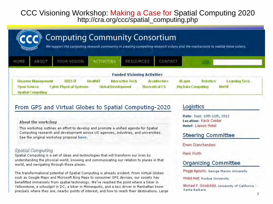
CCC Visioning Workshop: Making a Case for Spatial Computing 2020 http://cra.org/ccc/spatial_computing.php

Workshop Highlights
8
Organizing Committee Agenda • Identify fundamental research questions
for individual computing disciplines • Identify cross-cutting research questions
requiring novel, multi-disciplinary solutions

9
2012 CCC Workshop: Spatial Computing Visioning
• Ten Opportunities
1. Spatial Abilities Predict STEM Success 2. Emerging Spatial Big Data 3. Augmented Reality Systems 4. Time-Travel in Virtual Globes 5. Spatial Predictive Analytics 6. Persistent Environment Hazard Monitoring 7. Geo-collaborative Systems, Fleets, and Crowds 8. Localizing Cyber Entities 9. GPS Deprived Environment 10. Beyond Geo

Outline
• Introduction • GPS
– Outdoors => Indoors • Location Based Services • Spatial Statistics • Spatial Database Management Systems • Virtual Globes & Remote Sensing • Geographic Information Systems • Conclusions
10

Global Positioning Systems (GPS)
• Positioning ships – Latitude f(compass, star positions) – Longitude Prize (1714) => marine chronometer – accuracy in nautical miles
• Global Navigation Satellite Systems
– Use: Positioning, Clock synchronization – Infrastructure: satellites, ground stations, receivers, …
Trilateration
http://answers.oreilly.com/topic/2815-how-devices-gather-location-information/
http://en.wikipedia.org/wiki/Global_Positioning_System

Positioning Precision
12

Trends: Localization Indoors and Underground
• GPS works outdoors, but, – We are indoors 80% of time! – Ex. malls, hospitals, airports, …
• Leveraging existing indoor infrastructure
– Blue Tooth, Wi-Fi, …
• How to represent indoors space?

14
Trends: Localizing Cyber Entities, e.g., tweets, pictures, …
Even before cable news outlets began reporting the tornadoes that ripped through Texas on Tuesday, a map of the state began blinking red on a screen in the Red Cross' new social media monitoring center, alerting weather watchers that something was happening in the hard-hit area. (AP, April 16th, 2012)

Outline
• Introduction • GPS • Location Based Services
– Queries => Persistent Monitoring • Spatial Statistics • Spatial Database Management Systems • Virtual Globes & Remote Sensing • Geographic Information Systems • Conclusions
15

Location Based Services
• Location: Where am I? (street address, <latitude, longitude>) • Directory:
– What is around me? – Where is the nearest clinic (or ambulance)?
• Routes: What is the shortest path to reach there?
16

17
Traditional SBD: Spatial Graphs • Spatial Graph Examples
– Roadmaps, rail-road networks, air-routes – Electric grid, Gas pipelines, supply chains, …
• Graph data sub-genre – Nodes, Edges, Routes, … – Flow networks with capacity constraints
• Use cases: – Geo-code, Map-matching, … – Connectivity, Shortest paths, … – Travel-time based nearest store, hospital, … – Logistics, supply-chain management, …
Graph Data for UMN Campus Courtesy: Bing

Dynamic Nature of Transportation Network
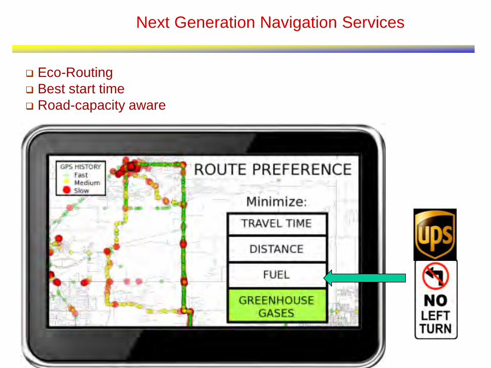
Next Generation Navigation Services
Eco-Routing Best start time Road-capacity aware

20
Next Generation Navigation Services
Eco-Routing Best start time Road-capacity aware

21
Routing Challenges: Lagrangian Frame of Reference
Q? What is the cost of Path <A,C,D> with start-time t=1 ? Is it 3 or 4 ? Path T = 0 T = 1 T = 2 T = 3
<A,C,D> 4 3 5 4
<A,B,D> 6 4 4 3
Lagrangian Graph
Snapshots of a Graph
Details:A Critical-Time-Point Approach to All-Start-Time Lagrangian Shortest Paths: A Summary of Results, (w/ V. Gunturi et al.), Proc. Intl. Symp. on Spatial and Temporal Databases, Springer LNCS 6849, 2011. Complete results accepted for the IEEE Transactions on Knowledge and Data Engineering.
1 1

Spatio-temporal Graphs: Computational Challenges
Ranking changes over time Waits, Non FIFO Behavior Violates stationary assumption in Dynamic Programming
*Flights between Minneapolis and Austin (TX)
Violate assumption of Dijkstra/A*
Details:A Critical-Time-Point Approach to All-Start-Time Lagrangian Shortest Paths: A Summary of Results, (w/ V. Gunturi et al.), Proc. Intl. Symp. on Spatial and Temporal Databases, Springer LNCS 6849, 2011. Complete results accepted for the IEEE Transactions on Knowledge and Data Engineering.

Trends: Persistent Geo-Hazard Monitoring
• Environmental influences on our health & safety – air we breathe, water we drink, food we eat
• Surveillance – Passive > Active > Persistent – How to economically cover all locations all the time ? – Crowd-sourcing, e.g., smartphones, tweets, – Wide Area Motion Imagery

Outline
• Introduction • GPS • Location Based Services • Spatial Statistics
– From Mathematical (e.g., hotspot) – To Spatial (e.g., hot features)
• Spatial Database Management Systems • Virtual Globes & Remote Sensing • Geographic Information Systems • Conclusions
24

Spatial Statistics: Mathematical Concepts
• Spatial Statistics – Quantify uncertainty, confidence, … – Is it (statistically) significant? – Is it different from a chance event or rest of dataset?
• e.g., SaTScan finds circular hot-spots
• Model Auto-correlation, Heterogeneity, Edge-effect, … – Point Process, e.g., Ripley’s K-functions, SatScan – Geo-statistics, e.g., Kriging, GWR – Lattice-based models
25
26
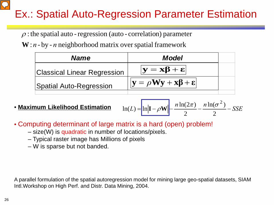
Ex.: Spatial Auto-Regression Parameter Estimation
Name Model
Classical Linear Regression
Spatial Auto-Regression
εxβy +=
εxβWyy ++= ρ
framework spatialover matrix odneighborho -by- : parameter n)correlatio-(auto regression-auto spatial the:
nnWρ
• Maximum Likelihood Estimation
• Computing determinant of large matrix is a hard (open) problem! – size(W) is quadratic in number of locations/pixels. – Typical raster image has Millions of pixels – W is sparse but not banded.
A parallel formulation of the spatial autoregression model for mining large geo-spatial datasets, SIAM Intl.Workshop on High Perf. and Distr. Data Mining, 2004.
SSEnnL −−−−=2
)ln(2
)2ln(ln)ln(2σπ
ρWI

Co-locations/Co-occurrence
• Given: A collection of different types of spatial events
• Find: Co-located subsets of event types
Details: Discovering colocation patterns from spatial data sets: a general approach, (w/ H. Yan et al.), IEEE Transactions on Knowledge and Data Engineering, 16(12), Dec. 2004.

30
MDCOP Motivating Example : Input • Manpack stinger
(2 Objects)
• M1A1_tank
(3 Objects)
• M2_IFV
(3 Objects)
• Field_Marker
(6 Objects)
• T80_tank
(2 Objects)
• BRDM_AT5 (enemy) (1 Object)
• BMP1 (1 Object)
31
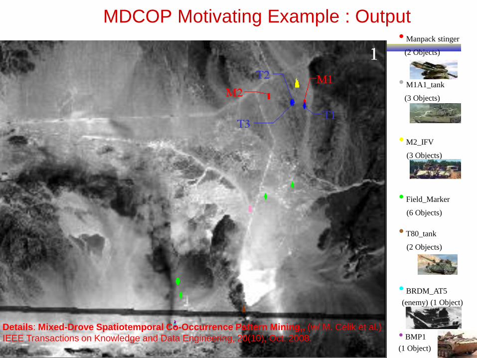
MDCOP Motivating Example : Output • Manpack stinger
(2 Objects)
• M1A1_tank
(3 Objects)
• M2_IFV
(3 Objects)
• Field_Marker
(6 Objects)
• T80_tank
(2 Objects)
• BRDM_AT5 (enemy) (1 Object)
• BMP1 (1 Object)
Details: Mixed-Drove Spatiotemporal Co-Occurrence Pattern Mining,, (w/ M. Celik et al.) IEEE Transactions on Knowledge and Data Engineering, 20(10), Oct. 2008.


Legionnaires’ Disease Outbreak in New York
33 Source: Ring-Shaped Hotspot Detection: A Summary of Results, IEEE ICDM 2014 (w/ E. Eftelioglu et al.)

Trends: Spatial-Concept Aware Patterns
• Spatial Concepts – Natural geographic features, e.g., rivers, streams, … – Man-made geographic features, e.g., transportation network – Spatial theories, e.g., environmental criminology – doughnut hole
• Spatial-concept-aware patterns – Hotspots: Circle => Doughnut holes – Hot-spots => Hot Geographic-features
Details: Identifying patterns in spatial information: a survey of methods, Wiley Interdisciplinary Reviews: Data Mining and Know. Discovery, 1(3):193-214, May/June 2011. (DOI: 10.1002/widm.25).

Outline
• Introduction • GPS • Location Based Services • Spatial Statistics • Spatial Database Management Systems
– Scalability => Privacy
• Virtual Globes & Remote Sensing • Geographic Information Systems • Conclusions
35

Spatial Databases for Geometry
• Spatial Querying – Geo-code, Geo-tag. Checkin, Geo-fence – Set based querying
• Spatial Querying Software
• OGC Spatial Data Type & Operations • Spatial Ops.: inside, overlap, distance, area, … • Data-structures: B-tree => R-tree • Algorithms: Sorting => Geometric
36

Geo-Security & Geo-Privacy • Operational Security Advice by US Army: Avoid Geo-tags!
– Q. Why?

Social Media Roundup
“I ran a little experiment. On a sunny Saturday, I spotted a woman in Golden Gate Park taking a photo with a 3G iPhone. Because iPhones embed geodata into photos that users upload to Flickr or Picasa, iPhone shots can be automatically placed on a map. At home I searched the Flickr map, and score—a shot from today. I clicked through to the user’s photostream and determined it was the woman I had seen earlier. After adjusting the settings so that only her shots appeared on the map, I saw a cluster of images in one location. Clicking on them revealed photos of an apartment interior—a bedroom, a kitchen, a filthy living room. Now I know where she lives.”
The following was published in Wired Magazine in 2009

Challenge: Geo-privacy, …
• Emerging personal geo-data – Trajectories of smart phones, Google map search, …
• Privacy: Who gets my data? Who do they give it to? What promises do I get? • Groups: Civil Society, Economic Entities, Public Safety ,Policy Makers

Outline
• Introduction • GPS • Location Based Services • Spatial Statistics • Spatial Database Management Systems • Virtual Globes & Remote Sensing
– Quilt => Time-travel & Depth
• Geographic Information Systems • Conclusions
40

Remote Sensing – Agriculture Monitoring
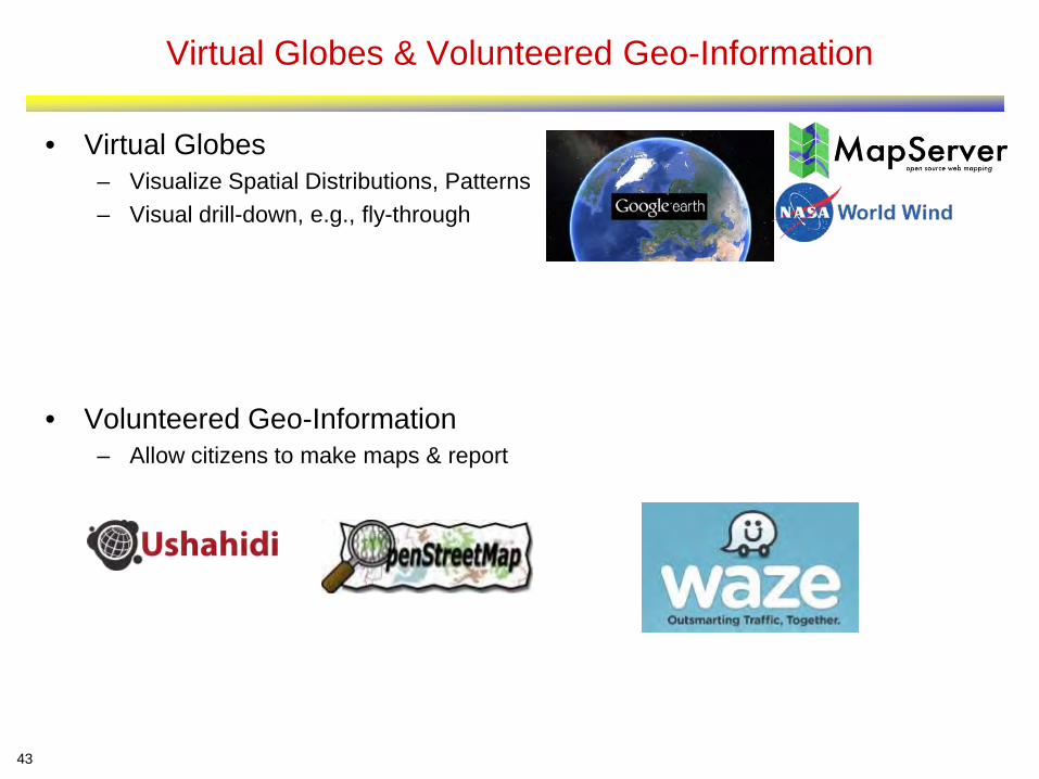
Virtual Globes & Volunteered Geo-Information
• Virtual Globes – Visualize Spatial Distributions, Patterns – Visual drill-down, e.g., fly-through
• Volunteered Geo-Information – Allow citizens to make maps & report
43

Opportunities: Time-Travel and Depth in Virtual Globes
• Virtual globes are snapshots
• How to add time? – Ex. NASA NEX, Google Earth Engine, – Ex. Google Timelapse: 260,000 CPU
core-hours for global 29-frame video
http://googleblog.blogspot.com/2013/05/a-picture-of-earth-through-time.html

Global Population
Global Temperature
State
Nexus Dashboard
Sea-Surface Temperature Anomaly
Aral Sea Shrinkage (1978-2014) Due to Cotton Farms
Alerts
Global Population
Trends
Emerging Raster SBD

Outline
• Introduction • GPS • Location Based Services • Spatial Statistics • Spatial Database Management Systems • Virtual Globes & Remote Sensing • Geographic Information Systems
– Geo => Beyond Geo
• Conclusions
46

Geographic Information Systems & Geodesy
• GIS: An umbrella system to – capture, store, manipulate, analyze, manage, and
present diverse geo-data. – SDBMS, LBS, Spatial Statistics, … – Cartography, Map Projections, Terrain, etc. – Q? How to model time? Spatio-temporal?
• Reference Systems – Which countries in North Korea missile range? – 3D Earth surface displayed on 2D plane – Spherical coordinates vs. its planar projections – Q? What are reference systems for time?
47 Original Correction
http://odt.org/hdp/

Opportunities: Beyond Geographic Space
• Spaces other than Earth – Challenge: reference frame?
• Ex. Human body – What is Reference frame ?
• Adjust to changes in body • For MRIs, X-rays, etc.
– What map projections? – Define path costs and routes to reach a brain tumor ?
Oliver, Dev, and Daniel J. Steinberger. "From geography to medicine: exploring innerspace via spatial and temporal databases." Advances in Spatial and Temporal Databases. Springer Berlin Heidelberg, 2011. 467-470.
http://convergence.ucsb.edu/issue/14
Outer Space Moon, Mars, Venus, Sun, Exoplanets, Stars, Galaxies
Geographic Terrain, Transportation, Ocean, Mining
Indoors Inside Buildings, Malls, Airports, Stadiums, Hospitals
Human Body Arteries/Veins, Brain, Neuromapping, Genome Mapping
Micro / Nano Silicon Wafers, Materials Science

Outline
• Introduction • GPS • Location Based Services • Spatial Statistics • Spatial Database Management
Systems • Virtual Globes & Remote Sensing • Geographic Information Systems • Conclusions
49
Recommendations
• Spatial Computing has transformed our society – It is only a beginning! – It promises an astonishing array of opportunities in coming decade
• However, these will not materialize without support • Universities
– Institutionalize spatial computing • GIS Centers, a la Computing Centers of the 1960’s
– Incorporate spatial thinking in STEM curriculum • During K-12, For all college STEM students?
• Government – Increase support spatial computing research – Larger projects across multiple universities – Include spatial computing topics in RFPs – Include spatial computing researchers on review panels – Consider special review panels for spatial computing proposals
50

Primary Sources
• Spatial Computing, Communications of the ACM, 59(1), Jan. 2016. • From GPS and Virtual Globes to Spatial Computing 2020, Computing
Community Consortium Report, 2013. www.cra.org/ccc/visioning/visioning-activities/spatial-computing


