Embed Size (px)
Citation preview

1
Intr
oduc
tion
This guide takes you on a geological
walking tour of the Frame Lake
Trail and describes the rocks and
geological features along the way.
The hike begins at the Visitor’s
Centre and continues clockwise
around Frame Lake. You will find the
accompanying geology map a useful
tool for navigating the trail and for
keeping track of the exposed rock
types along the trail.
As shown on the map, the Frame Lake
Trail is a 7-kilometre loop that can
be completed by a moderate walker
in about 1.5 hours. In order to fully
appreciate the geological features,
allow more time to complete the
circuit. Similar rocks appear along
the length of the trail, therefore the
same rock types may be seen along
the route.
The trail is paved from the RCMP
building on the town side to Stanton
Hospital on Frame Lake’s south-side,
but for the most part, the trail has
lots of rocks to clamber over, wooden

2 3
The
Geo
logi
cal M
ap
The rocks that you are walking over
are more than 2.6 billion years old
and are made up of many different
rock types, often composed of a
number of different grains (minerals).
The various minerals that appear
together are related to how the
rock formed and provide clues for
geologists to help them determine
what processes formed the rocks
and better understand the earth.
Rocks are divided into three main
types based on their origin: Igneous,
Sedimentary and Metamorphic.
The Frame Lake Trail is underlain by
both volcanic and plutonic igneous
rocks. The volcanic rocks formed
about 2,700 million years ago during
a time known as the Archean Eon.
The volcanic rocks in the Yellowknife
area are called the Kam Formation
and hosted the former Con and
Giant gold mines. The plutonic rocks
are also Archean and were formed
about 100 million years after the
volcanic rocks.Take your time and enjoy.
bridges across low swampy areas and
gravel paths. Look for orange capped
grey metal posts embedded in the
rocks and white painted prospector
symbols along the way where there is
no obvious path. Sturdy footwear
and insect repellent are recommended.
Please remember to bring your litter
bag with you.
The flora and fauna of this sub-arctic
environment are in delicate balance
- please show respect by staying on the
trail and do not pick flowers or plants.
The trail has many scenic lookouts
with benches and signs along the way
detailing the flora and fauna that you
may encounter: fireweed, foxtail barley,
wild roses bushes, creeping juniper,
paper birch, jack pine and black spruce
trees, in addition to a wide variety of
other trees, flowers, bushes and plants
which can all be seen at various points
along the trail.

4 5
Station Guide to the Frame Lake TrailRemember to refer to the geological map frequently and as you
proceed along the trail you may begin to recognize familiar rock
types. This guide highlights some of the interesting geological
features in the area.
Station 1
The diamond drill on display is
one of the early models used for
exploration by Giant Mine - similar
drills are used today. The drill
brings up a cylindrical core of
rock from below the surface and
geologists examine and analyze it
for mineral content, including gold.
Station 2
Behind the playground equipment
at Somba K’e Park, formerly Petitot
Park, the volcanic rocks preserve
glacial scours (scrape marks) and
striae (scored lines). Geologists use
these features to determine the
direction the glaciers travelled. In
this case, the glacier ice was moving
roughly southwestward.
The contact between the Kam
Formation and the Western
Granodiorite (a type of granite)
is the most obvious geological
feature of the trail. Other symbols
indicating the location of faults,
shear zones, gabbro or diabase
dykes, lakes and areas covered
with sand and gravel (overburden)
are also shown on the map. The
symbols are explained in the map
legend. The geological map is
simplified so that only the largest
and most easily recognizable
features are shown.

6 7
After the glaciers retreated,
most of the western
Northwest Territories
was covered by a huge
lake called Glacial Lake
McConnell. When the lake
receded fi ne sand was
left in low lying areas, like
McNiven Beach and the
sand pits near the airport.
When you reach the Ruth Inch Memorial Pool, on your left past
the playground and mini-golf, look to your right across Frame Lake
towards the pink hills near the hospital. Notice that the rock at the
base of the hill is dark green, whereas the rocks of the hill above
are defi nitely pink in colour. This is a geological contact (the surface
between two diff erent rock types).
Station 5
After crossing the small wooden
foot bridge the trail winds up a
small incline. At the top of the rise,
observe the pink granite veins
crosscutting the dark volcanic
rocks on both sides of the trail. Try
to follow these and imagine the
magma squeezing into these cracks.
As the glaciers receded they also rounded, smoothed and
sometimes even polished the rocks as a result of moving back and
forth over them. You will see both glacial effects along the trail.
Station 3
Wander out to the right
of the trail onto the point
of land that juts out into
Frame Lake.
Look across Frame Lake to the
island and you will see a white
quartz vein. This suggests that the
quartz fluid came into the rock as
a crack was opening up.
Station 4
The depression that forms McNiven Beach is present because the
area is underlain by the Pud Fault. This fault has moved the rocks
on one side by over 400 metres relative to the other side. If you
examine the geology map you will notice that the rocks do not
connect across this fault line.
8 9
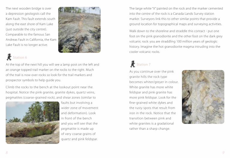
The large white “X” painted on the rock and the marker cemented
into the centre of the rock is a Canada Lands Survey station
marker. Surveyors link this to other similar points that provide a
ground location for topographical maps and surveying activities.
Walk down to the shoreline and straddle this contact - put one
foot on the pink granodiorite and the other foot on the dark grey
volcanic rock: you are straddling 100 million years of geologic
history. Imagine the hot granodiorite magma intruding into the
cooler volcanic rocks.
Station 7
As you continue over the pink
granite hills the rock type
becomes whiter/greyer in colour.
White granite has more white
feldspar and pink granite has
more pink feldspar. Look for the
fine-grained white dykes and
the rusty spots that result from
iron in the rock. Notice that the
transition between pink and
white granites is a gradational
rather than a sharp change.
The next wooden bridge is over
a depression geologists call the
Kam Fault. This fault extends south
along the east shore of Kam Lake
( just outside the city centre).
Comparable to the famous San
Andreas Fault in California, the Kam
Lake Fault is no longer active.
Station 6
At the top of the next hill you will see a lamp post on the left and
an orange topped trail marker on the rocks to the right. Much
of the trail is now over rocks so look for the trail markers and
prospector symbols to help guide you.
Climb the rocks to the bench at the lookout point near the
hospital. Notice the pink granite, granite dykes, quartz veins,
pegmatites (coarse-grained rock), and shear zones (similar to
faults but involving a
wider zone of movement
and deformation). Look
in front of the bench
and you will see that the
pegmatite is made up
of very coarse grains of
quartz and pink feldspar.
10 11
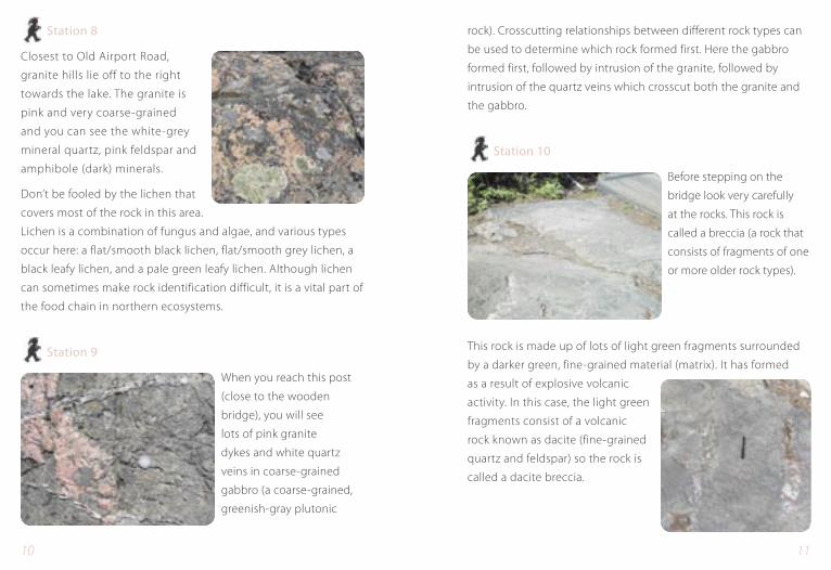
rock). Crosscutting relationships between different rock types can
be used to determine which rock formed first. Here the gabbro
formed first, followed by intrusion of the granite, followed by
intrusion of the quartz veins which crosscut both the granite and
the gabbro.
Station 10
Before stepping on the
bridge look very carefully
at the rocks. This rock is
called a breccia (a rock that
consists of fragments of one
or more older rock types).
This rock is made up of lots of light green fragments surrounded
by a darker green, fine-grained material (matrix). It has formed
as a result of explosive volcanic
activity. In this case, the light green
fragments consist of a volcanic
rock known as dacite (fine-grained
quartz and feldspar) so the rock is
called a dacite breccia.
Station 8
Closest to Old Airport Road,
granite hills lie off to the right
towards the lake. The granite is
pink and very coarse-grained
and you can see the white-grey
mineral quartz, pink feldspar and
amphibole (dark) minerals.
Don’t be fooled by the lichen that
covers most of the rock in this area.
Lichen is a combination of fungus and algae, and various types
occur here: a flat/smooth black lichen, flat/smooth grey lichen, a
black leafy lichen, and a pale green leafy lichen. Although lichen
can sometimes make rock identification difficult, it is a vital part of
the food chain in northern ecosystems.
Station 9
When you reach this post
(close to the wooden
bridge), you will see
lots of pink granite
dykes and white quartz
veins in coarse-grained
gabbro (a coarse-grained,
greenish-gray plutonic

12 13
Station 12
On the hilltop, between the two
posts and before reaching the
stairs, look for large tan coloured
phenocrysts (large crystals) of
feldspar up to 3 cm in length within
a gabbro dyke.
Station 13
Which rock types look
like they do not come
from nearby? You will
observe some flat red
sandstone boulders
along with granite,
sedimentary rocks and
volcanic rocks of different
colour. The sandstone
does not represent a local rock type. All of these boulders were
transported here by the glaciers. The degree of rounding of a
boulder can sometimes help to determine the distance it was
transported. The most rounded boulders have been transported
the farthest distance.
Just before the next little wooden foot bridge there are a few bands
of quartz. These are called tension gashes and formed as the dacite
split open allowing the quartz fl uid to fi ll in the cracks.
Station 11
Look around the trail signs and
benches and identify the pale tan
coloured dacite. Here the dacite
is not broken up or brecciated
but forms pillows that have large
gas bubbles infilled with white
quartz and calcite. The green
rounded patches up to 30 cm in
diameter largely consist of epidote,
a pistachio-coloured mineral
that is common in low-grade
metamorphic rocks.
The dacite is crosscut by an approximately 1 metre wide black
gabbro dyke that parallels the trail. As you continue parallel to the
dyke you may be aware of a change in rock type. You will begin in
a spotted, very coarse-grained gabbro sill and as you go farther
along you will cross over the contact into the dacite. The gabbro
dyke crosses the spotted gabbro sill and dacite indicating that the
gabbro dyke is the most recent (youngest) rock type here.

14 15
or faults, separating individual segments of the same vein.
Geologists use this kind of feature to determine the direction and
amount of displacement that occurred across a fault.
Station 16
Look closely at the rocks used
to construct the walkway to the
‘Place of the People’. These pieces
of sandstone and mudstone are
sedimentary rocks brought here
from the East Arm of Great Slave
Lake. Look for the preserved ripple
marks in some of these rocks.
Wave action formed these marks
in the same way that ripples
form on modern sandy beaches.
This feature tells us that this rock
formed under water. The red colour in the rock is due to the
presence of hematite, an oxidized iron mineral.
Station 17
We finish our tour at the Miners’ Monument. This is dedicated
to all the workers who lost their lives working in the mines of
the Northwest Territories. The gold mining industry began in
Yellowknife in the late 1930s and to date, close to 15,000,000
ounces of gold have come from the gold mines in this area.
Station 14
Beneath the large
explanatory trail sign
called “Waterlords,” look
for pillowed basaltic
volcanic rock forms. These
are rounded blobs with
lighter edges which were
once the outer edges of
lava tubes that cooled
quickly in the sea and formed a crust around the interior molten
lava that crystallized and cooled to form the rounded, pillow
shapes. The pillows have small round white spots in them. These
are preserved gas bubbles called vesicles that been infilled with
quartz and calcite.
Station 15
This outcrop lies to your left
between the Legislative Assembly
and the ‘Place of the People’ (an
elevated pyramid-like structure).
A 5 cm wide quartz vein cuts
through the surrounding grey
dacite. Notice that the vein is
segmented with small cracks,

16 17
Glossary of Selected Terms
Basalt: A volcanic rock formed by lava that is rich in
magnesium and iron. Most of the rocks along
the Frame Lake Trail are basalt and are often
referred to as greenstones because they tend to
have a greenish weathered surface.
Batholith: A large mass of plutonic rock having a surface
exposure of more than 100 square kilometres.
A granodiorite batholith underlies part of the
trail area.
Breccia: A textural term for rocks containing angular
fragments of one or more rock types.
Contact: A place or surface where two different types or
ages of rock meet.
Dacite: A volcanic rock made up of fine-grained quartz
and feldspar that is similar in composition
to granite.
Diabase: A common basic igneous rock usually occurring
in dykes or sills.
Dyke: A long and relatively thin body of igneous rock
that, while in the molten state, cut across the
layers of rock into which it has intruded.
Although Yellowknife’s
Con and Giant mines are
now closed, they played
a huge role in shaping
the community. And
who knows … maybe
there’s more gold near
our city that hasn’t been
discovered yet!

18 19
deep below and forms a coarse-grained plutonic
rock which is later exposed by erosion. Most of the
Frame Lake area is underlain by volcanic (green
on the map) and plutonic (pink on the map)
varieties of igneous rock.
Metamorphic Rocks which have undergone a change in texture
or composition as the result of heat and/or
pressure. Most of the igneous rocks in the area are
metamorphosed (changed).
Pegmatite: A coarse-grained (most grains are larger than
1 cm) igneous rock, usually irregular in texture
and composition and similar to a granite in
composition; it usually occurs in dykes or veins.
There are many pegmatites along the Ingraham
Trail, especially in the Frame Lake South
neighbourhood near the hospital.
Phenocrysts: Large, conspicuous, usually well-formed crystals
that occur in a volcanic rock or a dyke.
Sedimentary Rocks that are created by the erosion of other
rocks and deposited by surface processes such as
wind, water (lakes, rivers, oceans) and glaciers.
Sedimentary rocks form where sediment (eroded
particles) accumulates - such as the sand on
the bottom of lakes, along shorelines and even
in deserts (dunes). As the sediment builds up,
Fault: A crack or fracture in the Earth’s crust along which
movement has taken place.
Gabbro: A dark greenish-grey plutonic rock that is coarser-
grained because it cooled slowly below the surface
of the earth.
Geology: The science concerned with the study of the Earth’s
processes including the formation of the rocks and
minerals that make up the Earth.
Granite: A coarse-grained (intrusive) igneous (plutonic)
rock consisting of quartz, feldspar and mica.
The Frame Lake Trail has lots of both pink and
white granite.
Granodiorite: A type of granite that contains more sodium or
calcium-rich feldspar than potassium feldspar. In
the Frame Lake area, granodiorite is white to pink
and primarily coarse-grained.
Igneous Rocks that have solidified from a molten material
(magma) that originated deep below the surface
of the earth where the temperature and pressure
are high. If the magma finds a path to the surface,
it erupts, cools quickly and solidifies to form a fine-
grained volcanic rock. This is like the present-day
activity on Hawaii or Iceland. If the magma never
reaches the surface, it slowly cools and crystallizes
Rock:
Rock:
Rock:
20 21
We hope you have enjoyed your walk around the Frame Lake Trail
and welcome your comments. For further information on trails,
facilities, or general travel, please contact:
The Northern Frontiers Visitors Centre
#4, 4807-40th Street
Yellowknife, NT, Canada X1A 3T5
Phone: (867) 873-4262 Fax: (867) 873-3654
Toll Free in North America: 1-877-881-4262
Website: www.northernfrontier.com
For further information on NWT geology, please contact or visit:
Northwest Territories Geoscience Office
Box 1500
4601-B 52nd Avenue
Yellowknife, NT, Canada X1A 2R3
Phone: (867) 669-2636 Fax: (867) 669-2725
Email: [email protected]
Website: www.nwtgeoscience.ca
Minerals Development Directorate
6th Floor, Bellanca Building
4914 50th Street
Yellowknife, NT, Canada X1A 3G5
Phone: (867) 669-2571 Fax: (867) 669-2705
Email: [email protected]
Website: http://nwt.inac.gc.ca
Photos: Andrea Mills, NWT Geoscience Office
Liz Gilbert, DIAND
it is subjected to pressure so it compacts and
consolidates to form a sedimentary rock such
as sandstone. Other sedimentary rocks include
mudstone, salt, coal and limestone (formed from
coral reefs).
Sill: A layer of igneous rock that occurs between,
and parallel to, layers of older sedimentary or
volcanic rock (similar to a dyke, but generally
much larger).
Tuff: Rock composed of fine volcanic ash.
Vein: A typically thin, sheet-like body that infills a
crevice or crack in the rock. A vein can contain
one or more mineral types. Quartz veins are
common along the Frame Lake Trail.
Vesicles: Rounded gas bubbles that are preserved in
solidified magma or lava.