Embed Size (px)
Citation preview


10
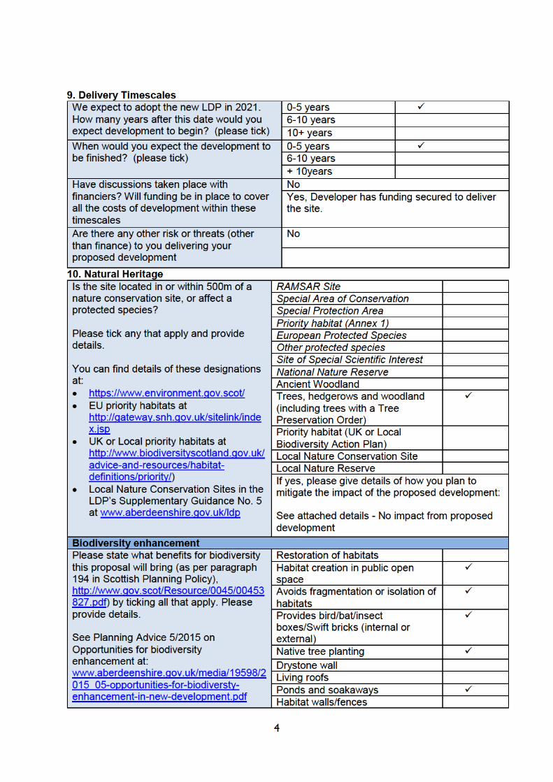
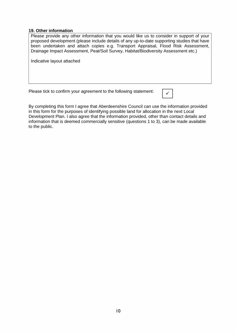
19. Other information
Please provide any other information that you would like us to consider in support of your proposed development (please include details of any up-to-date supporting studies that have been undertaken and attach copies e.g. Transport Appraisal, Flood Risk Assessment, Drainage Impact Assessment, Peat/Soil Survey, Habitat/Biodiversity Assessment etc.) Indicative layout attached
Please tick to confirm your agreement to the following statement: By completing this form I agree that Aberdeenshire Council can use the information provided in this form for the purposes of identifying possible land for allocation in the next Local Development Plan. I also agree that the information provided, other than contact details and information that is deemed commercially sensitive (questions 1 to 3), can be made available to the public.


1
ABERDEENSHIRE LOCAL DEVELOPMENT PLAN 2021
CALL FOR SITES
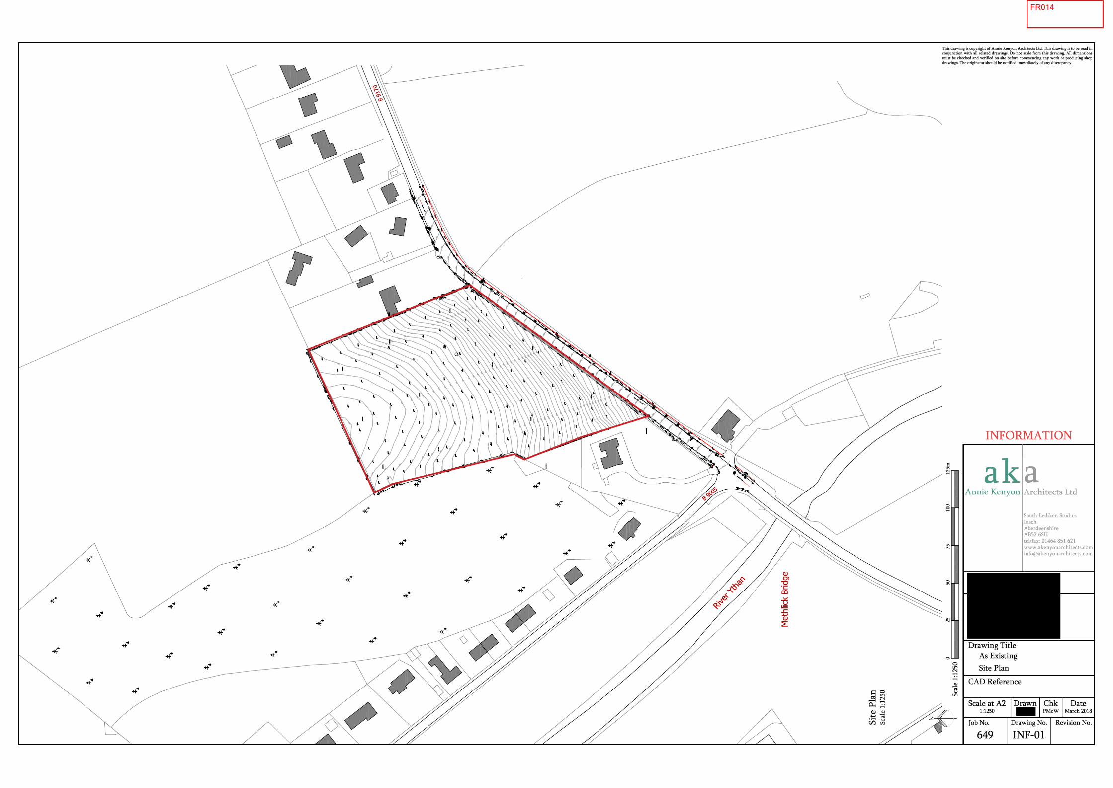
PAPER APART – Land West of Black Craigs, Methlick
Ryden LLP have been instructed on behalf of to submit a Development
Bid to Aberdeenshire Council’s recent call for sites, for their land interests at Methlick.
Q4. Site Details
The land to the west of Black Craigs, Methlick is identified in the map below and sits to the north of
village off the B9170 just after crossing Methlick Bridge over the River Ythan. Black Craigs wooded
area bounds the site to the west, with existing residential properties forming the eastern boundary.
Agricultural field extend beyond the northern boundary and the southern edge of the site is bound by
the B9170, which facilitates direct access into the site.


4
Q.12 Landscape Impact
The local landscape has been analysed as part of the Masterplan document. The site is in agricultural
use and as such has little to offer in terms of established landscaping or features and is not located
within any area of landscape significance. The development of this site will therefore have little
landscape impact but provides an opportunity to create an attractive gateway and entrance approach
to the village from the north via the B9170.
The site slopes down from the north east to the south west, however the development offers the
opportunity for some regrading works and landscaping to create a welcoming aesthetic, particularly on
approach from the B9170. The site enjoys long vistas towards the River Ythan, giving it a distinctive
character and provides opportunities to create a unique sense of place.
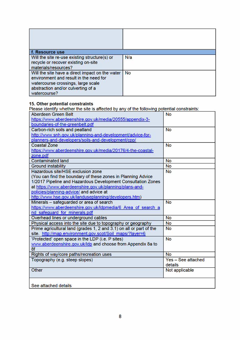
Q.13 Flood Risk
SEPA’s Indicative Flood Map provides predictive guidance on the possible extent of functional
floodplain (1 in 200 year flood event). It demonstrates the site is entirely out with the floodplain which
lies to the south and is not at risk of any surface water flooding.
Q.14 Infrastructure
Water/Drainage - New gravity foul and surface water sewers will be provided to service the
development and these will be located within the new roads and areas of open space where necessary.
It is understood that there is substantial capacity in the Turriff Water Treatment Works and also within
the local network to accommodate the proposed development. It is also understood through a capacity
search that there is sufficient capacity within the Methlick Waste Water Treatment Works to
SEPA Flood Map Extract

5
accommodate a development of this scale. The bid represents a minor increase of three units to the
five which are currently allocated and will be programmed into the SW’s capacity.
Education – the 2017 based School Roll Forecasts indicate that Methick Primary School has a capacity
range of 97-120 pupils. It is currently at 92% of capacity, but has a rising school roll, expected to be
over capacity by 2022. The existing allocation of 5 units are already programmed development within
the School Roll forecasts, therefore a small addition of three units may require developer contributions
to be made toward education.
Transport – Good access to the site exists via the B9170 immediately to the south of the site. Roads
development had previously assessed a proposal for 5 units under APP/2014/0219 and had no
objections. Visibility onto the B9170 is good and the site will be designed in accordance with Designing
Streets principles and to an adoptable standard.
Public Transport – The site is located close to existing bus routes, offering a range of services and
connectivity north and south. Stagecoach Service 290/291 serves the settlement to and from Aberdeen
with a bus stop located within the centre of the village at the War Memorial, less than 400m from the
site. The 292 service operates between Methlick and Ellon, the 293 between Methlick and Fyvie and
the 452 service runs to and from Fraserburgh.
Active Travel – The village is served by an established network of pedestrian footways which provide
direct and safe access from the site to the village and associated amenities/services. All areas of the
village are generally within 10 -15 minutes walking distance from the site. An existing Core Path is
located close to the site along the bank of the River Ythan.
Public Open Space – the proposal will provide the opportunity to enhance the green space network,
both for the site and the wider area. The proposals create a landscaped SUDs area providing feature
open space at the village and site entrance, which will be landscaped with native planting. Screen
planting along the southern boundary of the site will provide a green corridor and landscaping which
will improve this approach to the village. An extensive area of parkland to the north will provide
significant areas of open space which will be linked by footpaths and tree lined streets throughout the
development and wider area.
The site will meet the open space standards as set out in Appendix 2 of the Aberdeenshire Parks and
Open Space Strategy. Significantly more than 40% of the site is retained as open space and there are
opportunities for a range of uses within that open space. The open space audit makes reference to
open space for food growing and there may be opportunities to provide this on site due to the large
amount of open space proposed.
Topography – The site has a sloping gradient rising from the south east to the north west. This will
require some slight regrading works.
6
Q.17 Community Engagement
No formal public consultation has taken place in relation to the development of this site. Given it is of
a small scale (less than 50 units and 2ha net developable area) there would be no requirement under
current planning legislation for pre-application consultation. Our client would however be content to
discuss any proposals with the Community Council.
Q.18 Residual Value and Deliverability
Our client is committed to the delivery of the site. Annie Kenyon Developments has an option on the
land and is eager to deliver the site.
The previous planning permission in principle (APP/2014/0219) had established indicative plot
boundaries for 5 large detached houses aimed more towards the higher end of the market, however
market testing has indicated that smaller 3 and 4 bed family homes may be more appropriate and
marketable in this area. Accordingly, the requested increase to the existing OP2 site boundary in the
2017 LDP to reflect the previous H2 allocation boundary within the 2012 LDP, will allow for a
sympathetic mix of family homes.