Embed Size (px)
Citation preview

FOXON BOULEVARD (ROUTE 80) CORRIDOR STUDY Interstate 91 to Mill Street/Thompson Street
City of New Haven & Town of East Haven New Haven County
July 2012
FINAL REPORT
Prepared by:
ENGINEERS ARCHITECTS PLANNERS 20 North Main Street, Norwalk, CT
Bethany - Branford - East Haven - Guilford - Hamden - Madison - Meriden - Milford New Haven - North Branford - North Haven - Orange - Wallingford - West Haven – Woodbridge
SOUTH CENTRAL REGIONAL COUNCIL OF GOVERNMENTS
Carl Amento, Executive Director
The RBA Group of Connecticut, LLC

FOXON BOULEVARD (ROUTE 80) CORRIDOR STUDY I-91 to Mill Street/Thompson Street
TABLE OF CONTENTS
EXECUTIVE SUMMARY .............................................................................................................. i I. INTRODUCTION ............................................................................................................ 1
II. PROJECT IDENTIFICATION AND EVOLUTION ............................................................... 1
A. PROJECT IDENTIFICATION .................................................................................... 1 1. Project Type ................................................................................................... 1 2. Project Description ........................................................................................ 1
III. ROADWAY CONDITIONS AND NEEDS .......................................................................... 1
A. FUNCTIONAL CLASSIFICATION ............................................................................. 1 B. OWNERSHIP AND MAINTENANCE JURISDICTION ................................................ 1 C. CULTURE, TERRAIN AND CLIMATIC CONDITIONS ............................................... 2
1. Culture ............................................................................................................ 2 2. Terrain ............................................................................................................ 2 3. Climate ........................................................................................................... 2
D. EXISTING HIGHWAY SECTION .............................................................................. 2 1. Travel Lanes ................................................................................................... 2 2. Curb ................................................................................................................ 5 3. Median ........................................................................................................... 5 4. Grades and Curves ......................................................................................... 5 5. Intersection Geometry and Conditions ......................................................... 5 6. Parking Regulations........................................................................................ 5 7. Roadside Elements ......................................................................................... 6 8. Bikeways ........................................................................................................ 6
E. NON-STANDARD FEATURES AND NON-CONFORMING FEATURES ...................... 6 F. PAVEMENT AND SHOULDER CONDITIONS .......................................................... 6 G. GUIDE RAILING, MEDIAN BARRIERS AND IMPACT ATTENUATORS ..................... 8 H. TRAFFIC CONTROL DEVICES ................................................................................. 8 I. STRUCTURES ........................................................................................................ 8 J. HYDRAULICS AT BRIDGES AND LARGE CULVERTS ............................................... 8 K. DRAINAGE SYSTEMS ............................................................................................ 9 L. SOIL AND FOUNDATION CONDITIONS ................................................................. 9 M. UTILITIES ............................................................................................................... 9 N. RAILROADS ........................................................................................................... 9 O. VISUAL ENVIRONMENT ........................................................................................ 9 P. PROVISIONS FOR PEDESTRIANS AND BICYCLISTS ................................................ 9

FOXON BOULEVARD (ROUTE 80) CORRIDOR STUDY I-91 to Mill Street/Thompson Street
TABLE OF CONTENTS CONT’D IV. EXISTING CONDITION DATA COLLECTION AND ANALYSIS........................................ 10
A. TRAFFIC VOLUMES ............................................................................................. 10 B. TRAVEL SPEEDS .................................................................................................. 11
1. Speed Limits ................................................................................................. 11 2. 85th-Percentile Speeds ................................................................................. 11 3. Average Speeds ............................................................................................ 11
C. TRAFFIC ANALYSIS .............................................................................................. 11 D. ACCIDENT ANALYSIS ........................................................................................... 12
1. Methodologies ............................................................................................. 12 2. Results .......................................................................................................... 12
E. FIELD OBSERVATIONS ........................................................................................ 13 1. Methodologies ............................................................................................. 13 2. Results .......................................................................................................... 13
V. PROPOSED IMPROVEMENTS ..................................................................................... 18
VI. IDENTIFICATION OF SHORT-TERM AND AND LONG-TERM MITIGATION ................. 19
VII. CONCEPTUAL DESIGN PLANS ..................................................................................... 25 VII. PROJECT COST AND SCHEDULE .................................................................................. 28

FOXON BOULEVARD (ROUTE 80) CORRIDOR STUDY I-91 to Mill Street/Thompson Street
LIST OF FIGURES
Figure No. Name Follows Page 1. Project Location Map ...............…..…………………………………………………………………1 2. Existing Bicycle Facilities Map ........................................................................... 6
LIST OF TABLES
Table 1. Average Daily Traffic Volumes at Selected Intersections ............................... 10 Table 2. Existing 85th Percentile Speeds ....................................................................... 11 Table 3. Existing Average Speeds ................................................................................. 11
APPENDICES
Appendix A. Accident Data
Foxon Boulevard Intersection and Corridor Accident Summaries
Accident Experience Summary Report Appendix B. Conceptual Design Plans (Exhibits 1 - 9) Appendix C. Existing and Proposed Typical Sections Appendix D. Project Correspondence
March 7, 2012 Meeting Minutes
June 13, 2012 Stakeholder’s Meeting Notes
June 19, 2012 Stakeholder’s Meeting Notes
June 26, 2012 Public Information Meeting Sign In Sheet
June 26, 2012 Public Information Meeting Comments June 26, 2012 Public Information Meeting Power Point Presentation
Slides Appendix E. Conceptual Construction Cost Estimate

FOXON BOULEVARD (ROUTE 80) CORRIDOR STUDY I-91 to Mill Street/Thompson Street
i
EXECUTIVE SUMMARY A. Introduction
The RBA Group conducted a study to investigate means by which to improve safety along a 1.5-mile segment of Foxon Boulevard (CT Route 80) from the Interstate 91 (I-91) interchange to Thompson Street located in the City of New Haven and Town of East Haven, Connecticut. The study was initiated by the South Central Regional Council of Governments (SCRCOG) on behalf of the City and Town in 2011. The study presents recommendations to improve transportation deficiencies as well as to improve and provide pedestrian and bicycle accessibility along the Foxon Boulevard corridor. To address concerns by SCRCOG, the local communities and stakeholders, The RBA Group was retained to perform an analysis of existing traffic and safety conditions along the subject corridor and to develop engineering solutions that will result in improvements of the safety for all users, while minimizing impacts to the local community. Tasks performed for this study included the following:
1. Conduct a walk-through of the project corridor to assess existing roadway geometric
conditions. 2. A review of accident data for a 3-year period to determine the most frequent types
of accidents and common contributing factors in those accidents. 3. Review of traffic volumes and travel speeds provided by ConnDOT. 4. Evaluation of vehicular and pedestrian safety issues along the corridor based on
accident data, travel speeds and existing roadway geometric conditions. 5. Assess existing pedestrian and bicycle facilities and accommodations. 6. Review transit deficiencies and amenities. 7. Development of conceptual designs to improve traffic and safety conditions as well
as pedestrian and bicycle facilities along the subject corridor.
B. Findings
Based on RBA’s analysis of accident and traffic data along with observations noted in the field, the following findings are offered:
Accidents:
There were a total of 420 accidents in a three year period between January 2007 and December 2009 along Foxon Boulevard within the study limits.
The accident analysis showed that the most frequent type of accidents on Foxon
Boulevard were rear-end, turning movement and sideswipe collisions. The majority of contributing factors included following too closely, failure to grant right of way and traffic control violations.
The rear end accidents occurring at Middletown Avenue, Quinnipiac Avenue and Eastern Street are likely due to the high amount of congestion during peak hour

FOXON BOULEVARD (ROUTE 80) CORRIDOR STUDY I-91 to Mill Street/Thompson Street
ii
periods in this area as well as the lack of full width shoulders. (Refer to the section on Traffic Capacity below) Further traffic capacity analyses are warranted to obtain a more comprehensive understanding of congestion in this area.
Rear end collisions in the Town of East Haven segment may be attributed to the higher vehicle speeds as recorded by ConnDOT at Crest Avenue and River Road (east of the project limits).
Speeds:
The 85th percentile speeds of drivers in the study area were found to be in the range of 40-48 mph, considerably higher than the posted speed limit of 35 mph.
Field Observations:
Sidewalk discontinuity was noted at several locations throughout the corridor: There is an existing pedestrian ramp on the north side of Foxon Boulevard
across from a McDonald’s and Walmart Shopping Center. Although this pedestrian ramp connects to a sidewalk along the south side of Foxon Boulevard there is no connecting sidewalk to the pedestrian ramp on the north side.
There is no sidewalk along the north side of Foxon Boulevard between the Days Inn and Global gas station just west of Quinnipiac Ave.
There is little or no sidewalk along the south side of Foxon Boulevard between the Walgreens store just east of Eastern Street and Strong Street. There is a short segment of sidewalk to the east and west of the Planet Fitness driveway between Crest Avenue and Fox Ridge Drive that abruptly ends.
There is little or no sidewalk along the north side of Foxon Boulevard between Old Foxon Rd. and the Monroe Muffler Brake and Service shop just east of South Dale Street. There is a short asphalt sidewalk between Dell Drive and Paul Street that does not connect to the east or west.
There are a number of existing pedestrian ramps along both the north and south sides of Foxon Boulevard between Old Foxon Road and South Dale Street that do not connect to any sidewalk.
There is an existing median barrier guide rail on Foxon Boulevard in the vicinity of
the Lowe’s shopping center east of Middletown Avenue. The end treatment for this guiderail is nonstandard and creates a potential hazard for motorists traveling westbound.
Varying median striping/excess pavement width was noted within the vicinity of the
Walmart and Dunkin Donuts shopping centers, at a segment of roadway between Eastern Street and Old Foxon Road, and within the vicinity of Highland Avenue.
Lack of amenities (i.e. refuge areas) at CT Transit bus stops.

FOXON BOULEVARD (ROUTE 80) CORRIDOR STUDY I-91 to Mill Street/Thompson Street
iii
Excessively long crosswalks were noted across Foxon Boulevard at the Quinnipiac Avenue and Eastern Street intersections.
Apex orientated pedestrian signals were noted at Eastern Street. These signals are
difficult to see as they are pointed diagonally across the intersection. Existing utility poles along the north side of Foxon Boulevard between View Street
and the Fox Haven Plaza driveway entrance are too close to the road and, as such, are within the clear zone.
Traffic Capacity:
Traffic capacity analyses were not included in the scope of this study, however based on field observations and stakeholder input, the following operational deficiencies exist: Traffic congestion on Foxon Boulevard, particularly during the peak PM period
(4pm-6pm) exists in the vicinity of Quinnipiac Avenue to Eastern Street. The eastbound direction, in particular, was observed to back up all the way to the northbound I-91 off ramp to Foxon Boulevard.
Traffic congestion also exists on the southbound approach of Eastern Street to Foxon Boulevard. Insufficient right turn storage capacity is one reported cause for the significant queues at this approach.
C. Proposed Improvements
Conceptual design plans were developed for SCRCOG’S consideration of short term and long term solutions to mitigate safety and accessibility issues throughout the Foxon Boulevard corridor.
Short Term Recommendations – Provide 5-foot Wide Bicycle Lanes
Reduce lane widths to 11 feet. Restripe median and left turn lane shadowing to meet current standards. Provide a 5-foot wide, striped bicycle lane along the eastbound and westbound
directions on Foxon Boulevard. Replace existing drainage grates with bicycle safe grates.
Potential Concerns/Impacts: In order to maintain a 5’ wide bicycle lane, roadway widening will be necessary at isolated, constrained locations throughout the project corridor. Although this widening can likely occur within the existing right of way, there are several locations where other options for providing bicycle access should be considered:
- Reduce bicycle lane width to 4’ in areas where only 1’ of widening would be needed to provide a 5’ wide bike lane. As per the 2012 edition of AASHTO’s “Guide for the Development of Bicycle Facilities”, a 4’ wide bicycle lane can be used “on extremely constrained, low speed roadways (45 mph or less) with curbs

FOXON BOULEVARD (ROUTE 80) CORRIDOR STUDY I-91 to Mill Street/Thompson Street
iv
but no gutter, where the preferred bike lane width cannot be achieved despite narrowing all other travel lanes to their minimum widths” This option may be desirable as it would eliminate the need to replace curb, pavement and/or buffer/snow storage areas between the curb and sidewalk for only a minor gain (1 foot or less) of roadway width.
- Use 14’ wide shared-use curbside lanes with “sharrow” pavement marking symbol(s). This option would avoid widening the roadway where providing a 5’ wide bicycle lane is not possible or practical. Such may be the case for areas with right of way concerns or for locations that would require only 1’ of widening. However, this option, if used in conjunction with a 5’ wide bicycle lane, would require bicyclists to travel utilizing Class II (designated bike lanes) and Class III (shared-use lanes) facilities throughout the project corridor.
Additional considerations in regards to widening Foxon Boulevard to maintain a 5’ wide bicycle lane include impacts to utility poles and possible eliminations to buffer/snow storage areas between the curb and sidewalk
Long Term Recommendations – Raised Medians, Bus Pads and Shelters, Gateway and Traffic Signal Upgrades
Provide 5’ wide sidewalks where they are lacking throughout the project corridor. Replace non-standard pedestrian ramps to meet ADA guidelines. Relocate pedestrian ramps and crosswalks at signalized intersections to reduce
crossing distances. Provide bus stop pads and shelters Provide a raised/planted median with traversable curbs at strategic locations. Provide a landscaped gateway within the median of Foxon Boulevard in the vicinity
of Middletown Avenue. Upgrade traffic signals with new signal heads, pedestrian countdown timers and
push-button assemblies. Modify traffic signal phasing and timing
D. Conclusion
After a thorough review of accident data, field observations, traffic signal plans, and roadway record plans we identified no significant factors that warrant immediate attention. Future discussion between SCRCOG, the Connecticut Department of Transportation and local municipalities are anticipated regarding the efficacy of the suggested improvements explored in this study. E. Further Studies
Significant rear-end accidents and congestion reported at the Eastern Street and Quinnipiac Avenue intersections indicate further traffic capacity analyses are warranted to optimize traffic progression through the corridor.

FOXON BOULEVARD (ROUTE 80) CORRIDOR STUDY I-91 to Mill Street/Thompson Street
1
I. INTRODUCTION
The South Central Regional Council of Governments (SCRCOG) requested this study be conducted in order to investigate pedestrian facility needs and deficiencies along Foxon Boulevard (Connecticut Route 80) from the Interstate 91 (I-91) interchange to Mill Street/Thompson Street located in the City of New Haven and Town of East Haven, New Haven County, Connecticut. For the purposes of this report, the corridor shall be identified as Foxon Boulevard although the roadway’s name changes to Foxon Road in the Town of East Haven. (See Figure 1 - Project Location Map.) The overall objective of this study is to identify feasible, cost-effective improvements that make the project corridor safer for pedestrians and bicyclists with minimal impacts to the community, the right-of-way, and roadway capacity.
II. PROJECT IDENTIFICATION AND EVOLUTION
A. PROJECT IDENTIFICATION
1. Project Type
This proposed project is being progressed as a highway safety project, incorporating data collection, field observations, accident analysis, and community input.
2. Project Description This project is located within the City of New Haven and Town of East Haven, New Haven County and proposes safety improvements for pedestrians, bicyclists and motorists.
III. ROADWAY CONDITIONS AND NEEDS A. FUNCTIONAL CLASSIFICATION
The Federal Functional Classification for Foxon Boulevard is "Urban Principal Arterial - Other".
B. OWNERSHIP AND MAINTENANCE JURISDICTION The State of Connecticut owns and maintains Foxon Boulevard (Route 80). The City of New Haven and Town of East Haven maintain the intersecting streets within their respective municipal boundaries.

FOXON BOULEVARD (ROUTE 80) CORRIDOR STUDY
CITY OF NEW HAVEN / TOWN OF EAST HAVEN
SCALE: N.T.S.
EASTERN
ST
MID
DLET
OW
N AV
E
DEL
L D
R
PAU
L ST
MIC
HAE
L CR
EST
AVE
MIL
L S
T
I - 9
1 NORTH
I - 9
1 SOUTH
O
MP
SON
ST
OLD FOXON R
D
S D
ALE
ST
FO
X ON
B O U L E V A R D
LOWE’S
WALMART
FIGURE 1 - PROJECT LOCATION MAP
N.T.S.
ROSS/WOODWARDPUBLIC SCHOOL
FAMILY DOLLARSHOPPING CENTER
AMES SHOPPING CENTER(JOB LOT STORE)
PLANETFITNESS
NEW HAVENBUSINESS PARK

FOXON BOULEVARD (ROUTE 80) CORRIDOR STUDY I-91 to Mill Street/Thompson Street
2
C. CULTURE, TERRAIN AND CLIMATIC CONDITIONS 1. Culture
The project study area consists primarily of commercial development with some residential homes fronting Foxon Boulevard from Paul Street to Green Street. Residential homes are predominately located along the side streets north and south of Foxon Boulevard beginning at Quinnipiac Avenue and heading east beyond the project limits at Mill Street/Thompson Street.
2. Terrain The topography of the land within the project limits is gently sloping with a gradual incline from west to east along the Foxon Boulevard corridor within the project limits.
3. Climate
There are no unusual weather conditions that may affect the design of the project.
D. EXISTING HIGHWAY SECTION
1. Travel Lanes
Foxon Boulevard from the I-91 interchange to Mill Street/Thompson Street is typically a four lane road with narrow shoulders and left turn lanes incorporated at the approaches to intersections and several large shopping centers. Dedicated right turn lanes are also provided for the westbound approach to Middletown Avenue and the eastbound approach to Quinnipiac Avenue. The side streets are typically one travel lane in each direction with widening for left and right turn lanes on the approaches to Foxon Boulevard at signalized intersections. Geometric details for each of the individual study area intersections are provided below. Foxon Blvd. at Middletown Avenue/I-91 Interchange At this signalized, four-way, intersection, there are four travel lanes on Foxon Boulevard, two eastbound and two westbound. In addition, there is a channelized right turn lane with raised island in the westbound direction and a left turn lane in the eastbound direction. Travel lanes are 11’ or 12’ wide with varying shoulder widths. On Middletown Avenue, there are two

FOXON BOULEVARD (ROUTE 80) CORRIDOR STUDY I-91 to Mill Street/Thompson Street
3
northbound travel lanes. Two southbound lanes are also provided, one left turn lane to eastbound Foxon Boulevard and another channelized right turn lane with a raised island to westbound Foxon Boulevard. The southern leg of this intersection serves as the off-ramp from Interstate 91 (I-91) to Foxon Boulevard. It consists of two northbound travel lanes, one of which is a shared left turn lane. The off-ramp also has a direct unsignalized connection (i.e. free right turn) to eastbound Foxon Boulevard. Foxon Blvd. at New Haven Plaza At this signalized, three-way, intersection,
there are five travel lanes on Foxon Blvd., three eastbound and two westbound. Double left turn lanes are also provided in the westbound direction for traffic heading south into New Haven Plaza. A single left turn lane is provided in the westbound direction, west of the intersection, for access to a McDonald’s, a car wash and a Lowe’s
shopping center. The eastbound right travel lane, which originated from the I-91 interchange off-ramp, is dropped east of this intersection. All lanes are approximately 11’ wide with the exception of the eastbound right lane which is approximately 12’. Two foot shoulders are provided on both sides of the road. The southern leg of this intersection consists of five lanes, two northbound left turn lanes to westbound Foxon Boulevard, a northbound right turn lane to eastbound Foxon Boulevard, and two southbound travel lanes into the shopping center. No shoulders are provided. Foxon Blvd. at Quinnipiac Avenue
At this signalized four-way intersection, there
are four travel lanes on Foxon Boulevard, two eastbound and two westbound. Left and right turn lanes are also provided in the eastbound direction and a single left turn lane is provided in the westbound direction. Lane widths are all 11’ and 2’ wide shoulders are provided on both sides of the road. Both the northbound and southbound approaches
to Foxon Boulevard from Quinnipiac Avenue consist of a left turn lane and a shared through/right turn lane. A single travel lane is provided heading north or south, away from Foxon Blvd.

FOXON BOULEVARD (ROUTE 80) CORRIDOR STUDY I-91 to Mill Street/Thompson Street
4
Foxon Blvd. at Eastern Street At this signalized four-way intersection, there are four travel lanes on Foxon Boulevard, two eastbound and two westbound. Left turn lanes are also provided in both directions. Lane widths are all 12’ and 2’ wide shoulders are provided on both sides of the road. The northbound approach to Foxon Boulevard from Eastern Street consists of a left turn lane, a through lane and a right turn lane.
Two travel lanes are provided heading south, away from Foxon Boulevard. The north leg of this intersection is one-way, but there are no individual lane markings. Based on the approximate width of Eastern Street, north of Foxon Boulevard, there is enough width to accommodate two lanes of traffic heading north, away from Foxon Boulevard.
Foxon Blvd. at Old Foxon Rd.
At this signalized three-way intersection, there are four travel lanes on Foxon Boulevard, two eastbound and two westbound. Left turn lanes are also provided in both directions. Lane widths are all 12’ and 2’ shoulders are provided on both sides of the road. The northbound approach to Foxon Boulevard from Old Foxon Road consists of a shared through/left turn lane and a right turn lane.
The through lane is for access to a car wash facility along the north side of Foxon Boulevard. A single travel lane is provided heading south on Old Foxon Road.
Foxon Blvd. at Thompson Street/Mill Street
At this signalized four-way intersection, there are four travel lanes on Foxon Blvd., two eastbound and two westbound. Left turn lanes are also provided in both directions. Lane widths are all 12’ and 2’ wide shoulders are provided on both sides of the road. The northbound approach to Foxon Boulevard from Mill Street consists of a left turn lane and a shared through/right turn lane. A
single travel lane is provided heading south on Mill Street, away from Foxon Blvd. The southbound approach to Foxon Boulevard from Thompson Street consists of a left turn lane, a through lane and a right turn lane. A single travel lane is provided heading north on Thompson Street away from Foxon Blvd.

FOXON BOULEVARD (ROUTE 80) CORRIDOR STUDY I-91 to Mill Street/Thompson Street
5
2. Curb
There are non-mountable concrete curbs and/or mountable asphalt curbs on both sides of the roadways throughout the entire project area.
3. Median
There is a raised asphalt island with concrete curbs, approximately 6’ wide, with corrugated beam guide railing that begins west of the I-91 bridge over Foxon Boulevard and continues east to approximately 600’ east of Middletown Avenue. There are no other raised or depressed medians in the study area.
4. Grades and Curves
Longitudinal slopes on Foxon Boulevard vary from 0.40% grades to 7.625% grades within the project area. There is a high point approximately 240’ west of Crest Avenue and a low point located in the vicinity of Middletown Avenue. Storm drainage generally runs east to west eventually discharging to Little River near the I-91 overpass. There are five horizontal curves on Foxon Boulevard within the project corridor. Heading west to east, the first curve starts about 350’ west of Quinnipiac Avenue and runs about 145’ to the east with a centerline curve radius of approximately 2000’. Immediately after this curves ends, a compound curve begins with a centerline curve radius of approximately 6412’ and ends just east of Quinnipiac Avenue. Continuing east the next curve runs from just west of Eastern Street to Old Foxon Road with a centerline curve radius of 1637’. The next curve begins just east of Foxon Boulevard (Town road) and ends just east of Crest Avenue and has a centerline curve radius of 5729’. The easternmost curve within the corridor begins at Green Street and ends at the entrance to the Ames (Job Lot) shopping center. This curve has a centerline radius of 1000’.
5. Intersection Geometry and Conditions
There are a total of nineteen (19) intersections within the project limits. Nine (9) of these intersections are signalized. Six (6) of these intersections are "four-legged" and thirteen (13) are T-intersections. Two of these T-intersections are actually for large shopping centers, including New Haven Plaza and Ames shopping center, which are both signalized. There is also a “four-legged” signalized intersection for the New Haven Business Park complex. Foxon Boulevard intersects Old Foxon Road at approximately a 25° skew angle. The remaining intersections have typical four and three-legged geometries, respectively.
6. Parking Regulations
Based on the existing shoulder width (varies from 1’ to 3’), parking is not feasible or permitted on Foxon Boulevard within the project corridor. Limited parking is available on several minor side streets Major cross streets, such as Middletown

FOXON BOULEVARD (ROUTE 80) CORRIDOR STUDY I-91 to Mill Street/Thompson Street
6
Avenue, Quinnipiac Avenue, Eastern Street, Old Foxon Road, Foxon Boulevard (in East Haven) and Mill Street/Thompson Street do not offer on-street parking accommodations in the vicinity of Foxon Boulevard.
7. Roadside Elements
There is no access control in the project study area. Along Foxon Boulevard, there are numerous driveways to and from both commercial and residential properties; along the local streets, access is primarily to local residences. In the study area, there are numerous fixed objects located between the edge of pavement and the right-of-way. The principal objects in this area are utility poles, trees, signs, and traffic signal poles. Sidewalks are provided within select areas of the project corridor. On the south side of Foxon Boulevard, sidewalks are provided between the New Haven Plaza shopping center to New Haven Business park (just east of Eastern Street) and from Strong Street to east of the project limits at Mill Street/Thompson Street. On the north side of Foxon Boulevard sidewalks are provided between Quinnipiac Avenue and Old Foxon Road and from just east of South Dale Street to the project limits at Mill Street/Thompson Street. An asphalt sidewalk is also provided on the north side between Dell Drive and Paul Street. No sidewalks are provided along both sides of Foxon Blvd between Paul Street and South Dale Street.
8. Bikeways
There are no bicycle lanes or routes within the project limits. The nearest bicycle facility is an on-road bike route (Class III- Shared Roadway) on Front Street and Middletown Avenue in the City of New Haven approximately one-mile southwest of Foxon Boulevard’s western terminus at Interstate 91. The bike route meanders around the City, connects to other designated on-road road bike routes, and leads into downtown center City. (See Figure 2 – Existing Bicycle Facilities Map.)
E. NON-STANDARD FEATURES AND NON-CONFORMING FEATURES
Various objects, such as utility poles and signs are located within the recommended 1.5 foot minimum operational offset from the gutter line. There is an existing median barrier guide rail on Foxon Boulevard in the vicinity of the Lowe’s shopping center east of Middletown Avenue. The end treatment for this guiderail is non-standard and is a potential safety concern for motorists traveling westbound.
F. PAVEMENT AND SHOULDER CONDITIONS
In general, the existing asphalt pavement is in satisfactory condition.

FOXON BOULEVARD (ROUTE 80) CORRIDOR STUDY I-91 to Mill Street/Thompson Street
7
Figure 2. Existing Bicycle Facilities Map (Partial Map – City of New Haven)
Foxon Blvd Project Area

FOXON BOULEVARD (ROUTE 80) CORRIDOR STUDY I-91 to Mill Street/Thompson Street
8
G. GUIDE RAILING, MEDIAN BARRIERS AND IMPACT ATTENUATORS
Existing corrugated guide rail is located along both the north and south sides of Foxon Boulevard within several areas. Along the south side of Foxon Boulevard, guide rail exists between the eastbound I-91 off-ramp to just west of the car wash within New Haven Plaza between the Walgreen’s Pharmacy just east of Eastern Street to New Haven Business Park and within the vicinity of Dell Drive and Country House Restaurant. Along the north side of Foxon Boulevard, guide rail is utilized between Middletown Avenue and to just west of the car wash within New Haven Plaza, between Dell Drive and the Foxon Animal Hospital and between View Street and the Ames shopping center. There is existing corrugated median barrier guide rail on Foxon Boulevard that begins west of the I-91 bridge over Foxon Boulevard and continues east to approximately 600’ east of Middletown Avenue. Impact attenuators are not provided for the end treatments to the eastbound approach at Middletown Avenue and westbound approach in the vicinity of New Haven Plaza. The guiderail at these terminal points tapers into the median creating a non-standard condition. The end treatment for the guiderail at the westbound approach to Middletown Avenue also appears to be non-standard.
H. TRAFFIC CONTROL DEVICES
Traffic operations at intersections within the project corridor are controlled by either signals or stop signs. The intersections of Foxon Boulevard at Middletown Avenue, Quinnipiac Avenue, Eastern Street and Old Foxon Road, in the City of New Haven, and Foxon Road and Thompson Street/Mill Street, in the Town of East Haven, are all controlled by traffic signals, which are multi-phased and semi-actuated. In addition, the intersections of Foxon Boulevard at the New Haven Plaza and New Haven Business Park/Route 80 Retail Plaza shopping centers in the City of New Haven are signalized with multi-phased and semi-actuated signals. Multi-phased and semi-actuated signals are also used at the intersection of Foxon Boulevard and the Ames Shopping Center in the Town of East Haven. Loop detectors for all of these intersections are primarily used to control left turn movements to and from Foxon Boulevard. The remaining intersections have “STOP” signs on the minor side-street approaches.
I. STRUCTURES
There are no structures in the project area.
J. HYDRAULICS AT BRIDGES AND LARGE CULVERTS
The Quinnipiac River crosses under Foxon Boulevard via a large box culvert just west of Middletown Avenue.

FOXON BOULEVARD (ROUTE 80) CORRIDOR STUDY I-91 to Mill Street/Thompson Street
9
K. DRAINAGE SYSTEMS
Storm water runoff is collected by a series of catch basins throughout the project corridor. In areas where there is no curb, runoff is conveyed off of the road via sheet flow. Based on the longitudinal slope of the roadway, high point near Crest Avenue and low point at the Quinnipiac River culvert crossing, it appears a significant amount of storm water from the project corridor discharges to this river. No major deficiencies in the existing drainage systems were identified. However, existing drainage structure inlets are not “bicycle-safe” types.
L. SOIL AND FOUNDATION CONDITIONS
No unusual conditions are anticipated that will affect right-of-way, design, or construction schedules or costs.
M. UTILITIES
Overhead telephone, electric, and cable television facilities are located on wooden utility poles along the north and south curblines of Foxon Boulevard throughout the project area. Underground utilities comprise sanitary sewer, natural gas, and domestic water.
N. RAILROADS
There are no railroads in the project area. The nearest is a railroad spur that exists just south of Foxon Boulevard behind the Lowe’s and Wal-Mart Shopping Centers. The railroad runs parallel to Foxon Blvd. and turns south as it approaches Quinnipiac Avenue.
O. VISUAL ENVIRONMENT
The visual environment adjacent to the project area consists of suburban commercial developments and interspersed residential homes.
P. PROVISIONS FOR PEDESTRIANS AND BICYCLISTS
Provisions for pedestrians and bicyclists are significantly lacking throughout the project corridor, particularly in the Town of East Haven. Within the City of New Haven, sidewalk is provided along the south side of Foxon Boulevard beginning at the New Haven Plaza shopping center and ending just east of Eastern Street. Along the north side of Foxon Boulevard sidewalk begins just west of Quinnipiac Avenue and ends just west of Old Foxon Road. East of Old Town Road, continuous sidewalk along the south side of the road does not start until Strong Street in the Town of East Haven and continues east beyond the project limits at Thompson Street/Mill Street. On the north side of Foxon

FOXON BOULEVARD (ROUTE 80) CORRIDOR STUDY I-91 to Mill Street/Thompson Street
10
Road, in the Town of East Haven, continuous sidewalk begins just east of South Dale Street and continues east beyond the project limits at Thompson Street/Mill Street. No sidewalks are provided between the New Haven Plaza shopping center and the western project limits past the I-91 interchange. Short segments of discontinuous sidewalks, within the Town of East Haven, are located between Dell Drive and Paul Street on the north side of the road and in front of the Planet Fitness between Crest Avenue and Fox Ridge Drive along the south side of the road. Pedestrian ramps are provided within areas of continuous sidewalks, however, detectable warning fields are not provided at most of them. The majority of intersections within the Town of East Haven, where no sidewalks exist, are provided with pedestrian ramps only. Many of these pedestrian ramps show signs of deterioration, and none of these ramps are equipped with detectable warning fields. Crosswalk markings throughout the project corridor are typically not perpendicular to the road and are unnecessarily long. Sidewalks are generally not provided along the side streets within the project corridor with the exception of Quinnipiac Avenue, Eastern Street, South Dale Street and Thompson/Mill Street. There are no dedicated bike lanes or route signs within the project area. Since the average shoulder width throughout the project corridor is typically 1’ to 3’, bicyclists, if traveling along the corridor, need to share the right travel lane with motor vehicles.
IV. EXISTING CONDITION DATA COLLECTION AND ANALYSIS
A. TRAFFIC VOLUMES
Average annual daily traffic (AADT) information was obtained from the Connecticut Department of Transportation (ConnDOT) for the intersection of Foxon Boulevard at Quinnipiac Avenue in New Haven, Foxon Boulevard at the New Haven/East Haven Town Line and at the intersection of Foxon Road at Dell Drive and Thompson Street/Mill Street in East Haven. No other traffic counts, turning movement data or origin-and-destination information was obtained as part of this study. AADT data for the intersections discussed above is provided in the table below:
Table 1. Average Daily Traffic Volumes at Selected Intersections
Intersection/Location AADT
Foxon Blvd. at Quinnipiac Ave – East Side 32,200
Foxon Blvd. at Quinnipiac Ave – West Side 37,600
Foxon Blvd. at New Haven/East Haven Town Line 23,600
Foxon Road at Thompson Street/Mill Street – West Side
21,300

FOXON BOULEVARD (ROUTE 80) CORRIDOR STUDY I-91 to Mill Street/Thompson Street
11
B. TRAVEL SPEEDS
1. Speed Limits
The posted speed limit within the project corridor is 35 miles per hour (mph).
2. 85th-Percentile Speeds
85th-percentile operating speeds were provided by ConnDOT for eastbound (EB) and westbound (WB) traffic on Foxon Boulevard at Middletown Avenue in New Haven and the intersections of Foxon Boulevard at Crest Avenue and River Road in the Town of East Haven. It should be noted that River Road is approximately 1 mile east of the eastern project limits at Thompson Street/Mill Street. As shown in Table 1, the operating speeds of drivers in the area are considerably higher than the posted speed limits.
Table 2. Existing 85th Percentile Speeds
Location 85th Percentile Speeds (mph)
Foxon Blvd at Middletown Avenue 40.1 WB 39.9 EB
Foxon Blvd at Crest Avenue 43.3 WB 44.2 EB
Foxon Blvd at River Road 47.2 WB 48.4 EB
3. Average Speeds
Collected average travel speeds are provided in Table 2. With the exception of the River Road intersection, which has average speeds almost as high as the 85th percentile speeds, these are slightly higher than the posted speed limits.
Table 3. Existing Average Speeds
Location Average Speeds (mph)
Foxon Blvd at Middletown Avenue 37.0 WB 36.7 EB
Foxon Blvd at Crest Avenue 40.5 WB 40.1 EB
Foxon Blvd at River Road 45.5 WB 46.1 EB
C. TRAFFIC ANALYSIS
Although detailed traffic analysis and modeling are not included in the scope of this study, visual observations of the traffic operations were made for the corridor. In general, most of the study area intersections operate at acceptable levels of service (LOD D) or better. However, the segment of Foxon Boulevard from Middletown Road to Eastern Boulevard exhibits heavy congestion (i.e. long queues) particularly during PM

FOXON BOULEVARD (ROUTE 80) CORRIDOR STUDY I-91 to Mill Street/Thompson Street
12
peak-hours. This is most likely attributed to the closely-spaced signalized intersections of Eastern Street, Quinnipiac Avenue, and the Aldi Shopping Center driveway, the heavier side street volumes at these locations, lack of adequate traffic signal coordination, and all-pedestrian signal phasing.
D. ACCIDENT ANALYSIS
1. Methodology
Accident data for a 3-year period (January 2007 through December 2009) was obtained from ConnDOT for Foxon Blvd. (Connecticut Route 80) from Middletown Avenue to Thompson Street/Mill Street. Accident summaries at intersections throughout the Foxon Boulevard study corridor are presented in Appendix A.
2. Results
From January 2007 through December 2009, there were a total of 420 accidents along Foxon Boulevard within the study corridor. The majority of these accidents, approximately 44%, were rear-end collisions. Accidents related to turning movements accounted for another 35%. The remaining accident types included sideswipes, angle collisions, backing up and hitting fixed objects. Approximately 2.4% of accidents involved pedestrians with 2 fatalities occurring within the 3-year period. Common contributing factors included vehicles following too closely, failure to grant right-of-way and traffic control violations. Most accidents occurred during the daytime. It should be noted that a common contributing factor to rear-end collisions is traffic congestion. As indicated on the intersection accident summary exhibits in Appendix A, the intersections with the highest number of accidents included Quinnipiac Avenue, Eastern Street and Thompson Street/Mill Street. Although traffic analyses were not included in this initial phase of the project, several known traffic issues were discussed at stakeholder meetings and are noted below:
A heavy back up of traffic in the eastbound direction occurs between Quinnipiac Avenue and Eastern Street in the evening rush hour. Vehicles are delayed as far west as the Interstate 91 interchange.
Eastern Street, north of Foxon Boulevard, is believed to have been converted to one-way operation in the northbound direction, in part to prevent motorists traveling southbound on Quinnipiac Avenue from gaining access to Foxon Boulevard east of the Quinnipiac Avenue/Foxon Boulevard intersection (i.e. cut-through traffic).
Significant delays were also noted on both Quinnipiac Avenue and Eastern Street both north and south of Foxon Boulevard.
There is a consensus by stakeholders from East Haven that motorists are speeding when traveling east of Dell Drive.

FOXON BOULEVARD (ROUTE 80) CORRIDOR STUDY I-91 to Mill Street/Thompson Street
13
E. FIELD OBSERVATIONS
1. Methodology
Field observations were conducted during walk-throughs of the project in February and March 2012. These observations, together with accident data, speed data and comments received from the various stakeholders serve as the basis for recommended improvements throughout the project corridor. Refer to Exhibits 1 through 9 in Appendix B for illustrations of these improvements.
2. Results Foxon Blvd. at Middletown Avenue/I-91 Interchange
While the existing slip ramps to and from Foxon Boulevard at Middletown Avenue and the I-91 interchange allow free flow traffic movements, vehicles using these ramps exhibit high speeds, in particular during the off peak hours. Observed speeds, together with the alignment of these ramps would present dangerous crossings for pedestrians and bicyclists if sidewalks and bicycle lanes are to be provided. In addition to the safety concerns for pedestrians and bicyclists, the end treatment for the existing median guiderail approximately 600’ east of Middletown Avenue does not have an attenuator and, as such, presents a nonstandard condition for motorists traveling westbound. Removal of this guiderail and replacement with a landscaped/planted median is recommended to improve the aesthetics of the intersection.

FOXON BOULEVARD (ROUTE 80) CORRIDOR STUDY I-91 to Mill Street/Thompson Street
14
Foxon Blvd. at New Haven Plaza Pedestrian accommodations at this intersection are in need of improvement. The alignment of the existing crosswalk makes pedestrian travel unnecessarily long when crossing Foxon Blvd. In addition, there is a “stand alone” pedestrian ramp on the north side of the road which does not connect to an existing sidewalk. Foxon Blvd. at Quinnipiac Avenue The existing eastbound right lane on Foxon Blvd., which begins where the I-91 eastbound off-ramp meets Foxon Blvd., is unnecessarily dropped on the approach to Quinnipiac Avenue via a widening of the right shoulder. Almost immediately after the lane is dropped, the right shoulder is reduced to allow an eastbound right turn lane at Quinnipiac Avenue. This creates an unsafe merging condition for motorists who may need to get out of the right lane and then quickly switch back to the right turn lane before reaching Quinnipiac Avenue. Similar to other signalized intersections throughout the project corridor, the existing crosswalks at Quinnipiac Avenue are long and not perpendicular to the roadway. In addition, existing traffic signal heads are not aligned properly with travel lanes.

FOXON BOULEVARD (ROUTE 80) CORRIDOR STUDY I-91 to Mill Street/Thompson Street
15
Foxon Blvd. at Eastern Street Existing crosswalks at Eastern Street, like Quinnipiac Avenue, are located too close to the intersection and typically have apex pedestrian ramps. The location of the crosswalk along with the acute angle it makes with the adjoining sidewalk on the opposite side of the road, creates a longer distance for pedestrians to travel As exhibited in this photo at the intersection of Foxon Blvd. at Eastern Street, bus stops throughout the project corridor lack shelters for pedestrian refuge Improper striping, such as redundant double yellow lines, can cause confusion to motorists. In this photo, taken just east of Eastern Street, the additional double yellow line on the left side (eastbound side) of the road, creates an area of unused pavement.

FOXON BOULEVARD (ROUTE 80) CORRIDOR STUDY I-91 to Mill Street/Thompson Street
16
Foxon Blvd. at New Haven Business Park/Route 80 Plaza Beginning just east of the New Haven Business Park, sidewalks on both sides of Foxon Blvd. end, forcing pedestrians to walk in areas of grass and dirt. Crosswalks and pedestrian ramps are not provided at the intersection of Foxon Blvd. at New Haven Business Park/Route 80 Plaza, which is a signalized intersection. Such accommodations could provide a safer way for pedestrians to travel between the two shopping centers. Foxon Blvd. at Old Foxon Rd. Just west of the town line between New Haven and East Haven, pedestrian accommodations are non-existent at the intersection of Foxon Blvd. at Old Foxon Rd. Shown in this photo, a “stand alone” pedestrian ramp is provided without a connection to an adjoining sidewalk. Missing sidewalks and incomplete crosswalks are also present at the intersection of Foxon Blvd. (Route 80) at Foxon Blvd (side street) in the Town of East Haven.

FOXON BOULEVARD (ROUTE 80) CORRIDOR STUDY I-91 to Mill Street/Thompson Street
17
Foxon Road at Thompson Street/Mill Street (Town of East Haven)
As evident in this photo, apex pedestrian ramps and crosswalks, which are not perpendicular to the road, combine for a longer, less safe crossing at the intersection of Foxon Road at Thompson Street/Mill Street. Shifting the crosswalk away from the higher speed roadway, Foxon Road, would help guide pedestrians crossing Thompson Street/Mill Street to stay away from vehicles traveling in the right lane on Foxon Road as well as provide a shorter crossing of the side street.

FOXON BOULEVARD (ROUTE 80) CORRIDOR STUDY I-91 to Mill Street/Thompson Street
18
V. PROPOSED IMPROVEMENTS The RBA Group has proposed a conceptual design plan for the corridor that incorporates
traffic calming measures, traffic safety improvements, and pedestrian/bicycle facility enhancements. The Conceptual Design as depicted on Exhibits 1 through 9 in Appendix B is the culmination of: 1) sound engineering judgment utilizing low-maintenance, industry-proven traffic calming and traffic safety techniques, 2) sustainable and context-sensitive recommendations in accordance with the New Haven Complete Streets Design Manual and 3) participation from the local community. The proposed plan includes the following:
Designated 5’ wide bike lanes with 6” wide edge lines within the available highway
boundary. The use of shared vehicular/bicycle lanes (with “sharrow” symbols) is also
recommended at specific, constrained locations to avoid the need to acquire
property and/or widen the road in sensitive areas.
Narrower (11-foot wide) travel lanes for both westbound and eastbound traffic.
Elimination of existing slip ramps at Middletown Avenue and the I-91 interchange.
Decorative, highly visible crosswalks perpendicular to the roadway.
Raised, colored/embossed concrete medians between the New Haven Plaza
shopping center and Quinnipiac Avenue.
A planted median (Foxon Blvd. Gateway) between Middletown Avenue and the New
Haven Plaza shopping center.
Countdown pedestrian signals.
Additional signs and replacement of signs at various locations.
New striped and/or high visibility crosswalks along the side streets.
Continuous concrete sidewalks and new perpendicular sidewalk ramps.
Typical Sections for the existing and proposed roadway and Conceptual Design Plans are provided in Appendices C and B, respectively.

FOXON BOULEVARD (ROUTE 80) CORRIDOR STUDY I-91 to Mill Street/Thompson Street
19
VI. IDENTIFICATION OF SHORT-TERM & LONG-TERM MITIGATION
Through the use of traffic controls, SCRCOG seeks to protect the safety of all members of the traveling public – pedestrians, motorists and bicyclists. The upgrading of traffic controls is an ongoing activity relying on the application of traditional and innovative traffic control measures. The proposed alternative contains a targeted menu of traffic control measures that could be used to address the current traffic safety concerns for the Foxon Boulevard corridor. Most elements are regularly used on City of New Haven roadways and identified as recommended measures in the City’s Complete Streets Design Manual (2010), but some are less traditional in nature (i.e. traffic signal phasing) and may not conform to current City and/or ConnDOT policy.
No measure should be used indiscriminately, but must be tailored to address the specific on-street condition. An understanding of the contributing factors is needed to properly address a safety problem. Vehicle speeds, crash history, land use, pedestrian and bicycle activity, and roadway geometry are some of the factors that were carefully considered as part of this study. In addition, most tools in order to be effective need to be supplemented with appropriate enforcement and education.
This section contains a brief description of the proposed safety measures and pedestrian enhancements. It also identifies the implementation time frame needed (i.e. short, medium or long term).
Crosswalks
Marked crosswalks guide pedestrians along the proper path. In general, they are used only at intersections controlled by traffic devices (signals, YIELD or STOP signs). The Foxon Boulevard corridor typically exhibits “piano key” style crosswalks (i.e. no perpendicular ladder lines) at signalized intersections within the project corridor. Although this style of crosswalk provides added visibility, the existing crosswalks within the project corridor are unnecessarily long due to their
close proximity to intersections (i.e. located at apex ramps). Shorter crosswalks can be achieved by relocating them further back from the intersections with new handicap ramps (to the point of curvature/point of tangency) allowing pedestrians to cross the street in less time in a shorter distance.
One additional recommendation is to utilize the “staggered style” crosswalk in the future, which promotes longevity of the pavement markings as larger gaps are introduced within the wheel paths of the travel lanes so that vehicles do not continuously run over and wear away the markings.

FOXON BOULEVARD (ROUTE 80) CORRIDOR STUDY I-91 to Mill Street/Thompson Street
20
High visibility/decorative crosswalks combine the features of traditional double line
crosswalks with a decorative pavement surface treatment. They are generally used in high pedestrian volume locations such as shopping centers, schools and in “downtown” areas to draw attention to the pedestrians. The New Haven Plaza, Business Park and Ames Shopping centers are ideal locations for these types of crosswalks.
Time Frame: Medium Term (4 - 6 months)
Roadway/Lane Narrowing
A low-cost way of reducing speeds is to narrow the roadway lanes through the replacement of edge lines and/or centerlines. A wide roadway, such as Foxon Boulevard, could be effectively narrowed by using appropriate channelization markings to reduce pedestrian crossing distance and encourage more orderly driving behavior. The narrowing on Foxon Boulevard can be accomplished by reducing travel lanes from widths from 12 feet to 11 feet wide and by adding bicycle lanes, medians or
islands at intervals. An island or median at a crosswalk provides pedestrian refuge, slows turning vehicles, and can be located opposite a left turn bay at “T” intersections. Reducing travel lane width / effective road width have generally achieved reduced speeds by 1 to 2 mph with reported reductions as high as 5 mph in some locations.
Time Frame: Medium Term (6 - 12 months)
FOXON BOULEVARD (ROUTE 80) CORRIDOR STUDY I-91 to Mill Street/Thompson Street
21
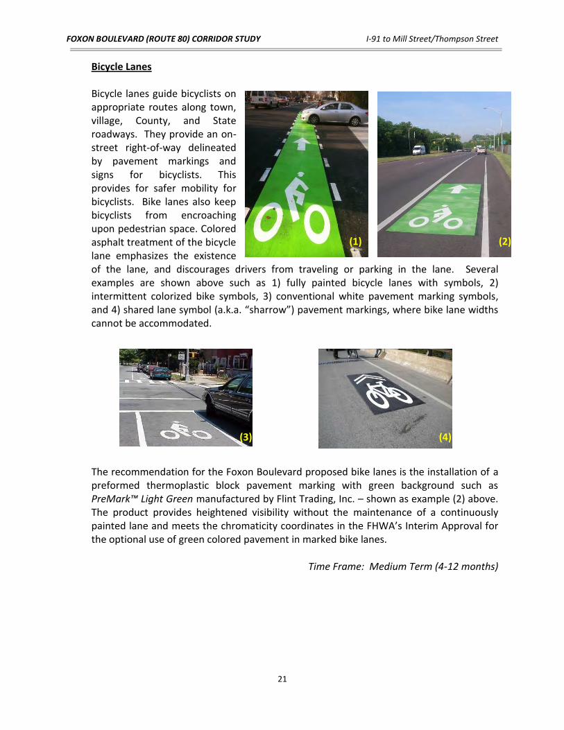
Bicycle Lanes
Bicycle lanes guide bicyclists on appropriate routes along town, village, County, and State roadways. They provide an on-street right-of-way delineated by pavement markings and signs for bicyclists. This provides for safer mobility for bicyclists. Bike lanes also keep bicyclists from encroaching upon pedestrian space. Colored asphalt treatment of the bicycle lane emphasizes the existence of the lane, and discourages drivers from traveling or parking in the lane. Several examples are shown above such as 1) fully painted bicycle lanes with symbols, 2) intermittent colorized bike symbols, 3) conventional white pavement marking symbols, and 4) shared lane symbol (a.k.a. “sharrow”) pavement markings, where bike lane widths cannot be accommodated. The recommendation for the Foxon Boulevard proposed bike lanes is the installation of a preformed thermoplastic block pavement marking with green background such as PreMark™ Light Green manufactured by Flint Trading, Inc. – shown as example (2) above. The product provides heightened visibility without the maintenance of a continuously painted lane and meets the chromaticity coordinates in the FHWA’s Interim Approval for the optional use of green colored pavement in marked bike lanes.
Time Frame: Medium Term (4-12 months)
(1) (2)
(3) (4)

FOXON BOULEVARD (ROUTE 80) CORRIDOR STUDY I-91 to Mill Street/Thompson Street
22
Pedestrian Countdown Signals
Pedestrian signals are used to govern the pedestrian movements at a signalized intersection. (WALK/DON’T WALK lights are being converted statewide to the internationally recognized ‘hand/walk man’ symbol). The steady DON’T WALK or steady hand message indicates when pedestrians should not be in the crosswalk. The flashing DON’T WALK or flashing hand symbol constitutes
the clearance interval, that is, pedestrians should not step into the crosswalk, but they may finish crossing if they are already in the crosswalk (i.e., DON’T START). The WALK or walking man symbol indicates that pedestrians may cross the street in the direction of the signal. Countdown pedestrian signals provide an additional feature, which clearly defines the crossing time for pedestrians. The signal head displays numbers counting down the time (in seconds) remaining to safely cross the road. Countdown signals are typically installed at high pedestrian volume locations (i.e. schools, commercial corridors, or downtown areas).
Time frame: Short Term (1 – 3 months)* *Short term if the construction of additional poles and conduit is not required. Otherwise the time frame is Medium (6 – 12 months)
Curb Cuts and Ramps
The single most common feature employed to improve the mobility of pedestrians, especially those with disabilities is the curb cut. Ramps located in the center of a corner (apex) should be avoided and replaced, if possible. Such locations increase the difficulty for the visually impaired and the wheelchair user to reach and use the crosswalk. Each corner should have two curb cuts (with ADA compliant detectable warning fields), which will dramatically reduce the crossing length for pedestrians in the roadway. Ramps or cut-through islands must be provided on pedestrian refuge islands.
Time frame: Long Term (1 - 3 years)

FOXON BOULEVARD (ROUTE 80) CORRIDOR STUDY I-91 to Mill Street/Thompson Street
23
Continuous Sidewalks
Continuous sidewalks provide a safe means of accessibility for both business and residential destinations. With large segments of Foxon Boulevard lacking sidewalks, current pedestrian access is limited, in particular, within the Town of East Haven. Continuous sidewalks throughout the Foxon Boulevard study corridor would provide a link between both New Haven and East Haven and could potentially spur increased interest by pedestrians to the various shopping centers and businesses along
the corridor, and thereby resulting in less motor vehicle trips. The feasibility of accommodating sidewalks within the existing right-of-way was performed as part of this study. The proposed locations/recommendations based on these constraints are depicted on the Conceptual Design Plans in Appendix B. Further records/deed searches and property line establishment is recommended in the preliminary design phase to define right-of-way, sidewalk width, grading easements, and ability to incorporate a grass buffer/utility strip.
Time frame: Long Term (1 - 3 years)
Raised Medians
Replacing flush medians with raised medians provide increased protection for pedestrians and a separation between opposing vehicular traffic. Low-maintenance medians can generally be constructed of conventional concrete or a highly visible, colored/imprinted concrete with a “brick-like” pattern. Installation typically is performed as part of capital construction programs.
Time frame: Long Term (1 - 3 years)

FOXON BOULEVARD (ROUTE 80) CORRIDOR STUDY I-91 to Mill Street/Thompson Street
24
Gateway
Gateways are geometric or physical landmarks which are often used to indicate a change in environment from a major high speed roadway to a lower speed residential or commercial area. They send a clear message to motorists that they have entered a specific place and should reduce speeds. Gateways also provide a distinct image or setting for an area. They can be used to welcome visitors and create a sense of place. Strong visual effects such as landscaped/planted medians and/or signs are often used to establish gateway areas. A gateway area between Middletown Avenue and the New Haven Shopping center could help calm traffic exiting I-91 to eastbound Foxon Blvd. A gateway in
this area would also provide a sense of change for motorists traveling from the mostly industrial area west of the I-91 interchange, to the shopping district east of the interchange.
Time frame: Long Term (1 - 3 years)
Bus Shelters Bus shelters are enclosed waiting areas that provide
refuge to commuters. In addition, they can be used as a place to provide schedules, bus route maps and advertising which can bring in revenue. Bus shelters can also be designed to accommodate a wide range of aesthetic preferences.
Time frame: Long Term (1 - 3 years) Leading Pedestrian Interval (LPI)
The Leading Pedestrian Interval (LPI) is a signal phase that allows pedestrians to start their crossing generally 5 to 10 seconds prior to the parallel movement of traffic getting a green signal. This minimizes turning movement/pedestrian conflicts by allowing the pedestrian to “take control” of the crosswalk before the driver begins turning. If the “all ped phase” / “Barnes Dance” (i.e. signal phase that allows pedestrians to cross in any direction while all vehicular traffic is stopped) is eliminated in lieu of recommendations such as relocated pedestrian ramps, shorter crosswalks, and need to improve level of service, the LPI can be implemented to provide an added level of protection for pedestrian crossings.
Time frame: Medium Term (6 – 12 months)

FOXON BOULEVARD (ROUTE 80) CORRIDOR STUDY I-91 to Mill Street/Thompson Street
25
CONCEPTUAL DESIGN PLANS In addition to the above general recommendations, the Conceptual Design Plans (Exhibits 1 through 9 in Appendix B) illustrate additional improvements at specific locations within the project corridor. The following summary presents an outline of these recommendations, potential issues as well as feedback from the public regarding specific improvements. Elimination of Slip Ramps at Middletown Avenue and the I-91 Interchange
As discussed with the City of New Haven, a redesign of the existing I-91 off-ramp to eastbound Foxon Boulevard is currently being investigated by the Connecticut Department of Transportation. Based on discussions at the Foxon Boulevard Study stakeholder meetings, it was suggested the existing slip ramps on Foxon Boulevard to and from I-91 and Middletown Avenue be eliminated in lieu of a potential reconfigured design of the ramps/roadway intersecting Foxon Boulevard. The purpose of this potential redesign is to reduce the speed of traffic exiting/entering I-91 and Middletown Avenue via the existing slip ramps and to provide shorter, more pedestrian and bicycle-friendly crossings at these intersections. Removal of the existing slip ramps and their associated acceleration/deceleration lanes on Foxon Boulevard would also aid in calming traffic on Foxon Boulevard, in particular the movement at the I-91 off-ramp to eastbound Foxon Boulevard. Based on the number of rear-end accidents in the eastbound direction between Middletown Avenue and Quinnipiac Avenue as well as the observed speed of vehicles exiting the ramp to eastbound Foxon Boulevard, removal of the existing slip ramp and deceleration lane would slow vehicles that would otherwise continue traveling at near interstate-level speeds on the approach to the New Haven Plaza shopping center. (See Conceptual Design - Exhibit 1 in Appendix B)
Further Studies The above changes would require a detailed traffic analysis of the I-91 interchange and Middletown Avenue at Foxon Boulevard. As traffic analyses were not included in this report, the overall impact to the level of service, queuing and delay to vehicles on Foxon Boulevard, the I-91 northbound off-ramp and Middletown Avenue, by removing the slip ramps, is not fully known.
Landscaped/Planted Medians between Middletown Avenue and the New Haven Plaza Shopping Center
The conceptual design plans call for a landscaped/planted median between Dump Road and the New Haven Plaza shopping center. In addition to the aesthetic “gateway” effect these types of medians can offer, they can also be used to prevent motorists from making illegal left turns. Left turn movements, in particular from vehicles exiting businesses along

FOXON BOULEVARD (ROUTE 80) CORRIDOR STUDY I-91 to Mill Street/Thompson Street
26
the Foxon Boulevard study corridor, can be especially dangerous given the need for motorists to cross as much as three lanes of traffic plus an additional turn lane. The proposed medians shown on the conceptual plans within the vicinity of the New Haven Plaza shopping center are not designed to hinder vehicles from accessing businesses along Foxon Boulevard, but to serve as a means to organize and delineate the roadway making it safer for the traveling public. The design promotes the use of existing signalized intersections and cross-access between the commercial businesses. (See Conceptual Design - Exhibits 1 & 2 in Appendix B)
Potential Issues The median proposed directly in front of the existing car wash (adjacent to the New Haven Plaza shopping center) would prevent vehicles exiting the car wash from making left turns to travel westbound on Foxon Boulevard. However, the owner of the car wash facility has expressed concerns of the potential impact to his business as the length of the westbound left turn lane on Foxon Boulevard, which provides access to his business, would be reduced due to the median. In addition, he has also expressed concern regarding the blocking of left turn movements for vehicles exiting his business due to the median.
As discussed at stakeholder meetings for this project, the optimal goal for vehicles exiting the car wash as well as the adjacent McDonald’s restaurant, wanting to make left turns onto Foxon Boulevard, would be to direct them to the signalized intersection at the main entrance to the New Haven Plaza shopping center. Existing driveway cross-connections are currently available, which allow access between the car wash and McDonald’s and from McDonalds to the rest of the shopping center. The legalities of these connections as well as possible additional connections to the shopping center would need to be further investigated during the preliminary design phase for such improvements.
Sidewalk Connection to Foxon Blvd. from Barnes Avenue
A proposed sidewalk connection between Barnes Avenue and the north side of Foxon Boulevard would provide a link to the communities north of the project corridor, between Middletown Avenue and Quinnipiac Avenue, to the various businesses along Foxon Boulevard. Residents along or north of Barnes Avenue would have the option to walk to these businesses instead of driving to them with the installation of this new sidewalk link. (See Conceptual Design - Exhibit 3 in Appendix B)
Potential Issues This sidewalk would be constructed on school property which is owned by the City of New Haven. Due to significant grade differences between the north side of Foxon Blvd and the school property grading of the sidewalk would need to be analyzed during final design.

FOXON BOULEVARD (ROUTE 80) CORRIDOR STUDY I-91 to Mill Street/Thompson Street
27
Sidewalk Along the South Side of Foxon Blvd. East of Old Foxon Road
The conceptual plans propose a single sidewalk along the north side of Foxon Boulevard between Old Foxon Road (in New Haven) and Foxon Boulevard side street (in East Haven). New high visibility crosswalks would allow pedestrians to cross Foxon Boulevard (Route 80) at Old Foxon Road (in New Haven) and at Foxon Boulevard side street (in East Haven), which are both signalized intersections. The reason there is a proposed sidewalk only on the north side of the road in this area is due to the limited horizontal width between the existing buildings fronting Foxon Boulevard between Rose Street and Old Foxon Road. The approximate available width (73’), from building face to building face, is not wide enough to accommodate five 11’ lanes of traffic, two 5’ wide bicycle lanes and two 5’ wide sidewalks (75’). Due to this horizontal constraint as well as the greater presence of businesses along the north side of Foxon Boulevard in this area, the Conceptual Design proposes one sidewalk along the north side of the road while maintaining the proposed two (5’ wide) bicycle lanes throughout the corridor. (See Conceptual Design - Exhibits 5 & 6 in Appendix B)
Potential Issues During the public meeting held on June 26th, 2012 a resident expressed concern regarding the absence of sidewalk along the south side of Foxon Boulevard in this area of the project. In order to provide sidewalks on both sides of the road, in particular between Rose Street and Old Foxon Road, at least one of the bicycle lanes would need to be eliminated. One option that could be considered would be to replace one or both of the bicycle lanes with a wide curbside travel lane (14’ wide right lane) with shared-use bicycle symbol (i.e. sharrow).
Continuation of Bicycle Lanes Beyond Project Limits
It should be noted that the on-road bicycle lanes/route can be extended beyond the study limits on Foxon Boulevard to the east within the Town of East Haven and to the southwest in the City of New Haven with minimal improvements required. A wide shoulder currently exists on Foxon Boulevard east of Mill Street/Thompson Street, which can accommodate a full bike lane. The corridor east of the study limits can be designated as a Class II, on-road, bicycle facility with the installation of bike symbols within the shoulder area and associated “Bike Lane” signage or as a Class III, on-road, bike route with the installation of “Bike Route” signage.
In the City of New Haven, the adjacent segment of Middletown Avenue west of Foxon Boulevard generally exhibits a varying shoulder lane that can accommodate either a bike lane or bike route with proper pavement markings and signage. The nearest on-road bicycle facility is a Class III, Shared Roadway on Middletown Avenue at Front Street approximately one-mile southwest of Foxon Boulevard’s western terminus at Interstate 91. The existing bike route meanders around the City, connects to other designated on-

FOXON BOULEVARD (ROUTE 80) CORRIDOR STUDY I-91 to Mill Street/Thompson Street
28
road road bike routes, and leads into the downtown center of the City. If such connections are made with the proposed Foxon Boulevard improvements, a significant bicycle facility link of over 2.5 miles can be added to the City’s current network.
VII. PROJECT COST AND SCHEDULE
This study revealed various safety concerns and recommended several pedestrian facility enhancements and safety improvements, which could be implemented as part of future capital improvement programs contingent upon available funding. At this time, there are no significant factors based on the study findings that require immediate attention. Continued, routine, roadway maintenance and infrastructure upgrades, specifically traffic signals, handicap ramps, and sidewalk network expansion are recommended, as indicated in this report for ongoing upkeep and improvement of the corridor.
The construction costs associated with the potential capital improvements as described in this report and illustrated on the Conceptual Design Plans are estimated at $3,900,000, which includes continuous bike lanes, construction of a complete sidewalk network, replacement of existing traffic signals, introduction of localized raised medians, modified lane delineation and geometry, new signage and pavement markings. No property acquisitions are required for the proposed enhancements. An itemized Conceptual Cost Estimate is provided in Appendix E.
At the conclusion of this study there is no timetable for implementation of proposed
improvements. The South Central Regional Council of Governments will discuss with the City of New Haven, Town of East Haven, and ConnDOT the efficacy of the improvements explored in this study and need for further detailed analyses. At the time of those discussions, a project schedule will be developed for any future capital improvements.