Embed Size (px)
Citation preview

7.2.2.3 Bracken Ridge and district neighbourhood plan code
7.2.2.3.1 Application
(1) This code applies to assessing a material change of use, reconfiguring a lot, operational work or building work in the Bracken Ridge and district neighbourhood plan area if:
(a) assessable development where this code is an applicable code identified in the assessment criteria column of a table of assessment for a neighbourhood plan (section 5.9); or
(b) impact assessable development.
(2) Land in the Bracken Ridge and district neighbourhood plan area is identified on the NPM-002.3 Bracken Ridge and district neighbourhood plan map and includes the following precincts:
(a) Carseldine residential precinct (Bracken Ridge and district neighbourhood plan/NPP-001);
(b) Bridgeman Downs residential precinct (Bracken Ridge and district neighbourhood plan/NPP-002);
(c) Taigum residential precinct (Bracken Ridge and district neighbourhood plan/NPP-003);
(d) West Aspley residential precinct (Bracken Ridge and district neighbourhood plan/NPP-004);
(e) Relocatable home parks precinct (Bracken Ridge and district neighbourhood plan/NPP-005);
(f) Bracken Ridge east precinct (Bracken Ridge and district neighbourhood plan/NPP-006);
(g) Bald Hills village centre precinct (Bracken Ridge and district neighbourhood plan/NPP-007);
(h) Zillmere industrial precinct (Bracken Ridge and district neighbourhood plan/NPP-008);
(i) Gawain Road centre precinct (Bracken Ridge and district neighbourhood plan/NPP-009);
(j) Bald Hills/Bridgeman Downs precinct (Bracken Ridge and district neighbourhood plan/NPP-010);
(k) Bridgeman Downs precinct (Bracken Ridge and district neighbourhood plan/NPP-0011);
Part 7 – Neighbourhood plans (Bracken Ridge) Effective X
(l) North Bald Hills precinct (Bracken Ridge and district neighbourhood plan/NPP-012);
(m) Bracken Ridge Road precinct (Bracken Ridge and district neighbourhood plan/NPP-013);
(n) North Bracken Ridge precinct (Bracken Ridge and district neighbourhood plan/NPP-014);
(o) Zillmere centre precinct (Bracken Ridge and district neighbourhood plan/NPP-0015).
Editor's note–Part of the neighbourhood plan area is covered by the Fitzgibbon priority development area which Economic Development Queensland is responsible for planning under the Economic Development Act 2012.
(3) When using this code, reference should be made to section 1.5, section 5.3.2 and section 5.3.3.
Note—This neighbourhood plan includes a table of assessment with level of assessment variations to those in sections 5.5, 5.6, 5.7, 5.8 and 5.10. Refer to Table 5.9.9.A, Table 5.9.9.B, Table 5.9.9.C, and Table 5.9.9.D.
7.2.2.3.2 Purpose
(1) The purpose of the Bracken Ridge and district neighbourhood plan code is to provide finer grained planning at a local level for the Bracken Ridge and district neighbourhood plan area.
(2) The purpose of the Bracken Ridge district neighbourhood plan code will be achieved through overall outcomes including overall outcomes for each precinct of the neighbourhood plan area.
(3) The overall outcomes for the neighbourhood plan area are:
(a) Development creates functional and integrated communities.
(b) Land subject to development constraints or character or environmental values indicated in a figure in this neighbourhood plan code or shown on an overlay map is protected from inappropriate development to maintain its character, natural and ecological significance.
(c) Development protects and enhances biodiversity, native habitat and fauna movement.
(d) Open space, parks and recreational facilities meet the needs of the community and are located in accessible locations that are well connected within the neighbourhood plan area.
(e) Development in a potential development area addresses the location of the land, availability of services, environmental constraints, amenity, and existing patterns of development, to ensure an integrated development outcome.
Part 7 – Neighbourhood plans (Bracken Ridge) Effective X

(f) Residential development provides for a mix of housing types, styles and densities.
Note—Densities and yields are to be calculated excluding parts of the site that are not within a potential development area. These include areas with development constraints or character or environmental values identified in overlay maps. Yields and maximum gross floor area for multiple dwellings and dual occupancy are to be calculated across the potential development area including all access ways and roads respectively.
(g) Pedestrian and cyclist paths provide safe and legible connections between residential areas and key destinations including centres, community facilities, major parks and conservation reserves, and public transport nodes.
(h) Development is of a height, scale and form which is consistent with the amenity and character, community expectations and infrastructure assumptions intended for the relevant precinct, sub-precinct or site and is only developed at a greater height, scale and form where there is both a community need and economic need for the development.
(4) Carseldine residential precinct (Bracken Ridge and district neighbourhood plan/NPP-001) overall outcome is:
(a) Development in the Emerging community zone between Gympie Road and Dorville Road is for residential uses in accordance with Figure b.
(5) Bridgeman Downs residential precinct (Bracken Ridge and district neighbourhood plan/NPP-002) overall outcomes are:
(a) Development in the Emerging community zone is in accordance with Figure c.
(b) Reconfiguring a lot in the Emerging community zone in Retreat Street is undertaken in an orderly manner to facilitate the transition from rural to higher intensity allotments consistent with the Rural residential zone.
(c) Minimum allotment sizes of 2,500m2 are provided on land identified in Figure c.
(6) Taigum residential precinct (Bracken Ridge and district neighbourhood plan/NPP-003) overall outcomes are:
(a) Development in the Emerging community zone is in accordance with Figure d.
(b) Future development of the retirement facility land on Handford Road and Roghan Road includes a public road that allows for integration with the surrounding community including access to community services, shopping and other facilities.
(c) A neighbourhood centre is intended at the junction of Handford Road and Roghan Road to serve the retail, commercial, entertainment, community uses and other needs of the local community.
(d) Business and centre activities do not expand outside of this identified neighbourhood centre.
Part 7 – Neighbourhood plans (Bracken Ridge) Effective X

(e) Retirement facilities are located along significant public transport routes near the Taigum centre.
(f) Multiple dwellings are accommodated within the precinct and may be up to 5 storeys where located on sites greater than 1.5ha and building siting, landscaping, vehicle movements and the relationship to adjacent sites can be effectively managed. Refer to figure d.
(7) West Aspley residential precinct (Bracken Ridge and district neighbourhood plan/NPP-004) overall outcome is:
(a) The precinct has well-integrated low density residential development that protects and enhances the environmental and recreation values of Cabbage Tree Creek. Refer to Figure e.
(8) Relocatable home parks precinct (Bracken Ridge and district neighbourhood plan/NPP-005) overall outcomes are:
(a) Relocatable home parks that provide affordable housing and short-term tourist accommodation remain in this precinct.
(b) Redevelopment for other than relocatable home parks uses includes affordable housing for low-income households.
(9) Bracken Ridge east precinct (Bracken Ridge and district neighbourhood plan/NPP-006) overall outcome is:
(a) Development protects habitat and biodiversity values including wetland and waterway corridors that support fauna movement from the Deagon wetlands to Cabbage Tree Creek.
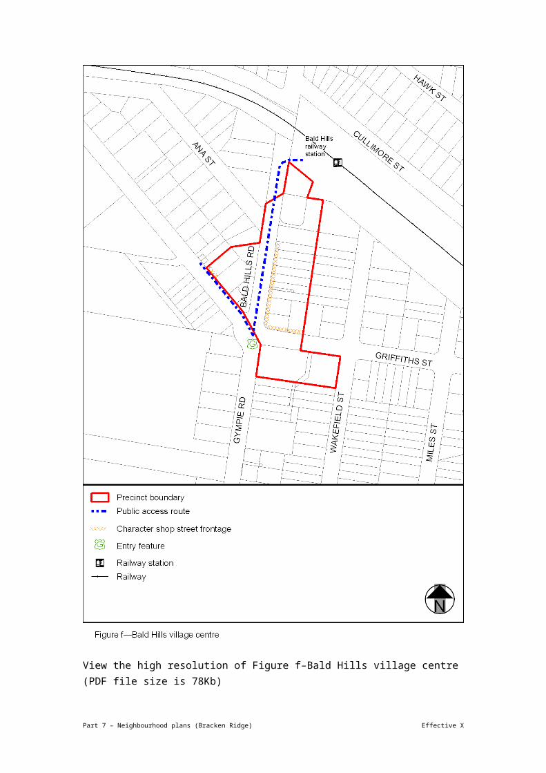
(10) Bald Hills village centre precinct (Bracken Ridge and district neighbourhood plan/NPP-007) overall outcomes are:
(a) Bald Hills village functions as a neighbourhood centre catering for the convenience, service, hotel and food and drink outlet needs of the community.
(b) The centre includes a safe, pedestrian-friendly street shopping environment and places for people to meet and interact.
(c) Development is contained within the existing village centre boundary, minimises impacts on surrounding residential amenity and maintains and enhances the existing character streetscape.
(11) Zillmere industrial precinct (Bracken Ridge and district neighbourhood plan/NPP-008) overall outcomes are:
(a) This precinct provides a source of local employment through industry activities.
Part 7 – Neighbourhood plans (Bracken Ridge) Effective X

(b) Industrial development and associated activities are managed to mitigate impacts on residents in the surrounding area.
(c) The State Government is encouraged to complete the pedestrian and cycle access link between Carseldine and Zillmere railway stations in future development of the State-controlled land in Pineapple Street.
(12) Gawain Road centre precinct (Bracken Ridge and district neighbourhood plan/NPP-009) overall outcomes are:
(a) This precinct functions as a neighbourhood centre catering for the needs of the local community.
(b) Development of the centre is contained within the existing centre.
(c) Development minimises impacts on surrounding residential amenity, and maintains and enhances the existing low density residential streetscape.
(d) Development provides a safe, pedestrian-friendly street shopping environment that is well connected to Harold Dean Park and provides spaces that support social interaction and community uses.
(e) The precinct includes a mix of centre activities and community facilities along with multiple dwellings that can provide for a variety of housing options.
(13) Bald Hills/Bridgeman Downs precinct (Bracken Ridge and district neighbourhood plan/NPP-010) overall outcomes are:
(a) Areas of unserviced land in Bald Hills and Bridgeman Downs as indicated in Figure a do not accommodate urban development until such time as the Pine Rivers North and Pine Rivers South key resource areas (KRA 59 and KRA 60 respectively) are amended or deleted from the SPP Guideline, State interest—mining and extractive resources, Key Resource Area maps.
Note—Refer to the Extractive resources overlay code for details of separation areas and buffers that apply to provide a suitable distance between incompatible uses to ameliorate impacts.
(b) No development than otherwise permitted in the Rural zone will be supported until flooding impacts, local infrastructure provision and biodiversity issues have been sufficiently resolved through a comprehensive structure plan that addresses the following elements:
(i) provision of a road network that is interconnected with the established road hierarchy and minimises the number of vehicular entry points to Linkfield Connection Road, Millar Road, Carseldine Road and Gympie Road;
Part 7 – Neighbourhood plans (Bracken Ridge) Effective X

(ii) provision of pedestrian and bicycle pathway connections to local destinations including the Bald Hills railway station to the north and recreation and sporting facilities to the east;
(iii) connection to the Cabbage Tree Creek sewerage catchment system using gravity feed without relying on pressurised sewer pipelines;
(iv) an interface between land to be developed and land to be conserved as open space that is delineated by a public road allowing for surveillance opportunities and enhanced public safety;
(v) development outcomes that are compatible with established uses and do not result in increased hazard risk;
(vi) provision of a corridor link along the South Pine River catchment that contributes to community life and identity with the provision of conveniently located active open space and recreation opportunities, including pedestrian paths and bikeways and that actively manages waterway corridors, wetlands and vegetation areas.
Note—A structure plan prepared in accordance with the Structure planning planning scheme policy can assist in demonstrating achievement of this overall outcome.
(14) Bridgeman Downs precinct (Bracken Ridge and district neighbourhood plan/NPP-011) overall outcomes are:
(a) Areas of unserviced land in Bridgeman Downs as shown in Figure a do not accommodate urban development other than that permitted in the Rural zone until the land is adequately serviced.
(b) Development preserves and enhances waterway corridors, locally significant habitat and biodiversity values, native vegetation and productive agricultural land.
(15) North Bald Hills precinct (Bracken Ridge and district neighbourhood plan/NPP-012) overall outcome is:
(a) No development than is otherwise permitted in the Rural zone is accommodated due to a lack of infrastructure.
(16) Bracken Ridge Road precinct (Bracken Ridge and district neighbourhood plan/NPP-013) overall outcomes are:
(a) This precinct is to be redeveloped for low density residential uses in accordance with Figure h.
(b) A sport and recreation area is located at the eastern end of the precinct to cater for a range of sporting activities, in accordance with Figure h.
Part 7 – Neighbourhood plans (Bracken Ridge) Effective X

(c) Development provides a landscaped buffer to the Gateway Motorway and Tinchi Tamba Wetlands and adequately mitigates noise impacts generated by the Gateway Motorway.
(d) Council-owned land at 401 Bracken Ridge Road being part of Lot 194 on RP208282 is potentially developable in conjunction with adjoining lots.
(17) North Bracken Ridge precinct (Bracken Ridge and district neighbourhood plan/NPP-014) overall outcomes are:
(a) The area immediately to the east of Bald Hills Creek sited between Forestlea Street and the Tinchi Tamba Wetlands serves as a buffer between residential development and the Tinchi Tamba Wetlands, in accordance with Figure i.
(b) Only uses that align with the Rural zone criteria for this area are accommodated. No further reconfiguration or development of other urban uses occurs in this part of the precinct due to constraints including flooding, environmental values, waterway corridors and proximity to the Gateway Motorway.
(c) Development in the emerging community development area located between Rainwood Street and the Gateway Motorway is in accordance with Figure i and includes a landscape buffer to the Gateway Motorway and mitigates noise impacts generated by the Gateway Motorway.
(18) Zillmere centre precinct (Bracken Ridge and district neighbourhood plan/NPP-015) overall outcomes are:
(a) Development provides ground-level active frontages with visual connections between interior and outdoor spaces such as shop entrances and display windows and incorporates attractive landscaping, lighting and pedestrian shelter such as awnings.
(b) Existing traditional building facades along street frontages are maintained.
(c) Development west of Handford Road incorporates ‘timber and tin’ materials and is designed to complement the established traditional character of the area.
(d) Development is designed to complement the use of the centre for special events, and building design, orientation and landscaping of corner sites on the intersection of Zillmere Road and Handford Road contribute to the visual significance of this intersection.
(e) Combined pedestrian and vehicular shared spaces, as shown in Figure j, are located off the public street network and include car parking areas, driveways and pedestrian-friendly environments that effectively integrate with centre development.
Part 7 – Neighbourhood plans (Bracken Ridge) Effective X

(f) Clearly legible pedestrian links such as laneways or arcades are well integrated within the centre in order to connect combined pedestrian and vehicular spaces to Zillmere Road and Handford Road, in accordance with Figure j.
7.2.2.3.3 Assessment criteria
The following table identifies the assessment criteria for assessable development.
Table 7.2.2.3.3.A—Criteria for assessable development
Performance outcomes Acceptable outcomes
General
PO1
Development is of a height, scale and form that achieves the intended outcome for the precinct, improves the amenity of the neighbourhood plan area, contributes to a cohesive streetscape and built form character and is:
(a) consistent with the anticipated density and assumed infrastructure demand;
(b) aligned to community expectations about the number of storeys to be built;
(c) proportionate to and commensurate with the utility of the site area and frontage width;
(d) designed so as not to cause a significant and undue adverse amenity impact to adjoining development;
(e) sited to enable existing and future buildings to be well separated from each other and to not prejudice the development of an adjoining site.
Note—Development that exceeds the intended number of storeys or building height can place disproportionate pressure on the transport network, public space or community facilities in particular.
Note—Development that is over-scaled for its site can result in an undesirable dominance of vehicle access, parking and manoeuvring areas that significantly reduce streetscape character and amenity.
AO1
Development complies with the number of storeys and building height in Table 7.2.2.3.3.B.
Note—Neighbourhood plans will mostly specify a maximum number of storeys where zone outcomes have been varied in relation to building height. Some neighbourhood plans may also specify height in metres. Development must comply with both parameters where maximum number of storeys and height in metres are specified.
If in the Bald Hills village centre precinct (Bracken Ridge and district neighbourhood plan/NPP-007)
Part 7 – Neighbourhood plans (Bracken Ridge) Effective X

PO2
Development in a centre ensures built form is consistent with the commercial built form of a traditional suburban street, remains compact and walkable, and ensures integration with the surrounding residential areas and links to public transport.
AO2.1
Development is in accordance with Figure f.
AO2.2
Development provides a building form which includes:
(a) a sufficient pedestrian pavement width consistent with existing development to allow on-street activity;
(b) awning structures provided over pedestrian footpaths;
(c) buildings sited on the front property alignment facing the road.
If in the Carseldine residential precinct (Bracken Ridge and district neighbourhood plan/NPP-001), Bridgeman Downs residential precinct (Bracken Ridge and district neighbourhood plan/NPP-002), Taigum residential precinct (Bracken Ridge and district neighbourhood plan/NPP-003), West Aspley residential precinct (Bracken Ridge and district neighbourhood plan/NPP-004), Bracken Ridge east precinct (Bracken Ridge and district neighbourhood plan/NPP-006), Bracken Ridge Road precinct (Bracken Ridge and district neighbourhood plan/NPP-013) or the North Bracken Ridge precinct (Bracken Ridge and district neighbourhood plan/NPP-014)
PO3
Development for residential uses integrates and connects with surrounding communities and where containing habitat and biodiversity values facilitates fauna movements through the area.
A03
Development within the each precinct is consistent with the following:
(a) Carseldine residential precinct (Bracken Ridge and district neighbourhood plan/NPP-001) – Figure b;
(b) Bridgeman Downs residential precinct (Bracken Ridge and district neighbourhood plan/NPP-002) – Figure c;
(c) Taigum residential precinct (Bracken Ridge and district neighbourhood plan/NPP-003) – Figure d;
(d) West Aspley residential precinct (Bracken Ridge and district neighbourhood plan/NPP-004) – Figure e;
(e) Bracken Ridge Road precinct (Bracken Ridge and district neighbourhood plan/NPP-0013) – Figure h;
(f) North Bracken Ridge precinct (Bracken Ridge and district neighbourhood plan/NPP-0014) – Figure i.
Part 7 – Neighbourhood plans (Bracken Ridge) Effective X

PO4
Development must utilise established district sewerage infrastructure.
AO4
Development is designed and constructed to access the existing Cabbage Tree Creek sewerage system via gravity feed.
If in the Taigum residential precinct (Bracken Ridge and district neighbourhood plan/NPP-003) in the Emerging community zone;
(a) for a multiple dwelling;
(b) on a site 15,000m2 or greater in area;
PO5
Development size and bulk:
(a) results in a low–medium to medium density building form that integrates with the established built form and minimises impacts, including overshadowing and overlooking on adjoining low and low–medium density developments;
(b) maintains a low to low–medium density streetscape.
AO5.1
Development has a maximum gross floor area of 80% of the site area.
AO5.2
Development provides a landscape buffer that is planted with advanced species along boundaries to an adjoining site that has been developed at a lower building height.
If in the Bracken Ridge Road precinct (Bracken Ridge and district neighbourhood plan/NPP-013), where in the Sport and recreation zone and for indoor sport and recreation
PO6
Development must provide adequate visual screening to adjoining residential areas and to the Gateway Motorway.
AO6.1
Development provides a landscape buffer of 3m along the common boundary with residential uses.
AO6.2
Development provides a landscape buffer of 6m along the site boundary to the Gateway Motorway.
If in the Relocatable home parks precinct (Bracken Ridge and district neighbourhood plan/NPP-005), where involving the removal of a relocatable home and on a site indicated in Figure a, Figure d and Figure g
PO7
Development must address and mitigate the social and health impacts created by the removal of the relocatable home.
Note—A social health impact assessment report prepared in accordance with the Social health impact assessment planning scheme policy can assist in demonstrating
AO7
No acceptable outcome is prescribed.
Part 7 – Neighbourhood plans (Bracken Ridge) Effective X

achievement of this outcome.
Table 7.2.2.3.3.B—Maximum building height
Development Building height (number of storeys)
Building height (m)
Underside eaves height (m)
If in the Bald Hills village centre precinct (Bracken Ridge and district neighbourhood plan/NPP-007)
Any development in this precinct. 3 Not specified
Not specified
If in the Taigum residential precinct (Bracken Ridge and district neighbourhood plan/NPP-003)
Development for a multiple dwelling in the Emerging community zone, where on a site 15,000m2 or greater in area and identified as Multiple dwellings (to 5 storeys) in Figure d.
2 storeys where adjoining 1 storey residential uses and within 10m of side or rear boundaries
Not specified
Not specified
3 storeys where adjoining 2 storey residential uses and within 10m of side or rear boundaries
Not specified
Not specified
5 at the centre of the site
16 at the centre of the site
Not specified
2 at the street frontage
Not specified
Not specified
If in the Gawain Road centre precinct (Bracken Ridge and district neighbourhood plan/NPP-009)
Part 7 – Neighbourhood plans (Bracken Ridge) Effective X

Development of a multiple dwelling in the Neighbourhood centre zone
3 storeys where a minimum of 2 storeys are for residential uses
Not specified
9.5
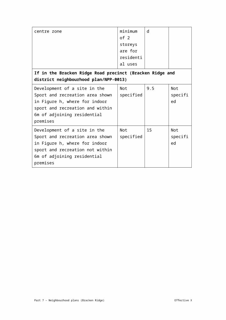
If in the Bracken Ridge Road precinct (Bracken Ridge and district neighbourhood plan/NPP-0013)
Development of a site in the Sport and recreation area shown in Figure h, where for indoor sport and recreation and within 6m of adjoining residential premises
Not specified 9.5 Not specified
Development of a site in the Sport and recreation area shown in Figure h, where for indoor sport and recreation not within 6m of adjoining residential premises
Not specified 15 Not specified
Part 7 – Neighbourhood plans (Bracken Ridge) Effective X

View the high resolution of Figure a–Development intent areas (PDF file size is 719Kb)
Part 7 – Neighbourhood plans (Bracken Ridge) Effective X

View the high resolution of Figure b–Carseldine residential precinct (PDF file size is 179Kb)
Part 7 – Neighbourhood plans (Bracken Ridge) Effective X

View the high resolution of Figure c–Bridgeman Downs residential precinct (PDF file size is 161Kb)
Part 7 – Neighbourhood plans (Bracken Ridge) Effective X
View the high resolution of Figure d–Taigum residential precinct (PDF file size is 278Kb)
Part 7 – Neighbourhood plans (Bracken Ridge) Effective X

View the high resolution of Figure e–West Aspley residential precinct (PDF file size is 202Kb)
Part 7 – Neighbourhood plans (Bracken Ridge) Effective X

View the high resolution of Figure f–Bald Hills village centre (PDF file size is 78Kb)
Part 7 – Neighbourhood plans (Bracken Ridge) Effective X

View the high resolution of Figure g–Zillmere industrial precinct (PDF file size is 203Kb)
Part 7 – Neighbourhood plans (Bracken Ridge) Effective X

View the high resolution of Figure h–Bracken Ridge Road precinct (PDF file size is 154Kb)
Part 7 – Neighbourhood plans (Bracken Ridge) Effective X

View the high resolution of Figure i–North Bracken Ridge precinct (PDF file size is 172Kb)
Part 7 – Neighbourhood plans (Bracken Ridge) Effective X
View the high resolution of Figure j–Zillmere centre precinct (PDF file size is 81Kb)
Part 7 – Neighbourhood plans (Bracken Ridge) Effective X