Embed Size (px)
Citation preview

Follow Massachusetts Historical Commission Survey Manual instructions for completing this form.
FORM B BUILDING
MASSACHUSETTS HISTORICAL COMMISSIONMASSACHUSETTS ARCHIVES BUILDING220 MORRISSEY BOULEVARDBOSTON, MASSACHUSETTS 02125
Photograph
Topographic or Assessor's Map
Recorded by: Jon Buono
Organization: EYP/ Architecture & Engineering
Date (month / year): August 2008
Assessor’s Number USGS Quad Area(s) Form Number
UMASS No. 124 Williamsburg n/a
Town: Amherst
Place: (neighborhood or village) University ofMassachusetts
Address: 666 North Pleasant St.
Historic Name: Hasbrouck Laboratory
Uses: Present: Academic
Original: “Physics Building”
Date of Construction: 1950
Source: construction documents (1947) UMASS Facilities OfficeStyle/Form: Modern Classic
Architect/Builder: Kilham Hopkins Greeley
Exterior Material:Foundation: concrete
Wall/Trim: brick running bond, glass block
Roof: copper, segmented-dome
Outbuildings/Secondary Structures:none
Major Alterations (with dates):Major addition at south, 1961
Condition: good to fair
Moved: no | X | yes | | Date
Acreage: 1,348 acres 2008 historic structure surveyarea
Setting: Hasbrouck Laboratory is located to the eastof Lincoln Campus Center on a flat site that fronts the westside of North Pleasant Street. On the east side of thebuilding is a bituminous concrete walkway that runs thelength of the building. Between the walk and the building ismown lawn. Foundation plantings at the building includeevergreen and deciduous trees, evergreen shrubs, andperennials. On the west side of the building is a bituminousdrive and parking area with lawn and deciduous treeslocated beyond, further to the west.

INVENTORY FORM B CONTINUATION SHEET [AMHERST] [666 NORTH PLEASANT ST. ]
MASSACHUSETTS HISTORICAL COMMISSION Area(s) Form No.220 MORRISSEY BOULEVARD, BOSTON, MASSACHUSETTS 02125
Continuation sheet 1
n/a
_X__ Recommended for listing in the National Register of Historic Places.If checked, you must attach a completed National Register Criteria Statement form.
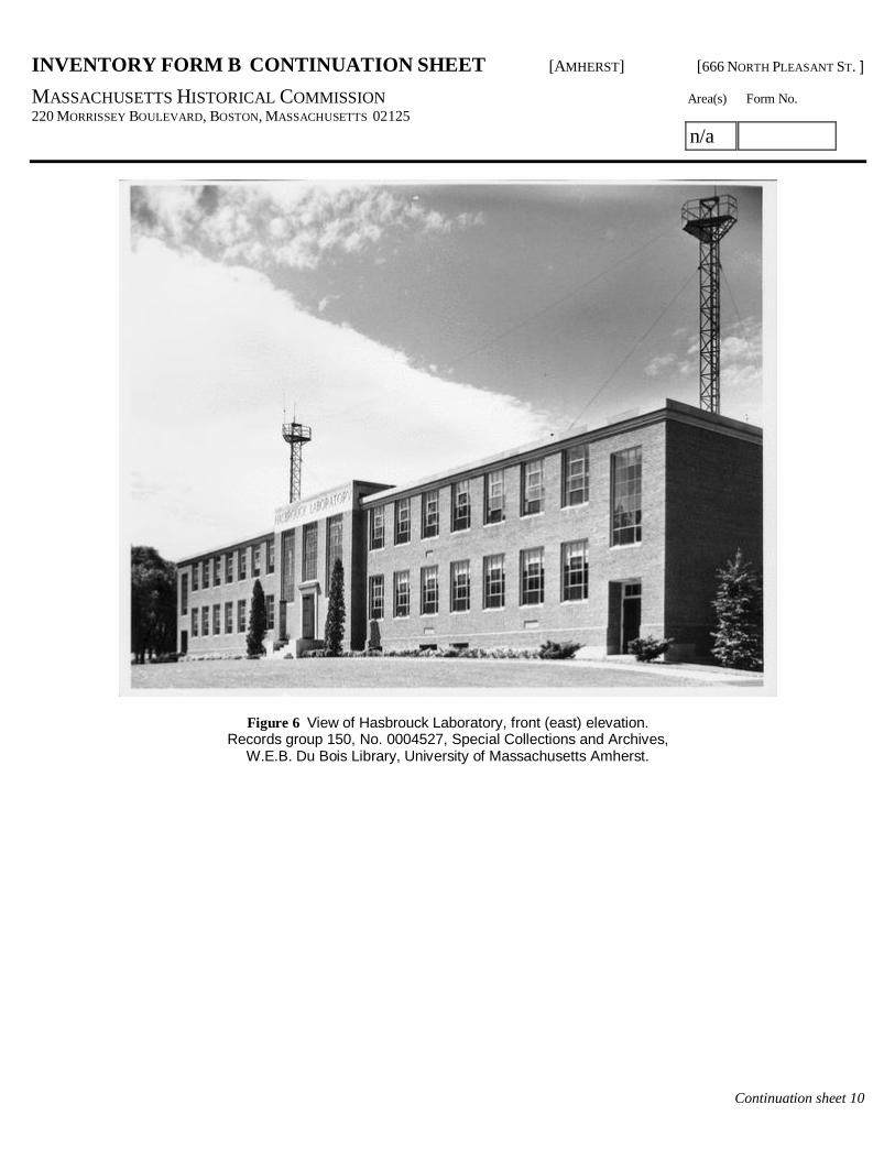
ARCHITECTURAL DESCRIPTION:Hasbrouck Laboratory is located on the west side of North Pleasant Street and is oriented on a north-south axis with the easternfaçade being the street facade. It is a two-story flat-roofed brick building with wings extending out from a three bay wideprojecting entry. The brickwork is laid in a common bond pattern with 6th course Flemish headers and includes an ogee shapedbrick water table that extends across the eastern façade at the level of the first floor. Brick continues below the water table tograde with small areas of exposed concrete foundation visible.
The central entry has Art Deco detailing and is characterized by a flush limestone frieze with the words “Hasbrouck Laboratory”inscribed. Two large five light wide by eight pane high steel windows flank the main entrance with a five light wide by six panehigh steel window is located above the entrance. Each of the windows has a limestone sill. The area below the side windowshas decorative brickwork set in a Flemish bond from the sill to the brick water table.
The main entry doors are modern aluminum replacement doors with transom and sidelights set into the original limestonearchitrave. The entry is six steps above grade with a granite landing and steps flanked by limestone cheek walls. At the frontcorner of each cheek wall is an original aluminum lighting fixture resembling fasces.
At the southern end of the south wing and the northern end of the north wing there are painted flush hollow metal-exit doorsleading from fire stairs within. Above each door is a large four pane wide by six pane high steel window with the lowest twopanes acting as a ventilator window. From there to the center three-bay entry are seven four pane wide by four pane high steelwindows at both the first and second floor levels. Each window has three operable awning sash which incorporate the center twopanes of the window. The uppermost pair is not operable. Located vertically between the water table and the first floor windows,and between the first and second floor windows, there is a decorative Flemish bond panel of brickwork. There is a limestonecoping at the top of the walls.
There are several louvers at the basement level on the eastern façade which have concrete areaways.
On the north façade there is a single window at the center of the first and second floor levels and a center entry door with awindow to its west at the basement level.
At the rear, or western façade, the building is symmetrical about a large three-story round tower which is half engaged into theplan. The tower is surmounted by a copper sloped octagonal roof. The tower projects above the flat roof of the rest of thebuilding. The space within the tower contains a library and lecture room. It has glass block windows in the clerestory area abovethe adjacent roof and six-pane wide by four- pane high steel windows at the second floor level. There are no windows in thetower at the first floor level. There are four-pane wide by four-pane high steel windows at the basement level of the tower.
Flanking the center tower on the western façade the north and south wings each have seven bays of steel windows at thebasement, first and second floor levels. There are exit doors located in the bay closest to the tower at the basement level. Thesewindows are identical to those on the eastern façade except that the windows above the basement exit ways are six panes wideby four panes high.
HISTORICAL NARRATIVE
OverviewThe University of Massachusetts, Amherst was chartered as the Massachusetts Agricultural College in 1863 but did not acceptits first class until 1867. As one of two land grant universities in Massachusetts, the university’s original mission was agriculturaleducation. Its mission, however, evolved within the first 20 years in response to the changing needs of the United States. While

INVENTORY FORM B CONTINUATION SHEET [AMHERST] [666 NORTH PLEASANT ST. ]
MASSACHUSETTS HISTORICAL COMMISSION Area(s) Form No.220 MORRISSEY BOULEVARD, BOSTON, MASSACHUSETTS 02125
Continuation sheet 2
n/a
agriculture remains, even today, a mainstay of the University’s mission, the University now also supports engineering, science,education, and liberal arts colleges and departments.
A full historical narrative of the University of Massachusetts from its founding to 1958 is contained in the survey report. Thisnarrative was prepared in 2009 by Carol S. Weed, Senior Archaeologist with Vanasse Hangen Brustlin, Inc. Shown below areselected highlights from the text of the full historical narrative, along with additional information pertinent to the specific buildingthat is described in this Massachusetts Historical Commission Building Form
1863-1867: Administration and Initial Campus LayoutAs the educational mission evolved in the years after 1863, so did the university’s approach to its facilities and its landscape.There was no accepted plan for the layout of the college, despite the preparation of various plan proposals in the 1860s,including separate proposals from the country’s preeminent landscape planners, Calvert Vaux and Frederick Law Olmsted, whohad formerly worked together on the winning design for New York City’s Central Park. Neither Vaux’s plan, nor Olmsted’s plan tocreate a campus around a central green, were accepted by the University Trustees.
1867-1916: The Early GrowthIn the absence of a coordinated plan, the Trustees put existing buildings that were acquired with the campus land into service asagricultural laboratories. Campus development for several decades after 1863 was sporadic and focused on the construction ofindividual buildings to meet specific functional needs of the fledgling university. It was not until after 1900, during a period ofrapid student population growth and resultant new building construction, that the University Trustees again sought proposals forcomprehensive campus planning.
In 1912, a professional landscaping publication reported that Warren H. Manning, formerly affiliated with the Olmsted firm, hadspent over four years preparing a comprehensive plan for the University Trustees. The Trustees had considered it imperative forthe college to plan harmonious development that would conserve the beauty of campus grounds while meeting the needs of agrowing student population whose expanding range of activities was unprecedented.
Manning’s plan designated three distinct sections of the campus, the Upland, Midland and Lowland Sections. Each section wasintended to be the locus of specific functions, with clusters of purpose-built structures to serve those functions. For example, onesection would be designated for faculty, women’s and horticultural facilities. A second section would contain administration,research, science and student life (dormitory, dining hall, and sports) facilities. The third section would be dedicated to poultry,farming and sewage disposal facilities.
Although Manning’s Upland, Midland, and Lowland sections are not fully realized, it is apparent that discipline specific groupingswere developed. Building clusters, especially those related to agriculture, administration, and the hard and earth sciences(physics, chemistry, and geology) continued to expand through the present day.
1916-1931: World War I and the Transition YearsLong range building programs were developed beginning with Landscape Gardening Professor F.A. Waugh’s 1919 plan. LikeManning’s 1911 plan, Waugh’s 1919 work emphasized building groups in order to maintain the proper balance betweenbuildings, cultivated fields, meadows and lawns, forests and trees. By World War I and continuing through the 1920s, Universityrecords frequently refer to the inadequacy of the physical plant; the lack of class room space; the lack of properly ventilated andlighted spaces; and the danger of having to cancel classes because of a lack of appropriate facilities. Expansion of the campusthrough acquisition of additional land was considered essential if the University were to construct new and better facilities toaddress these deficiencies and excel as an institution of higher education.
The 1920s, however, had the fewest buildings constructed of any decade in the campus history to that point. The slow pace ofbuilding is largely attributed to the annual funding levels that were appropriated by the Massachusetts Legislature during thedecade.
1931-1941: Great Depression, New DealThe change in campus orientation wrought by the expansion of the school’s mission began in the 1930s with its name change toMassachusetts State College. With that program expansion there was a concerted effort to modernize and expand the campusfacilities. The campus population had grown steadily during the 1920s.

INVENTORY FORM B CONTINUATION SHEET [AMHERST] [666 NORTH PLEASANT ST. ]
MASSACHUSETTS HISTORICAL COMMISSION Area(s) Form No.220 MORRISSEY BOULEVARD, BOSTON, MASSACHUSETTS 02125
Continuation sheet 3
n/a
In 1933, the campus was hosting about 1,200 students in its graduate and undergraduate sections. By 1935, there were 1,300students enrolled representing a 53 percent increase in five years and of 80 percent in ten years, prompting the University tolimit the freshman class to 300 students due to the inadequacy of facilities and staff to care for a greater number. This studentpopulation was putting extreme pressure on basic resources such as the library.
Despite the growing student population and an identified need for additional and improved campus facilities in the 1920s and1930s, the onset of the Great Depression with its wide-ranging consequences effectively restricted funding to the bare minimumneeded to operate. By late 1933, the funding outlook had improved through the economic stimulus initiatives of the FederalGovernment, and National Recovery Act funds were available for the construction of a library, a new administration building, andother unspecified buildings for the University.
As part of the University’s planning effort to select a site for the new library, the Campus Planning Committee charged with thiswork issued a final report in late 1933, which contained five recommendations for campus development: 1) That the generalorganization and building program on the campus be planned so as not to interfere with the sightliness [sic] and beauty of thepresent central open space, 2) That buildings of such a general service nature (library, dining hall, etc.) that they affect the entirestudent body be located in the first zone immediately adjacent to the central open space, 3) That buildings dealing with servicesmore specialized (agriculture, home economics, etc.), and therefore affecting only certain groups of students, occupy the secondzone, 4) That buildings used by students, but not directly contributing to organized instruction (dormitories), occupy the thirdzone and 5) That buildings dealing with problems of general maintenance and physical service (heating plant, carpenter shop,horse barn, etc.) occupy the outer, or fourth zone.
The committee went on to note that with these five recommendations in mind, they would site newly proposed buildingsaccording to the defined zones. These zones were basically the ones that Professor Waugh had recommended in his 1907 and1919 planning reports and Manning had proposed in his 1911 plan. The zones or sections were designed to focus significantelements of the college’s mission to its physical core which was defined as the broad, central bench with its hallmark pond.Everything that supported these core elements were dispatched to outer zones.
By 1933, the University of Massachusetts, then known as the Massachusetts State College, was facing a severe shortage instudent housing. Between 1929 and 1933 at the onset of the Great Depression, student enrollment had grown by more than 40percent, from 862 to 1,220 students, quite unlike periods during earlier depressions when student enrollment had declined. Nonew dormitories for men had been added to the campus since 1868 and the one campus dormitory for women, Abigail AdamsHouse, was completely filled, which prompted the College to stop enrolling additional women in 1932.
In response to this housing shortage, the College began construction of a dormitory complex at the southeast corner of NorthPleasant Street and Eastman Lane, which ultimately consisted of ten neo-Georgian buildings now known as the NortheastResidential Area. The first building of this complex was Thatcher House, which was constructed in 1935 to the design ofarchitect Louis Warren Ross, who was a member of the College’s class of 1917. Ross’s later works for the school include theStudent Union, which was constructed in 1956. Ross also designed Johnson House in 1959, which was the last structure of thequadrangle to be completed.
Despite documents entitled “Final Report of the Campus Planning Committee,” the group operated in one form or another as theprimary planning unit on campus for the next 15 years, until 1948. The committee continued to focus on where buildings andfacilities would be best sited relative to the campus missions.
Hasbrouck LaboratoryHasbrouck Laboratory was constructed in 1950 and was the first major structure to be built within the campus center- thenknown as the “central park” – bounded by Stockbridge Road on the east and Ellis (Olmsted) Drive on the west. The site waslocated along North Pleasant and adjacent to the concentration of buildings extending west from Goesmann Laboratory.Ultimately, construction at this site represented a shift in the policy of the institution’s Campus Planning Committee, firstestablished in 1932 by President Thatcher. The principle of an inner zone of “general use” buildings had been followed since theearly 1900s, however, the central lowlands of this development had been cultivated as a pastoral landscape. Although records ofthe site selection process have not been located, it may be assumed that the choice of a prominent and preserved open spacewas intended to showcase the institution’s scientific advancement.

INVENTORY FORM B CONTINUATION SHEET [AMHERST] [666 NORTH PLEASANT ST. ]
MASSACHUSETTS HISTORICAL COMMISSION Area(s) Form No.220 MORRISSEY BOULEVARD, BOSTON, MASSACHUSETTS 02125
Continuation sheet 4
n/a
Hasbrouck may be considered the first significant modern structure on the institution’s campus. Although there are virtually nodistinctions in the building’s construction technology from other projects of the period (concrete and steel frame) the exterior formwas a clear departure from the Georgian Revival style influencing the dormitory construction. Such a distinction was notuncommon to this period of post-WWII campus architecture, when science facilities often embraced the symbolic connotations ofmodern design, while residential construction adopted the historic.
Despite the building’s potentially intrusive location on the landscape, the original surroundings were incorporated into the design.The front façade was rectangular in composition and reinforced the North Pleasant Street corridor and historic elm allée.However, the central block of the west elevation is a half circle in plan, with nearly continuous windows at the upper levels tooffer unmatched panoramas of the central park. An elevated rear terrace and retaining wall (no longer extant) also offered animmediate exterior overlook for the pond landscape.
Hasbrouck Laboratory was named after Philip Bevier “Billy” Hasbrouck, Professor of Mathematics and Physics (1870-1924) andUniversity Registrar (1905–24).
BIBLIOGRAPHY and/or REFERENCESAnonymous. 1954. Oblique aerial photograph of the College looking southeast. Special Collections and Archives, W.E.B. DuBois Library, University of Massachusetts Amherst.
Anonymous. 1955. “Campus Guide for Visitors, University of Massachusetts, Amherst, Massachusetts,” including a plan,“University of Massachusetts, Amherst, Massachusetts”. Special Collections and Archives, W.E.B. Du Bois Library, University ofMassachusetts Amherst.
Anonymous. c.1970. Oblique aerial photograph of the campus looking north, 1970s. Special Collections and Archives, W.E.B.Du Bois Library, University of Massachusetts Amherst.
Anonymous. c.1975. Oblique aerial photograph of the campus looking northwest, Special Collections and Archives, W.E.B. DuBois Library, University of Massachusetts Amherst.
Adams, David L. and Lynne E. Adams. 2008. Massachusetts Memories: UMass Amherst History Amherst, Collective Copies.
Armstrong, William H. M.L.A. C.P., Supt. of Grounds. 1943. “Guide Map of the Campus” in “Campus Guide, MassachusettsState College, Amherst, Mass.,” 1943.
Armstrong, William M.L.A. C.P., Supt of Grounds. c.1948-49 “Guide Map of the Campus” in “Campus Guide, University ofMassachusetts, Amherst, Mass.”
Cary, Harold Whiting. 1962. The University of Massachusetts: A History of One Hundred Years, Amherst: University ofMassachusetts.
Lane, Tom. 1959. “University of Massachusetts, Amherst, Massachusetts” [campus plan].
Manganard, Anthony J. 1947. “University of Massachusetts, Guide Map of the Campus”.
Shurcliff, Shurcliff and Merrill, Landscape Architects and Neils H. Larsen, Architectural Consultant. June 1957. “University ofMassachusetts, Amherst, Massachusetts, Master Plan, Prepared for the Division of Building Construction”.
Waugh, Frank A. 1920. “A Re-study of Plans for the College Grounds and for the Location of Buildings” MassachusettsAgricultural College, Department of Landscape Gardening.

INVENTORY FORM B CONTINUATION SHEET [AMHERST] [666 NORTH PLEASANT ST. ]
MASSACHUSETTS HISTORICAL COMMISSION Area(s) Form No.220 MORRISSEY BOULEVARD, BOSTON, MASSACHUSETTS 02125
Continuation sheet 5
n/a
Figure 1 Campus map detail with surveyed building shaded in black.

INVENTORY FORM B CONTINUATION SHEET [AMHERST] [666 NORTH PLEASANT ST. ]
MASSACHUSETTS HISTORICAL COMMISSION Area(s) Form No.220 MORRISSEY BOULEVARD, BOSTON, MASSACHUSETTS 02125
Continuation sheet 6
n/a
Figure 2 2005 orthophotograph of Hasbrouck Laboratory (center, top) and surrounding landscape, north is up (MassGIS).

INVENTORY FORM B CONTINUATION SHEET [AMHERST] [666 NORTH PLEASANT ST. ]
MASSACHUSETTS HISTORICAL COMMISSION Area(s) Form No.220 MORRISSEY BOULEVARD, BOSTON, MASSACHUSETTS 02125
Continuation sheet 7
n/a
Figure 3 View of Hasbrouck Laboratory, during construction.Records group 150, No. 0004512, Special Collections and Archives,
W.E.B. Du Bois Library, University of Massachusetts Amherst.

INVENTORY FORM B CONTINUATION SHEET [AMHERST] [666 NORTH PLEASANT ST. ]
MASSACHUSETTS HISTORICAL COMMISSION Area(s) Form No.220 MORRISSEY BOULEVARD, BOSTON, MASSACHUSETTS 02125
Continuation sheet 8
n/a
Figure 4 View of Hasbrouck Laboratory, during construction.Records group 150, No. 0004525, Special Collections and Archives,
W.E.B. Du Bois Library, University of Massachusetts Amherst.

INVENTORY FORM B CONTINUATION SHEET [AMHERST] [666 NORTH PLEASANT ST. ]
MASSACHUSETTS HISTORICAL COMMISSION Area(s) Form No.220 MORRISSEY BOULEVARD, BOSTON, MASSACHUSETTS 02125
Continuation sheet 9
n/a
Figure 5 View of Hasbrouck Laboratory, near completion of construction.Records group 150, No. 0004526, Special Collections and Archives,
W.E.B. Du Bois Library, University of Massachusetts Amherst.
INVENTORY FORM B CONTINUATION SHEET [AMHERST] [666 NORTH PLEASANT ST. ]
MASSACHUSETTS HISTORICAL COMMISSION Area(s) Form No.220 MORRISSEY BOULEVARD, BOSTON, MASSACHUSETTS 02125
Continuation sheet 10
n/a
Figure 6 View of Hasbrouck Laboratory, front (east) elevation.Records group 150, No. 0004527, Special Collections and Archives,
W.E.B. Du Bois Library, University of Massachusetts Amherst.

INVENTORY FORM B CONTINUATION SHEET [AMHERST] [666 NORTH PLEASANT ST. ]
MASSACHUSETTS HISTORICAL COMMISSION Area(s) Form No.220 MORRISSEY BOULEVARD, BOSTON, MASSACHUSETTS 02125
Continuation sheet 11
n/a
Figure 7 View of Hasbrouck Laboratory, rear (west) elevation.Records group 150, No. 0004528, Special Collections and Archives,
W.E.B. Du Bois Library, University of Massachusetts Amherst.

INVENTORY FORM B CONTINUATION SHEET [AMHERST] [666 NORTH PLEASANT ST. ]
MASSACHUSETTS HISTORICAL COMMISSION Area(s) Form No.220 MORRISSEY BOULEVARD, BOSTON, MASSACHUSETTS 02125
Continuation sheet 12
n/a
Figure 8 View of Hasbrouck Laboratory, front (east) entrance, 2009.

INVENTORY FORM B CONTINUATION SHEET [AMHERST] [666 NORTH PLEASANT ST. ]
MASSACHUSETTS HISTORICAL COMMISSION Area(s) Form No.220 MORRISSEY BOULEVARD, BOSTON, MASSACHUSETTS 02125
Continuation sheet 13
n/a
Figure 9 View of Hasbrouck Laboratory, front (east) elevation, 2009.

INVENTORY FORM B CONTINUATION SHEET [AMHERST] [666 NORTH PLEASANT ST. ]
MASSACHUSETTS HISTORICAL COMMISSION Area(s) Form No.220 MORRISSEY BOULEVARD, BOSTON, MASSACHUSETTS 02125
Continuation sheet 14
n/a
Figure 10 View of Hasbrouck Laboratory, rear (west) block, 2009.
INVENTORY FORM B CONTINUATION SHEET [AMHERST] [666 NORTH PLEASANT ST. ]
MASSACHUSETTS HISTORICAL COMMISSION Area(s) Form No.220 MORRISSEY BOULEVARD, BOSTON, MASSACHUSETTS 02125
Continuation sheet 15
n/a
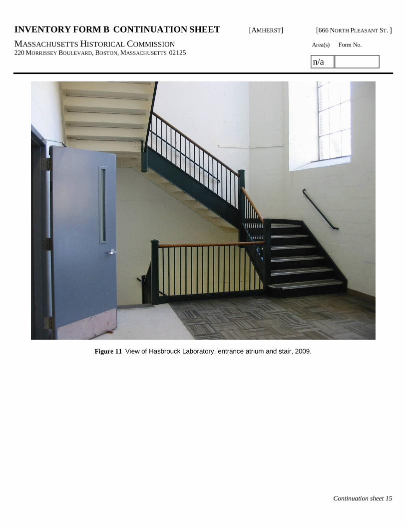
Figure 11 View of Hasbrouck Laboratory, entrance atrium and stair, 2009.
MASSACHUSETTS HISTORICAL COMMISSION Community Property AddressMASSACHUSETTS ARCHIVES BUILDING UMASS AMHERST Building #124 – 666 North Pleasant St.220 MORRISSEY BOULEVARDBOSTON, MASSACHUSETTS 02125
Area(s) Form No.
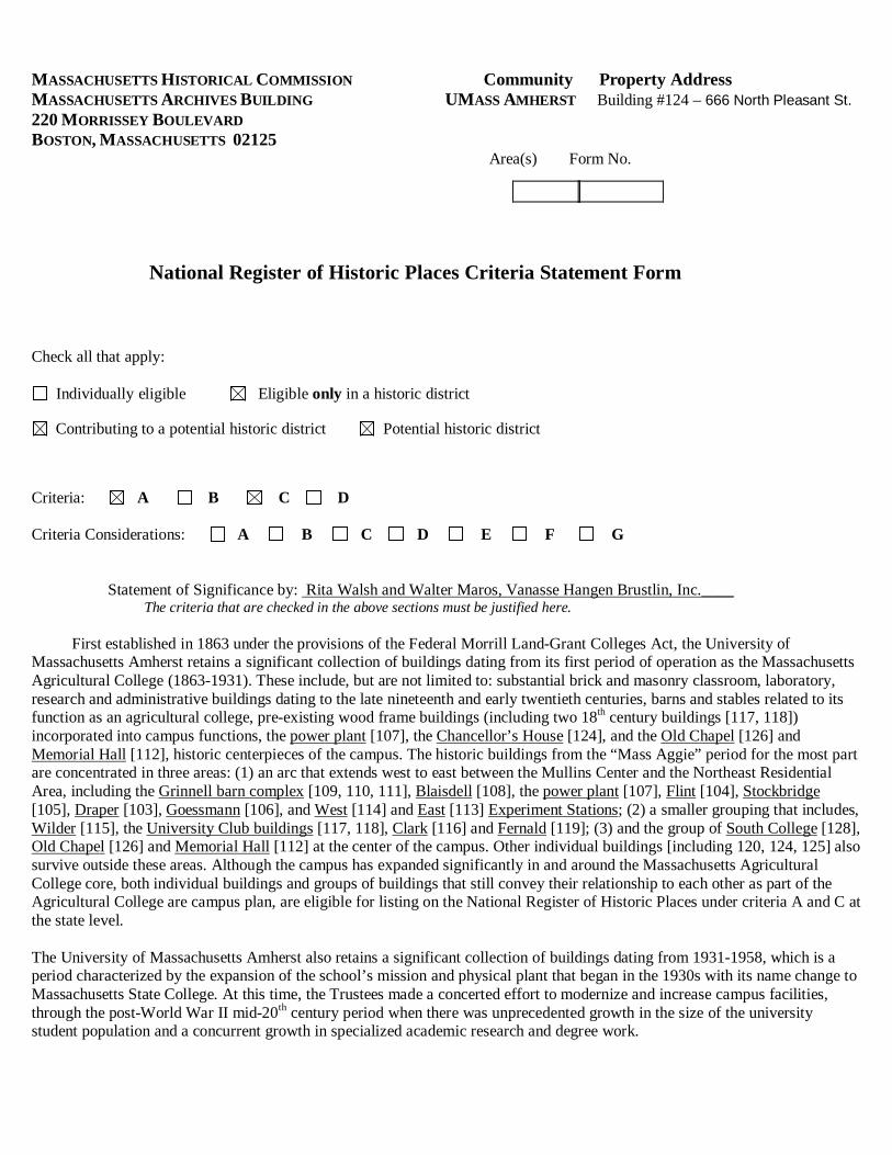
National Register of Historic Places Criteria Statement Form
Check all that apply:
Individually eligible Eligible only in a historic district
Contributing to a potential historic district Potential historic district
Criteria: A B C D
Criteria Considerations: A B C D E F G
Statement of Significance by: Rita Walsh and Walter Maros, Vanasse Hangen Brustlin, Inc.____The criteria that are checked in the above sections must be justified here.
First established in 1863 under the provisions of the Federal Morrill Land-Grant Colleges Act, the University ofMassachusetts Amherst retains a significant collection of buildings dating from its first period of operation as the MassachusettsAgricultural College (1863-1931). These include, but are not limited to: substantial brick and masonry classroom, laboratory,research and administrative buildings dating to the late nineteenth and early twentieth centuries, barns and stables related to itsfunction as an agricultural college, pre-existing wood frame buildings (including two 18th century buildings [117, 118])incorporated into campus functions, the power plant [107], the Chancellor’s House [124], and the Old Chapel [126] andMemorial Hall [112], historic centerpieces of the campus. The historic buildings from the “Mass Aggie” period for the most partare concentrated in three areas: (1) an arc that extends west to east between the Mullins Center and the Northeast ResidentialArea, including the Grinnell barn complex [109, 110, 111], Blaisdell [108], the power plant [107], Flint [104], Stockbridge[105], Draper [103], Goessmann [106], and West [114] and East [113] Experiment Stations; (2) a smaller grouping that includes,Wilder [115], the University Club buildings [117, 118], Clark [116] and Fernald [119]; (3) and the group of South College [128],Old Chapel [126] and Memorial Hall [112] at the center of the campus. Other individual buildings [including 120, 124, 125] alsosurvive outside these areas. Although the campus has expanded significantly in and around the Massachusetts AgriculturalCollege core, both individual buildings and groups of buildings that still convey their relationship to each other as part of theAgricultural College are campus plan, are eligible for listing on the National Register of Historic Places under criteria A and C atthe state level.
The University of Massachusetts Amherst also retains a significant collection of buildings dating from 1931-1958, which is aperiod characterized by the expansion of the school’s mission and physical plant that began in the 1930s with its name change toMassachusetts State College. At this time, the Trustees made a concerted effort to modernize and increase campus facilities,through the post-World War II mid-20th century period when there was unprecedented growth in the size of the universitystudent population and a concurrent growth in specialized academic research and degree work.

Significant buildings that were constructed to meet the University’s needs between 1931 and 1958, as well as significantbuildings predating 1931 which have no prior Form B on file with the Massachusetts Historical Commission, include (listed inorder of construction date): [UMass 58]; Hatch Laboratory, built 1891 [UMass 118]; Clark Hall Greenhouse, built 1907 [UMass84], French Hall Greenhouse, built 1908 [UMass 105]; French Hall, built 1909 [UMass 104]; Waiting Station Shelter, built 1911[UMass 63]; Apiary Laboratory, built 1911 [UMass 74]; Hicks Physical Education Building, built 1931 [UMass121]; HicksPhysical Education Cage, built 1932 [UMass 122]; Thatcher House, built 1935 [UMass 30]; Research Administration Building,built 1939 [UMass 579]; Lewis House, built 1940 [UMass 28]; Butterfield House, built 1940 [UMass 5]; Greenough House,built 1946 [UMass 24]; Chadbourne House, built 1947 [UMass 6]; Mills House (New Africa House), built 1948 [UMass 29];Skinner Hall, built 1948 [UMass 128]; Gunness Laboratory, built 1949 [UMass 91]; Brooks House, built 1949 [UMass 4];Hamlin House, built 1949 [UMass 25]; Knowlton House, built 1949 [UMass 26]; Marston Hall, built 1950 [UMass 92]; PaigeLaboratory, built 1947 [UMass 6]; Hasbrouck Laboratory, built 1950 [UMass 124]; Baker House, built 1952 [UMass 3];Crabtree House, built 1953 [UMass 12]; Leach House, built 1953 [UMass 27]; Worcester Dining Hall, built 1953 [UMass 85];Arnold House, built 1954 [UMass 2]; Durfee Range, built 1955 [UMass 96]; Van Meter House, built 1957 [UMass 32];Machmer Hall, built 1957 [UMass 111]; Student Union, built 1957 [UMass 131]; Wheeler House, built 1958 [UMass 33]; andJohnson House, built 1959 [UMass 36].
The recommended University of Massachusetts Amherst historic district meets Criterion A for its association with the ongoingmission of this state university to meet the educational requirements of a rapidly changing world. From the inception of theUniversity in 1863 as the Massachusetts Agricultural College, through the current day, the Trustees have sought to provideeducational programming and facilities that would enable students to advance the practice of agriculture and a steadilyincreasing host of other fields, meet the needs of a rapidly-industrializing world, and succeed in leading a post-industrialinformation and technology-based economy.
The historic district also meets Criterion C for its stock of buildings and landscape features whose forms and functions reflect theevolving and expanding mission of the University in the 95 years between its 1863 founding and 1959 (1959 being the 50 yearcut-off for National Register consideration). A number of architects, landscape architects and planners of local, regional and/ornational prominence were involved in the design of the individual buildings and the overall plan of the current University ofMassachusetts Amherst campus. The aggregate efforts of these design professionals produced a distinctive public universitycampus landscape, primarily of the mid-19th to mid-20th century, which is unique in Massachusetts.
Despite the loss of certain buildings and landscape features up to the present time in 2009 and incremental physical changes seenin new window, door and roofing replacements, as well as siding replacements in a small number of buildings, the district retainsintegrity of location, setting, design, feeling, association, workmanship, and materials.