Embed Size (px)
Citation preview

Foreword
Beneath the scenic skin of Ireland there lies another world. It’s a world familiar only to a few – to those geologists who have quietly probed its depths, revealed its rocky basement and charted the journey of its prodigiously ancient roots. This ‘land below ground’ has a history that extends way beyond human lives and legends to leave a geological legacy that – for its modest size – is the most varied in the world. But this diverse geological mosaicbelow our feet is more than simply the bedrock underlay to the familiar wild places, farm-lands and towns above. It is the economic wealth of peoples past and present and the stone furnishing of the streets and buildings we see every day. Geology may lie out of sight, but in terms of its critical importance to the modern world it is far from being out of mind.
Which is where the Tellus Project came in. This project, named after the Roman goddess of the Earth, was conceived to catalogue Ireland’s hidden inventory and assess not only its contemporary value and usefulness, but also its threats and unknowns. Imagining and imaging what lies below us is a tricky business and requires a clever combination of surveying from above – magnetic, electromagnetic and radiometric mapping from low-flying specialist aircraft – and walking the ground to detect surface clues in the rocks and in the tens of thousands of soil, sediment and water samples collected for laboratory analysis.
This combined land and air offensive has been unprecedented – nowhere else on earth has been examined in such detail. As a result of over ten years of forensic examination, subsurface Ireland is probably the most intensively studied piece of geological real estate on the planet. The results have had immediate benefits in terms of promoting economic investment, unearthing valuable new information on the region’s mineral resources and mapping the environmental characteristics of a much-loved landscape. The dangers pre-sented by the rocky underworld are also now more apparent; the research highlights hot spots of natural radiation or possibly toxic contaminants leaking from deep metal-rich rocks, and appraises levels of industrial pollution in the cities.
All in all, the Tellus work is expected to have a huge impact on the economic, environ-mental, agricultural and health sectors. But perhaps the biggest prize of a decade of explor-ing hidden Ireland is a more complete understanding of the natural history of this region. It tells an epic story of how Ireland’s geological past will sustain its future.
Professor Iain Stewart MBEDirector of the Sustainable Earth InstituteSchool of Geography, Earth and Environmental Sciences, University of Plymouth
ix
Unearthed_260mm.indd 9 26/7/16 15:53:35
DOI:10.3318/978-1-908996-88-6.prelims
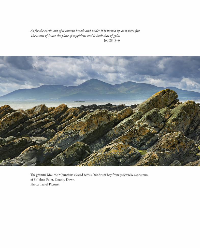
The granitic Mourne Mountains viewed across Dundrum Bay from greywacke sandstones of St John’s Point, County Down.Photo: Travel Pictures
As for the earth, out of it cometh bread: and under it is turned up as it were fire. The stones of it are the place of sapphires: and it hath dust of gold.
Job 28: 5–6
Unearthed_260mm.indd 10 26/7/16 15:53:39

Directors’ Foreword
The Tellus programme was conceived in the 1990s as a major geoscience project that would benefit the whole island of Ireland by providing modern geophysical and geochemical data with which to update geological mapping, stimulate investment in mineral exploration and generate an environmental baseline. It was envisaged that these data, collected on a regional scale to industry standards, would provide the coherent information needed to underpin new analyses of the geology and natural resources of Ireland. At the same time, it was recognised that these same data would define the baseline conditions against which exploration and development could be managed, in compliance with increasingly strin-gent environmental legislation.
Ireland is an important source of metallic ores, with over 50 years of modern mining, and is still the major European source of zinc. Other metals produced in recent history include copper, lead, silver, iron, and a range of industrial and energy minerals. Although gold is the major target of exploration companies in the north of Ireland today, there is also scope for new discoveries of base metals. Both mature and emerging economies need steady supplies of minerals and raw materials to underpin development. It makes sense, both economically and socially, to produce these minerals domestically under well-controlled environmental regulations than to import them from less robust regimes.
The first phase of the Tellus programme, in Northern Ireland, prompted a surge in exploration licensing and significant inward investment in exploration, which continues today. Funded initially by the Northern Ireland government (and co-funded retrospec-tively by the EU), the programme was seen as a project that would benefit all sections of the community and several sectors of the economy, in addition to that of natural resources. Benefits for agriculture, health, land-use planning and environmental monitoring were anticipated. The success of this first phase prompted further EU investment in a second phase, to extend the surveys over the border into the six northern counties of the Republic of Ireland, in a project managed jointly by the Geological Survey of Northern Ireland and the Geological Survey of Ireland, in partnership with Queen’s University Belfast and Dundalk Institute of Technology. This second phase, the Tellus Border Project, was com-pleted on time and within budget and generated a wave of research into all the areas envis-aged at project conception, and many more.
Today the Tellus initiative continues in the Republic of Ireland, where the intention is to complete the surveying of half of the country by 2017 and of all of the island of Ireland by 2023, and in Great Britain, where surveys of south-west England have recently been completed.
xi
Unearthed_260mm.indd 11 26/7/16 15:53:41

The Tellus and Tellus Border Projects have exemplified the value of government and EU investments in cross-border multi-partner, scientific initiatives where there is a common objective and complementary skills and experience. In addition to the evident success in the original aim of stimulating exploration, the projects have demonstrated more widely the scope for prompting research and international collaboration in a wide variety of fields. The purpose of this book is to illustrate some of these outcomes and impacts, on explora-tion, environmental management, land-use, agriculture and research, and to underline the value of an all-island approach to such endeavours.
In the introductory section, the various programmes of survey work, data analysis and presentation are described. In Part 2, the impacts of the new data are illustrated by chapters on gold and base metal exploration and the potential for further discoveries. The scope for geothermal resources is also discussed. Part 3 presents some of the applications of the data in agricultural and ecological management. Part 4 describes how the information has been used in various areas of environmental mapping and management; these include mapping of contaminated land and the legacy of the industrial past, human health, radio-activity and radon, carbon sequestration and geoforensic investigations.
The breadth of research presented in these chapters demonstrates the wealth of infor-mation that may be derived from these regional data, their impacts on and value to various economic and environmental sectors, and the immense benefits of cross-border research collaborations between government organisations, academia and industry.
Dr Marie Cowan Koen VerbruggenDirector, Geological Survey Director, Geological Surveyof Northern Ireland of Ireland
xii
Unearthed_260mm.indd 12 26/7/16 15:53:41

Acknowledgements
Sixty-nine authors, from industry, academia and government organisations, have contrib-uted to this book and I am most grateful to them all for their enthusiastic work in describ-ing such a wide variety of applications of the Tellus data.
I thank the many chapter reviewers who willingly and thoughtfully scrutinised the submissions. Their diligence has contributed substantially to the clarity and accuracy of many chapters and delivered significant new insights. Two anonymous reviewers assessed the volume for the Royal Irish Academy and their gracious encouragement and valuable suggestions have been much appreciated.
Many years of dedicated work underpin the research described in this book. This includes the demanding airborne surveys undertaken by skilled pilots, engineers and support staff; the long seasons of geochemical sampling, often performed in uncomfort-able field conditions; the meticulous analysis of samples in the laboratory; and the careful data processing consequent on all these functions. Some hundreds of individuals have contributed to the different aspects of data acquisition and processing and many more have brought innovation, imagination and skill to the interpretation of data and presentation of research. Project staff have been drawn from the Geological Survey of Ireland (GSI), the Geological Survey of Northern Ireland (GSNI), Queen’s University Belfast and Dundalk Institute of Technology. The British Geological Survey and its staff provided sustained guidance and support for many functions. Many specialist contractors acquired and deliv-ered much of the core survey data and two companies, Weber Shandwick and Morrow Communications, devised the vital communications and public relations programmes, which resulted in a wider understanding of the work throughout the north of Ireland. We are most grateful to all these individuals, companies and organisations for their essential and sustained contributions.
The project teams have been led notably by Marie Cowan, Ray Scanlon and Mairéad Glennon, with skill, dedication, tact and good judgement, and I am most grateful for their help over a long period.
Project management benefited immensely from the advice of expert steering groups, drawn from government departments with interests in the project. Chaired variously by senior civil servants including Robin McMinnis OBE, Noel Cornick, Michael Manley and Mike Thompson, the groups’ sagacity and strategic perspectives contributed both to the efficiency of field operations and to the breadth of impact of the results.
Since the inception of the Tellus Project in 2004, the Directors of GSNI and GSI have provided continual encouragement. I thank particularly the current Directors, Marie
xiii
Unearthed_260mm.indd 13 26/7/16 15:53:41
Cowan and Koen Verbruggen, who have actively encouraged and promoted the publica-tion of this book.
Once again, all involved are glad to acknowledge the foresight and vision of those who conceptualised and developed the Tellus idea in the late 1990s and early 2000s, notably John Arthurs and Garth Earls of GSNI, David Falvey and Mick Lee MBE of the British Geological Survey, Peadar McArdle and Pat O’Connor of GSI and Peter Taggart of the Department of Enterprise, Trade and Investment (NI). Kate Johnson of the US Geological Survey and Neal Lane, Scientific Advisor to President Clinton, encouraged and endorsed the concept. Theresa Kearney and the Northern Ireland Environment Agency provided active and informed support and advice since the project inception. The initial project design, drawn up by Dublin-based consultants CSA Group Ltd, led by Nick O’Neill, has proved durable and has been largely followed throughout.
The various stages of the Tellus Projects have been funded generously by the govern-ment of Northern Ireland (Department of Enterprise, Trade and Investment and Depart-ment of Environment); the government of the Republic of Ireland (Department of Com-munications, Energy and Natural Resources and Department of Environment); the British Geological Survey; and by two EU structural funds, the ‘Building Sustainable Develop-ment’ scheme of the Rural Development Programme, administered by the Department of Agriculture and Rural Development (NI), and the INTERREG IVA programme of the European Regional Development Fund, administered by the Special European Pro-grammes Body.
I am most grateful to the Royal Irish Academy for publishing this book and for their high standards of production. Ruth Hegarty, Jonathan Dykes and the team in the Publi-cations Office have been unfailingly supportive and full of good advice. Brendan O’Brien has undertaken the copyediting diligently, meticulously and with great tact.
Finally, I am especially indebted to Alex Donald, who has worked on the Tellus pro-gramme since the beginning. Alex has designed this book and carefully collated and assembled the diverse texts and figures, invariably with flair, dedication, patience and good humour.
Mike Young
xiv
Unearthed_260mm.indd 14 26/7/16 15:53:41
Table of Contents:
Prelim DOI:10.3318/978-1-908996-88-6.prelims
Chapter 1 The Tellus geosciences surveys of the north of Ireland: context, delivery and impacts DOI:10.3318/978-1-908996-88-6.ch1
Chapter 2 The Tellus airborne geophysical surveys and results DOI:10.3318/978-1-908996-88-6.ch2
Chapter 3 The Tellus geochemical surveys, results and applications DOI:10.3318/978-1-908996-88-6.ch3
Chapter 4 Stakeholder engagement for regional geoscientific surveying: the Tellus Border communications campaign DOI:10.3318/978-1-908996-88-6.ch4
Chapter 5 Mineral resources and Tellus: the essential balance DOI:10.3318/978-1-908996-88-6.ch5
Chapter 6 Gold exploration in the north of Ireland: new targets from the Tellus Projects DOI:10.3318/978-1-908996-88-6.ch6
Chapter 7 Using soil geochemistry to investigate gold and base metal distribution and dispersal in the glaciated north of Ireland DOI:10.3318/978-1-908996-88-6.ch7
Chapter 8 Critical metals for hightechnology applications: mineral exploration potential in the north of Ireland DOI:10.3318/978-1-908996-88-6.ch8
Chapter 9 A natural laboratory for critical metals investigations in the Mourne Mountains granites DOI:10.3318/978-1-908996-88-6.ch9
Chapter 10 Geothermal potential of granitic rocks of the Mourne Mountains DOI:10.3318/978-1-908996-88-6.ch10
Chapter 11 Shape and intrusion history of the Late Caledonian Newry Igneous Complex, Northern Ireland DOI:10.3318/978-1-908996-88-6.ch11
Chapter 12 Using Tellus data to enhance targeting of volcanogenic massive sulphide mineralisation in the Tyrone Igneous Complex DOI:10.3318/978-1-908996-88-6.ch12
Chapter 13 The geological significance of electrical conductivity anomalies of the Ordovician- Silurian Moffat Shale Group, Northern Ireland DOI:10.3318/978-1-908996-88-6.ch13
Chapter 14 Faults, intrusions and flood basalts: the Cenozoic structure of the north of Ireland DOI:10.3318/978-1-908996-88-6.ch14
Chapter 15 Information for agriculture from regional geochemical surveys: the example of soil pH in the Tellus and Tellus Border data DOI:10.3318/978-1-908996-88-6.ch15
Chapter 16 An ecohydrological investigation of wetlands in the border counties of Ireland: a framework for a holistic understanding of wetland systems DOI:10.3318/978-1-908996-88-6.ch16

Chapter 17 Assessing nutrient enrichment risk to groundwater-dependent ecosystems in the border counties of Ireland DOI:10.3318/978-1-908996-88-6.ch17
Chapter 18 Mapping the terrestrial gamma radiation dose DOI:10.3318/978-1-908996-88-6.ch18
Chapter 19 Soils and their radiometric characteristics DOI:10.3318/978-1-908996-88-6.ch19
Chapter 20Modelling in-house radon potential using Tellus data and geology to supplement inhouse radon measurementsDOI:10.3318/978-1-908996-88-6.ch20
Chapter 21Determining geochemical threshold values from the Tellus data sets: the examples of zinc and iodine|DOI:10.3318/978-1-908996-88-6.ch21
Chapter 22Identification of the geochemical signatures of diffuse pollution in the Tellus Border soil data set, using source apportionmentDOI:10.3318/978-1-908996-88-6.ch22
Chapter 23Stream sediment background concentrations in mineralised catchments in Northern Ireland: assessment of ‘pressures’ on water bodies in fulfilment of Water Framework Directive objectivesDOI:10.3318/978-1-908996-88-6.ch23
Chapter 24Mapping metallic contamination of soils in the Lower Foyle catchmentDOI:10.3318/978-1-908996-88-6.ch24
Chapter 25Refining the human health risk assessment process in Northern Ireland through the use of oral bioaccessibility dataDOI:10.3318/978-1-908996-88-6.ch25
Chapter 26Combining environmental and medical data sets to explore potential associations between environmental factors and health: policy implications for human health risk assessmentsDOI:10.3318/978-1-908996-88-6.ch26
Chapter 27Mapping a waste disposal site using Tellus airborne geophysical dataDOI:10.3318/978-1-908996-88-6.ch27
Chapter 28 The use of aero-magnetics to enhance a numerical groundwater model of the Lagan Valley aquifer, Northern IrelandDOI:10.3318/978-1-908996-88-6.ch28
Chapter 29Carbon sequestration in the soils of Northern Ireland: potential based on mineralogical controlsDOI:10.3318/978-1-908996-88-6.ch29
Chapter 30Spatial distribution of soil geochemistry in geoforensics DOI:10.3318/978-1-908996-88-6.ch30
End matterDOI:10.3318/978-1-908996-88-6.endmatter

Unearthed: impacts of the Tellus surveys of the north of IrelandFirst published in 2016 by theRoyal Irish Academy19 Dawson StreetDublin 2www.ria.ie
Copyright © 2016 Royal Irish Academy
ISBN: 978-1-908996-87-9
The articles in this book are open access and distributed under the terms of the Creative Commons Attribution 4.0 licence, which permits unrestricted use, distribution and repro-duction in any medium, provided the original authors and source are credited. To view a copy of this licence, visit https://creativecommons.org/licenses/by/4.0/
Except where noted:Geological mapping for Northern Ireland / Tellus data are provided by the Geological Survey of Northern Ireland. Geological mapping for Ireland / Tellus Border data are provided by the Geological Survey of Ireland. Topographic mapping for Northern Ireland is derived from Land and Propery Services Open Data and contains public sector information licensed under the Open Gov-ernment Licence v3.0. (http://www.nationalarchives.gov.uk/doc/open-government-licence/version/3/).Topographic mapping for Ireland is derived from Ordnance Survey of Ireland Open Data (https://creativecommons.org/licenses/by/4.0/legalcode).
While every effort has been made to contact and obtain permission from holders of copy-right, if any involuntary infringement of copyright has occurred, sincere apologies are offered, and the owner of such copyright is requested to contact the publisher.
British Library Cataloguing-in-Publication Data. A catalogue record is available from the British Library.
Design: Alex Donald, Geological Survey of Northern Ireland.Index: Brendan O’Brien.Printed in Poland by L&C Printing Group.

![Österreichiche Bibliographie · 22 Cornick, Mike, 1947-: [Latin Sketches] Three latin sketches : for alto saxophone and piano / Mike Cornick ; for Mark Walton. - Wien : Universal](https://img.dokumen.tips/doc/110x75/5ae90d447f8b9ac3618bf797/sterreichiche-bibliographie-cornick-mike-1947-latin-sketches-three-latin-sketches.jpg)