Embed Size (px)
Citation preview


Forest Soils of New Brunswick
Mark C. Colpitts 1 Sherif H. Fahmy 2
John E. MacDougall I Tom T. M. Ng 1
Bryce G. Mclnnis 1 Vincent F. Zelazny ’
CLBRR Contribution No. 95 - 38
1 New Brunswick Department of Natural Resources and Energy; Timber Management Branch
2 Agriculture and Agri - Food Canada, Centre for Land and Biological Resources Research (CLBRR), Research Branch.
This project is funded under the Canada/New Brunswick
Forestry Agreement 1995
New Brunswick Department of Natural Resources and Energy Timber Management Branch
Agriculture and Agri-Food Canada Research Branch
Natural Resources Canada Canadian Forest Service

Copies of this report are available from:
New Brunswick Land Resources Unit Centre for Land and Biological Resources Research Research Branch, Agriculture and Agri-Food Canada P.O. Box 20280, Fredericton, NB E3B 427
Timber Management Branch New Brunswick Department of Natural Resources and Energy P.O. Box 6000, Fredericton, NB E3B 5Hl
Digital coverages of the soil maps are available at the Timber Management Branch at a 1:50 000 mapping scale.
Cover Photographs:
Top: Oblique scene of mixed woods growing on undulating landscape. Note hardwood and softwood distributions. (H. Rees photograph)
Lower left: A 1986 landsat imagery of groundcover in New Brunswick, Canada. (courtesy: NB Remote Sensing GIMAC Sub Committee)
Lower right: Virgin soil profile of Holmesville soil association, Orthic Humo-Ferric Podzol. (S. Fahmy photograph)

TABLE OF CONTENTS:
:’ ,
;
(‘;
‘1
LIST OF FIGURES AND TABLES .................................
ACKNOWLEDGMENTS ......................................
SUMMARY ................................................
INTRODUCTION ............................................
ECOLOGICAL FOREST SITE CLASSIFICATION .......................
NEW BRUNSWICK: GEOMORPHOLOGY AND CLIMATE .................
REGOLITH AND PLANT NUTRIENT SUPPLY ........................
Soil Reaction and Nutrient Availability ..........................
Weatherability ...........................................
Fertility ...............................................
FOREST SOIL MAP COMPILATION ..............................
Legend Development ......................................
Mapping Units ...........................................
Methodology ............................................
Key to Forest Soil Units Legend ...............................
FOREST SOIL UNIT DESCRIPTIONS .............................
I. Forest Soil Units (Regolith) Derived From Calcareous Sedimentary Rocks ...........................................
Forest soil units derived from argillaceous limestones and limestones .....................................
Forest soil units derived from calcareous siltstones, calcareous sandstones, and calcareous slates ............. Forest soil units derived from calcareous grey mudstones, and feldspathic to lithic sandstones .................... Forest soil units derived from non- to slightly- calcareous red polymictic conglomerates, feldspathic to lithic sandstones, and mudstones ..................................
v
vi
1
3
5
7
11
11 12 13
15
15 15 17 18
20
20
20
20
21
21
. . . III

II. Forest Soil Units (Regolith) Derived From Non-Calcareous Sedimentary Rocks . . . . . . . . . . . . . . . . . . . . . . . . . . . . . . . . . .
Forest soil units derived from metaquartzites, slates, metasiltstones, metasandstones, metaconglomerates, and metawackes . . . . . . . . . . . . . . . . . . . . . . . . . . . . . . . . . . . . Forest soil units derived from non-calcareous red mudstones . . . . . . . . . . . . . . . . . . . . . . . . . . . . . . . . . . . . . Forest soil units derived from grey lithic and feldspathic sandstones . . . . . . . . . . . . . . . . . . . . . . . . . . . . . . . . . . . . .
Ill. Forest Soil Units (Regolith) Derived From Igneous Rocks . . . . . . . .
Forest soil units derived from mafic volcanic rocks, gabbros, and diorites . . . . . . . . . . . . . . . . . . . . . . . . . . . . . . . . . . . . Forest soil units derived from gneiss, granites, alkali granites, granodiorites, and quartz diorites . . . . . . . . . . . . . . . . . . . . . Forest soil units derived from felsic volcanic rocks . . . . . . . . .
IV. Forest Soil Units (Regolith) Derived From Rocks of Mixed Lithologies . . . . . . . . . . . . . . . . . . . . . . . . . . . . . . . . . . . . . . . .
Forest soil units derived from metasedimentary rocks mixed with lower percentages of igneous rocks . . . . . . . . . . . . . . . . Forest soil units derived from igneous rocks mixed with lower percentage of metasedimentary rocks . . . . . . . . . . . . . . . . . . Forest soil units derived from grey to red sandstones or mudstones mixed with lower percentages of igneous rocks . . . .
V. Forest Soil Units Derived From Undifferentiated Parent Material . . . .
LITERATURECITED . . . . . . . . . . . . . . . . . . . . . . . . . . . . . . . . . . . . . . . . .
APPENDIX I:
APPENDIX II:
APPENDIX Ill:
APPENDIX IV:
Geomorphologic and Climate Regions of New Brunswick . . . . . . . . . . . . . . . . . . . . . . . . . . . . . . . . . . .
Geology for Novices (Primary Lithology or Rock Type) . . . .
Correlation of New Brunswick Soil Series/ Associations with Forest Soil Units . . . . . . . . . . . . . . . . .
Data Sources Used in Compilation of Forest Soil Unit Maps . . . . . . . . . . . . . . . . . . . . . . . . . . . . . . . . . . .
22
22
23
23
24
24
24 25
25
25
26
26
27
28
30
34
38
40
iv

LIST OF FIGURES AND TABLES:
FIGURES
Figure 1.
Figure 2.
Figure 3.
Figure 4.
Figure 5.
Figure 6.
Figure 7.
Figure 8.
Figure 9.
TABLES
Table 1.
Table 2.
Table 3.
Table 4.
Table 5.
Geomorphologic regions of New Brunswick . . . . . . . . . . . . . . . . . 8
The distribution of the general rock types of New Brunswick . . . pouch
Climate regions and subregions of New Brunswick . . . . . . . . . . . .
The relative weatherability and fertility of the common rock types found in New Brunswick. . . . . . . . . . . . . . . . . . . . . . . . . . . . . . .
The classification of igneous rock, depicting texture, mineralogy, and colour . . . . . . . . . . . . . . . . . . . . . . . . . . . . . . . . . . . . . . . .
A classification of sandstones and mudstones based on clast composition . . . . . . . . . . . . . . . . . . . . . . . . . . . . . . . . . . . . . . .
A classification of sedimentary rocks based on fine particle content and degree of metamorphism . . . . . . . . . . . . . . . . . . . . .
The classification of chemical and elastic sedimentary rocks: A) by percent calcite content and B) by carbonate content and grain size . . . . . . . . . . . . . . . . . . . . . . . . . . . . . . . . . . . . . . . . . . . . .
I :50 000 National Topographic System (N.T.S.) map index of New Brunswick depicting map locations in Table 5 . . . . . . . . . . . .
Four levels of forest site classification . . . . . . . . . . . . . . . . . . . . .
Forest soil units map legend . . . . . . . . . . . . . . . . . . . . . . . . . . . .
Summary of compiled soil surveys and geological maps to interpret forest soil units . . . . . . . . . . . . . . . . . . . . . . . . . . . . . . .
Correlation of New Brunswick Soil Series / Associations with Forest Soil Units . . . . . . . . . . . . . . . . . . . . . . . . . . . . . . . . . . . .
Summary of New Brunswick I:50 000 National Topographic System (N.T.S.) Maps with their associated references used in compilation . . . . . . . . . . . . . . . . . . . . . . . . . . . . . . . . . . . . . . . .
10
13
35
36
36
36
40
6
16
17
38
41
V

ACKNOWLEDGMENTS
The authors would like to acknowledge the contributions of those that helped directly or indirectly in the preparation of this report. Art Ruitenberg of the New Brunswick Department of Natural Resources and Energy (DNRE), Mineral Resources Division, and Herman van Groenewoud of the Canadian Forest Service - Maritimes, are thanked for their pursuit of a vision of better, holistic forest management. Les Fyffe, Toon Pronk, and Allen Seaman of DNRE, Mineral Resources Division we thank for their cheerful professionalism in patiently helping us up the geological learning curve over the past ten years. Past and present employees of DNRE, Timber Management Branch, who contributed to the understanding summarized herein include Colin Bowling, Mike Hayter, Dave Bewick, Marianne Erdle, Roger Roy, and Malcolm Banfield. Darrell Fowler, Marcia Creaghan, Annette Reid, and Jim Feltmate of DNRE all contributed with Geographic Information System support. Laura Collins of DNRE and Sylvie LaForest of Agriculture and Agri-Food Canada are thanked for their skill and patience in typing and formatting the manuscript. Thanks are also extended to Herb Rees and Ken Webb of Agriculture and Agri-food Canada, Dr. Helmut Krause of the University of New Brunswick (UNB), Toon Pronk of DNRE, Dr. Ted Needham of UNB, and Dr. Taumey Mahendrappa of the Canadian Forest Service - Maritimes for their valuable comments and review of the manuscript.
vi

SUMMARY
Soils strongly influence the development of forested ecosystems and have a marked effect on vegetation response to forest management. In New Brunswick, soil- related growth potential of forests is predicted using an ecological site classification system developed by van Groenewoud and Ruitenberg, (1982). This system measures regional climate, geomorphology, regolith and site (soil) type to classify broad ecosystems. A major advance in the development of the classification system involved province-wide mapping of forest soil units using previous information of forest-soil relationships. Maps of the forest-soil units are now used as an integral part of forest management and assist in forecasting wood supply. They are also used in ecological land classification.
Climate, particularly temperature and precipitation during the growing season, directly affects the development and properties of forest soils and influences forest productivity. Based on the work of Dzikowski et al. (1984), New Brunswick has been divided into four climatic regions. Moving from the cold, north-central and northwestern regions to the warmer southern and southeastern regions, rates of forest growth generally increase. Within each zone, rainfall amounts influence the availability of water for plant growth during the growing season.
New Brunswick geomorphology consists of a series of highlands, flat-topped rolling uplands, and lowland plains composed of both sedimentary and igneous rocks. Based on the work of Bostock (1970) and Rampton et al. (1984), New Brunswick landscape has been subdivided into six geomorphologic regions, each with distinct landform and bedrock geology. Within a climatic region, geomorphology influences large-scale drainage patterns, local variations in climate (topoclimate), and patterns of vegetation.
Unconsolidated glacial and post-glacial deposits of soil and rock fragments, known as regolith, overlie the bedrock and to a large degree determine the nutrient potential and textural characteristics of forest soils. It was proposed by van Groenewoud and Ruitenberg (I 982) that the regolith be divided into different segments based on mineral composition or primary lithology of its principal rock types. Each rock type is then assigned a quality rating based on its relative weatherability and potential fertility and thus the potential to supply nutrients for plant uptake.
The complex and dynamic interaction between soil and vegetation is defined by the site type, which is the most detailed level of the classification system.
A growing demand for links between ecological site information and forest stands resulted in the initiation of the forest soils mapping project at Timber Management Branch in 1989. This involved the identification of 50 forest soil units based on lithology, texture, depth, and coarse fragment content of the parent material

and solum as part of New Brunswick’s regolith system. Province-wide mapping of these units was based on extensive compilation and interpretation of forest, geological, and soil resource surveys. The information in this report can assist forest managers in predicting forest growth and vegetation development and consequently, could affect decisions concerning wood supply, ecology, wildlife, and recreation.
A series of maps showing the spatial distribution and properties of forest soil units and their drainage is included.
2

INTRODUCTION
Most of the variation in the distribution of plant communities is linked to environmental conditions created by the interaction of heat and light from the sun, the movement of air masses, elevation, the chemical nature of the rocks, and the characteristics of soils derived from these rocks. An understanding of the fundamental relationships among these variables and how they have contributed to the current distribution of ecosystems and organisms, can lead to more accurate predictions of the response of these ecosystems to future environmental change or disturbance. Mapped soils provide a level of such information. Therefore, to facilitate predictions of how terrestrial ecosystems in New Brunswick function, the soils were mapped by estimating inherent fertility and moisture gradients of forest sites.
In the early 1980’s a forest-site classification study was initiated at the Timber Management Branch of the New Brunswick Department of Natural Resources and Energy, as a joint project between the Government of Canada and the Government of New Brunswick. The objective of the program was to develop a system capable of discriminating differences in productivity among forest sites, in support of long-term timber supply and harvest forecasting. This study expanded on the earlier works of Loucks (1962), and van Groenewoud and Ruitenberg (1982) on site classification.
The “Forest Classification of the Maritimes” by Loucks (1962) was an early milestone in the development of ecological understanding in New Brunswick. Loucks mapped and described “Ecoregions” and “Ecodistricts” of the Maritimes based on climatic and physical (rock and soil) factors, using vegetation patterns to refine the classification. The classification defined the “Zonal Site Type”, which was named after the overstory vegetation characteristic of sites that are primarily influenced by regional climate. Later, collaborative work of an ecologist and a geologist (van Groenewoud and Ruitenberg 1982) described a methodology for applying many of the concepts, first expounded by Hills (1959), to New Brunswick’s unique conditions. They determined productivity of forest sites using regional climate, geomorphology, geology, and soil in a hierarchical system that focused on the relatively stable, enduring features of land. They demonstrated the importance of soil parent material for ecological interpretation in New Brunswick, where high variability in the inherent fertility and buffering capacity of different bedrock type lead to important soil differences. In New Brunswick, soil parent material distribution is fairly well-correlated with bedrock lithology, due to limited distances of glacial transport, and a preponderance of thin (1-2 m thick), medium-textured glacial deposits. Within a climatically homogeneous region, local forest ecosystem structure and productivity are well demarcated using soil lithology, depth, texture, and moisture as the principal mapping criteria.

The maps in this report are based primarily on integrated interpretations of previously published soil survey and surficial geology maps. The soil survey maps, though multipurpose, have an agricultural bias. They provide information on the most important or limiting factors affecting agriculture: soil texture, available rooting depth, slope, stoniness, and soil drainage. Because soil fertility can be amended by various means, including application of fertilizer, lime, manure, or growth of “green manure” crops, inherent soil fertility is less critical in agriculture than in forestry. However, natural plant communities, such as forests, depend almost entirely on on-site fertility generated from nutrient elements released by weathering of soil parent material (i.e. the rocks in the soil), nutrients added by atmospheric deposition, and nutrients cycled from the breakdown of litter from current vegetation. Of these sources, inherent soil fertility depends most on the geological origin of soil materials or regolith. Therefore, the lithology of the soil parent material is emphasized in the definition of forest soil units.
The purpose of this report is to provide a province-wide inventory of forest soil resources based on background information on climate, geomorphology, and regolith (parent material). The information is directed toward forest ecologists and soil scientists, but it is also useful to foresters, agronomists, engineers of applied science, and interested public and private landowners.
4

ECOLOGICAL FOREST SITE CLASSIFICATION
Forest soil information plays an important role in forest planning by providing a means to determine forest growth, and hence to predict allowable harvest rates. Although the role of soil in determining growth potential of forests is recognized, it is clearly not the only factor to consider. In Canada, the total site or ecosystem approach to forest management was first introduced by Hills (1952) as a study of a complex system composed of many interrelated parts, including climate, physiography, soil, and vegetation. Since then, many systems in Canada have adopted multifactor approaches to ecological classification, recognizing a hierarchy of factors which operate with increased effect as one moves down the hierarchy.
In New Brunswick, a specific approach to Ecological Forest Site Classification was identified by van Groenewoud and Ruitenberg (1982). The classification system describes four levels, from broad-scale to highly localized (Table 1).
Climate is considered to be the first level of the system because of its broad control on vegetation character, species composition, and growth. The particular climate of any spot on the landscape can be interpreted as a function of three levels of climatic conditions acting simultaneously. Macroclimate is the broad-scale climate of a region, derived from the movement of air masses, degrees of latitude, and elevation. Topoclimate refers to the typical weather conditions of smaller areas, such as valleys and ridgetops, that result from factors such as aspect, steepness of slope, and slope position. Microclimate refers to the actual stand-level conditions in which a plant or tree grows.
Geomorphologic districts are areas with distinctive terrain characteristics that reflect the weatherability and fertility of major bedrock units on the landscape. These characteristics are determined from its topography, regional drainage patterns, local variations in topoclimate due to slope steepness and aspect, and the supply of nutrients to the surrounding biota.
Regolith is a general term for the entire surface layer of unconsolidated material which includes soil and rock fragments, either weathered in place (residual) or transported by glaciers, that covers solid rock (bedrock). van Groenewoud and Ruitenberg (1982) proposed that the regolith should be divided into different segments based on landform and texture of the surficial materials and their rock and mineral composition. It is these parameters that are important in respect to the release of plant nutrients in the soil.
The site type is the most detailed level of the system. It is an expression of the complex and dynamic interaction between soil and vegetation and is characterized by
5
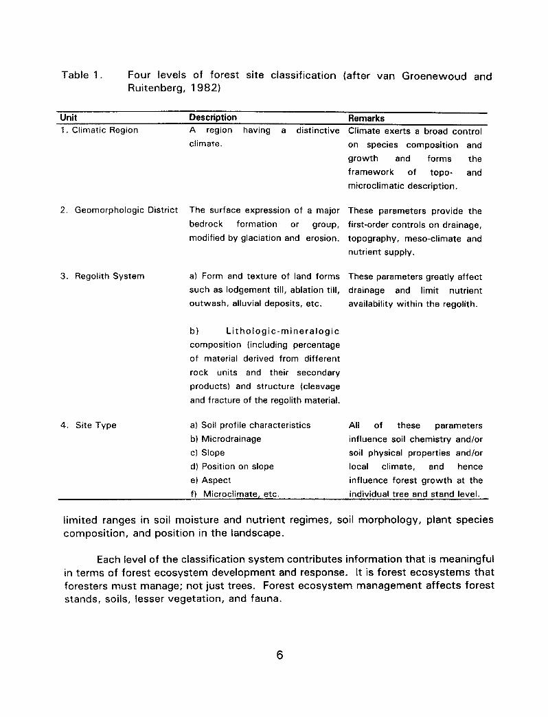
Table 1. Four levels of forest site classification (after van Groenewoud and Ruitenberg, 1982)
Unit Description Remarks 1. Climatic Region
2. Geomorphologic District
3. Regolith System
4. Site Type
A region having a distinctive
climate.
The surface expression of a major
bedrock formation or group, modified by glaciation and erosion.
a) Form and texture of land forms
such as lodgement till, ablation till,
outwash, alluvial deposits, etc.
b) Lithologic-mineralogic
composition (including percentage
of material derived from different
rock units and their secondary
products) and structure (cleavage
and fracture of the regolith material.
a) Soil profile characteristics All of these parameters
b) Microdrainage influence soil chemistry and/or
c) Slope soil physical properties and/or
d) Position on slope local climate, and hence
e) Aspect influence forest growth at the
Climate exerts a broad control
on species composition and
growth and forms the
framework of topo- and
microclimatic description.
These parameters provide the
first-order controls on drainage,
topography, meso-climate and
nutrient supply.
These parameters greatly affect
drainage and limit nutrient
availability within the regolith.
f) Microclimate, etc. individual tree and stand level.
limited ranges in soil moisture and nutrient regimes, soil morphology, plant species composition, and position in the landscape.
Each level of the classification system contributes information that is meaningful in terms of forest ecosystem development and response. It is forest ecosystems that foresters must manage; not just trees. Forest ecosystem management affects forest stands, soils, lesser vegetation, and fauna.
6

NEW BRUNSWICK: GEOMORPHOLOGY AND CLIMATE
New Brunswick is located at the northern limits of the Appalachian Mountains in Canada. A landscape of highlands and flat-topped, rolling uplands from the Bay of Fundy northward to Chaleur Bay forms a semi-circle around a triangular lowland extending to the Northumberland Strait and Gulf of St. Lawrence. The present landscape has evolved from the action of tectonic and erosional forces during the past 142 M years. During the Quaternary period (from 1.5 M years ago to the present) the landscape has been modified by the effects of climate change through glaciation and the submergence and emergence of lowlands due to fluctuating sea levels.
GeomorDholoay: The geomorphology of New Brunswick indicates a strong correlation between bedrock geology and landform. The composition of underlying formations of igneous and sedimentary rocks, and their relative abilities to resist surface weathering and the effects of glacial and fluvial erosion over time, have determined the scale and form of topographic features. A complex geology is reflected in the physical landscape of highlands, upland plateaus, lowlands, and plains that give New Brunswick its distinctive character. In addition, bedrock geology, landform, and topography have influenced broad-scale drainage patterns, climate, soil properties, and the distribution and pattern of forest ecosystems.
New Brunswick’s geomorphologic regions, originally defined by Bostock (1970), and modified by Rampton et al. (1984), include the Edmundston Highlands, Chaleur Uplands, Miramichi Highlands, St. Croix Highlands, Caledonia Highlands, and the New Brunswick Lowlands (Figure 1). The general bedrock lithology of New Brunswick is shown in Figure 2 (in the plastic pouch). It is the differential weathering of these rock types that determines surface expression, nutrient potential and textural characteristics of the soil. The gross morphology and bedrock geology of each geomorphologic (Physiographic) region are summarized in Appendix I.
Climate: Geomorphology (Physiography) and landform have a major impact in determining the differences between regional climates. Generally, regions at higher elevations experience cooler temperatures, shorter growing seasons, and higher precipitation than lowland areas. Elevated landscapes tend to force moving air masses upwards, causing water to condense and fall as precipitation in highland regions. This phenomenon is known as the orographic effect. The proximity of land mass to water also plays a major role in determining macroclimatic differences. In New Brunswick, the cold Atlantic waters of the Bay of Fundy provide a pronounced cooling effect along the southern coastal areas during the growing season, whereas the effect of the relatively warm waters of the Northumberland Strait is less dramatic. Coastal
influences decrease further inland due to the prevailing westerlies that generally blow off-shore.

Figure 1. Geomorphologic Regions of New Brunswick (Bostock 1970; modified by Rampton et a/. , 1984).
8

As a result of the complex interaction of these factors, wide fluctuations in seasonal and daily temperatures are common and a wide range of growing conditions occur in New Brunswick. Growing seasons are generally characterized by cool, wet springs and autumns, and warm summers with ample rainfall and infrequent droughty periods (Dzikowski et a/. 1984).
Measures of climate that describe the length and warmth of the growing season, and potential soil moisture levels are two defining characteristics of regional climate. An area of uniform regional climate is typically characterized by a specific range of growing degree-days above 5OC and some measure of annual or seasonal precipitation. New Brunswick can be divided into four climatic regions based on the number of annual growing degree-days (DD) above 5OC, where each region is subdivided on the basis of total precipitation from May to September (Figure 3). Climatic regions with the highest number of growing degree days and plentiful precipitation tend to be most favourable for tree growth. A provincial climate region map was produced by van Groenewoud (1983) as a test of new methodology using multivariant analysis of climate station data. However, maps produced by Dzikowski et a/. (1984), using these data and first principles of meteorology, were preferred over the former, for interpreting climatic patterns. New Brunswick’s four climate regions are described in Appendix I.

Legend:
Annual DD > 5” C May - Sept. rain (mm)
1. >I800 A 350-400
2. 1600-l 800 B 400-450
3. 1400-l 600 c 450-500
4. 1200-l 400 D 500-550
Climate Regions
Climate Subregions
Figure 3. Climate Regions and Subregions of New Brunswick (after Dzikowski et al. 1984).
10

REGOLITH AND PLANT NUTRIENT SUPPLY
Soil Reaction and Nutrient Availability: As soil constitutes the uppermost portion of the regolith, it is considered to be the major source of plant nutrients. Primary lithology or rock types (Appendix II) found in soil contribute to the fundamental chemical make-up of the mineral portion of soil.
The relative quantities of mineral elements in the soil have important effects on biological systems of a site. In this section we attempt to highlight the effects of the geological nature of soil parent material (regolith) in determining soil character and the type of life it will support. An important soil-forming process in humid regions like Atlantic Canada is eluviation or leaching, which is the downward movement of material in the soil profile from upper layers to lower layers. Leaching is the removal of materials in solution from the soil. It occurs when input to the soil of water from precipitation exceeds the loss of water from evapotranspiration. The result is a net downward movement of water and nutrients in the soil profile, with some nutrients being flushed out beyond the reach of plant roots. The movement of nutrients is influenced by soil moisture regime, which refers to the water supply over time, as affected by soil properties and landscape position. Well- and rapidly-drained soils are relatively deep, loose, and permeable, and vegetation roots penetrate deeply. Rapidly- drained soil has higher conductivity and lower retention of water than well-drained soil and inherent nutrients are lost at a faster rate. Moderately well- and imperfectly- drained soils, however, have lower conductivity and higher water retention, whereas poorly- and very-poorly drained soils barely conduct water and retain it for prolonged periods of time. In fact, the presence of water in the profile acts in two different ways; first mechanically, by allowing or preventing water percolation or movement in different directions; secondly, it has a direct physio-chemical effect by modifying the process of oxidation/reduction in soil, and hence soil inherent fertility and nutrient availability are affected.
Many biological and chemical processes by which soil sustains life require the presence of water in specific quantities. Too much or too little soil moisture can have a limiting effect on plant growth.
Some of the elements mobilized by leaching include important nutrients (basic elements) such as potassium (K), calcium (Ca), and magnesium (Mg). In addition to playing crucial roles in plant growth and structure, these elements are significant regulators of soil acidity. Acidity increases as the concentration of hydrogen (H) and aluminum (Al) ions in the soil solution increase relative to the concentration of calcium and magnesium ions. Rainwater contains hydrogen ions but almost no calcium or magnesium. Therefore, there is a general tendency for soils in the wet Maritime climate to become acidified over time. However, the process of acidification is slower on well-buffered soils (soils with abundant Ca, K, and Mg relative to Al and H). It
11

should be noted that soil acidification is an entirely natural process, but it is accelerated by the additional acidity contributed by air pollution (acid rain).
While a percentage of the soil’s basic cations are lost through the leaching process, weathering of rocks and minerals releases new potassium, calcium, and magnesium ions into the system.
Weatherability: Rates of weathering are influenced by the physical and chemical properties of rocks. Physical properties of rocks, such as the extent of cleavage or fracture, crystal size, and in the case of sedimentary rocks, the relative proportions of sand, silt, and clay, are important influences on weatherability rates. Figure 4 depicts the relative weatherability and fertility of the common rock types of New Brunswick.
It is helpful to think of rock not as solid material with an impermeable exterior and a “fresh”, unweathered interior, but as cracked and porous material with an active internal weathering surface much larger than its outer surface. A simple test of the weatherability of specific rock types in soil is to crack a sample with a rock hammer, and examine the extent of weathering as revealed by colour changes from the exterior surface to the centre. Weatherability of siliclastic sedimentary rocks increases along the continuum from quartzose, to feldspathic, to lithic types. Calcareous sedimentary rocks are more weatherable than non-calcareous sedimentary types because calcite reacts with carbon dioxide and rain water to produce soluble calcium carbonate. Granite and gneiss weather more slowly than sedimentary rocks because of their coarse, crystalline structures and relative lack of cracks and fissures, and an actively weathering surface area equal to, or only slightly greater than, its exterior surface area. Igneous rocks with abundant mafic minerals weather more rapidly than felsic igneous rocks. The weatherability of rocks in the metamorphic group is slow in the highly foliated types (gneiss and schist) but varies with their relative content of mafic and felsic minerals. The lesser-foliated slates and metaquartzites are more readily weathered than the highly-foliated types, but are more resistant to weathering than their unmetamorphosed counterparts.
At a microscopic level, soil particle size and type influence the weatherable surface area in the soil. Sedimentary rocks composed of significant amounts of clay- sized particles have especially high weathering surface area, because the clay particles can be conceived as loosely-connected wafers or sheets of silicate minerals which have an extremely high total surface area relative to their gross exterior dimensions. Fine-textured rocks containing clay-sized particles, such as metawackes and mudstones, weather readily because of the large surface area subjected to weathering processes. Sand grains are the other extreme of the continuum from large surface area to small surface area, with little weathering surface other than the outside surface.
12

POOR A B
SLOW ; Quartz-Pebble Conglomerates
Felsic Volcanic Rocks
1 / (Rhyolites)
j Felsic Pebble Conglomerates
2 Granites
Alkali Granites
3 j
4
Relative fertility
-..-c.-. .--__~_
Schllts Metaquartzites
Gneisses Granodiorttes Quartz Diites
Diodtes
Gabbros
RICH E
1
Polymlctii Metaconglomerates MafE Volcanic Rocks
Quarkose Sandstones (Basalts)
Metasandstones
Rolymictll conglomerates Slates
Metaslttstones
Lithic Sandstones Metawackes
Fektspathk Sandstones
5 j
Calcareous Sandstones Calcareous States
Cakareous Siltstones Calcareous Mudstones ’
Limestones
Argillaceous Limestones
FAST 1 .___~ j
Figure 4. The relative weatherability and fertility of the common rock types found in New Brunswick (after New Brunswick Dept. of Natural Resources and Energy Forest Site Classification Manual).
)&$jJ&y: Fertility is related to the ability of the chemical constituents of rock to buffer or neutralize the acidity in rainwater. Felsic-volcanic and granitic rock types are nutrient poor relative to their mafic counterparts of equivalent texture (basalts and gabbros, for example) because of their high content of quartz and low relative quantities of calcium and magnesium. Sedimentary rocks are composed of rock fragments and minerals from all the above-mentioned igneous rocks, and therefore
13

yield soils of higher fertility than their quartzose counterpart, and lithic sedimentary rocks are dependent on the lithology of the constituent clasts. Calcareous sedimentary rocks are relatively rich in plant nutrients, while at the other extreme, quartz-rich sedimentary rocks are generally poor nutrient sources. Feldspathic sedimentary rocks are moderately rich nutrient sources, because they contain abundant feldspars and micas relative to quartz-rich rocks.
Soils that have a circumneutral or only slightly acid pH tend to have high biological activity relative to acid soils. Elevated biological activity enhances site productivity through secondary beneficial effects, such as nitrogen fixation. High activity by soil organisms also leads to rapid organic matter breakdown and nutrient cycling. Valuable nutrient components of the detritus or wastes from plants and animals become available to support plant growth processes. In acidic conditions, the breakdown of organic matter is slow, and needles, leaves, twigs, and other detritus tend to accumulate as a thick mat on the soil surface. An extreme expression of this is the domed peat bog, where the only source of moisture and nutrients for the biota (mostly sphagnum mosses) is precipitation.
Levels of acidity also influence plant vigour. Plant species are either calciphilic or acidophilic, which means that they do best under neutral or acidic soil conditions, respectively. In this indirect way, rock types found in the soil influence the species of plants in a given locale. Acidic, infertile sites favour plant species that can internally recycle important nutrient elements like nitrogen, potassium, magnesium, and phosphorus prior to releasing litter back to the soil. Such plants tend to have long- lived foliage and to be sclerophyllous (ie., having thick, fibrous leaves), and their litter contributes little value for nutrient cycling. Black spruce, jack pine, and the ericaceous shrubs Kalmia anaustifolia and Rhododendron canadense are examples. However, such plants sacrifice some growth efficiency for their nutrient-conserving strategy. On less acid sites, the frequency of sclerophyllous plants is lower, and there is greater frequency of deciduous trees and herbaceous species. Many significant correlations have been established between species and plant community frequency and soil chemical characteristics (e.g., Baldwin and Sims (1989) and Zelazny et al. (1989)). Correlations between vegetation and the environment are important components of the information base necessary to design strategies for biological conservation.
While nutrient potential is broadly regulated by lithology of the rocks that make up the soil, local influences, especially fire history, cutting patterns and methods, and past land use (agriculture) can have an overriding effect on nutrient supply.
14

FOREST SOIL MAP COMPILATION
Leaend Development: The basic unit of mapping in this report is the Forest Soil tJ&, which is defined as a “naturally occurring segment of the regolith with distinct litholog y characterized by the overlying parent material and solum”. The solum (A and B horizons) and parent material (C horizon) of each unit are described in terms of their primary lithology, mode of deposition, textural class, depth to contrasting layer or thickness, and coarse fragment content.
The central concept of forest soil units is based on mapping units known as “Soil Associations” (Fahmy et al. 1986). Soil associations are natural groupings of soils with similarities in climatic and geomorphologic factors and soil parent material. To date, more than 140 soil associations have been identified in New Brunswick. Within associations, drainage variations (i.e., rapid to very poorly-drained), and associated profile characteristics are recognized at the series level, resulting in about 250 unique soil series. The basic difference between a soil association and a forest soil unit is that a soil association possesses a regional climatic context that is built into its definition and distribution, whereas forest soil units do not connote a climatic reaime, but are defined whollv on the reaolith’s orooerties and aross moroholoav of its orofile. By defining forest soil units in broader terms than soil associations, similar soil associations could be grouped together, reducing the total number of forest soil units to 50. Forest soil units with equivalent soil associations and series are listed in Appendix III, Table 4.
There are a total of 48 mineral forest soils units, one organic soil, and one land type (MD = mining debris). Mineral soil map units are differentiated on parameters that include the primary lithology of the parent material(s), texture class of the solum (A and B horizons) and the parent material (C horizon), and depth to a contrasting layer (contrasting due to texture, consistency, degree of compaction or cementation and/or the presence of bedrock). They are described fully in the map legend (Table 2).
Maooina Units: The mapping unit consists of the abbreviated forest soil unit names (2 letters) followed by a numerical drainage class modifier (i.e. CA3). Both internal drainage (resulting from texture, consistence, porosity, presence of compaction, stoniness and/or rockiness) and external drainage (resulting from slope, slope position, and the catchment area of the polygon) are integrated into the numerical drainage class modifier.
15

Table 2. Forest Soil Unit map legend
Erb Settlement
Red polymictic conglomerates, feldspathic to lithic sandstones and/or
Calcwm carbonate present in the cwnenting
Metaquartzrtes, slates, metasiltstones, metasandstones, metaconglomerates and/or metawackes
Red mudstones (weathered)
Mmor grey-red Itthtc-feldspathic sandstones. ~~artm~e sandstonss and/or polymucrlc
Grey lithrc-feldspathic sandstones
Glaciofluvial
Compact till
, n
M-C 1 c 1 4 1 L-H M iFI I-‘, 1 I
C-M 1 F 1 2-3 L-M ii
ompact till M IM-C I 4 1 L-M II
lmarmel 3ot till I c I M-F I 3 I L II compk-.
Compact till C-M 1 M-F 1 2 1 M
Non-compact till c ” ’ - ’ ” I .a,, n-:> -I
L.-M L
“eSlO”al , M-C C
Gleciofluvial, marine c C nr cdi71n
4 M-n
1-3/R M-H
3-4/R L-H II I -. I-..-.. I I I
17 1 43445 M ,t, L
!i
KI 63 546 Mafic volcanic rocks, gabbros and/or Compact till
M IM-Cl 2 . diorites MV 106 595 Residual or non-
comoact till M IF-M 1 1-3/R 1 M-H 11
II Tuadook 1 TU 142 527 Compact till I 1 JU 245 307 . Gneiss, granites, alkali granites,
granodiorites and/or quartz diorites Non-compac’ &“I ’
48 283 Residual
200 003 Compact till 100 974 Non-comoact till 1 JR
Felsic volcanic or mixed igneous rocks and/or felsic pebble conglomerates
Jacquet Rwer II. llLomond
M-C IM-C( 2 i L II
M IM-Cl 1-3/R 1 M-H 11
Catamaran
Irving
Plnder
RogerswIle
CT 117 735 igneous rocks mixed with Compact till M M-C 2 L metasedimentary rocks
IA 121 426 Non-compact till M M-C 4 M-H
38 828 ,Sedlmentary clasrs 20 50%1
PI Residual M-C M-C 1-3 M-H
Grey-red sandstones or mudstones RG 39 529 mixed wth Igneous rocks Compact till C-M M-F 2 L
Acadia AC 15 299 Undrfferentiated Tidal M-F M-F 1-2 L
Orgamc Soil OS 235 644 Paludification
M!rxnq Debris MD 5 901 Anthropoqenic
16

-
Methodoloay: Prior to delineating forest soil map unit polygons, all existing relevant data sources were compiled (Table 3). These data differed with respect to scale, content, and quality. All existing geological (bedrock and surficial geology) and soil survey maps were reproduced as I:50 000 scale, paper and plastic overlays. The most detailed data were obtained from about 5000 field plots, previously classified to the level of the forest soil unit. These were indicated as points, with an associated forest soil unit classification code, on 1:50 000 scale plastic overlays. Because vegetation types are known to be correlated with specific soil conditions, New Brunswick forest inventory data were also used. The vegetation data assisted in the interpretation of organic deposits, poor drainage areas, and poor and rich site conditions.
Table 3. Summary of compiled soil surveys and geologic maps used to interpret Forest Soil Units
MAP OR OVERLAY TYPE
JEW BRUNSWICK SOIL SURVEY lEPORTS (New Brunswick and Federal Iepartments of Agriculture; various authors 1938-l 993)
IEGOLITH SYSTEM MAP SERIES N.B. Dept. of Natural resources & inergy; Mineral Resources Branch; rarious authors)
;EOMORPHOLOGIC DISTRICT MAPS N.B. Dept of Natural Resources & inergy; Timber Management Branch; Jnpublished, 7 994)
5URFlClAL GEOLOGY, NEW 3RUNSWICK (Rampton V.N. 1984; jeological Survey of Canada)
;EOLOGIC (NR) MAP SERIES N.B. Dept of Natural Resources & Energy; Mineral Resources Branch; various authors)
AGGREGATE RESOURCE MAP SERIES [N.B. Dept of Natural Resources & Energy; Mineral Resources Branch; various authors)
NATIONAL TOPOGRAPHIC SYSTEM MAP SERIES (Geological Survey of Canada)
T SCALE 81 COVERAGE 1 L I
various scales and coverages (see Appendix III)
1:50 000 various coverages (See Appendix III)
1:50 000 Province-wide
I:500 000 Province-wide
I:250 000 various coverages
1:50 000 Province-wide
I:50 000 Province-wide
INTERPRETIVE USE II
Ielineation of various soil types rnd their attributes. Interpretation or Forest Soil Units varied with eve1 of detail and coverage of soil iurvev reoorts.
Delineation of till types, and nineral composition of regolith derived from intensive ground rampling.
Ielineation of various bedrock mits, and the rock types within ?ach unit. Used to infer mineral :omposition of tills.
Delineation of lodgement and ablation tills, morainal and colluvial sediments, outwash and marine ieposits, and glacial ice flow latterns.
delineation of bedrock geology Jsed to infer mineral composition of local tills.
Delineation of glaciofluvial (sand & gravel) ablation, ice contact and marine deposits.
Interpretation of landscape position, elevation, slope, used to infer depositional modes and drainage. Ii

Using the compiled information and professional knowledge of forest soil relationships as an “expert system,” forest soil unit polygons were delineated on the 1 : 50 000 scale plastic sheets. The degree of interpretation required during each mapping session, and our confidence in the resulting definition of the forest soil unit, were a function of the quality of the resource information available for each area. Appendix IV, Table 5 alphabetically lists the various sources used in the compilations.
Although boundaries between soil polygons are shown as single lines, in reality they represent approximate gradients or transition zones where one forest soil unit grades into another. As a result of the scale of mapping and the often complex and intricate pattern of soils across landscapes, inclusions of unspecified soils or non-soil bodies may occupy up to 30% of each forest soil unit polygon.
Kev to Forest Soil Units Leaend
Primary Litholoay: In Table 2 forest soil units are grouped according to their primary lithology or the mineralogical composition of their parent material. Primary lithology is the percentage of the individual rock types of which the parent material is composed. Rock types and geological terms in the legend are based on nomenclature used by Davies, J.L. 1977 (NR3) and McLeod et al. 1994 (NR5, NR6).
The proportions of rock types associated with each forest soil unit are related to distinct geomorphological districts or GDs. A GD indicates the surface expression and geographical approximation of major bedrock formation(s) or groups (Williams et a/. 1985), of known composition, that have been modified through glaciation and fluvial erosion. The relative weatherability and fertility of rock types within each GD and parent material greatly affect the physical and chemical properties of the soil, and influence the potential amount and type of nutrients available for tree growth.
In the field, primary lithology is determined by identifying the relative proportion of different rock types in the coarse fragment content of the soil.
Mode of Deposition: Surficial deposits are the result of past and present weathering within a geological environment (Rampton et al. 1984). The modes of deposition refer to the origin of these surficial materials or regolith. Those used in the legend of the forest soil unit map are;
1. Alluvial (deposited by post-glacial streams and rivers) 2. Anthropogenic (man-made deposits) 3. Compact till (deposited at the bottom of an advancing glacier) 4. Eolian (wind deposits) 5. Glaciofluvial (deposited by glacial streams and rivers)
18

6. Glaciomarine (combined glacial and marine deposits) 7. Lacustrine (lake-bottom deposits) 8. Non-compact till (deposits from melting glaciers) 9. Marine (sea-bottom deposits) 10. Paludification (peat formation) 11. Residual (pre-glacial; in situ deposits) 12. Tidal (deposits left by tidal waters).
Depth to Contrastina Laver: The contrasting layer refers to a distinct soil profile horizon having a firm or very firm consistency. This layer or horizon inhibits root penetration. A compact parent material and rock are common examples of such layers. The depth-to-contrasting layer classes used in the forest soil unit map legend are:
1. 5 30 cm
2. 31-65 cm 3. 66-l 00 cm 4. > IOOcm R. rock.
Texture Class: The relative proportion of sand, silt, and clay particles (< 2 mm diameters) by weight, in a soil sample comprises the texture. A textural class is assigned to the solum and to the parent material. The textural classes used in the forest soil unit map legend are:
F - Fine sandy clay loam, clay loam, and clay M - Medium silt loam and loam C - Coarse sandy loam, loamy sand, sand.
Coarse Fragment Content: All rock fragments in the soil > 2 mm in diameter are known as coarse fragments. From smallest to largest they include gravels, cobbles, stones, and boulders. The classes, percentage by volume, used in the forest soil unit map legend are:
L - Low I 20%
M - Medium 21-50 % H - High 51-100%.
19

FOREST SOIL UNIT DESCRIPTIONS
The spatial distribution, composition, structure, and texture of regolith determine its permeability, surface area available for leaching, and ability to produce plant nutrients. The following key to forest soil units describes the major regolith units, their associated rock types, and the forest soil units that have formed in conjunction with them.
I. Forest Soil Units (Regolith) Derived From Calcareous Sedimentary Rocks
Forest Soil Units derived from aruillaceous limestones and limestones
The Caribou (CA), Sieaas (SE), and Undine Units (UN) are found mainly in the Chaleur Uplands region. Tolerant hardwood stands and cultivated lands are correlated with increasing calcareousness of the regolith. As a result of high concentrations of calcium carbonate in the parent rocks (> 50%), these soils are well buffered against acidity and weather rapidly. Flat, friable, weathered siltstone fragments easily crushed between thumb and forefinger are common in these soils, particularly where the bedrock approaches the surface. Their relatively high pH leads to increased biological activity and high fertility.
The Caribou Unit is on well- to moderately well-drained, non-compact glacial till. Caribou soils are fine-textured, silt loam to clay loam, contain few coarse fragments other than gravels, and are extensively cultivated. The Siegas && is on flatter terrain which has drainage impeded by shallow, firm clay loam parent material. The Undine Unit is a shallow soil over bedrock. It is usually well drained, and often occupies hillcrests. It is similar in texture to the Caribou Unit -*
Forest Soil Units derived from calcareous siltstones, calcareous sandstones, and calcareous slates
The Kedgwick (KE), Carleton (CR), Thibault (TH) and Muniac Units (MU) are in the Chaleur Uplands in association with the Caribou Unit, and in the Eastern Miramichi and Central St. Croix Highland Regions. These units are usually found on gently to strongly rolling terrain. The regolith is composed predominantly of calcareous sedimentary rock, often containing 15 to 50% calcium carbonate in the rock matrix. Weathering rates are relatively high, and inherent fertility of these units approaches that of units derived from limestone.
The Carleton and Thibault Units were deposited as compact and loose tills, respectively. The compact parent material of the Carleton Unit is finer in
20

texture (silt loam to clay loam) and less stony than that of the Thibault Unit (loam to sandy loam). The Thibault Unit is common on crests and upper slopes. The Kedawick Unit is restricted to portions of the northern Chaleur Uplands on regolith primarily developed from fine calcareous siltstone. The parent material is fine-textured (clay loams to clay), compact between 35 and 65 cm: coarse fragments are few. The Muniac Unit is a coarse-textured (sandy loam) glaciofluvial deposit containing a high proportion of gravels. Free carbonates can often be detected at depths of 1 m or more within the profile.
Forest Soil Units derived from calcareous grey mudstones, and feldspathic to lithic sands tones
The Erb Settlement (EB) and Saltsprina Units (SS) are in the Anagance Ridges geomorphologic region. The parent material has developed mainly from grey, calcareous, non-metamorphosed mudstones and sandstones. These units occur in close association with the soil units of the Salisburv Unit (discussed below) but have a grey parent material and a higher inherent fertility.
The Saltsorina Units developed on compact, lodgement till derived mainly from grey, calcareous mudstones. They are fine-textured soils (clay loam to clay) and contain few coarse fragments. The Erb Settlement Unit occurs as morainal veneer over sandstone or mudstone bedrock. The soil material is non- compact, medium- to fine-textured with moderate coarse fragments. In general, the Erb Settlement Unit occupies crest and upper slopes positions, while the Saltsprina Unit occupies lower slopes.
Forest Soil Units derived from non- to s/i’ht&-calcareous red po&mictic conulomerates. feids.pa thic to lithic sandstones. and muds tones
The Parleeville-Tobiaue (PT), Salisbury (SA), Parry (PR), Cornhill (CH), Tracadie (TD), and Kennebecasis Units (KN) are mainly within four distinct geomorphologic subregions; the Curventon-Bathurst Valley, the Tobique Basin, the Anagance Ridges, and the Tormentine Peninsula. The Tracadie Unit also occurs significantly in the Central Lowlands and Acadian Peninsula. The strongly rolling to flat topography is the result of different modes of deposition and variability in bedrock weathering rates. The parent rocks, although similar in appearance to the mudstones of the Stonv Brook group, are richer in calcium and feldspars, giving them higher inherent fertility and increased potential for plant nutrition. Large tracts of cultivated land associated with these units are found in the Sussex area and the Tobique River Valley.
The Salisburv and Parry Units. have developed on well- to imperfectly- drained lodgement tills and are separated on the basis of texture and origin of
21

the parent materials. The Salisburv Unit is derived mainly from red mudstone and has a fine-textured parent material (loam to sandy-clay loam). The Parry !& has a coarse-textured parent material (loam to sandy loam) and is primarily derived from red conglomerates and sandstones, with larger amounts of gravels and stones. The Parleeville-Tobiaue Unit shares many characteristics with the Parry Unit but has developed on a loose (non-compact), gravelly ablation till or has weathered in situ. The Cornhill Unit is similar to the -1, but is found mainly on the tops of ridges where bedrock is close to the surface. The coarse-textured (loamy sand to sand) Kennebecasis Unit was formed from glaciofluvial deposits, usually along river or stream valleys. The Tracadie Unit was developed from glaciomarine, marine and/or lacustrine deposits. These soils are fine-textured and generally contain no coarse fragments.
II. Forest Soil Units (Regolith) Derived From Non-Calcareous Sedimentary Rocks
Forest Soil Units derived from metaauartzites. slates. metasiltstones, me tasands tones. me taconalomera tes and me ta wackes
The McGee (MG), Holmesville(HM), Glassville (GE), Victoria (VI), and Grand Falls Units (GF) cover extensive areas in the Edmundston Highlands and Chaleur Uplands and are found to a lesser extent in the Miramichi and central St. Croix Highlands. The regolith is composed of fine-textured sedimentary rocks that have been altered and hardened by low intensity heat and pressure (metamorphism). The metasedimentary rocks generally weather more slowly and are more acidic than the calcareous sedimentary rocks and limestones.
The McGee, Holmesville, and Glassville Units are found in association with the medium- to coarse-textured metasandstones, metaconglomerates, and metaquartzites. Respectively, these units occur as non-compact, compact, and shallow tills, over bedrock, and usually have medium- to coarse-textured parent material (loam or sandy loam). The stony Glassville Unit is mainly on hillcrests and upper slopes, whereas the McGee Unit is at lower elevations on water- reworked midslopes. The Holmesville Unit is found mainly on bedrock-controlled topography, on all slope positions and is the most extensively cultivated unit of this group. The Victoria Unit is composed of non-compact water worked colluvial-till material that has developed from the fine-textured rocks of this group (metasiltstones, metawackes, and slates) and is mainly in middle to lower slope positions. The Grand Falls Unit formed from glaciofluvial gravel and is usually deposited as river terraces or outwash plains. Much of the gravel and sand-sized fraction of soils in this group is non-quartzose, being composed of minute siltstone and slate fragments.
22

Forest Soil Units derived from non-calcareous red mudstones
The Stony Brook (Se), Harcourt (HT), Tracy (TR), Barrieau-Buctoucha (BB), and Becaouimec Units (BE) are mainly in the New Brunswick Lowlands Region. These tills are typically poorly drained, acidic, and have a red, fine- textured parent material. The parent rocks are not metamorphosed and lack calcium, and the inherent fertility is moderate. Because of the relatively fast weathering rates, the parent rocks (red mudstones) are generally not found in the profile and the topography is gently rolling to flat.
The Stony Brook and Harcourt Units are compact lodgement tills characterized by their dark reddish (5YR), firm to very firm, slowly permeable, loam parent material. The Harcourt Unit is differentiated by a cap of yellowish- brown (1 OYR), friable sandy-loam till. The Tracy Unit is also a lodgement till, but unlike Stonv Brook and Harcourt soils, the parent material is coarser (loam- sandy loam) and internal drainage is better. The Barrieau-Buctouche Unit is restricted mainly to coastal regions and contains a surface mantle (25 - 100 cm) of marine and glaciofluvial loamy sand, overlying a clay-loam to sandy clay-loam parent material. The Becaauimec Unit is the only member of this group that lacks a compact parent material. It is found in the central western region of New Brunswick.
Forest Soil Units derived from urey lithic and fe/dsnathic sandstones
The Reece (RE), Sunbury (SN), Fair Isle (FA), and Riverbank Units (RI) are mainly in the western and northern New Brunswick Lowlands and to a lesser extent in the Caledonia Highlands. The parent rocks are non-metamorphosed grey sandstones, which lack calcium and contain high proportions of lithic and quartz fragments. These units occur in close association with the units of the Harcourt group, but have coarse-textured, grey parent material, and may contain higher proportions of stone and gravel.
The Reece Unit is the most common of the group. This unit was formed in a compact till on undulating to gently rolling terrain and consists of a medium- textured solum (sandy loam to loam) over a medium- to fine-textured, yellowish- brown parent material. On average, these units are moderately well-drained and contain low proportions of coarse fragments. The Sunbury and Fair Isle Units. generally contain higher proportions of coarse fragments, and are mapped as coarse-textured, non-compact tills. The parent material is usually yellowish- brown, friable, rapidly-permeable sandy loam to loamy sand. Fair Isle is distinguished from the Sunburv by a shallow lithic layer less than 1 m from the soil surface. The Riverbank Unit consists of coarse-textured marine and
23

glaciofluvial deposits containing few coarse fragments. The parent material is usually yellow-brown, acidic, loose, and rapidly-permeable loamy sand or sand. Bedrock may occur within 1 m of the soil surface.
Ill. Forest Soil Units (Regolith) Derived From Igneous Rocks
Forest Soil Units derived from mafic volcanic rocks, gabbros. and diorites
The Mafic Volcanic (MV), Tetagouche (TT), and Kingston Units (KI) are associated with highlands. These units were mapped throughout most of New Brunswick except in the New Brunswick Lowlands and the Edmundston Highlands regions. The parent rocks contain high percentages of plagioclase (sodium and calcium feldspars), magnesium, and iron. The presence of these dark-coloured minerals and the relative lack of quartz and potassium produce tills of relatively high inherent fertility. The weatherability of the parent rocks is intermediate between that of sedimentary and felsic igneous rocks.
The Mafic Volcanic and Tetaaouche Units are medium- to fine-textured tills, developed from mafic rocks of fine crystalline structure. The Mafic Volcanic Unit is found in upper slopes and hillcrests where bedrock outcrops are common and stoniness increases. The Tetaaouche Unit is a compact lodgement till occurring in mid- and lower-slope positions. The Kinaston Unit developed from parent rocks of coarser crystalline structures (gabbros and diorites). This unit developed on a compact lodgement till with a medium to coarse parent material texture and moderate coarse fragment content.
Forest Soil Units derived from cmeiss, uranites, alkali uranites, aranodiorites and auartz diorites
The Tuadook (TU), Junioer (JU), and Bia Bald Mountain Units (BD) cover extensive areas in the Miramichi Highlands and eastern St. Croix Highlands, and are found to a lesser extent in the Caledonia Highlands. The parent rocks formed from slow-cooling molten lava high in quartz and feldspars. Their composition and coarse crystalline structure result in slow weathering, a correspondingly rugged topography, and a slow release of plant nutrients.
The Junioer and the Tuadook Units are found in rolling to hilly topography. The Junioer Unit is loose, coarse-textured, friable, brown to yellowish-brown, and contains between 0 and 50% stones and boulders. The Tuadook Unit has developed on lodgement till, and is usually compact to a
24

depth between 30 and 65 cm. Parent material texture ranges from loam to silt loam, and contains moderate amounts of coarse fragments. The Big Bald Mountain Unit forms a shallow, rocky residual soil developed from the in situ weathering of granitic rocks. This unit occurs on hill crests and upper slopes where bedrock outcrops are common. The profile is coarse-textured (sandy loam), gravelly and stony.
Forest Soil Units derived from felsic-volcanic rocks
The Popple Depot (PD), Lomond (LO), Jacquet River (JR), and Gaaetown Units (GG) are in the Miramichi and Caledonia Highlands, the eastern St. Croix Highlands, and on the Jacquet Plateau of the Chaleur Uplands. The parent rocks of these units, formed from the rapid cooling of molten rock, contain high percentages of quartz and alkali (sodium- and potassium-rich) feldspars. These dense rocks have fine crystalline structures, produce rock formations that are resistant to weathering, and give rise to high relief and steep topography. The inherent fertility of regolith derived from these rocks is low.
The Popple Depot Unit developed from compact, loamy to sandy loam, yellowish-brown to olive-brown lodgement till, containing 20-40% coarse fragments. The Lomond Unit is composed of shallow, rapidly- to well-drained sandy loam, stony tills. In the Miramichi Highlands these tills often occupy upper slopes and hillcrests, while on the Central Plateau of the Caledonian Highlands, they are often found on undulating to gently rolling terrain. The Jacauet River Unit is a non-compact, yellowish-brown, water-reworked till often found on lower slopes and flats. The texture is loam to sandy loam, and the coarse fragment content is moderate to high. The Gaaetown Unit formed on glacial outwash and glaciofluvial material. The soil profile is coarse-textured and friable throughout, and often contains high proportions of gravels and cobbles.
IV. Forest Soil Units (Regolith) Derived From Rocks of Mixed Lithologies
th F res S il o t o Units derived from metasedimentarv rocks mrx * ed wi tower percentaues of igneous rocks
The Lona Lake (LL), Britt Brook (BR), and Serpentine Units (SP) are in the Miramichi, St. Croix, and Caledonia Highlands. These units usually occur in upland regions where smaller percentages of igneous rocks are mixed into a regolith primarily composed of non-calcareous metamorphosed sedimentary rocks. Increasing amounts of igneous rocks such as granite and gneiss in the till may be associated with decreasing inherent fertility.
25

The Lona Lake Unit, the most common unit of this group, usually occurs on well- to moderately well-drained mid- to lower-slopes. The olive-brown till is loam to sandy loam in texture, compact at depths between 30 and 65 cm, and is moderately stony. The Brit Brook Unit occurs on lower slopes and in valley bottoms as loose, water-reworked till. The yellowish-brown parent material is non-compact, medium-textured, and contains moderate quantities of coarse fragments. The Serpentine Unit developed on non-compact materials usually on upper slopes and crests. The soils of this unit are usually medium (silt loam) textured, rapidly to well drained, and stony.
Forest Soil Units derived from iuneous rocks mixed with lowerpercentaues of me tasedimen tary rocks
The Catamaran (CT), lrvinq (IR), and Pinder Units (PI) are found locally in the Miramichi Highlands, the eastern St. Croix and Caledonia Highlands, and the Jacquet Plateau of the Chaleur Uplands. These units formed in areas where parent rock of igneous origin mixed with lesser amounts of metasedimentary rocks. The occurrence of larger amounts of metasediments in the soil relative to igneous materials is associated with increasing levels of plant nutrients and improved productivity.
The lrvina Unit consists of a well- to imperfectly-drained, non-compact till usually found in lower landscape positions and is of a silt loam texture. The Catamaran and Pinder Units are coarse-textured throughout their profiles. The Catamaran is a lodgement till, compact to depths between 30 and 65 cm. This unit occurs in mid-slope positions and has a low to moderate amounts of coarse fragments. The Pinder Unit formed in highly stony residual materials, with colluvial or till material on upper slopes and hillcrests.
Forest Soil Units derived from urey to red sandstones or mudstones mixed with lower Dercen taaes of ianeous rocks
The Roaersville Unit (RG) is found mainly in the New Brunswick Lowlands near the Miramichi River, and because of the limited extent of these tills, only one mapping unit has been used to describe it. This unit developed on undulating basal till, derived from parent rocks of grey and red sandstones mixed with large proportions of granites and volcanics. It is predominantly imperfectly drained. Parent material textures range from loam to clay loam, with few coarse fragments.
26

V. Forest Soil Units Derived From Undifferentiated Parent Materials
Three Forest Soil Units originated from alluvial, tidal, and organic deposits that developed following the retreat of Wisconsinan glaciers. One land type unit is the result of man-made deposits in more recent time. Their lithology is classified as being undifferentiated.
The Interval Unit (IN) is found throughout the Province on river terraces and flood plains where unconsolidated materials were laid down by seasonal flooding of rivers. These units often have little or no horizon development because of their young age. The profiles are usually deep, medium-textured, and relatively free of stones and gravels. Most of these soils are mapped as moderately-well and imperfectly drained.
The Acadia Unit (AC) is along the Bay of Fundy coastline where tidal deposits developed as a result of salt water tidal action. There are also large areas of this unit in the Tantramar Marsh near Sackville. The Acadia Unit is usually poorly drained, unless dykes have been built to prevent tidal flooding. It tends to be medium- to fine-textured with a low coarse fragment content.
The Oraanic Soil Unit (OS) is comprised of very poorly-drained deposits (swamps, fens and bogs) that have developed primarily from the remains of sphagnum mosses, sedges, rushes, and forest peat of various combinations of plant types. The depth of organic material over the subsoil depends on the decomposition rate, which is a function of the mineral content and pH of water coming in contact with the decomposing material. The slowest rates of decomposition are associated with the centres of domed peat bogs where precipitation is the sole source of water. Extensive areas of this unit are in the New Brunswick Lowlands, where the flat topography impedes drainage and acidic geological materials create optimum conditions for accumulation of organic debris.
The Minina Debris Land Type (MD) is found mainly in the vicinity of Minto as a result of open-pit coal mining. These man-modified deposits generally consist of unaltered parent material (C-horizon) and associated local bedrock, which includes grey lithic to feldspathic sandstones with some red mudstones, The fertility level is very low in these deposits due to the lack of organic matter.
27

LITERATURE CITED
Baldwin, K.A., and R.A. Sims. 1989. Field guide to the common forest plants in northwestern Ontario. Ont. Min. Nat. Resour., Toronto, Ont. 344 pp.
Blackburn, C.E., J. Wood and H. Wallace, 1978. Sedimentary rock classification of Precambrian geology reports. Ontario Geological Survey, Information manual 2,
9 PP.
Bostock, H.S. 1970. A provisional physiographic map of Canada. Geol. Surv. Can. Pap. 64-35, 1964 and Geol. Surv. Can. Map 1245A.
Davies, J.L. 1977. Geologicalmap of northern New Brunswick (210, 21 P). NBDNRE Mineral Resources Division. Plate (MP 85-l 6). Map NR-3. Scale 1:250 000.
Dzikowski, P.A., G. Kirby, G. Read,. and W.G. Richards. 1984. The climate for agriculture in Atlantic Canada. Ag. Can. Publ. No. ACA 84-2-500, Agdex No. 070. 52 pp.
Fahmy, S.H., H.W. Rees, and J.K. MacMillan. 1986. Soils of New Brunswick: a first approximation. N.B. Dept. Agric. 105 pp.
Hills, G.A. 1959. The classification and evaluation of site for forestry. Ont. Dept. Lands and Forests, Div. Res., Res. Rep. No. 24. 41 pp.
Loucks, O.L. 1962. A forest classification for the Maritime Provinces. Proceedings of the N.S. Inst. Sci. 25:85-167.
McLeod, J.J., Johnson, S.C. and A.A. Ruitenburg. 1994. Geological map of southeastern New Brunswick. NBDNRE, Mineral Resources Division. Map NR-6.
McLeod J.J., Johnson, S.C. and A.A. Ruitenburg. 1994. Geological map of southwestern New Brunswick. NBDNRE, Mineral Resources Division. Map NR-5.
Plummer, C.C. and D. McGeary, 1988. Physical Geology 4th Edition. W.M.C. Brown Publishers, 535 pp.
Rampton, V.N., R.C. Gauthier, J. Thibault, and A.A. Seaman. 1984. Quaternary Geology of New Brunswick. Mem. 416. Geol. Surv. Can., 77 pp.
28

van Groenewoud, H. and A.A. Ruitenberg. 1982. A productivity-oriented forest site classification system for New Brunswick. Can. For. Serv., Dept. Environ., M.F.R.C. Inf. Rep. M-X-136, 9 pp.
van Groenewoud, H. 1983. Summary of climatic data pertaining to the climate regions of New Brunswick, Can. For. Serv., Dept. Environ., M.F.R.C. Inf. Rep. M-X-l 46,
70 PP.
Williams, G.L., L.R. Fyffe, R.J. Wardle, S.P. Colmon-Sadd, R.C. Boehner. 1985. Lexicon of Canadian Stratigraphy. Volume VI. Atlantic Region. Can. Sot. of Petro. Geol. Calgary Canada, 572 pp.
Zelazny, V.F., T.T.M. Ng, M.G. Hayter, C.L. Bowling, and D.A. Bewick. 1989. Field guides to forest site classification in New Brunswick. Set of 6 booklets. N.B. Dept. Nat. Resour. and Energy, Timber Mgmt. Br., Fredericton, N.B., 43 pp.
29

APPENDIX I
GEOMORPHOLOGIC AND CLIMATE REGIONS OF NEW BRUNSWICK
1. GEOMORPHOLOGIC REGIONS
Edmundston Hiahlands The Edmundston Highlands are located south of the Gaspe peninsula in the
northwest corner of the province. The region is drained by the Restigouche and Saint John river watersheds. The rugged topography is characterized by a strong relief of hills, steep sided ridges, and “V” shaped valleys. Peak elevations range from 580 m in the Kedgwick Highlands to 360 m near the Madawaska River. Local relief varies from 90 m to 240 m and the steepest slopes are found along deeply incised valleys of the major rivers and watercourses.
The entire area is underlain by medium- to fine-textured metasedimentary rocks, primarily grey micaceous slates, metasiltstones, and metawackes. Because cleavage of the bedrock is vertical, water drains freely, and tree roots often penetrate the bedrock.
Chaleur Uplands The Chaleur Uplands consist of three large plateaus which are deeply dissected
by major streams and separated by lesser uplands, hills, and basins. The relief is less rugged and elevations are generally lower than the adjacent Edmundston and Miramichi Highlands. Elevations range from 300 m in the Kintore Hills subregion, to sea level along the Chaleur Coastal Plain subregion. The area is drained by the Restigouche, Saint John, Miramichi, and Jacquet rivers.
The Saint Quentin Plateau and Williamstown Plateau are similar, non-contiguous subregions underlain by formations of calcareous sedimentary rocks (argillaceous limestones, sandstones, siltstones, and slates) and non-calcareous metasedimentary rocks (metasandstones, metawackes, metaconglomerates). The eastern half of the Jacquet Plateau subregion is underlain by felsic- and mafic-igneous rocks, whereas the western half is predominantly underlain by calcareous siltstones, sandstones and slates. The flat and gently sloping surface of the Tobique Basin subregion is primarily underlain by fine-textured formations of slightly calcareous red mudstones, red sandstones and conglomerates.
Miramichi Hiahlands The Miramichi Highlands are located north of the Saint John River between the
New Brunswick Lowlands and Chaleur Uplands. The topography is rugged and elevations are higher than most adjacent land forms. The deeply dissected Nepisiguit River Valley and Mount Carleton, the tallest summit in the province, are prominent
30

features of this region. The area extends into the watersheds of the Restigouche, Nepisiguit, Miramichi, and Saint John rivers.
The bedrock geology of the region is complex and varied. The Northern Miramichi Highland subregion forms a high undulating plateau of rounded peaks, broad ridges, and hills. Average elevation exceeds 600 m and changes in relief from 150 m to 250 m are common. The core of the Highlands Region is underlain by acid igneous bedrock and many of the higher peaks are composed of hard, resistant felsic volcanic bedrock. Elevation and relief decrease gradually moving southward from the Central Miramichi Highlands to the Southern Miramichi Highland subregions where extensive granitic intrusions occur. The Eastern Miramichi Highlands subregion is underlain by locally calcareous and non-calcareous metasedimentary rocks, and acts as a transition zone between the highlands of the interior and the New Brunswick Lowlands Region to the east. Smaller pockets of mafic-volcanic and sedimentary rocks are found locally throughout the Miramichi Highlands Region.
St. Croix Hiahlands Located in the southwestern corner of the province, the St. Croix Highlands
form a broad “V” shape around the western tip of the New Brunswick Lowlands. The topography is varied and includes landscapes of rugged hills, steep-walled ridges, undulating plains, and coastal cliffs. Elevations generally range from 400 m in the Pokiok Hills subregion, to sea level near the Musquash Lowlands subregion on the Bay of Fundy coast. Relief varies from about 100 m in the highland areas, to 10 to 20 m in the Magaguadavic Highlands subregion. The Magaguadavic, Lepreau, St. Croix, and Saint John rivers drain the area.
The flat terrain of the Magaguadavic Highlands has developed on formations of calcareous sedimentary rock containing sandstones, siltstones, and slates, and from non-calcareous rocks (i.e. metawacke). Farther to the west, the rugged topography of the Pokiok Hills subregion is primarily underlain by granite. The subregions in the eastern half of the St. Croix Highlands are underlain by hard, and resistant felsic volcanic and granitic rocks, with lesser amounts of metasedimentary and igneous rocks occurring locally.
Caledonian Hiahlands The Caledonian Highlands lie east of the Saint John River, bordered on the south
by the Bay of Fundy and on the north by the New Brunswick Lowlands. The topography and geology of the area are complex and varied. The area is drained by the rivers of the East Fundy watershed, and the Saint John and Petitcodiac rivers.
The rounded hills and gently rolling surface of the Central Plateau subregion are underlain primarily by interbedded felsic and mafic rock. Elevations range from 150 m along coastal cliffs to 400 m in the northwest, and local relief ranges from 60 to 90 m. The parallel valley and ridge topography of the Anagance Ridges subregion are
31

primarily underlain by siliclastic sedimentary rocks composed of slightly calcareous red mudstones, red sandstones, and conglomerates. Ridge-top elevations average 250 m. The remaining subregions are underlain by non-calcareous sedimentary rocks including red mudstones, and grey lithic to feldspathic sandstones.
New Brunswick Lowlands The New Brunswick Lowlands form a large, triangular, gently sloping plain,
bordering the Northumberland Strait. The region is drained by the Miramichi, Nepisiguit, and Saint John rivers, and the Gulf of Saint Lawrence and Northumberland Strait watersheds. Elevations range from sea level to just over 200 m where the lowlands merge with the Eastern Miramichi Highland subregions. Relief of the region is low, and organic soils are prevalent along the central and northern shores of the Northumberland Strait.
The eastern two-thirds of the Central Lowlands subregion and parts of the Acadian Peninsula subregion are underlain by non-calcareous grey-green sandstone interbedded with some reddish, fine-textured, sandstone, siltstone, and conglomerate, and because of the flat topography, drainage is often impeded. The western one-third of the New Brunswick Lowlands from Oromocto Lake to the Northwest Miramichi River is primarily underlain by formations of grey lithic and feldspathic sandstones. These rock types also occur on the central part of the Acadian Peninsula subregion. The broad, flat area of the Tormentine Peninsula is underlain by slightly calcareous red mudstones and feldspathic sandstones.
2. CLIMATIC REGIONS
Climate Reaion 1 Climate Region 1 encompasses the Grand Lake Basin of the New Brunswick
Lowlands. The region is affected by the waters of the Saint John River and Grand Lake system, which moderate the climate and prolong growing seasons. The warmest temperatures and highest total growing degree-days (DD > 1800) in the province combined with moderate levels of precipitation (400-450 mm) are experienced in this area. The relatively flat topography and low elevation are a result of the high weatherability of the underlying formations of coarse textured quartzose sandstones and fine-textured red siltstones of Carboniferous origin. Tolerant hardwoods and red spruce are common on zonal sites (moist, well drained), whereas black spruce and eastern larch dominate the wetter sites. In bottomland areas and along rivers, butternut, basswood, bur oak, and silver maple are common.
Climate Reaion 2 Climate Region 2 encompasses most of the southern part of the province
including the Central and Southern New Brunswick Lowlands, the Williamstown Plateau and parts of the St. Croix Highlands. The climate of this region is characterized by warmer temperatures, higher total growing degree-days (DD = 1600-
32

1800), and lower precipitation levels than in Climate Regions 3 and 4 to the north. Most of the region receives moderate amounts precipitation (400-450 mm) during the growing season. The topography and bedrock geology of Climate Region 2 is varied. Granites and calcareous, and non-calcareous sedimentary materials dominate western higher elevations. Tolerant hardwoods are common on middle and upper slopes and their presence is strongly correlated with increasing calcareousness of the bedrock. Spruces and balsam fir are prevalent on lower landscape positions. In the Lowlands in the eastern part of the region, non-calcareous quartzose sandstones and red siltstones are prominent and forests are dominated by mainly coniferous species, such as black spruce and eastern larch.
Climate Reaion 3 The cool temperatures of Climate Region 3 (DD = 1400-l 600) form a transitional
zone between the higher elevations, colder temperatures and shorter growing seasons of Climate Region 4, and the slightly warmer temperatures and longer growing seasons associated with Climate Region 2. Climate Region 3 encompasses much of the northern half of the province and a wide coastal belt along the Bay of Fundy where cold Atlantic waters reduce the number of growing degree-days. Seasonal precipitation levels are greatest (500-550 mm) at higher elevations in the central Miramichi Highlands and the Central Plateau of the Caledonia Highlands (Subregion 3D). In contrast, the Acadian Peninsula in the northeast (Subregion 3A) is in the rain shadow of the Miramichi Highlands and receives substantially lower amounts of precipitation (350-400 mm). There is considerable variation in topography and bedrock geology of Climate Region 3. Elevations range from sea level along the Bay of Fundy and Northumberland Strait to over 500 m in the Highlands. In the strongly rolling topography of the northwest, tolerant hardwoods are common on soils derived from calcareous sedimentary bedrock. Coniferous species (spruce and fir) grow on shallow soils over felsic volcanic and granitic bedrock in the Central and Southern Miramichi Highlands and along the Fundy Coast, with tolerant hardwoods increasing as the soil becomes deeper. The Acadian Peninsula (Subregion 3A) in the northeast is underlain by quartzose sandstones and red siltstones, and coniferous forests of black spruce and larch are common on wet sites whereas jack pine is common on the better- drained sandy soils in this zone.
Climate Reaion 4 The lowest total growing degree days (DD = 1200-l 400) and highest amounts
of rainfall from May to September (500-550 mm) occur in Climate Region 4D, which encompasses the Kedgwick and Northern Miramichi Highland Regions (Figure 3). The non-calcareous metasedimentary nature of the Kedgwick Region and igneous nature of the Northern Miramichi Region have given rise to distinctly rugged topography with elevations in excess of 600 m. This cold climate and the generally shallow, coarse soils have resulted in pure coniferous stands of balsam fir and spruce and predominantly boreal ground vegetation.
33

APPENDIX II
GEOLOGY FOR NOVICES (Primary Litholoav or Rock TvDe)
Rocks and stones found in New Brunswick soils differ significantly in the type of soil they will form on weathering. Some will form highly acidic, nutrient-poor soils, because of the low concentration of bases in their chemical makeup; others will contain sufficient bases to form nutrient-rich soil, but will not break down fast enough to improve soil fertility; or a combination of both of these factors may be at work. Understanding of rock types and their contribution to soil fertility comes with a rudimentary knowledge of geology.
Rocks are classified into three categories: igneous, sedimentary, and metamorphic. laneous rocks are derived from the liquid magma which cooled and solidified to form most of the earth’s crust. They are composed of individual mineral grains of various size, colour, cleavage, and hardness, which together create rock properties such as texture and structure. All rock can be broken down through weathering and erosion into clasts, and clasts can later be “cemented” together or lithified to form a sedimentary rock. Lithification is the conversion of sediments into rock through cementation, compaction, and recrystallization. Metamowhic rocks are those which have undergone structural change in grain size and texture through exposure to heat and/or pressure, but have generally remained compositionally intact.
loneous Rocks Igneous rocks are broadly classified by geologists based on their mineralogical
composition and grain size (Figure 5). Magma that cools slowly deep within the earth forms a coarse-grained texture, whereas magma that cools quickly at the surface of the earth develops a fine-grained texture. The minerals that make up igneous rocks are classified as felsic or mafic. Felsic igneous rocks are composed of light-coloured, silicate minerals (mostly quartz and feldspar). Quartz contains no essential plant nutrients, but the weathering of feldspars yields small quantities of calcium and/or potassium. The term “mafic” describes a category of dark coloured minerals, rich in iron and magnesium, including amphibole, pyroxene, and olivine.
Sedimentarv Rocks Most sedimentary rocks are siliclastic, meaning they are cemented aggregations
of clasts composed of silicate minerals. Sedimentary rocks can be loosely classified as quartzose, feldspathic, or lithic depending on their relative proportions of quartz, feldspar and rock fragments (Figure 6). All sandstones are classified according to the percentage of clay- and silt-sized particles (<0.06 mm) in their matrix. Arenites, wackes, and mudstones have an increasing number of fine particles. Sandstone that
34

Fine-grained extrusive
Rhyolite Andesite
E OrthoclaseE -
xromannesian minerals
j Pwuxene
100 100
tight colored 4 Si, Na, K
65 45
% Silica 0
I%- Dark colored Fe, Mg, Ca
Figure 5. The classification of igneous rocks, depicting texture, mineralogy and color (after Plummer and McGeary 1988).
35

Quartz 0
0 Feldspar
100 Rock quart&s. metaqusrtzite, schist,gneiss
Figure 6. A classification of sandstones and mudstones based on clast composition (after Blackburn et al. 1978).
100
90
0
Limestone with no elastic modifiers
(elastic modifier) Limestone
Calcareous (elastic rock type)
Compositional names no carbonate modifiers
Clastic rock such as sandstone or mudstone
A
Figure 7. A classification of sedimentary rocks based on fine particle content and degree of metamorphism (after Blackburn et al. 1978).
+ Increasing sandstone
B
Figure 8. The classification of chemical and elastic sedimentary rocks: A) by percent calcite content and B) by carbonate content and grain size (after Blackburn et al. 1978).
36

has undergone metamorphism through heat and pressure often becomes harder and displays structural changes such as foliation (banding). The sedimentary rocks and their metamorphic equivalents are represented in Figure 7.
Conglomerates contain more than 15% clasts that are greater than 2.0 mm in diameter. A polymictic conglomerate contains clasts of more than one lithologic type. Oligomictic conglomerates contain clasts of a single lithologic type. In New Brunswick, conglomerates are commonly dominated by gravels of igneous origin.
Chemical sedimentary rocks are composed primarily of carbonate minerals produced by the precipitation from salt or freshwater solutions. Limestones and dolomite rock are chemical sedimentary rocks composed primarily of the carbonate minerals calcite and dolomite respectively. Calcite (calcium carbonate) can also function as a cementing agent for elastic sedimentary rocks, which are then described as calcareous. Figure 8 illustrates the relationship between elastic and chemical sedimentary rocks. Calcareous rocks, limestones and dolomite rock form soils that are well buffered (i.e. they resist acidification).
Metamorohic Rocks Metamorphic rocks are derived from pre-existing rocks which have been
transformed structurally and chemically through the combined effects of heat and pressure. Metamorphic rocks are classified according to texture, structure, mineral composition, and degree of foliation. Schists and gneisses are highly foliated relative to slates or quartzites, with gneisses being more strongly foliated than schists. Gneisses and schists of different origins can vary greatly in their content of felsic and mafic minerals. Slates are fine-grained, metamorphosed shales or siltstones that have hardened. Metaquartzites are altered quartzose sandstones. Most metamorphic rock names are derived by prefixing the name of the most abundant constituent mineral to the structural term (e.g. mica schist). If the constituent minerals are unrecognizable then the colour is used in the name (e.g. red slate). A rock of known origin that has been altered by metamorphism is named simply by prefixing “meta” to the original rock name.
37

APPENDIX III
Table 4. Correlation of New Brunswick Soil Series/ Associations with Forest Soil Units.
I Barrieau Cote D’or Shediac Buctouche Michaud Neguac Caraquet Middle Caraquet Neguac Upper Caraquet Little Shippegan Shediac
iecaguimec \ig Bald Mountain
iritt Brook yatamaran Sarleton
Caribou
>ornhill
:rb Settlement -air Isle
4 Jrand Falls
Bretagneville Becagurmec Brg Bald Mountam Clearwater Bntt Brook Catamaran Green Road Carleton Caribou Jardine Cornhill Riley Brook Erb Settlement Fair isle Big Hole Gagetown Island Lake Glassville Green River Grand Falls Maliseet Benedict
Snyder
Ogilvie Lake Portage Lake
Canterbury Carlrngford Nickel Mills
Black Brook Beaver Lake Geary Penfield Temrscouata
Srrois Wapske
Snyder
Yellow Lake Babbtt Brook
Canterbury W hb FivaeS Fi:iirs
4 Jagetown
4 2lassvrlle
Penobsqurs Penfield Foreston
C Wvlpske
Lagaceville Lavillette St. Quentin Swamo
Patleeville-Tobique Tobique Parleeville Jeffries Corner
Midland
Fen ’ Bog
Midland
38

z ,b7 .- -.. .--_- --.~-.-.--_-
Table 4. continued.. .
I I I
* The soil association name is taken from the member with the best drainage characteristics.
39

APPENDIX IV
DATA SOURCES USED IN COMPILATION OF FOREST SOIL UNIT MAPS
NO2 ! ! II I
Figure 9. 1:50 000 National Topographic System (N.T.S.) map index of New Brunswick depicting map locations in Table 5.
40

Table 5. Summary of New Brunswick 1:50 000 National Topographic System (N.T.S.) Maps with their associated references used in compilation.
21 B - Eastport
1:50 000 NTS Map (Sheet Name) Associated References*
21 B/10 (Grand Manan Island) 3, 35, 52, 72
21 B/l 4,15 (Campobello Island) 3, 35, 52, 72
21 G - Fredericton
I:50 000 NTS Map (Sheet Name) Associated References*
21 G/l (Musquash) 3, 33, 35, 72
21 G/2 (St. George) 3, 23, 35, 72
21 G/3 (St. Stephen) 3, 35, 64, 72
21 G/6 (Rollingdam) 3, 11, 35, 64, 72
21 G/7 (McDougall Lake) 3, 35, 65, 72
21 G/8 (Saint John) 1, 3, 22, 35, 72
21 G/9 (Hampstead) 1, 3, 35, 53, 72
2 1 G/l 0 (Fredericton Junction) 3, 35, 63, 65, 72
21 G/l 1 (McAdam) 3, 35, 47, 72
21 G/l 2 (Forest City) 3, 35, 47, 55, 72
2 1 G/l 3 (Fosterville) 3, 27, 35, 72
2 1 G/l 4 (Canterbury) 3, 5, 27, 35, 72
2 1 G/l 5 (Fredericton) 3, 35, 56, 59
21 G/l 6 (Grand Lake) 3, 35, 57, 59
21 H - Amherst
I:50 000 NTS Map (Sheet Name) Associated References +
21 H/4 (Cape Spencer) 1, 3, 34, 51
2 1 H/5 (Loch Lomond) 1,3,21,34
21 H/6 (Salmon River) 1, 3, 34, 54
21 H/10 (Alma) 1, 3, 34, 61
21 H/l 1 (Waterford) 1, 3, 26, 34, 54
41

!l H/l 2 (Sussex) 1, 3, 9, 26, 34
!l H/l 3 (Codys) 1, 3, 26, 34, 57
! 1 H/l 4 (Petitcodiac) 1, 3, 10, 26, 34
! 1 H/l 5 (Hillsborough) 1, 3, 34, 50
!I H/l 6 (Amherst) 1, 3, 34, 50
21 I - Moncton
I :50 000 NTS Map (Sheet Name) Associated References*
?I l/l (Port Elgin) 1, 3, 4, 50
21 l/2 (Moncton) 1, 3, 4, 50
21 l/3 (Salisbury) 3, 45, 57
21 l/4 (Chipman) 3, 45, 57
21 l/5 (Salmon River Road) 3, 45, 57
21 l/6 (Harcourt) 3, 45, 57
21 l/7 (Buctouche) 3, 45, 57
21 l/l 0 (Richibucto) 3, 57, 71
21 l/l 1 (Rogersville) 3, 57, 71
21 l/l 2 (Blackville) 3, 44, 48, 71
21 l/l 3 (Newcastle) 3, 25, 44, 71
2 1 l/l 4 (Kouchibouguac) 3, 57, 71
2 1 l/l 5 (Pointe-Sapin) 3, 57, 71
21 J - Woodstock
1:50 000 NTS Map (Sheet Name) Associated References*
21 J/l (Minto) 3, 24, 45, 57
2 1 J/2 (Burtts Corner) 3, 24, 44, 46
21 J/3 (Millville) 3, 19, 20, 24, 44
2 1 J/4 (Woodstock) 3, 17, 18, 19, 20, 24, 60
2 1 J/5 (Florenceville) 3, 12, 24, 60
21 J/6 (Coldstream) 3, 24, 27, 44
21 J/7 (Napadogan) 3, 24, 27, 44
42

; I
:
21 J/8 (Boiestown) 3, 24, 45, 57
21 J/9 (Doaktown) 3, 24, 27, 44
21 J/l 0 (Hayesville) 3, 24, 27, 31, 44
21 J/l 1 (Juniper) 3, 24, 27, 37
21 J/l 2 (Andover) 3, 12, 24, 37
21 J/l 3 (Aroostook) 3, 24, 37, 62
21 J/l 4 (Plaster Rock) 3, 24, 27, 37, 39
21 J/l 5 (Tuadook Lake) 3, 24, 27, 31, 39, 44
21 J/l 6 (McKendrick Lake) 3, 24, 27, 44
11 L - Charlottetown
I:50 000 NTS Map (Sheet Name) Associated References*
1 1 L/4 (Cape Tormentine) 1, 3, 34, 50
21 N - Edmundston
I:50 000 NTS Map (Sheet Name) Associated References*
21 N/2 (Connors) 3, 32, 70
21 N/3 (Little Black River) 3, 32, 70
21 N/6 (Estcourt) 3, 32, 70
21 N/7 (Lac Baker) 3, 32, 70
21 N/8 (Edmundston) 3, 32, 68
2 1 N/9 (Grandmaison) 3, 32, 44, 68
21 N/l 6 (Wild Goose Lake) 3, 25, 32, 44
21 0 - Campbellton
1:50 000 NTS Map (Sheet Name) Associated References*
21 O/l (Big Bald Mountain) 3, 13, 29, 38, 44
21 O/2 (Septentine Lake) 3, 13, 31, 38, 39, 44
21 O/3 (Riley Brook) 3, 13, 25, 31, 39, 43
21 O/4 (Grand Falls) 3, 13, 31, 32, 62
21 O/5 (Grand River) 3, 13, 25, 30, 39
21 O/6 (Sisson Branch) 3, 13, 28, 31, 44, 66
43

21 O/7 (Nepisiguit Lakes) 3, 13, 44, 49
21 O/8 (California Lake) 3, 13, 38, 44
21 O/9 (Tetagouche Lake) 3, 13, 19, 40, 44
21 O/l 0 (Upsalquitch Forks) 3, 8, 13, 28, 41, 44
21 O/l 1 (Kedgwick) 3, 13, 16, 25, 44
21 O/l 2 (Gounamitz) 3, 13, 25, 31, 32, 44
21 O/l 3 (States Brook) 3, 13, 25, 31, 44
21 O/l 4 (Menneval) 3, 13, 25, 44
2 1 O/l 5 (Campbellton) 3, 13, 19, 28, 42, 44
21 O/l 6 (Charlo) 3, 8, 13, 15, 28, 44
21 P - Bathurst
I:50 000 NTS Map (Sheet Name) Associated References*
21 P/2 (Point Escuminac) 3, 57, 71
21 P/3 (Chatham) 3, 44, 57, 71
21 P/4 (Sevogle) 3, 8, 13, 14, 44
2 1 P/5 (Nepisiguit Falls) 3, 13, 44, 58, 67
21 P/6 (Tabusintac River) 3, 36, 44, 69
21 P/7 (Wishart Point) 3, 36, 44, 69
21 P/l 0 (Tracadie) 3, 36, 44, 69
21 P/l 1 (Burnsville) 3, 36, 44, 69
21 P/l 2 (Bathurst) 2, 3, 13, 44, 67, 69
2 1 P/l 3 (Pointe-Verte) 2, 3, 6, 13, 28, 44
2 1 P/l 4 (Grand-Anse) 3, 36, 44, 69
21 P/l 5 (Caraquet) 3, 36, 44, 69
22 B - Matane
I:50 000 NTS Map (Sheet Name) Associated References*
22 B/l (Escuminac) 3, 13, 15, 19, 42, 44
22 B/2 (Oak Bay) 3, 13, 42, 44
44

*
1.
2.
3.
4.
5.
6.
7.
8.
9.
10
11
Associated References for Maps:
AALUND, H. and R.E. WICKLUND. 1950. Sol/ survey of southeastern New Brunswick; third report of the New Brunswick Soil Survey. Canada Dept. of Agriculture. Scale 1: 126 720.
ANONYMOUS. 1977. Soils and related developmental interpretations of the Belledune Planning District. Maritime Resource Management Service. Scale 1:25 000.
ANONYMOUS. Unpublished. Geomorphologic district maps of: Edmundston (21 N), Campbellton (210), Bathurst (21 P), Woodstock (21 J), Moncton (21 I), Fredericton (21 G) and Amherst (21 H). Timber Management Branch, N.B. Dept. of Natural Resources and Energy; Canada-New Brunswick Forest Subsidiary Agreement. Scale 1:250 000.
ANONYMOUS. Unpublished. Westmorland County soil survey. Draft maps provided by Land Resource Research Centre, Agriculture Canada, Fredericton N.B. Scale 1:20 000.
BALZER, S.A. 1992. Quaternary geology and dispersal patterns of the Canterbury area, New Brunswick (21 G/14). NBDNRE Mineral Resources Division. Report (OF 92-5). 192 p., 1 map. Scale 1:50 000.
BRINSMEAD, R.A. 1977. Granular aggregate resources of Pointe-Verte (21 P/l 3). NBDNRE Mineral Resources Division. Report (TR 77-5). Scale 1:50 000.
BRINSMEAD, R.A. 1978. Granular aggregate resources of Sevogle (2 7 P/4) map area. NBDNRE Mineral Resources Division. Report (OF 78-l 0). Scale 1:50 000.
BRINSMEAD, R.A. 1979. Granular aggregate resources of Charlo (2 7 O/76) and Upsalquitch Forks (27 O/70) map areas. NBDNRE Mineral Resources Division. Reports (OF 79-10, 79-l 1). Scale 1:50 000.
BRINSMEAD, R.A. and P.F. FINAMORE. 1977. Granular aggregate resources of Sussex (27 H/72) map area. NBDNRE Mineral Resources Branch. Report (TR 77- 8). Scale 1:50 000.
BRINSMEAD, R.A. and A.A. SEAMAN. 1987. Granular aggregate resources, Petitcodiac (27 H/74) map area, New Brunswick. NBDNRE Mineral Resources Division. Report (OF 87-l). 102 p., 1 map.
CHISWELL, P.G. and L.R. LONG. 1989. Surficial geology of the Rollingdam (27 G/6) map area, New Brunswick. NBDNRE Mineral Resources Division. Plate (MP 88-l 5A). Scale 1:50 000.
45

12.
13.
14.
15.
16.
17.
18.
19.
20.
21.
22.
COOPER, A.J. 1980. Granular aggregate resource map of Andover (2 7 J/72) and Florenceville (27 J/5) map areas, New Brunswick. NBDNRE Mineral Resources Division. Report (OF 81-2). Scale 1:50 000.
DAVIES, J.L. 1977. Geological map of northern New Brunswick (2 70, 27P). NBDNRE Mineral Resources Division. Plate (MP 85-l 6). Map NR-3. Scale I:250 000.
DAWSON, K.R. 1961. Geology of Sevogle, west half (27 P/4) map area, New Brunswick. Geological Survey of Canada Map 1092A. Compiled by D.M.W. Carroll (1974). NBDNRE Mineral Resources Division. MP 84-323. Scale I:50 000.
DUBE, R. 1979. Rapport Finale de l’etude des sols de la region delimitee par la Commission d’Agreement et Urbanisme du district de Restigouche. Ministere de I’Agriculture et du Development Rurale du Nouveau-Brunswick. Scale 1:25 000.
DUBE, R. 1982. Saint Quentin-Kedgwick soils survey report. Plant Industry Branch, N.B. Dept.of Agriculture and Rural Development. Scale I:50 000.
FAHMY, S.H. and H.W. REES. 1989. Soils of the Woodstock-Florenceville area, New Brunswick. Vol. 1, New Brunswick Soil Survey Report No. 14. Agriculture Canada, Land Resource Research Centre. Scale I:20 000.
FAHMY, S.H. and H.W. REES. 1992. Soils of the Woodstock-Florenceville area, New Brunswick. Vol. 2, New Brunswick Soil Survey Report No. 14. Agriculture Canada, Land Resource Research Centre. Scale I:20 000.
FINAMORE, P.F. 1979. Granular aggregate resources of Campbellton (2 7 O/751, Escuminac (22 B/7) and Tetagouche Lakes (2 7 O/9) map areas, New Brunswick. NBDNRE Mineral Resources Division. Reports (OF 79-12, 79-13). Scale I:50 000.
FINAMORE, P.F. 1981. Granular aggregate resources of the Millville (2 7 J/3) and Woodstock (27 J/4) map areas, New Brunswick. NBDNRE Mineral Resources Division. Report (OF 81-4). Scale I:50 000.
FINAMORE, P.F. and H. LOHSE. 1977. Granular aggregate resources, Loch Lomond (27 H/5) map area. NBDNRE Mineral Resources Division. Report (TR 77-9). Scale 1:50 000.
FINAMORE, P.F., LOHSE, H. and J. THIBAULT. 1976. Granular aggregate resources, St. John (27 G/8) map area, New Brunswick. NBDNRE Mineral Resources Division. Report (TR 76-l 3). Scale I:50 000.
46

23.
24.
25.
26.
27.
28.
29.
30.
31.
32.
FINAMORE, P.F. and A.A. SEAMAN. 1988. Granular aggregate resources, St. George (27 G/2) map area, New Brunswick. NBDNRE Mineral Resources Division. Report (OF 88-2). 105 p., 1 map. Scale 1:50 000.
FYFFE, L.R. 1982. Geology of Woodstock (21 J). NBDNRE Mineral Resources Division. Plate (MP 85-l 7). Map NR-4. Scale 1:250 000.
GARTNER LEE ASSOCIATES LIMITED. 1986. Granular aggregate resources of the Kedgwick-Saint Quentin-Grand River area (2 7 N/76; 2 7 O/5, 7 7, 72, 73, 741, northeastern New Brunswick. (Canada - New Brunswick Mineral Development Agreement (1984-89)). NBDNRE Mineral Resources Division. Report (OF 86-4). 145 p., 6 maps. Scale I:50 000.
HOLSTROM, D.A. 1986. Soils of the Sussex area of New Brunswick. Agriculture Canada and Land Resource Research Centre. Scale 1:20 000.
HUNTER, C. and M. LAVERGNE. 1981. Granular aggregate resource, Riley Brook (2 7 O/3), Napadogan (2 7 J/7), Coldstream (2 7 J/6), Doaktown (2 7 J/9), Hayesville (2 7 J/IO), Juniper (2 7 J/7 I), Plaster Rock (2 7 J/74), Tuadook Lake (2 7 J/ 7 5), McKendrick Lake (2 7 J/7 61, Newcastle (2 7 l/7 3), Fosterville (2 7 G/73) and Canterbury 127 G/74) map areas. NBDNRE Mineral Resources Division. Reports (OF 82-1, 82-2, 82-3, 82-4). Scale 1:50 000.
IRRINKI, R.R. 1976. (Revised 1989). Geology of Charlo (27 O/76), andparts of A tholville (2 7 O/7 51, Upsalguitch Forks (2 7 O/7 0) and Poin te Verte (2 7 P/73) map areas. NBDNRE Mineral Resources Division. Report (RI 24). Scale 1:50 000.
IRRINKI, R.R. 1986. Geology of Big Bald Mountain map area (27 O/27) map area, New Brunswick. NBDNRE Mineral Resources Division. Report (MR 86-2). 61 p., 5 maps. Scale 1:50 000.
IRRINKI, R.R. and G.W. CROUSE. 1986. Geology of Sisson Branch Reservoir (2 7 O/6) map area, New Brunswick. NBDNRE Mineral Resources Division. Report (MR 86-l). 23 p., 1 map. Scale 1:50 000.
LANGMAID, K.K., MACMILLAN, J.K. and J.G. LOSIER. 1976. Soils of northern Victoria County, New Brunswick; seventh report of the New Brunswick Soil Survey. NB Dept. of Agriculture and Canadian Dept. of Agriculture. Scale I:63 360.
LANGMAID, K.K., MACMILLAN, J.K. and J.G. LOSIER. 1980. Soils of Madawaska County, New Brunswick; eighth report of the New Brunswick Soil Survey. NB Dept. of Agriculture and Canadian Dept. of Agriculture. Scale 1:63 360.
47

33.
34.
35.
36.
37.
38.
39.
40.
41.
42
LOHSE, H. 1977. Granular aggregate resources, Musquash (27 G/7) map area, New Brunswick. NBDNRE Mineral Resources Division. Report (TR 77-2). Scale 1:50 000.
MCLEOD, J.J., JOHNSON, S.C. and A.A. RUITENBURG. 1994. Geologicd map of southeastern New Brunswick. NBDNRE, Mineral Resources Division. Map NR- 6. Scale 1:250 000.
MCLEOD, J.J., JOHNSON, S.C. and A.A. RUITENBURG. 1994. Geological map of southwestern New Brunswick. NBDNRE, Mineral Resources Division. Map NR-5. Scale 1:250 000.
MICHALICA, K. Unpublished. Land development of the Acadian Peninsula. Plant Industry Branch. NB Dept. of Agriculture and Rural Development. Scale I:10 000.
MILLETTE, J.F.G. and K.K. LANGMAID. 1953. Soil survey of the Andover- Plaster Rock area of New Brunswick; fourth report of the New Brunswick Soil Survey. Canada Dept. of Agriculture and NB Dept. of Agriculture. Scale 1:63 360.
PARADIS, S., THOMAS, R.D. and V.N. RAMPTON. 1986. Granular aggregate resources of Big Bald Mountain (2 7 O/7), Serpentine Lake (2 7 O/2), and California Lake (27 O/8) map areas, New Brunswick. (Canada-New Brunswick Mineral development Agreement (1984-89)). Report (OF 86-5). 137 p., 5 maps. Scale 1:50 000.
PRONK, A.G. and L.R. FYFFE. 1985. Bedrock and surficial geology - rock and till geochemistry features in the Trousers Lake area, Victoria County, New Brunswick. NBDNRE Mineral Resources Division. Report (RI 20). Scale 1:50 000.
PRON K, A. G . 1986. Till geochemistry of Te tagouche Lake (2 7 O/9) map area New Brunswick. (Canada-New Brunswick Mineral Development Agreement (1984-89)). NBDNRE Mineral Resources Division. Report (PM 86-216). 13 p., 2 maps. Scale I:50 000.
PRO N K, A. G . 19 8 7. Surficial geology and till geochemistry of the Upsalquitch Forks (27 O/70) map area, New Brunswick. (Canada-New Brunswick Mineral Development Agreement (1984-89)). NBDNRE Mineral Resources Division. Report {PM 87-47). 9 p., 4 maps. Scale 1:50 000.
PRONK, A.G. and M.A. PARKHILL. 1988. Surficial geology and till lithology of the Atholville (2 7 O/75) map area, New Brunswick. NBDNRE Mineral Resources Division. Report (PM 88-l 0). Scale I:50 000.
48

43.
44.
45.
46.
47.
48.
49.
50.
51.
52.
53.
PRONK, A.G. and M.A. PARKHILL. 1989. Surficialgeology and tillgeochemistry of the Riley Brook (2 7 O/3) map area, New Brunswick. (Canada-New Brunswick Mineral Development Agreement (1984-89)). NBDNRE Mineral Resources Division. Report (PM 89-71). 11 p., 4 maps. Scale I:50 000.
REES, H.W., FAHMY, S., WANG, C. and R. WELLS. Unpublished. Exploratory soil survey of central and northern New Brunswick. Soil Survey Unit, Agriculture Canada. Scale 1:250 000.
REES, H.W., LANGMAID, K.K., VEER, C., WANG, C., WELLS, R.E., FAHMY, S.H. and J.G. LOSIER. 1992. Soils of the Chipman-Minto-Harcourt region of New Brunswick, Report no. 11. N.B. Dept. of Agriculture and Agriculture Canada. Scale I:50 000.
SEAMAN, A.A. 1980. Granular aggregate resources, Burtts Corner (27 J/02) map area, New Brunswick. NBDNRE Mineral Resources Division. Report (OF 81- 28). Scale I:50 000.
SEAMAN, A.A. 1981. Granular aggregate resources, Forest City (2 7 G/72) and McAdam (2 7 G/7 7) map areas, New Brunswick. NBDNRE Mineral Resources Division. Report (OF 82-14). Scale 1:50 000.
SEAMAN, A.A. 1983. Granular aggregate resources, Blackville (27 l/72) map area, New Brunswick. NBDNRE Mineral Resources Division. Report (OF 83-12). Scale 1:50 000.
SEAMAN, A.A. 1985. Granular aggregate resources, Nepisiguit Lakes (2 7 O/7) map area, New Brunswick. NBDNRE Mineral Resources Division. Report (OF 85- 5). 7 1 p., 1 map. Scale 1:50 000.
SEAMAN, A.A. 1986. Granular aggregate resources of southeastern New Brunswick. NBDNRE Mineral Resources Division. Report (OF 86-l 2). 89 p., 5 maps. Scale 1:50 000.
SEAMAN, A.A. 1987. Granular aggregate resources, Cape Spencer (27 H/4) map area, New Brunswick. NBDNRE Mineral Resources Division. Report (OF 87- 4). 16 p., 1 map. Scale 1:50 000.
SEAMAN, A.A. 1988. Granular aggregate resources, Grand Manan Island (27 B/IO) and Campobello Island (27 B/74, 75) map areas, New Brunswick. Report (OF 88-3). 67p., 2 maps. Scale 1:50 000.
SEAMAN, A.A. 1988. Granular aggregate resources, Hampstead (2 7 G/9) map area, New Brunswick. NBDNRE Mineral Resources Division. Report (OF 88-4). 53 p., 1 map. Scale 1:50 000. I
49

54.
55.
56.
57.
58.
59.
60.
61.
62.
63.
64.
SEAMAN, A.A. 1988. Granular aggregate resources, Waterford (2 7 H/7 I), and Salmon River (27 H/6) map areas, New Brunswick. NBDNRE Mineral Resources Division. Report (OF 88-l ). 86 p., 2 maps. Scale 1:50 000.
SEAMAN, A.A. 1992. Till geochemistry of part of the Forest City (27 G/72) map area, York County, New Brunswick. NBDNRE Mineral Resources Division. Report (OF 92-6). 88 p., 1 map. Scale 1:50 000.
SEAMAN, A.A. and J.J. THIBAULT. 1981. Granular aggregate resources, Fredericton (27 G/75) map area, New Brunswick. NBDNRE Mineral Resources Division. Report (OF 81-27). Scale I:50 000.
SEAMAN, A.A. and J.J. THIBAULT. 1986. Granular aggregate resources of the Central Lowland area, east-central New Brunswick. NBDNRE Mineral Resources Division. Report (OF 86-l ). 219 p., 15 maps. Scale 1:50 000.
SKINNER, R. and J.D. MCALERY. 1952. Nepisiguit Falls, East Half (27 P/5). Compiled by R. Shaw (1973). Preliminary map of Nepisiguit Falls. Geology Survey of Canada. Map 52-23. Scale 1:50 000.
STOBBE, P.C. 1940. Soil survey of the Fredericton-Gagetown Area New Brunswick; first report of the New Brunswick Soil Survey. Canada Dept. of Agriculture. Scale 1:95 040
STOBBE, P.C. and H. AALUND. 1944. Soils survey of the Woodstock area, New Brunswick; second report of the New Brunswick Soil Survey. Dominion Dept. of Agriculture and N.B. Dept. of Agriculture. Scale 1:63 360.
THIBAULT J.J. 1978. Granular aggregate resources, Alma (2 7 H/70) map area, New Brunswick. NBDNRE Mineral Resources Division. Report (OF 78-5). Scale I:50 000.
THIBAULT J.J. 1980. Granular aggregate resources, Aroostook (2 7 J/73) and Grand Galls (27 O/4) map areas, New Brunswick, NBDNRE Mineral Resources Division. Report (OF 80-6). Scale 1:50 000.
TH IBAULT J . J . 198 1. Granular aggregate resources, Fredericton Junction (2 7 G/IO) map area, New Brunswick. NBDNRE Mineral Resources Division. Report (OF 81-5). Scale 1:50 000.
THIBAULT, J.J. 1982. Granular aggregate resources, Rollingdam (2 7 G/6) and St. Stephen (27 G/3) map areas, New Brunswick. NBDNRE Mineral Resources Division. Report (OF 82-l 5). Scale 1:50 000.
50

65.
66.
67.
68.
69.
70.
71.
72.
THIBAULT, J.J. 1982. Surficial Geology of parts of the Fredericton Junction (2 7 G/70) and McDougall Lake (27 G/7) map areas, New Brunswick. NBDNRE Mineral Resources Division. Report (OF 83-14). Scale 1:50 000.
T H I B A U LT, J . J . 19 8 3. Granular aggregate resources of Sisson Branch Reservoir (27 O/6/. NBDNRE Mineral Resources Division. Report (OF 85-3). Scale I:50 000.
THIBAULT, J.J. 1978. Granular aggregate resources, Bathurst (27 P/72) and Nepisiguit Falls (2 7 P/5) map areas, New Brunswick. NBDNRE Mineral Resource Branch. Report (OF 78-8). Scale I:50 000.
THIBAULT, J.J. 1979. Granular aggregate resources, Edmundston (2 7 N/8) and Grandmaison (27 N/9) map areas, New Brunswick. NBDNRE Mineral Resources Division. Report (OF 79-31). Scale 1:50 000.
THIBAULT, J.J. 1987. Granular aggregate resources of the Acadian Peninsula, northeastern New Brunswick. NBDNRE Mineral Resources Division. Report (OF 87-2). 86 p., 5 maps. Scale I:50 000.
TH I BAU LT, J . J. 1987. Granular aggregate resources of the Mada waska Panhandle, northwestern New Brunswick. NBDNRE Mineral Resources Division. Report (OF 87-3). 31 p., 1 map. Scale 1:50 000.
WANG, C. and H.W. REES. 1983. Soils of the Rogersville-Richibucto region of New Brunswick; ninth report of the New Brunswick Soil Survey. Land Resource Research Institute, Ottawa, Ontario, and New Brunswick Dept. of Agriculture and Rural Development. Scale I:50 000.
WICKLUND, R.E. and K.K. LANGMAID. 1953. Soilsurvey of southwestern New Brunswick; fourth report of the New Brunswick Soil Survey. Canada Dept. of Agriculture and N.B. Dept. of Agriculture.
51


