Embed Size (px)
Citation preview
Landform Analysis, Vol. 10: 58–63 (2009)
Forest fragmentation in the Tatra Regionin the period 2000–2006
Monika Kopecká*, Jozef Nováèek
Slovak Academy of Sciences, Institute of Geography, Štefánikova 49, 842 73 Bratislava, Slovak Republic
Abstract: The calamity windstorm in November 2004 caused dramatic changes of land cover in the Tatra Mountains. Thebora have destroyed then more than 12,000 ha of forest and principally affected the habitat structure in the Tatra NationalPark. The aim of this contribution is to quantify changes in forest fragmentation in 2000 and 2006. We present forest frag-mentation maps related to the years 2000 and 2006. The CORINE Land Cover data layers CLC 2000 and CLC 2006 con-verted to raster format were used as the input data in the process of forest fragmentation assessment. Forest pixels were clas-sified according to fragmentation indices measured within the surrounding landscape as the forest core, forest patch, forestedge, and perforated forest. Decrease of the compact forest areas (forest core) by about 9% was recorded. On the other side,increased percentage of disrupted forest areas was observed. Decrease of the area of the CLC forest classes (classes 311, 312and 313) on land cover maps from 2000 and 2006 was connected with an increased number of transitional woodland/shrubspolygons (CLC class 324). These results suggest a temporary fragmentation with possible forest regeneration. On the otherhand, forest destruction in the National Park facilitated the development of travel and tourism (new hotels, ski parks, etc.).An increased number of construction sites (CLC class 133) indicate that an urban sprawl associated with a permanent forestfragmentation can be also expected in the future.
Key words: forest fragmentation, CORINE Land Cover, landscape change, windstorm calamity, Tatra region
Introduction
In November 2004, a calamity windstorm de-stroyed around 12,000 ha of forest at altitudes be-tween 700 m to 1,350 m above the sea level in theTatra region. The storm did not only affect the verysusceptible spruce monocultures, but also damagedto some extent mixed forests, including close-to-na-ture stands believed to have higher resistance againstwind damage (Crofts et al., 2005). Dramatic changesin the landscape configuration have raised concernsabout habitat fragmentation and its impact onbiodiversity.
Forest fragmentation results in both quantitativeand qualitative loss of habitat for species originallydependent on forest. As a consequence, the origi-nally present abundance and diversity of species of-ten decline. Fragmentation not only reduces the areaof available habitat but also can isolate populationsand increase edge effects. Large forest areas are rap-
idly becoming fragmented as a result of humanactivities as well as the natural disasters. Immedi-ately following fragmentation, remnant patches rep-resent the forest habitat, where the species composi-tion and its genetic diversity are comparable to acontinuous forest population.
Forest fragments thus can potentially function asimportant sources of biodiversity for the immediaterecolonization and reforestation of the surroundingarea. Importance of changes associated with the for-est remnants themselves (e.g. decreased forest area,increased isolation of forest patches) should be,therefore, always considered with regard to the sur-rounding non-forest habitats. Kupfer et al. (2006)stress that matrix can take on a variety of forms in agiven landscape and can contain a range of varyinghabitat quality. According to the habitat types of ma-trix, Faaborg et al. (1993) recognize permanent frag-mentation that resulted in islands of forest sur-rounded by dissimilar habitat types (e.g. urban
58
* e-mail: [email protected]

areas) and temporary fragmentation occurs throughtimber harvest practices, which create holes of youngforest within a matrix of mature forest. Although theeffects of the temporary fragmentation are generallyless severe than permanent fragmentation, detri-mental effects still exist. From this point of view, thetopical and reliable information about land coverand its changes are important input data for the for-est fragmentation assessment.
In the early 1990s, the CORINE Land Cover(CLC 90) database became an essential source ofland cover information in the project concerning themajority of the EC countries as well as the PHAREpartner countries from Central and Eastern Europe.Standard methodology and nomenclature of 44classes were applied to mapping and database cre-ation at the scale of 1:100,000 scale, using the 25 haminimal mapping unit (Feranec & O�ahe¾, 2001).The need for the updated databases became the im-pulse for the realization of the CLC2000 andCLC2006 projects. All participating countries used astandardized technology and nomenclature to en-sure the compatibility of results for the environmen-tal analysis, landscape evaluation and changes.
Research, which is concerning the landscapestructure changes in natural calamity areas, affordsimportant information for landscape planning.Fal�an & Saksa (2007) and Fal�an & Bánovský(2008) realised large-scaled research of land coverchanges after windthrow disaster, based on CO-RINE methodology at chosen localities in the TatraNational Park (Strbske pleso – Stary Smokovec).
The aim of this paper is to present changes in for-est fragmentation in the Tatras in the period 2000and 2006 using the CLC data. The applied method-ological procedure makes it possible not only toquantify the scope of forest diminishment, but alsoto detect qualitative changes in forest biotopes thatsurvived in the selected study area.
Study area
The study area covers the entire Slovak part ofthe Tatra Mountains (High, Belianske and WestTatras) and a part of the Podtatranska Kotlina basin.The Slovak-Polish frontier runs in the north of thestudy area. In the west, the limits of the territory co-incide with the mountain range of SkorušinskeVrchy and in the east with the Spišska MaguraMountains. Part of the study area that is situated inthe Podtatranska kotlina basin covers eight orogra-phic sub-units: Tatranske podhorie, MatiašovskeHaje, Smreèianska Pahorkatina, HybianskaPahorkatina, Štrbska Pahorkatina, Kežmarska Pa-horkatina, Vojanske Podhorie, and Popradska Rovi-na. The total studied area is 1,359.75 km2.
Methodology of forest fragmentationassessment
For the purpose of assessing forest fragmentationin the selected model territory, the Riitters’ (Riitterset al., 2002) methodology was applied. The used in-put data consisted of information on land cover fromthe CLC2000 and CLC 2006 data layers. GIS analy-sis was processed in the ArcGIS 9.1 software prod-uct. Source data were in vector format – shp. Themethodological procedure was divided into threeprincipal stages:1. Data preparation2. Computation of Forest connectivity (Cf) and For-
est proportion (Pf)3. Interpretation of results.
CLC data related to two time horizons were used:CLC 2006 and updated data layer CLC 2000. Bothdata layers are accessible in vector format. For iden-tification of forest fragmentation, Riitters et al.(2002) proposed the method based on raster data.Raster data represent the abstraction of the reallandscape as a matrix of raster cells (pixels) standsfor the spatial data. The data are not continuous, asthey consist of disjoint regular units what is an advan-tage in some types of spatial analysis and modelling.
The preparatory steps consisted of data selectionfor the model territory and their conversion to thegrid reclassification of classes. The module Polygridwith 25 m cell size was used in conversion of the vec-tor format to raster – grid. Cell size was opted forwith regard to fact that in interpretation of landcover the LANDSAT 4 TM a LANDSAT 7 ETM,satellite images with the resolution capacity of 25 mwere used.
Pursing the Riitters’ methodology (Riitters et al.,2002), it was necessary to aggregate land coverclasses in order to discern forest and other than for-est areas, i.e. to reclassify land cover classes so thatthe grids input into the analysis contains values: 0 forareas other than forest (Non-forest), 1 for Forest andNoData. The module Reclassify was used for reclas-sification.
Riitters et al. (2002) observed two indicators: For-est proportion (Pf) and Forest connectivity (Cf) in or-der to establish the fragmentation rate. Pf stands forthe share of raster cells representing forest areas inthe overall number of the cells in the evaluated gridwindow. In computation of the Cf value, it is neces-sary to identify the number of real forest boundariesin each grid window and the number of inner bound-aries between forest-forest raster cells, while Cf ex-presses the number of inner boundaries divided bythe sum total of real and inner boundaries.
First of all, it was necessary to find out about theneighbouring relationships of individual raster cells(pixels), the forest-forest (FF), and the forest and
59
Forest fragmentation in the Tatra Region in the period 2000–2006
non forest (FN) relationships. The tool Focal Statis-tics was used for the purpose. The resulting rasterscontained two values. Value 1 represented theneighbour relationship FN and value 2 stood for FF.For the sake of clarity, the values were selected forindependent rasters, which were further processedapplying the Extract by Attributes tool. Then, the totalsums of cells within the window sized 5×5 cells (cor-responding to 125×125 m) were found applying theBlock Statistics tool. As far as the setting the parame-ters are concerned, this tool is similar to Focal Statis-tics, but it works basing on other principle (Kopecká& Nováèek, 2008).
The Cf value is determined by the following for-mula:
Cf = FF/(FF+FN)
For computation of Pf, the tool Block Statisticswith window size 5×5 was used and the statisticaldata sought was the Mean. The processed grid wasthe product of the polygrid conversion and the fol-lowing reclassify. It contains values 0 for non-forestand 1 for forest. Detailed description of the methodi-cal procedure is described in Kopecká and Nováèek(2008).
Result interpretation was carried out in the envi-ronment of ArcINFO Workstation 9.1, GRID re-gime, and using the tool Con. This tool makes it pos-sible based on given conditions to withdraw thevalues of the processed grids and to replace them byvalues set by user. In this case, the values were re-placed by:
1 – Core; 2 – Patch; 3 – Perforated and 4 – Edge.Before the independent use of Con, it was neces-
sary to separate the values Cf = 0.6 into an independ-ent grid. The obtained resulting grids can be joinedinto one by means of simple map algebra – merge.Comparison of Pf and Cf values facilitates classifica-tion of the observed raster window into one of fourdefined fragmentation categories, as follows:1. Core, if Cf= Pf =12. Edge if 1 >Pf =0.6 and Pf = Cf
3. Perforated if 1 >Pf =0.6 and Pf > Cf
4. Patch if Pf <0.6.Before the Cf and Pf were compared, they were
computed independently for each time horizon.
Results
In the period 1990–2006, a remarkable decreaseof forest land in the study area was recorded. De-crease of the area of the CLC forest classes (classes311, 312 and 313) on land cover maps from 2000 and2006 was connected with an increased number oftransitional woodland/shrubs polygons (CLC class
324, see Table 1). This land cover type is repre-sented by the young wood species that are plantedafter clear-cuts or after calamities of any origin, for-est nurseries and stages of natural development offorest (Feranec & O�ahe¾, 2001). The change offorest into transitional woodland indicates a tempo-rary fragmentation with possible forest regenera-tion. On the other hand, forest destruction in theNational Park facilitated the development of traveland tourism (new hotels, ski parks, etc.). An in-creased number of construction sites (CLC class133) indicate that an urban sprawl associated with apermanent forest fragmentation can be expected infuture.
The main reason of these changes was the calam-ity whirlwind of November 2004, which has substan-tially changed the vegetation cover in the whole areaof the Tatra Mountains. In 2005, large wildfires ag-gravated environmental problems of the territory af-fected by the windthrow disaster. These actions werethe main reasons of the dramatic forest fragmenta-tion in the Tatra National Park in the period2000–2006.
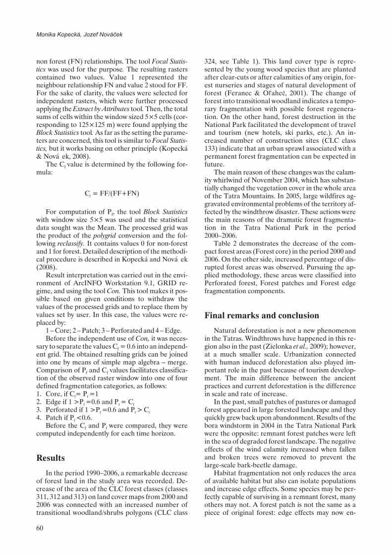
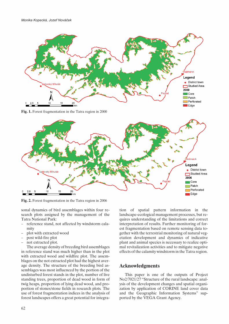
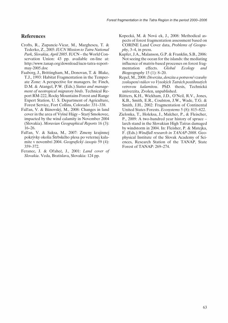
Table 2 demonstrates the decrease of the com-pact forest areas (Forest core) in the period 2000 and2006. On the other side, increased percentage of dis-rupted forest areas was observed. Pursuing the ap-plied methodology, these areas were classified intoPerforated forest, Forest patches and Forest edgefragmentation components.
Final remarks and conclusion
Natural deforestation is not a new phenomenonin the Tatras. Windthrows have happened in this re-gion also in the past (Zielonka et al., 2009); however,at a much smaller scale. Urbanization connectedwith human induced deforestation also played im-portant role in the past because of tourism develop-ment. The main difference between the ancientpractices and current deforestation is the differencein scale and rate of increase.
In the past, small patches of pastures or damagedforest appeared in large forested landscape and theyquickly grew back upon abandonment. Results of thebora windstorm in 2004 in the Tatra National Parkwere the opposite: remnant forest patches were leftin the sea of degraded forest landscape. The negativeeffects of the wind calamity increased when fallenand broken trees were removed to prevent thelarge-scale bark-beetle damage.
Habitat fragmentation not only reduces the areaof available habitat but also can isolate populationsand increase edge effects. Some species may be per-fectly capable of surviving in a remnant forest, manyothers may not. A forest patch is not the same as apiece of original forest: edge effects may now en-
60
Monika Kopecká, Jozef Nováèek

croach upon or even traverse the whole patch. What-ever the combination of biotic and abiotic changes is,the forest patches generally can no longer sustain theproduction of biodiversity it once had as a part of thelarger forest. Understanding of the possible conse-
quences of forest fragmentation is of great concernto conservation biologists and landscape ecologists.For example, Repel (2008) analysed breeding birdassemblage structure; nesting, foraging and migrat-ing guilds; bird and habitat relationship and the sea-
61
Forest fragmentation in the Tatra Region in the period 2000–2006
Table 2. Changes in forest fragmentation in the period 2000–2006
Fragmentation component2000 2006 Change 2000–2006
km2 % SA km2 % SA km2 % SA
Forest core 435.219 32.01 312.297 22.97 –122.922 –9.04
Perforated forest 14.765 1.09 15.500 1.14 0.735 0.05
Forest patches 73.313 5.39 77.000 5.66 3.687 0.27
Forest edge 37.687 2.77 38.562 2.84 0.875 0.07
Total 560.985 41.26 443.359 32.61 –117.626 –8.65
SA – study area
Table 1. CORINE land cover classes in the study area
CLC class*2000 2006 Change 2000–2006
number ofpolygons
total classarea (km2)
number ofpolygons
total classarea (km2)
number ofpolygons
total classarea (km2)
112 Discontinuous urban fabric 58 37.99 58 38.44 0 0.45
121 Industrial or commercial units 9 6.01 10 6.26 1 0.25
124 Airports 1 1.53 1 1.53 0 0
131 Mineral extraction sites 1 1.26 1 1.26 0 0
133 Construction sites 0 0 5 2.36 5 2.36
142 Sport and leisure facilities 13 10.07 13 10.26 0 0.19
211 Non-irrigated arable land 34 278.02 36 275.01 2 –3.01
222 Fruit trees and berry plantations 1 0.07 1 0.07 0 0
231 Pastures 92 128.49 91 126.98 –1 –1.51
242 Complex cultivation pattern 18 18.04 18 18.04 0 0
243 Land principally occupied byagriculture with significant areasof natural vegetation
69 34.42 69 34.14 0 –0.28
311 Broad-leaved forest 6 3.46 6 3.46 0 0
312 Coniferous forest 26 492.66 36 373.45 10 –119.21
313 Mixed forest 26 20.01 24 18.01 –2 –2
321 Natural grassland 27 81.43 27 81.43 0 0
322 Moors and heathland 38 91.11 38 91.11 0 0
324 Transitional woodland/shrubs 79 51.52 82 174.28 3 122.76
332 Bare rocks 7 60.96 7 60.96 0 0
333 Sparsely vegetated areas 40 40.70 40 40.70 0 0
412 Peatbogs 1 0.56 1 0.56 0 0
511 Water courses 2 1.42 2 1.42 0 0
512 Water bodies 1 0.01 1 0.01 0 0
*CLC classes are described in Feranec & O�ahe¾ (2001)
sonal dynamics of bird assemblages within four re-search plots assigned by the management of theTatra National Park:– reference stand, not affected by windstorm cala-
mity– plot with extracted wood– post wild-fire plot– not extracted plot.
The average density of breeding bird assemblagesin reference stand was much higher than in the plotwith extracted wood and wildfire plot. The assem-blages on the not extracted plot had the highest aver-age density. The structure of the breeding bird as-semblages was most influenced by the portion of theundisturbed forest stands in the plot, number of livestanding trees, proportion of dead wood in form oftwig heaps, proportion of lying dead wood, and pro-portion of stones/stone fields in research plots. Theuse of forest fragmentation indices in the analysis offorest landscapes offers a great potential for integra-
tion of spatial pattern information in thelandscape-ecological management processes, but re-quires understanding of the limitations and correctinterpretation of results. Further monitoring of for-est fragmentation based on remote sensing data to-gether with the terrestrial monitoring of natural veg-etation development and dynamics of indicativeplant and animal species is necessary to realize opti-mal revitalization activities and to mitigate negativeeffects of the calamity windstorm in the Tatra region.
Acknowledgments
This paper is one of the outputs of ProjectNo2/7021/27 “Structure of the rural landscape: anal-ysis of the development changes and spatial organi-zation by application of CORINE land cover dataand the Geographic Information Systems” sup-ported by the VEGA Grant Agency.
62
Monika Kopecká, Jozef Nováèek
Fig. 2. Forest fragmentation in the Tatra region in 2006
Fig. 1. Forest fragmentation in the Tatra region in 2000
References
Crofts, R., Zupancic-Vicar, M., Marghescu, T. &Tederko, Z., 2005: IUCN Mission to Tatra NationalPark, Slovakia, April 2005. IUCN – the World Con-servation Union: 43 pp. available on-line at:http://www.tanap.org/download/iucn-tatra-report-may-2005.doc
Faaborg, J., Brittingham, M., Donovan, T. & Blake,T.J., 1993: Habitat Fragmentation in the Temper-ate Zone: A perspective for managers. In: Finch,D.M. & Atangel, P.W. (Eds.) Status and manage-ment of neotropical migratory birds. Technical Re-port RM-222, Rocky Mountains Forest and RangeExpert Station, U. S. Department of Agriculture,Forest Service, Fort Collins, Colorado: 331–338.
Fal�an, V. & Bánovský, M., 2008: Changes in landcover in the area of Vyšné Hágy – Starý Smokovec,impacted by the wind calamity in November 2004(Slovakia). Moravian Geographical Reports 16 (3):16–26.
Fal�an, V. & Saksa, M., 2007: Zmeny krajinnejpokrývky okolia Štrbského plesa po veternej kala-mite v novembri 2004. Geografický èasopis 59 (4):359–372.
Feranec, J. & O�ahe¾, J., 2001: Land cover ofSlovakia. Veda, Bratislava, Slovakia: 124 pp.
Kopecká, M. & Nováèek, J., 2008: Methodical as-pects of forest fragmentation assessment based onCORINE Land Cover data, Problems of Geogra-phy, 3–4, in press.
Kupfer, J.A., Malanson, G.P. & Franklin, S.B., 2006:Not seeing the ocean for the islands: the mediatinginfluence of matrix-based processes on forest frag-mentation effects. Global Ecology andBiogeography 15 (1): 8–20.
Repel, M., 2008: Diverzita, denzita a potravné vzœahyzoskupení vtákov vo Vysokých Tatrách postihnutýchvetrovou kalamitou. PhD. thesis, Technickáuniverzita, Zvolen, unpublished.
Riitters, K.H., Wickham, J.D., O’Neil, R.V., Jones,K.B., Smith, E.R., Coulston, J.W., Wade, T.G. &Smith, J.H., 2002: Fragmentation of ContinentalUnited States Forests. Ecosystems 5 (8): 815–822.
Zielonka, T., Holeksa, J., Malcher, P., & Fleischer,P., 2009: A two-hundred year history of spruce –larch stand in the Slovakian High Tatras damagedby windstorm in 2004. In: Fleisher, P. & Matejka,F. (Eds.) Windfall research in TANAP-2008. Geo-physical Institute of the Slovak Academy of Sci-ences, Research Station of the TANAP, StateForest of TANAP: 269–274.
63
Forest fragmentation in the Tatra Region in the period 2000–2006