Embed Size (px)
Citation preview
August 2011
In Minnesota
For Updating The
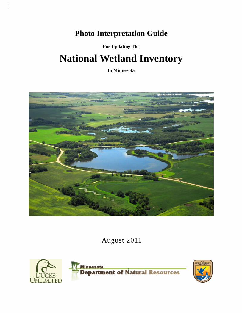
Photo Interpretation Guide
National Wetland Inventory
National Wetland Inventory
II
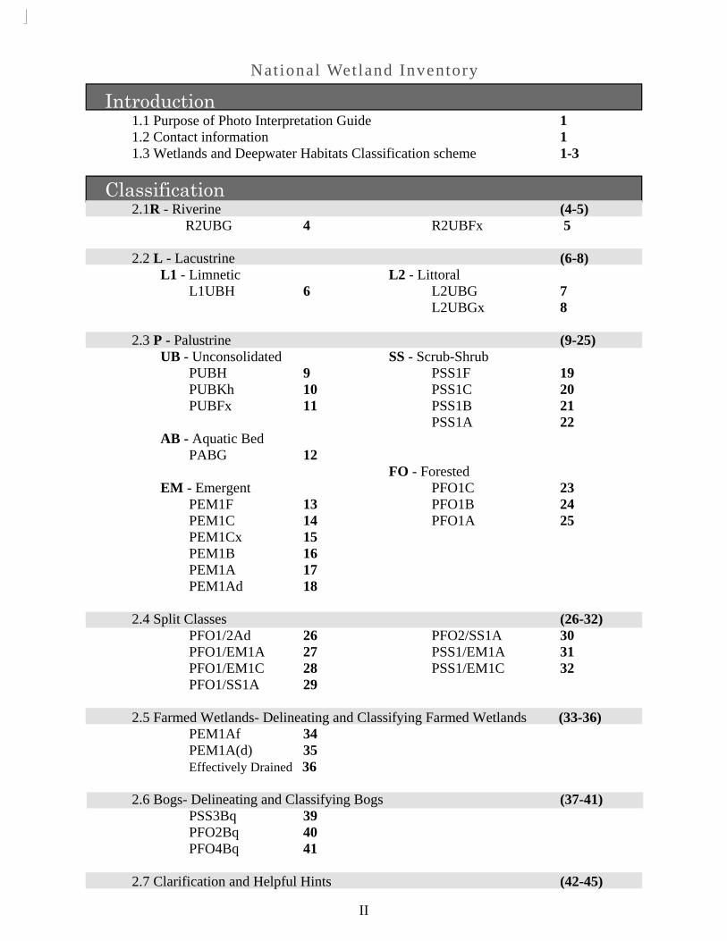
Introduction 1.1 Purpose of Photo Interpretation Guide 1 1.2 Contact information 1 1.3 Wetlands and Deepwater Habitats Classification scheme 1-3
Classification 2.1R - Riverine (4-5) R2UBG 4 R2UBFx 5 2.2 L - Lacustrine (6-8) L1 - Limnetic L2 - Littoral L1UBH 6 L2UBG 7 L2UBGx 8 2.3 P - Palustrine (9-25) UB - Unconsolidated SS - Scrub-Shrub PUBH 9 PSS1F 19 PUBKh 10 PSS1C 20 PUBFx 11 PSS1B 21 PSS1A 22 AB - Aquatic Bed PABG 12 FO - Forested EM - Emergent PFO1C 23 PEM1F 13 PFO1B 24 PEM1C 14 PFO1A 25 PEM1Cx 15 PEM1B 16 PEM1A 17 PEM1Ad 18 2.4 Split Classes (26-32) PFO1/2Ad 26 PFO2/SS1A 30 PFO1/EM1A 27 PSS1/EM1A 31 PFO1/EM1C 28 PSS1/EM1C 32 PFO1/SS1A 29 2.5 Farmed Wetlands- Delineating and Classifying Farmed Wetlands (33-36) PEM1Af 34 PEM1A(d) 35 Effectively Drained 36 2.6 Bogs- Delineating and Classifying Bogs (37-41) PSS3Bq 39 PFO2Bq 40 PFO4Bq 41 2.7 Clarification and Helpful Hints (42-45)

Nat ional Wetland Inventory
1.1 Purpose of Photo Interpretation Guide
This document is intended to serve as a visual key to be used as a training tool and refer-ence material for the photo interpreters updating the National Wetland Inventory (NWI) in Min-nesota. Its purpose is to:
This key does not attempt to show an exhaustive representation for all variations within each NWI class; only the most common or significant representations are included herein. Ad-ditional examples will be provided as the NWI update progresses throughout Minnesota. 1.2 Contact Information
Ducks Unlimited U.S. Fish and Wildlife Service MN DNR Robb Macleod Brian Huberty Molly Martin Ph. 734-623-2004 Ph. 612-713-5332 Ph. 218-327-4449 [email protected] [email protected] [email protected] 1.3 Wetland and Deepwater Habitats Classification Scheme For the update of the National Wetland Inventory in Minnesota the Cowardin et al. Classification System will be used as modified by the Minnesota DNR. See the Supplemental Guidance for the classification of Wetlands for the Update of the National Wetland inventory for Minnesota for further information on these modifications. For reference, a classification key has been provided on pages 2 and 3 of this document.
1
provide visual examples of each NWI class at the ground and aerial level (using different seasons and types) to assist the photo interpreters classifying the wetlands in Minnesota.

Nat ional Wetland Inventory
2
Fig 1.1.

Nat ional Wetland Inventory
3
Fig 1.2
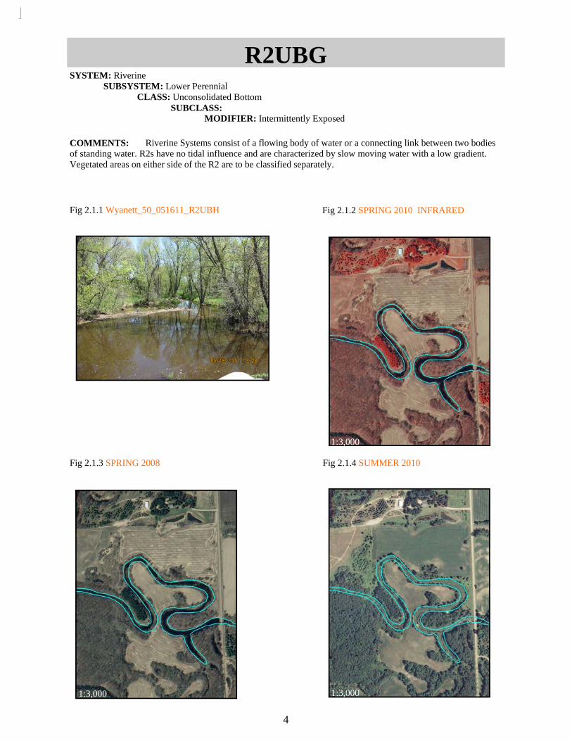
Fig 2.1.1 Wyanett_50_051611_R2UBH
Fig 2.1.2 SPRING 2010 INFRARED
Fig 2.1.3 SPRING 2008
R2UBG SYSTEM: Riverine SUBSYSTEM: Lower Perennial CLASS: Unconsolidated Bottom SUBCLASS: MODIFIER: Intermittently Exposed
COMMENTS: Riverine Systems consist of a flowing body of water or a connecting link between two bodies of standing water. R2s have no tidal influence and are characterized by slow moving water with a low gradient. Vegetated areas on either side of the R2 are to be classified separately.
4
Fig 2.1.4 SUMMER 2010
1:3,000
1:3,000 1:3,000
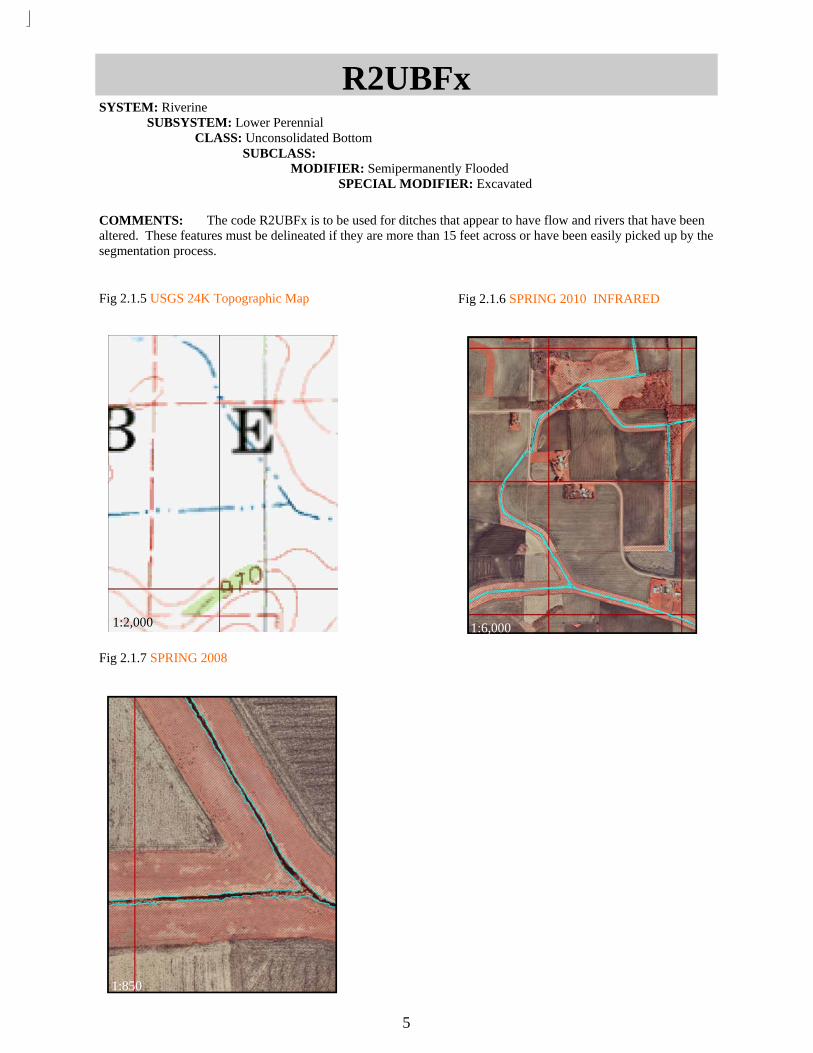
Fig 2.1.5 USGS 24K Topographic Map
Fig 2.1.6 SPRING 2010 INFRARED
Fig 2.1.7 SPRING 2008
R2UBFx SYSTEM: Riverine SUBSYSTEM: Lower Perennial CLASS: Unconsolidated Bottom SUBCLASS: MODIFIER: Semipermanently Flooded SPECIAL MODIFIER: Excavated
COMMENTS: The code R2UBFx is to be used for ditches that appear to have flow and rivers that have been altered. These features must be delineated if they are more than 15 feet across or have been easily picked up by the segmentation process.
5
1:6,000
1:850 1:3,000
1:2,000
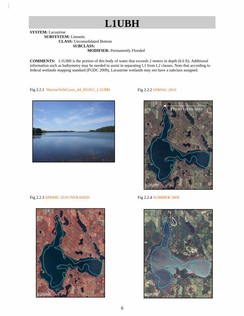
Fig 2.2.1 MarineOnStCroix_44_051811_L1UBH
Fig 2.2.2 SPRING 2010
Fig 2.2.3 SPRING 2010 INFRARED
Fig 2.2.4 SUMMER 2008
L1UBH SYSTEM: Lacustrine SUBSYSTEM: Limnetic CLASS: Unconsolidated Bottom SUBCLASS: MODIFIER: Permanently Flooded
COMMENTS: L1UBH is the portion of this body of water that exceeds 2 meters in depth (6.6 ft). Additional information such as bathymetry may be needed to assist in separating L1 from L2 classes. Note that according to federal wetlands mapping standard (FGDC 2009), Lacustrine wetlands may not have a subclass assigned.
6
Photo taken here
1:20,000
1:20,000 1:20,000

Fig 2.2.5Veseli_23_051811_L2UBH
Fig 2.2.7 SPRING 2010 INFRARED
Fig 2.2.8 SUMMER 2008
L2UBG SYSTEM: Lacustrine SUBSYSTEM: Littoral CLASS: Unconsolidated Bed SUBCLASS: MODIFIER: Intermittently Exposed
COMMENTS: There may be some L1 inside of this L2 class depending on the depth of water. L2 features must have a depth of less than 2m (6.6ft).
Fig 2.2.6 SPRING 2010
7
Photo taken here
1:2,500
1:2,500 1:2,500

Fig 2.2.9 Mayer_34_051711_L2UBHx
Fig 2.2.10 SPRING 2010
Fig 2.2.11 SPRING 2010 INFRARED
Fig 2.2.12 SUMMER 2008
L2UBGx SYSTEM: Lacustrine SUBSYSTEM: Littoral CLASS: Unconsolidated Bottom SUBCLASS: MODIFIER:Intermittently Exposed SPECIAL MODIFIER: Excavated
COMMENTS: The L2UB feature is not present before the 2010 images, indicating that it is manmade. Because of this an x (Excavated) special modifier must be included.
8
Photo taken here
1:3.000
1:3.000 1:3.000

Fig 2.3.1 StPaulEast_18_051711_PUBG
Fig 2.3.2 SPRING 2010
Fig 2.3.3 SPRING 2010 INFRARED
Fig 2.3.4 SUMMER 2008
PUBG SYSTEM: Palustrine SUBSYSTEM: CLASS: Unconsolidated Bed SUBCLASS: MODIFIER: Intermittently Exposed
COMMENTS: Open water with an area of less than 20 acres is classified as PUB. Because this PUB appears to be constantly flooded it is given an H (Permanently Flooded) water regime.
9
Photo taken here
1:2,000
1:2,000 1:2,000

Fig 2.3.6 SPRING 2010
Fig 2.3.7 SUMMER 2008
Fig 2.3.8 USGS 24K Topographic Map
PABKh SYSTEM: Palustrine SUBSYSTEM: CLASS: Aquatic Bed SUBCLASS: MODIFIER: Artificially Flooded SPECIAL MODIFIER: Diked/ Impounded
COMMENTS: Waste water treatment ponds are artificially flooded and are usually diked/impounded. Summer images should be used to determine if open water features have algal/moss/or vascular plants growing. If so they should be classified as an AB class rather than UB.
Fig 2.3.5 Mayer_23_051711_PUBKh
10
Photo ta
ken he
re
1:1,500
1:1,500
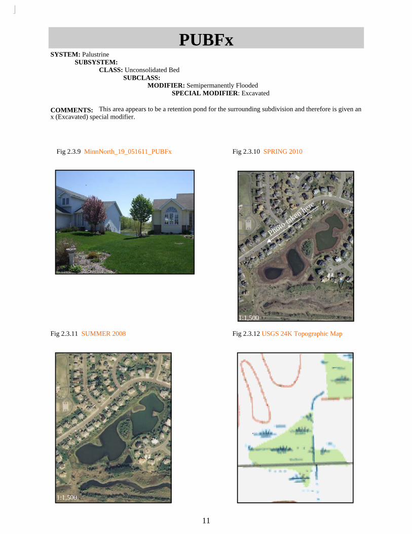
Fig 2.3.9 MinnNorth_19_051611_PUBFx
Fig 2.3.10 SPRING 2010
Fig 2.3.11 SUMMER 2008
Fig 2.3.12 USGS 24K Topographic Map
PUBFx SYSTEM: Palustrine SUBSYSTEM: CLASS: Unconsolidated Bed SUBCLASS: MODIFIER: Semipermanently Flooded SPECIAL MODIFIER: Excavated
COMMENTS: This area appears to be a retention pond for the surrounding subdivision and therefore is given an x (Excavated) special modifier.
11
Photo taken here
1:1,500
1:1,500

Fig 2.3.13 Wright_10_051811_PABG
Fig 2.3.14 SPRING 2010
Fig 2.3.15 SUMMER 2008
PABG SYSTEM: Palustrine SUBSYSTEM: CLASS: Aquatic Bed SUBCLASS: Floating Vascular MODIFIER: Intermittently Exposed
COMMENTS: AB wetlands are characterized by a pale green sheen that usually appears only in the summer.
12
Photo taken here
1:1,000
1:1,500

Fig 2.3.16 Hopkins_07_051711_PEM1F Fig 2.3.17 SPRING 2010
Fig 2.3.18 SPRING 2010 INFRARED
Fig 2.3.19 SUMMER 2008
PEM1F SYSTEM: Palustrine SUBSYSTEM: CLASS: Emergent SUBCLASS: Persistent MODIFIER: Semipermanently Flooded
COMMENTS: Emergents tend to appear smoother and brighter than surrounding vegetation. Dark spotted areas visible within the emergent vegetation indicate surface water. The level of flooding in this wetland does not appear to fluctuate much throughout the seasons but may dry out in drought years, indicating an F (Semipermanently Flooded) rather than a C (Seasonally Flooded) water regime. Note that EM present throughout most years will be given a 1 (Persistent) subclass.
13
Photo taken here
1:500
1:500 1:500
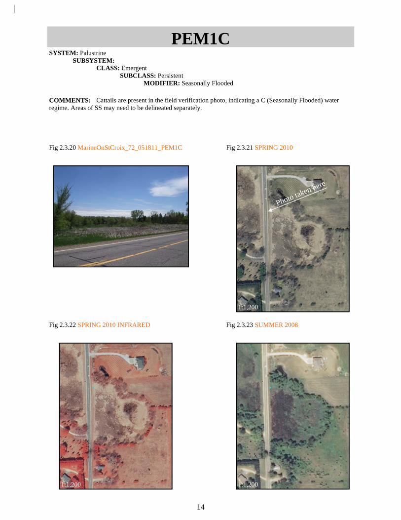
Fig 2.3.20 MarineOnStCroix_72_051811_PEM1C
Fig 2.3.21 SPRING 2010
Fig 2.3.22 SPRING 2010 INFRARED
Fig 2.3.23 SUMMER 2008
PEM1C SYSTEM: Palustrine SUBSYSTEM: CLASS: Emergent SUBCLASS: Persistent MODIFIER: Seasonally Flooded
COMMENTS: Cattails are present in the field verification photo, indicating a C (Seasonally Flooded) water regime. Areas of SS may need to be delineated separately.
14
Photo taken here
1:1,200
1:1,200 1:1,200
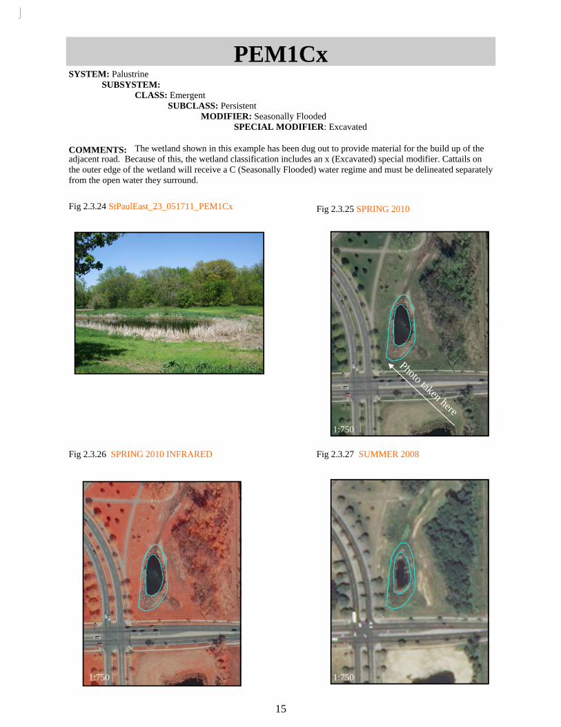
Fig 2.3.24 StPaulEast_23_051711_PEM1Cx
Fig 2.3.25 SPRING 2010
Fig 2.3.26 SPRING 2010 INFRARED
Fig 2.3.27 SUMMER 2008
PEM1Cx SYSTEM: Palustrine SUBSYSTEM: CLASS: Emergent SUBCLASS: Persistent MODIFIER: Seasonally Flooded SPECIAL MODIFIER: Excavated
COMMENTS: The wetland shown in this example has been dug out to provide material for the build up of the adjacent road. Because of this, the wetland classification includes an x (Excavated) special modifier. Cattails on the outer edge of the wetland will receive a C (Seasonally Flooded) water regime and must be delineated separately from the open water they surround.
15
Photo taken here
1:750
1:750 1:750

Fig 2.3.28 SUMMER 2008
Fig 2.3.31 SPRING 2010
PEM1B SYSTEM: Palustrine SUBSYSTEM: CLASS: Emergent SUBCLASS: Persistent MODIFIER: Saturated
COMMENTS: Saturated Emergent wetlands will not have surface water. The presence of an open water moat or an floating mats that moves around the body of water are good indicators of an emergent saturated wetland. Use the most recent imagery when delineating floating mats.
16
Fig 2.3.30 SUMMER (unknown year)
1:10,000
Fig 2.3.29 SUMMER 2009
1:10,000 1:10,000

Fig 2.3.32 MarineOnStCroix_01_0051811_PEM1A
Fig 2.3.33 SPRING 2010
Fig 2.3.34 SPRING 2010 INFRARED
Fig 2.3.35 SUMMER 2008
PEM1A SYSTEM: Palustrine SUBSYSTEM: CLASS: Emergent SUBCLASS: Persistent MODIFIER: Temporarily Flooded
COMMENTS: The EM wetland shown in this example is given an A (Temporarily Flooded) water regime because although water usually lies below the surface, water may be visible for brief periods during the spring. A wetland of this type may have a visible depression or be discolored from the surrounding vegetation.
17
Phot
o tak
en h
ere
1:750
1:750 1:750

Fig 2.3.36 Wyanett_20_051611_PEM1Ad
Fig 2.3.37 SPRING 2010
Fig 2.3.38 SUMMER 2008
Fig 2.3.39 USGS 24k Topographic Map
PEM1Ad SYSTEM: Palustrine SUBSYSTEM: CLASS: Emergent SUBCLASS: Persistent MODIFIER: Temporarily Flooded SPECIAL MODIFIER: Partly Drained/Ditched
COMMENTS: A ditch can be seen running through this wetland in both images and topographic map. A d (Partly Drained/Ditched) special modifier should be included in the classification of wetlands where a ditch is clearly visible. A topographic map may be helpful in determining if a wetland is partly drained/ditched.
18
Photo taken here
1:1,250
1:1,250

Fig 2.3.40 Mayer_19_051711_PSS1F
Fig 2.3.41 SPRING 2010
Fig 2.3.42 SPRING 2010 INFRARED
Fig 2.3.43 SUMMER 2008
PSS1F SYSTEM: Palustrine SUBSYSTEM: CLASS: Scrub-Shrub SUBCLASS: Broad-Leaved Deciduous MODIFIER: Semipermanently Flooded
COMMENTS: Wetlands characterized as Scrub-Shrub (SS) must be less than 20 ft (6m) tall and can be distin-guished in aerial images by a rough texture. The SS shown appears to be very wet in both the spring aerial images and the field verification images. Because it is unlikely that SS could survive in a permanently flooded area, this wetland is given an F (Semipermanently Flooded) water regime.
19
Photo taken here
1:2,000
1:2,000 1:2,000

Fig 2.3.44 Mayer_32_051711_PSS1C
Fig 2.3.45 SPRING 2010
Fig 2.3.46 SPRING 2010 INFRARED
Fig 2.3.47 SUMMER 2008
PSS1C SYSTEM: Palustrine SUBSYSTEM: CLASS: Scrub-Shrub SUBCLASS: Broad-Leaved Deciduous MODIFIER: Seasonally Flooded
COMMENTS: SS and EM classifications can be distinguished from one another by their different textures. SS will appear coarse or rough while EM will appear smooth. This area is given a C (Seasonally Flooded) water re-gime because there appears to be a significant amount of water in the spring with less flooding in the summer.
20
Photo taken here
1:2,000
1:2,000 1:2,000

Fig 2.3.48 Wyanett_70_051611_PSS1A
Fig 2.3.49 SPRING 2010
Fig 2.3.50 SPRING 2010 CLOSE UP
Fig 2.3.51 SUMMER 2008
PSS1A SYSTEM: Palustrine SUBSYSTEM: CLASS: Scrub-Shrub SUBCLASS: Broad-Leaved Deciduous MODIFIER: Temporarily Flooded
COMMENTS: Water regimes tend to get less wet as distance from a body of water increase. In this case, SS near the body of water should have a C (Seasonally Flooded) because flooding is visible in both the spring and summer, while the area closer to the road has only some flooding visible during the spring and should be assigned an A (Temporarily Flooded) water regime. Note that in thick stands of vegetation flooding may not be easily seen.
21
Photo taken here
1:3,000
1:3,000 1:3,000
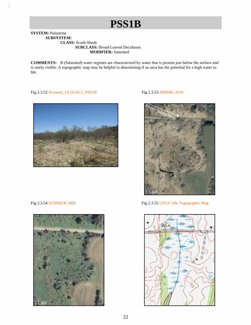
Fig 2.3.52 Wyanett_14_051611_PSS1B
Fig 2.3.53 SPRING 2010
Fig 2.3.54 SUMMER 2008
PSS1B SYSTEM: Palustrine SUBSYSTEM: CLASS: Scrub-Shrub SUBCLASS: Broad-Leaved Deciduous MODIFIER: Saturated
COMMENTS: B (Saturated) water regimes are characterized by water that is present just below the surface and is rarely visible. A topographic map may be helpful in determining if an area has the potential for a high water ta-ble.
Fig 2.3.55 USGS 24K Topographic Map
22
Photo taken here
1:1,000
1:1,000
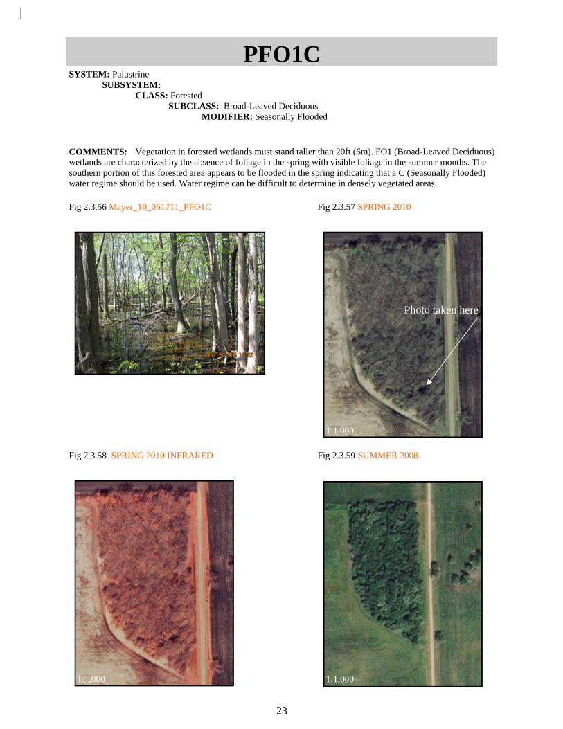
Fig 2.3.58 SPRING 2010 INFRARED
Fig 2.3.59 SUMMER 2008
PFO1C SYSTEM: Palustrine SUBSYSTEM: CLASS: Forested SUBCLASS: Broad-Leaved Deciduous MODIFIER: Seasonally Flooded
COMMENTS: Vegetation in forested wetlands must stand taller than 20ft (6m). FO1 (Broad-Leaved Deciduous) wetlands are characterized by the absence of foliage in the spring with visible foliage in the summer months. The southern portion of this forested area appears to be flooded in the spring indicating that a C (Seasonally Flooded) water regime should be used. Water regime can be difficult to determine in densely vegetated areas.
Fig 2.3.57 SPRING 2010
Fig 2.3.56 Mayer_10_051711_PFO1C
23
Photo taken here
1:1,000
1:1,000 1:1,000

Fig 2.3.60 Wyanett_21_051611_PFO1B
Fig 2.3.61 SPRING 2010
Fig 2.3.62 SUMMER 2008
PFO1B SYSTEM: Palustrine SUBSYSTEM: CLASS: Forested SUBCLASS: Broad-Leaved Deciduous MODIFIER: Saturated
COMMENTS: When surface water is not usually present but photos and topography suggests that it is often near the surface, a B (Saturated) water regime should be assigned.
24
Photo taken here
1:1,500
1:1,500

Fig 2.3.63 Bloomington_08_051811_PFO1A
Fig 2.3.64 SPRING 2010
Fig 2.3.65 SPRING 2010 INFRARED
Fig 2.3.66 SUMMER 2008
PFO1A SYSTEM: Palustrine SUBSYSTEM: CLASS: Forested SUBCLASS: Broad-Leaved Deciduous MODIFIER: Temporarily Flooded
COMMENTS: A (Temporarily Flooded) water regimes are often found within a floodplain where surface water only appears briefly.
25
Photo taken here
1:1,000
1:1,000 1:1,000

Fig 2.4.1 Wyanett_59_051611_PFO1/2Ad
Fig 2.4.2 SPRING 2010
Fig 2.4.3 SUMMER 2008
Fig 2.4.4 USGS 24K Topographic Map
PFO1/2Ad SYSTEM: Palustrine SUBSYSTEM: CLASS: Forested SUBCLASS: Broad-Leaved Deciduous/ Needle-Leaved Deciduous MODIFIER: Temporarily Flooded SPECIAL MODIFIER: Partially Drained/Ditched
COMMENTS: Although mixed classes should be avoided when possible, they are sometimes necessary when classes cannot be separated from one another.
26
Photo taken here 1:2,000
1:2,000

Fig 2.4.5 MarineOnStCroix_47_051811_PFO1/EM1A
Fig 2.4.6 SPRING 2010
Fig 2.4.7 SPRING 2010 INFRARED
Fig 2..4.8 SUMMER 2008
PFO1/EM1A SYSTEM: Palustrine SUBSYSTEM: CLASS: Forested/ Emergent SUBCLASS: Broad-Leaved Deciduous/ Persistent MODIFIER: Temporarily Flooded
COMMENTS: FO/EM mixed classes have vegetation greater than 20ft (6m) throughout an area with an under-story of emergent vegetation. When coding mixed classes, the class with the greatest vegetation height will be named first. For example, FO/SS, FO/EM, SS/EM are correctly coded.
27
Photo taken here
1:500
1:500 1:500

Fig 2.4.9 StPaulWest_02_051611_PFO1/EM1C
Fig 2.4.10 SPRING 2010
Fig 2.4.11 SPRING 2010 INFRARED
Fig 9.4.12 SUMMER 2008
PFO1/EM1C SYSTEM: Palustrine SUBSYSTEM: CLASS: Forested/ Emergent SUBCLASS: Broad-Leaved Deciduous/ Persistent MODIFIER: Seasonally Flooded
COMMENTS: EM should be clearly seen though leaf-off forested wetlands (FO) in spring imagery in FO/EM mixed classes.
28
Photo taken here
1:2,000
1:2,000 1:2,000

Fig 2.4.13 Hopkins_37_051711_PFO1/SS1A
Fig 2.4.14 SPRING 2010
Fig 2.4.15 SPRING 2010 INFRARED
Fig 2.4.16 SUMMER 2008
PFO1/SS1A SYSTEM: Palustrine SUBSYSTEM: CLASS: Forested/ Scrub-Shrub SUBCLASS: Broad-Leaved Deciduous/ Broad-Leaved Deciduous MODIFIER: Temporarily Flooded
COMMENTS: An FO/SS mixed class has woody vegetation less than 20ft (6m) in height and greater than 20ft (6m) intermixed. The EM in these photos should be classified and digitized separately.
29
Photo taken here
1:750
1:750 1:750

Fig 2.4.17 Wyanett_46_051611_PFO2/SS1A
Fig 2.4.18 SPRING 2010
Fig 2.4.19 SUMMER 2008
PFO2/SS1A SYSTEM: Palustrine SUBSYSTEM: CLASS: Forested/ Scrub-Shrub SUBCLASS: Needle-Leaved Deciduous/ Broad-Leaved Deciduous MODIFIER: Temporarily Flooded
COMMENTS: If possible, separate FO and SS class. Vegetation taller than 20ft (6m) should appear green in spring and summer images, while shorter vegetation only appears green during summer months.
30
Photo taken here
1:2,000
1:2,000
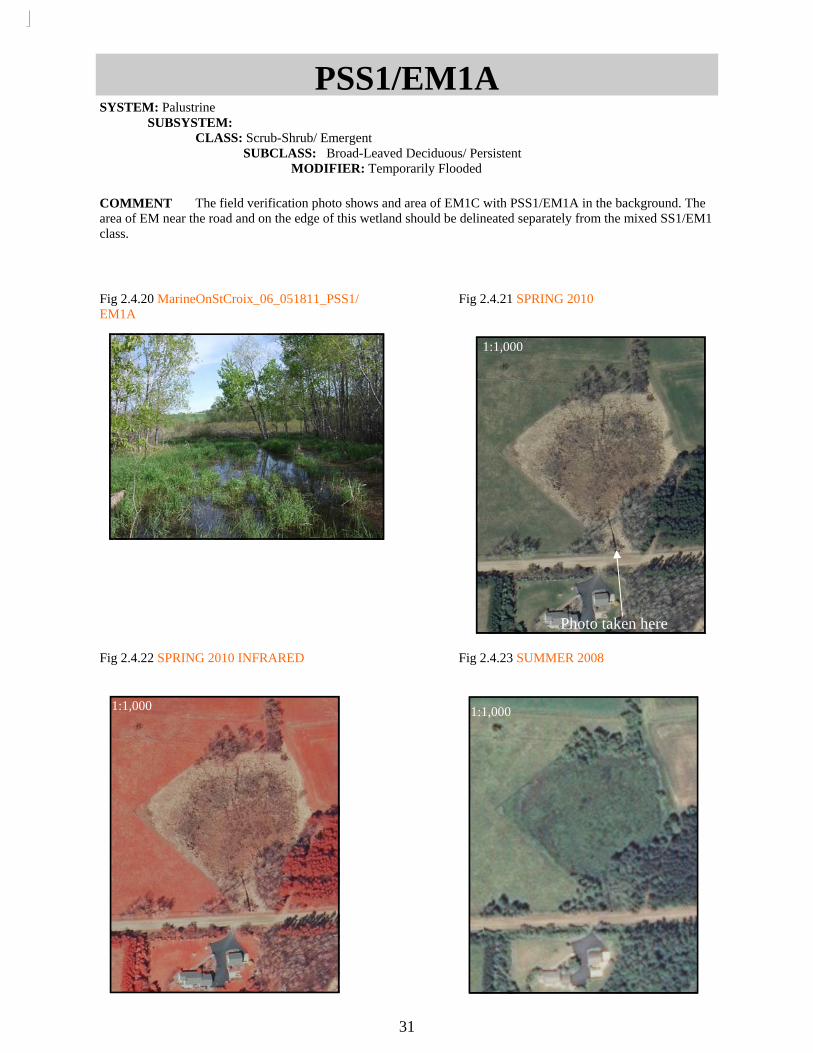
Fig 2.4.20 MarineOnStCroix_06_051811_PSS1/EM1A
Fig 2.4.22 SPRING 2010 INFRARED
Fig 2.4.23 SUMMER 2008
PSS1/EM1A SYSTEM: Palustrine SUBSYSTEM: CLASS: Scrub-Shrub/ Emergent SUBCLASS: Broad-Leaved Deciduous/ Persistent MODIFIER: Temporarily Flooded
COMMENT The field verification photo shows and area of EM1C with PSS1/EM1A in the background. The area of EM near the road and on the edge of this wetland should be delineated separately from the mixed SS1/EM1 class.
Fig 2.4.21 SPRING 2010
31
Photo taken here
1:1,000
1:1,000 1:1,000

Fig 2.4.24 Bloomington_19_051811_PSS1/EM1C
Fig 2.4.25 SPRING 2010
Fig 2.4.26 SPRING 2010 INFRARED
Fig 2.4.27 SUMMER 2008
PSS1/EM1C SYSTEM: Palustrine SUBSYSTEM: CLASS: Scrub-Shrub/ Emergent SUBCLASS: Broad-Leaved Deciduous/ Persistent MODIFIER: Seasonally Flooded
COMMENTS: EM vegetation will be visibly brighter underneath SS.
32
Photo taken here
1:750
1:750 1:750
33
Delineating and Classifying Farmed Wetlands Explanation: The definition of a farmed wetland (f) from Dahl et al. (2009) is: “Farmed wetlands occur where the soils surface has been mechanically or physically altered for production of crops, but hydrophytes will become reestablished if farming is discontinued. Farmed wetlands will be identified by using the attributes Pf (Palustrine farmed). Cultivated cranberry bogs many be classified as Palustrine farmed wetland or as Palustrine scrub/shrub – farmed” In Minnesota the Pf code will not be used. Instead, all farmed wetlands that meet the rules described below will be classified as PEM1Af . Wetlands in farm fields that have wetland vegetation for at least two of the three summer images will be classified as PEM1Ad (without the f modifier).
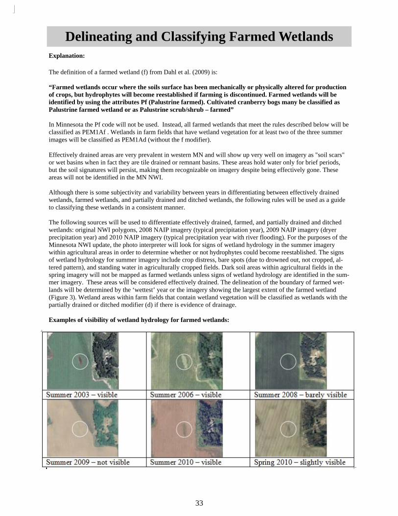
Effectively drained areas are very prevalent in western MN and will show up very well on imagery as "soil scars" or wet basins when in fact they are tile drained or remnant basins. These areas hold water only for brief periods, but the soil signatures will persist, making them recognizable on imagery despite being effectively gone. These areas will not be identified in the MN NWI. Although there is some subjectivity and variability between years in differentiating between effectively drained wetlands, farmed wetlands, and partially drained and ditched wetlands, the following rules will be used as a guide to classifying these wetlands in a consistent manner. The following sources will be used to differentiate effectively drained, farmed, and partially drained and ditched wetlands: original NWI polygons, 2008 NAIP imagery (typical precipitation year), 2009 NAIP imagery (dryer precipitation year) and 2010 NAIP imagery (typical precipitation year with river flooding). For the purposes of the Minnesota NWI update, the photo interpreter will look for signs of wetland hydrology in the summer imagery within agricultural areas in order to determine whether or not hydrophytes could become reestablished. The signs of wetland hydrology for summer imagery include crop distress, bare spots (due to drowned out, not cropped, al-tered pattern), and standing water in agriculturally cropped fields. Dark soil areas within agricultural fields in the spring imagery will not be mapped as farmed wetlands unless signs of wetland hydrology are identified in the sum-mer imagery. These areas will be considered effectively drained. The delineation of the boundary of farmed wet-lands will be determined by the ‘wettest’ year or the imagery showing the largest extent of the farmed wetland (Figure 3). Wetland areas within farm fields that contain wetland vegetation will be classified as wetlands with the partially drained or ditched modifier (d) if there is evidence of drainage. Examples of visibility of wetland hydrology for farmed wetlands:

Fig 2.5.1 SUMMER 2008
Fig 2.5.2 SUMMER 2009
Fig 2.5.3 SPRING 2010 INFRARED
Fig 2.5.4 SUMMER 2010
PEM1Af SYSTEM: Palustrine SUBSYSTEM: CLASS: Emergent SUBCLASS: Persistent MODIFIER: Temporarily Flooded SPECIAL MODIFIER: Farmed
COMMENTS: An f (Farmed) special modifier is given when an area appears to be farmed most years but is visibly wet in two of the three image years (summer). There will often be only agricultural vegetation present; however, if not farmed, wetland vegetation would return.
34

Fig 2.5.5 SUMMER 2008
Fig 2.5.6 SUMMER 2009
Fig 2.5.7 SPRING 2010
Fig 2.5.8 SUMMER 2010
PEM1A(d) SYSTEM: Palustrine SUBSYSTEM: CLASS: Emergent SUBCLASS: Persistent MODIFIER: Temporarily Flooded SPECIAL MODIFIER: Partially Drained/Ditched
COMMENTS: An area is an emergent wetland (PEM1A) if the original NWI classification identified it as a wet-land and there is still wetland vegetation in one of three image years (summer) or if wetland vegetation is present in two of three image years. Because this wetland is located in the middle of a farm field it can be assumed that it has been tiled or ditched in the past. A d (Partially Drained/Ditched) modifier may or may not be given.
35

Fig 2.5.9 Ground Photo of Tile Drainage
Fig 2.5.10 SPRING 2010
Fig 2.5.11 SPRING 2010 INFRARED
Effectively Drained COMMENTS: These areas are identified by a dark soil and soil scars in agricultural areas which indicate past wetland hydrology, but are effectively drained and do not currently support wetland vegetation. Summer imagery should be free of most crop stress in at least two of the three dates. Note the tile drain in the ground photo and the dark signature in the aerial photos. These areas will not be delineated in the MN NWI wetlands layer.
36
Effectively Drained Effectively Drained

Explanation: A new special modifier has been proposed specifically for the Minnesota NWI update. Interpretation beyond what is typically required for the NWI is needed to effectively separate the peatland community class. The peatland community crosses the PEM, PSS, and PFO Cowardin classes (typical vegetation includes sphagnum [peat moss], leatherleaf, sedges, black spruce, and tamarack). NOTE: This class is most closely related the Eggers and Reed bog classes, but the relationship is not expected to be perfect. According to Eggers and Reed, bogs have the following plant characteristics: Wetlands interpreted as having a peatland signature, as described in Eggers and Reed, should be assigned a B (Saturated) water regime and the q (Peatland) special modifier. Coniferous bogs composed of tamarack and/or black spruce dominant trees growing on a continuous sphagnum mat should be coded as PFO2Bq or PFO4Bq, re-spectively. Open bogs with ericaceous and evergreen shrubs growing on a sphagnum moss mat layer will be as-signed PSS3Bq. Effort should be made to separate coniferous bogs (PFO2Bq/PFO4Bq) from coniferous swamp (PFO2B/PFO4B), which may have tamarack without sphagnum, and thus would not receive a q modifier. The presence of a sphagnum mat and ericaceous shrubs can usually be photo-interpreted. In some cases, the tree canopy may be too dense to view the underlying vegetation. However, depending upon the characteristics of the tree canopy, the presence of a sphagnum mat can be inferred. The Native Plant Community Classification System refers to some wetlands with extensive sphagnum coverage as poor fens; Eggers and Reed do not make this dis-tinction. These poor fens are difficult to separate from bogs without detailed field studies. In fact, fens and bogs may occur within the same wetland complex.
Delineating and Classifying Peatlands
37
Tamarack (PFO2) and/or black spruce (PFO4) are dominant; growing on a continu-
ous sphagnum moss mat and acid, peat soils
Shrubs are ericaceous and evergreen (PSS3, PSS4) growing on a sphagnum moss mat layer; peat soils are acidic
Sphagnum moss mat on acid peat soils; leatherleaf, pitcher plants, certain sedges, and other herbaceous species (PEM) tolerant of low nutrient conditions may be pre-

38
Delineating and Classifying Peatlands

Fig 2.6.1 Wyanett_44_051611_PSS3C
Fig 2.6.2 SPRING 2010
Fig 2.6.4 SUMMER 2008
PSS3Bq SYSTEM: Palustrine SUBSYSTEM: CLASS: Scrub-Shrub SUBCLASS: Broad-Leaved Evergreen MODIFIER: Saturated SPECIAL MODIFIER: Bog (Specific to Minnesota)
COMMENTS: Mats of floating vegetation are often composed of Broad-Leaved Evergreen shrubs such as bog rosemary and Labrador tea. Because of this, these wetland features are classified as PSS3. Broad-Leaved Ever-green vegetation can be differentiated from emergent vegetation using infrared images. SS3 vegetation may also appear significantly darker than surrounding EM in spring images.
Fig 2.6.3 SPRING 2010 INFRARED
39
Phot
o ta
ken
here
1:1,000
1:1,000 1:1,000

Fig 2.6.5 SUMMER 2008
Fig 2.6.6 SPRING 2010
Fig 2.6.7 SPRING 2010 INFRARED
Fig 2.6.8 FALL 2010 GROUND PHOTO
PFO2Bq SYSTEM: Palustrine SUBSYSTEM: CLASS: Forested SUBCLASS: Needle-Leaved Deciduous MODIFIER: Saturated SPECIAL MODIFIER: Bog (Specific to Minnesota)
COMMENTS: Tamarack is a bog pioneer species. It is a Needle-Leaved Deciduous tree that appears medium red/orange in CIR images compared to the saturated red color of Needle-Leaved Evergreen trees. On aerial images tamarack will have a softer, feathered appearance.
40
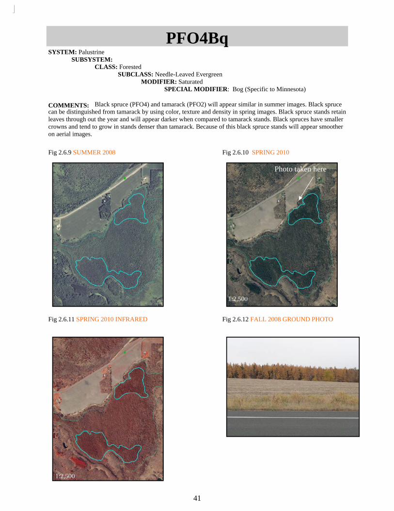
Fig 2.6.9 SUMMER 2008 Fig 2.6.10 SPRING 2010
Fig 2.6.11 SPRING 2010 INFRARED
Fig 2.6.12 FALL 2008 GROUND PHOTO
PFO4Bq SYSTEM: Palustrine SUBSYSTEM: CLASS: Forested SUBCLASS: Needle-Leaved Evergreen MODIFIER: Saturated SPECIAL MODIFIER: Bog (Specific to Minnesota)
COMMENTS: Black spruce (PFO4) and tamarack (PFO2) will appear similar in summer images. Black spruce can be distinguished from tamarack by using color, texture and density in spring images. Black spruce stands retain leaves through out the year and will appear darker when compared to tamarack stands. Black spruces have smaller crowns and tend to grow in stands denser than tamarack. Because of this black spruce stands will appear smoother on aerial images.
41
Photo taken here
1:2,500
1:2,500

Clarification and Helpful Hints
42
R2 is the only riverine subsystem used in Minnesota. The most common are R2UBG for rivers, R2UBH for larger rivers and R2UBFx for ditches with flow, or smaller rivers that have been redirected. An h (Diked/Impounded) modifier may be given in some cases, the Mississippi River is a good example of this of a river that will always have an h modifier.
Only PEM, PSS, and PFO palustrine wetlands get a subclass. EM will be 1 (persistent) in all palustrine
systems and 2 (non-persistent) in most littoral subsystems. PSS subclasses include 1,2,3 and 4. PFO sub-classes include 1,2, and 4.
All classified wetlands must have a valid water regime. Valid water regimes include A, B, C, F, G, H,
and K. B water regimes are very rare and should be used with caution. G water regimes are mainly used with Riverine Systems, PUB wetlands that stay flooded and Littoral Systems. H water regimes are mainly used for Large rivers and lakes.
r (Artificial) and s (Spoil) special modifiers are not used. When checking the topology make sure that you are checking for the entire extent and not just the visible
extent. It is helpful to re-validate the topology at the end of fixing the errors to make sure that new errors haven’t been created.
Watch out for unattributed polygons within an attributed wetland. This is okay if it is actually an upland
and not just a polygon missed when merging. Make sure that you are cutting and merging from the existing segments and not creating features.
A: (Temporarily Flooded)- Floods in spring during most years, dry for the rest of the year. Emergent wetland with a bright signature (usually reed canary grass). Smoother in texture and often darker in color than C or F water regimes.
B: (Saturated)- Substrate is saturated for most of the year, rarely floods. To be used with all PSS3, floating mats,
C: (Seasonally Flooded)- Cattails, flooded in spring and darker in summer. Usually rough in texture. May have animal trails throughout.
F- (Semi-Permanently Flooded)- Flooded throughout the year in most years. Found around lakes and ponds. Likely has open patches of water.
G: (Intermittently Exposed)- Used for rivers, ponds and littoral systems.
H: (Permanently Flooded)- Used for large rivers and large limnetic systems.
Water Regimes

L2EM2/ABG
43
Fig 2.7.1 SUMMER 2008
Fig 2.7.2 SPRING 2010 INFRARED
Fig 2.7.3 SUMMER 2010
Fig 2.7.4 SUMMER 2011
SYSTEM: Lacustrine SUBSYSTEM: Littoral CLASS: Emergent/Aquatic Bed SUBCLASS: Nonpersistent MODIFIER: Intermittently Exposed
COMMENTS: This littoral area is classified as a split class because aquatic bed and non-persistent emergent vegetation each occupy more than 30% of the wetland area.
1:1,500
1:1,500 1:1,500
1:1,500
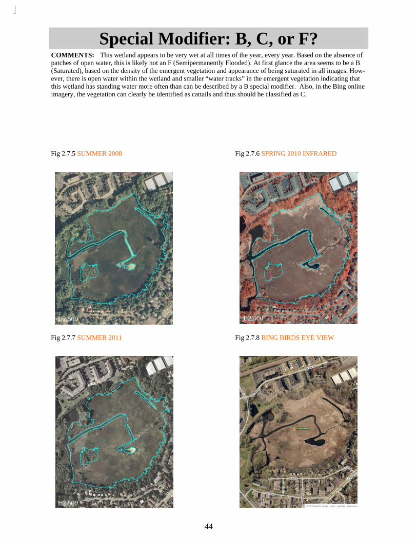
Special Modifier: B, C, or F?
44
Fig 2.7.5 SUMMER 2008
Fig 2.7.6 SPRING 2010 INFRARED
Fig 2.7.7 SUMMER 2011
Fig 2.7.8 BING BIRDS EYE VIEW
COMMENTS: This wetland appears to be very wet at all times of the year, every year. Based on the absence of patches of open water, this is likely not an F (Semipermanently Flooded). At first glance the area seems to be a B (Saturated), based on the density of the emergent vegetation and appearance of being saturated in all images. How-ever, there is open water within the wetland and smaller “water tracks” in the emergent vegetation indicating that this wetland has standing water more often than can be described by a B special modifier. Also, in the Bing online imagery, the vegetation can clearly be identified as cattails and thus should be classified as C.
1:2,500 1:2,500
1:2,500

Special Modifier: B or F?
45
Fig 2.7.9 SUMMER 2008
Fig 2.7.10 SUMMER 2009
Fig 2.7.11 SUMMER 2010
Fig 2.7.12 BING
COMMENTS: The pockets of emergent vegetation in this lake appear to be floating mats. However, because the pockets of vegetation do not move from year to year we assume that they are not floating. Thus, they would be classified as PEM1F rather than PEM1B.


![Lesson 3 Seafood: Wild and Farmed · Lesson 3: Seafood: Wild and Farmed | [1] 2016 Johns Hopkins University Lesson 3 Seafood: Wild and Farmed [Lesson Duration: 45 minutes, plus 15](https://img.dokumen.tips/doc/110x75/5f6dcd508293d73bc7753858/lesson-3-seafood-wild-and-farmed-lesson-3-seafood-wild-and-farmed-1-2016.jpg)