Embed Size (px)
Citation preview


The Western Governors’ Association wishes to thank Vice Admiral Conrad C.Lautenbacher, Administrator of the National Oceanic and Atmospheric Administration,for his vision and leadership in recognizing the value and importance of the NationalIntegrated Drought Information System. NOAA’s partnership with the WGA madethis report possible.
“With drought causing between $6 billion and $8 billion a year in direct estimatedlosses to the U.S. economy and devastating impacts on our society, we cannot overlook the need for science to predict, monitor and mitigate this phenomenon. By creating a comprehensive drought information network and setting the state forthe first national drought policy, we can provide decision-makers with the best toolsto manage our natural resources and ensure an adequate supply of clean water forour nation. Drought monitoring and prediction are key to the earth observation system envisioned by world leaders.
Where there is water, there is life. We must deliver the best science and the mostwell-coordinated program possible to address this challenge. The NIDIS will providethe framework for dealing with the drought conditions that have ravaged our countryin recent years. The NIDIS is the early warning system for the 21st century that willimprove our existing capabilities in monitoring and forecasting drought.”
Vice Admiral Conrad C. Lautenbacher, Jr., Undersecretary of Commercefor Oceans and Atmosphere; NOAA Administrator
1895 1905 1915 1925 1935 1945 1955 1965 1975 1985 1995
60
50
40
30
20
10
0
%
Drought is a normal part of climate
Percent Area of the United States in Severe and Extreme DroughtSource: National Climatic Data Center/NOAA

Creating a Drought Early Warning System for the 21st CenturyThe National Integrated Drought Information System
Executive Summary“Drought is the most obstinate and pernicious of the dramatic events that Nature conjures up. It can last
longer and extend across larger areas than hurricanes, tornadoes, floods and earthquakes…causing hundreds ofmillions of dollars in losses, and dashing hopes and dreams.”
— National Drought Policy Commission Report, May 2000
In 1996, the Western Governors set an aggressive goal to change the way our nation prepares for andresponds to droughts. Subsequent efforts by the Western Governors’ Association (WGA) led to theCongressional creation of the National Drought Policy Commission (NDPC), which issued its recommendationsin May 2000 to establish such a national policy. Among its recommendations, the Commission called for“Improving collaboration among scientists and managers to enhance the effectiveness of observation networks,monitoring, prediction, information delivery, and applied research and to foster public understanding of and preparedness for drought.”
The Western Governors agree that improved monitoring and forecasting is fundamental to a proactivenational drought policy. Better science will lead to better and more timely decisions, thus reducing or mitigatinga drought’s impacts. In February 2003, WGA’s Lead Governor for Drought, Mike Johanns of Nebraska, met withNational Oceanic and Atmospheric Administration (NOAA) Administrator, Vice Admiral Conrad Lautenbacher, todiscuss a partnership between NOAA and WGA to develop a vision and recommendations for establishing animproved drought monitoring and forecasting system. The partnership began in April 2003, and this report,Creating A Drought Early Warning System for the 21st Century: The National Integrated Drought Information System,is the first product of that partnership.
We highlight two key components of NIDIS described in this report that will be critical to its successfulimplementation: 1. improve and expand the compilation of reliable data on the various indicators of droughts, from both the
physical/hydrological data (such as a national surface observing network) to the socio-economic and environmental impacts data (such as agriculture losses and wildfire impacts); and
2. integrate and interpret that data with easily accessible and understandable tools, which provide timely anduseful information to decision-makers and the general public.For NIDIS to be realized, strong leadership is needed. Western Governors believe NOAA should be designated
as the federal lead for NIDIS. NOAA should take the initiative to convene and coordinate all of the relevant enti-ties, including federal and non-federal partners, as well as scientists, water users and policy-makers to implementthose aspects of NIDIS that can be accomplished under existing authorities and funding.
While NIDIS will go far in facilitating a proactive approach to drought, the Governors recognize that it is onlyone component. A comprehensive national drought policy must be established, including improving droughtmonitoring and forecasting (NIDIS), coordinating and integrating governmental programs, establishing reliablefunding for drought preparedness and response activities, and facilitating state-based drought preparedness andmitigation programs, which lead to effective investments in on-the-ground solutions.
Bill Richardson Mike Johanns Judy MartzGovernor of New Mexico Governor of Nebraska Governor of Montana
WGA Co-Lead for Drought WGA Co-Lead for Drought WGA Co-Lead for Drought

Water users across theboard – farmers,
ranchers, tribes, land managers, business owners, recreationalists, wildlifemanagers, and decision-makers at all levels of government – must be ableto assess their drought riskin real time and before theonset of drought, in orderto make informed decisions.
NIDIS – A Proactive Approach to DroughtDroughts are as much a part of the weather
and climate extremes as floods, hurricanes andtornadoes. Yet in marked contrast to the myriadfederal programs that report, prevent and mitigate the damage of these other extremeevents, we passively accept drought’s effects asan unavoidable natural hardship.
This passive approach to droughts is mani-fested in our lack of a comprehensive federal
drought policy: we respond to droughts through ad hoc, crisis management, ratherthan through proactive, coordinated strategies designed to mitigate the impacts. Toaddress other natural disasters — floods, hurricanes, tornadoes, etc. — Congressenacted the Stafford Act, which gives clear roles and responsibilities to the variousfederal agencies and makes the Federal Emergency Management Agency (FEMA)the federal lead.
A simple explanation for the inferior treatment of droughts, vis a vis other naturaldisasters, is that droughts are much more difficult to identify. It is hard to miss anoncoming flood, hurricane or tornado — or their immediate aftermath. Droughts,on the other hand, are a creeping phenomenon, which develop slowly over largeareas and an extended period of time. This slow nature of drought hinders the recognition of the true impacts, thus diminishing the urgency that would otherwisetrigger a timely and comprehensive response.
Recognition of droughts in a timely manner is dependent on our ability to monitorand forecast the diverse physical indicators of drought, as well as relevant economic,social and environmental impacts. Unfortunately, due to the lack of a nationaldrought policy, there has been no development to date of a coordinated, integrateddrought monitoring and forecasting system.
Recent trends toward increased climate variability and vulnerability to droughtamplify the need for leadership to formulate and implement a more integrated monitoring and forecasting system. Indeed, as the WGA noted in its September2003 resolution, National Policies Regarding Global Climate Change, “The failure totake appropriate actions to address global climate change risks economic and societaldamage.” Water users across the board — farmers, ranchers, tribes, land managers,business owners, recreationalists, wildlife managers, and decision-makers at all levels of government — must be able to assess their drought risk in real time andbefore the onset of drought, in order to make informed decisions.
The U.S. Drought Monitor, created in 1999 to better integrate data on currentconditions, is an important new tool in monitoring drought. The U.S. SeasonalDrought Outlook, created in 2000, strives to better forecast drought. However, thesetwo information sources, while very helpful, are initial indicators of the benefits thatwill be gained from fuller integration of relevant and available data to improve monitoring, provide a better understandingof how and why droughts occur, enhancedissemination of information at the relevantspatial and temporal scales, and, ultimately,improve the forecasting of droughts.
2

3
“Since 1989, Congresshas appropriated morethan $25 billion in agricul-ture disaster assistance.On average, the federalgovernment spends morethan $1.5 billion inresponse dollars, yet virtually nothing onpreparation. Spending a little up front to planfor drought will savestates and the federalgovernment billions in thelong run. Frankly, in thesetough economic times,we cannot afford thealternative.”Rep. Alcee Hastings (Fla.)
Vision and GoalsThe National Integrated Drought Information System (NIDIS) Vision
A dynamic and accessible drought information system that provides users withthe ability to determine the potential impacts of drought and the associated risksthey bring, and the decision support tools needed to better prepare for and mitigatethe effects of drought.
NIDIS GoalsNIDIS is intended to accomplish the following goals:
◗ Develop the leadership and partnerships to ensure successful implementation ofan integrated national drought monitoring and forecasting system;
◗ Foster, and support, a research environment that focuses on impact mitigationand improved predictive capabilities;
◗ Create a drought “early warning system” capable of providing accurate, timelyand integrated information on drought conditions at the relevant spatial scale tofacilitate proactive decisions aimed at minimizing the economic, social andecosystem losses associated with drought;
◗ Provide interactive delivery systems, including an Internet portal, of easily com-prehensible and standardized products (databases, forecasts, GIS-based products,maps, etc.); and
◗ Provide a framework for interacting with and educating those affected by droughton how and why droughts occur, and how they impact human and natural systems.
Integrating Observations and Data SystemsCurrent Observationsand Data Systems
Drought planning and mitigation will be basedupon the gathering of highquality information relatedto a variety of physical,environmental and humanconditions. The gatheringand integration of dataincludes making more efficient use of existingdata as well as “filling inthe holes” in local, state,
regional and federal networks. Characterization of drought requires a combinationof two types of information:
1. Observations of past and current physical states of the environment and theircontext within the relevant historical record.
2. Documented impacts on human and natural systems that are a consequence ofthe physical conditions.
Key Variables for Monitoring Drought
◗ climate data
◗ soil moisture
◗ stream flow
◗ ground water
◗ reservoir and lake levels
◗ short, medium and long range forecasts
◗ vegetation health/stress and fire danger
It will require a network of scientists to maintain the physical observing system,collect and analyze the data, and to collect and synthesize the information ondrought impacts. These and related observations must meet data quality standardsfor siting, performance and maintenance.
The necessary physical information includes observations of precipitation, soilmoisture, snow water content and snow depth, soil and air temperatures, humidity,wind speed and direction, and solar radiation. Currently, the placement of soil temperature and soil moisture measurements is too sparse, and nonexistent inmany areas, for effective use.
Drought revolves around the supply of and the demand for water. Integratingdata on stream flow, lake and reservoir levels, and ground water status also isrequired for NIDIS. With our increasing dependence on ground water, a cooperativesystem of ground water monitoring wells is essential.
The greatest current data shortfalls are on the local (city/county) and state levels.Physical information and drought impact information at these levels is almostimpossible to obtain in a uniform manner across the nation. The National WeatherService (NWS) has proposed in its modernization of the Cooperative ObserverNetwork a minimum spatial density of one observing site for each 400 square milesacross the country, or in other words, sites would be about 15 to 20 miles apart.Other placement strategies, such as using hydrologic units, may need to beemployed to optimize spatial coverage.
Drought information needs also differ greatly by region. In the West, for example,mountain snow pack is a critical component of water supply. It is thus essential togenerate and distribute the best estimates possible of the water content of snow onthe ground, snowmelt, and snow-to-vapor sublimation.
Transmitting Climate DataWeather and climate observations have limited value if they cannot become part
of a larger drought risk mosaic. A wide variety of data networks currently existthroughout the U.S. Many of these networks transmit their observations withtelecommunications that balance frequency and reliability with operation and main-
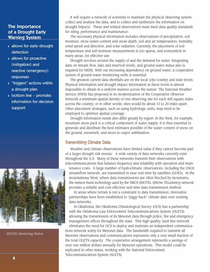
tenance costs. A large number of hydroclimatic observations, including the USGSstreamflow network, are transmitted in near real-time by satellites (GOES). In themountainous West, where data transmissions are often blocked by mountains,the meteor-burst technology used by the NRCS SNOTEL (SNOw TELemetry) networkprovides a reliable and cost-effective real-time data transmission method.
In areas where terrain is not a constraint to data transmission, innovative partnerships have been established to “piggy-back” climate data over existing data networks.
In Oklahoma, the Oklahoma Climatological Survey (OCS) has a partnershipwith the Oklahoma Law Enforcement Telecommunications System (OLETS)allowing the transmission of its Mesonet data through police, fire and emergencymanagement offices throughout the state. This high quality, land-line networkeliminates the need for OCS to deploy and maintain an independent communica-
tions network solely for Mesonet data. The bandwidth required to transmit allMesonet observations and communications represents only a very small fraction ofthe total OLETS capacity. The cooperative arrangement represents a savings ofover one million dollars annually for Mesonet operations. This model could bereplicated in other states, working with the National EnforcementTelecommunications System (NLETS).
4
The Importance of a Drought EarlyWarning System
◗ allows for early drought
detection
◗ allows for proactive
(mitigation) and
reactive (emergency)
responses
◗ “triggers” actions within
a drought plan
◗ bottom line – provides
information for decision
support
SNOTEL Monitoring Station

The Role of Remote SensingThe use of an individual type or
sources of data involves inherenttradeoffs and shortcomings, so datamust be integrated to enhance mean-ing and value. Complementary datafrom remote sensing, satellites, radar,aircraft and other technologies mustbe explored, encouraged and incorpo-rated to fill important data gaps.
Working with the Private SectorWhile governmental agencies
have shown great innovation in col-lection of drought data and development of new tools, an important role exists forthe private sector. Opportunities may exist in which government can set prioritiesand provide direction, and then allow for a competitive and innovative private sectorto meet the needs. During the course of public-private interaction, the NIDISLeadership Team will need to be sensitive to such issues as proprietary information,quality control of data, consistent methodologies, and standardization of the data.
Building a Baseline of Social, Environmental and Economic ObservationsNo systematic collection and analysis of social, environmental and economic
data focused on the impacts of drought within the United States exists today.Examples of data that could be collected include drought-related relief payments;mental health visits in drought-stricken areas; losses of revenue due to low water,ranging from river rafting guide revenues to barge tonnage; reduced hydropowerproduction; increased ground water pumping costs for agriculture and municipalpurposes; revenues from fish camp and canoe outposts; golf course revenue; agricultural yield losses not eligible for relief payments (e.g., nurseries); skier daysand snow-related tourism revenue; and ecological impacts data such as water quality, and impacts from wildland fires; etc. Because such data either are not centralized or not collected, officials often underestimate economic and social costsrelated to drought.
NIDIS should fill that gap by developing methodologies to collect and assess thesocial, environmental and economic impacts of drought across the United States.
These methodologies also should develop assess-ments from sectors not always at the forefront, suchas the livestock, timber, wildlife, energy, recreationand tourism sectors.
Understanding these impacts of drought willempower users and expand the comprehension of thefull magnitude of drought losses. By so doing, it willencourage local, state and federal officials to increaseefforts in drought planning, preparation, and mitigation.Comprehensive baseline data on drought impacts alsowill help to verify the relative cost effectiveness of“risk” versus “crisis-management” approaches todrought management.
5
No systematic collec-tion and analysis of
social, environmental and economic data focusedon the impacts of droughtwithin the United Statesexists today.... Becausesuch data either are notcentralized or not collected, officials oftenunderestimate economicand social costs related to drought.
Photo left: Lake Mead - photocourtesy of Dr. Ken Dewey, HighPlains Regional Climate Center

Developing New ToolsCurrent Tools and Needs
Current efforts at drought management are scattered throughout numerous federal, state, regional and local agencies. The Department of Agriculture’s (USDA)Natural Resources Conservation Service (NRCS) manages snow pack information,the Army Corps of Engineers (COE) and Bureau of Reclamation (BOR) managereservoir storage data, NOAA manages hydroclimatic data, Interior’s GeologicalSurvey (USGS) has ground water and stream flow information, and the EnvironmentalProtection Agency (EPA) manages various water quality programs in concert withthe states and tribes. Regional and state entities also provide considerable data andinformation services used for drought analysis in real time. These programs havegenerally evolved independently, require separate appropriations and, until recently,have not been available to users at a central location due to their complexity andthe absence of tools to accomplish data integration.
NIDIS will bring together a variety of observations, analysis techniques and fore-casting methods in an integrated system that will support drought assessment anddecision-making at the lowest geopolitical level possible. The tools will allow usersto access, transform and display basic data and forecasts across a range of spatialand temporal scales most suited to their individual needs. There are four basic typesof drought information tools:
1. Data access tools facilitate the retrieval of data from the different agencies thatcollect and archive it.
2. Analysis tools add value to the raw data through computer data transformation,modeling and statistical analysis.
3. Data display tools enable visual display of raw and analyzed data in ways toenhance its value to users. Geographic Information System (GIS) softwareenables the examination of geo-referenced information.
4. Forecast tools are a specialized analysis combining statistical properties of avail-able observations and models of future developments to make forecasts.
Future ToolsAn infrastructure to develop, integrate and maintain a suite of drought decision
support and simulation tools is fundamental for the success of NIDIS. It will be builton existing institutions with complementary expertise at local, state, regional andnational levels.
6
NIDIS will bring together a variety of observations,analysis techniques andforecasting methods in anintegrated system that willsupport drought assess-ment and decision-makingat the lowest geopoliticallevel possible.
May 18, 1999 May 23, 2000 May 22, 2001
U.S. Drought Monitormaps on these pagesshow the intensity ofdrought for mid May overthe past six years. TheMonitor is a joint effortby the USDA, NationalDrought Mitigation Center,Climate Prediction Center(NOAA), and NationalClimate Data Center(NOAA)

7
The NIDIS infrastructure will be developed in stages, and is dependent on adequate and sustained funding. Some drought tools focused on environmentalvariables (e.g., precipitation and temperature) are currently available but not integrated with user needs to comprise a complete product suite. Drought impactassessment tools and databases do not exist and will need to be developed.
Benefits of New ToolsThe Internet will allow quick, convenient, frequent, and low-cost assessments of
drought risk by users. Access to immediate drought information will be of continuingbenefit, since drought impacts vary by time of year. On-demand risk analysis willprovide the lead time needed to implement appropriate economic strategies toreduce drought impacts.
Coordinating Research and ScienceDrought-related research is critical in the production of innovations and technol-
ogy that lead to improved drought preparedness. Currently a coordinated and inte-grated drought research program does not exist at the national level, despite theenormous impact of droughts every year on the nation's economy, society and theenvironment. This fact sets drought apart from other major natural disasters, whichhave sustained federal research programs and significant interagency coordination.One example is the continuing research on hurricanes or severe storms and theirimpact. Currently, drought research is scattered across many agencies, universities,and other research institutions, without formal coordination or planning to maxi-mize the value of the research dollars spent and without effort to ensure that thepriority needs of the public and decision-makers are being addressed. The simpleact of coordinating drought research within and between levels of government, aswell as with private entities and universities, will help accelerate the developmentand provision of scientifically-based information products, thereby, enabling usersto better prepare for, manage and respond to the impacts of drought.
The most effective drought research efforts must include sustained interactionsbetween the research community and the customers of the information, such asdecision-makers, agriculture producers, water users, and other future NIDIS users.This collaboration would ensure that research stays focused on the highest priorityneeds for drought information.
May 14, 2002 May 20, 2003 May 11, 2004
IntensityD0 Abnormally Dry
D1 Drought - Moderate
D2 Drought - Severe
D3 Drought - Extreme
D4 Drought - Exceptional

Significant research efforts should focus on the development of improveddrought monitoring and forecasting at the regional and local levels where decisionsare made. Research to better understand drought decision processes and the oppor-tunities for the use of drought information in new applications also should beundertaken. Every improvement in the ability to predict drought frequency, durationand severity will result in increased effectiveness in planning and preparation tominimize its impacts, including planning for new or expanded water storage facilities.The drought indices and program triggers should be subject to refinement and revision in response to the needs of decision-makers and to advances in scientificunderstanding.
Drought tools and products must always be presented in a way that highlightsthe inherent uncertainties they contain. The value of coupling physically baseddrought models to impact or adaptive management models also should be investi-gated. Better documentation of all parameters of past droughts can improve history’susefulness in developing plausible "If, then..." scenarios. Parameters include therelationships among the extent, severity and longevity of droughts on humans andthe environment, plus impacts.
Information Dissemination and FeedbackMany people are aware of the need for water conservation and other measures
during drought. But once drought is over, old habits tend to dominate. The benefitsof sustained public awareness will be realized through NIDIS.
NIDIS will allow active user interaction in identifying and resolving problemswith the use of scientific information. Documentation and outreach is essential toinform the user community while also building confidence in the system’s integrity.User feedback on system functionality and ease of use will be an essential part ofan adaptive management approach to system maintenance and improvement.
The drought monitoring and prediction information produced by federal andnonfederal partners currently poses a problem for many users. The information isoften technical, complex and typically is not presented in a standardized format.Many potential users do not even know some drought resources exist. NIDIS willprovide drought information through the Internet in an interactive environment.NIDIS on the Internet also will provide access to related research that is not alwaysdisseminated in a timely way or through easily accessible modes. Opportunitiesshould be utilized to integrate NIDIS with existing systems (e.g., state flood warningsystems) used by decision-makers responding to other natural disasters.
Gaining and keeping the trust and confidence of users is essential for the proposedsystem to have credibility and long-term support. Achieving this goal will require a
continual focus on education, outreach,product development, verificationand refinement. Panels for initial test-ing of the system should be createdthat include users representing awide range of education levels andsectors of the economy, as well asfederal, state and local governmententities. Their input will help guidefine-tuning of the system.
8
The most effectivedrought research
efforts must include sustained interactionsbetween the researchcommunity and the customers of the information, such asdecision-makers, agriculture producers,water users, and otherfuture NIDIS users.
The cross-section is from a ponderosa pine stump, collected atSheep Pen Canyon in far southeastColorado, between Trinidad andSpringfield. The pith (innermost)ring is AD 1514, and the outermostring is 1768. All of the bark andsapwood have eroded away, indicat-ing that the death of the treeoccurred >100 years after the outerdate, so in the late 1800s or early1900s, which is consistent with thetree being cut by an early settler ofthe area. The trees at this site arevery drought-sensitive, and the sitering-width chronology that includesthis cross-section was used toreconstruct summer PDSI (PalmerDrought Severity Index) in easternColorado from 1550 to 1995.
Image courtesy of Jeff Lukas,INSTAAR DendrochronologyLab,University of Colorado.

9
RecommendationsThrough implementation of the recommendations below, we believe the goals
for a National Integrated Drought Information System will be achieved. If so, wecan successfully establish a dynamic and accessible drought information system toprovide users with the decision-support tools needed in preparing for and mitigatingthe impacts of drought.
The recommendations outlined in this report will require the commitment of essential personnel, funding and cooperation for NIDIS to be successfully accomplished.
1. Establishing NIDIS: The successful launch of the NIDIS will require effectiveleadership to oversee the development, coordination and implementation of itsvarious components and programs.
Recommendation 1a: NIDIS should be formally established.
Recommendation 1b: The National Oceanic and AtmosphericAdministration (NOAA) should be the lead federal agency for coordinatingimplementation of NIDIS.
Recommendation 1c: In anticipation of Congressional authorization ofNIDIS, NOAA should immediately establish a broad-based ImplementationTeam to carry out those aspects of NIDIS that can be accomplished throughexisting authorities and resources.
Recommendation 1d: The drought infrastructure at the federal level shouldnot be centralized in Washington, D.C. States and regional groups should beallowed to play a key role in the successful design and implementation ofNIDIS, and should have a designated and adequately supported, drought contact. These contacts should be identified and incorporated in the NIDISdevelopment process, and should be provided the resources necessary forinformation exchange, research, and tool development that is regionally orlocally specific.
2. Data Needs and Integration Tools: In order to make informed decisions,water users and resource managers need credible and readily accessibledrought information describing current and forecasted drought conditions and impacts.
Recommendation 2a: The NIDIS framework must integrate data from thewide variety of existing networks, and determine related gaps, both spatiallyand temporally. The networks should be stable, modernized and expanded toprovide the hydroclimatic data needed to assess drought risk. These dataneed to be real-time, be of appropriately fine focus to serve local areas, andhave sufficient long-term continuity and quality assurance to meet NIDISrequirements.
1. NOAA’s multi-use National Mesonet, made up of a modernizedCooperative Observer Network at its core, should be created and integrated with other federal and nonfederal networks.
“We must be vigilant andprepare ourselves forquick action when thenext drought cycle begins.Better planning on ourpart could limit some of the damage felt bydrought. I propose thatthis bill is the exact toolneeded for facilitatingbetter planning.”Sen. Pete Domenici, New Mexico, upon introducing The NationalDrought Preparedness Actof 2003

2. Additional federal and nonfederal networks also are vital to the successof NIDIS. These include those operated by NASA, EPA, USGS,USDA/NRCS, USDA/Forest Service, DOI's Bureau of LandManagement, Bureau of Reclamation, state and regional mesonets,state flood warning systems, etc. The necessary resources to maintainand strengthen their monitoring capabilities and integrate them withNIDIS are critical.
3. Using the Oklahoma Mesonet as a model, the NIDIS Leadership Teamshould explore partnership opportunities with the National LawEnforcement Telecommunications System (NLETS) and the variousstate law enforcement telecommunication systems in each state totransmit real time weather and climate monitoring data
Recommendation 2b: The NIDIS Leadership Team should identify and evaluate current and historical data sources on climate, water supply andstorage capabilities, and drought indices for their utility and applicability.NIDIS will be built on the integration of these existing databases, and expandedto fill information gaps. Tools and programs to fill the current gaps in droughtmonitoring may include the following:
1. Integrating meteorological, climatological, hydrological and agricultural/vegetation drought assessment tools within the NIDIS infrastructure,thereby deriving useful information beyond that contained in the separately maintained databases.
2. Developing new drought assessment tools that provide access to environmental data and analyses at the appropriate scale (e.g., state,watershed, county) in a GIS modeling framework.
3. Creating new water resources assessment tools to improve the under-standing of hydrological drought.
4. Producing tools capable of generating credible short- and long-termdrought forecasts in forms specific to user needs and locations.
5. Assembling tools to assimilate both remotely sensed (e.g., satellite,radar) and in situ instrument-based observations, with emphasis ontechniques to analyze and model the status of drought by integratingboth types of observations.
6. Having the National Drought Mitigation Center, at the University ofNebraska in Lincoln, be a principal clearinghouse for tools designed toaddress the needs of the drought community.
Recommendation 2c: NIDIS must provide a methodology to accurately andcomprehensively quantify the reporting of drought impacts across all relevantsectors and scales, through the following actions:
1. Developing a Web-based reporting system to collect quantitative andqualitative drought impact information for all sectors into a nationaldatabase within an interactive GIS modeling framework.
10
Lake Moultrie in South Carolinain September .

2. Developing tools capable of integrating drought impacts and environ-mental data into forms useful for mitigation and adaptive management.
3. Having the NIDIS Implementation Team identify opportunities to useexisting agency collection programs to gather additional data relevantto drought impacts. For example, the USDA's National AgriculturalStatistical Service (NASS) annual acreage and production survey couldbe modified to request information on crops, acreages and livestocknumbers affected by drought. NASS also could be used to establishimpact reports for other drought issues, (i.e., economic and social) as needed.
3. Research Needs. Agricultural producers, resource managers, municipalities,industries and other water users are obliged to make risk management andinvestment decisions that rely on current and anticipated climatic conditions.Research is needed to improve the forecasting of short- and long-term droughtconditions, to make the forecasts more useful and timely, and to establish priorities based on the potential to reduce drought impacts.
Recommendation 3a: NIDIS must facilitate the coordination and programdelivery across interagency, intergovernmental and private sector science and research programs by establishing an integrated federal drought research program:
1. Improving capabilities to monitor, understand and forecast droughts.
2. Developing methodologies to integrate data on climate, hydrology,water available in storage, and socioeconomic and ecosystem conditions,in order to better understand and quantify the linkages between thephysical characteristics of drought, the impacts that result fromdroughts, and the triggers used by decision-makers who respond todrought.
3. Identifying regional differences in drought impacts and related infor-mation needs and delivery systems, and developing regionally specificdrought monitoring and forecasts.
4. Developing new decision support tools, such as drought "scenarios"(e.g., "if, then."), that would give decision-makers (such as agriculturalproducers) a better range of risks and options to consider.
5. Improving the scientific basis for understanding ground water and surface water relationships and developing triggers and thresholds forcritical surface water flows and ground water levels.
6. Encouraging all relevant federal agencies, in cooperation with theNIDIS Implementation Team, to expand their drought research portfoliosby undertaking an analysis of existing research and identifying gaps.The findings of this gap analysis should guide funding and priorities forfuture drought research.
7. The federal agencies participating in the coordinated research programunder NIDIS should commit a percentage (no less than five percent) oftheir research budgets to drought issues.
11
Joshua Tree National Park,Arizona, in 2003. Photo courtesyof Kelly Redmond of the WesternRegional Climate Center.
Cornfield affected by drought and grasshoppers (2002 National DroughtMitigation Center)

4. Facilitating Drought Preparedness Programs. NIDIS will provide a sound,scientific basis on which to develop effective drought mitigation and responseplans, by describing the nature and magnitude of the historical drought threatand providing information on the likelihood and severity of drought.Additionally, federal drought programs need better coordinated triggers to facilitate timely assistance to areas where drought is emerging.
Recommendation 4a: NIDIS should facilitate drought planning by providinginformation to aid in development of science-based triggers in preparednessplans that will result in timely actions to minimize impacts and reduce risks.The National Drought Mitigation Center, which has established expertise,should help in this effort.
Recommendation 4b: The NIDIS Leadership Team should work in partnershipwith federal agencies responsible for drought assistance programs to analyzeprogram triggers and make recommendations for improving program delivery.
5. Interaction and Education: Building on existing programs, NIDIS must providea framework for education of water users, resource managers and the public,and for interaction among users of the system.
Recommendation 5a: To address the information needs of the various usersof the NIDIS and assure continuing feedback from them on how to improve itsdesign, NOAA, private entities, and the NIDIS Implementation Team shouldperform ongoing evaluation of the usefulness, usability and timeliness ofNIDIS products. To accomplish this task, NIDIS should create user panels totest initial phases of the system and to conduct ongoing qualityassurance/quality control assessment.
Recommendation 5b: NIDIS should support drought outreach efforts by providing guidance and assistance to education programs and outreach trainingon ways to plan for, mitigate, anticipate and respond to droughts.
12
Almost empty Platte River nearMahoney State Park(9/3/03). Photo courtesy of Ken Dewey of the High PlainsRegional Climate Center
This foundation rests about ahalf-mile southeast of the maintownsite. This is in the lake bed,about 100 yards from the lake'seastern dike, which comes intoview about halfway up the rightside of this photo. The establish-ment of many grasses indicatesthat this area has been exposedfor quite a while.© 2004 Derek S. Arndt. All Rights Reserved.

13
Western Governors’ AssociationNational Integrated Drought Information System (NIDIS)
AcknowledgementsThe Governors thank the many people who contributed to the development of
this important and timely report.
Core TeamDon Artley, National Association of State ForestersSusan Avery, Director of CIRES, University of
Colorado, BoulderMark D. Brusberg, USDA/OCE/WAOBKen Crawford, Oklahoma Climatological SurveyTim Darden, New Mexico Department of
AgricultureRandall Dole,NOAA-CIRES Climate Diagnostics
CenterRainer Dombrowsky, Observing SystemsDave Easterling, NOAA-NCDCJohn O. Erickson, Governor’s Policy Research
Office, NebraskaMichael Hayes, National Drought Mitigation CenterBill Hume, Office of the Governor, New MexicoDouglas Le Comte, NOAA/Climate Prediction
CenterLilas Lindell, Bureau of ReclamationHarry F. Lins, U.S. Geological SurveyRobert Livezey, National Weather ServiceRichard Moy, Montana Dept. of Natural Resources
& ConservationFrank F. Navarrete, Office of the Governor,
ArizonaJ. Rolf Olsen, U.S. Army Corps of EngineersPhil Pasteris, USDA-NRCSSteven Pritchett, National Weather Service
Observing Services DivisionRoger S. Pulwarty, University of Colorado -
Climate Diagnostics CenterKelly Redmond, Deputy Director / Regional
ClimatologistLawrence M. Riley, Arizona Game & Fish
Dept./IAFWADavid A. Robinson, NJ State Climatologist/AASCJack Stults, Montana Water Resources DivisionMark Svoboda, National Drought Mitigation Center
Brad Udall, Western Water AssessmentAnne Watkins, Office of the State EngineerRobert S. Webb, NOAA-OAR CDCDon Wilhite, National Drought Mitigation Center
Interdisciplinary Team and OthersJesse Aber, Montana Governors Drought Advisory
CommitteeDeke Arndt, Oklahoma Climatological SurveyStephen Belbin, Kutztown University, PennsylvaniaMichael Brewer, National Weather ServiceJesslyn F. Brown, SAIC, USGS/EROS Data CenterTom Carroll, National Weather ServiceDaniel Chan, Georgia Forestry CommissionJan Curtis, Wyoming State ClimatologistJohn R. D’Antonio, Jr. P.E., New Mexico State
EngineerAllen Dedrick, USDA–Agricultural Research
ServiceJared Entin, NASABrian Fuchs, High Plains Regional Climate Center
Neal Fujii, Hawaii State Drought CoordinatorGregg Garfin, Climas/University of ArizonaSusan Gilson, Interstate Council on Water PolicyTom Gordon, Toole County CommissionerRichard R. Heim Jr., NOAA/National Climatic Data
CenterSteven Hilberg, Midwest Regional Climate CenterBob Hirsch, U.S. Geological SurveyHeath Hockenberry, National Interagency Fire
CenterRebecca Inman, WA Dept. of EcologyTom Iseman, The Nature ConservancyJay Jensen, Western Forestry Leadership CoalitionJeanine Jones, California Division of Water
ResourcesJohn M. Klein, U.S. Geological SurveyFelix Kogan, NOAA/NESISDouglas R. Kluck, National Weather Service Central
Region HQCharlie Liles, National Weather ServiceThomas Loomis, Arizona Floodplain Management
AssociationStewart Lovell, State of DelewareTom Lowe, Kansas Water OfficeSue Lowry, Wyoming State Engineer’s OfficeBrad Lundahl, Colorado Water Conservation BoardDawn Matson, Office of the State Engineer, New
MexicoDoug McChesney, WA Dept. of EcologyGreg McCurdy, Western Regional Climate CenterDan Murray, PE, USDA-NRCSDean A. Nakano, Hawaii Commission on Water
Resource ManagementWilson W. Orr, NASA Program/Blueline GroupMichael A. Palecki, Midwestern Regional Climate
CenterNancy Parker, U.S. Bureau of ReclamationAl Peterlin, ERREx, PennsylvanniaScott Rayder, NOAAFrank Richards, National Weather ServiceTed Sammis, New Mexico State CliatologistMark Shafer, Oklahoma Climatological SurveyLois Sorensen, State of FloridaTom Spencer, Texas Forest ServiceKurt Suchsland, State of NevadaMark Weltz, USDA–Agricultural Research ServiceGene Whitney, Ph.D., Office of Science and
Technology PolicyTony Willardson, Western States Water CouncilConnie Woodhouse, Paleoclimatology Program,
National Climatic Data CenterKlaus Wolter, NOAA-CIRES Climate Diagnostics
CenterGregory A. Zielinski, University of Maine Climate
Change Institute
StaffShaun McGrath, Western Governors’ AssociationBruce Flinn, Coyote Consulting, L.L.C.

1515 Cleveland Place • Suite 200 • Denver, CO 80202303-623-9378 • www.westgov.org