Embed Size (px)
DESCRIPTION
Â
Citation preview

����������� �
��������������

����� ������������������������ ��� ��������
������� � ��� ���������������������� ��� ������ !�"#�� �$#������%&���'() *(+�
����,������������������������
����� ���������������������������� ������
������ ��� ���������������������!������������!�������
"� �#������ ����$��%�������&��������'()�*(������ ����'��������+�)�������,
-�.��� /�&����������������������
�������� ���������� �����������0�')�#'1������#� ����
#����������� -,
.�����������-����������/���� ���/������0�� ���� ������ �#����-��������� �+"��#����+��(/1���������������� ���������������������23�����4�3������5����������6���������$#�� � - ��� --����1#��� ���1%� �7������0������8�������9�����-���.���� �� ������� � �����������:1���-� ����6��������� --����1;����< �0 ���������������
Date declared a Nature Reserve: 13th April 1987Date of approval of PORN:(Plan for Administration of Natural Resources)16th July 2004
In l'Alcoià county, between the municipal boundariesof Alcoy and Ibi, you will find the ‘Parc Natural de laFont Roja’, one of the best preserved nature areas inValencian territory. The nature reserve sandal some2.298 have, and he/she understands the mountai-nous alignment of l'alt of Sant Antoni, the carrascal ofRed Font and Teixereta. The summit of Menejador,with 1.356 m of height is the highest bench mark inthe reserve.
The range, part of the Bético system, has a positionand geological history proper to this chain of moun-tains. The massif consists basically of lime rocks fromthe Tertiary geological era. The ‘Cova Gelada’, veryclose to the ‘Font Roja’ sanctuary, vouches for theexistence of the karstification processes commonlyassociated with this type of rock.
A series of cliffs and rubble zones has developedunder the crest of the Menejador. The stony out-crops and the finer materials, that come from collap-sing cliffs and other limestone rocks, represent thematerials of the Quaternary. Keuper's marls are themost ancient materials in the park (Triassic period ofthe secondary age), and come to the surface at theroad for access to the ‘Font Roja’ sanctuary and theTetuán path.
J. L.
Alb
ors
J. L.
Alb
ors
It is also one of the last nesting redoubts in the southerncounties of Valencia of such ornithological species as theeurasian sparrowhawk (Accipiter nisus) or the northerngoshawk (Accipiter gentilis), amongst others.
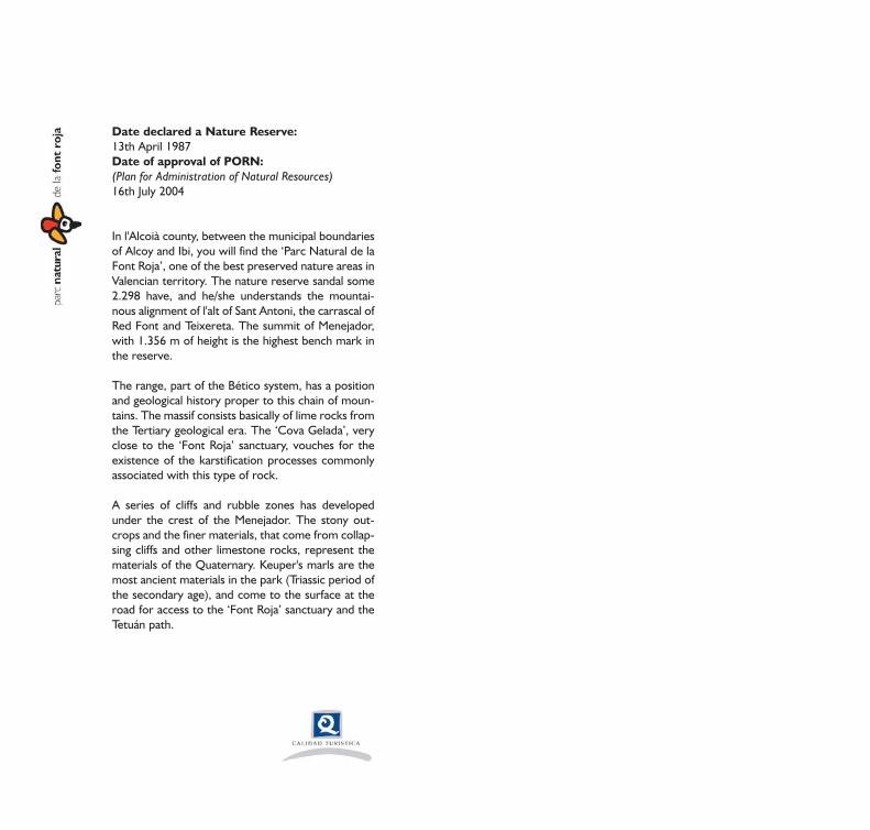
Of all the species of fauna inhabiting the Reserve, thereare a few prominent ones through their scarcity orrarity such as Bonelli's eagle (Hieraaetus fasciatus), stonemarten (Martes foina) and the eagle owl (Bubo bubo). Inthe invertebrate fauna the presence of the Euphydryasdesfontanii butterfly is relevant for its rarity.
The sunny area is the domain of different species ofreptiles such as the lacertid lizard (Psammodromus algi-rus), Lataste's viper (Vipera latastei), the ladder snake(Elaphe scalaris), southern smooth snake (Coronellagirondica) and the ocellated lizard (Lacerta lepida)
Eagle owl (Bubo bubo)
Fauna
The existence of a well-preserved wood and diffe-rent landscape areas in the park, such as the longcliffs, stony outcrops, pines and farmland, all favourthe presence of rich and varied fauna.
Associated with wood formations there are speciessuch as the robin (Erithacus rubecula) and firecrest(Regulus ignicapillus), common Chaffinch (Fringillacoelebs), great tit (Parus major), short-toed treecree-per (Certhia brachydactyla), jay (Garrulus glandarius)and the tawny owl (Strix aluco).
As regards mammals, its large numbers make theboar (Sus scrofa) an important part of the fauna. Alsofound are the genet (Genetta genetta), the weasel(Mustela nivalis), the wildcat (Felis sylvestris) or thebadger (Meles meles).
Wildcat (Felis sylvestris)

J. A
cost
a
sis), the whitebeam (Sorbus aria), the yew (Taxus bacca-ta), etc.. The biogenetic interest of the plants formingthis wood and its nature as a relic in the Valencian areagive this high ecological value. The seasonal change dueto the deciduous and marcescent nature of many of thedominant plants make this countryside an area of greatbeauty through its wide chromatic range.
Shady evergreen oak groves. From 600 to 1,250metres in altitude there is a wood of evergreen oaks(Quercus ilex ssp. rotundifolia), enriched with deciduousplants such as the ash or the maple, and marcescenttrees such as the gall oak in the cooler and shadierzones. The evergreen oak undergrowth is plentiful, withmany different species such as ivy (Hedera helix), honey-suckle (Lonicera implexa and L. etrusca), wild madder(Rubia peregrina), spring snowflake (Viburnum tinus) orthe hawthorn (Crataegus monogyna).
Sunny zone brushwood. The greater amount of sun-light and dry nature of the southern face allow thesebushes with some scattered evergreen oaks to grow.The species that commonly appear in this unit are thesister cushion (Erinacea anthyllis) from 900 metres inaltitude, types of gorse (Ulex parviflorus and Genistascorpius), rockroses (Cistus sp.), junipers (Juniperus oxy-cedrus), aromatic and medicinal plants such as thyme(Thymus vulgaris), pebrella (Thymus piperella), theMariola sage (Salvia blancoana ssp. mariolensis), spikelavender (Lavandula latifolia), rosemary (Rosmarinusofficinalis) and all sorts of gramineae which differentia-te the sunny zone from shadier parts, such as Stipatenacissima.
Rock vegetation. On the slopes, extended cliffs andgashes in the rock common on the shady side of theMenejador there are plants adapted to growth inscanty soil conditions, such as the Jasione foliosa,Potentilla caulescens, etc.. Their root-taking strategiesenable them to settle in cracks in which there is only atiny amount of soil.
Vegetation
The way the mountain range stretches from northeastto southwest means that the cold damp winds fromthe northeast prevalent in the reserve are prone to beheld up at the north face and leads to rain there. Thevegetation also facilitates the condensation of mist,producing the crypto-precipitation that increases theamount of water supplied to the ground.
This fact, along with the relief, which is a lot steeperand rougher on the north face, and the dominance oflimestone materials in the lithological composition,have led to the presence of different plant landscapesystems:
Deciduous woods. In the darker and shadier cornersof the northern side and at altitudes over 1,250metres, there are woods of deciduous trees consistingof the gall oak (Quercus faginea ssp. valentina), the ash(Fraxinus ornus), the maple (Acer opalus ssp. granaten-
Chromatic variety of the vegetation of the parcin the spring time

J. L.
Alb
ors
J. L.
Alb
ors
455 different species of fungi have been found, seekingtheir nourishment in different ways, either saprophytic,parasitic or symbiotic. In a normal year fructificationstarts in October and ends in January-February.
Lichens, symbiotic associations between fungi and algae,colonise areas where other plants find it hard to grow.These are organisms of great ecological value, providingfood and shelter for many animal species, securingatmospheric nitrogen and acting as effective bioindica-tors of atmospheric contamination. There is a widerange of these organisms to be found in the Reserve.
One should stress the presence of certain endemisms.A plant endemism is a species whose worldwide distri-bution is very restricted. In the ‘Parc Natural de la FontRoja’ there are some exclusive endemisms such as Sal-via blancoana ssp mariolensis and others with a verylimited distribution area such as the "carraspique" (Ibe-ris carnosa ssp hegelmaieri), "Valencian pea" (Lathyrustremolsianus), rock plant Saxifraga corsica ssp cossonia-na and "pebrella" (Thymus piperella).
Valencian pea (Lathyrus tremolsianus)
Rubble vegetation. On the slopes covered withloose stones, at the base of the sheer drops, there areplants adapted to life in a highly unstable medium, suchas the service-berry (Amelanchier ovalis), the ash, themaple and the whitebeam.
Pine woods. On the lower levels of the mountainrange, in the zones where charcoal production andevergreen oak felling have been intense, the evergre-en oak groves have suffered greatly. The Aleppo pine(Pinus halepensis) woods are to a large extent theresult of repopulation introduced in former evergre-en oak zones.
Crops. The surface area used for crops is of scantyrelevance due to the rather unfavourable weather andgeographical conditions. The crops found are unirriga-ted land varieties (cereals, fruit and olive trees).
The weather conditions prevalent here lead to a plen-tiful variety of mycological and cryptogamic flora, fungi,lichens and mosses.
Evergreen oaks (Quercus ilex)

B. A
lbia
ch G
alán
of the estate, run by a single family is the mas; a buil-ding which played the role of house, stable and farm-yard. These farmsteads represented the commonestway of life and agro-forestry work in the Spanishpeninsula's Levante region.
Special mention should be given to the six ‘cavas’, orsnow pits, large deep holes reinforced with masonrywalls and roofs, which from the 17th to the early20th centuries, were used as supplies of ice forneighbouring towns and villages as a gastronomic ormedical commodity. In the 18th century the snowtrade played an important role in the mountain coun-ties, propitiating the birth of the ice-cream industryin places like Jijona.
Pou de Neu del Canyo
History
At the ‘Font Roja’ the traces of the work done by mantaking advantage of the natural resources availablehere can still be seen.
The production of charcoal from dry branches of ever-green oak was done by building charcoal kilns, whichhave left blackened circles with no plant life still visiblebeside the paths.
In some areas of the park there are still remains ofancient lime ovens - cylindrical structures where thelimestone was transformed through heat into lime,which was used in building and as a disinfectant.
The farmland was used in estates scattered over thereserve, most of them on the skirts of the mountain-side, taking advantage of the less steep slopes and see-king areas that were favourable for farming. The heart
1
2
3
4
51
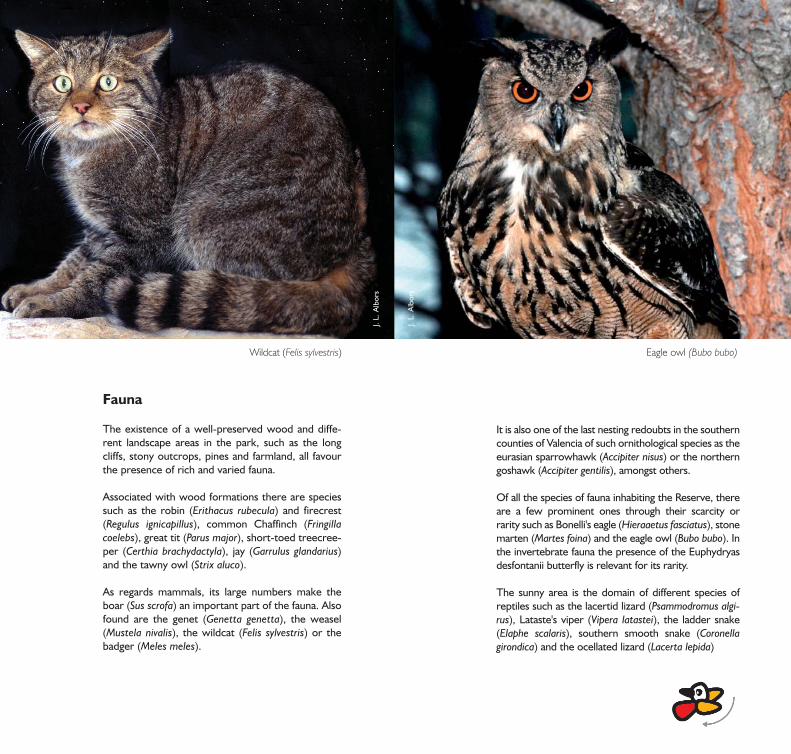
‘Pla de la Mina’A little later you come to the ‘Pla de la Mina’, wherethere is a reproduction of a lime oven and two vantagepoints over this. Here you can appreciate the reddishcolour of the clays that come out to the surface amongthe calcareous rock of which these mountains are made.
‘Pla dels Galers’At 1.1 Km from the start you reach the ‘Pla delsGalers’, where it is easy to find boar (Sus scrofa) tracksin the mud and even mudbaths where they wallow. Inthis tract of the itinerary, the carrascar forms a densecovered with vegetation in the one that different spe-cies of mosses, líquenes and climbings are plentiful,favored by an environmental bigger humidity and anappreciable descent of the temperature.
Pilatos vantage pointAbout 900m further on, on the right you will find thePilatos vantage point, from which there is a splendidview of the ‘‘Parc Natural de la Serra Mariola’ moun-tain range and the valley of the river Polop. Lookingback across the north side of the ‘Carrascal de la FontRoja’ you can see in the higher zones the profuse deci-duous trees which, combined with the holm oaks,form the mixed Mediterranean wood.
‘Mas de Tetuán’2.6 Km from the beginning we reach the ‘Mas deTetuan’, an example of traditional farming techniques,built in the late 19th century. Beside the threshingfloor you will find an ancient specimen of the teak(Taxus baccata), a species of which very few speci-mens remain in the Park.
‘Menejador’ itinerary
This roughly 6 km itinerary is the Park's main route,and tends to take about 2,30 hours.
The first half of the route goes along the north side of themountain range, where you can see the shady holm oakgroves characterised by the plentiful ilex or holm oaks(Quercus ilex) with some specimens of the maple (Aceropalus ssp. granatense), ash (Fraxinus ornus) and gall oakor Valencian oak (Quercus faginea ssp. valentinae).
’Cova Gelada’Starting from the Visitors' Centre, located at an altitu-de of 1,050m, you will soon come to the ‘Glorieta delsPaellers’, where the most ancient holm oaks in thePark are found. 20 m away on the left-hand side youwill see the ‘Cova Gelada’, characterised by its cool-ness (7ºC).

CV-795
CV-801
CV-796
CV-785
CV-70
CV-
794
A-36
N-3
40
N-340
AlcoiCastell de Barxell
mirador de Pilatos
Cava Coloma
Pou del Canyo
Pou de Simarro
Pou del Canonge
Área Recreativa deSant Antoni
Mas de Nyego
Ermita de Sant Pascualy área recreativa
Les Foies Blanques
Mas de Castelló
Mas de Foiaderes
Casa de Campos
Mas de Foladeretes
Mas de Canonge
Mas de Roc
Mas de Mató
Venta de Sant Rafel
pinturas rupestresde la Sarga
Urb. l’Estepar
Font del Mas de Felip
El SaltFont delMolinar
Font del Corbó
Font de la Devesa
Mas de Merente
Xirillen Vell
UrbanizaciónMontesol
el Pare SantetAlt del TroncalMas de la Borra
Ermita de Barxell
Ermita de Sant Antoni
Urb. el Baradello
El Castellar(yacimiento)
Via verdaRio Polop
Barranc de la batalla
Els Canalons
Mas de la Safranera
Racó de Santa Ana
el Racó de Pellisser
Mas de Bonavista
Cava de Sta. Maria Pou de Noguera
Mas del Baró
el Menejador
El Preventori
Ibi0 1.000500
E: 1/60.000
4.000 m2.000
road
path
‘Menejador’ itinerary
‘Barranc d l’infern’ itinerary
The short itinerary
constructions
administrative boundary
castle
fountain
information centre
geodesic vertex
peak
viewing point
hermitage
snow well
rest area
parking
cave

J. L.
Alb
ors
B. A
lbia
ch G
alán
6 7 ‘el Menejador’After reaching the water tank for fire extinguishingthere are still 500m to the top. The Menejador (point7), with its 1,352m, is one of the highest points in theprovince, which means that on clear days you can see asfar as the Island of Tabarca, or the table of Almansa,apart from the surrounding mountains: Mariola, Aitana,Cabeçó d'Or, Maigmó, Penya Roja...
When you go down along the forest track, at 50m fromthe water tank you will find the Carboneras path which,down fairly steep steps, takes you down the shady sideback to the ‘Pla de la Mina’. It is a very narrow path ofabout 900 m which makes the visitor feel really enclosedby the wood.
The path ends in the forest track, which you follow tothe right for ten minutes until coming to the Santuariosquare, where there is the popular ‘Font Roja’ spring.
Sight towards the north from the ‘Menejador’
‘cava Coloma’After a further 800m you reach the ‘Cava Coloma’, anicehouse built with a capacity of 2,200m3, one of themost ancient constructions used for keeping and sto-ring snow, obtained by collecting and pressing insidethe snow from the surroundings of the well.
Going along the forest track you reach the south orsunny side, appreciating the different vegetation in thiszone, where the holm oaks are seen scattered and stun-ted, with a predominance of aromatic plants like thyme(Thymus vulgaris), Gramineae such as esparto grass(Stipa tenacissima) and also scorpion broom (Genistascorpius), rock rose (Cistus sp.) and junipers (Juniperusoxicedrus). In this zone it is easy to see reptiles such asthe ladder snake (Elaphe scalaris) or the ocellated lizard(Lacerta lepida). From this point you can see a furtherthree icehouses: Noguera, Simarro and Caño.
Cava Coloma

1
2
3
In this area you can see the shady holm oak grove cha-racterised by the plentiful holm oaks (Quercus ilex) withsome specimens of the maple (Acer opalus ssp. granaten-se), ash (Fraxinus ornus) and gall oak or Valencian oak(Quercus faginea ssp. valentinae).‘Pla dels Galers’At 1.1 Km from the start you get to the ‘Pla dels Galers’, thehighest point on the route and where it is easy to find tracksof boars (Sus scrofa) in the mud and mudbaths where theywallow. From this point, looking towards the higher zones,you can view the mixed Mediterranean wood characterisedby the plentiful deciduous trees accompanying the holmoaks. By crossing the Pla to the right you find the path thatdrops towards the ‘Barranc de l'Infern’ ravine.
Amongst the most characteristic vegetation, you can seeclimbing species such as honeysuckle (Lonicera implexa and L.etrusca) and the wild madder (Rubia peregrina). In the sunnierzones there is also a plentiful presence of bushes such as thewild genista (Cytisus heterochrous), the escobón (Cytisusreverchonii) and the hawthorn (Crataegus monogyna).
This environment acts as the habitat for many animal spe-cies, amongst which you can see birds such as the spa-rrowhawk (Accipiter nisus), goshawks (Accipiter gentilis),robins (Erithacus rubecula), warblers (Sylvia sp.), nightin-gales (Luscinia megarhynchos)...
After a ten-minute descent there is a spectacular rockycliff, where the path takes a turn allowing a lovely view ofthe valley of the river Polop.
As you go on you will see a change in the type of vegeta-tion, going from the shady holm oak groves to a predo-minance of pine trees, which corresponds mainly torepopulations of Aleppo pine (Pinus halepensis) in zonespreviously occupied by holm oaks. The bush strata of thisecosystem is poorer as regards the quantity and variety ofspecies, with a predominance of scorpion broom (Genis-ta scorpius), rock rose (Cistus sp.) and some junipers (Juni-perus oxycedrus).
‘Barranc d l’infern’ itinerary
This roughly 4’5 km itinerary normally takes about1:45 hours, leading along the north side at altitudesfrom 950 to 1,190m.
‘Cova Gelada’The route starts at the Visitors' Centre, as far as a shortdistance from the ‘Glorieta dels Paellers’, where themost ancient holm oaks in the park are found. 20 maway you will see the Cova Gelada (point 1) on the left,characterised by its coolness (7ºC).
‘Pla de la Mina’A little later you reach the ‘Pla de la Mina’, where thereis a reproduction of a lime oven, and two vantagepoints with lovely views. In this zone you can appre-ciate the reddish colour of the clays that come out tothe surface among the calcareous rock of which thesemountains are made.
B. A
lbia
ch G
alán
4 4 The short itinerary
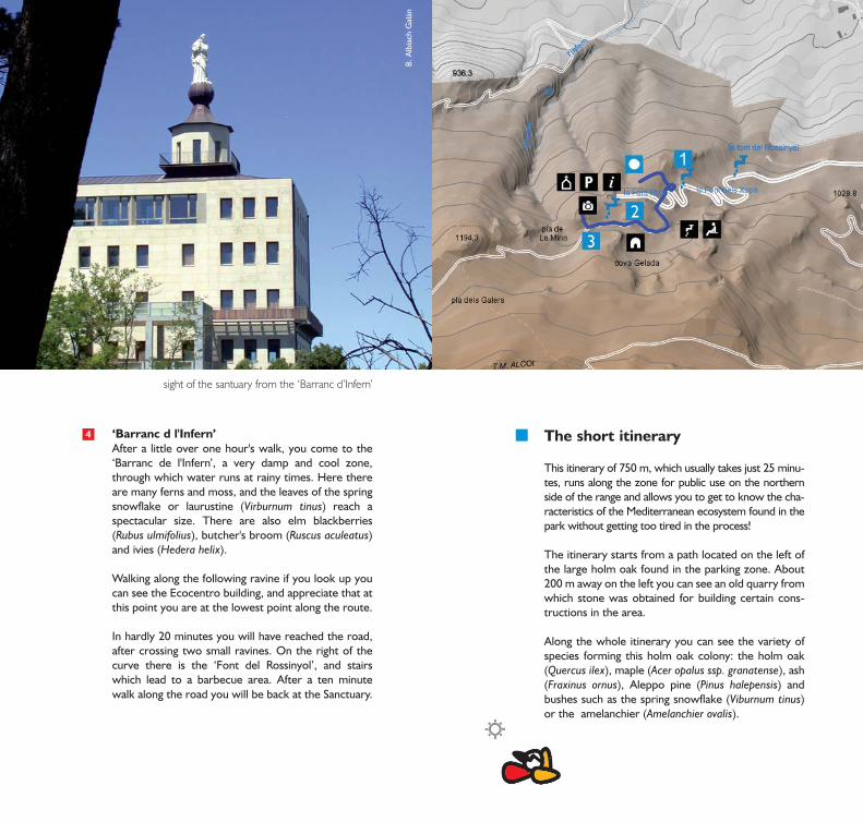
This itinerary of 750 m, which usually takes just 25 minu-tes, runs along the zone for public use on the northernside of the range and allows you to get to know the cha-racteristics of the Mediterranean ecosystem found in thepark without getting too tired in the process!
The itinerary starts from a path located on the left ofthe large holm oak found in the parking zone. About200 m away on the left you can see an old quarry fromwhich stone was obtained for building certain cons-tructions in the area.
Along the whole itinerary you can see the variety ofspecies forming this holm oak colony: the holm oak(Quercus ilex), maple (Acer opalus ssp. granatense), ash(Fraxinus ornus), Aleppo pine (Pinus halepensis) andbushes such as the spring snowflake (Viburnum tinus)or the amelanchier (Amelanchier ovalis).
‘Barranc d l'Infern’After a little over one hour's walk, you come to the‘Barranc de l'Infern’, a very damp and cool zone,through which water runs at rainy times. Here thereare many ferns and moss, and the leaves of the springsnowflake or laurustine (Virburnum tinus) reach aspectacular size. There are also elm blackberries(Rubus ulmifolius), butcher's broom (Ruscus aculeatus)and ivies (Hedera helix).
Walking along the following ravine if you look up youcan see the Ecocentro building, and appreciate that atthis point you are at the lowest point along the route.
In hardly 20 minutes you will have reached the road,after crossing two small ravines. On the right of thecurve there is the ‘Font del Rossinyol’, and stairswhich lead to a barbecue area. After a ten minutewalk along the road you will be back at the Sanctuary.
sight of the santuary from the ‘Barranc d’Infern’

B. A
lbia
ch G
alán
1
2
3
‘Cova Gelada’A little under 100 m away you come to the CovaGelada (point 2), a specimen of the Karstic modellingfound in mountains consisting of limestone. Anotherexample of structures resulting from erosion proces-ses affecting these rocks is the Penya L'Espinellawhich is on the left of the track a little further on andacts as a shelter for a maple with a bushy shape.
Along the track you will see an emergence of the cla-yey materials which give the earth a red colour andthe name to this spot.
‘Pla de la Mina’300m from the barbecue zone you will find the ‘Plade la Mina’, where it is easy to find boar (Sus scrofa)tracks in the mud and even mudbaths where theywallow. Here there is a reproduction of a lime oven,beside which there are stairs which lead towards twovantage points. The first gives a view of the valley ofAlcoi and the basin of the river Serpis on its waytowards Gandía. The second, which is accessed bystairs down, shows a beautiful panorama of the valleyof the river Polop and the southern side of the ‘‘ParcNatural de la Serra Mariola”.
From here we will take the same road, but crossingby the barbecue sites to go towards the municipal oldchalets which is located at about 500m.
Going down the stairs in front you come to the Sanc-tuary square, where there is the famous ‘Font Roja’,from which icy cold water gushes. Beside this thereare the hermitage and the building Red Font Nature(FRN) that houses the Center of Visitors of the park,provided with a vantage point which gives a specta-cular view of the ‘Barranc de l'Infern’. From here youcan see the car park where this itinerary ends.
‘Font dels Xops’Just 100 m further on you come to the ‘Font delsXops’ spring (point 1), where there are beautiful spe-cimens of the poplar (Populus alba), one of which isgrowing sideways along the ground. On these thereare ancient stocks of ivy (Hedera helix). Also in thiszone there are gall or Valencian oaks (Quercus fagineassp. valentinae) and in Spring the flowering of beardediris (Iris germanica) is spectacular.
By going up the stairs you come to the controlledcamping site, with room for 20 tents (informationand permits from Alcoi Council: 965537141). Otherstairs lead you to cross the road to reach the foresttrack which leads towards the ‘Glorieta dels Pae-llers’, very highly frequented by visitors as it haszones where fires can be lit if alert situation 3 is notdeclared.
Sight from the ’Pla de la Mina’
Accommodation
Apart from the hotels available in Alcoy and Ibi, thereare hostels and "casas rurales" (rural guesthouses)around the Reserve. The ‘Font Roja’ has a restrictedcamping zone, but permission must be applied forsome time in advance, at the young people's informa-tion centre at Alcoy Council(tel. 96 553 71 41).
Cuisine
Some typical dishes in the zone are: ‘bajoques farci-des’ (red peppers stuffed with rice), ‘la olleta demusic’ (bean stew), ‘pericana’ (dry peppers, cod andolive oil) and ‘borreta’ (spinach stew with cod andpoached egg) or ‘giraboix’ (meat and vegetable stewsimilar to cocido) very typical in Ibi. Alcoy sweets arefamous, peladilla sugared almonds and ‘pasteles degloria’ cakes, as well as its café-liquor, a stimulatingdrink consumed in large quantities at the Moors andChristians festivals.
How to get here
The Nature Reserve's Visitors' centre is 11 Km. fromAlcoy, taking the road leading to the ‘Font Roja’Sanctuary.
At the Alcoy exit heading towards Alicante on the N-340, road AP-2001 to ‘Font Roja’ starts (the turnoff issignposted).
It is recommended to begin the visit from the Centerof Visitors, paymaster in the building Font Red Natu-re, next to the Sanctuary. Where he/she will find avai-lable material audiovisual divulgativo, about the
Visits of interest
In the area of the ‘Font Roja’ Sanctuary there is a cha-pel dedicated to the Virgin of the Irises. The culturalevent which most definitely defines the ‘Parc Naturalde la Font Roja’ is the extraordinary occurrence on21st August 1653, when monk Antonio BonaventuraGuerau found the image of the Virgin Mary on thebulb of an iris. Ten years later the first chapel wasbuilt, successively reconstructed until taking its pre-sent form. This led to the area becoming a centre ofreligious interest, today remembered by the crowdsof people attending the procession held every sum-mer in honour of the Lady of the Irises.
In the nineteen-twenties a hotel was built beside theSanctuary which was successfully run for over 50years. The row of old municipal summer houses alsodates back to this time. In the nineteen-nineties thepresent Ecocentre was built on the base of the for-mer hotel, intended for displaying the natural andcultural aspects connected with the ‘Parc Natural dela Font Roja’.
- ‘La Sarga’ cave paintings. - Iberian settlements in the Puig and Serreta. - Saint Antoni Chapel.- Saint Pascual Hermitage. - Barxell Castle
- ‘Serra Mariola’ nature reserve (‘Barranc del Cint’ravine, ‘San Cristóbal’ beauty spot, ‘Font deMariola’ spring...)
- ‘Racó de Sant Bonaventura’ - ‘Els Canalons Munici-pal’ beauty spot.
- ‘La Serreta’- ‘Barranc dels Molins’ ravine

environmental and cultural values of the Park. Also, in thisbuilding he/she will also be able to receive the attentionof other two entities like CAM, in their Center of Envi-ronmental (CEMACAM) Education, and the Scientificdependent Station, of the University of Alicante.
The staff in charge at the Centre can give visitors sugges-tions about different routes around the Reserve, and theservices of a guide can be requested if he wants himself,for school centers and associations.
Walk without leaving any trail behind you
Leave the place cleaner than when you arrived,deposit your own rubbish and if possible any other wasteyou may find in the nearest bin.
Respect the path, go by the signs on the tracks, ot tak-ing short cuts, and you will be doing the ecosystem a greatfavour.
Fire is the greatest enemy of the mountains, do notlight bonfires nor smoke. Breathe in fresh air.
Look at the plants without destroying them, do notpull up plants or flowers - take notes or photos.
Observe animals without bothering them, hunting isforbidden in the whole nature reserve.
Use hotel and tourist facilities in nearby towns andvillages, as you cannot camp in the reserve.
Take care of the springs, as these are the most valuableasset of our mountains, and do not contaminate them.
Forget all about motor vehicles, and enjoy thesilence, noise is another form of pollution.
Respect our historical and cultural heritage, avoidany actions which may deteriorate the terraces orbuildings.
The dogs must go tied, can cause inconveniences(troubles) to the avifauna
If you do noise or speak fort, you will get lost the soundsof the forest
In the event of any emergency call 112.