Embed Size (px)
Citation preview
Arrowhead Regional Development Commission February 2006
Fond du Lac Trail Connections
Plan
February 2006
Adopted by the Fond du Lac Reservation Business Committee pursuant to Resolution #1203/06 on August 9, 2006


Fond du Lac Trail Connections Plan
-February 2006-
Prepared by:
Fond du Lac Planning Department
Facilitated by:
Arrowhead Regional Development Commission


Fond du Lac Trail Connections Plan
Table of Contents Executive Summary................................................................................................................ i
Chapter One: Introduction ....................................................................................................1
Chapter Two: Trail Benefits...................................................................................................3
Chapter Three: Public Participation .....................................................................................9
Chapter Four: Trail Construction .......................................................................................11
May 2006 Revisions Addendum.........................................................................................45
Chapter Five: What is ARDC?.............................................................................................47
List of Maps
General Overview Map........................................................................................................19
Phase One Map......................................................................................................................21
Phase Two and Alternate Route Map ................................................................................23

Fond du Lac Trail Connections Plan
Executive Summary


i
Executive Summary
Fond du Lac Trail Connections Plan
Executive Summary Carlton County is home to one the nation’s premier bicycle facilities, the Willard Munger State Trail. The Munger Trail is a paved, non-motorized (summer) trail that is located on a former railroad bed between Hinckley and Duluth, Minnesota. The cities of Cloquet and Scanlon, the community of Esko, and the Fond du Lac Reservation, which are home to over 15,000 people, are located within three miles of the Trail, but all lack designated connections to it. The Black Bear Casino, owned and operated by the Fond du Lac Reservation, is located within ½ -mile of the Munger Trail, but cannot presently be connected due to Interstate Highway 35, a significant barrier located between the Trail and the Casino. The Fond du Lac Trail Connections Plan outlines the general alignment for two alternatives for a proposed trail connection between the Black Bear Casino and the Willard Munger State Trail. It is intended that this plan be used as a tool for guiding the near-term development of the first phases of the project and outlining a strategy for longer-term phases of the project. This trail will be constructed in at least two construction phases with ongoing attention to corridor acquisition and stewardship of properties already in public ownership. Phase I of the Fond du Lac Connection is the highest priority and design and preliminary engineering should begin immediately following the finalization of this document. Phase I has already been recommended for federal transportation funding for Fiscal Year 2010. The completion of future phases of this project will be determined by the success of property acquisition and funding. The recommendations developed with input from local officials are described in further detail within this document. May 2006 Update: Phase I planning considerations have been revised due to the BNSF railroad underpass at I-35 being deemed infeasible for trail construction. Please refer to May 2006 Revisions Addendum at end of Section 4, Trail Construction.

ii
Executive Summary
Fond du Lac Trail Connections Plan

Chapter One: Introduction

1
Introduction
Fond du Lac Trail Connections Plan
Introduction Purpose of the Plan The purpose of the Fond du Lac Trail Connections Plan is to identify the most viable route for a bicycling/pedestrian trail connecting the Black Bear Casino and residential areas of Fond du Lac Reservation and Cloquet to the Willard Munger State Trail. The goal is to create a safe, high quality bicycle/pedestrian trail between these two destinations that minimizes impacts to sensitive environmental resources. This plan provides the Fond du Lac Reservation planners with trail options and implementation strategies that will result in a ten-foot bituminous trail that can be expanded and enhanced over time. Project Background The Arrowhead Regional Development Commission (ARDC), along with the Fond du Lac Planning Department, undertook this study to determine the feasibility and potential impacts related to the establishment of a paved walking/biking trail that would connect Black Bear Casino to the Munger Trail and residential areas of Cloquet. This is an important issue for the Reservation, as well as area residents, because the current transportation routes between Cloquet, Carlton, the Munger Trail, and the Casino are in areas of relatively heavy traffic and narrow shoulders, creating an unsafe pedestrian and bicycle environment. The need for a pedestrian and bicycle trail connecting to Black Bear Casino has been identified as a priority project for the Fond du Lac Reservation. Willard Munger State Trail The Willard Munger State Trail is a collection of four interconnected multi-use trails stretching 174 miles from St. Paul to Duluth past some of Minnesota's most dramatic natural scenery and historic landmarks. The trail may be the longest paved recreational trail in the United States. It allows hikers, bikers, inline skaters and snowmobilers to trace the former route of the Lake Superior and Mississippi River Railroad through east central Minnesota's pristine northern hardwood forests, ranges of hills packed with countless lakes and bogs, sheer rock cuts and rustic towns and villages. The trail commemorates the role this 19th-century rail line played in providing the first substantial link between Minnesota's principle Great Lakes port outlet and its state capital, and its role in saving many lives from the
2
Introduction
Fond du Lac Trail Connections Plan
Hinckley and Cloquet fires. The four segments of the Willard Munger State Trail are: Hinckley-to-Duluth Fire segment, 70-miles long; Alex Leveau Memorial Trail, 6-miles long; Boundary segment, 80-miles long (snowmobile only); and the Gateway segment, 18-miles long. The Willard Munger State Trail is managed by the Minnesota Department of Natural Resources. Project Goal The goal of this project is to provide a paved recreational trail for pedestrians and bicyclists. The trail will be a spur to the Munger Trail, which will help to connect residential areas of Cloquet and the Fond du Lac Reservation to the Black Bear Casino facility area. While the planning for this project focuses on Black Bear Casino, it will provide an important linkage that will complement other trail planning efforts (including the St. Louis River Trail) in an overall effort to safely connect many of the over 15,000 residents in Northeast Carlton County to a major regional trail network, without first having to use their automobile to drive to the trail system.

Chapter Two: Trail Benefits


3
Trail Benefits
Fond du Lac Trail Connections Plan
Omaha Recreational Trails: Their Effect on Property Values and Public Safety, Dr. Donald Greer, University of Nebraska at Omaha
Trail Benefits Trails serve as a viable mode of transportation with linkages serving destination points. Trails are able to connect people to their destination without using their automobile. This system can provide an inexpensive opportunity to commute, recreate, exercise, and experience the natural and cultural beauty of a community. A community trail contributes to the overall health of a community in a number of ways. Trails:
Improve community interactions by o Promoting healthy lifestyles o Increasing social interactions among neighbors o Strengthening neighborhoods by creating a sense of place o Promoting civic pride
Enhance the transportation system by
o Providing a safe, interdependent means of travel, particularly for children and older adults
o Reducing traffic congestion and parking demand
Enhance the local economy by o Creating an attractive climate for the location of new businesses and
residential developments o Increased sales of recreational equipment o Increasing year-round demand for lodging and
commercial services o Increased property values o Providing a venue for organized sporting
events Neighborhood Quality of Life
Trail Impact on Quality of Life
No Impact14%
Don't Know7% Decreased
2%
Increased77%
4
Trail Benefits
Fond du Lac Trail Connections Plan
Increased Development Ten Economic Benefits of Trails There are many ways in which a trail system can benefit a community. The following information discusses ten different economical benefits a community can enjoy from a trail system. 1. Real Property Values--Many studies demonstrate that parks, greenways and trails
increase nearby property values. In turn, increased property values can increase local tax revenues and help offset trail maintenance costs.
In a survey of adjacent landowners along the Luce Line Rail-Trail in Minnesota, the majority of owners (87%) believed the trail increased or had no effect on the value of their property. New owners felt that the trail had a more positive effect on adjacent property values than continuing owners. Furthermore, a survey of Denver residential neighborhoods shows the public’s increasing interest in greenways and trails. From 1980 to 1990, those who said they would pay extra for such amenities in their neighborhood rose from 16% to 48%. 2. Increased Property Tax Revenues--An increase in property values generally results
in increased property tax revenues for local governments. Many arguments made for investments in trails, parks and open spaces claim that these acquisitions pay for themselves in a short period of time due in part to increased property tax revenues from higher values of nearby property. Locally and nationally, bicycle and pedestrian facilities have proven to be a cost effective use of public funds. Maryland's Northern Central Rail-Trail found that while the trail’s cost to the public in 1993 was $191,893, it generated state tax revenue of $303,750 in the same year. This revenue was a direct result of a growing economy’s sales, property and income taxes. 3. Construction/Development Perspectives--Proximity to parks, rivers and trails can
increase sales price, increase the marketability of adjacent properties, and promote faster sales. Clustering the residential development to allow for establishment of a trail corridor can also decrease overall development costs and result in greater profits for the developer.
For example, a land developer from Front Royal, Virginia, donated a 50 foot wide, seven mile easement, for the Big Blue Trail in Northern Virginia. This easement

5
Trail Benefits
Fond du Lac Trail Connections Plan
provided a critical trail link along the perimeter of his subdivision. The developer recognized the amenity value of the trail and advertised that the trail would cross approximately 50 parcels. All tracts were sold within four months. 4. Expenditures by Residents--Spending by local residents on trail related activities
helps support recreation oriented businesses and employment, as well as other businesses that are patronized by trail users.
5. Commercial Uses--Trails often provide business opportunities, locations and resources
for commercial activities, such as recreation equipment rentals and sales, lessons, and other related businesses.
The following are two examples of how trails have helped local commercial areas across the nation: a. The downtown area of Dunedin, Florida was suffering a 35 percent storefront vacancy rate in the early 1990's until the Pinellas Trail came into town. Now, storefront occupancy is 100 percent and business is booming. b. A study of the Oil Creek Bike Trail, in Pennsylvania (Pennsylvania State University, 1992) revealed that the average visitor spends $25.85 per day. This was broken down into $9.09 for food, $6.27 for transportation, $2.56 for lodging (many visitors camp) and $7.94 for equipment and other activities. 6. Tourism--Trails are often major tourist attractions that generate expenditures on
lodging, food, and recreation oriented services. Trails can also help improve the overall appeal of a community to perspective tourists and new residents.
Many Americans prefer to visit places, such as trails that offer safe, scenic recreation and transportation for the whole family. The U.S. Department of Transportation, in its National Bicycling and Walking Study (NBWS) final report, estimates that 131 million Americans regularly bicycle, walk, skate or jog for exercise, sport or recreation. For example, peak-season hotel rooms along Wisconsin’s Elroy-Sparta State Park Trail are booked up to one year in advance. A study revealed that the average visitor travels 228 miles to experience the trail. The proximity of the Black Bear Casino, Hotel, and Golf course to the Munger Trail and nearby communities will contribute significantly to the overall benefits described in this section.
6
Trail Benefits
Fond du Lac Trail Connections Plan
7. Agency Expenditures--The agency responsible for managing a trail can help support local businesses by purchasing supplies and services. Jobs created by the managing agency may also help increase local employment opportunities.
8. Corporate Relocation--Evidence shows that the quality of life of a community is an
increasingly important factor in corporate relocation decisions. Trails are often cited as important contributors to quality of life.
In a June 8, 1989 article, the San Francisco Chronicle noted that when corporations are relocating, the number one factor was a location that would attract and retain key personnel. Corporate real estate executives now say that employee ‘quality of life’ issues are as important as cost when deciding where to locate a new factory or office. Bicycle and pedestrian trails also attract high quality businesses by providing commuting options for employees, scenic places for stress-free strolls at lunchtime, and safe convenient sites for family recreation. Furthermore, natural open spaces, and trails are prime attractions for potential homebuyers. According to research conducted in 1995 by American Lives, Inc. for the real estate industry, 77.7 % of all homebuyers and shoppers in the study rated natural open space as either ‘essential’ or ‘very important’ in planned communities. Walking or biking paths ranked third. A community design that offers quiet and low traffic was the top ranked feature. 9. Public Cost Reduction--The conservation of rivers, trails, and greenways can help
local government and other public agencies reduce costs resulting from congested roadways, environmental degradation, and other natural hazards, such as flooding.
The construction of multi-use trails allows more Americans to replace automobile trips with non-motorized trips. According to the NBWS report, the American public saves from 5 to 22 cents for every automobile mile replaced by walking and bicycling. 10. Intrinsic Value--With all of the previously mentioned benefits of trails it is important to
remember the intrinsic environmental value of preserving rivers, trails and other open space corridors.
Recreation The main purpose of the Fond du Lac Trail Connection is to provide direct recreational opportunities to the residents of Carlton County as well as to tourists.

7
Trail Benefits
Fond du Lac Trail Connections Plan
The trail would complement a regional trail system (including the St. Louis River Trail) that is planned to connect population centers in Northeast Carlton County to the Munger Trail Safety The Fond du Lac Trail Connection would provide a safe way for residents and guests of the area to enjoy biking, walking and jogging in the community. The trail would also provide a safe alternative means for accessing nearby recreational opportunities in adjacent communities without using motorized transportation. Demand and Potential Use of the Trail Trails are becoming a more important aspect to the overall quality of life within the communities they serve. These facilities provide a place for safe and enjoyable recreation that has led to a healthier lifestyle for residents who utilize the trail. Trails help to conserve and preserve the natural environment and the historic and cultural resources. Studies have shown that as trail-related businesses are established, both communities and their economies have been revitalized by the completion of trails. Trails are also a very important part of the transportation system, providing connections between communities and helping to create a regional atmosphere. The nearby communities of Carlton and Cloquet will directly benefit from the trail connections, as well as nearby communities and townships including the city of Scanlon, Thomson and Twin Lakes townships. The Black Bear Casino, Hotel, and Golf Course offer a travel destination in close proximity to these communities and the Munger Trail. Providing a safe, practical connection is a priority project for the Fond du Lac Reservation.

8
Trail Benefits
Fond du Lac Trail Connections Plan

Chapter Three: Public Participation


9
Public Participation
Fond du Lac Trail Connections Plan
Public Participation To have a successful trail project, the awareness, involvement, and support of the residents of the communities is needed. One approach to gain residents input is to distribute an informational brochure that explains the positive impacts of a trail. Another method is to distribute press releases to the local media in the region to advertise public trail meetings and important trail milestones. Local Official Involvement Throughout the planning process, officials from local governments in the potential trail corridors were contacted and asked for their input on various aspects of the trail. Their contributions are reflected throughout this document, especially in sections dealing with the actual routing of the corridor and with estimates on costs to construct the trail. ARDC Web Site Information regarding the trail planning was made available on the Arrowhead Regional Development Commissions web site. This information outlined the scope of the project along with trail developments. After review by the local officials involved with the process, the draft plan was posted on the web site for public comment and review. A final copy of the Fond du Lac Trail Connections Plan is posted at http://www.ardc.org/projects/fonddulac .

10
Public Participation
Fond du Lac Trail Connections Plan

Chapter Four: Trail Construction


11
Trail Construction
Fond du Lac Trail Connections Plan
Trail Construction The Fond du Lac Trail Connections will likely utilize three distinct types of construction throughout its length:
• Rail-Trail – 0.15 miles (Phase 1) of the trail is on an abandoned railroad grade; • Shared-use Trail – 1.32 miles through residential and rural residential areas of
Cloquet, Carlton, and Twin Lakes Township. • Bike Lanes and Sidewalks – 7.74 miles through the City of Cloquet, Carlton,
and Twin Lakes Township. While each segment presents its own unique challenges, they do share some characteristics. The Fond du Lac trail connections will be accessible to people with mobility impairments. It will also be designed to accommodate multiple users including bicyclists, walkers, runners, inline skaters, and people pushing strollers. When all of the users share a trail, it must be of sufficient width to accommodate mixed uses with minimal conflicts. Ten foot wide is the minimum width for a shared-use trail. Ideally, a 12-foot wide pathway is preferred in urban sections or where substantial use is expected. In the case of the abandoned railroad grade, there is only enough width to accommodate a ten-foot wide trail with 18 to 24 inch shoulders on either side. Whether the surface of the trail is asphalt or another material, it should have a solid base and positive drainage, as the trail may have maintenance and policing vehicles on it at all times of the year. The vegetation along the trail should also be regularly trimmed and mowed to maintain a clear zone around the trail. The following sections outline key dimensions.

12
Trail Construction
Fond du Lac Trail Connections Plan

13
Trail Construction
Fond du Lac Trail Connections Plan
14
Trail Construction
Fond du Lac Trail Connections Plan
Asphalt is the recommended trail surfacing. Supported Uses:
Key Points:
• About three to four inches of asphalt is placed into two lifts over a five to six inch aggregate base
• Moderate initial cost-somewhat difficult to repair satisfactorily
• Moderately long life (10-15 years)- can be expanded with surface and crack sealants
• Excellent surface for bicyclists and in-line skaters
• Faster speeds for bikers can be problematic for other users
• Dark color leads to pavement heat retention- snow is more likely to melt on asphalt making it a less suitable surface for cross-country skiing
• Asphalt can be plowed in the winter • Works well for pavement markings • Familiar construction techniques

15
Trail Construction
Fond du Lac Trail Connections Plan
Conceptual Design A major goal of the Fond du Lac Trail Connections Plan is to build a user-friendly, cost effective trail that blends into the surroundings. Another important aspect of this trail is to have satisfied neighbors. While most neighbors of trails support their use, they also want to retain their privacy. In order to provide a safe, accessible and attractive trail, many factors such as design and cost considerations are examined before decisions or recommendations are made. Designers must factor in roadways, floodplains, utility corridors, railroads, visibility, landscaping, trail uses, drainage, and signage. These items, along with emergency vehicle access, trail grades, surface material, and accessibility for people who have disabilities or are physically challenged are taken into account during the planning and design stages. Based on field observations, mapping of identified trail features, and comments from local officials, the Fond du Lac Trail Connection was broken down into sections or phases that were prioritized for construction. Factors used to prioritize the segments include the importance of maintaining a connection to the Munger Trail, land ownership, and levels of anticipated use. The sections identified include:
1) Phase I: Black Bear Casino, south to Munger Trail. Construction of trail beneath RR underpass at I-35/ 1.41 miles
2) Phase II: Black Bear Casino, north to Wood City Rider snowmobile trail / 4.85 miles
3) Alternative Trail: Black Bear Casino, north and east along Frontage Rd. and Moorhead Rd, connecting with St. Louis River Trail near Carlton. / 2.95 miles
Note: May 2006 Update: Phase I planning considerations have been revised due to the BNSF railroad underpass at I-35 being deemed infeasible for trail construction. Please refer to May 2006 Revisions Addendum at end of Section 4 -- Trail Construction, for a summary of recommended alternatives.

16
Trail Construction
Fond du Lac Trail Connections Plan
Phase I: Black Bear Casino, south to Munger Trail / 1.41 miles Phase I of the Fond du Lac Trail will establish a direct connection between the Black Bear Casino and the Munger Trail. Ample parking and trailhead facilities will be available at the Black Bear Casino. The first phase of the trail connection will begin at the Casino property and cross Trunk Highway 210 at or near a controlled intersection that is programmed for construction in FY 2009. After crossing TH 210, the trail will continue in a southerly direction for 0.15 miles along an abandoned railroad spur. The trail will then turn
easterly and parallel the Burlington Northern Santa Fe (BNSF) Railroad for a distance of .07 miles. The trail would need to be constructed parallel to the railroad tracks, and share two underpasses to Interstate 35. An easement allowing the trail under the underpass would need to be obtained through BNSF Railroad, which owns the tracks. Past experience with these situations suggests that a separation distance of 50 feet is required between the tracks
and the trail. In order for this to occur, the trail would need to be built at an elevated level along the walls of the underpass. Otherwise, an exception will need to be negotiated with BNSF because the maximum distance between the tracks and bridge supports is only 27 feet. The Trail will then rise up an embankment onto County Road 61, where it will turn southward, utilize the County Road 61 bridge over the BNSF Railroad, and continue to follow County Road 61 for a distance of 0.98 miles to an intersection with Douglas Road. The trail will travel Southeast on Douglas Road for a distance of .03 miles, where it will connect with the Munger Trail. BNSF Underpass at I-35 A critical part of the Phase I plan, is the utilization of an underpass (two bridges) where the BNSF Railroad crosses under Interstate 35 just south of the Black Bear Casino. Careful negotiation with the BNSF will be necessary in order to see this part of the project move forward. In the best case, the trail would parallel the tracks near grade level

17
Trail Construction
Fond du Lac Trail Connections Plan
with a fence separating the trail users from the tracks. If it is determined that the trail must be located further away from the tracks, engineers would have to design a means of running the trail along the underpass walls at an elevated level.
Note: May 2006 Update: Phase I planning considerations have been revised due to the BNSF railroad underpass at I-35 being deemed infeasible for trail construction. Please refer to May 2006 Revisions Addendum at end of Section 4 -- Trail Construction, for a summary of recommended alternative

18
Trail Construction
Fond du Lac Trail Connections Plan

Fond du LacConnection Plan
Overview Map
Proposed St. Louis River Trail
Cloquet
CarltonBlack Bear Casino
Cloquet
Phase 1
Phase 2
Alternative Route
Squidproxy\\Regional\fdl_trails\ArcView Files\Projects\fdltrail_application.mxd
ª0 0.6 1.20.3
Miles
The information on this map is a compilation of data from various federal, state, county, regional, and municipal sources. Geographic information has limitations due to the scale, resolution, date and interpretation of the original source materials. Users should consult available data documentation (metadata) to determine limitations and the precision to which the data depicts distance, direction, location or other geographic characteristics. These maps and/or data are not legal survey documents to be used for describing land for the purpose of ownership or title.
Map FeaturesPossible Trail AlternativesID
Phase 1
Phase 2
Alternative Route
Existing & Planned Trails
Railroads
Municipalities
statebridge
Phase 1: Black Bear Casino, south toMunger Trail, following railroad alignmentand railroad underpass at I-35 and MN-61to Douglas Road.1.41 Miles
Phase 2: Black Bear Casino, northto Wood City Rider Snowmobile Trail,following Casino Rd. and Frontage Rd.,with through-city connection to St. Louis River Trail. 4.85 Miles
Alternative Route: Black Bear Casino toSt. Louis River/Munger Trail, followingMoorhead Road.2.95 Miles

Fond du LacConnection Plan
Phase 1 MapBlack Bear Casino
I-35
Douglas Rd
State Hwy 210
Coun
ty H
wy 6
1
Col
ogne
Rd
Hal
vors
on R
d
Olsonville Rd
Unkno
wn or N
o Stre
etnam
e
Northern Natural Gas Rd
Heidelberg Dr
Unk
nown
or N
o St
reet
nam
e
Coun
ty H
wy 6
1
Unknown or No Streetname
I-35
Unknown or No Stre
etname
Squidproxy\\Regional\fdl_trails\ArcView Files\Projects\fdltrail_phase1.mxd
ª
0 0.25 0.50.125
Miles
The information on this map is a compilation of data from various federal, state, county, regional, and municipal sources. Geographic information has limitations due to the scale, resolution, date and interpretation of the original source materials. Users should consult available data documentation (metadata) to determine limitations and the precision to which the data depicts distance, direction, location or other geographic characteristics. These maps and/or data are not legal survey documents to be used for describing land for the purpose of ownership or title.
Map FeaturesPossible Trail AlternativesID
Phase 1
Phase 2
Alternative Route
Railroads
Municipalities
Munger Trail


Fond du LacConnection Plan
Phase 2 / Alternate RouteMap
Proposed St. Louis River
Cloquet
Carlton
Black Bear Casino
Cloquet
I-35
Stat
e H
wy
45
Stat
e H
wy
33
Moorehead Rd
14th
St
Col
ogne
Rd
State Hwy 210
Old Carlton Rd
White Pine Tr
Airport Rd
29th
St
18th
St
Hantz Rd
Sprin
g La
ke R
d
Armory
Rd
Tall Pine La
Roland Rd
Tret
tle L
a
22nd
St
Fron
tage
Rd
Kom
oko
Rd 2n
d St
Hal
vors
on R
d
David Rd
1st S
t
Lawrence Rd
Washington Ave
26th
St
25th
St
Sprin
g La
ke D
r
23rd
St
Unknown or No StreetnameStanley Ave
Stephen RdJohn Rd
Fern Dr
Jane RdG
reg
Rd
3rd
St
County Rd 107
21st
St
Valley View Dr
North Ave
20th
St
Harner La
Ann St
Gill
e tte
Rd
Carl St
James Rd
Holmes Dr
S O
ak D
r
Brum
mer
Rd
24th
StO
lympic D
r
Aljo St
Rob
i n S
t
Jolic
over
Rd
9th
St
8 th
St
Lincoln Ave
Evergreen Dr
28th
St
Sahlman Ave
17th
St
16th
St
15th
St
10t h
St
27th
St
12th
St
1 9t h
St
Wilson Ave
Dewey Ave
Whi
te P
ine
Dr
Walnut Ave
Scob
ie A
ve
Dobie Rd
W Taylor Ave
Frederick St
School Ave
James St
Spruce Ave
Nor
dqu i
s t R
d
7th
St
Wal
ter A
ve
Jefferson Ave
Billy Jo Rd
Heidelberg Dr
Cedar Ave
Chestnut Ave
Maple Ave
Sprin
g La
ke
Maplewood Ave
6th St N
Mar
tin S
t
Mary Ave
Granite Ave 30th St
Sahlman St W
Unknown or No Streetname
Unknown or No Streetname
24th
St
Unknown or No Streetname
Cedar Ave
Stat
e H
wy
33
Wilson Ave
Unkn
own
or N
o St
reet
nam
e
Unknown or No Streetname
I-35
22nd
St
State Hwy 210
27th
St
23rd
St
Unknown or No Streetname
28th
St
Dewey Ave
Squidproxy\\Regional\fdl_trails\ArcView Files\Projects\fdltrail_phase2.mxd
ª
0 0.5 10.25
Miles
The information on this map is a compilation of data from various federal, state, county, regional, and municipal sources. Geographic information has limitations due to the scale, resolution, date and interpretation of the original source materials. Users should consult available data documentation (metadata) to determine limitations and the precision to which the data depicts distance, direction, location or other geographic characteristics. These maps and/or data are not legal survey documents to be used for describing land for the purpose of ownership or title.
Map FeaturesPossible Trail AlternativesID
Phase 1
Phase 2
Alternative Route
Existing & Planned Trails
Railroads
Municipalities
25
Trail Construction
Fond du Lac Trail Connections Plan
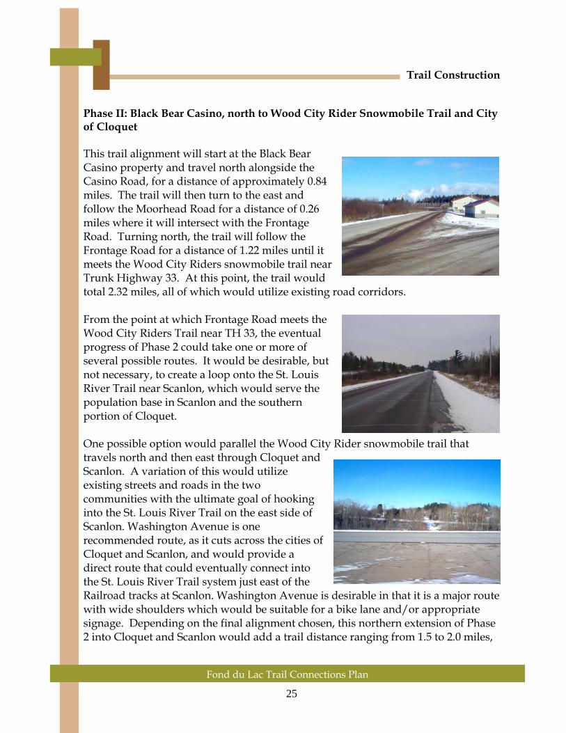
Phase II: Black Bear Casino, north to Wood City Rider Snowmobile Trail and City of Cloquet This trail alignment will start at the Black Bear Casino property and travel north alongside the Casino Road, for a distance of approximately 0.84 miles. The trail will then turn to the east and follow the Moorhead Road for a distance of 0.26 miles where it will intersect with the Frontage Road. Turning north, the trail will follow the Frontage Road for a distance of 1.22 miles until it meets the Wood City Riders snowmobile trail near Trunk Highway 33. At this point, the trail would total 2.32 miles, all of which would utilize existing road corridors. From the point at which Frontage Road meets the Wood City Riders Trail near TH 33, the eventual progress of Phase 2 could take one or more of several possible routes. It would be desirable, but not necessary, to create a loop onto the St. Louis River Trail near Scanlon, which would serve the population base in Scanlon and the southern portion of Cloquet. One possible option would parallel the Wood City Rider snowmobile trail that travels north and then east through Cloquet and Scanlon. A variation of this would utilize existing streets and roads in the two communities with the ultimate goal of hooking into the St. Louis River Trail on the east side of Scanlon. Washington Avenue is one recommended route, as it cuts across the cities of Cloquet and Scanlon, and would provide a direct route that could eventually connect into the St. Louis River Trail system just east of the Railroad tracks at Scanlon. Washington Avenue is desirable in that it is a major route with wide shoulders which would be suitable for a bike lane and/or appropriate signage. Depending on the final alignment chosen, this northern extension of Phase 2 into Cloquet and Scanlon would add a trail distance ranging from 1.5 to 2.0 miles,

26
Trail Construction
Fond du Lac Trail Connections Plan
for a total of 3.8 to 4.3 miles from Black Bear Casino to the connection with the St. Louis River Trail in Scanlon. Alternative Route The Alternative Route could be utilized in lieu of either Phase 1 or Phase 2, if circumstances do not allow for trail construction as outlined in those sections of this document. The Alternative Route has certain advantages, but is also a compromise route in the sense that it is 1) longer than the direct connection that would be provided to the Munger Trail in Phase 1; and 2) does not serve the population areas of Cloquet and Scanlon to the extent of Phase 2; and 3) is not conducive to usage by snowmobile traffic during winter months, as would be Phase 2. The Alternative Route begins at Black Bear Casino and travels north along the same route as Phase 2, utilizing the Casino Road and Moorhead Road for a distance of 1.1 miles. From here, the trail would continue to travel in an easterly direction, following Moorhead Road across the bridge at I-35 and into the residential area east of the Interstate for a distance of 0.73 miles where Moorhead Road intersects with County Road 3 and County Road 107. From this point, the trail would follow County 3 for a distance of 1.2 miles, where it would connect to the St. Louis River Trail near the northern boundary of the City of Carlton. This final segment would require a crossing of the BNSF railroad where County 3 currently crosses. The Alternative Route would utilize the existing Moorhead Road Bridge crossing over I-35. This bridge is presently too narrow to accommodate bicycle traffic; so the Alternative Route would necessitate a widening of the bridge to allow for a barrier between traffic and the trail, on both sides of the bridge. Likely costs to complete this widening range from $1.2 to $1.5 million. Another option may be the construction of a separate pedestrian bridge, which may alleviate some of the cost associated with the widening of the Moorhead Road Bridge.
27
Trail Construction
Fond du Lac Trail Connections Plan
The Alternative Route would total approximately 2.95 miles from the Black Bear Casino to the intersection with the St. Louis River Trail. From that intersection, the distance to the Munger Trail is 0.95 miles to the south via the St. Louis River Trail. When compared to a Phase 1 trail connection, the Alternative Trail adds nearly 6 miles of travel for a trail user trying to access the Black Bear Casino from the southern portion of the Munger Trail. From the City of Carlton Trailhead, the distance to Black Bear Casino via Munger/Phase 1 is 5 miles, compared to 3.9 miles for the Alternative Trail. While slightly longer, it is anticipated that many Carlton residents would prefer the Munger Phase 1 route since it does not follow roads to the extent of the Alternative Trail. Trail/ Road Intersections The Fond du Lac Trail will intersect several high volume / high speed roadways. Several potential crossings are at non-signalized mid-block locations. Motorists are typically not expecting the presence of mid-block crosswalks, therefore, important safety standards must be incorporated into the design of these intersections. To be effective and safe, the trail/ road intersection should be designed to:
• Alert motorists and trail users to the approaching intersection • Provide clear guidance on the rules-of-the-road • Allow clear visibility between motorists and trail users • Minimize crossing distances • Provide accessible solutions
Alert Motorists and Trail Users to the Approaching Intersection Careful placement of signage and pavement markings is needed on both the roadway and trail to alert motorist and trail users to the presence of the intersection. Advance warning signs and pavement markings should be placed at an adequate distance from the intersection given the speed of the traffic. Trail identification signage, set back outside the road right-of-way, also acts as a warning of the approaching intersection. Provide Clear Guidance on the Rules-of-the-Road Clear guidance through signage and pavement markings as do the rules-of-the-road and rights-of-way needs to be provided to both the motorists and trail users. Marking a crosswalk clarifies that a

28
Trail Construction
Fond du Lac Trail Connections Plan
legal crosswalk exists at that location and it indicates to trail users the best place to cross the road. The typical yellow diamond shaped crosswalk signs that are frequently used to indicate the presence of the crosswalk to motorists are not recommended because research has shown that they poorly identify the exact location of the crosswalk and do not explicitly indicate that the motorist is required to yield. As an alternative, the “Yield to Pedestrians Here” sign, shown to the right is recommended in conjunction with a yield bar. This combination clearly indicates to motorists the need to yield to pedestrians in the crosswalk and the optimum location at which to stop to maximize visibility between crosswalk and roadway users. Signs located along the trail at major access points should indicate the rules of the trail. Pavement markings at the beginning of the trail should notify users of direction of trail and right-of-way regulations. However, pavement markings further along the trail should be minimized to avoid visual clutter. Allow Clear Visibility between Motorists and Trail Users The ability of pedestrians to see motorists is equally as important as their own visibility in the roadway. The trail should meet the roadway at or as close to a 90-degree angle as possible for maximum visibility. Wide white ladder crosswalk markings are recommended instead of the standard marking of two parallel lines because the ladder crosswalks are more visible and resistant to tire wear.
29
Trail Construction
Fond du Lac Trail Connections Plan
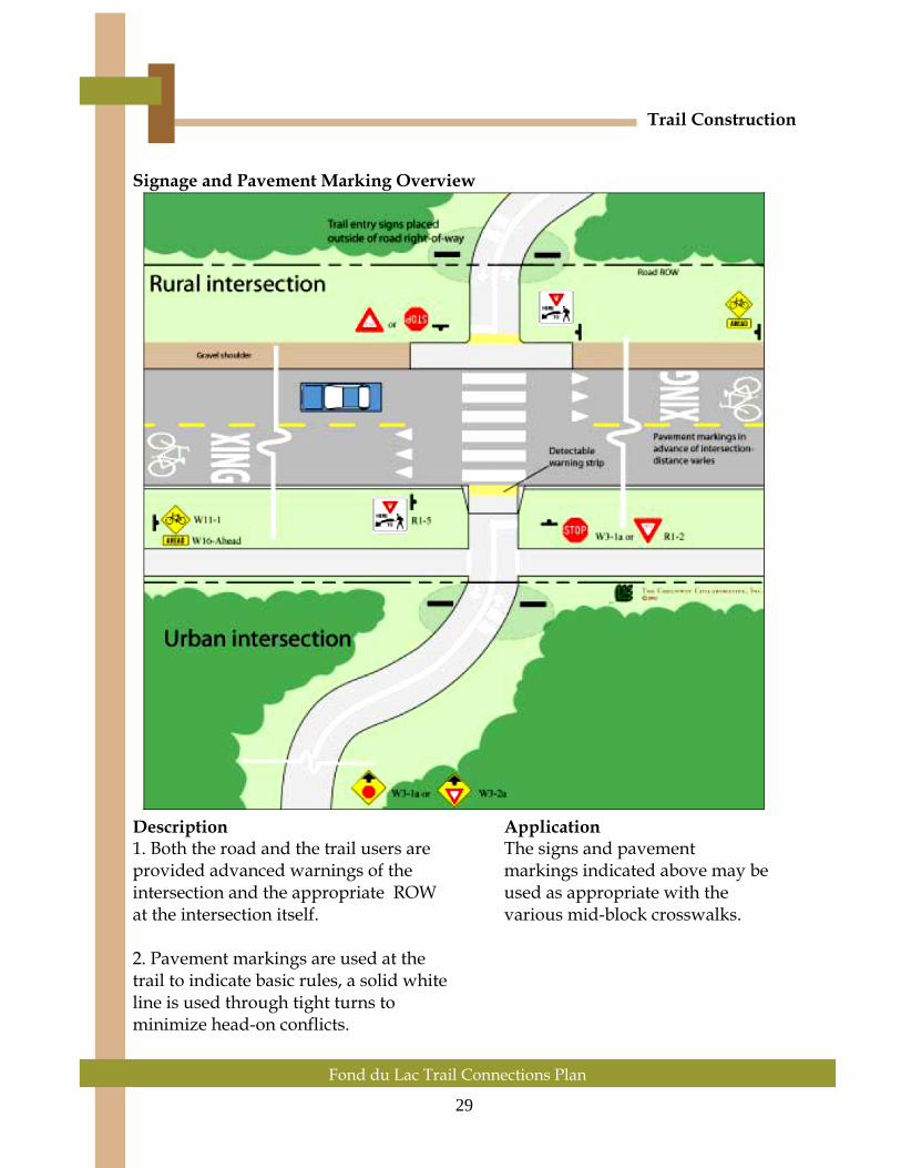
Signage and Pavement Marking Overview
Description Application 1. Both the road and the trail users are The signs and pavement provided advanced warnings of the markings indicated above may be intersection and the appropriate ROW used as appropriate with the at the intersection itself. various mid-block crosswalks. 2. Pavement markings are used at the trail to indicate basic rules, a solid white line is used through tight turns to minimize head-on conflicts.

30
Trail Construction
Fond du Lac Trail Connections Plan
Road Crossing Locations and Recommendations Phase 1: Highway 210 at Black Bear Co. 61 at Douglas Rd. Phase 2: Moorhead Road at Frontage Road TH 33 in Cloquet Railroad Crossing at Scanlon Various in-town intersections Alternative Route: Moorhead Road, Bridge over I-35 Phase 1: Highway 210 at Black Bear Casino The proposed trail alignment crosses Trunk Highway 210 just west and south of the Black Bear Casino. This intersection is scheduled to be signalized in 2008-2009 and it is recommended that the trail crossing be located in the vicinity of the signal. This crosswalk should be striped.

31
Trail Construction
Fond du Lac Trail Connections Plan
Phase 1: County Road 61 at Douglas Road The trail alignment for Phase 1, would cross County Road 61 at the Douglas Road; where the trail would then tie into the Munger Trail. Adequate striping, yield bars, and signage will be needed at this location.

32
Trail Construction
Fond du Lac Trail Connections Plan
Phase 2: Moorhead Road at Frontage Road The trail alignment for Phase 2 would bring the trail across Moorhead Road in the vicinity of Frontage Road. This crossing is located near the western end of the Moorhead Road bridge over I-35, and the north end of the Casino Road. Striping, yield bars, and signage will be needed at this trail crossing.

33
Trail Construction
Fond du Lac Trail Connections Plan
Phase 2: TH 33 along Wood City Riders Trail If Phase 2 is considered, the trail would follow in the general path of the Wood City Riders snowmobile trail which crosses Trunk Highway 33 just to the north of a high-traffic interchange with Interstate 35. A suggested alternative to the current snowmobile crossing would be located 0.5 miles to the north, at the controlled intersection leading to Wal-Mart. Striping, yield bars, and effective signage will be required at this location.

34
Trail Construction
Fond du Lac Trail Connections Plan
Phase 2: Railroad Crossing at Scanlon On the east side of Scanlon, near Highway 45, there is presently a marked snowmobile trail crossing of the Railroad Tracks. This may be an ideal location for the Phase 2 trail to cross the tracks, as it is very close to the proposed St. Louis River Trail.
35
Trail Construction
Fond du Lac Trail Connections Plan
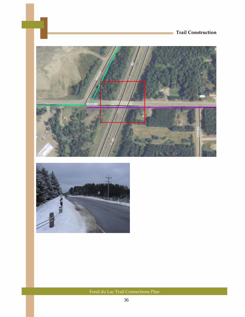
Phase 2: Various in-town intersections If Phase 2 is considered, there will be several crossings of streets in Cloquet and Scanlon. Adequate signage and striping is encouraged for those crossing locations. Alternative Route: Moorhead Road, Bridge over I-35 If the Alternative Route is chosen over Phase 1 or Phase 2, the Moorhead Road bridge over Interstate 35 presents a special set of circumstances. Standards require a barrier between traffic and the trail, so the road shoulder needs to continue at 6-feet, then the barrier and 10-feet of trail with railing at the outside edge. Both sides would need the same treatment so bicycles aren’t required to cross traffic in order to cross the bridge. The subsequent widening of the bridge would total approximately 36 feet. The bridge is 230-feet long, so the total square footage of the project would be 8,280 sq. ft. Cost estimates for bridge widening average $150/sq. ft. The resulting estimate for this bridge widening project is $1,242,000, although extra dollars should be considered for the necessary grading of the roadway to fit the sections together. If it is possible to widen the road without the traffic barrier, the widening could be reduced to 10-12 feet each side, with reduced costs. Another option which needs to be considered is the construction of a separate pedestrian bridge. It is possible that such a bridge may come in under the cost required for widening of the existing Moorhead Road vehicle bridge over I-35.
36
Trail Construction
Fond du Lac Trail Connections Plan

37
Trail Construction
Fond du Lac Trail Connections Plan
Trail Amenities and Access Points Providing adequate support facilities for trail users at regular intervals along the trail is essential to the long-term success of the trail. Clustering trail facilities such as restrooms, drinking fountains, trash receptacles and picnic areas along the trail has several benefits. Grouping these amenities makes them more visible and recognizable to trail users moving along the trail. Clustering the facilities reduces visual clutter along the trail, reduces environmental impact of the facilities and can minimize degradation of the trail on areas along the river. Rest areas should have easy access by maintenance vehicles and plenty of room for negotiating bicycles so that groups can gather without interfering with the trail throughway. Because of the cost of constructing and maintaining restrooms and parking areas, it is often advantageous to utilize existing facilities, adding elements as needed. This also provides a good way to introduce people to the trail. Rest Area A full service rest area is a likely starting point for a visitor from out of town as well as providing support to trail users. Typical Elements:
• Restroom • Car Parking Area • Orientation Kiosk • Trash/Recycling Bins • Water • Bike Racks • Benches • Picnic Areas • Donation Box

38
Trail Construction
Fond du Lac Trail Connections Plan
Access Point An access point is a low key facility providing a minimum of amenities that is typically used by people familiar with the trail who are generally self sufficient. Typical Elements:
• Car Parking Area • Orientation Kiosk • Trash/Recycling Bin
A logical access point is the Black Bear Casino property. It is likely that the Black Bear property could contain a full service Access Point, complete with restroom facilities, orientation kiosk, parking/bike unloading area, bike racks, picnic areas, water, and more. There may be locations within the City of Cloquet or the City of Scanlon that could also be designated as an access point, with appropriate parking facilities and amenities.

39
Trail Construction
Fond du Lac Trail Connections Plan
Interpretation System
Interpretive signage along the Fond du Lac Trail Connection can give the trail a unique character and increase people’s appreciation of the history of the area. There are many different opportunities for interpretation along the trail.
Whatever features are chosen for interpretation along the trail, careful and thoughtful use of signage can greatly enhance a user’s experience of the trail. Several important considerations for the design and use of interpretive signage are:
• Keep signage consistent in design along the length of the trail to establish a
sense of continuity and character. Repetition of sign design, color scheme or logo along the trail reinforces the image of a common trail identity through different jurisdictions.
• Signs should be clearly legible, understandable, and be made of fade-proof and weather-proof surface materials and inks.
• Signs should be durable and require minimal maintenance.
• Signs should be placed to prevent obstruction or collision along the trail. Place signs in clear areas at least 4 feet off the side of the trail so groups of pedestrians, wheelchair users or people on bicycles can be completely out of the travel lane while reading signs.
• Self guided interpretive systems with simple numbered posts may be used along the trail. The river overlooks may be used for large interpretive signs that introduce the tour and as a place to distribute self-guided tour pamphlets.
40
Trail Construction
Fond du Lac Trail Connections Plan
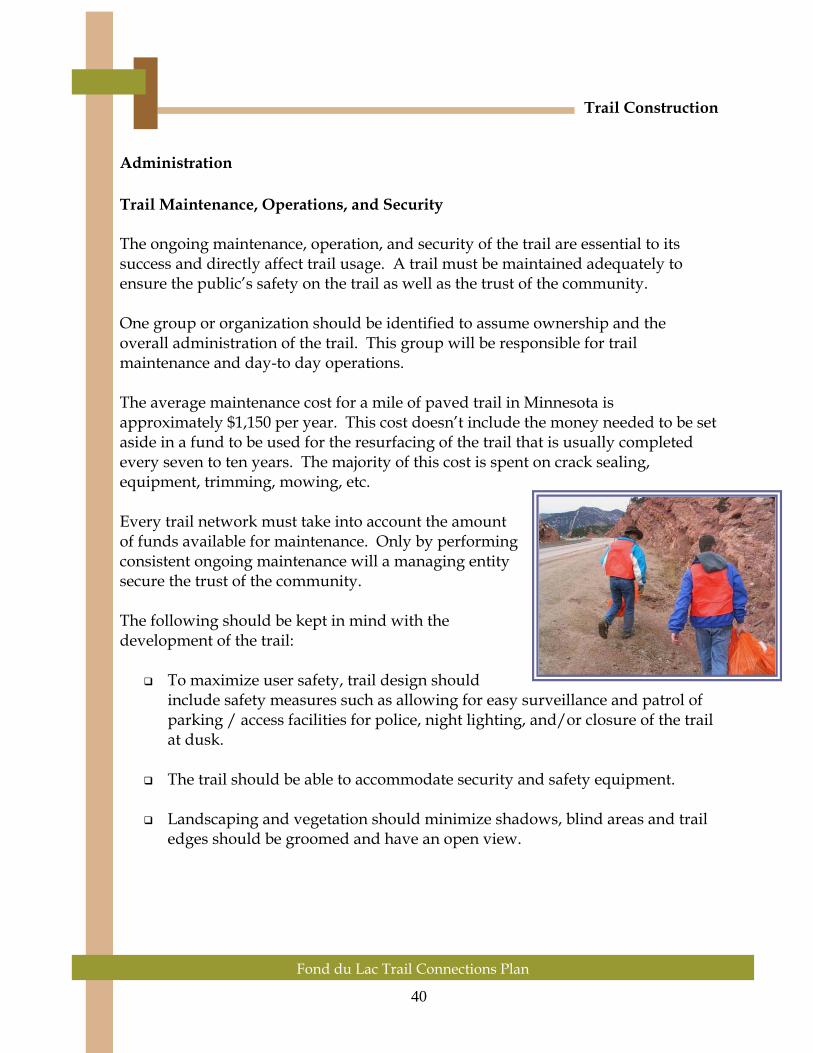
Administration Trail Maintenance, Operations, and Security The ongoing maintenance, operation, and security of the trail are essential to its success and directly affect trail usage. A trail must be maintained adequately to ensure the public’s safety on the trail as well as the trust of the community. One group or organization should be identified to assume ownership and the overall administration of the trail. This group will be responsible for trail maintenance and day-to day operations. The average maintenance cost for a mile of paved trail in Minnesota is approximately $1,150 per year. This cost doesn’t include the money needed to be set aside in a fund to be used for the resurfacing of the trail that is usually completed every seven to ten years. The majority of this cost is spent on crack sealing, equipment, trimming, mowing, etc. Every trail network must take into account the amount of funds available for maintenance. Only by performing consistent ongoing maintenance will a managing entity secure the trust of the community. The following should be kept in mind with the development of the trail:
To maximize user safety, trail design should include safety measures such as allowing for easy surveillance and patrol of parking / access facilities for police, night lighting, and/or closure of the trail at dusk.
The trail should be able to accommodate security and safety equipment.
Landscaping and vegetation should minimize shadows, blind areas and trail
edges should be groomed and have an open view.

41
Fond du Lac Trail Connections Plan
Trail Construction
Volunteers Volunteers play an integral role in a trail project. Their efforts help reduce the cost of trail construction and maintenance so it is essential to create a successful volunteer program for every trail project. In order to accomplish this it is helpful to understand what motivates people to donate their time and energy to volunteer for a program or project. People volunteer for a variety of reasons, ranging from service reasons to a desire to help for social reasons. In addition, people continue to volunteer for a project because of recognition, respect, and a sense of accomplishment. The first step in finding volunteers is to identify organizations and individuals who are likely to support and participate in the project. Good sources of volunteers for a trail project include organizations such as the Boy Scouts and Girl Scouts, the Sierra Club, biking and hiking trail clubs, birding clubs, and local civic organizations. These community resources are all good places to recruit volunteers for help in both the construction of the trail and organizing fundraisers. A good method to attract volunteers is to distribute a press release to all local newspapers and media outlets explaining the project, the benefits to the volunteer and what will be expected of recruits. A trail brochure can easily be created and can also be used as a volunteer recruiting method by adding an area in which interested persons can identify their area of interest, such as trail construction, maintenance, and trail monitors. A program that has worked for other trails is an “Adopt-a-Trail” program. Participants choose to adopt a section of the trail and become responsible for periodic trash pick-up and they may also choose to plant trees and install site amenities along their section of the trail as long as they are consistent with the overall trail plan. This program is successful because individual volunteers become responsible for their own section of trail instead of the entire trail. Another program that has been successful in raising funds and awareness is the “Buy-a-Foot” program. Under this initiative, citizens are encouraged to purchase one linear foot of the trail by donating the cost of construction. Participants can be given gifts as a thank you, such as a T-shirt and certificate.

42
Fond du Lac Trail Connections Plan
Trail Construction
Once a good volunteer base has been established, it is important to train and retain the people who have shown an interest to helping this cause. It is also important to make sure that the volunteers stay educated on trail issues and gain a sense of fulfillment or satisfaction. Keep things fun and have the equipment necessary to complete the tasks that will be required of them. If possible, reward the volunteers and always remember to thank them for all that they do. Funding One of the major constraints for a trail project is funding. While utilizing non-federal sources has many benefits, federal funding sources will be needed to provide adequate facilities along the Fond du Lac Trail Connection. In 1991, Congress enacted the Intermodal Surface Transportation Efficiency Act (ISTEA). This six-year bill authorized a wide range of federal-aid transportation programs, including programs that fund trail acquisition and development, In June of 1998, the Transportation Equity Act for the Twenty-First Century (TEA-21) was enacted and expands on those programs that have greatly benefited trail programs. The two programs that are most likely to provide access for trail funding remain the Northeast Minnesota Transportation Enhancements program and the Recreational Trails program. Transportation Enhancement Provisions Funding for the following activities is available:
1. Bicycle and pedestrian facilities 2. Acquisition of scenic easements and scenic/historic sites 3. Scenic or historic highway programs 4. Landscaping and scenic beautification 5. Historic preservation 6. Rehabilitation and operation of historic transportation buildings, structures,
or facilities 7. Preservation of abandoned railway corridors 8. Control and removal of outdoor advertising 9. Archeological planning and research 10. Mitigation of water pollution due to highway runoff and provision of wildlife
under-crossings for protection of endangered or threatened species 11. Provision of safety and educational activities for pedestrians and bicyclists 12. Establishment of transportation museums

43
Fond du Lac Trail Connections Plan
Trail Construction
Approximately $3.6 billion nationally in federal funding has been made available for Transportation Enhancement Activities over the life of TEA-21. In Northeast Minnesota $1.5 million annually is available for trail construction though this program. This funding is aimed at helping projects fund the cost of trail construction. Recreational Trail Program Provisions of TEA-21 Under TEA-21 the Recreational Trails Program guarantee approximately $45 million in annual funding. The State Trail Coordinator is the contact for funding information, and works for the Department of Natural Resources. Funding is available for acquisition, construction, and management of recreational trail facilities. Other funding sources:
• Community Development Block Grant Program funds cities and towns for projects with community-wide benefits. Trails can qualify for Community Development Block Grants (CDBG) money, particularly those with documentable economic, cultural and historic elements.
• National Highway System funds may be used to construct bicycle transportation facilities and pedestrian walkways on land adjacent to any highway on the National Highway System (not including the interstate system).
• Surface Transportation Program (STP) funds may be used for either the construction of bicycle transportation facilities and pedestrian walkways or non-construction projects (such as brochures, public service announcements, and route maps) related to safe bicycle use. Ten percent of Surface Transportation Program funds are used for “Transportation Enhancements” which includes a provision for bicycle and pedestrian facilities.
• Congestion Mitigation and Air Quality Improvement (CM/AQ) program funds may be used for either the construction of bicycle transportation facilities and pedestrian walkways, or projects related to safe bicycle use.
• Federal Land Highway funds may be used to construct pedestrian walkways and bicycle transportation facilities on federal land in conjunction with roads, highways, and parkways at the discretion of the department charged with the administration of such funds.
• Scenic Byway funds may be used for a variety of recreational trail programs to benefit bicyclists, pedestrian, and other non-motorized users with an emphasis on bicycle facilities.

44
Fond du Lac Trail Connections Plan
Trail Construction
• Section 402 funding provides highway safety program funds, with an emphasis on pedestrian and bicyclist safety. Title II, Section 2002, of Intermodal Surface Transportation Efficiency Act (ISTEA) addresses state and community highway safety grant program funds.
May 2006 Revisions
Addendum

Fond du Lac Trail Connections Plan
45
Fond du Lac Trail Connections Plan
Revisions Addendum
May 2006 Revisions Addendum On April 13, 2006, representatives of Burlington Northern Santa Fe (BNSF) met with planners from Fond du Lac Reservation, ARDC, and SEH Inc. to consider opportunities for potential trail crossings and shared right-of-way, specifically the I-35 underpass area. Due to the limited space available between the railroad tracks and bridge supports, minimum safety setbacks could not be met at this particular site. As a result, Phase I as written in February 2006 has been determined infeasible, and cannot proceed unless satisfactory alternatives to the BNSF underpass are implemented. The remainder of this section offers alternatives to the BNSF underpass option. BNSF Alternative 1: Underpass (tunnel) below I-35 to Munger Trail. BNSF Alternative 2: Overpass (bridge) above I-35 to Munger Trail. BNSF Alternative 3: Utilize “alternative route” as described in Section 4 (Currently the preferred alternative.)
BNSF Alternative 1: An underpass tunnel enabling pedestrian, bike, and snowmobile traffic under Interstate 35 near the Black Bear Casino. Location of underpass would need to be relatively close to proposed Phase I BNSF underpass to keep remainder of trail as planned. Other locations may work, however the trail alignment would need to be reconsidered due to other properties and features. A second tunnel or bridge may be required for crossing the BNSF tracks nearby. The estimated cost for underpass/tunnel construction is $300,000 to $400,000. BNSF Alternative 2: An overpass bridge enabling pedestrian, bike, and possibly snowmobile traffic over Interstate 35 near the Black Bear Casino. Location of overpass would need to be relatively close to proposed Phase 1 BNSF underpass to keep remainder of trail as planned. Other locations may work, however the trail alignment would need to be reconsidered due to other properties and features. A second bridge or tunnel may be required for crossing the BNSF tracks nearby. The estimated cost for overpass/bridge construction is $300,000.
BNSF Alternative 3: As stated earlier in this document, there is an “Alternative Route” that would take the trail away from the south side of Black Bear, and instead move it generally north and east following existing

46
Fond du Lac Trail Connections Plan
Revisions Addendum
roads (Casino, Moorhead, County 3) to a point where it would intersect with the St. Louis River Trail near Carlton. This alternative route would likely require a widening of the county bridge over I-35, or perhaps a rebuild of the bridge altogether. Fond du Lac and Carlton County may wish to consider sharing the cost of a new bridge if this is determined to be a viable option. The estimated cost for bridge widening is $1.2 million. Another option may be a specific-use bridge for pedestrian/bicycle/snowmobiles near the Moorhead Road crossing, which is estimated at a cost of $300,000. This original “Alternative Route” is generally the preferred option/alternative for the Fond du Lac Reservation at this time, given the engineering and other cost factors that would be required with the other alternatives.
Chapter Five: What is ARDC?


47 Fond du Lac Trail Connections Plan
What is ARDC? The Arrowhead Regional Development Commission (ARDC) is a multi-disciplined planning and development organization whose jurisdiction encompasses the Northeast Minnesota counties of Aitkin, Carlton, Cook, Itasca, Koochiching, Lake, and St. Louis. In accordance with the Minnesota Regional Development Act, the Commission serves as an advocate for local governments in Northeast Minnesota, provides leadership in the development of projects that benefit the Arrowhead Region and serves as a catalyst to identify needs and seek solutions to issues of regional significance. This role is especially important with regard to problems and opportunities that are multi-jurisdictional in scope or impact. Throughout its existence, ARDC has developed numerous planning and implementation programs aimed at meeting the needs of the Arrowhead Region. ARDC also serves as an umbrella agency for a wide variety of local, state, and federal initiatives. These programs include services to aging, human services, transit transportation, metropolitan planning, economic development, community development, and natural resources. Other responsibilities of ARDC include the development and maintenance of resource data to support the preparation of comprehensive development plans for units of government.

48 Fond du Lac Trail Connections Plan
Fond du Lac Trail Connections Plan
Fond du Lac Trail Connections Plan
February 2006
Prepared by: Fond du Lac Planning Department
Facilitated by:
Arrowhead Regional Development Commission
Adopted by the Fond du Lac Reservation Business Committee pursuant to Resolution #1203/06 on August 9, 2006
ARDC’s Mission:
“To serve the people of the Arrowhead Region by providing local units of government and citizens groups a means to work cooperatively in identifying needs,
solving problems, and fostering local leadership”.
If you have any questions regarding ARDC or the Fond du Lac Trail Connections Plan, please contact:
Arrowhead Regional Development Commission
Andy Hubley Regional Planning Division
221 West First Street Duluth, MN 55802
218-529-7512 Toll Free: 1-800-232-0707 ext. 539
FAX: (218) 529-7592 Web Address: www.ardc.org
E-mail: [email protected]