Embed Size (px)
Citation preview
Volume 2015 Article 99
2015
FM 48 Roadway Improvement Project, Wheeler County, Texas FM 48 Roadway Improvement Project, Wheeler County, Texas
Christopher Ringstaff
Follow this and additional works at: https://scholarworks.sfasu.edu/ita
Part of the American Material Culture Commons, Archaeological Anthropology Commons,
Environmental Studies Commons, Other American Studies Commons, Other Arts and Humanities
Commons, Other History of Art, Architecture, and Archaeology Commons, and the United States History
Commons
Tell us how this article helped you.
This Article is brought to you for free and open access by the Center for Regional Heritage Research at SFA ScholarWorks. It has been accepted for inclusion in Index of Texas Archaeology: Open Access Gray Literature from the Lone Star State by an authorized editor of SFA ScholarWorks. For more information, please contact [email protected].

FM 48 Roadway Improvement Project, Wheeler County, Texas FM 48 Roadway Improvement Project, Wheeler County, Texas
Creative Commons License Creative Commons License
This work is licensed under a Creative Commons Attribution 4.0 International License.
This article is available in Index of Texas Archaeology: Open Access Gray Literature from the Lone Star State: https://scholarworks.sfasu.edu/ita/vol2015/iss1/99

Report for Archeological Survey
FM 48 Roadway Improvement Project,
Wheeler County, Texas
Christopher Ringstaff Principal Investigator,
Antiquities Permit No.7230
The environmental review, consultation, and other actions required by applicable Federal environmental laws for this project are being, or have been, carried-
out by TxDOT pursuant to 23 U.S.C. 327 and a Memorandum of Understanding dated 12-16-14, and executed by FHWA and TxDOT.

Report for Archeology Survey, Environmental Affairs Division, Texas Department of Transportation. 2
Abstract
The Texas Department of Transportation (TxDOT) proposes to widen FM 48 from the town of
Mobeetie Texas northward to the Wheeler/Hemphill County line. The Area of Potential Effects
(APE) for the proposed FM 48 improvement project has a length of approximately 9.5 miles
consists within the existing 100-foot ROW. The total area of APE is approximately 115.2 acres
with no proposed new ROW or easements. The maximum vertical depth of impact will be
approximately 5 feet for culvert replacements.
An intensive archeological survey conducted by TxDOT within the FM 48 project area
traversing the recorded site 41WE20. The site consists of the Sweetwater Creek Battlefield
which is a NRHP listed site and is part of the Red River War Battlefields National Register
District. Prior to the survey consultation with THC was conducted for the appropriate survey
methodology. A metal detector survey was conducted on April 2, 2015. During the course of the
survey the west side of the APE was avoided due to extensive grading the presence of buried
utilities. Although the east side of the APE within the delineated area of 41WE20 had a lesser
degree of grading impacts, the shallow grading that had occurred was sufficient to disturb any
potential surficial or shallowly buried items associated with the battlefield. In addition, the
plethora of buried aluminium cans, barbed wire fence hardware and other recent metal items
within the APE.
A TxDOT archeologist evaluated the potential for the proposed undertaking to affect
archeological historic properties (36 CFR 800.16(l)) or State Archeological Landmarks (13
TAC 26.12) in the area of potential effects (APE). TxDOT concludes Based on field
observations and the results of metal detector survey, the proposed undertaking will have no
adverse effect on 41WE20. The site one of several sites that are part of a National Register
District identified as Battle Sites of the Red River War. In addition, the existing ROW of FM
48 that traverses 41WE20 has been sufficiently impacted from prior to road construction
that it should NOT be considered a contributing element the NRHP listed property thus
compelling TxDOT to determine an exception under Section 4(f) regulations (23 CFR 774
and 23 USC 327). Considering the results of the survey, documented existing impacts, and lack
of integrity of 41WE20 within the APE, TxDOT recommends NO additional work is warranted.

Report for Archeology Survey, Environmental Affairs Division, Texas Department of Transportation. 3
Project Identification
Date: 4/9/2015
Date(s) of Survey: 4/2/2015
Archeological Survey Type: Reconnaissance ☐ Intensive ☒
Report Version: Draft ☐ Final ☒
Jurisdiction: Federal ☐ State ☒
Texas Antiquities Permit Number: TAC 7230
District: Childress
County or Counties: Wheeler
USGS Quadrangle(s): Mobeetie
Highway: FM 48
CSJ: 0489-01-020
Report Author(s): Christopher Ringstaff
Principal Investigator: Christopher Ringstaff
Texas Historical Commission Approval
Signature Date
Report for Archeology Survey, Environmental Affairs Division, Texas Department of Transportation. 4
Project Description
Project Type: Bridge replacements
Total Project Impact Acreage: 115.2 acres
New Right of Way (ROW) Acreage: 0.0 acres
Easement Acreage: 0.0 acres
Area of Pedestrian Survey: 18.2 acres
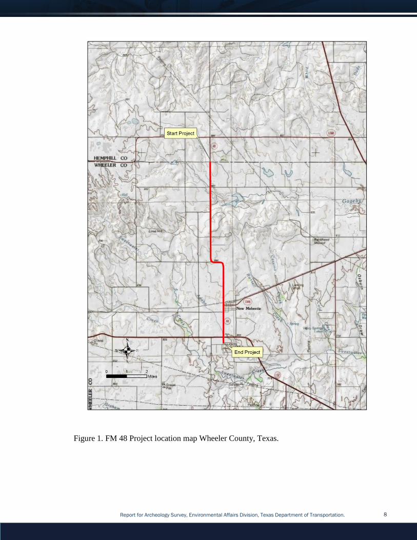
Project Description and Impacts: As shown in the attached project location map (Figure 1),
The Texas Department of Transportation (TxDOT) proposes to widen a 9.5 mile segment of FM
48 in Wheeler County, Texas. The proposed project is a widening of a non-freeway facility
consisting of widening, ACP overlay,and multiple culverts extended on FM 48 in Wheeler
County. The existing roadway typically consists of two-10' travel lanes, one each direction with
no paved shoulders. The proposed project will have two-11' travel lanes with a 3' paved
shoulder on each side and backfill the pavement edges up to 10'. The proposed project will
extend multiple culverts along the roadway to accommodate the widening. All work will be
done within the existing mowed/maintained ROW that has been previously disturbed for
transportation use. No new ROW/Easements required for this project.
Area of Potential Effects (APE): The Area of Potential Effects (APE) for the proposed FM 48
improvement project has a length of approximately 9.5 miles consists within the existing 100-
foot ROW. The total area of APE is approximately 115.2 acres with no proposed new ROW or
easements. The maximum vertical depth of impact will be approximately 5 feet for culvert
replacements.
Parcel Number(s): N/A
Project Area Ownership: State of Texas.
Project Setting
Topography: The project area is located on the rolling eastern margin of the Southern High
Plains physiographic region of Texas.
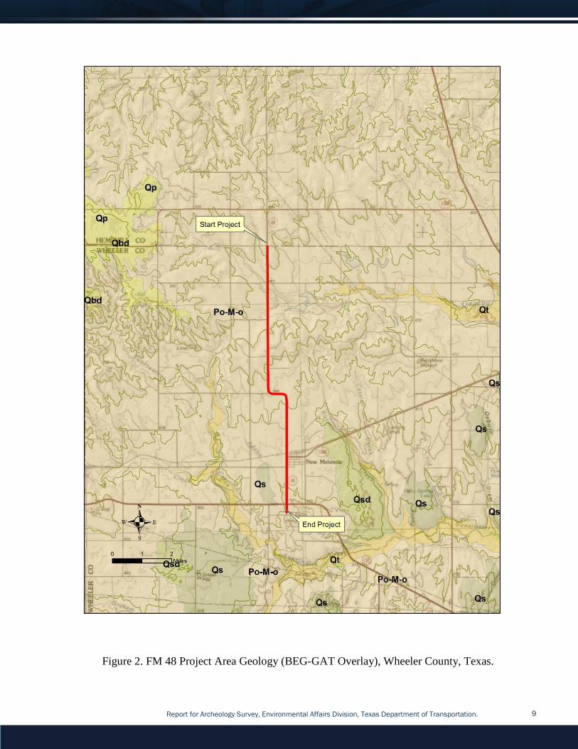
Geology: An overlay analysis using the digitized Economic Geology Plainview Sheet reveals
the project area consists of Pliocene Ogallala Formation (Figure 2).
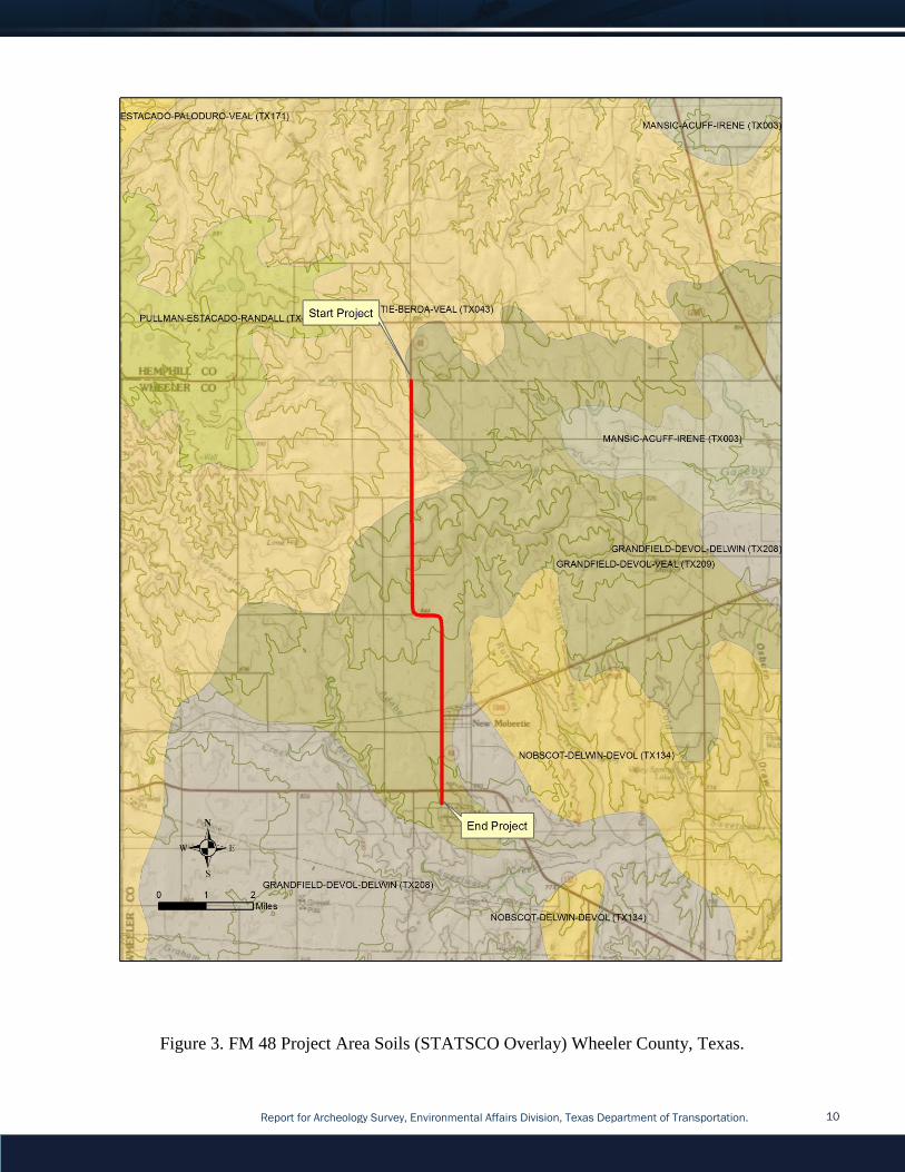
Soils: Based on an overlay analysis using the USDA State Soil Survey Geographic Database
(STATSGO) data reveals soils in the project area consist of Grandfield-Devol-Veal Complex
(Figure 3).
Report for Archeology Survey, Environmental Affairs Division, Texas Department of Transportation. 5
Land Use: Transportation
Vegetation: Grasslands.
Estimated Ground Surface Visibility: Typically poor due to thick grasses approximately 10%.
Comments on Project Setting: The project area is located on a ridge line along which the
Sweetwater Creek Battle was conducted.
Previous Investigations and Known Archeological Sites: A records review by TxDOT staff
archeologists included a review of the Texas Historical Commission’s Archeological Sites Atlas
(Atlas). The Atlas review was conducted on 3/5/2015 and revealed one previously recorded
archeological site within one kilometer of the APE. The site 41WE20 consists of the
Sweetwater Creek Battlefield and is within the FM 48 project area. The roadway traverses the
site 41WE20 which is a NRHP listed site and part of the Red River War Battlefields National
Register District.
Surveyors: Christopher Ringstaff.
Survey Methods: The survey consisted of an Intensive Pedestrian Survey as defined
by13TAC26. Due to the scope of the overall project, it would typically be considered as one
with no potential to effect Archeological Historic Properties of State Antiquities Landmarks.
However, the presence of 41WE20 (Sweetwater Creek Battlefield) in the central portion of the
APE necessitated archeological survey since 41WE20 is part of a multi-site National Register
District identified as Battle Sites of the Red River War.
The methods used for the survey of 41WE20 within the FM 48 ROW were developed in
consultation with staff from the Texas Historical Commission including Brett Cruise and Mark
Denton in on March 26, 2015. It was determined that a metal detector survey would be
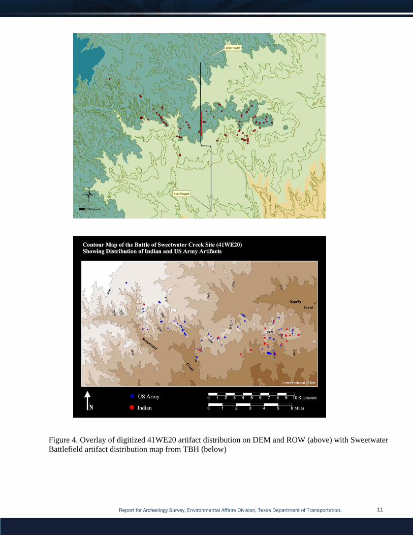
appropriate in area of the ROW that appeared to have lesser construction impacts. Prior to
consultation a GIS overlay analysis of the digitized artefact distribution was conducted to better
understand the approximate spatial relationship to the 41WE20 battlefield and the proposed FM
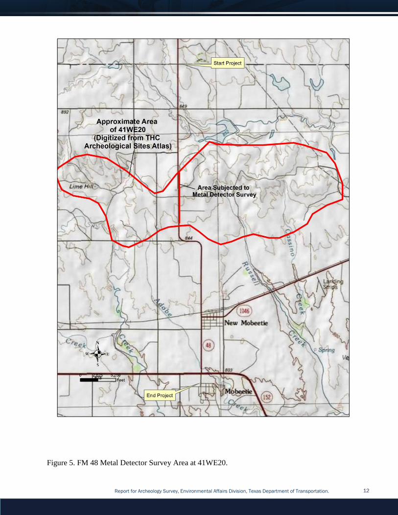
48 project (Figure 4).
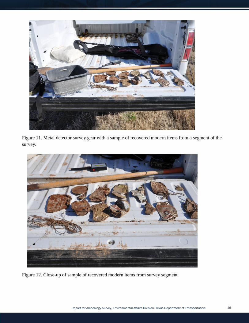
A Whites DFX metal detector and a small handheld detector were used for the survey. Only
artifacts associated with 41WE20 and not modern trash would be recorded using DGPS.
Athough the survey of the APE as a whole deviates from the Minimum Survey Standards as set
forth by the Texas Historical Commission and Council of Texas Archeologists, this deviation,
as mentioned, was developed in consultation with staff from the Texas Historical Commission.
Subsurface Excavation:
Each metal detector signal was probed to identify the associated metal object.
Collection and Curation: NO ☒ YES ☐ If yes, specify facility.
Report for Archeology Survey, Environmental Affairs Division, Texas Department of Transportation. 6
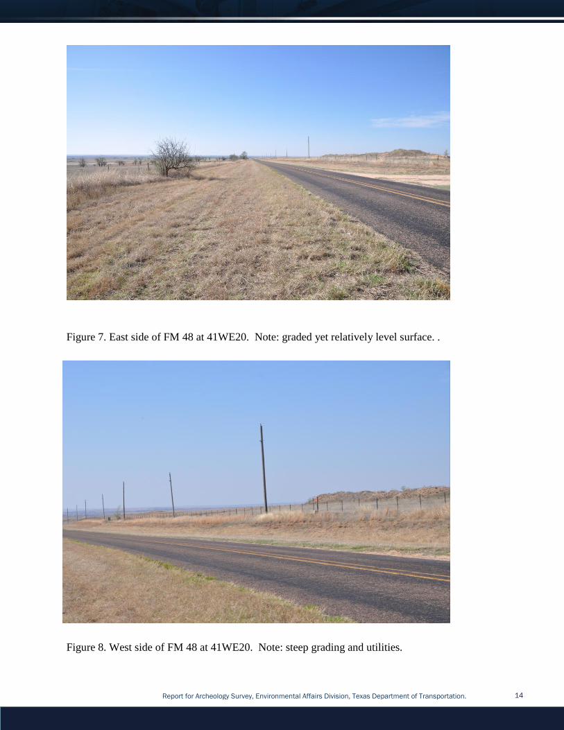
Survey Results Upon arrival upon the project area it was clear that the east side of the FM 48 ROW that
traversed 41WE20 has a lesser degree of prior roadway construction blading/ grading impacts
and opposed to the sharply bevelled western side of the ROW (Figures 6 through 8). Toward
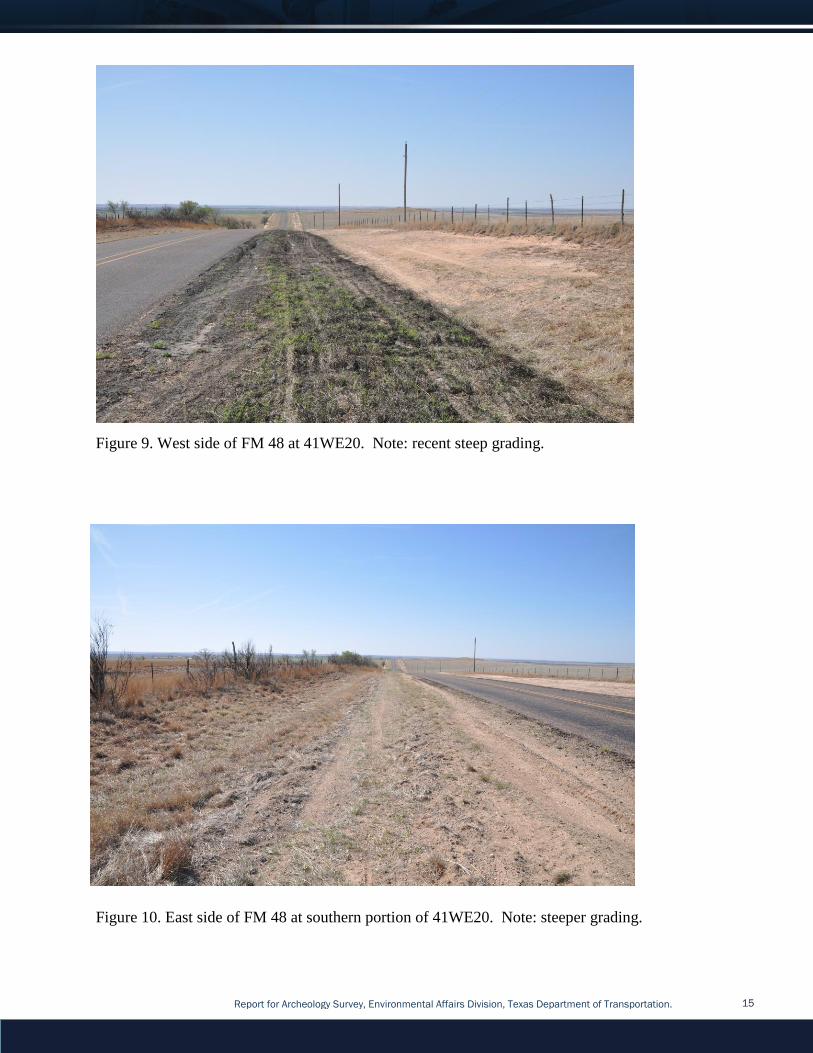
the southern extent of 41WE20, the grading on the east side became sufficiently extensive that
no survey was conducted in this area (Figure 9). Nevertheless, a transect approximately 1.4
miles in length was conducted on the east side of the FM 48 ROW almost completely traversing
41WE20 (see Figures 4 and 5).
During the course of the survey, the extend of buried modern debris became more and more
apparent. It particular, aluminium beer cans were the most common item recovered although
bailing wire, barbed wire, nails, pull tabs, and auto and tractor hardware account for many of
the other items found (Figures 10 and 11). Despite the many modern items cluttering the
roadside magnetic landscape, the survey continued along the 10-20-foot swath of ROW
adjacent to the fence line that had any potential for surface integrity.
Once the survey was completed it was clear that depth of the many buried modern metal items
indicated that prior roadway construction, particularly grading (see Figures 6-9) has impacted
the exiting ROW to a degree that ant items that may have even been present have been scoured
and removed from their context. In addition, based on the GIS overlay analysis conducted prior
to the survey, the ROW was in a low density portion of the battlefield (see Figure 4) and even
without the prior roadway construction there would have likely been few if any artifacts
associated with 41WE20 found.
Recommendations A TxDOT archeologist evaluated the potential for the proposed undertaking to affect
archeological historic properties (36 CFR 800.16(l)) or State Archeological Landmarks (13
TAC 26.12) in the area of potential effects (APE). TxDOT concludes Based on field
observations and the results of metal detector survey, the proposed undertaking will have no
adverse effect on 41WE20. The site one of several sites that are part of a National Register
District identified as Battle Sites of the Red River War. In addition, the existing ROW of FM
48 that traverses 41WE20 has been sufficiently impacted from prior to road construction
that it should NOT be considered a contributing element the NRHP listed property thus
compelling TxDOT to determine an exception under Section 4(f) regulations (23 CFR 774 and 23 USC 327).
Considering the results of the survey, documented existing impacts, and lack of integrity of
41WE20 within the APE, TxDOT recommends NO additional work is warranted. Project
planning can also proceed, in compliance with 13 TAC 26.20(2) and 43 TAC 2.24(f)(1)(C) of
the MOU. If unanticipated archeological deposits are encountered during construction, work in
the immediate area will cease, and TxDOT archeological staff will be contacted to initiate post-
review discovery procedures under the provisions of the PA and MOU.

Report for Archeology Survey, Environmental Affairs Division, Texas Department of Transportation. 7
APPENDIX A. FIGURES
Report for Archeology Survey, Environmental Affairs Division, Texas Department of Transportation. 8
Figure 1. FM 48 Project location map Wheeler County, Texas.
Report for Archeology Survey, Environmental Affairs Division, Texas Department of Transportation. 9
Figure 2. FM 48 Project Area Geology (BEG-GAT Overlay), Wheeler County, Texas.
Report for Archeology Survey, Environmental Affairs Division, Texas Department of Transportation. 10
Figure 3. FM 48 Project Area Soils (STATSCO Overlay) Wheeler County, Texas.
Report for Archeology Survey, Environmental Affairs Division, Texas Department of Transportation. 11
Figure 4. Overlay of digitized 41WE20 artifact distribution on DEM and ROW (above) with Sweetwater
Battlefield artifact distribution map from TBH (below)
Report for Archeology Survey, Environmental Affairs Division, Texas Department of Transportation. 12
Figure 5. FM 48 Metal Detector Survey Area at 41WE20.

Report for Archeology Survey, Environmental Affairs Division, Texas Department of Transportation. 13
Figure 6. Close-up aerial view of FM 48 Metal Detector Survey Area at 41WE20.
Report for Archeology Survey, Environmental Affairs Division, Texas Department of Transportation. 14
Figure 7. East side of FM 48 at 41WE20. Note: graded yet relatively level surface. .
Figure 8. West side of FM 48 at 41WE20. Note: steep grading and utilities.
Report for Archeology Survey, Environmental Affairs Division, Texas Department of Transportation. 15
Figure 9. West side of FM 48 at 41WE20. Note: recent steep grading.
Figure 10. East side of FM 48 at southern portion of 41WE20. Note: steeper grading.
Report for Archeology Survey, Environmental Affairs Division, Texas Department of Transportation. 16
Figure 11. Metal detector survey gear with a sample of recovered modern items from a segment of the
survey.
Figure 12. Close-up of sample of recovered modern items from survey segment.