Embed Size (px)
Citation preview

FLYING FERRIES AND MOVING PAVEMENTS?Pedestrian routing on rare modes of transport
Guillaume Rischard @grischard user/Stereo
Some of humanity’s most beautiful cities are built next big geographical obstacles, next to cliffs, valleys and canyons, rivers and bays. What makes a lot of sense when
you’re a knight building a castle is less convenient when in 2018 you want to walk to work. I’m going to go through the infrastructure city builders have invented to get
over unforgiving topography faster and more easily. It’s expensive, so we usually build it only where it makes overwhelming sense. So because it’s very significant for
cities, mappers tag it well. Most routing engines though tend not to understand it and miss the advantage it can give. As you’ll see, routing would be easier in some
cases than others.

3
2
8
18
1
1
2
6
33
First of all, a very quick refresher on how routing engines work. (Something like:) You turn your road network into edges, give each of them a score, and try to find the way
from A to B with the lowest score - the lowest cost, if you will. So to route over anything, the routing engine needs to know it exists, and what its score should be, which
is something that’s always going to be somewhat subjective - do you prefer to spend less time, less energy, less money? Routing engines authors all try to create
abstractions and models that strike a compromise, and that’s why you get different results from different engines.

ROUTE=FERRY20219 ferries
Ferries are quite common. We have more than 20k ferry routes in the database. The ones that interest for pedestrians aren’t the large car ferries but more the small boats
ferrying people over rivers and lakes - typically less than one or two km. This one crosses the harbour in Hamburg and carries more than 9 million passengers a year.
How do you map them? Connect your road network on both sides with a `route=ferry`. Routing is easy enough: just follow the line at a slightly higher speed. The most
common routing engines support ferries, and I think we can adapt the routing engine profiles so that many of the unsupported modes of transportation are handled a bit
like ferries.

BRIDGE=MOVABLE
BRIDGE:MOVABLE=TRANSPORTER
12 transporter bridges
Transporter bridges, for example, are extremely rare - there are about 12 in the world. You build a tall bridge over your harbour, then hang a platform from it that goes
back and forth. This one near Bilbao in Spain saves a 10 km detour if you want to cross the harbour, runs 24/7, and costs pedestrians 35 cents. Is it a ferry? A flying
ferry? Not really. Does it do what we want it to do if we tag it as ferry? Yes, and two of the twelve have been tagged as `route=ferry`. The others, to make them routable,
have been tagged as `highway=[footway|path|service]`. We don’t want to tag for the renderer, so routers and renderers should understand the bridge:movable=transporter
tag, and just treat it as a ferry synonym.
CONVEYING=*
HIGHWAY=STEPS OR HIGHWAY=FOOTWAY
10819 escalators or travelators
Ferries aren't the only pieces of infrastructure that can easily be mapped with one way. I thought escalators were just used indoors and travelator only in airport terminals,
but they’re an important part of pedestrian navigation. If you want to do proper pedestrian routing in Hong Kong here, you must understand the Central–Mid-Levels
escalators, that carry by 80 000 passengers per day. If the `conveying` tag is present on a highway, we can set the speed on that segment to be a bit higher, and give no
weight to any change in elevation and no penalty for steps. The speed over that segment should be a bit higher, and the cost perhaps lower because you can just stand
still if you want.
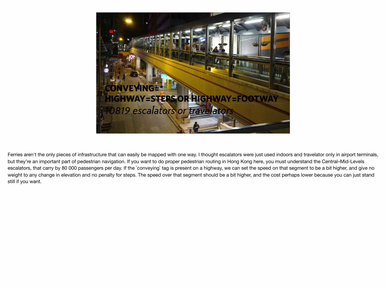
HIGHWAY=ELEVATOR17108 elevators
Another very common piece of infrastructure, with 17k tagged objects, are lifts. The tagging is simple, and naive routing engines that ignore elevation might get lucky
because they just take the shortest path. But they might get the duration wrong (duration=* tag), and the shortest path isn’t always the quickest. It might make sense to
skip the lift to go down the hill, or to walk down a bit to take the lift up.
For this lift in Luxembourg, a niche was dug into the cliff, then the concrete pillar with the lift goes up, then there's a bridge connecting the top of the pillar to the upper
city. I was bugging Richard Fairhurst a lot because cycle.travel didn't want to route using that lift no matter what. It turns out that the routing model was looking at the
elevation data, and didn't know about the niche that had been dug into the cliff. So it would see that cliff with the lift halfway up, and think, there's no way I'm cycling up
that! Setting an `incline` tag on the way that connects the road to the lift fixed that.
What it did correctly assume that the bridge was flat. Sometimes you see other routers that are too clever by half, and think that a bridge will follow the curvature of the
valley it crosses. Bridges should be assumed to be straight from one end to the other, unless there’s an incline tag on them.

ROUTE=FUNICULAR
RAILWAY=FUNICULAR
108 route relations,1367 railways
People have mapped funiculars and incline elevators meticulously, mostly using the public transport v2 schema - stop positions at the end of the rails, and a platform on
the side of that. The stop position isn't connected to the platform, and the platform isn't always connected to the road network. To route over that, we need to pre-
process the data to create virtual connections if necessary, between the stop position and the nearest platform, or platforms if they're tagged as entry_only or exit_only.
Then, we can walk our pedestrian to the platform and from there to the train, and then we can handle the funicular like we handle our ferries. People movers, the little
automatic trains that move people across airport terminals, can be treated the same. There’s one here in Milan called the MeLa, connecting a metro station on the M2 to
a hospital.
There’s another way of tagging those, using a highway=elevator way that’s connected to the road network on both ends. Those we can just route as a ferry.
[explain difference incline elevator (autonomous) / funicular (two cabins as counterweight)]
This one in Paris carries around 4 million passengers per year. When it closed for maintenance in 2006-2007, shopkeepers complained that their income was down
20-30%.

AERIALWAY=CABLE_CAR
AERIALWAY=GONDOLA
1385 gondolas, 1325 cable cars
We have also mapped aerialway in different ways, by tagging the ends as nodes or buildings. It’s almost but not entirely not unlike the public transport v2 tagging.
We can easily treat most aerialways, from cable cars to gondolas, as funiculars - it doesn’t matter to the router if you’re on a rail or on a cable.

USER INTERFACE
Fee/Free?
Avoid ferries -> avoid moving infrastructure?
Wheelchair important
THANK
YOU
Guillaume Rischard @grischard
osm.org/user/Stereo
Picture credits:
Porto incline elevator: Tj Holowaychuk https://unsplash.com/photos/MUHe6nNMXVI
Hamburg Ferry: Huhu Uet CC-BY-SA https://commons.wikimedia.org/wiki/File:Elbmeile_(Ship,_2005)_01.jpg
Vizcaya transporter bridge: Javier Mediavilla Ezquibela CC-BY-SA https://commons.wikimedia.org/wiki/File:Zubia_jun.jpg
Hong Kong Central-Mid-Levels Escalator: Hwoofuangmei CC-BY-SA https://commons.wikimedia.org/wiki/
File:HK_Central_footbridge_night_%E9%96%A3%E9%BA%9F%E8%A1%97_Cochrane_Street_May_2016_DSC.jpg
Pfaffenthal Panoramic Lift: Luxemburger Wort, photographer unknown. https://luxtimes.lu/archives/4797-pfaffenthal-lift-closure-for-further-maintenance-work
Roosevelt Island Tram: New York State, photographer unknown. https://rioc.ny.gov/302/Tram
User interface: pieced together from Apple Maps settings screenshots