Embed Size (px)
Citation preview


Flows and Aesthetics:
A Guide to Concepts and Methods
May 2017
Doug Whittaker and Bo Shelby
Support provided by
National Park Service Hydropower Assistance Program Hydropower Reform Coalition
Confluence Research and Consulting Oregon State University

Foreword
River users increasingly realize that the aesthetics of rivers- the way they look and feel- provide experience as special as being on a river or physically touching the water. In the United States, federal and state laws and agency mandates recognize the aesthetic values of water, and require adequate flows and other measures to maintain and protect these values. However, state and federal agencies do not apply these laws often, and when they do, it is not always done consistently. This is due, in large part, to the absence of clear protocols for assessing and protecting aesthetic values of water. This guide is intended to fill that gap and improve decision-making. It provides a common framework for requesting, designing, or reviewing flow-aesthetics studies, and reviews specific methods for conducting those studies. It will help participants (including regulators, applicants, agencies, tribes, and other stakeholders) involved in proceedings such as federal hydropower licensing processes or water right adjudications. The goal is to better understand, assess, and design flows to protect aesthetic resources. This guide complements other flow-related documents produced jointly by the Hydropower Reform Coalition and the National Park Service, such as the Flows and Recreation Guide, and the Hydrokinetic Energy Projects & Recreation: A Guide to Assessing Impacts. The authors are recognized experts in the field of flows for aesthetics and recreation and have been extensively involved in navigability litigation, water right adjudications, and hydropower licensing. Joan Harn, Cassie Thomas and Susan Rosebrough of the National Park Service, Mark Ivy and Vince Yearick of the Federal Energy Regulatory Commission, and Rich Bowers, Megan Hooker and Rupak Thapaliya of the Hydropower Reform Coalition provided reviews on an earlier draft. Joan Harn Rupak Thapaliya River Programs Manager National Coordinator NPS/Conservation and Outdoor Recreation Programs Hydropower Reform Coalition National Park Service www.hydroreform.org www.nps.gov/hydro
June 2017 Washington, D.C.

Flows and Aesthetics: A guide to concepts and methods Page i
Table of Contents
1. INTRODUCTION ............................................................................................................................................... 1
Objectives ................................................................................................................................................. 1 Limitations ................................................................................................................................................ 2 Guide organization .................................................................................................................................... 3
2. CONCEPTS ....................................................................................................................................................... 4
Definitions ................................................................................................................................................. 4 A conceptual framework ........................................................................................................................... 6
3. DECISION SETTINGS AND STUDY PROCESSES ............................................................................................. 7
Decision settings ....................................................................................................................................... 7 Licenses for hydropower development ................................................................................................ 7 Water quality certification .................................................................................................................... 8 Wild and Scenic River designation ...................................................................................................... 10 Other state laws or regulations .......................................................................................................... 11
Alaska .............................................................................................................................................. 12 Idaho ............................................................................................................................................... 12 Hawaii ............................................................................................................................................. 12 Vermont .......................................................................................................................................... 13 California ......................................................................................................................................... 13
A progression of study options ............................................................................................................... 15
4. A REVIEW OF STUDY METHODS ................................................................................................................. 17
Historical photos ..................................................................................................................................... 18 Systematic photography through a range of flows................................................................................. 19 Physical characteristics in cross sections ................................................................................................ 21 Simulating “unobservable” flows ............................................................................................................ 23 Expert evaluations .................................................................................................................................. 25 Panels and survey-based evaluations ..................................................................................................... 28 Hydrologic modeling and other desktop methods ................................................................................. 30
5. INTEGRATING AESTHETICS WITH OTHER RESOURCE VALUES ................................................................ 32

Flows and Aesthetics: A guide to concepts and methods Page ii
6. EXAMPLE FLOW-AESTHETIC STUDIES AND PROJECTS ............................................................................. 33
Niagara Falls ............................................................................................................................................ 33 Kootenai Falls, Montana ......................................................................................................................... 35 Saint Anthony Falls .................................................................................................................................. 36 Bond Falls ................................................................................................................................................ 37 Superior Falls ........................................................................................................................................... 37 Yantic Falls............................................................................................................................................... 38 Snoqualmie Falls ..................................................................................................................................... 39 Virgin River .............................................................................................................................................. 40 Barberville Falls ....................................................................................................................................... 41 Shoshone Falls ......................................................................................................................................... 42 Tallulah Gorge ......................................................................................................................................... 43 Shepaug River ......................................................................................................................................... 44 Spokane Falls ........................................................................................................................................... 45 Middle Spokane River ............................................................................................................................. 47 Similkameen Falls .................................................................................................................................... 48
7. BACKGROUND, EVALUATION APPROACHES, AND CLASSIFICATION SCHEMES .................................... 51
Distinguishing aesthetics and recreation ................................................................................................ 51 Descriptive vs. evaluative information ................................................................................................... 52 The philosophical roots of aesthetics ..................................................................................................... 53 Visual Resource Management approaches............................................................................................. 55 Types of waterfalls and subjective waterfall evaluations ....................................................................... 56
Geometric classifications .................................................................................................................... 56 Evaluation / classification systems...................................................................................................... 58
8. CONDUCTING FLOW-AESTHETIC STUDIES ................................................................................................. 59
Collaboration with stakeholders and the public ..................................................................................... 59 Measuring flows and using gage information ......................................................................................... 60 Choosing key observation points and taking photos/video ................................................................... 62 Conducting successful flow-aesthetic surveys ........................................................................................ 64 Channel coverage vs. aesthetic value ..................................................................................................... 67
9. CONCLUSION: SIX FLOW-AESTHETIC PRINCIPLES ..................................................................................... 68
REFERENCES....................................................................................................................................................... 69
Cover Photo: Similkameen Falls, Washington was the focus of aesthetic studies and litigation described on page 48. (Photo by Tom O’Keefe, American Whitewater)

Flows and aesthetics: A guide to concepts and methods
1
1. Introduction
I gave my heart to the mountains the minute I stood beside this river with its spray in my face and watched it thunder into foam, smooth to green glass over sunken rocks, later to foam again. I was fascinated by how it sped by and yet was always there; its roar shook both the earth and me.
Wallace Stegner Rivers plunging over waterfalls are among the grandest spectacles in nature, scenic wonders that attract millions of visitors. The aesthetic qualities of flowing water have several elements, but the amount of water is among the most important. The magic of viewing waterfalls clearly depends on the sight, sound, and feel of moving water. Other activities such as hiking or picnicking along a river are less flow-dependent, but they are clearly enhanced by the beauty of water as it glides through canyons or splashes over riffles. Federal laws and agency mandates recognize the aesthetic value of water in rivers, and protect flows or related scenic elements in the landscape. But the language is often general or abstract, and is seldom used explicitly to manage flows for aesthetics. It is often assumed that flows for other resources such as fish or recreation will protect aesthetics, but river professionals need better protocols for assessing and protecting aesthetics independent of other resource considerations. This guide is intended to address these needs. It applies established principles and methods from flow-recreation research, a branch within the larger field of recreation management, to systematically assess how flow affects aesthetic evaluations and related recreation experiences. Designed for river professionals (including resource managers, utility staff, consultants, and advocates), it describes theory and practices agencies can use to determine whether flow regimes protect or enhance aesthetic resources.
Objectives The overall goal of this guide is to describe the current state of flow-aesthetic research and the ways it can be integrated into a variety of decision-making settings (including hydropower licensing, water rights adjudications, and protecting scenic values of state of federally designated rivers). The hope is to provide a common framework for those conducting studies, and others who review and use that work. This includes researchers, consultants, and staff from agencies, utilities, and interest or user groups. Specific objectives include:
Clarify and standardize terminology.
Differentiate between descriptive and evaluative components and show why they should be considered separately.
Describe several study options for specific situations.
Identify study outputs that fit with decision-making processes.
Discuss strategies for integrating aesthetic studies with those for other resources.

Flows and aesthetics: A guide to concepts and methods
2
Consider ways to use study information to develop efficient and effective protection, mitigation, and enhancement measures.
In many cases, the document focuses on studies used in Federal Energy Regulatory Commission (FERC) licensing and State 401 Water Quality Certification, because these processes apply to flows on regulated rivers that can directly affect aesthetics. But similar information also can be used in decision settings such as state instream flow protection, water right adjudications, or non-FERC dam operations. In all these settings, the common need is to show how flow regimes affect aesthetics and related recreation experiences, and then integrate with findings from other resources in decision-making processes. This document is not a cook book for conducting studies; it is designed to establish a framework for studies and review the key concepts. High quality flow-aesthetic studies require scientific, logistical, and visual media skills, as well as experience adapting social science concepts and methods to specific cases. Similarly, a growing flow-aesthetics literature offers examples of study elements such as individual survey questions or data analyses, but these often require modification to be effectively applied to other places. This document provides guidance about the issues to be considered when requesting, designing, conducting, or reviewing flow-aesthetics studies, but it is not a recipe for designing studies or navigating the scientific literature. In the same way that a guide to fish habitat methods does not replace biological expertise, this guide does not replace social science expertise.
Limitations Research in this field is relatively young, although there is increasing consensus about issues and the ways they can be addressed. The guide is intended to catalyze additional dialog to build on this progress, with the hope that additional studies and concepts will be added to the guide in the future. This guide recognizes that the aesthetics of rivers are affected by larger landscapes where other variables are factors. There are several visual resource management protocols for assessing landscape aesthetics, some of which focus on human modifications (such as forestry practices or construction of new facilities). This guide is not intended to summarize, duplicate, or supplant those protocols. A discussion section reviews some of the conceptual and methodological overlap in Chapter 7. This guide focuses on the aesthetics of flows in rivers and creeks or over waterfalls, not water levels in lakes or reservoirs. But many of the principles and methods for assessing aesthetics in river settings can be adapted to lakes and reservoirs; both involve systematic evaluations of a biophysical variable that may affect scenic beauty or related resources.

Flows and aesthetics: A guide to concepts and methods
3
Guide organization The guide is organized into nine chapters.
Introduction. Provides an overview and limitations of the document.
Concepts. Defines terms, describes a conceptual perspective, and links the flow-aesthetics field to larger literature in the social sciences and philosophy of aesthetics.
Decision settings and process. Reviews laws and agency policies designed to protect or enhance aesthetic flows in rivers, and presents a study process that can be adapted to different decision settings.
Study options. Presents choices ranging from professional judgments to larger-scale studies with on-site assessments of multiple flows. For each, we review objectives, the typical approach, study output, additional issues, and cautions/limitations.
Integrating with flow studies for other purposes. Considers efficiencies in studying flows for aesthetics along with other resources, as well as ways to integrate study findings to optimize flow regimes that provide for different resources over different time scales.
Example studies and projects. Illustrates methods and findings from ten rivers, showing how studies or applications were more vs. less useful in resolving aesthetic issues.
Background, evaluation approaches, and classification schemes. Collects several discussions that provide conceptual background for understanding aesthetics, or ways that scientists or resource managers have evaluated visual resources in general or waterfalls in particular.
o Distinguishing aesthetics and recreation
o Descriptive vs. evaluative information
o The philosophical roots of aesthetics
o Visual Resource Management approaches
o Types of waterfalls and subjective waterfall evaluations
Conducting flow aesthetic studies. Collects several technical discussions about conducting flow-aesthetic studies.
o Collaboration with stakeholders and the public
o Measuring flows and using gage information
o Choosing Key Observation Points (KOPs) and shooting photos/video
o Constructing successful flow-aesthetic surveys
o Channel coverage vs. aesthetic value
Six flow-aesthetic principles. Summarizes major findings from existing studies into generalizations, hypotheses, or suggestions for future research.

Flows and aesthetics: A guide to concepts and methods
4
2. Concepts This chapter defines terms, describes a general conceptual framework, and links flow-aesthetic issues to extensive literatures in philosophy and related social sciences.
Definitions Several terms are commonly used in flow-aesthetic studies. Different technical meanings are sometimes intended, and common usages can add to the confusion. We offer the following definitions for clarity. Aesthetics. This term is used broadly to refer to “the study of the mind and emotions in relation to the sense of beauty,” or to identify a branch of philosophy addressing “the principles of beauty in art and nature” (Dictionary.com, 2015). It is used in everyday language to describe objects or scenes that are “pleasurable to the senses,” or “pleasing and attractive” (Merriam-Webster, 2015). There is an extensive literature related to the philosophical roots of aesthetics, generally focused on the question: what is beautiful? Originally used to define beauty in art, philosophers began applying aesthetic principles to nature in the 19th century. In the last 50 years, environmental aesthetics (Morton, 2007) has integrated those concepts with other ideas from environmentalism, psychology, and social psychology. A discussion section in chapter 7 provides a brief review. Our focus is more applied, referring to empirical evaluations of visual (scenic) beauty or other sensory experiences in a landscape setting, including sound, touch, smell, or taste. When considering river settings, these empirical studies can involve experiences as diverse as the sight of a powerful cataract, the sound of a bubbling creek, the temperature of a swimming hole, the mist of a waterfall, or the smell and taste of a glacial creek. This applied focus is also distinct from spiritual values or religious rights associated with different flows in a river or waterfall. For example, Native Americans considered sufficient waterfall mist at Snoqualmie Falls, WA to be a sacred component of their religious ceremonies, but court rulings during hydropower relicensing separated this topic from aesthetics (see discussion on Snoqualmie Falls in chapter 6 for a summary). Recreation. Recreation refers to experiences people have while participating in goal-directed, non-work activities. It includes a long list of physical and contemplative activities, including nature-focused activities such as hiking, biking, boating, swimming, and camping. People are motivated to recreate for several reasons, including physical and psychological benefits such as enjoying nature, fitness, taking risks, developing skills, testing competency, gaining social recognition, being with friends and family, introspection, and escaping social pressures (Brown et al., 1978). Recreation research and management frameworks suggest that resource agencies manage settings to provide opportunities for high quality experiences. Aesthetics may be important parts of these experiences, involving evaluations of the environments where recreation occurs (see discussion on Recreation and Aesthetics in chapter 7).

Flows and aesthetics: A guide to concepts and methods
5
Scenic values or scenic beauty. These terms are commonly interchanged with aesthetics. However, we consider scenic values or scenic beauty to be more narrowly focused on visual evaluations, while aesthetics includes other senses. Landscape and landscape scale. Dictionary definitions focus on “the visible features of land” (Merriam-Webster, 2015) or “the entire portion of territory that can be viewed from one place” (The Free Dictionary, 2015). Visual resource literature includes more narrowly defined landscape scales (see below), as well as more expansive definitions that combine a landscape’s physical features with human perceptions of them. In ecological discussions, landscape-level solutions often refer to larger regional, national, or continental scales (in contrast to smaller sites). For our purposes, landscape generally refers to a viewshed visible from a particular location. Similarly, we adopt the Forest Service (1995) distinctions between different scales as below:
Immediate foreground 0 to 300 feet
Foreground 300 feet to ½ mile
Middle ground ½ mile to 4 miles
Background 4 miles to horizon Given that most river channels with flow-aesthetic impacts are less than a half-mile wide, most flow-aesthetics studies will involve foreground or immediate foreground scales. These scales are similar to Litton and Tetlow’s (1973) “setting unit,” which is distinct from their larger “landscape unit.” Regardless of the label, the focus is on intimate interaction with the sights, sounds, and feel of natural features rather than the patterns and textures of larger scale landscape evaluations.
Flows are more likely to affect the sights, sounds, and feel of natural features in the foreground than patterns and textures of the larger landscape. McCoy Falls on the New River, Virginia.

Flows and aesthetics: A guide to concepts and methods
6
A conceptual framework A conceptual framework for flows and aesthetic resources is shown in Figure 1 (adapted from Whittaker et al., 1993; Whittaker et al., 2005). Flow is the variable driving the system, and it can come from natural or human-regulated sources. Flow, in turn, affects resource conditions, which include immediate effects such as hydraulics (depth, velocity, width, wetted perimeter, and turbulence) as well as longer-term effects related to interactions between hydraulics, channel geomorphology, and riparian vegetation. Taken together, hydraulics, channel morphology, and riparian vegetation form a dynamic system of resource conditions that define biophysical and human “habitats.” Resource outputs are produced when different resource conditions are combined with a given flow regime. Broad categories of outputs include recreation opportunities (e.g., whitewater boating, wading-based fly fishing, swimming, and wading) and biophysical resources (e.g., quality of a sport fishery, amphibian populations, and beach size or abundance). Other possible outputs include different qualities of aesthetic characteristics. For example, lower flows may produce a shallow segmented waterfall with little mist, while higher flows produce a deeper block falls and clouds of mist.
To the extent that flow regimes can be managed to produce different outputs, the final element is resource trade-offs. Here the framework moves from the descriptive arena (where scientists determine how flows affect resource conditions and outputs), to the evaluative arena (where decision-makers, resource managers, and interest groups consider the desirability of different combinations of outputs). These evaluations are generally made in decision-making processes (such as FERC license proceedings, 401 water quality certifications, Wild and Scenic River water right adjudications, or land management planning) where social values (beyond monetary returns) are key considerations.
Figure 1.
A conceptual
framework for
assessing flows and
aesthetics.
Elements, patterns, and processes
Aesthetic Outputs
Trade-offs and Negotiation
Hydraulics
Channel Form
Vegetation
Resource Conditions
Flow
Aesthetic Evaluations

Flows and aesthetics: A guide to concepts and methods
7
3. Decision settings and study processes A river is more than an amenity—it is a treasure that offers a necessity of life that must be rationed among those who have the power over it.
Oliver Wendell Holmes
This chapter reviews laws or agency policies designed to protect or enhance aesthetic flows in rivers, and presents a study process that can be adapted to different decision settings.
Decision settings Aesthetics of water in rivers or over falls can be protected through several federal or state laws (or associated regulations and decision-making processes). The following examples of flow-aesthetic decision settings describe laws or guidelines that mandate or offer opportunities for protection and how they have been used by agencies. The list is not exhaustive.
Licenses for hydropower development
The Federal Energy Regulatory Commission (FERC) regulates approximately 2,500 hydropower dams across the country, with most operated by private utilities or public utility districts. Licenses are usually granted for periods of 30 to 50 years; when those licenses expire, utilities must apply for and receive a new license to keep operating a facility. As of Jan 2017, there were 1,036 active FERC hydropower licenses for existing projects (some covering multiple dams), 629 exemptions, and 165 preliminary permits for new projects. FERC expects to review licensing applications for about 390 projects between 2017 and 2030. The Electric Consumers Protection Act (ECPA) updated the Federal Power Act in 1986, and rewrote the rules for assessing and mitigating impacts of hydropower projects. ECPA requires “equal consideration of power and non-power values,” so a project licensed prior to 1986 may need to consider resources that previously received less attention. Recreation and aesthetics are specified as “non-power values,” and regulations have led to a formal role for the National Park Service to provide advice to stakeholders and to represent recreation and aesthetic interests in relicensing processes. Agencies that manage land affected by hydropower projects (e.g., the U.S. Forest Service, Bureau of Land Management, U.S. Fish and Wildlife Service) have similar responsibilities to consider a variety of environmental values, including recreation and aesthetics. Although aesthetic issues in FERC processes often focus on facility/development impacts (e.g., from dams, penstocks, power houses, roads, and transmission lines), aesthetics of flows affected by project operations are also considered. Hydropower licensing is a complex, multi-year resource planning and decision-making process. The three major phases are handled differently depending on whether the “traditional” (TLP), “alternative” (ALP), or default “integrated” (ILP) process is used. The initial phase assembles existing information about the project and potentially affected resources in consultation with the public. This identifies information gaps, informing which studies are needed to assess the impacts of different operation or mitigation scenarios (see below). A Preliminary Application Document (PAD) is the end product, guided by the standard of presenting “existing, relevant, and reasonably available information.” The baseline

Flows and aesthetics: A guide to concepts and methods
8
for environmental impact assessment are “existing conditions,” but these conditions may be “less natural” for river that has had hydropower development for several decades.
The study phase focuses on developing study plans, completing the studies, and integrating findings across resource areas. This one to two year effort typically culminates in draft and final license applications that document project effects and propose future operations and protection, mitigation, and enhancement measures (PMEs). Most aesthetic studies would be conducted during this phase. Settlement discussions between utilities, agencies, and stakeholders may begin during this period. The final NEPA-based phase focuses on addressing outstanding issues between the utility, agencies, and stakeholders through an impact analysis conducted by FERC using a National Environmental Policy Act (NEPA) process. NEPA requires an agency to consider a range of reasonable alternatives and assess environmental impacts for each. It also requires public involvement and decision-making by an interdisciplinary team. The result is a license to build and/or operate the project, with license articles that prescribe operations and mitigation. When settlement agreements between utilities, agencies, and stakeholders occur, FERC generally incorporates them into the final license. Within each phase of this process, agencies and stakeholders have general responsibilities to help identify recreation or aesthetic issues; determine study needs; assist with study design, conduct, or evaluation; help integrate study results into application proposals; and facilitate settlements between agencies, utilities, and stakeholder groups. The previous section is revised from the Flows and Recreation guide (Whittaker et al., 2005), with additional information from the Hydropower Reform Coalition Toolkit (HRC, 2015). Additional information about FERC licensing is available at FERC.gov.
Water quality certification The Federal Clean Water Act’s Section 401 allows states to control water quality and instream flows related to any federal license or permit through a “Water Quality Certification” or “401 Certification.” These state-led certifications are associated with several federal permitting and licensing processes such as pollution discharge permits administered by EPA; Section 404 dredge and fill or Rivers and Harbors Act permits administered by the Corps of Engineers; and hydroelectric projects licenses administered by FERC. Several states have developed statutes or regulations under this authority to protect recreation and aesthetic values, although other states have waived Section 401 requirements for hydropower licenses. Examples from the State of Washington are presented below to show the range of issues. They are excerpted from court cases, laws, hearings, or agency guidance related to 401 Certification (Washington Department of Ecology and Washington Department of Fish and Wildlife, 2003; Ecology, 2005).
The Department of Ecology (Dept. of Ecology) can “impose flow conditions in order to protect beneficial uses of a river as identified in state water quality standards” in a 401 Certification (PUD No. 1 of Jefferson County v. Department of Ecology, 511 U.S. 700, 1994).
Dept. of Ecology can require minimum bypass flows in a 401 Certification to ensure “the waters will not be degraded so as to interfere with or injure existing beneficial uses.” (PUD No. 1 of Pend Oreille County v. Department of Ecology, 146 Wn. 2d 778, 821, 2002).

Flows and aesthetics: A guide to concepts and methods
9
“Aesthetic enjoyment, which is a characteristic use, includes enjoyment of beauty” (Snoqualmie Indian Tribe v. Ecology, PCHB No.03-156 (Final Findings of Fact, Conclusions of Law and Order, April 7, 2004)).
Dept. of Ecology can set instream flows for any or all of the listed resources and values, and recognizes that some may “overlap” or “are often clearly related…, for example, recreational boating flows for fishing, pleasure, and whitewater are consistent with navigational values. Scenic values likewise support both aesthetic and recreational values” (Dept. of Ecology and WDFW, 2003, p. 10).
Instream flow statutes require instream flow “protection” RCW 90.22.010 or “preservation” (RCW 90.54.030(3)(a)) without specifically defining either term, but Ecology cites common dictionary definitions of “keeping from harm or injury” for both and requires “sufficient flows” for the “protection or preservation of fish, wildlife, scenic, recreation, navigation, water quality, and other environmental values…over the long term” (Dept. of Ecology and WDFW, 2003, p. 10).
Dept. of Ecology has developed a “narrative standard” rather than a numerical standard for recreation and aesthetics in hydropower water quality certifications (Dept. of Ecology, 2005, p. 26). “Narrative criteria are implemented on a case-by-case basis to protect water quality and beneficial uses.”
A two-page section from Ecology’s 401 Water Quality Certification for Existing Hydropower Dams Guidance Manual focuses on recreation and aesthetic issues (Dept. of Ecology, 2005, pp. 53-54). The section includes:
o “Recreation and aesthetics (sight, smell, touch, and taste) are beneficial uses specifically protected in Washington’s water quality standards.”
o Recognition of a “curvilinear relationship between instream flow and recreational benefits” (referred to as a “suitability curve”).
o Examples of recreation activities that may be affected by flow or reservoir levels, including “motor boating, fishing, swimming, wading, rafting, canoeing, kayaking, inner-tubing, and aesthetic enjoyment.”
o Recognition that evaluations (e.g., preferences or acceptability as assessed in surveys) may be needed to assess how flows affect aesthetics. “Water features are often valued for their aesthetic properties. Beyond the mere presence or absence of water features, however, it also is possible to determine preferences for specific attributes of water features themselves (e.g., flow quantity, water clarity).”
o A list of “possible causes of impairment” that includes 1) “direct dam effects such as river hydraulics, water depth, velocity, wetted perimeter, and turbulence;” and 2) indirect effects to “in-channel features such as sinuosity, sediment movement, channel movement, gravel bars, and beaches. Because of flow changes, there also may be changes to riparian vegetation, which, in turn, may affect the recreation experience.”
o Examples of aesthetic impairments that include “placing river flows through turbines,” and “other structural, operational, and indirect effects of dams on the senses. Growth and decay of aquatic plants; fish kills, boats, litter, and human or pet waste…and other problems contributable (sic) to dams or dam operations can affect taste, touch, smell, and sight.”
o Recognition that evaluative information from recreation users is important. “A user-based survey provides an excellent means to get qualitative responses from the user community

Flows and aesthetics: A guide to concepts and methods
10
regarding river conditions. It also offers the opportunity to query users about other aspects of the recreational opportunity in addition to instream flow.”
o A statement that flows for recreation and aesthetics may need to be integrated with “flow needs for other values using an interdisciplinary approach. Some accommodation among uses will likely be necessary because it is unlikely that any flow can simultaneously optimize the needs of all uses.”
o The importance of public involvement for assessing “potentially visually controversial facilities.”
Wild and Scenic River designation The federal Wild and Scenic Rivers Act (WSRA, 1968) is the nation’s primary river conservation law, designating specific river corridors for their “outstandingly remarkable scenic, recreational, geologic, fish and wildlife, historic, cultural or other similar values.” The law protects such rivers in their free-flowing condition (preventing dams and similar water development), and requires Federal agencies to develop management plans that identify, protect, and enhance the specific “outstandingly remarkable values” (ORVs) for each river corridor. Two sections of the WSRA are relevant for this guide. First, scenery is one of the ORVs that could make a river eligible for designation. Pre-designation eligibility studies or management plans for a designated river identify the important scenic characteristics that have created that value, and describe how those characteristics will be protected and enhanced. Descriptions from a recent plan for the Merced River in Yosemite National Park (2014) illustrate the specificity that can be used to describe scenic values of the river, including some that are obviously flow-related.
Overview Throughout its length, the Merced River flows through a scenic landscape that has few parallels. Whether these are views from the river or its banks, whether the views include El Capitan, Half Dome, Yosemite Falls, Vernal Fall, or Nevada Fall, or any of the other landmarks along the river, the Merced River provides a natural complement to Yosemite’s world-renowned scenery. Depending on the stretch of river, the Merced provides a foreground of a flat valley, a rushing and boulder-strewn river, tall waterfalls, or serene lakes. Yosemite Valley Crashing over Nevada and Vernal falls and then meandering quietly under 2,000 foot cliffs, the Merced forms a placid foreground to some of the world’s most iconic scenery. The river enters Yosemite Valley at Nevada Fall, flowing through Emerald Pool and then over Vernal Fall. Once
The Merced River in Yosemite Valley complements and frames iconic features such as El Capitan.

Flows and aesthetics: A guide to concepts and methods
11
in the flat valley, the Merced provides the foreground to many of Yosemite’s most famous landmarks. From the river and its banks, views consist of Yosemite Falls, Bridalveil Fall, El Capitan, Half Dome, and other named and unnamed parts of the cliffs and hanging valleys rimming the valley. Meandering through a sequence of compound oxbows, wetlands, and meadows, the river and its related features provide broadened panoramas. Throughout the valley, views from the river and its banks encompass the lower Montane forest as it rises up to sheer rock faces of granite cliffs and talus slopes, with a flat valley bottom serving as a contrasting foreground. The juxtaposition of granite domes and waterfalls is unique, as is the concentration of river-related views found in Yosemite Valley. The Merced Gorge Descending 2,000 feet in 14 miles, the river is a continuous cascade under spectacular Sierra granite outcrops and domes. Descending from Yosemite Valley, the river becomes a continuous cascade in a narrow gorge littered by massive boulders. Arch and Elephant rocks and other landmarks rise above, all visible from the river and its banks. Canyon walls rise steeply and have many seasonal waterfalls cascading down to the river. Spring and fall bring special parades of colors, from redbuds and other plants warmly flowering in spring to big leaf maples and other trees turning bright colors in fall. Paternoster lakes are a series of glacial lakes connected by a single stream or braided stream system. South Fork Merced River Passing through an untrammeled forested wilderness, the South Fork Merced River forms the centerpiece of some of the Sierra’s wildest scenery. The South Fork Merced River in these stretches is largely inaccessible, with just a few trail crossings above Wawona and none below it. The scenery from the river and its banks is that of an undeveloped Sierra Nevada river valley, with views dominated by forest-cloaked hills, distant peaks, and an untamed river. These are some of the wildest views possible in the Sierra Nevada.
Second, a river’s designation establishes a federal reserved water right to fulfill the purposes of the designation (including water quality, the river’s free flowing nature, and specific ORVs). Federal reserved rights generally set aside unappropriated water available at the time of designation, but Congress has the power to expand or contract water rights at that time. Federally reserved water rights are quantified through court proceedings and state-based adjudications. Adjudications generally occur through basin-wide processes organized through state courts, and may take many years (e.g., the Snake River Basin Adjudication (SRBA) in Idaho processed over 158,000 water right claims over 27 years). Aesthetics was included in the values protected as part of water rights adjudicated for five Idaho WSRs in the SRBA (including the Selway, Lochsa, Clearwater, Middle Fork Salmon, and Main Salmon). More information about federal reserved water rights is available from the Department of Justice: https://www.justice.gov/enrd/federal-reserved-water-rights-and-state-law-claims..
Other state laws or regulations Several states have instream flow laws that define minimum flows for a long list of values, including aesthetics. The following describes six examples of state laws, regulations, and programs to illustrate the range. Several other states have similar laws and programs, but a comprehensive review is beyond the scope of this document.

Flows and aesthetics: A guide to concepts and methods
12
Alaska Alaska has some of the most progressive instream flow laws (Alaska Water Use Act, 1966; AS 46.15.080). It is based on constitutional clauses that recognize water as a public resource, allow its common use, and define public water rights (Article VIII, Sections 3 and 13). An instream flow amendment to Alaska’s Water Use Act in 1980 allows individuals and organizations to apply for instream flow reservations for specific values, and specifies information and analysis to be provided to the Department of Natural Resources (DNR) for adjudicating the request. In a list of ten values, aesthetics is grouped with recreation and parks purposes. Despite being progressive and potentially wide-reaching, Alaska’s instream flow law has not been widely implemented. Although agencies have submitted hundreds of applications for instream flows, there is a growing backlog; as of 2010, the state had granted just 30. Of those granted, most have been for fish resources, and all but two have been granted to State agencies (Fish and Game or DNR itself). The U.S. Fish and Wildlife Service has made 197 requests and had only one granted. BLM has made 13 requests and had one granted; BLM has requested reservations for flows for specifically defined fish, recreation, aesthetics, and other ecological values. Idaho
Idaho illustrates a more typical western-state approach to instream flow protection. Its laws and programs were developed from a combination of legislative actions, statewide water planning, and litigation (Beeman and Arment, 1988). Although the legislature recognized recreation and scenic beauty as beneficial uses of water in several laws, those values were not listed in the Idaho Constitution and it took a 1978 State Supreme Court case (Malad Canyon) to affirm them for public trust protection (Just, 1990). Additional laws and a state-wide program were later developed out of specific protection efforts for the Thousand Springs segment along the Snake River. In general, Idaho instream flow reservations are made by a state water resource board, but such flows can be requested by other state agencies and non-governmental organizations. The broader purposes for protection are public health, safety, and welfare, with specific values including fish and wildlife habitat, aquatic life, navigation, transportation, recreation, water quality, or aesthetic beauty (Idaho Code Chapter 15, title 42). In general, the program has protected flows at minimum rather than optimal levels, with a focus on fisheries resources. There have been a few reservations for scenic resources such as springs and Upper Mesa Falls on the Henry’s Fork of the Snake River. Hawaii Hawaii has instream flow laws that allow protection for fish, wildlife, recreational, aesthetic, scenic, or other beneficial uses, in balance with existing and potential water development. The application
Alaska state law allows individuals, organizations, and agencies to reserve instream flows for aesthetics and other similar values. Falls on the Delta National Wild River.

Flows and aesthetics: A guide to concepts and methods
13
process for flow protection involves several local, state, federal, and university agencies and has been used to set minimum instream flow standards for 376 perennial streams in the state. Most work focuses on flows for ecological purposes, but recreation (e.g., swimming, nature study, and fishing) and aesthetics (scenic views, waterfalls, and tourism) are also listed values. Flow designations are supposed to consider the economic impacts of restricting out-of-stream use. Court challenges have invalidated “status quo” standards, and the state responded with more ambitious standard-setting in the mid-2000s. However, few rivers have received instream flow protection based on the new standards. Vermont Vermont is illustrative of an eastern state (which applies the riparian doctrine in allocating water) that has considered instream flow protection for recreation and aesthetics, offering a statute to protect the “natural flows of Vermont's rivers and streams in the public interest” (State of Vermont, 1993). The law requires the state to consider “all reasonable alternatives to altering stream flow and water conservation measures” before “reduction of the natural flow rate.” The law further requires “a comprehensive analysis of such measures” to help define “a reasoned and rational balance…between legitimate but competing users of the stream.” The laws recognize potential instream interests can include “fisheries, aesthetic qualities, recreational, and potable water supply uses,” but they also assert that “in general, minimum flows adequate to maintain fisheries interests are sufficient to simultaneously maintain acceptable aesthetic qualities and recreational uses.” We have not found any specific case where flows for aesthetic purposes have been calculated separately from those for fisheries. California California has a complicated history of instream flow protection, and its instream flow policies have been revised in recent years. It is illustrative of several western states (including Colorado and Montana) where ecological resources are the focus. In general, laws and policies (Water Code Section 85087, 2010) allow but do not require the state Department of Fish and Wildlife to identify minimum flows for selected streams for fish or related ecological purposes. The State Water Resources Control Board is responsible for reviewing and accepting those minimum flows for Public Trust resources. The law allows flows for stream-related recreation, although most flow protection has centered on endangered fish and frog species. Methods are generally limited to historic hydrology, wetted perimeter standards, and fish passage. These programs generally have not provided instream flow protection for recreation and aesthetics, even though scenic quality of Mono Lake was an issue in the landmark 1983 Public Trust case that partially led to the state’s administrative instream flow protection program.
Washington
Washington is a final example of a western state with robust instream flow protection statutes and regulations, although most have been targeted toward ecological values rather than recreation and aesthetics. The legal authority to set instream flows in Washington rivers emanate from several laws, including the Water Resources Act on 1971 and subsequent amendments, which set minimum water flows (Chapter 90.22 RCW) and direct watershed planning (RCW 90.82.080). The Department of Ecology (Dept. of Ecology) is granted exclusive authority to establish minimum flows for “the purposes of protecting fish, game, birds or other wildlife resources, or recreational or aesthetic values.” It has been systematically developing these “instream flow rules” in 62 geographically-defined watersheds in the state (29 have been completed as of 2016). In tandem with information about water availability in a

Flows and aesthetics: A guide to concepts and methods
14
watershed, the rules can help determine the extent of out-of-stream diversions or groundwater development in a basin. Ecology’s guidelines discuss several methods for assessing flow needs for ecological resources (especially fish), focusing on techniques such as Instream Flow Incremental Methodology (IFIM), toe-width, and wetted perimeter. In several cases, Dept. of Ecology has suggested fish resources act as an “indicator species” for stream health, and minimum flows that protect fish will therefore protect the entire stream. Critics have suggested that flows for fish may not be sufficient to meet recreation or aesthetic values (pending petition to amend Spokane River instream flow rules, 2016). Dept. of Ecology’s instream flow guidance documents recognize user surveys as a viable approach to understanding recreation or aesthetic flow needs, but has only applied these in limited ways and only in rare cases (e.g., 401 Water Quality Certifications for Snoqualmie Falls and Spokane Falls).
Washington state regulations allow flow protection for aesthetics, but most minimum flows have been based on fishery values. Critics suggest these may not be sufficient to protect aesthetics on the Spokane River (shown at rare low flows about 700 cfs).

Flows and aesthetics: A guide to concepts and methods
15
A progression of study options There are often competing issues when considering alternative flow regimes, and it can be challenging to know how much effort to direct toward flow – aesthetic studies. The answer depends on several variables, including the importance of aesthetic features, the impact of possible flow changes, and the level of stakeholder interest. On rivers with several important flow-dependent aesthetic features (e.g., waterfalls or other in-channel features) or where larger flow changes are considered, more intensive studies that produce higher resolution findings will be needed to distinguish the tradeoffs of different flow regimes or the opinions of diverse stakeholders. On rivers with less important aesthetic features or smaller possible flow changes, lower resolution studies may be sufficient to identify consensus concerns. Given such diverse situations, it is difficult to specify a single standard for a “sufficient” flow-aesthetic study. We recommend a progressive approach with phased efforts of increasing resolution. Any assessment should start with information about a river’s aesthetic features, their likely dependence on flows, and potential effects from water development projects. More intensive or detailed studies should then be prescribed in situations that merit them. To be effective, this approach needs 1) a clear sequential framework; 2) standardized terminology for study options; 3) agreement about which study options provide different levels of resolution; and 4) explicit decision criteria to help determine whether the assessment needs to move to the next level. The following framework suggests three levels of resolution, with distinct study options associated with each level. • Level 1 – “desk-top” options. This is the initial information collection and integration phase. It
usually focuses on office-based methods using existing information, or limited interviews with people familiar with flows and aesthetics on the reach.
• Level 2 – limited reconnaissance options. This increases the degree of resolution through limited
reconnaissance-based studies, more intensive analysis of existing information, or more extensive interviews.
• Level 3 – intensive studies. This substantially increases the degree of resolution through more
intensive studies, which may include multiple flow reconnaissance, flow comparison surveys, or controlled flow studies.
This framework has been applied successfully to flow-recreation studies in FERC relicensing proceedings, and it improves studies or applications in several ways. First, it focuses resources on those river reaches with greater interest to stakeholders or with greater impacts from project operations, while reducing workloads on other reaches. This streamlines costs, and is especially useful at projects with multiple dams, powerhouses, and reaches. Second, it provides a transparent and defensible record for all entities (e.g., licensees, stakeholder groups, and agencies) regarding the sufficiency of effort. This should lead to more efficient licensing or adjudication proceedings, and limit legal and administrative challenges. Third, it standardizes methods and improves comparability across situations. This should improve the quality of study products and allow them to be more efficiently used in license proceedings or other decision-settings.

Flows and aesthetics: A guide to concepts and methods
16
Fourth, the transparency of the phased approach allows information to be shared earlier in the process, particularly across disciplines. This encourages earlier discussion of flow needs for different resources (e.g., fish, geomorphology, recreation, and aesthetics), which may help researchers design studies that address conflicts. Integrating information across resources is a major challenge in licensing proceedings; the earlier that potential conflicts are articulated, the more likely researchers can provide information about trade-offs or possible solutions. Finally, there are efficiencies in conducting coordinated studies, particularly if controlled flow releases are part of the study design. Although it is beyond the scope of this report, there are benefits of using this progressive approach with recreation, fisheries, or other resource studies too, with parallel work at the desk-top, initial reconnaissance, and intensive study levels. It is common for such work to occur during similar time frames in FERC processes, but explicit coordination to reduce costs and encourage inter-disciplinary exchanges is less likely.

Flows and aesthetics: A guide to concepts and methods
17
4. A review of study methods This chapter reviews seven methods that can be used to evaluate the aesthetics of flows in rivers or waterfalls. For each, we review the objective, the typical approach, the output, and keys to success. Some assessments involve more than one method to verify or triangulate results. Regardless of the method, the goal is to develop flow evaluation curves showing the overall effect on aesthetics through a range of flows (as discussed on page 52). These curves make evaluations explicit and transparent, and become a focal point for discussions about agreement, disagreement, and enhancement or mitigation actions. They also help identify tradeoffs between aesthetics and other resources such as fish habitat and power generation. Flow evaluation curves are based on several kinds of information, and many assessments use more than one method. For example, a curve may be calculated from quantitative survey data collected from different groups, or developed from experts’ ratings that considered historical photos, photos taken systematically through the natural flow range, simulations of unobservable flows, and site visits (as in the example at the right). The seven methods are distinguished by findings based on:
Historical photos
Systematic photography through a range of flows
Physical characteristics in cross-sections
Simulating “unobservable” flows
Expert evaluations
Survey-based evaluations
Hydrologic modeling and other desktop methods
Flow evaluation curves for Similkameen Falls, Washington from expert evaluations pieced together from historical photos, recent photos, simulations of lower-than-natural flows, and limited site visits.

Flows and aesthetics: A guide to concepts and methods
18
Historical photos Water resource development (e.g., dams, reservoirs, or diversions) may have substantially modified flows in a river or over a falls, and operational constraints may limit the ability to provide a range of flows to evaluate. In these cases, a review of historical photos may help show how a river looked before development. For new project proposals, developing a series of historical and current photos should be a standard step to document the range of existing conditions.
Objective: Describe aesthetic features in a river segment or waterfall through a range of flows.
Typical approach Assemble photos of the river or waterfall with different amounts of flow.
Search for hydrology information to associate flows with the photos.
Array photos from lower to higher flows; identify features that change.
Summarize descriptive changes for consideration in making evaluations about aesthetic differences.
An array of photos may offer opportunities for public or stakeholder evaluations.
Product Array of photos, descriptions of features that change through the flow range, (possibly) evaluations by experts, stakeholders, etc.
Keys to success Matching present-day photos from key observation points (KOPs) to historical photos can make both more relevant.
Historical photos may help develop simulations of flows for which photos are unavailable (such as very low or high flows). Cropping and Photoshop corrections that control extraneous factors (e.g., adjust tint, saturation, or contrast) may aid comparisons.
This method is important for documentation; developing a complete set of photos of aesthetic features through the full range of flows is a fundamental study need.
Historical photos sometimes provide little more than general descriptive information, may be taken from the “wrong” angles for study purposes, and may be difficult to associate with specific dates (and flows).
Examples Similkameen River, WA 401 water quality certification hearing, where historical photos of a dam and waterfall from an earlier project provided the only evidence of near-dry conditions (that no longer occur).

Flows and aesthetics: A guide to concepts and methods
19
Systematic photography through a range of flows Visual information (still photos or video) about river features through a range of flows is central to most flow-aesthetic studies. In many cases, flows vary throughout a year, so it is possible to take visuals at appropriate intervals. The system may be natural or regulated and more or less predictable, but the goal is to capitalize on existing variation in flows to document the range of conditions. A discussion section on “Choosing key observation points and taking phots/video” is included in chapter 8.
Objective: Develop visual media of aesthetic features through a range of flows.
Typical approach Determine key aesthetic features (e.g., waterfalls, rapids, in-channel geologic features).
Identify a limited number of key observation points (KOPs) and develop instructions for taking repeatable photos or video from each KOP.
Identify range of flow variation and assess predictability of flows throughout a year (or shorter time period).
Identify target flows to document, usually at evenly-spaced increments through a defined flow range (such as the typical natural range or a constrained range based on Project parameters).
Set up a schedule to take photos at the target flows. This might be calendar-based for rivers with predictable hydrology, but more opportunistic otherwise.
Array photos/video from lower to higher flows, and identify features that change.
Summarize descriptive changes for evaluating aesthetic differences.
An appropriate array of photos may offer opportunities for expert or panel-based evaluations (see below).
Product Descriptions of features that change through the flow range, with a corresponding set of visual media.
Keys to success Choosing the appropriate number and locations of KOPs is critical (see discussion on KOPS in chapter 8). It generally makes sense to document from a surplus of KOPs, because some may not be usable for a variety of reasons (e.g., lack of differentiated features, challenging photographic problems, poor coverage, etc.).
Target flows are usually evenly-spaced through the flow range, although closer attention to a subset of flows is sometimes warranted (e.g., specific flows from a hydropower operating regime).
Increments between flows should be large enough to present noticeable differences in aesthetics. As a rule of thumb, we have found that changes of less than 20% may be difficult to distinguish, although

Flows and aesthetics: A guide to concepts and methods
20
the low end of the range or waterfalls with complex features may require smaller increments.
The number of target flows depends on the range and increments; there are tradeoffs between more complete coverage vs. respondent burden and data costs. In general, 4 to 7 photos per KOP is sufficient.
Photos taken at similar times of the day help minimize effects of extraneous variables such as lighting, weather, etc. Morning and evening are generally better times for images.
Adjustments using photo-shop may help control extraneous variables (such as tint, saturation, or contrast) when it is impossible to duplicate weather and lighting conditions through the range.
If a river is in cold-weather climates, winter photos with ice formations may be important.
Taking photos is more expensive and logistically challenging in remote settings.
Taking photos from known KOPs at target flows sounds simple, but can be surprisingly challenging. A river’s typical flow range may not occur in a given study year, or can be infrequent and challenging to predict. Flows during a declining limb of the hydrograph may drop slowly, but ends of the range and flashy systems are less predictable, and photographers need to be opportunistic.
In remote settings, high resolution automated field cameras may be employed to take photos at specified intervals (e.g., the same time every morning) to ensure coverage. Maintenance and vandalism are common challenges.
A single photographer is more likely to collect photographs using the same techniques, from the same locations, capturing the same scenic frame. If you use two or more photographers, a sample “template” photo to bring on site is helpful.
Photographers sometimes have other duties (e.g., a ranger with law enforcement or maintenance responsibilities) that may interfere with the objective of a high-quality record.
Examples On the Similkameen River (WA) for a 401 water quality certification hearing, environmental groups engaged a local resident to take photos and video of two falls from five KOPs through a year, documenting eight flows from 365 cfs to 2,300 cfs.
For a study of Upper Spokane Falls, a utility staff person photographed several falls and rapids from 26 different KOPs; the study formally evaluated 10 of these. Flows included 30 cfs (leakage) and 8 flows from 500 to 1,200 cfs. Spring flows are as high as to 20,000+ cfs, but the Project focused on effects between leakage and about 800 cfs.

Flows and aesthetics: A guide to concepts and methods
21
Physical characteristics in cross sections Hydrology studies show consistent relationships between flow and physical characteristics such as depth, width, velocity, or wetted channel (Leopold and Maddock, 1953; Castro and Jackson, 2001). These hydraulic geometry relationships are used to measure flow (see discussion on “Measuring flows” in chapter 8) and to understand how it affects conditions for aquatic life (e.g., certain species and life stages prefer specific depths and velocities) or recreation (e.g., depths and widths for certain craft to pass a critical riffle). Relationships between aesthetics and physical characteristics have not received the same level of attention. But hydraulic geometry shows how flows affect depths or cover a proportion of the channel, two important aesthetic considerations. These relationships can also help with accurate channel widths at different flows for simulations (see discussion on “Simulating unobservable flows” below). Over the long term, systematic data about physical characteristics and aesthetic evaluations may lead to rule-of-thumb “standards” (e.g., “X percent coverage of a channel produces acceptable aesthetics”). These techniques not needed if natural or regulated regimes provide opportunities to study aesthetics at the full range of flows. But for a variety of reasons, some projects require information from beyond the existing flow range.
Objective Model relationships between flow and physical characteristics (e.g., depth, width, and velocity) in a cross section of the river.
Typical approach Choose a representative cross section in a river or for a waterfall.
Measure or model flows (using hydraulic geometry equations) vs. physical characteristics of the channel (e.g., depths, widths, velocities, and wetted perimeter).
Develop graphs or tables that show these relationships.
Use relationships to describe or help simulate aesthetics at the site through a range of flows (when photos are not available).
Determine if there are breakpoints in relationships (i.e., when changes in flows have large effects on characteristics).
Over the long term, associate aesthetic evaluations (using other methods) with physical characteristics to develop “rule of thumb” standards for those characteristics.
Product Graphs/tables of flow vs. physical characteristics and associated aesthetic evaluations for specific locations (see discussion of “Channel coverage vs. aesthetic value” for several European waterfalls in chapter 8).

Flows and aesthetics: A guide to concepts and methods
22
Keys to success Little work has identified specific physical characteristics that define acceptable aesthetics, but studies suggest percent of inundated channel is likely to be important (see Example studies in chapter 7, and Channel coverage vs. aesthetic value in chapter 8).
Depth may be important in smaller rivers with low turbidity.
A measure of turbulence (such as the Froude number; see Magril et al., 2009) could be related to aesthetic judgments in cascades and deserves research attention.
When available, studies should report physical characteristics at flows that provide acceptable and optimal aesthetics to allow analysis of these relationships.
This method is currently most useful for descriptive information, or as input for other methods (e.g., simulations).

Flows and aesthetics: A guide to concepts and methods
23
Simulating “unobservable” flows Aesthetics are visual, and the best ways to assess aesthetics involve “taking a look.” But for a variety of reasons (ranging from project limitations to an imposed time frame for decision-making), sometimes that’s not possible. To assess “unobservable” flows, photographic simulations are an excellent tool. Photo simulations (sometimes labeled montages or composites) involve a variety of techniques to re-touch, combine, recompose, or edit existing visual materials (usually still images) to show more or less water than in the originals. Since the advent of computer-generated imagery (CGI) programs such as Photoshop and Photopaint, most of this work is done on computers. But a computer doesn’t magically do a good job. Useful simulations require an accurate assessment of the decision space, good visual source information, knowledge of rivers and riverbeds, technical expertise with computer programs, and artistic skill.
Objective Represent aesthetic features in a river segment or waterfall at flows that do not occur naturally (or cannot be provided through Project manipulations).
Typical approach Assemble existing historical or other systematic collections of photos with different flows.
Identify the flows depicted in the existing photos.
Array photos from lower to higher flows and identify features that change.
Choose a base photo (usually the lowest-flow photo from the most important KOP) that will be manipulated for simulations.
Choose the target flows to simulate. Consider intervals similar to those between existing photos, to cover the range under consideration, and to represent the most critical decision-points.
If possible, use on-site measurements or cross-section modeling (see discussion on physical characteristics) at known flows to identify the dimensions of water surfaces and riverbed features in existing photos and estimate such widths at other flows in simulations. A grid over-lay may help with measurements and object placement in simulations. More information about software options and simulation capabilities is available from the National Agroforestry Center (http://nac.unl.edu/simulation/index.htm).
Add simulations into the array of existing photos to validate appearance of the new, bigger array. This may be an opportunity for public or stakeholder evaluations or buy-in.
Product An array that covers the relevant range of flows from important KOPs, as needed for evaluation. The array includes one or more simulated images, along with existing photos.

Flows and aesthetics: A guide to concepts and methods
24
Keys to success Some KOP(s) are better candidates for simulations than others. For example, it is easier to simulate sites that have cross-section measurements that affect wetted channel widths or waterfall form.
Simulations are challenging technical efforts that can be expensive. Challenges include learning and using state-of-the art software, applying on-site or modeled measurements, and adding artistic details to realistically portray moving water. There are trade-offs between simulation quality and developing larger numbers of simulations (from more KOPs, or showing more flows).
The array to be evaluated should show meaningful differences, given the decision setting and technical limitations. Smaller flow differences are more challenging to depict in simulations.
The number of flows depicted in the array depends on the quality of information available, resources for collecting more, the decision environment, the feasible range of project flows, and the simulation budget. More depictions also generate costs going forward, including respondent burden and the costs of collecting, analyzing, and reporting data.
It is more challenging to simulate flows substantially higher or lower than flows in existing photos.
Consider collaborating with stakeholders while developing simulations to include their expertise or concerns and reduce the risk of conflict over simulation representativeness.
Examples Photos below show simulations of 30 cfs and 120 cfs flows over a 54-foot dam and a 20-foot natural falls on the Similkameen River, WA for a 401 water quality certification hearing. The base photo was a frontal view at 360 cfs, although simulations were informed by photos from other KOPs at 265 cfs. The proposed project would produce flows of 10 to 30 cfs. The natural falls had side channels with flows of 50 cfs during fieldwork, which helped simulate 30 cfs over the main falls.
Simulated photos of 0 cfs over Enloe Dam and 365 cfs in Similkameen Falls (left) and 30 cfs over the dam and falls (right), based on historical photos, fieldwork, and limited cross-section modeling.

Flows and aesthetics: A guide to concepts and methods
25
Expert evaluations Daniel (2000) describes the “history of landscape quality assessment…as a contest between expert and survey/perception approaches.” Both approaches recognize that aesthetic quality involves visible (or other sensory) characteristics of the site and human evaluations of those characteristics. The expert approach assumes that a trained individual can apply universal criteria from classical models of human aesthetic judgment. Survey approaches empirically measure evaluations of relevant groups and describe statistical characteristics such as averages or levels of agreement (Lothian, 1999). It is beyond the scope of this guide to adjudicate the issues underlying these fundamentally different approaches (see Lothian, 1999; Daniel, 2000; and discussions in this guide about the Philosophical roots of aesthetics in chapter 7). For projects where aesthetics are more important or controversial, it makes sense to consider methods that go beyond the opinion of a single expert. In general, expert approaches have been developed by governmental agencies that need to assess infrastructure or other landscape modification projects (e.g., powerlines, subdivisions, or forest harvests). Prominent systems appear to build from descriptions of landscape attributes (Litton, 1968; 1972) that became codified in specific assessment protocols developed for the BLM (1984) Forest Service (1974; 1995), and National Park Service (anticipated in 2017). These frameworks are based on the premise that trained observers, following systematic guidelines for assessing specific elements, will produce valid and reliable evaluations of landscapes with and without a proposed project. A discussion on visual resource management approaches in chapter 7 reviews some of the common elements in these systems, which could be applied to riverscapes where flow is the independent variable. These frameworks tend to be complex, but one could have experts apply simpler criteria to predict evaluations of the public or other user groups. For example, an expert could focus on visible channel coverage, based on an empirical principle such as “aesthetics improve the most as flows fill the bottom of the channel” (see discussion in chapter 8). An expert could also rate other correlates with aesthetics (e.g., number of plumes, sound levels, or presence of mist). Ratings could be used to produce flow evaluation curves for that expert.

Flows and aesthetics: A guide to concepts and methods
26
Objective(s) Apply rating systems to landscape elements through a range of flows to develop a flow evaluation curve. Suggest flow or channel modifications that may reduce adverse impacts.
Typical approach Choose key observation points (KOPs) to represent important landscape perspectives.
View landscapes from KOPs on-site, or using representative photographic media through a range of flows.
Rate specific landscape elements or the overall view. Several frameworks and associated worksheets are available to help develop elements and response scales (see discussion on VRM approaches in chapter 7).
Develop qualitative descriptions of ratings and how views change through the flow range.
Develop graphs (e.g., flow evaluation curves) or tables to show changes in evaluations through the flow range.
Product A report summarizing methods and findings. Methods should explain expert qualifications, evaluation criteria, and KOP and flow range choices. Findings should include flow evaluation curves and text explaining ratings.
Keys to success Several empirical studies have found substantial differences between aesthetic judgments of experts and the general public for human-built environments (Kaplan, 1982; Robinson et al., 1976), and those differences are also likely in evaluations of natural settings (Brunson and Shelby, 1992).
Few studies have assessed reliability of experts applying visual assessment systems, either across experts or for the same expert in different situations. One review suggests this is a major concern and recommends comparing experts’ ratings (by calculating a reliability coefficient) when evaluations are used in litigation settings (Palmer and Hoffman, 2001).
With a single expert judgment, there is no way to assess agreement with others, so bias can be a concern. Qualitative explanations help others evaluate the expert’s thinking.
It is important to establish how well field conditions or photographic media represent the landscape being assessed.
Frameworks that ask respondents to review detailed elements (e.g., color, form, line, and texture) may put too much attention on abstract cognitive assessments. Zajonc (1980) suggests that “preferences need no inferences,” and recommends focusing on overall evaluations.

Flows and aesthetics: A guide to concepts and methods
27
Examples Before about 2005, FERC relicensing projects generally illustrated aesthetics at different flows, but systematic evaluations were rare. Examples include Superior Falls on the Montreal River and Bond Falls on the Middle Fork Ontonagon River, both in Michigan.
More recently, utilities have developed simulations of proposed infrastructure. Those have occasionally been used to develop expert-based visual assessments, or consider protection, mitigation, or enhancement choices. But these approaches typically have not been applied to flows.
Whittaker and Shelby developed expert judgments for aesthetics on the Shepaug River in Connecticut and waterfalls on the Similkameen River, WA as part of court cases for water rights and a water quality certificate, respectively (see examples in chapter 6 for more information).
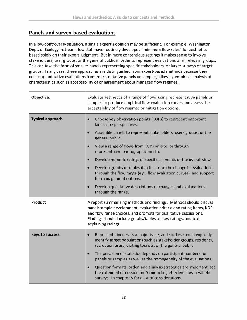
Flows and aesthetics: A guide to concepts and methods
28
Panels and survey-based evaluations In a low-controversy situation, a single expert’s opinion may be sufficient. For example, Washington Dept. of Ecology instream flow staff have routinely developed “minimum flow rules” for aesthetics based solely on their expert judgment. But in more contentious settings it makes sense to involve stakeholders, user groups, or the general public in order to represent evaluations of all relevant groups. This can take the form of smaller panels representing specific stakeholders, or larger surveys of target groups. In any case, these approaches are distinguished from expert-based methods because they collect quantitative evaluations from representative panels or samples, allowing empirical analysis of characteristics such as acceptability of or agreement about managed flow regimes.
Objective: Evaluate aesthetics of a range of flows using representative panels or samples to produce empirical flow evaluation curves and assess the acceptability of flow regimes or mitigation options.
Typical approach Choose key observation points (KOPs) to represent important landscape perspectives.
Assemble panels to represent stakeholders, users groups, or the general public.
View a range of flows from KOPs on-site, or through representative photographic media.
Develop numeric ratings of specific elements or the overall view.
Develop graphs or tables that illustrate the change in evaluations through the flow range (e.g., flow evaluation curves), and support for management options.
Develop qualitative descriptions of changes and explanations through the range.
Product A report summarizing methods and findings. Methods should discuss panel/sample development, evaluation criteria and rating items, KOP and flow range choices, and prompts for qualitative discussions. Findings should include graphs/tables of flow ratings, and text explaining ratings.
Keys to success Representativeness is a major issue, and studies should explicitly identify target populations such as stakeholder groups, residents, recreation users, visiting tourists, or the general public.
The precision of statistics depends on participant numbers for panels or samples as well as the homogeneity of the evaluations.
Question formats, order, and analysis strategies are important; see the extended discussion on “Conducting effective flow-aesthetic surveys” in chapter 8 for a list of considerations.

Flows and aesthetics: A guide to concepts and methods
29
Panelists should evaluate flows independently before focus group discussion to reduce the potential for “group effects.”
A good facilitator is critical to the success of post-evaluation focus groups and the collection of qualitative information.
Differences (within or between panels) require explanations. They do not necessarily mean only one group is correct or that lack of agreement precludes conclusions about findings. Different groups may have different judgments about acceptable aesthetics. The task is to understand those differences and reconcile them with protection or mitigation objectives for a given setting.
Example The Upper Spokane Falls study (CH2MHill, 2010) evolved from a settlement of litigation about 401 certification. The evaluation panel of 22 stakeholders represented the utility, state and federal agencies, non-governmental organizations, and consultants for various “sides” and the utility. Based on quantitative evaluations and focus groups, there was considerable agreement about aesthetic evaluations for different flows. Focus group discussions created transparency as ratings were explained.

Flows and aesthetics: A guide to concepts and methods
30
Hydrologic modeling and other desktop methods Several modeling-based approaches use summary hydrologic characteristics of a river (such as average annual flow or average minimum flow) to estimate flow needs. These methods were developed to protect water quality or ecological values, but they were more common in the early years of instream flow protection (before about 1990). Although they have substantial shortcomings, we have included them because they are still used in some states, are often referenced in histories of flow protection, and it is usually simple to consider such “rule-of-thumb” estimates before more intensive studies are conducted. 7 Q 10 method. This is a simplified hydrologic record method defined by the lowest seven-day average flow that occurs every ten years (a historically low flow for the period of record). It is an important flow from a water quality perspective, and is used to help set EPA Clean Water Act standards (e.g., pollutants cannot exceed certain concentrations during a given 7Q10 flow). In early instream flow protection schemes, several states (e.g., Georgia, Mississippi, and Alabama) allowed water withdrawals up to this easily-calculated minimum flow. More intensive fisheries work has shown this flow rarely protects the diversity of aquatic species and life stages. As the Instream Flow Council (2004) has noted, “making such a low flow the norm is like recommending the sickest day of your life as a satisfactory level for future well-being.” However, many dam-regulated rivers provide flows lower than the natural 7Q10 flow, and this natural historic low is at least a useful benchmark. These 7Q10 flows do not specifically reference recreation or aesthetic values, but there is some intuitive utility in identifying this hydrologic minimum. Tennant or Montana method. This instream flow protection technique was pioneered by fish biologist Don Tennant of the USFWS in the 1960s and 70s (Tenant 1973). In his travels around Montana, Wyoming, and Nebraska, Tennant systematically photographed river reaches at bridge crossings, assessed ecological health at that time, and later used gage data to calculate the percentage of mean annual flow shown in the photos. Sorting the photos into piles, he developed rule of thumb estimates for “good” (30% of mean annual flow) and “excellent to outstanding” (60%) fish habitat, and noted that flows about 10% of mean annual flow rarely covered more than half the river channel and provided only short-term survival habitat. He also claimed that the 30% and 60% estimates provide for “general recreation” and “the majority of recreation uses,” respectively. Like the 7Q10 method, additional work has shown the Tennant method oversimplifies the relationship between flows and ecological protection, and no work has closely examined Tennant estimates of aesthetic or recreation quality. However, refinements have improved the utility of Tennant ecological estimates by addressing different types of streams, aquatic species, and life stages. In addition, many recognize the value of using simple hydrology statistics as a starting point for estimating flow needs or identifying streams needing more vs. less attention. Variations on the Tennant Method for recreation. Adaptations of Tennant’s approach have been used to identify rule of thumb recreation flow needs. Corbett (1985) used professional judgments on several southern and mid-west rivers to develop relationships between minimum boatability in open canoes (“canoe-zero”) and mean annual flow, while researchers in South Carolina did the same for motorized jon boats on Piedmont streams. These efforts have shortcomings in their execution and focus (see Shelby and Jackson, 1991 and Whittaker et al., 1993 for details). But they show conceptual connections between hydrology, resource characteristics, and evaluations for specific purposes, and these may extend to flow-aesthetic evaluations. We expect to learn more as more intensive flow-aesthetic studies are completed.

Flows and aesthetics: A guide to concepts and methods
31
Objective Apply models using existing hydrology information to develop “rule-of-thumb” estimates of minimum or optimum flows for aesthetics.
Typical approach Formula-based models have not been developed, but variations of Tennant’s methods might show relationships between hydrology variables (e.g., mean annual flow) and aesthetic evaluations.
Initial aesthetic evaluations used to develop these relationships might use professional judgments through more rigorous methods described in this chapter.
Regression or similar statistical analyses might be used to fit a curve to the hydrology-evaluation relationship.
Resulting formulae might be applied to other rivers of similar types or with similar features. Like Tennant’s work, these are likely to be rule-of-thumb estimates that don’t replace more detailed studies.
Product Formula-based outputs that identify acceptable or optimal aesthetic flows from hydrology data.
Additional issues Little work has identified specific hydrologic variables that are related to aesthetic judgments. Mean annual flow (as used in Tennant and modified Tennant approaches) is one option, but other variables more closely related to channel size (e.g., median flow in the lowest-flow month) might be more useful.
Relationships between hydrology variables and aesthetic quality probably vary for different types of streams or aesthetic features.
Aesthetic-hydrology relationships may vary considerably for waterfalls of different types, and may need distinct formulae (similar to Corbett’s canoe-zero estimates, which varied for whitewater vs. flat water and different types of rivers).
Cautions and limitations This approach is unlikely to replace more intensive studies on complex rivers with higher levels of controversy. But it may eventually provide rule-of-thumb estimates in simple situations where aesthetic study resources are limited, or threats to aesthetic flows are minimal.

Flows and aesthetics: A guide to concepts and methods
32
5. Integrating aesthetics with other resource values
Aesthetics are typically one component of multi-faceted decision-making about managing flows in rivers, so it is important to consider how aesthetic studies are integrated with findings for other resources. The following adapts discussion from Whittaker et al. (2005). True integration is not always designed into hydropower licensing or instream flow protection programs. Many flow decision-making processes include centralized tracking of diverse studies. But this generally focuses on progress in terms of schedule and budgets rather than sharing findings, discussing implications across disciplinary boundaries, or considering implications for overall decision-making. It is possible to design specific cross-disciplinary sessions to explore how findings from one resource might fit with those from other areas. By encouraging cross-discipline terminology and comparable core data, earlier information-sharing provides opportunities for researchers to consider similar sets of outcomes. In an ideal world, each resource area has sufficient information about the effects of any flow regime; in reality, studies can address only a limited number of alternative scenarios. The challenge is developing relevant alternatives early in the process. Early discussion among work groups also encourages a less adversarial search for “elegant solutions” that provide for multiple resources, before positions become hardened. The sooner everyone learns about the range of potential proposals, the easier it is to design studies to address the issues and clarify advantages and disadvantages. Effective decision-making benefits from distinct roles among participants, where scientific information is developed by researchers who are not advocates. While utilities are responsible for collecting flow-aesthetic information or hiring consultants to conduct associated studies, it is important that all parties perceive those studies as unbiased. Utilities, agencies, or stakeholders then use that information to develop their interests, which may be competing or adversarial, before becoming “locked into” positions. It makes sense for utilities, agencies, and stakeholders to participate in the study process, and it is more difficult and expensive to address flaws discovered after studies are completed. In some situations, aesthetics are compatible with other resources. Flow regimes that provide for healthy fish, riparian ecology, and high quality recreation are likely to be aesthetic too. Conversely, flows for aesthetics (e.g., weekend high flows during spring run-off over the Snake River’s Shoshone Falls) are unlikely to adversely affect fish or recreation, and may provide dynamic higher flows (if only for short periods). But such assumptions should be treated as hypotheses for research, not simply presumed. Like some recreation flows for boating or fishing, aesthetic flows do not need to be available 24-7 or in all seasons to benefit visitors, so there may be creative ways to minimize lost power or avoid other impacts from a regulated flow regime. Studies that assess seasonal, day of week, and time of day preferences allow decision-makers to consider the tradeoffs. If aesthetic flows are provided on a short-term or irregular basis, there are creative opportunities to notify the public of their availability. USGS and National Weather Service gage information is often available in real-time, and other web-based tools such as webcams are feasible where there is power and telecommunication. The goal is to help the public experience aesthetic resources.

Flows and aesthetics: A guide to concepts and methods
33
6. Example flow-aesthetic studies and projects This chapter provides summaries of several flow-aesthetics studies or projects. Some are short and cover limited issues, while others offer more detailed information about the river, study, or how information was used. Collectively, they are designed to highlight interesting methods, concepts, findings, or applications of results to protect, mitigate, or enhance impacts from hydropower or other flow-changing projects. The examples are roughly ordered by the date of their earliest flow-aesthetic study or project.
Niagara Falls Niagara River between U.S. and Canada
Niagara Falls is the most famous falls in North America, visited by 15 million people per year. Dropping 160 to 190 feet (depending on the segment and flow), the falls has three named segments: American Falls (850 feet wide), Bridal Veil Falls (55 feet), and Horseshoe or Canadian Falls (2,200 feet).
More than half of the natural flow is diverted around the falls. Diversions for mills began in 1853, for power in 1877. Hydropower diversions increased in the early 1900s until firm limits were set in 1950. The U.S. hydropower project licensed by FERC at Niagara is P-2216.
Aesthetic concerns were evident to critics in the early 1900s. Geologists were commissioned to investigate “the recession of the falls” from erosion and “how far the falls could be diverted without bringing about unforeseen disasters” (Spencer, 1908). Spencer argued that “preservation of the falls is now a question of inches” and showed how small changes in stage from proposed diversions could dramatically reduce the crest line (Horseshoe Falls by about 40% and American Falls by half). He also showed that diversions from either the U.S. or Canadian side affected both falls (contrary to popular opinion) and suggested that economic benefits from tourism might outweigh those from power.
Niagara probably had the first flow-aesthetics study. Studying photos from several locations between 155,000 and 245,000 cfs, Jones reported low flow impacts for both American Falls (a “thinly covered” crest) and Horseshoe Falls (a “broken crest line and separated streams” and a shorter crest line overall), but that mist obscured the falls at higher flows. In summary, Jones asserted “the excess of river flow above 180,000 cfs contributes little or nothing to the scenic beauty of the Falls,” and such high flows may “add materially to its destructive erosion,” the rate of recession that was occurring at the time.
Water diverted from the falls has been regulated by international treaties since 1910, but the 1950 Niagara Treaty currently in place only requires 100,000 cfs over the falls during daylight hours in the tourist season (April 1 to September 15), and only 50,000 cfs at all other times. The excess can be used for hydroelectric power (equally spilt between the two countries). This is about half of the river’s natural flow (long-term hydrology suggest it averages 202,000 cfs per year, with peaks as high as 300,000 cfs). The most common amount tourists see is half the flow; in the evenings and winter, they see (or hear) about one quarter of the natural flow, both much less than Jones’ 180,000 cfs.

Flows and aesthetics: A guide to concepts and methods
34
A weir used to divert water for power further exposed the channel on the flanks of Horseshoe Falls and made it less aesthetic to visitors in 1953. Subsequent improvements more evenly distributed water to the American Falls side, and removed debris from the flanks of Horseshoe Falls while building up a viewing area that reduced the crest line by 330 feet. This is probably the first major example of channel modification to improve flow-related aesthetics in a river, and illustrates a recurring generalization: “cover the bottom of the channel to provide the greatest aesthetic benefit.” In combination with reduced flows, channel modifications have reduced the length of the falls’ crest line by about 750 feet since 1900. The current situation is a more compact but evenly distributed plume.
In 1968-69, all flow was diverted from the American Falls side to assess erosion rates and the feasibility of “cleaning up” the jumble of eroded rocks at the base of the falls. A public survey indicated that most people did not want the rocks removed, and the costs would far outweigh the benefits. But engineers decided that it was feasible and beneficial to shore-up the crest of the falls to reduce natural erosion rates.
The Niagara hydropower plants are about five miles downstream of the falls. When hydropower removes its maximum diversion, the elevation of the “Maid of the Mist” pool below the falls drops about 15 feet.
Hydropower generation, by removing a substantial proportion of flows over the falls, has reduced the level of erosion (currently under 1 foot per year). Even so, erosive changes in the river’s channel are likely to dry up American Falls in about 2,000 years without channel modifications (Niagara Parks, 2016).
In June 1971, a second flow-aesthetics demonstration study increased the flow over American Falls from 8,000 cfs to about 15,000 cfs (right). A report noted “there was no doubt that the increased flow…greatly enriched the appearance, deepening the green water plunging over the crest and adding considerably to the turbulence of whitewater pouring over talus rocks” (Niagara Falls Preservation and Enhancement Report, 1971).
The report recognized that “the beauty and the drama of the Falls depend upon the interplay and relative proportions of these [three] elements:” 1) the volume of water; 2) the “sculptural form of the talus and bedrock;” and 3) the water surface level and water’s edge of the downstream pool. Scientists considered removing talus to increase the height of the water fall, raising the downstream pool level to restore an earlier natural condition, or increasing the flow to create a deeper and more turbulent water course.
Engineers dried up the American Falls in 1969 to study erosion rates. Photo by Edwin H Schroeder.

Flows and aesthetics: A guide to concepts and methods
35
Scientists made a working model of the falls at a 1:50 scale, which created a falls about 22 feet wide and four feet high. To enhance the realism of the model, they used dry ice in the water to simulate blowing spray, and carefully illuminated the features for photographs at nine different levels of talus in the falls. But they couldn’t duplicate the water’s characteristics as well, especially opacity and level of aeration. A full set of photos were taken of each level, accompanied by narrative appraisals by experts (apparently landscape architects). In the end, the study decided not to remove any of the talus or change flows on the American side.
Kootenai Falls, Montana Kootenai River near Libby, Montana
This falls and associated cascades drop about 90 feet in less than a mile, with the largest drop about 30 feet high. The river is about 700 to 800 feet wide.
The falls is one of the largest free-flowing waterfalls in the northwest with an average annual flow of about 11,000 cfs, annual peaks about 50,000 cfs, and historical peaks over 120,000 cfs.
As described by Allen (1985) and Hooker (2014), a proposed hydropower project on the river was rejected by FERC in 1984 and affirmed in 1987 after hearings before an Administrative Law Judge (FERC, 1987). The project would have reduced late summer and fall flows in the falls to 750 cfs, “significantly reducing the amount of white water, changing and reducing the decibel level of the roar of the water, eliminating the spray, mist and rainbows permanently, exposing to view considerably more rock, eliminating the daily flow fluctuations, introducing man-made structures into an otherwise natural waterway, and, generally, making the falls less attractive to visitors.”
Higher flows about 14,000 cfs in July 2013 covers most of the falls, creates a mid-channel island, and shows greater spray and power.
Lower flows about 4,000 cfs in October 2007 cover much less of the falls and only the river right side of the channel.

Flows and aesthetics: A guide to concepts and methods
36
Saint Anthony Falls Mississippi River in Minneapolis, Minnesota
Saint Anthony Falls was the only natural waterfall on the Mississippi River, but partially collapsed from erosion in 1869. Recognizing that further erosion would eventually turn the 60+ foot falls into a rapid that could not be used for water power, engineers “capped” the falls with a concrete spillway in 1870 that was incorporated in several locks and dams in the 1950s and 60s.
With most of the water diverted into locks and penstocks for 10 months of the year, minimum flows passed over the spillway and algae growth reduced aesthetic quality of the dam face. A 1986 study explored whether “deflectors” attached to the spillway surface could create a “waterfall-like effect” and reduce algae growth.
Experiments with the deflectors (curved metal plates about 4 inches long) were assessed at 100, 200 and 300 cfs over the 34-foot tall x 100-foot wide spillway. Observers preferred deflectors in cluster patterns (rather than evenly spaced), and aesthetics were similar at all three flows. Concern about erosion due to cavitation from the deflectors led to their removal from steeper parts of the spillway. Base flows were ultimately set at 100 cfs (shown in photo above). Since 2003, NPS has advocated for minimum flows of 200 cfs, and local advocates (including the Minneapolis Park and Recreation Board), have recommend flows as high as 2,000 cfs.
There have been several complex plans to re-license hydropower on the river in recent years, including projects on both sides of the river. A Draft License Application was filed in fall 2016 for P-11175, with many comments about potential impacts. An aesthetic study of flows over the spillway (in response to an additional information request) was recently completed (Excel, 2016).
The study asked respondents to rate seven flows from 100 to 2,000 cfs from three KOPs; the photos were arranged on a poster board (see right for an example from one KOP). Response options were on a four-point scale: unacceptable, marginal, acceptable, and optimum.
The highest flow (2,000 cfs) was rated the highest, with 56% rating it the optimum flow, and another 27% reporting it acceptable.
Majorities rated all the flows from 300 to 2,000 cfs either acceptable or optimum, and differences between 300 and 1,000 cfs were small. The uniform surface of the dam spillway may minimize differences in aesthetics through this range.
At the low end of the flow range, 100 cfs (see photo at top of the page) was unacceptable for 41% and marginal for 15%. This flow did not produce as much whitewater, and had more algae visible.

Flows and aesthetics: A guide to concepts and methods
37
Bond Falls Ontonagon River near Ironwood, Michigan
Bond Falls (50 feet, shown at 110 cfs) and Agate Falls (40 feet) are located on the Middle Branch of the Ontonagon River in Michigan’s Upper Peninsula. Created by terraced sandstone, they are two of Michigan’s most scenic falls.
The Bond Falls Hydropower Project (P-1864) was built in 1952 and its initial license expired in 1988. Dam safety issues, designations in the National Wild and Scenic River System, additional studies, and settlement discussions delayed the new license until 2003.
Minimal aesthetic studies videotaped flows in both falls at 40, 55, and 180 cfs, but did not make evaluations.
Documentation of flows in Bond Falls included a decibel meter in the foreground quantifying sound, although the video did not record actual sound. Viewers were left to imagine the sound based on the decibel levels shown on the meter.
Minimum flows were established at 80 to 110 cfs in different months, primarily for fisheries (Fedora, 2004). Typical natural flows were about 400 in spring and 150 during low flow periods. The license limits diversions to 175 cfs, which was less than the project had traditionally removed in order to maintain springtime flows and provide for channel maintenance.
Superior Falls Montreal River on the Michigan/Wisconsin border
Superior Falls is a series of drops in Montreal Canyon near the outlet of the Montreal River, which forms the border between Wisconsin and Michigan. The entire falls is over 100 feet tall, while the largest drop is 60-foot Lower Falls (shown at about 180 cfs).
Two hydropower projects (Superior Falls P-2587 and Saxon Falls P-2610) remove most of the water in summer and fall, but in spring or after rainstorms, flows range from 500 to 2,000 cfs.
Aesthetic flows were documented during relicensing studies in 1991; they included video of 7, 35, and 50 cfs, but did not make aesthetic evaluations. The license set minimum flows at 20 cfs.
Current licenses that affect flows in this canyon expire in 2019 (Saxon Falls) and 2024 (Superior Falls). NPS has urged FERC to relicense both together on the 2019 timeline given interest in whitewater boating and re-consideration of aesthetic flows.

Flows and aesthetics: A guide to concepts and methods
38
Yantic Falls Yantic River, Connecticut
As described in Hooker (2014), Yantic Falls are natural and human-built falls on the 15-mile Yantic River in Connecticut. The Upper Falls flows over a 15 foot dam; the Lower Falls drops about 55 feet over natural obstacles in a 100-yard gorge. The falls are a major attraction in the city of Norwich (population 40,000).
The gorge is an historic site where a Native American tribal leader made a great “Indian Leap” to escape a pursuing tribe.
An historical hydroelectric project had lapsed, but a new utility applied to redevelop it in the early 1990s. The proposed Project (P-7334) would have reduced “intermediate flows” in winter and spring (usually 60 to 100 cfs) to 20 cfs. FERC initially approved the license with aesthetic flows of 100 cfs on weekends and holidays.
During a requested rehearing, the City of Norwich argued that the small amount of power provided by the project (about one megawatt) did not justify the loss of aesthetics provided by the falls. Aesthetic features included the falls’ visual, auditory, and sensual values, as well as recognition of the river’s winter ice formations and summer mist-based rainbows at higher flows, which attracted visitors throughout the day, week, and year because of the location near the center of town. Project critics also showed that the utility’s aesthetics study failed to document preferred flows or show visitation was limited to weekends and holidays.
FERC reversed its decision by acknowledging Norwich’s claims and further arguing that this was “one of the prime waterfall gorge combinations in the state” that had received recreation facility grants from the National Park Service, the State, and private donors (FERC, 1992).
The case implicitly recognizes that an aesthetic feature (Upper Falls) was produced by water flowing over the human-built dam (similar to the Enloe Dam falls on Washington’s Similkameen River, described below).
Upper Yantic Falls at approximately 20 cfs, 90 cfs, and 250 cfs.

Flows and aesthetics: A guide to concepts and methods
39
Snoqualmie Falls Snoqualmie River, Washington
Snoqualmie Falls is 268 feet high and one of the most famous falls in the Pacific Northwest, with over 1.5 million people visiting per year.
The river naturally averages 2,000 to 4,000 cfs most of the year, with flows under 1,000 cfs in summer and early fall. Annual peaks are typically 15,000 to 40,000 cfs, although flows have occasionally exceeded 60,000 cfs.
The Snoqualmie Falls Hydropower Project (P- 2493), the world’s first underground plant, was built in 1899, and expanded in 1919 and 1957. The current 54 megawatt project can divert 2,700 cfs through two power plants.
A Puget Sound study in 1991 considered sound, mist, and visual evaluations of the falls at different flows, documented with still photos and video at 25, 100, 200, 450, 1,000, 1,450, 3,350 and 11,200 cfs.
The study suggested that sound changes between 100 and 450 cfs were about 3 db and “barely perceptible.” In contrast, spray increased from “light” levels at 100 cfs to “moderate” at 200 and 300 cfs, and “heavy” at 1,000 cfs and higher.
The study documented changes in the waterfall’s form, with a single thin plume at 25 cfs, two plumes at 100 cfs, four plumes at 450 cfs, five plumes at 1,000 cfs, and six at 3,350 cfs. The plumes merge into a larger block falls at higher flows.
The study did not include a public preference survey, although Washington Department of Ecology asked public meeting attendees to rank photos from the study, and the EIS described higher rankings for higher flows.
A new FERC license in 2004 included minimum day time aesthetic flows from 100 to 450 cfs in different lower-flow times, with as little as 25 cfs during some night times. In general, higher flows were required for weekends and in summer high-visitation periods.
The Snoqualmie Indian Tribe considers the falls a sacred site and asked FERC to increase flows, noting that higher natural flows create mist and spray that are central to the practice of their religion. FERC revised the license to require 1,000 cfs 24 hours per day during May and June, arguing this would provide greater mist and spray to meet the Tribe’s spiritual requirements, along with general aesthetics benefits. The Tribe filed suit to get higher flows more often, but FERC eventually prevailed in the 9th Circuit Court (Snoqualmie Tribe vs. FERC, 2008).
Snoqualmie Falls at 1,200 cfs (left) and 11,000 cfs (right) before
and after a major storm in fall 2016.

Flows and aesthetics: A guide to concepts and methods
40
Virgin River BLM-managed segments in Utah, Arizona, and Nevada
The Virgin River, with headwaters near Zion National Park, flows for 150 miles through Utah, Arizona, and Nevada into Lake Mead near Las Vegas.
BLM studied flow needs for recreation and aesthetics as part of a state water rights claim in the early 1990s.
Aesthetic video footage was collected at eight KOPs on 14 days through a season’s natural flow range in 1993. Sites with channel and water visible were chosen based on access, visitation levels, aesthetic quality, and repeatability of data collection. At each KOP, video (including sound) was taken for one minute per flow. For evaluations, footage was edited into 10-second segments, with the order of flows randomized for each location.
The study surveyed a total of 104 people in two samples, an Oregon State University forestry class (n=59) and BLM staff (n=45). They received an introduction about aesthetics and a description of the river, then evaluated river scenes using a seven-point acceptable-unacceptable scale at flows of 18, 81, 236, 697, 770, 894, 1,510 and 1,930 cfs (although not all flows were available for all KOPs).
Findings show high ratings at all but the lowest flow (see flow evaluation curves for two KOPs, right). After the channel was covered (about 80 cfs), higher flows did not improve ratings. This was an early example of a finding that has since been seen in other places and is offered as a principle of flow-aesthetic studies (see Chapter 9).
Findings also show differences between ratings at pools and rapids. Both improve rapidly as the channel is covered, but rapids receive slightly higher ratings at medium flows as water movement and turbulence add to aesthetic quality.
Ratings from a clear water tributary (North Creek) were a little higher than ratings of the main stem through the entire range, suggesting that turbidity may play a part.
The study recommended relatively low minimum aesthetic flows designed to ensure water covers the bottom of the channel at e4ach location.
Virgin River Gorge south of St. George, Utah, at 160 cfs.

Flows and aesthetics: A guide to concepts and methods
41
Barberville Falls Poesten Kill, New York
Barberville Falls is a 90-foot waterfall over slate and limestone outcroppings on the Poesten Kill, east of Albany, New York. Average flows range from 15 to 90 cfs in different months, with higher peaks.
A utility proposed a 335 kw hydro project that would divert all but 15 cfs year-round. It did not conduct a flow-aesthetics study.
The nearby town of Poestenkill, the Rensselaer County Environmental Council, and other non-governmental environmental organizations argued the falls were important to the identity of the village and a significant regional recreation attraction requiring higher flows that naturally vary through the year.
FERC agreed by rejecting the utility’s proposal, stating the reduction in “quality, duration, and variability of flow would affect the visual and auditory character of the falls and would degrade the quality of the vibrations generated by the naturally cascading waterfall and the mist and ice formations” (FERC, 1995).
Barberville Falls at low fall flows (about 50 cfs) and higher winter flows (over 150 cfs).

Flows and aesthetics: A guide to concepts and methods
42
Shoshone Falls Snake River near Twin Falls, Idaho
Shoshone Falls on Idaho’s Snake River is 212 feet high and 950 feet wide. It has been called the “Niagara of the West.”
A tourist attraction as early as the 1860s, irrigation and hydropower development in the early 1900s reduced total river volume by about two-thirds, leaving the falls dry during low flow periods.
Base flows after irrigation withdrawals range from about 6,000 in spring to 1,000 cfs in late summer, with runoff peaks about 20,000 cfs and record high flows about 32,000 cfs (about 10% of Niagara Falls’ peak).
There are four distinct segments at lower flows (upper right) and a block falls at higher flows (lower right).
Idaho Power’s project removes up to 950 cfs. Studies during relicensing (Idaho Power, 1996) documented aesthetics with a national sample evaluating color photos of the falls at 50, 250, 578, and 2,660 cfs using a 10-point scenic beauty scale. The study also showed the percent of channel covered from 50 to 1,200 cfs. Results are given in the figure below.
Stakeholders requested summer flows of 750 to 1,200 cfs, while the utility recommended 300 cfs. FERC required 300 cfs during daylight hours from April through Labor Day (9 am to 8 pm).
In 2006, Idaho Power asked FERC to increase maximum diversions from 950 to 4,800 cfs, while offering to keep aesthetic flows of 300 cfs with higher flows on holiday weekends. In 2010, discussions with local, state, and federal agencies led to a more complex regime provided higher aesthetic flows more often.
Ultimately, Idaho Power plans a more modest diversion increase of 1,050 cfs rather than 4,800 cfs. Stakeholders and FERC are considering the impacts of this proposal in spring 2017.

Flows and aesthetics: A guide to concepts and methods
43
Tallulah Gorge Tallulah River, Georgia
Tallulah Gorge is about two miles long and nearly 1,000 feet deep. Six drops collectively known as Tallulah Falls plummet 490 total feet in a mile. The gorge is a major tourist attraction, viewable from several trails and overlooks.
Railroad access and resort hotels were developed in the late 1800s to serve tourists visiting the “Niagara of the South,” but a 1913 hydroelectric project removed most of the water from the river and tourism declined. Natural flows would be about 350 cfs in dry times of year and up to 900 cfs in spring or after storms. Typical post-dam flows were 0 to 15 cfs, except after substantial rains.
The hydro project (P-2354) was relicensed in the mid-1990s, and aesthetic flows were a major issue. The utility documented aesthetics in the gorge at 35, 75, 100, 200, and 300 cfs from five KOPs (on the rim and in the gorge). FERC staff also reviewed aesthetics at three boating flow releases (400, 600, and 800 cfs). The aesthetics study did not develop numeric ratings, but provided qualitative descriptions of attributes, including visibility of river from the rim, apparent volume of water, width of river, exposed rock in riverbed, auditory effects, and presence of spray.
Findings suggested that the lowest flows (35 and 75 cfs) produced minimal sound or spray, and the largest falls (Hurricane) has a single plume at 35 cfs but two at 75 cfs. Flows greater than 100 cfs begin to create falls that are more “significant features in the gorge…, with visible plunge pools and spray,” and greater coverage of the bedrock channel (FERC, 1996). Most of the falls cover the full width of the channel by 200 cfs, and attributes like spray become more noticeable. Flows at 200 and 300 cfs also appear more “dense” and covered most of the larger boulders in the channel, but flows from 400 to 800 cfs are needed to produce “explosive, powerful…and turbulent” rapids. Higher flows reduce some aesthetic features as “some rocks are drowned” and there is a “loss of contrast between riffles and pools.”
The final license requires releases of 35 to 50 cfs base flows, with 200 cfs “aesthetic releases” during daylight hours on 18 weekend days and 9 weekdays in the spring and fall. There are 10 days of higher flows for whitewater boating and aesthetics on weekends in April and November. Georgia DNR estimates the gorge now attracts 300,000 to 600,000 visitors per year.

Flows and aesthetics: A guide to concepts and methods
44
Shepaug River Washington and Roxbury, Connecticut
The Shepaug is a 26-mile tributary of the Housatonic River in Northwest Connecticut, popular for hiking, swimming, angling, and canoeing. Public access occurs at road crossings, parks, and on large properties managed by two land trusts.
Mean annual flow is 236 cfs, with spring peaks from 500 to 800 cfs, and summer low flows of 10 to 50 cfs.
The City of Waterbury (about 25 miles away), had a 1921 contract to divert up to 20 cfs for domestic and industrial uses when other water supplies were inadequate.
By the mid-1990s, land trust users and residents objected to the increasing frequency of low summer flows. They argued that Waterbury’s diversions diminished the river’s natural beauty, harmed habitat, and decreased the quality of recreation resources, all values protected by the 1971 Connecticut Environmental Protection Act (CEPA). The ensuing controversy led to litigation, focusing on whether the river was “unreasonably impaired” and whether Waterbury was taking more water than the 1921 contract allowed. A trial in Connecticut Superior Court occurred in 1999-2000.
Research conducted for litigation included a review of resource documents, interviews with recreation users, and fieldwork at flows of 10, 60, and 250 cfs. Findings examined effects on boating, fishing, and swimming, and photography documented changes in aesthetics at several sites. At pool and glide locations, flows as low as 10 cfs fill the bottom of the channel, so diversions would not substantially diminish aesthetics. In shallower riffles and a few rapids locations, small flow reductions had substantial effects on the width of the covered channel, and therefore diminished aesthetics.
The judge ruled for the plaintiffs in favor of higher flows for aesthetics, noting the choices were between public interest “in the natural condition of a beautiful and nearly pristine river” and “an abundant and low cost supply of potable water.” She ordered Waterbury to reduce its diversions due to “substantial diminishment” of several resources, including aesthetics. In support of her decision, she referenced expert studies (Shelby and Whittaker, 1999) that showed how the “width of the wet portion of the river” is the primary issue, and that lower flows due to Waterbury’s diversions “…appreciably diminish…the appearance of the river.”
Waterbury appealed the decision to the State Supreme Court, which ruled on several issues and sent it back to the lower court for a new trial. With the cost and uncertainty of that trial looming, the two sides settled in 2006. Waterbury agreed to provide minimum flows (at 19 cfs), contingent on state funding for water system improvements. Over 3.5 million in State funds were applied to implement the agreement in 2008, and higher summer flows have occurred since 2009. A more detailed review of the case and its implications is in Whittaker and Shelby, 2010.
Shepaug River near Roxbury, Connecticut about 90 cfs.

Flows and aesthetics: A guide to concepts and methods
45
Spokane Falls Spokane, Washington
The Spokane River is a major feature in the middle of Spokane, Washington. The river drops over two falls (60 feet total) and other cascades through a half mile-long park in the heart of the city.
Historians have chronicled the city’s growth in relation to the river, which provided fish resources, hydropower, recreation, and scenic quality (Olmstead and Olmstead, 1913; Young, 1996; Stratton 2005).
The downtown river park was the site of the first environmentally-themed World’s Fair in 1974. About 2.5 million visit the area each year (Avista, 2004).
The river’s natural flows range from 2,000 to 10,000 cfs in winter and spring, but drop as low as 800 to 1,000 cfs in summer and early fall. Peak flows in late spring are typically 15,000 to 35,000 cfs, occasionally exceeding 45,000 cfs.
A private utility (Avista) operates several hydroelectric projects on the river (under one license, P-2545). Prior to 2009, hydropower diversions removed up to 2,500 cfs from the falls, dewatering the falls except for “leakage” flows (about 30 cfs) during low flow periods. Stakeholders were interested in higher minimum flows for aesthetics in the 2009 license.
An Upper Falls flow-aesthetic study (Berger 2003) used a focus group to rank video of flows at about 30, 100, 200, 300, 400, and 500 cfs through the short bypass reach. Results showed the highest rankings for the highest flows, but recommended 200 cfs as the minimum flow.
A review of this study (Whittaker and Shelby, 2007) suggested several methodological shortcomings, including ranking rather than Likert-scale acceptability ratings, lack of representation of user groups among the evaluators, and selective use of qualitative information to justify the lower minimum flow recommendation. The initial study did not investigate flows higher than 500 cfs, even though natural flows range from 2,000 to 8,000 much of the winter and spring (and 2,500 cfs diversions could affect them).
After the FERC license adopted the utility’s proposed 200 cfs minimum in the Upper Falls, environmental groups litigated to reverse a concurrent 401 Water Quality certification by the state Department of Ecology. Following settlement talks, a second Upper Falls flow-aesthetic study (CH2MHill, 2010) was developed as a cooperative project between the utility, environmental groups, and their consultants. It focused on low flows of 300 to 500 cfs, but also analyzed whether channel modifications could improve aesthetics by redistributing water concentrated in human-made ditches.
A panel representing diverse stakeholders (n=22) evaluated flows and channel modifications on-site in July 2010, along with still photos of higher flows taken in spring 2010. Flows were manipulated using the diversion dam, channel modifications were manipulated with temporary sandbag weirs,
The largest drop in the South Channel of the Upper Spokane falls in downtown Spokane at 500 cfs.

Flows and aesthetics: A guide to concepts and methods
46
and evaluations were made with a quantitative survey from 10 key observation points. Follow-up focus group discussions provided qualitative information.
Results showed that 320 cfs flows with channel modifications were aesthetically similar to 500 cfs without modifications, confirming the principle that “covering the bottom of the channel” is a major objective for improving aesthetics. Data also showed that 1,000 cfs (the highest flow evaluated) produced even higher ratings.
Avista, state agencies, and environmental groups agreed to channel modifications in an amendment to the FERC license. The channel restoration project occurred in 2012, including several concrete weirs resembling the color and texture of natural bedrock. The weirs distributed water more evenly across the bottom of the channel, and new lower minimums of 300 cfs provide better aesthetics than 500 cfs with no modifications. Informal surveys suggest few visitors were able to identify the channel modification weirs (Avista, 2013).
Flow evaluations in Spokane Falls from photos; example photos show 400 cfs (top) and 30 cfs (bottom) in the roughly 105 foot wide South Channel.

Flows and aesthetics: A guide to concepts and methods
47
Middle Spokane River Spokane, Washington
Downstream of Spokane Falls, the river cuts through a 12 mile gorge with additional rapids, pools, and parks. In 2015, the Washington Department of Ecology adopted minimum instream flows for fisheries, recreation, and aesthetics (1,700 cfs October through March; 6,500 cfs April through mid-June; and 850 cfs mid-June through September). As of February 2017, environmental groups have appealed to have these minimum flows increased for fish, recreation, and aesthetics.
Stakeholders assembled a flow-aesthetics database of photos for 37 KOPs at a range of flows in 2014-2015. Although no quantified analysis has been conducted, a review (Whittaker and Shelby, 2015) suggests they illustrate two flow-aesthetic principles:
1. Changes in flow are more noticeable at sites with steeper gradients and boulders, and in shallow reaches with gravel bars or riffles. This is less true in pools or glides.
2. Flows that cover the bottom of the channel are likely to be more acceptable than those which expose channel features or a “bathtub ring.”
The report concluded that the Dept. of Ecology’s recommendation of 850 cfs in mid-to late-summer is near historic low flows, and public comments suggest this is lower than user preferences. Quantitative analysis could address these issues.
Four flows in Bowl and Pitcher rapid on the Spokane River. Photos of different flows were systematically collected at 37 locations along the river.

Flows and aesthetics: A guide to concepts and methods
48
Similkameen Falls Similkameen River near Oroville, WA
The 122-mile Similkameen River runs south through British Columbia, crossing into the United States for 25 miles, before joining the Okanogan River, a tributary to the Columbia.
Mean annual flow is 2,300 cfs, but runoff from March to June averages 8,000 cfs and peaks between 15,000 and 30,000 cfs. Late summer to early winter flows are 500 to 1,000 cfs.
Enloe Dam was built about nine miles above the Okanogan. The dam diverted up to 1,000 cfs into a 3 megawatt powerhouse from 1922 to 1958. But for the last 58 years, the entire flow of the river has passed over the 54-foot Dam Falls and the natural 20-foot Similkameen Falls downstream.
Public Utility District No. 1 of Okanogan County (the District) proposed a new hydroelectric project to divert up to 1,600 cfs to a new 9 megawatt powerhouse. This would reduce flows over both Dam Falls and Similkameen Falls to 10 or 30 cfs for about 8.5 months per year. The natural median flow over the two falls in the lowest flow month (September) is 506 cfs.
The District filed a draft FERC license application for this new project in 2008. Its proposed operations plan did not include aesthetic flows or a discussion of aesthetic impacts, prompting NPS, BLM, and state agencies to request additional information about the issue. However, the District argued against the need for these studies and FERC did not require them. By 2012, settlement discussions between the District and State agencies focused on flows for fish rather than aesthetics, and by the end of the year the State had agreed to a proposed flow regime without aesthetic flows and granted the District a 401 Water Quality Certification.
Several environmental groups filed litigation to block 401 certification, citing failure to adequately assess flow options for recreation and aesthetics. The trial-like hearing before a three judge panel representing the State of Washington Pollution Control Hearing Board (the Board) was held in April 2013.
For the trial, aesthetic experts were asked to assess whether the District or Ecology developed sufficient information to justify the proposed Project’s aesthetic flow regime under Washington’s water certification guidelines, to suggest other information or studies that could have helped with aesthetic or recreation flow decision-making, and determine if the District’s minimum flow proposal would provide “reasonable assurance” that recreation and aesthetic values were protected.
The plaintiffs’ expert witness report contained several aesthetic findings that were accepted by the court in its ruling, including:
o Flows over the dam have produced a 54-foot tall by 280-foot wide “visually impressive ‘block falls’ that generates considerable sound and mist at higher flows.”
The Similakmeen River flows over a 54 foot dam and 20 foot natual falls at about 700 cfs. A proposed hydro project would reduce flows to 10 to 30 cfs.

Flows and aesthetics: A guide to concepts and methods
49
o The proposed 10/30 cfs minimum flows would eliminate the Dam Falls and “reduce Similkameen Falls to a relative trickle, 6% or less of median dry season flows,” although it would have few aesthetic effects in the pool between the two falls.
o Both falls enhance recreation opportunities in the area, which had higher use than the District or Ecology acknowledged. Recreation investment in the region and specific recreation infrastructure in the area would induce greater recreation use.
o The District did not conduct sufficient aesthetic studies. They did not assemble photos of the falls through a range of flows, conduct direct evaluations of actual or simulated conditions, or produce a flow evaluation curve. Their modeling of proposed minimum flows was rudimentary and was not relied on by the Dept. of Ecology (which never saw it). The only District work on aesthetics produced simulations of proposed project infrastructure, which included factually incorrect depictions of flows in the spillway.
o Based on photos and simulations of different flows (developed from several sources), it was possible to develop an expert judgment curve for both falls; the District or Dept. of Ecology could have had panels of stakeholders or the general public conduct similar evaluations.
o Expert judgment curves (shown below) suggest 10 to 30 cfs flows were rated unacceptable for both falls, because they would cover only a small proportion of the bottom of the channel, provide little depth or power, and were unlikely to produce much sound or mist.
o For the Dam Falls, evaluations improve substantially through 240 cfs, where a 2006 photo shows good coverage across the entire dam and some power in the falls. Above this point, the Dam Falls does not improve as dramatically through 700 cfs (the highest flow observed during fieldwork).
o For Similkameen Falls, flows are concentrated in deeper channels and it takes more water to cover horseshoe-shaped brink. The curve shows that flows over the Falls become marginally acceptable at 350 cfs, and moderately acceptable at 450 cfs.
The panel of judges ruled in August 2013 that aesthetic values are a “designated and beneficial use,” both falls were aesthetic features, the District had not conducted adequate aesthetic studies, and there was little evidence that the 10 – 30 cfs regime would protect aesthetics. They also recognized the District’s complaint about challenges conducting a study before the project is built (because natural flows rarely drop below 300 cfs).
Without sufficient evidence to define minimum aesthetics flows (and assess complicated impacts on fish), the Board affirmed the state’s 401 certification, but required the District to study aesthetics of the 10 / 30 cfs regime within three years of the project’s construction. This would then be used by the Dept. of Ecology to set new minimum flows. The Board did not prescribe specific study
Expert judgment flow evaluation curves for Dam Falls and Similkameen Falls based on photos and simulations.
Similkameen Falls
Dam Falls

Flows and aesthetics: A guide to concepts and methods
50
methods, but suggested that it could assess actual or simulated flows and use focus group evaluations.
The concept of a post-licensing study, as ruled in this case, is unusual and illustrates the importance of conducting flow-aesthetic studies earlier in the licensing process. Studies conducted only after the project is built may constrain the ability to provide aesthetic flows, or have impacts on other resources that cannot be mitigated. In this case, study findings are likely to suggest increased post-project low flows, which could further affect the project’s overall economics. This possibility has led the District to hold meetings with agencies, stakeholders, and Tribes about abandoning the proposed project and removing the dam. However, liability and polluted sediment behind the dam are major impediments, and as of February 2017, the District still planned to construct the project.

Flows and aesthetics: A guide to concepts and methods
51
7. Background, evaluation approaches, and classification schemes The following discussions cover several supplemental topics that are important but tangential to the specific methods and concepts discussed earlier in this guide.
Distinguishing aesthetics and recreation
Descriptive vs. evaluative information
The philosophical roots of aesthetics
Visual Resource Management (VRM) approaches
Types of waterfalls and subjective waterfall evaluations
Distinguishing aesthetics and recreation Recreation and aesthetics are closely related concepts. People recreate outdoors to obtain psychological benefits that may include “being in nature” and “appreciating the beauty of nature.” These require settings with attractive natural features, or high quality aesthetics. For some people viewing scenery is recreation, while for others something like “scenic driving” or “scenic rafting” combines aesthetics with other activities. Aesthetics and recreation are sometimes juxtaposed in place names (e.g., Opal Creek Scenic Recreation Area); in language for protected area laws (e.g., the Wild and Scenic Rivers Act); and in research objectives (e.g., economic studies assessing recreation and aesthetic values of a park). In this guide, recreation is a broader construct. Recreation encompasses the activities people do, as well as people’s thoughts about those activities and the settings where they occur (e.g. their motivations, attitudes, and evaluations). In contrast, aesthetics are more narrowly focused on some of the physical attributes of the recreation setting, and people’s evaluations of those attributes. Both recreation experiences and aesthetic experiences are intangible, sometimes labeled “amenities,” and they are often measured by preference, acceptability, or quality scales rather than quantity or monetary scales. In recent decades, social scientists increasingly recognize complex hierarchies of human needs (e.g., Maslow, 1943; Rokeach, 1973), and recreation, aesthetics, and related values are considered central components of human life. The fields of recreation management and leisure studies are applied disciplines within the social sciences. These fields have helped describe, evaluate, and improve recreation or aesthetic experiences for individuals and communities. They offer terminology, theoretical frameworks, and methods that organize and measure concepts such as values, value orientations, attitudes, norms, and behavior in recreation settings. Work in these disciplines also shows how resource management actions such as education programs, regulations, or facility development affect conditions, behaviors, or evaluations, creating opportunities for high quality recreation and aesthetic experiences.

Flows and aesthetics: A guide to concepts and methods
52
Descriptive vs. evaluative information Considerable work has focused on how the amount and type of recreation use affects social conditions (e.g., crowding, carrying capacity, and conflict). Much of that work is based on well-established social research on values, attitudes, and norms (Manning, 2011; Shelby et al, 1996; Vaske, 2008), and it has been applied to environmental conditions such as forest practices, recreation site impacts, or flows. This research tradition distinguishes between descriptive and evaluative components (Shelby and Heberlein, 1986). The descriptive component focuses on how management actions affect conditions (e.g., how a diversion changes flows in a river) and related attributes (e.g., channel widths, depths, or the number of plumes in a waterfall). The evaluative component focuses on specific characteristics of attributes, which attributes matter more, and preferences for different flows. This work often involves focus group or survey research, where individual evaluations are quantified and can be analyzed for different groups (e.g., statistics can describe the range of acceptable conditions, levels of agreement, or differences between groups). The same research concepts and methods can be applied to aesthetics in recreation settings. The framework recognizes that most challenging resource decisions include value judgments. For example, evaluative standards (a defined level of acceptable impact) may differ for different rivers – a heavily-regulated urban river may be managed for minimally-acceptable aesthetics, while a more remote river with “outstandingly remarkable” scenery may be managed for higher quality conditions. Chapter 3 includes examples of different decision settings and associated aesthetic standards. Considerable research suggests there are curvilinear relationships between recreation/aesthetic quality and flow, with lower flows rated less acceptable (Whittaker et al., 1993; Whittaker and Shelby, 2002). Many studies produce flow evaluation curves (see example below), based on quantitative data or professional judgments (Whittaker et al., 1993; Whittaker et al., 2005). Chapter 4 reviews several methods that can be used to develop flow evaluation curves, while Chapter 7 provides several examples.
Example of a flow evaluation curve for the South Channel in Upper Spokane Falls. The curve is based on average ratings of six photos from 30 to 1,800 cfs.

Flows and aesthetics: A guide to concepts and methods
53
The philosophical roots of aesthetics
Humans have complex relationships with nature. Traditionally seen as a source of food, shelter, and commodities, natural areas also have spiritual values, and in the past 150 years have been recognized as important settings for recreation and aesthetic appreciation (Parsons, 2008). The topic of aesthetics has been studied within many disciplines, including art history, geography, sociology, and psychology, but it is particularly prominent in philosophy, which has long focused on defining beauty in art and nature. It is beyond the scope of this guide to review the entire literature on aesthetics, but several concepts provide context for this guide.
Aesthetics is a branch of philosophy focused on the appreciation of art and beauty. The term has Greek roots that translate to "I perceive” or “I sense,” and modern use dates back to German philosophers in the mid-1700s.
Among philosophers, aesthetic judgments focus on what is beautiful vs. ugly, transcendent vs. inferior, remarkable vs. mediocre, or acceptable vs. unacceptable. The idea is to systematically assess aesthetic qualities based on recognizable dimensions. More recently, social scientists operationalize these concepts by having people rate objects on scales with descriptive labels.
Aesthetic judgments initially considered art and architecture rather than nature, and pre-1700s art-based aesthetic principles tended to focus on proportion and symmetry. During that era, formal gardens were the only setting where natural elements received aesthetic consideration, and people generally did not tour natural areas or contemplate aesthetics in nature.
Aesthetic conceptualizations began to change in European culture in the 18th century as part of Enlightenment-era trends, including increasing access to wild areas (e.g., the Alps), the growing popularity of landscape painting, and scientific advances revealing the complexities of nature.
Moving beyond the classical focus on beauty defined by symmetry and proportion, philosophers identified other aesthetic concepts in nature, including the “sublime” and “picturesque.” Burke (1757) distinguished characteristics of beauty such as smoothness, smallness, lightness, and delicacy, from the sublime, which he associated with vast, rugged, massive, and potentially dangerous features. Others defined the picturesque in terms of textures and arrangements of features, especially when irregularities, unexpected contrasts, or partially concealed features invite curiosity (Gilpin, 1782; Price, 1796). Particular settings possess one or more of these aesthetic qualities, encouraging aestheticians to extend their judgments to more dynamic natural scenes.
Aestheticians have debated whether aesthetic judgments are objective (true for all) vs. subjective (individual to a person). Kant (1790) argued that beauty is objective and universal, and could be distinguished from “taste” that is subjective and varies according to class and culture.
Considerable work suggests that some aesthetic principles appear stable across cultures and time periods, although others clearly vary. Dutton (2009) offered a modern theory for “universal signatures” in aesthetics based on evolutionary origins. Noting ubiquitous cross-cultural interest in idealized “postcard” landscapes that mimic environments where humans first developed (e.g., open savannahs with low grasses, broad trees, evidence of water, indications of animal life, and paths that extend into distance, beckoning exploration), he concluded that aesthetic judgments are deeply held echoes of the environments and tools that humans needed for survival.

Flows and aesthetics: A guide to concepts and methods
54
Some philosophers (e.g., Burke and Hogarth) suggest that natural beauty can be reduced to lists of attributes. Others (e.g., Mill and Spencer) suggest that aesthetics should be linked to broader contexts in developing fields of biology and psychology.
Philosophers debate whether aesthetics should reflect an understanding of the process that created the landscape. For example, does knowledge of geologic history enhance appreciation for the beauty of the canyon or the river running through it? Dewey (1934) suggests that understanding can bring value to the viewing experience, while others argue that the experience of seeing an object, not understanding the process of making it, is the aesthetic phenomenon.
Functionalists argue that context matters, and aesthetics cannot be divorced from larger natural or human processes occurring in the landscape. They view aesthetic evaluation as a cognitive process that engages the intellect, not just sensory or emotional responses to a scene or piece of art.
Some philosophers suggest aesthetic appreciation may follow from economic, political, or moral values (e.g., some may appreciate a golf course in a desert because it implies human mastery over nature, while others may be offended at the scale of consumption). Saito (2009) argues that such intellectual considerations (embedded in one’s beliefs and attitudes) are integral to understanding modern aesthetic evaluations.
The discipline of environmental aesthetics arose in the late 1900s as a reaction to the over-application of art-based judgments to nature appreciation. The scope of this field is wider than just natural settings; it has included the “aesthetics of ordinary life,” or how humans arrange daily tasks and environments to accentuate beautiful features.
Saito (1998) argues that information about a scene or object can be central to aesthetics. This is a partial rejection of the importance of “picturesque” scenes, suggesting appreciation of a mountain or waterfall also depends on its natural history and ecological context. Similar ideas have been expressed under Carlson’s “natural environmental model” (1979) or Parson’s “scientific cognitivism” (2002), where one appreciates natural scenes because they also engage the senses and intellect.
Potential contradictions between environmentalism and environmental aesthetics have received some philosophic attention (Carlson 2010). For example, environments such as wetlands do not fit conventional definitions of scenic beauty, and aesthetic judgments may not support moral obligations to protect wetlands (Rolston, 2000; Saito, 2009). These researchers encourage an “aesthetic appreciation norm” that recognizes the order, balance, unity, and harmony of ecological communities beyond postcard scenes. Others suggest that context may allow aesthetic distinctions between “traditional scenic beauty” and ecological notions associated with “perceived care, attachment, and identity” (Gobster et al., 2007).
Some psychologists recognize aesthetic evaluations within the framework of a “cognitive hierarchy,” from the general (values and value orientations) to the specific (attitudes and norms). Rokeach (1973) recognizes “a world of beauty” as one of 36 fundamental human values, under which there are a hierarchy of more specific scenic beauty evaluations such as attitudes (Daniel and Boster, 1976) or norms (Jackson, 1965; Shelby et al., 1996). These constructs have cognitive and affective components (fitting with philosophy’s recognition of intellectual and emotional reactions to a scene), and can be measured with psychometric scales (e.g., through survey research).
Economists also recognize different kinds of value for intangible goods such as aesthetics. They distinguish use value (from experiencing aesthetic environments), option value (the chance to experience the scene in the future), bequest value (passing that chance to future generations), and existence value (knowing aesthetics are protected for their intrinsic value, even if no one

Flows and aesthetics: A guide to concepts and methods
55
experiences them). Economists attach monetary metrics to these values, usually through survey-based contingent valuation methods (Mitchell and Carson, 1989; Walsh, Loomis, and Gillman, 1984).
Visual Resource Management approaches The Bureau of Land Management (BLM) and Forest Service (FS) have established visual resource management programs, used since the mid-1980s to help protect scenic vistas from human activities. The National Park Service has recently begun developing a parallel program to address issues on its lands. It is beyond the scope of this guide to summarize these programs, but some key concepts and steps are described below for the BLM system (which is reasonably representative of the others). Additional details (including agency differences) are available in linked webpages developed by BLM at http://blmwyomingvisual.anl.gov/vr-overview/. Visual Resource Management or VRM (BLM) The VRM process is summarized below (for more information, see BLM Manual 8400).
Inventory scenic values (Visual Resource Inventory or VRI)
Classify visual management objectives (VRM classes)
Evaluate proposed activities’ impacts and consistency with objectives (Visual Contrast Rating or VCR)
Mitigate to “avoid, reduce, or compensate for impacts” (Visual Impact Mitigation or VIM)
Monitor visual impacts
Update VRI as necessary VRIs have three major elements:
Scenic Quality Rating. Raters assess texture, color, line and form in the landscape and develop a 1 to 5 rating for landform, vegetation, water, color, adjacent scenery, and cultural modifications. Total scores are delineated by three grades (A, B, or C) associated with a map (dividing the landscape into Scenic Quality Rating Units).
Sensitivity Level Analysis. Raters choose between low, medium, and high scores for the type of users, amount of use, public interest, adjacent land uses, and special area designations.
Distance Zones. Classify distances from which the landscape will be viewed. Foreground/middle ground is 0 to 5 miles; background is 5 to 15 miles; “seldom seen” is beyond 15 miles.
VRM classes range from I to IV. Class I is most pristine and requires greater protection. Class IV allows more human-caused change in the landscape. VCRs assess visual impacts and determine whether they conform to VRM class objectives. Allowing unacceptable impact requires mitigation. VIM is the process of altering a project to reduce, eliminate or compensate for visual impacts.

Flows and aesthetics: A guide to concepts and methods
56
Types of waterfalls and subjective waterfall evaluations Waterfall guidebook authors have developed classification or evaluation systems to categorize waterfalls or quantify their characteristics. It is beyond the scope of this document to review each system, but it is useful to describe some common characteristics.
Geometric classifications Classification systems are generally based on geometric shapes of waterfalls; Plumb’s (1993) system is a good example, and variations have been adopted by “waterfall database” websites. The shapes are listed below; many falls have different shapes in different parts of the falls. Knowing a waterfall’s type helps describe what is there and what it could be. Some waterfalls transform with different flows, and increments of flow may affect them differently. Because of these complexities, flow effects are difficult to predict and should be assessed on a case-by-case basis.
Plunge falls. Falls that drop vertically without touching an underlying cliff face, perhaps allowing visitors to walk behind the plume. Snoqualmie Falls is an example (left).
Horsetail falls. Falls that spread out from wind or contact with a steep slope, creating a shape that resembles a horse’s tail. Upper Yosemite Falls is an example (right).
Fan falls. Similar to a horsetail falls, but with a wider distribution of flow across a cliff face. Smith Falls near Nebraska’s Niobrara River is an example (left).
Punchbowl falls. Narrower plunge falls that drop into a larger, usually circular pool. Punchbowl Falls on Oregon’s Eagle Creek is an example (right).
Block falls. Largely rectangular shape, with width often greater than height. The American Falls side of Niagara Falls is an example (left).

Flows and aesthetics: A guide to concepts and methods
57
Tiered or stair-step falls. Falls with multiple vertical steps. They are common in limestone (Pha Charoen waterfall in northwest Thailand, right), but may occur in other geologic settings (Seven Teacups in Sequoia National Forest, far right).
Segmented falls. Falls with multiple plumes or threads down the face of a cliff, usually split by protruding rocks or vegetation. Fan, block, or stair-step falls may be segmented; conversely, the different plumes in a segmented falls can have diverse shapes, like these in Plitvice Lake National Park, Croatia (left).
Cascades. Falls that descend along a slope rather than in vertical drops. Cascades along a smooth slope are sometimes further categorized as slides. Firehole Cascades in Yellowstone National Park is an example (right).
Ribbon falls. Very narrow falls, these are the converse of block falls with much greater heights than widths. Oneonta Falls in Columbia Gorge is an example (left).
Flows and aesthetics: A guide to concepts and methods
58
Evaluation / classification systems Several metrics can be used to compare waterfalls, including total height, tallest single drop, number of drops, average flow, maximum flow, or visible volume. Rather than rely on a single metric, some guidebook authors develop equations combining several variables into one score, or combine those scores with other evaluative ratings to represent overall “visual impact.” Three prominent rating systems are described below.
Visual magnitude and absolute magnitude. Plumb (1993) was the first to combine several variables into a single score. His “visual magnitude” score is calculated by the log-scaled product of a waterfall’s height and width, multiplied by the waterfall’s slope and average flow. Logarithmic scores are non-linear (e.g., 90 is ten times greater than 80), and this formula rates height and width more favorably than flow. An alternative version he calls “absolute magnitude” uses maximum width and flow rather than averages. Both scores are reported for many waterfalls in the “world waterfall database” (2016); examples include Niagara Falls (238), Shoshone Falls (132), Snoqualmie Falls (80), and Yosemite Falls (70).
International Waterfall Classification System (IWC). Beisel (2006) developed a 10-point scale where ratings are rounded up to the nearest integer. The rating is the natural logarithm of water volume present at a given time (which is the product of flow and the time it takes for water to travel from the top to the bottom). The system rates high-volume, sloped waterfalls more favorably than low-volume, vertical waterfalls. The world waterfall database includes these scores for many falls.
World Waterfall Database System (WWD). This web-based rating system combines magnitude and IWC ratings with other variables, creating a single score between 1 and 100. Magnitude provides 50% of the potential points and IWC ratings 10% more; remaining points are awarded for “visibility” (10%); “surrounding development” (10%); and “subjective rating” (evaluations from the database authors, 20%). The database also compares resulting scores to others for the state, country, and world (e.g., Shoshone Falls is rated 100% in Idaho, 94% in the USA, and 48% in the world). See worldwaterfalldatabase.com for examples.
Other subjective ratings. Several other websites or guidebooks have developed their own subjective ratings (e.g., assigning 1 to 5 stars). These are generally region-specific and provide less detail. Hudson’s (2000) essay on “the experience of waterfalls” reviews several other qualitative ways of describing or assessing waterfalls, including 1) distinctions between “beautiful,” “sublime,” and “picturesque;” 2) “arousal theory” assessments that contrast low and high stimuli from landscape elements; 3) “prospect-refuge theory” assessments that consider whether a landscape appears capable of providing food or shelter for primitive humans; and 4) “tourist gaze” assessments that consider how the falls and surrounding landscape may attract tourism.
These systems include measurements and calculations that give the appearance of objectivity, precision, and scientific expertise. But all of them make assumptions about the relative importance of different dimensions, and differences between systems suggest there is little consensus about which dimensions are most important. Ratings that combine outputs from several systems, or add subjective variables to create new scores, further complicate these issues. Results are broad indicators rather than precise measures of a waterfall’s overall scenic quality or importance, although they may help a waterfall viewer choose among alternative destinations, or add to discussions comparing one falls to another.

Flows and aesthetics: A guide to concepts and methods
59
8. Conducting flow-aesthetic studies The following discussions cover additional topics related to technical aspects of conducting flow-aesthetic studies, including:
Collaboration with stakeholders and the public
Measuring flows and using gage information
Choosing key observation points
Conducting successful surveys
Channel coverage vs. aesthetic values
Collaboration with stakeholders and the public Aesthetic flow studies generally mean that stakeholders (agencies, NGOs, user or interest groups, visitors, or the general public) are concerned about the effects of flow changes on aesthetic features. In some cases, researchers or other experts may be able to incorporate these concerns into a study without direct consultation. In most cases, however, stakeholders may encourage a collaborative approach where diverse stakeholders can help develop studies, participate in them, and review findings. These higher-involvement processes are more complex, but they give all parties more confidence in a study, and provide opportunities to discuss and possibly resolve operational or mitigation choices. It is beyond the scope of this discussion to review all the benefits of collaboration during a study or subsequent settlement discussions, but they may include the following.
Developing or reviewing study objectives
Suggesting or reviewing study protocols (e.g., sample goals, Key Observation Points (KOPs), flow targets)
Pre-testing survey instruments
Participating on study evaluation panels or in survey samples
Reviewing study results and draft report conclusions
Considering project operation or mitigation choices
Collaboration can help improve the quality of studies by ensuring that diverse viewpoints are represented. It also helps establish working relationships among diverse stakeholders that will consider study results and the protection, mitigation, or enhancement options that might address impacts.
There are several things to consider during collaboration. Stakeholders usually do not possess research skills or experience, which limits their suggestions regarding study objectives or methods, and may require education or other assistance to make their contributions more successful. Care is needed to address the representativeness of panels or samples that include advocates from stakeholder groups, and collaboration usually requires more time and effort as suggestions are solicited, considered, and addressed.

Flows and aesthetics: A guide to concepts and methods
60
Measuring flows and using gage information
Flow (in a river or waterfall) is a central issue in flow-aesthetics research, and practitioners should understand how it is measured and represented. We have summarized basic principles and potential issues below. More information about this complex topic is available in Herschy (1995) and the USGS website http://water.usgs.gov/edu/measureflow.html.
Flow (also known as discharge and often represented by the letter Q) is the quantity of water passing a specific location on a river.
Flow is calculated at a given location by measuring a cross-section. Measurements of width (in feet) and depth (also in feet) are used to calculate the area of water through the cross-section (in square feet). This is multiplied by the water velocity (in feet per second), resulting in a volume of water passing that location (in cubic feet per second, or cfs). Metric measurement uses the same strategy but produces results in cubic meters per second, or cumecs.
Measurements have traditionally been conducted roughly as described below, although variations occur depending on locations and available equipment.
o A cross section is established by a line across the river, perpendicular to the current. The river should be relatively straight and clear of mid-channel obstacles that might create eddies.
o Traditionally, widths are measured with a tape or marked line, depths with surveying equipment such as a stadia rod and transit level (increasingly assisted by electronic instruments).
o Velocities can be measured with mechanical current meters (e.g., Price AA meter) that count rotations of a propeller or wheel of cups, or by electro-magnetic meters (e.g., a Marsh-McBirney meter) that measure voltage from particles in the river as they pass by the meter’s magnetic field. Velocities are typically measured at about 60% of the total depth (roughly an average, velocities are higher on the surface and lower close to the bottom).
o Mechanical discharge methods are more challenging in deeper rivers with fast velocities because they require holding stadia rods and meters against the current while wading or using a boat.
Flows are increasingly measured using a new technology, an Acoustic Doppler Current Profiler (ADCP), which uses GPS and sound pulses to measure widths, depths, and velocities. These measurements are usually quicker and more accurate (Hirsch and Costa, 2004), although there are some limitations in shallow or high sediment streams.
Cross sectional measurements provide an instantaneous flow for a given location, and that flow can be associated with a stage height (depth read from a staff gage fastened in the water, or the water surface elevation relative to a benchmark measured with survey equipment).
With enough flows and stage heights measured for a location, a stage-discharge relationship (also called a rating table) can be developed to allow easy conversions.
Stage heights are indexed to a specific staff gage or benchmark for a specific location, and are not directly comparable to stages at other locations. For example, 2.0 feet on the Middle Fork Salmon at Middle Fork Lodge is not equivalent to 2.0 feet at Corn Creek on the Main Salmon. Similarly, 2.0 feet on the Middle Fork Salmon is not twice as much water as 4.0 feet at the same gage. To maximize comparability, we encourage reporting flows in cfs rather than stage height.

Flows and aesthetics: A guide to concepts and methods
61
Stage-discharge relationships are important for most gaging stations, where stage is measured more frequently (because it is easier) and then converted into estimated flow (based on the rating table for the gage at that location). The USGS operates over 7,000 gages in U.S. rivers; most are available in real-time through the National Water Information Service at http://waterdata.usgs.gov/nwis/. The National Weather Service (NWS) River Forecast Center operates about 8,000 gages (some may overlap with USGS sites), with greater focus on stage heights and flood hazards.
The USGS and NWS provide historical data and statistics for most of their gages. This allows characterizing the river at that site in terms such as mean, median, and exceedance flows during specified periods. Accuracy depends on the period of record (which can range from a few years to over a hundred years, and may be continuous or interrupted by lapses for a variety of reasons).
Gaging stations are typically located at places good for measuring flows, either because of access, or proximity to important locations such as towns or important tributaries. Bridges are common gage sites, especially on larger rivers where the bridge obviates wading or using a boat. The increasing use of ADCPs and automated uploading of data to satellites will probably give greater flexibility in choosing gage sites in the future.
There may be few gages on a river, and existing gages may be distant from the location of a flow-aesthetic study. Hydrologists can usually “adjust” flows from a gage site to flows at the study site by accounting for basin area contributions from groundwater, runoff, or tributaries. These analyses have larger margins of error when the gage is distant and the system is less stable.

Flows and aesthetics: A guide to concepts and methods
62
Choosing key observation points and taking photos/video Choosing key observation points (KOPs) and composing photographs are critical steps in a flow-aesthetic study. The overall goal is to choose a manageable number of views to evaluate, while ensuring they reasonably represent the landscapes people see when visiting a river or falls. This process includes both art and science, but we have identified several considerations. Number of KOPs. The number of KOPs depends on the diversity of features affected by flow and the number of views accessible to visitors. More complex places generally require more KOPs. The tradeoff is that too many KOPs will increase cost of documentation, respondent burden, analysis effort, and complexity of findings. In general, it is better to err on the side of “too many” KOPs until all the photos have been collected; one can then choose a smaller “best of” set to be evaluated. For the Spokane Falls study, which has two channels, a dozen cascades, and several overlooks, we developed 25 KOPs but eventually evaluated only 10. Labeling KOPs. More than one view may be taken from some KOPs (e.g., framing different elements from different perspectives). To avoid confusion, assign each view a distinct KOP number and label. Perspectives. Rivers bend and waterfalls often have multiple elements that look different from different perspectives. In choosing KOPs, identify “classic” views that highlight landscape elements that attract the visitor’s eye. This may be an oblique view from an overlook or a canyon rim, or a view from river level, looking upstream, downstream, or directly across a cascade or pool. In general, oblique views show the depth and dynamism of riverscapes, and frontal views taken from river level may appear flat. However, frontal views are useful as base flows for simulations because they allow use of hydraulic geometry measurements (which are harder to apply to an oblique perspective). Zoom vs. wide angle. A major decision is whether to use telephoto or wide angle framing from the KOP. Some urge use of 50 mm lenses, the focal length they argue is “closest to the human eye.” Our experiences suggest greater flexibility; the human eye mimics different focal lengths, and the human brain can concentrate on specific features in the landscape. A 28 to 35 mm wide angle lens may help represent close-up details (e.g., an oblique angle of a falls from the water’s edge that includes more foreground). In contrast, a telephoto lens can compress several features such as a tiered cascade. In general, the principle is to represent the features that draw a visitor’s eye. Designated, popular, vs. unique viewing areas. In general, KOPs should be located at viewpoints that people can use in a landscape, often identified by facilities (e.g., the middle of a footbridge, the end of a designated trail). But sometimes there are important views from less commonly-used areas. On Washington’s Similkameen River, a diagonal view from a point across the river from the most popular access best showed the falls’ segmented horseshoe-shape. Choosing KOPs cooperatively. There are benefits to developing KOPs in cooperation with stakeholders or representatives from different agencies because this fosters agreement about important views and related study protocols. This may be less efficient in the short run due to the larger number of opinions to consider (see discussion about collaboration).

Flows and aesthetics: A guide to concepts and methods
63
Repeatability. Choose KOPs that have reasonable access and space to set up equipment. The goal is the same photo composition at each flow. Still photos vs. video. Video captures movement and sound that may be important parts of dynamic environments like river cascades. However, collecting, editing, and presenting video clips for evaluations is more labor-intensive, expensive, and complicated than using still photos. Video is also difficult to convey in written reports, which are still the standard for most environmental impact analyses. If you use video, documentation with high quality still photos is a good idea for reports. Sound. Some researchers consider sound an important component of waterfalls, and video can capture acoustic variation at different flows (Hetherington, Daniel, and Brown, 1993). However, weather and onsite conditions (e.g., wind) can have dramatic effects on the volume and clarity of sound from a water feature. If sound is to be accurately represented, sophisticated recording and reproduction tools (e.g., directional microphones and a full sound reproduction system) may be needed.
Composition. This is a complex topic, but frequently repeated landscape photography principles include the following.
The “rule of thirds” suggests that more interesting photos consider arrangement around lines that divide the frame into nine roughly equal parts.
Water generally appears more dynamic in photos where it travels diagonally across the frame, or disappears into a horizon line.
Consider having at least one focal point in the photo.
Consider including an interesting foreground or framing element (e.g., riparian vegetation, large wood, or dramatic rocks).
Pay attention to horizon lines (e.g., bends may not produce horizontal lines, but the photo may look “off” if they are not horizontal).
Other technical issues. There are several commonly-discussed technical suggestions for photographing moving water.
Use a tripod for a steady camera and to enhance repeatability of framing.
Slow shutter speeds (e.g. 1/10 to 5 seconds) can blur or smooth falls and produce a “ghosting” effect that indicates motion. But this can be challenging to execute, and may give a misleading impression of actual current velocities.
Slower speeds are good for artistic depictions, while scientific depictions benefit from higher shutter speeds (usually 1/250 or faster) that stop the action and show details of moving water.
A smaller aperture (higher f-stop) provides greater depth of field (background and foreground both in focus).
A camera’s base ISO (the sensitivity of a camera’s image sensor, usually 100 or 200) retains the most detail and produces the highest quality images. Higher ISO settings can be used in low light situations or to get slower shutter speeds (to show moving water), but will add grain to the image.
Consider polarizing or UV filters to maintain color saturation in challenging light conditions.
Overexposure is a common problem with photos/video of water. Water bounces a lot of light which can challenge camera metering devices, especially with contrasting dark features such as rocks, vegetation, or shadows in the photo.
Morning and evening “magic light” produces dramatic low-angle shadows and reflections with less opportunity for overexposure. However, it can be challenging to take all the photos in a series of flows with the same low-angle light.

Flows and aesthetics: A guide to concepts and methods
64
Conducting successful flow-aesthetic surveys Survey research is a complex social science specialty, with many issues that have received considerable research attention. It is beyond the scope of this document to provide a review, but a good summary is available in Vaske (2008). Common issues in flow-aesthetic studies are highlighted below; these are not guidelines for conducting studies, but can help with reviews of study plans or studies. As in any field, it takes trained and experienced scientists to effectively address all the issues.
Survey modes. Surveys can be conducted in-person, by mail, online, or by phone. In-person contacts allow presentations of visuals or other information, more options for evaluations, and facilitated group discussion. Mail or online surveys allow distribution to larger samples, often at lower per-respondent cost. Phone surveys are impractical for presenting visuals. High quality photography. It seems obvious that an aesthetics study should use high quality visual media, but many have settled for less-than-stellar photos or video. Composition and exposure are common problems with original images (see previous discussion). Reproducing visuals (in paper or online surveys) or presenting them in-person are also important. For example, poor projection equipment or a room that can’t be darkened will degrade even the best photos or video. Sizes of panels or survey samples. How many evaluators do you need? This perennially challenging research question can be answered with great certainty: “it depends.” Small panels of 5 to 10 participants may be sufficient if the situation is simple, stakeholders are well-represented, and evaluations show high levels of agreement. But panels of 20 to 40 may be needed to represent complex situations, contentious issues, or diverse stakeholders. Typical survey sample sizes exceed 30 for basic statistics and 100-200 for more complex analyses or greater precision. Sample sizes around 400 typically produce a margin of error of +5% at the 95% confidence level, a commonly-cited sampling goal (Vaske, 2008). Respondent burden. Surveys with complicated instructions, uninteresting issues, long completion times, or questions respondents can’t answer increase “respondent burden” (also known as “response burden,” due to effects on response rates). Too much burden leads people to answer incorrectly, skip questions, or terminate the survey. For aesthetics studies, evaluating photo after photo can become tedious, particularly with several evaluative dimensions (e.g., multiple flows and KOPs) or fine distinctions within dimensions. In general, 30 to 60 views in a session do not appear to cause substantial problems, but Daniel and Boster (1976) suggest that only very committed panels will take on 100 evaluations per session. Opening questions. First impressions are important in surveys, so opening questions should be interesting and easy to answer. For example, experience visiting the river/falls in question and recreation activity preferences are good “ice-breakers” before starting the formal photo evaluations. Less interesting socio-demographic questions, if necessary, are best left to the end. Evaluation formats. There are several options for evaluating photos/video of flows. The most common approach is to rate each item using response scales, but other approaches have respondents rank photos, or choose preferred views in a series of side-by-side comparisons. We advocate Likert-type scales (where people choose from a symmetric, evenly-spaced range of responses) using “acceptable-unacceptable” response labels; these have a long history of success in flow-recreation studies. Side-by-side comparisons increase respondent burden and involve more complicated analyses. Rankings are

Flows and aesthetics: A guide to concepts and methods
65
similarly problematic. Both of these options show which flows are rated better, but not “by how much,” and neither specifies the point when ratings go from acceptable to unacceptable, an important reference point for management. Representing flow evaluation curves. Graphic representations of evaluations using flow evaluation curves are helpful for understanding flow-aesthetics relationships. Flow is shown along the x-or horizontal axis, and evaluations (using the Likert-type scales described above) along the y or vertical axis. Curves are usually drawn to connect mean evaluations for each flow, although other techniques can be used to mathematically fit a curve. “Specified flow questions” may ask respondents to identify acceptable, optimal, or other flows, providing further information about the curve. Medians (50% of the sample report higher values and 50% lower) are sometimes more useful measures of central tendency because means are more affected by outliers. Order effects. Common choices for presenting flow images include random order, low-to-high, or high-to-low. Order effects in other research arenas are known to be important (Vaske, 2008), but little work has addressed aesthetic evaluations. Absent better research, random order seems preferable, although this may depend on other variables (e.g., the sophistication of evaluators or the ability to train them). If views are from more than one KOP, keeping each location’s views together reduces respondent burden and focuses on comparisons from like photos. If flows are provided in random order, there are benefits of a “pre-view” of two to four photos (including the lowest and highest). This allows respondents to recognize a range and identify the two ends before focusing on specific flow differences. Labeled flow information. Should flow information (in cfs) appear on photos as they are evaluated? When conducting controlled flow field studies for boating, participants usually are told the flow to improve safety, allow them to interpolate/extrapolate beyond limited study flows, and because boaters are usually calibrated to the metric on many rivers. These reasons probably apply less to aesthetic judges. Absent more research or a judgement call regarding sophistication of the panel, it might make sense to omit flow labels. Previewing photos, context-setting, and revising. It is common to start with a few introductory photos to help evaluators with the context of their evaluations. Some studies show the full range of photos before asking respondents to evaluate them, while other studies repeat the photos to allow revisions, or collect a second set of “close-out” evaluations. There is little research on this, but boater panels like close-outs, and attendees at an aesthetics workshop supported using one or more of these practices (RMS, Boise 2016). The goal is to make sure respondents are comfortable with their “final ratings.” Length of evaluation time. To be efficient and keep evaluators engaged, photos or video clips should not be displayed for too long. Daniel and Boster (1976) suggest that 5 to 8 seconds is usually enough for an aesthetic evaluation. Importance of a pretest. Many problems can be addressed with a careful pre-test. This helps researchers assess issues such as question content and formatting, respondent burden, and length of evaluation time. Social desirability bias. This refers to responses influenced by perceived viewpoints of the survey administrator, other evaluators, or some more generalized public. It is a larger issue with in-person interviews than self-administered or mail surveys. Facilitators should be trained to avoid pressuring respondents, expressing preferences, or otherwise cueing responses.

Flows and aesthetics: A guide to concepts and methods
66
Strategic bias. This refers to answers altered by a respondent who anticipates how the data will be used, and wants to influence results in a certain direction. This issue is often raised in contingent valuation surveys where respondents indicate their “willingness to pay” on a survey but don’t actually have to spend any money. We have seen little evidence of strategic bias in our years of conducting flow studies, although in the Spokane Falls study we identified two individuals’ evaluations that were consistently out of step with others in the panel. Focus group discussion identified the issues, and analysis showed distributions of responses (including outliers). Evaluations of importance vs. evaluations of flows. Flow-aesthetic research focuses on flow effects for a specific feature or reach, and not the “importance” of that feature or reach relative to others. Both are good questions when deciding how to provide flows from a hydropower project, but the two issues should be considered separately. Importance might be measured by several different metrics, including “willingness to pay,” “willingness to travel” (in miles or travel time), or general preference/importance scales. Features that rate higher on such scales might deserve more frequent flows, but this requires comparative data or some large assumptions, and is seldom the deciding factor in FERC licensing. Some utilities have addressed the issue empirically by providing boating flows in response to phone requests (Idaho Power on the remote Milner reach of the Snake River) or numbers of boaters who show up (Pacific Gas and Electric on the Feather River).

Flows and aesthetics: A guide to concepts and methods
67
Channel coverage vs. aesthetic value In earlier studies (Shelby et al., 1992; Shelby and Whittaker, 2002) and elsewhere in this guide, findings show the greatest increases in aesthetic benefits come from flows that cover the bottom of the channel, and subsequent flow increases have less effect. This suggests that aesthetic quality is related to the percent of the river channel covered by water, and that the relationship is probably not linear. In a study of several European waterfalls, Boes et al. (2011) demonstrate the concept empirically, as summarized below.
The study included seven tall but low-volume waterfalls, six in Norway and one in Austria. Heights ranged from 50 to 460 feet, with widths from 6 to 125 feet; average flows were between 8 and 116 cfs, but peak flows were considerably higher.
For each falls, data describing height, width, and average flow were used to calculate “visual magnitude” scores (see discussion on waterfall classification systems above), using formulae from Plumb (1993) and Beisel (2006). Boes et al., (2011) suggest that both scores indicate “waterfall importance,” but the two scores “do not closely correspond,” and other criteria (e.g., surrounding landscape, tourist value, or seasonal flow variability) might need to be included.
At a frontal view KOP for each falls, automated cameras recorded photos for a range of flows through a season.
Applying a fine grid over each photo (see examples at right), researchers used the percent of each square covered by water to estimate wetted area. Flows (Q) and wetted area (A) were normalized with respect to median discharge (Q50) and median wetted area (A50).
Plotting wetted area (A/A50) vs. flow (Q/Q50), coverage increases more from the lowest to median flows, and considerably less from median to five times the median flow.
The authors examined effects from hydro development for the falls with projects. They developed an equation accounting for the size, timing, and duration of diversions, operationalizing the concept that diversions leaving flows at or above the median have smaller effects on coverage than diversions to below-median flow.
The study also suggests that aesthetic impacts depend on changes to both visible channel coverage and visual magnitude scores. Developing a conceptual “consequences matrix” that plots visual magnitude vs. the extent of hydropower impacts (with variables for coverage and flow relative to its median), the authors provide a system for assessing aesthetic impacts for diversion proposals. Larger diversions during lower flow periods for higher visual magnitude falls produce more negative impacts, compared to smaller diversions during higher flow periods for lower magnitude falls. While we disagree with using visual magnitude as a measure of a waterfall’s importance or aesthetic value, illustrating the tradeoffs among these variables is useful.
Another contribution is the paper’s focus on median flows as a point below which decreases in flow produce greater negative aesthetic impacts. Future studies should test this concept empirically.
Estimated percent of each square covered by water at two different flows in Prestfossen Falls, Norway (25 cfs at left; 280 cfs at right).

Flows and aesthetics: A guide to concepts and methods
68
9. Conclusion: Six flow-aesthetic principles Flow-aesthetic research has been conducted sporadically over the years, and it has not received the same systematic attention as the aesthetics of infrastructure (e.g., hydro power plants or transmission lines) or forest practices. There has been no attempt to assemble diverse and often “fugitive” literature (such as agency or project reports), nor to summarize “principles” for the field. This guide proposes six principles that are supported across the studies reviewed here. While these have been labeled principles, they might also be characterized as concepts, generalizations, or broad hypotheses that deserve attention in future research. 1. Aesthetics improve the most at the low end of the flow range. The negative aesthetic effects of
very low flows include stagnant pools, poor water quality, stranded features, exposed algae and trash, and the loss of contrast between pools and moving water (Whittaker et al., 1993). Studies show that small flow increments reduce such effects, and increases at the low end of the hydrograph are likely to provide more aesthetic improvement than similar increases at higher flows.
2. Flows that “fill the bottom of the channel” are likely to provide acceptable aesthetics. This effect was identified on the Virgin River in Utah/Arizona/Nevada (Shelby et al., 1994), but has been verified in subsequent studies. It is sometimes challenging to specify “the bottom of the channel” (channel coverage) across a diversity of channel shapes (e.g. pools, glides, rapids, bedrock vs. cobbles, different types of waterfalls). It appears these flows are often lower than a river’s median annual flow, but this finding deserves research attention.
3. Flows that provide optimum aesthetic ratings are less clear. Some studies suggest that high quality aesthetics occur at relatively low flows (e.g., average flows in the lowest flow month). Other studies show the highest ratings at median or greater flows. More research is needed to compare findings across rivers and waterfalls, identify physical characteristics or other types of features that distinguish rivers, and consider which flow metrics (e.g., medians, averages in the lowest flow month) provide certain aesthetic benefits.
4. Increases in flows may change the shape, type, or other characteristics of waterfalls, with substantial effects on aesthetics. Increasing flows may change features, plumes, mist, power, or sound. They may also connect previously separate segments, for example, changing separate horsetail falls into a single segment, or separated segments into a block falls. Research has not yet documented such changes or their effects on aesthetic ratings.
5. Very high flows may be rated lower, although some enjoy the novelty and raw power of these sometimes awe-inspiring events. This idea was proposed in Whittaker et al. (1993), and is supported by a review of guidebook descriptions and literary works mentioning waterfalls (Hudson, 2000; 2002). No study has explicitly examined this effect, probably because very high flows are rare, they are seldom provided intentionally by regulated systems, and flows labeled as “floods” are often considered destructive.
6. Diverse flows may produce multiple aesthetic benefits. Natural flow regimes in rivers and waterfalls generally have different amounts of water at different times, producing a diversity of aesthetic conditions. Several studies suggest boaters and anglers value such diversity (Whittaker and Shelby, 2000; 2002), and this may apply to aesthetics too. Determining preferences for varied flows that mimic natural conditions and assessing the tradeoffs of providing diversity are topics for future research.

Flows and aesthetics: A guide to concepts and methods
69
References Allen, S. D. 1985. Estimating the Economic Value of Recreation Resources: A Legal and Policy Perspective. Paper at First North American Riparian Conference. Tucson. 1985. Available at: https://www.fs.fed.us/rm/pubs_rm/rm_gtr120/rm_gtr120_426_432.pdf Andrews, M. 1989. The Search for the Picturesque, Stanford: Stanford University Press. Avista. 2004. Spokane River Final License Application. Accessed at: https://www.avistautilities.com/environment/spokaneriver/license/Pages/default.aspx Avista. 2013. Recreation use on Spokane River. Accessed at: https://www.avistautilities.com/environment/spokaneriver/Pages/default.aspx Batinas, R., 2010. The methodology for assessing the potential attractiveness of waterfalls as tourist attractions. Studia Universitatis Babes-Bolyai, (2). Beisel, R.H., 2006. International waterfall classification system. Outskirts Press, Incorporated. Berger Group. 2003. Aesthetic study report, Spokane River Project. FERC No. 2545. Prepared for Avista Corp. Needham, MA. November. BLM. 1984. Manual 8400 – Visual Resource Management. Washington DC. Available at: https://www.blm.gov/style/medialib/blm/wo/Information_Resources_Management/policy/blm_manual.Par.34032.File.dat/8400.pdf BLM. 2015. Visual Resource Management System overview. Accessed at: http://blmwyomingvisual.anl.gov/vr-overview/. Boes, R.M., Hiller, P.H. and Killingtveit, A., 2011. Visual effects of waterfalls affected by water diversion. In Proceedings of the 34th World Congress of the International Association for Hydro-Environment Research and Engineering: 33rd Hydrology and Water Resources Symposium and 10th Conference on Hydraulics in Water Engineering (p. 2760). Engineers Australia. Brown, P., Driver, B., and McConnell, C. (1978). The opportunity spectrum concept in outdoor recreation supply inventories: Background and application. Proceedings of the Integrated Renewable Resource Inventories Workshop. USDA Forest Service General Technical Report RM-55, 73-84. Carlson, A and Berleant, A., (ed.), 2004, The Aesthetics of Natural Environments, Peterborough: Broadview Press. Carlson, A. 2009. Nature and Landscape. An introduction to Environmental Aesthetics. Columbia University Press. Carlson, A., 1977. On the Possibility of Quantifying Scenic Beauty,” Landscape Planning, 4: 131–172.

Flows and aesthetics: A guide to concepts and methods
70
Castro, J.M. and Jackson, P.L., 2001. Bankfull discharge recurrence intervals and regional hydraulic geometry relationships. JAWRA: Journal of the American Water Resources Association, 37(5), pp.1249-62. CH2MHill. 2010. Aesthetic Spill Pilot Test Report for the Spokane River Project No. 2545. Technical Report prepared for Avista Corp. November. Corbett. R. 1990. A method for determining minimum instream flow for recreational boating. SAIC Special Report 1-239-91-01. McLean Va. Daniel, T. C., 2001. Whither Scenic Beauty? Visual Landscape Quality Assessment in the 21st Century,” Landscape and Urban Planning, 54: 276–281. Daniel, T.C. and Boster, R.S. 1976. Measuring landscape esthetics: the scenic beauty estimation method. USDA Forest Service report. Dewey, J., 1934. Having an experience. Art as experience, pp.36-59. Dictionary.com - The world's favorite online dictionary (n.d.). Retrieved November 17, 2016, from http://www.dictionary.com/ Dutton, D., 2009. The art instinct: beauty, pleasure, & human evolution. Oxford University Press, USA. Fedora, 2007. Aquatic Restoration through Hydropower Licensing, Bond Falls Project, Michigan. in M Furniss, C Clifton, and K Ronnenberg, eds. Advancing the Fundamental Sciences: Proceedings of the Forest Service National Earth Sciences Conference, San Diego, CA, 18-22 October 2004, PNW- GTR-689, Portland, OR: U.S. Department of Agriculture, Forest Service, Pacific Northwest Research Station. http://www.stream.fs.fed.us/afsc/pdfs/Fedora.pdf FERC, 1987. Order affirming initial decision to deny license for Kootenai Falls Project (P-2752). Northern Lights, Inc. 39 FERC 61,352. June 25, 1987. FERC 1992. Order granting City of Norwich, CT rehearing of 920331 order issuing license to Summit Hydropower for Falls Mill Dam Hydroelectric Project (P-8263), rescinding license and denying license applications. FERC. 1995. Order denying license. Thomas Hohman hydroelectric project (P-11213) on Poesten Kill Creek. Accession No. 19950620-3056). FERC. 1996. Final EIS. North Georgia North Georgia Hydroelectric Project, Savannah River Basin, Tallulah River. FERC. 1996. Final Environmental Impact Statement. Snoqualmie Falls Hydroelectric Project. FERC 2493. Washington. September. FERC. 2005. Final Application for New License for the Spokane River Hydroelectric Project (FERC No. 2545). Volume I, Exhibit E, Appendix B, Protection, Mitigation, and Enhancement Measures included in the Proposed Action.

Flows and aesthetics: A guide to concepts and methods
71
Fisher, J. A., 1998. What the Hills Are Alive With: In Defense of the Sounds of Nature. Journal of Aesthetics and Art Criticism, 56: 167–179. Gilpin, W., 1782. Three essays: on picturesque beauty; on picturesque travel; and on sketching landscape. London. Gobster, P.H., Nassauer, J.I., Daniel, T.C. and Fry, G., 2007. The shared landscape: what does aesthetics have to do with ecology?. Landscape ecology, 22(7), pp.959-972. Herschy, R.W., 1995. Streamflow measurement. CRC Press. Hetherington, J., Daniel, T.C., Brown, T.C., 1994. Is motion more important than it sounds? The medium of presentation in environmental perception research. Journal of Environmental Psychology 13, 283–291. Hill, D. and Daniel, T.C., 2007. Foundations for an ecological aesthetic: Can information alter landscape preferences? Society & Natural Resources, 21(1), pp.34-49. Hiller, P. H. 2010. Flow and appearance of waterfalls. Doctoral dissertation, Master Thesis, Norwegian University of Science and Technology (NTNU) & Swiss Federal Institute of Technology, ETH Zurich. Hirsch, R.M. and Costa, J.E., 2004. US stream flow measurement and data dissemination improve. Eos, 85(20), pp. 197-203. Hooker, M. 2014. Recreation and Aesthetics in the Public Interest: History and Overview of Hydropower License Denials by the Federal Energy Regulatory Commission. J. Environmental Law and Litigation, 29, 87. http://blmwyomingvisual.anl.gov/vr-overview/ https://wilderness.org/sites/default/files/VRM-Fact-Sheet.pdf Hudson, B.J. 2002. Best after rain: Waterfall discharge and the tourist experience. Tourism Geographies: An International Journal of Tourism Space, Place, and Environment, 4(4), 440-456. Hudson, B.J., 2000. The experience of waterfalls. Australian Geographical Studies, 38(1), pp.71-84. Idaho Power. 1996. Aesthetics at Shoshone Falls. Instream Flow Council. 2004. Instream flows for riverine resource stewardship. Annear, T., Chisholm, I., Beecher, H., Locke, A., Aarrestad, P., Burkhart, N., Coomer, C., Estes, C., Hunt, J., Jacobson, R. and Jobsis, G., Revised edition. Instream Flow Council, Cheyenne, Wyoming. International Joint Commission. 1929. Convention and Protocol for the Preservation of Niagara Falls by the Construction of Remedial Works and for the Experimental Withdrawal of Additional Water from the Niagara River. International Joint Commission. Retrieved from http://www.ijc.org/php/publications/pdf/ID267.pdf

Flows and aesthetics: A guide to concepts and methods
72
Just, R. Oct. 1990. Recreational instream flows in Idaho: Instream flows – They’re not just for fish anymore. Rivers, Vol. 1(4), pp. 307-312. Jackson, J., 1965. Structural characteristics of norms. Current studies in social psychology, 301, p.309. Jones 1919. Jones, 1919. A letter from the Secretary of War (including letters from the chief engineers and the preservation of the scenic beauty of Niagara falls and the rapids of Niagara river. Reported in: Diversion of water from the Great Lakes and Niagara River. Letters from the Secretary of War, 1921. Washington, DC. Government Printing Office. Kant, I., 1987. Critique of judgment. 1790. Trans. Werner S. Pluhar. Indianapolis: Hackett, 212. Kaplan, R. 1985. The analysis of perception via preference: a strategy for studying how the environment is experienced. Landscape Planning, 12, 161-176. Kaplan, R. and Kaplan, S., 1989, The Experience of Nature: A Psychological Perspective, Cambridge: Cambridge University Press. Leopold, L.B. and Maddock Jr, T., 1953. The hydraulic geometry of stream channels and some physiographic implications (No. 252). Litton, R.B. and Tetlow, R.J., 1974. Water and landscape: An aesthetic overview of the role of water in the landscape. Water Information Center. Loomis, J. (2002). Quantifying recreation use values from removing dams and restoring free flowing rivers: A contingent behavior travel cost demand model for the Lower Snake River. Water Resources Research, 38(6), 1066. DOI: 10.1029/2000WR000136 Loomis, J.B. and Walsh, R.G., 1997. Recreation economic decisions; comparing benefits and costs (No. Ed. 2). Venture Publishing Inc. Vancouver. Lothian, A., 1999. Landscape and the philosophy of aesthetics: is landscape quality inherent in the landscape or in the eye of the beholder?. Landscape and urban planning, 44(4), pp.177-198. Manning, R.E., 2010. Studies in outdoor recreation. Oregon State University Press. Maslow, A.H., 1943. A theory of human motivation. Psychological review, 50(4), p.370. McGreevy, P. 1994. Imagining Niagara: The meaning and making of Niagara Falls. University of Massachusetts Press. Merriam-Webster Dictionary. 2016. Mitchell, R.C. and Carson, R.T., 1989. Using surveys to value public goods: the contingent valuation method. Resources for the Future. Moore, R., 1999. Appreciating natural beauty as natural. Journal of Aesthetic Education, 33(3), pp.42-60.

Flows and aesthetics: A guide to concepts and methods
73
Morton, T., 2007. Ecology without nature: Rethinking environmental aesthetics. Harvard University Press. Nasar, J. L., (ed.), 1988, Environmental Aesthetics: Theory, Research, and Applications, Cambridge: Cambridge University Press. Niagara Falls Preservation and Enhancement Report. 1971. Olmstead and Olmstead. 1913. Report of Olmstead Brothers, published by Spokane Board of Parks Commission. Ontario Hydro. 1998. Niagara River Hydroelectric Development Environmental Assessment. Palmer, J.F. and Hoffman, R.E., 2001. Rating reliability and representation validity in scenic landscape assessments. Landscape and urban planning, 54(1), pp.149-161. Parsons, G., 2008. Aesthetics and nature. Bloomsbury Publishing. Parsons, R. and Daniel, T.C., 2002. Good looking: in defense of scenic landscape aesthetics. Landscape and Urban Planning, 60(1), pp.43-56. Plumb, G. 1993. A scale for comparing the visual magnitude of waterfalls. Earth-Science Reviews, 34(4), 261-270. Plumb, G.A., 2005. Waterfall lover's guide. Pacific Northwest. 4th ed. Seattle: Mountaineers Books. Price, U., 1796. Essays on the picturesque, as compared with the sublime and the beautiful, and, on the use of studying pictures, for the purpose of improving real landscape. Psychologist 35:151-175. River Management Society symposium. 2016. Flow-aesthetic training workshop during concurrent sessions. May. Robinson, D.G. et al (eds) (1976) Landscape evaluation - the landscape evaluation research project 1970-1975. University of Manchester. Rokeach, M., 1973. The nature of human values (Vol. 438). New York: Free press. Rolston, H., 1988, Environmental Ethics: Duties to and Values in the Natural World, Philadelphia: Temple University Press. Rolston, H., 1995. Does aesthetic appreciation of landsacpes need to be science based?. Rolston, H., 2000. Aesthetics in the swamps. Perspectives in biology and medicine, 43(4), pp.584-597. Sagoff, M., 1974. On preserving the natural environment. The Yale Law Journal, 84(2), pp.205-267. Saito, Y., 1998. Appreciating nature on its own terms. Environmental Ethics, 20(2), pp.135-149.

Flows and aesthetics: A guide to concepts and methods
74
Saito, Y., 1998. The aesthetics of unscenic nature. The Journal of Aesthetics and Art Criticism, 56(2), pp.101-111. Snoqualmie Indian Tribe v. FERC. 2008. Case number 05-72739 in the U.S. Court of Appeals for the Ninth Circuit. Shelby, B. & Whittaker, D. 1995. Flows and recreation quality on the Dolores River: Integrating overall and specific evaluations. Rivers 5(2): 121-132. Shelby, B. & Whittaker, D. 1999. Recreation and flows on Connecticut’s Shepaug River. Expert witness report for Shepaug River Association. November. Shelby, B. and Heberlein, T.A., 1987. Carrying capacity in recreation settings. Oregon State University Press. Shelby, B. and Jackson, W.L., 1991. Determining minimum boating flows from hydrologic data. Rivers, 2(2), pp.161-167. Shelby, B. and Whittaker, D., 1999. Recreation and flows on Connecticut’s Shepaug River. Expert witness report for Shepaug River Association. November. Shelby, B., Brown, T.C. and Taylor, J.G., 1992. Streamflow and recreation. US Department of Agriculture, Forest Service, Rocky Mountain Forest and Range Experiment Station. Shelby, B., Vaske, J.J. and Donnelly, M.P., 1996. Norms, standards, and natural resources. Leisure Sciences, 18(2), pp.103-123. Shelby, B., Whittaker, D. and Ellingham, S., 1994. Virgin River instream flow study: draft report on recreation component. Arizona State Office, Bureau of Land Management. Shelby, B., Whittaker, D. and Hansen, W.R., 1997. Streamflow effects on hiking in Zion National Park, Utah. Rivers, 6(2), pp.80-93. Shelby, B., Whittaker, D. and Roppe, J., 1998. Controlled Flow Studies for Recreation: A Case Study on Oregon's North Umpqua River. Rivers, 6(4), pp.259-268. Spencer, J. W. 1908. The spoilation of Niagara Falls. The Popular Science Monthly. October. Stefan, Heinz G.; Ellis, Christopher R.; Johnson, Thomas R. 1986. Hydro-aesthetic improvement of St. Anthony Falls spillway at low flow. Retrieved from the University of Minnesota Digital Conservancy, http://purl.umn.edu/113560. Stratton, D. 2005. Spokane and the Inland Empire: An Interior Pacific Northwest Anthology. Pullman, Washington: Washington State University Press. Stratton, D.H. ed., 2005. Spokane & the Inland Empire: An Interior Pacific Northwest Anthology. Washington State University Press.

Flows and aesthetics: A guide to concepts and methods
75
Tennant, D.L., 1976. Instream flow regimens for fish, wildlife, recreation and related environmental resources. Fisheries, 1(4), pp.6-10. Thompson, J., 1995. Aesthetics and the Value of Nature. Environmental Ethics, 17(3), pp.291-305. US Court of Appeals (9th Circuit). 2008. Snoqualmie Tribe vs. FERC. No. 05-74060 Intervenor, FERC No. 2493-027. https://www.narf.org/nill/bulletins/cta/documents/snoqualmie.pdf USDA Forest Service. 1995. Landscape aesthetics – A handbook for scenery management. Handbook No. 701. December. Vandas, S., Whittaker, D., Murphy, D., Prichard, D., MacDonnell, L., Shelby, B., Muller, D., Fogg, J. and Van Havern, B., 1990. Dolores River instream flow assessment. Project report by US Department of the Interior, Bureau of Land Management, Denver, CO, 92. Vaske, J.J., 2008. Survey research and analysis: Applications in parks, recreation and human dimensions. State College, PA: Venture Publishing. Walsh, R.G., Loomis, J.B. and Gillman, R.A., 1984. Valuing option, existence, and bequest demands for wilderness. Land Economics, 60(1), pp.14-29. Washington Department of Ecology. 2003. Guide to Instream Flow Setting in Washington State. Pub. No. 03-11-007. Edited by L. D. Geller. March. Washington Department of Ecology. 2005. Water Quality Certifications for Existing Hydropower Dams – Guidance Manual. Publication No. 04-10-022. March. Washington Department of Ecology. 2008. 401 Certification-Order for Spokane River Hydroelectric Project. Certification-Order No. 5492. Washington State Department of Ecology, Olympia, Washington. June. Whittaker, D. and Shelby, B. 2013. Aesthetics and recreation issues at the Enloe Hydroelectric Project Expert Witness Report for Pollution Control Hearings Board, State of Washington, PCHB No. 12-082. February. Whittaker, D. and Shelby, B., 2002. Evaluating instream flows for recreation: Applying the structural norm approach to biophysical conditions. Leisure Sciences, 24(3-4), pp.363-374. Whittaker, D., and Shelby, B. 2002. Evaluating instream flows for recreation: Applying the structural norm approach to biophysical conditions. Leisure Sciences 24(2-3): 363-374. Whittaker, D., Shelby, B. and Abrams, J., 2006. Instream flows and “angler habitat:” flow effects on fishability on eight Pacific Northwest rivers. Human Dimensions of Wildlife, 11(5), pp.343-357. Whittaker, D., Shelby, B. 2015. Middle Spokane River Protecting Recreation and Aesthetic Flows. Report for Center for Environmental Law and Policy, American Whitewater, and Sierra Club. November.

Flows and aesthetics: A guide to concepts and methods
76
Whittaker, D., Shelby, B., and Gangemi, J. 2005. Flows and Recreation: A guide to studies for river professionals. Hydrology Reform Coalition and National Park Service. Whittaker, D., Shelby, B., Jackson, W., & Beschta, R. 1993. Instream Flows for Recreation: A Handbook on Concepts and Research Methods. Anchorage, AK: US National Park Service, Rivers, Trails, and Conservation Program. Young, J. W. 1996. The Fair and the Falls: Spokane Expo 1974 – Transforming an American Environment. Eastern Washington State University Press. Zajonc, R.B., 1980. Feeling and thinking: Preferences need no inferences. American psychologist, 35(2), p.151.