Embed Size (px)
Citation preview

1
Florida’sSevere
WeatherAwarEness
Guide

2
Participate in the Great Tornado Drill on January 24, 2018, or plan your own drill using the following timeline:On the morning of the drill, all participants should consider themselves under a Tornado Watch. A Watch means you should monitor the weather and be prepared to go to a safe place in the event of a Warning. At approximately 10:00 a.m. EST, the National Weather Service will issue a practice Tornado Warning. The Warning will be broadcast on NOAA Alert Radio as a weekly test message. In real life, you must listen for the Watch and Warning messages to determine the threat to your area, and decided which protective actions to take. When in doubt, take immediate protective actions!
In the weeks before the drill• Prepare• Inform staff• Review and refine a tornado plan (www.ready.gov/tornadoes)
The Day of the DrillAfter 8:00 a.m. EST, Consider a Tornado Watch to be in effect• Announce watch to staff and/or students• Designate authority (coordinator)• Evacuate tornado vulnerable areas
10:00 a.m. EST, Tornado Warning• Receive message• Coordinator determines threat• Upon determination of immediate threat, give “take shelter” or “duck and cover” command (depending on space available at location)
10:30 a.m. EST, Termination of Watch and Warning• Give instructions to return to normal activities (You will not receive notification. Terminate the drill as you see fit.)
After the DrillWrap-up• Following the drill, assess and revise plan as needed.
1
Florida Division of Emergency Management2555 Shumard Oak Boulevard
Tallahassee, Florida 32399-2100850-815-4000
For Hearing Impaired 800-226-4329 (TDD/TTY)www.FloridaDisaster.org
This publication is a project of the Florida Division of Emergency Management.
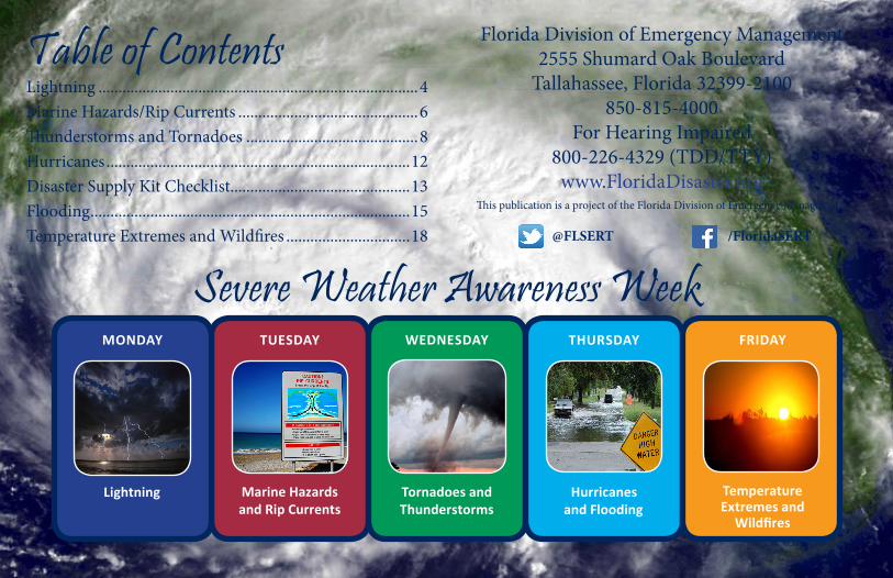
Table of Contents
Severe Weather Awareness Week
Lightning ................................................................................4 Marine Hazards/Rip Currents .............................................6 Thunderstorms and Tornadoes ...........................................8 Hurricanes ............................................................................12 Disaster Supply Kit Checklist .............................................13 Flooding ................................................................................15 Temperature Extremes and Wildfires ...............................18
TUESDAY
Marine Hazards and Rip Currents
WEDNESDAY
Tornadoes and Thunderstorms
THURSDAY
Hurricanes and Flooding
FRIDAY
Temperature Extremes and Wildfires
MONDAY
Lightning
@FLSERT /FloridaSERT

2
Message from Florida Governor Rick ScottIn Florida, we are on a mission to make our state the world’s top destination for families to get a great job and live their dreams. We are fortunate to have beautiful weather year-round, and every day, more people move to the Sunshine State to enjoy our great climate and ample business opportunities. In fact, Florida has one of the highest population growth rates and is the third largest state in the nation.
While living in Florida offers many unique benefits and advantages, it is important to remember the severe weather hazards and the potential threats our state sometimes faces. Every Floridian should be aware of potential hazards and prepared to act in case of an emergency. I encourage every family and business to have predefined emergency plans and always keep an emergency supply kit ready and stocked.
Making sure your family and business is prepared well in advance of any potentially severe weather is key in ensuring the safety of our communities, homes and loved ones.
This Severe Weather Awareness Guide contains valuable information on how you and your family can remain safe in an emergency. Join us in our commitment to keeping Floridians safe by taking the steps right now to ensure you and your loved ones are prepared for any challenges that may arise. Resilience and preparedness start at home.
Follow Governor Scott at @FLGovScott

3
Message from the Florida Division of Emergency Management Director Wesley MaulThe 2017 Atlantic Hurricane Season was a very active and extremely destructive season, with 17 total named storms, becoming the 5th-most active recorded season. Hurricanes Harvey, Irma and Maria, along with the many other named storms, posed significant challenges. Floridians met these challenges head-on, with determination and positivity.
After many relatively calm years, last season’s events serve as reminder of how disasters can occur at any time and without warning. It is important to be aware of all the different hazards you might be exposed to and to take all necessary steps to be prepared at all times. Be familiar with evacuation zones and routes. Make sure disaster supply kits are always ready and properly stocked. Have a plan for receiving important alerts in case of an emergency.
I encourage Floridians to use this guide, along with the many other available resources, to familiarize themselves with some of Florida’s weather hazards and to educate themselves on the proper steps to preparedness, such as creating appropriate emergency plans and building disaster supply kits.
Together, we can build stronger, more resilient communities and reduce the impact of severe weather events. Visit FloridaDisaster.org for more information and FloridaDisaster.org/AlertFL to sign up to receive alerts straight to your phone.
Follow Florida SERT @FLSERT
4
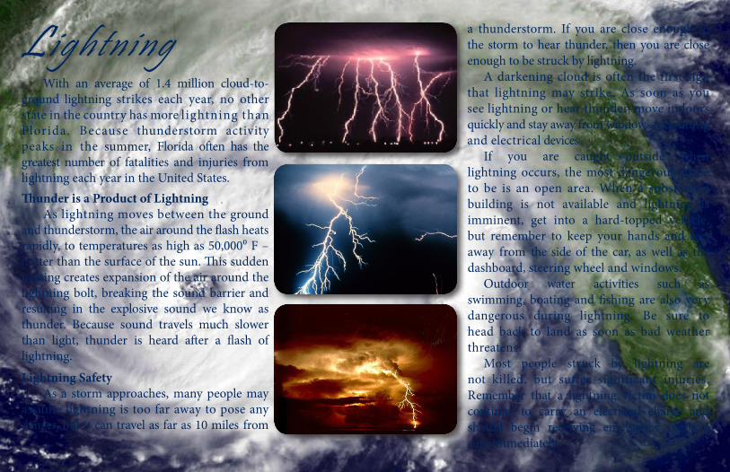
With an average of 1.4 million cloud-to-ground lightning strikes each year, no other state in the country has more lightning than Florida. Because thunderstorm activity peaks in the summer, Florida often has the greatest number of fatalities and injuries from lightning each year in the United States. Thunder is a Product of Lightning As lightning moves between the ground and thunderstorm, the air around the flash heats rapidly, to temperatures as high as 50,000⁰ F – hotter than the surface of the sun. This sudden heating creates expansion of the air around the lightning bolt, breaking the sound barrier and resulting in the explosive sound we know as thunder. Because sound travels much slower than light, thunder is heard after a flash of lightning.
Lightning Safety As a storm approaches, many people may assume lightning is too far away to pose any danger, but it can travel as far as 10 miles from
a thunderstorm. If you are close enough to the storm to hear thunder, then you are close enough to be struck by lightning. A darkening cloud is often the first sign that lightning may strike. As soon as you see lightning or hear thunder, move indoors quickly and stay away from windows, plumbing and electrical devices. If you are caught outside when lightning occurs, the most dangerous place to be is an open area. When a substantial building is not available and lightning is imminent, get into a hard-topped vehicle, but remember to keep your hands and feet away from the side of the car, as well as the dashboard, steering wheel and windows. Outdoor water activities such as swimming, boating and fishing are also very dangerous during lightning. Be sure to head back to land as soon as bad weather threatens. Most people struck by lightning are not killed, but suffer significant injuries. Remember that a lightning victim does not continue to carry an electrical charge and should begin receiving emergency medical care immediately.
Lightning

5
Negative to positive!Lightning happens when the negative charges, which are called electrons – in the bottom of the cloud or in this experiment your finger – are attracted to the positive charges, which are called protons, in the ground or in this experiment the aluminum pie pan. The resulting spark is like a mini lightning bolt.
When thunder roars, first go indoors!Then use the 30-30 Rule to determine the threat of lightning in your area before going out again.
30 Seconds – Count the seconds between seeing lightning and hearing thunder. If the time is less than 30 seconds, lightning is still a potential threat. Seek shelter immediately.
30 Minutes – After hearing the last thunder, wait 30 minutes before leaving shelter. Many lightning deaths occur after the storm passes. Stay in a safe area until you are sure the threat has passed.
Make Lightningaluminum pie pan small piece of wool fabric
styrofoam plate pencil with a new eraser thumbtack
Materials You Will Need
Process
Why Does This Happen?
• Push the thumbtack through the center of the aluminum pie pan from the bottom
• Push the eraser end of the pencil into the thumbtack.
• Put the styrofoam plate upside-down on a table. Quickly, rub the underneath of the plate with the wool for a couple of minutes.
• Pick up the aluminum pie pan using the pencil as a handle and place it on top of the upside down styrofoam plate that you were just rubbing with the wool.
• Touch the aluminum pie pan with your finger. You should feel a shock. If you don’t feel anything, try rubbing the styrofoam plate again.
• Once you feel the shock, try turning the lights out before you touch the pan again. You should see a spark. You made lightning!
The 30-30 Rule

6
Marine Hazards/Rip Currents Florida’s weather and water can change rapidly, posing a threat to boater and swimmer safety. The day’s weather can quickly bring hazards such as severe thunderstorms, strong winds, rough seas, lightning, waterspouts or rip currents. Strong wind gusts can produce locally rough seas as high as 12 feet in a matter of moments. These conditions can possibly overturn small boats and torrential rains can reduce visibility to near zero. At the beach, rough waves can knock an unsuspecting swimmer down and make them susceptible to rip currents. If you hear thunder, you could potentially be struck by lightning. Boaters should return to port anytime thunder is heard. If you are unable to reach safe shelter on a boat, go below deck or get as low as possible. Stay away from masts or metal objects. Those at the beach should seek shelter in a hard-topped vehicle. A waterspout is a tornado over water that can easily overturn boats and create locally hazardous seas. Waterspouts can form during severe thunderstorms that occur over water, but they also can form during fair and relatively calm weather. These “fair weather waterspouts” may not be as strong, but can still easily damage or destroy a small boat. If caught near a waterspout, move at a 90 degree angle from its apparent movement, then seek safe harbor. A safe and enjoyable Florida boating experience is up to
you. Always plan ahead and remember these safe boating and beach practices:• Check forecasts well ahead of time.• Be sure everyone aboard is wearing a life jacket.• If caught in a thunderstorm, go below deck if possible, and stay
away from masts or ungrounded metal objects.• Have a VHF marine band radio on board.• Know the limitations of your boat. If small craft advisories or
gale warnings are issued, you should postpone travel.
Rip CurrentsA rip current is like a shallow river or channel of water flowing away from shore. Rip currents can last from a few minutes to a few hours, and can extend as far as 100 yards offshore Weather or ocean conditions can cause rip currents to be more frequent or stronger in intensity. Tropical storms and hurricanes can easily create rip currents in Florida, even if they are several hundred miles away. Rip currents typically form along the beach at breaks in the offshore underwater sandbar, and structures such as piers and jetties can often result in permanent rip currents alongside these structures.
Rip currents are dangerous. Rip currents pull unprepared swimmers away from shore into deeper water. If caught in a rip current swim sideways, parallel to the beach until you are out of the rip current. Then swim to shore at an angle, away from the current.

7
At speeds of up to five miles per hour, the force of a rip current is too strong for anyone to swim against, and attempts to swim directly back to shore, especially for a panicked and tired swimmer, can be fatal.
Know Before You Go Before leaving home, be sure to check the expected beach and water conditions. Visit www.ripcurrents.noaa.gov/forecasts.shtml for your area’s rip current outlook. The National Weather Service also issues Coastal Waters Forecasts, which include a five-day forecast of wind direction, wind speed, wave height and precipitation. When at the beach, look for the nearest lifeguards and check with them about existing water conditions. Obey all instructions or orders from lifeguards or beach patrol. If you’re going to a beach with no lifeguard on duty, look for warning flags or signs and know what the colors mean. Remember, swimming in the surf is not the same as swimming in a pool or lake. If winds are strong or the surf is rough, avoid going into the water above your knees and swim with a buddy.
Follow these safety tips to ensure a safe and enjoyable beach trip:
• If you find yourself caught in a rip current, doing two simple things will increase your chances of survival – don’t panic and don’t fight the current! Just remembering the simple phrase “Don’t fight...Swim left or right” could save your life.
• If possible, swim at beaches with lifeguards or beach patrol.
• If caught in a rip current, stay calm, yell for help, and swim sideways, parallel to the beach until you are out of the rip current. Then swim to shore at an angle, away from the current and
towards shore.
• If you are unable to swim out of the rip current, float or calmly tread water. When out of the current, swim towards shore.
• Don’t get caught in a rip current trying to save someone else. Throw the person a flotation device, yell instructions on how to escape and get help from beach patrol.
DID YOU KNOW?Rip currents claim more lives in Florida than hurricanes, floods, tornadoes and lightning combined.
Sometimes, you can look for signs of rip currents in the water:
l A narrow channel where there is a noticeable difference in water color (appears brown from sand)
l A line of foam or seaweed moving in the opposite direction of the incoming waves
l A visible area of choppy or churning water
l A break in the wave pattern

8
Thunderstorms and Tornadoes
Sometimes, strong thunderstorm wind gusts, often called downbursts, can produce as much damage as a tornado. Downbursts can snap trees, blow down signs and cause roof damage.
Waterspouts A waterspout is a tornado over water. Florida waterspouts come in all shapes, sizes, and intensities. Waterspouts can form year round in Florida, during the peak summer months, as well as more intense waterspouts during the winter or spring months and within hurricane or tropical storm rain bands. Waterspouts are quite common over the waters along the Florida Keys, the lagoons and rivers along the Florida Treasure Coast, and Tampa Bay. Waterspout winds can reach and exceed 40-90 mph, which is strong enough to swamp or capsize a small watercraft. All waterspouts pose a threat to boater safety, and should be avoided.
Thunderstorms are a frequent part of life in Florida. Thunderstorms occur in all seasons of the year, but they are more numerous during the summer. Florida has the greatest number of thunderstorms in the United States, occurring 75 to 105 days each year. Florida experiences more thunderstorms than others states because: (1) Florida is located close to large bodies of water that provide moisture; (2) Florida receives plenty of sunlight, which warms the air near the ground; and, (3) Sea breeze boundaries can move onshore and provide a source of lift for the thunderstorms. Thunderstorms can produce dangerous hazards such as lightning, tornadoes, hail, strong winds and heavy rain that can lead to flooding. A thunderstorm is considered “severe” when it produces winds in excess of 58 mph, hail that is one inch across or larger (the size of a U.S. quarter), or if it produces a tornado. Tornadoes develop within very strong thunderstorms when rising air currents in a storm begin to rotate. If the rotation is strong enough and can last for a long enough period of time, a funnel cloud can drop from the clouds and touch ground. Some thunderstorms may produce several tornadoes. Tornadoes also can occur near the edge of tropical cyclones, in squalls called rain bands. These tornadoes often occur more than 100 miles from the center of the tropical cyclone. Tornadoes usually last only a few minutes, but often cause severe damage. The damage area of a tornado is usually narrow, but in its direct path winds can be as strong as 200 mph.

9
However, an actual tornado is typically too small for the Doppler radar to detect. Therefore, meteorologists depend on volunteer storm spotters who report funnel clouds, tornadoes and other severe weather to the National Weather Service. The National Weather Service will issue a Tornado Warning when a tornado has been either seen by a weather spotter or when Doppler radar indicates strong rotation inside a thunderstorm.
Thunderstorm and Tornado Safety Actions If a Severe Thunderstorm Warning or Tornado Warning is issued for your area, seek shelter immediately! Find shelter in a small, interior room on the lowest floor of your home and stay away from windows, doors and electrical equipment. Avoid rooms that are near tall structures like trees and power lines. Leave mobile homes and find a stronger building or house. In the classroom, seek shelter in a hallway or closet, or get underneath a desk or table and cover your head with your arms. If
caught outdoors or on the road try to get as low as possible, such as in a creek bed or ditch, and cover your head.
Florida Tornadoes Most Florida tornadoes occur in the afternoon and early evening hours during the summer months of June, July and August. These tornadoes tend to be weaker in strength but can still produce damage. Stronger and more devastating tornadoes can occur in Florida mainly in the late winter and spring when strong cold fronts move through the state and provide the necessary conditions for tornadoes to form. Tornadoes have occurred in every month in Florida, even on Christmas Day. Tornadoes can also strike at any time of day. Most of Florida’s tornado-related deaths occur during overnight hours. Since 1950, only three states – Texas, Kansas and Oklahoma – have reported more tornadoes than Florida. Florida also ranks fourth in damage caused by tornadoes. National Weather Service (NWS) meteorologists use Doppler radar to track thunderstorm development, severity, and movement. “Severe Thunderstorm Warnings” are issued when a thunderstorm in the area is capable of causing damage and is a threat to life and property. Doppler radar also identifies the rotation inside a thunderstorm, which could be the beginning of a tornado.

10
Myth: Overpasses offer suitable shelter if you are caught outside in a tornado.Fact: Seeking shelter in an overpass is more dangerous compared to standing in an open field during an approaching tornado. Winds will be funneled under the bridge which will increase the speed. Additionally, debris also tends to collect in overpasses from a passing tornado which could cause significant harm to those seeking shelter there. It is best to seek shelter in an interior room on the lowest floor of a sturdy building. If no building is available, lie flat on the ground and cover your head.
Myth: If a tornado is not coming directly at you, you are safe.Fact: Tornadoes have been known to act erratically, often changing directions quickly. Do not put yourself in harm’s way, sturdy shelter is the only safe place to be during a tornado.
Tornadoes Myth vs. Fact
Myth: Tornadoes have picked up people and items up, carried them some distance and then set them down without injury or damage.Fact: People and animals have been transported up to a quarter mile or more without serious injury. Fragile items, such as sets of fine china, or glass-ware have been blown from houses and recovered, miles away, without any damage. However, given the quantity of airborne debris, these occurrences are the exception, rather than the norm. Myth: You can outrun a tornado, especially in a vehicle. Fact: Tornadoes can move at up to 70 mph or more and shift directions erratically and without warning. Do not try to outrun a tornado.
Myth: Open the windows of a home to help equalize the pressure and minimize the damage to the home in the event of an oncoming tornado.Fact: Although there are pressure changes within tornadoes, most of the damage to structures will be caused by the winds and the debris carried by the winds. All homes will equalize its pressure inside since no house is 100% sealed.

11
Make A Tornado in a TubeTwo empty 2-liter soda bottles, clear
food coloring water Tornado Tube Connector**If you cannot find a Connector, use duct or electrical tape instead
Gravity and motion mix up a storm!Gravity is causing the water in the top bottle to flow into the empty bottom bottle. When the water is swirling, it creates a vortex which allows the liquid to travel in a circle around the center inside the bottle. This allows the displaced air to flow up from the center of the vortex as the water swirls around the sides and f lows into the bottom bottle. Can you get the tornado in the bottle to spin both clockwise and counter-clockwise?
Hurricanes, winter storm and other low pressure systems in the northern hemisphere all have a similar counter-clockwise spin due to the Coriolis Force. This is because these hurricanes and winter storms are very large – some spanning several states. Tornadoes are also considered low pressure systems, but even the largest tornadoes are small when compared to a hurricane. The fact that tornadoes are small means that the Coriolis Force does not affect the rotation of a tornado. As a result, just like in the tornado tube, tornadoes can spin in both clockwise and counter-clockwise directions.
Why Does This Happen?
Materials You Will Need
Process1. Remove labels, caps and plastic ring seals from the soda
bottles.2. Fill one of the bottles 3/4 full with water and add food
coloring3. Connect the bottles by screwing the connector onto
the bottle filled with water. Now, screw the empty bottle into the other side of the connector; make sure both bottles are screwed in tightly so the water does not leak. If you do not have a connector, secure the openings together with duct tape or electrical tape. (Once connected, the bottles should make an hourglass shape)
4. Flip the tubing upside down so the filled bottle is now on top.
5. Holding the top bottle, swirl the water for a few seconds.6. The water should now swirl into a tornado!
12
Freshwater flooding from torrential rains can produce a lot of damage, regardless of its intensity. Also, freshwater flooding may occur hundreds of miles away from the cyclone center, meaning that storms which do not make landfall in the state may still bring significant rainfall. All Florida residents and seasonal visitors should determine if they live within a low-lying area at risk to flooding, regardless of their location in the state. Storm surge is the term used to describe the wall of water that is pushed toward the coast as a hurricane moves onshore. A major hurricane can produce a surge
of 10 feet or more above the normal levels. This amount of water easily can flood coastal communities. Worldwide, approximately 90 percent of all deaths in hurricanes are drownings in either storm surge or rainfall flooding. Tornadoes associated with tropical systems can develop suddenly and strike a community even though the center of the hurricane may be more than 100 miles away.
Preparing for a hurricane All Florida residents and visitors should prepare each year for the possibility of tropical storm or hurricane impacts, understand the potential hazards posed by them, and have a plan. First, determine whether you live in an evacuation zone. This information can be obtained from your local emergency management office.
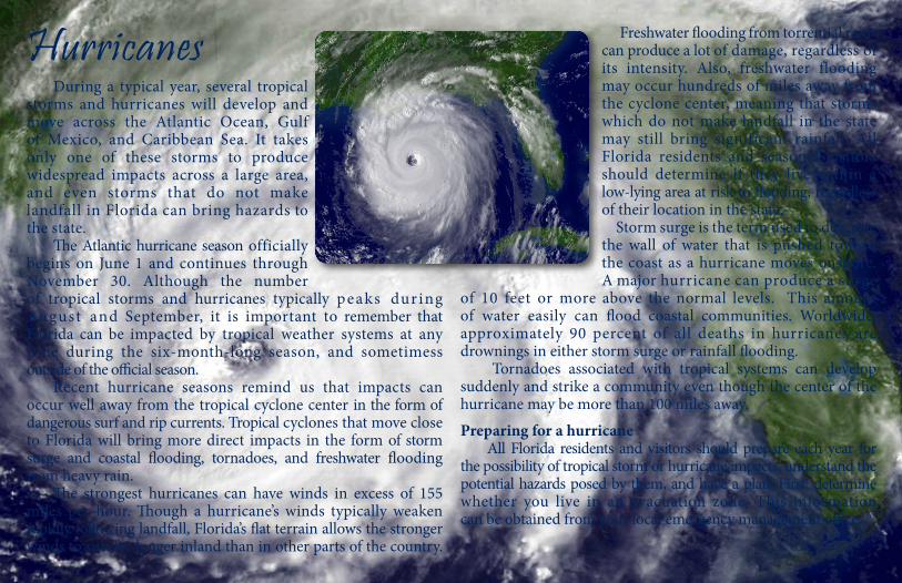
Hurricanes During a typical year, several tropical storms and hurricanes will develop and move across the Atlantic Ocean, Gulf of Mexico, and Caribbean Sea. It takes only one of these storms to produce widespread impacts across a large area, and even storms that do not make landfall in Florida can bring hazards to the state. The Atlantic hurricane season officially begins on June 1 and continues through November 30. Although the number of tropical storms and hurricanes typically peaks dur ing August and September, it is important to remember that Florida can be impacted by tropical weather systems at any time during the six-month-long season, and sometimess outside of the official season. Recent hurricane seasons remind us that impacts can occur well away from the tropical cyclone center in the form of dangerous surf and rip currents. Tropical cyclones that move close to Florida will bring more direct impacts in the form of storm surge and coastal flooding, tornadoes, and freshwater flooding from heavy rain. The strongest hurricanes can have winds in excess of 155 miles per hour. Though a hurricane’s winds typically weaken rapidly following landfall, Florida’s flat terrain allows the stronger winds to survive longer inland than in other parts of the country.
13
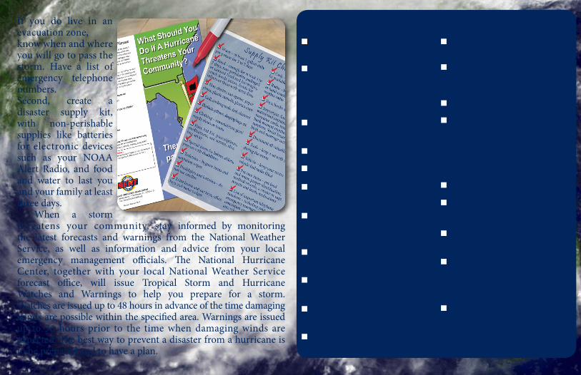
If you do live in an evacuation zone, know when and where you will go to pass the storm. Have a list of emergency telephone numbers. Second, create a disaster supply kit, with non-perishable supplies like batteries for electronic devices such as your NOAA Alert Radio, and food and water to last you and your family at least three days. When a storm threatens your community, stay informed by monitoring the latest forecasts and warnings from the National Weather Service, as well as information and advice from your local emergency management officials. The National Hurricane Center, together with your local National Weather Service forecast office, will issue Tropical Storm and Hurricane Watches and Warnings to help you prepare for a storm. Watches are issued up to 48 hours in advance of the time damaging winds are possible within the specified area. Warnings are issued up to 36 hours prior to the time when damaging winds are expected. The best way to prevent a disaster from a hurricane is to be prepared and to have a plan.
q Water – at least 1 gallon daily per person for 3 to 7 days
q Food – enough for at least 3 to 7 days; non-perishable packaged or canned food and beverages, snack foods, juices, foods for infants or those with strict diets
q Non-electric can opener, paper plates, plastic utensils, plastics cups
q Grill, cooking tools, fuel, charcoal
q Blankets, pillows, sleeping bags, etc.
q Clothing – seasonal/rain gear/sturdy shoes or boots
q First Aid Kit, prescriptions, medications, sun screen, aloe and bug spray
q Special items for babies, elders, persons with disabilities
q Toiletries – hygiene items and sanitation wipes
q Flashlights and batteries – do not use candles
q Extra house and car keys, office keys and name badges
q Cash – banks/ATMs may not be available after a storm
q Radio – battery operated or hand cranked radio, NOAA weather radio
q Toys, books and games
q Important documents in a waterproof container – include insurance cards, medical records, bank account numbers, credit card numbers, Social Security cards, birth and marriage certificates, etc.
q Document all valuables
q Tools – keep a set with you during the storm
q Vehicle – keep your motor vehicle fuel tanks filled
q Pet care items – pet food and water, proper identification, medical records, a carrier or cage, muzzle and leash, medications
q List of important telephone numbers – including your county emergency management office, evacuation sites, doctors, bank, area schools, veterinarian, etc.
D i s a s t e r S u p p l y K i t C h e c k l i s t

14
Severe Weather Crossword
Across:5. This type of flood can occur within minutes of heavy rainfall.7. This can develop within a very strong thunderstorm, when rising air currents in a storm begin to rotate.8. Sunstroke, heat cramps, heat exhaustion and heat stroke are all associated with a high this.9. These warnings are issued by the National Weather Service to alert people to conditions that may add to wildfire danger.10. The term for the “wall of water” pushed on shore during a hurricane.
Down:1. Measurement of water you need per person per day to prepare for a disaster.2. When caught in this - don’t fight, swim left or right! 3. When this roars, go indoors!4. If you hear thunder, you are close enough to the storm to get struck by this.6. Hurricane Season begins June 1st, and ends on the 30th of this month.
Answers are found throughout the Severe Weather Awareness Guide.

15
off the road; and it may only take 12 to 16 inches of water to cause a car to float. Driving on flooded roads is also dangerous because the road may be washed out, or there are unseen dangers in the water that could cause damage to your vehicle and threaten your life. When you encounter a flooded roadway, it is important to remember, “Turn around. Don’t drown!” Florida has more than 2,200 miles of tidal shoreline. Because of this, many areas of Florida are also prone to coastal
flooding. This may come from storm surge associated with tropical cyclones or from other causes such as strong onshore winds or higher than normal tides due to lunar effects. Meteorologists at the National Hurricane Center, the Southeast River Forecast Center, and local Florida National Weather Service offices all watch thunderstorms and tropical systems very closely to forecast how much rainfall it may produce and how much flooding may occur. The National Weather Service will issue coastal flood advisories, watches and warnings similar to inland flood statements.
Flooding Safety Actions• Never play in flooded areas where hidden sharp objects,
electrocution and pollution are serious hazards.• In highly flood-prone areas, keep materials such as sandbags,
plywood, plastic sheeting, plastic garbage bags, lumber and shovels on hand.
Flooding Florida is vulnerable to flooding at any time of the year. Mostly surrounded by water, the abundant supply of moisture feeds the development of thunderstorms, which may produce heavy rains over a short period of time. When those heavy rains occur, the ground may not be able to absorb all of the rainwater and flooding may result. Due to the flat ground in portions of the state, floodwaters may sometimes remain in an area for days, weeks or even months. Not all floods are alike. Some floods develop slowly, taking anywhere from a few hours to a few days to have an impact. On the other hand, flash floods happen quickly, sometimes in a matter of minutes.
Urban Flooding As Florida’s population increases, buildings and pavement replace the natural land. This creates more water runoff and can increase flood problems in urban areas, which can be especially dangerous and costly in these developed areas where we live and drive. Flooding can cause harm to animals and damage to any type of structure, including homes, bridges, buildings, roads, power and sewer systems. Most flooding related deaths in the United States are due to people driving their cars into flooded areas. Moving water only as deep as a car’s hubcaps can be enough to move the car

16
• Be aware of streams, canals and areas that are known to flood so you or your evacuation routes are not cut off.
• Never drive into moving water. If you cannot see the roadway beneath the water, do not drive through it! The water may be deeper than it appears and the road may already be washed away.
• Do not use food that has come in contact with floodwaters.
• Consider purchasing a federal flood insurance policy. You can learn more about strengthening your home at flash.org and about federal flood insurance at floodsmart.gov/floodsmart
Flooding Facts• Six inches of water will reach the bottom of most passenger
cars, causing loss of control and possible stalling.• Two feet of rushing water can carry away most vehicles,
including sport utility vehicles (SUVs) and pick-ups.• Urban and small-stream flash floods can occur under one hour.• Flood damages are not covered under homeowners’ insurance
policies. All homeowners should consider purchasing federal flood insurance.
Urban Flood
River Flood
Area Flood
Flash floods can occur within a few minutes or hours of heavy rainfall or from a dam or levee failure. These floods can destroy structures, down trees, roll boulders, and create new waterways. Rapidly rising water can reach heights of 30 feet or more! Furthermore, flash flood producing rains can also trigger catastrophic mudslides. You may not always have a warning of these sudden and potentially deadly floods.
Floods can be magnified in urban areas. As land is converted from fields and woodlands to roads and parking lots, it loses it ability to absorb rainfall. Urbanization increases runoff two to six times over what would occur on natural terrain. During periods of urban flooding, streets can become swift moving rivers, while basements can become death traps as they fill with water.
Low lying areas near rivers, streams, lakes and reservoirs are susceptible to river floods. Some river floods occur seasonally when winter or spring rains fill river basins with too much water too quickly. Other floods can occur from slow-moving low pressure systems. Torrential rains from decaying hurricanes or tropical systems can also produce river floods.
Area floods are long-lived, though not usually life-threatening. Standing water in low-lying areas, such as an open field, is an example of an area flood. Significant agricultural losses and displaced livestock can occur with theses floods. In addition, stagnant water from this type of flooding can serve as a breeding ground for insects and diseases.
Flash Flood

17
Make a list of other important supplies you would include in your disaster supply kit.
q Gamesq Radioq Flashlightq Waterq Can Opener
q Batteriesq First Aid Kitq Important Papersq Canned Goods
Start Here! I’m Prepared!
1. _______________________2. _______________________3. _______________________4. _______________________5. _______________________
Enter the maze and collect the supplies you should include in your disaster supply kit.
Enter the maze at Start Here! to collect your disaster supplies. When your disaster supply kit is full, you will be Prepared!Disaster Supplies

18
Temperature Extremes and Wildf ire s Florida can experience a wide range of temperatures, from dangerously hot to dangerously cold, and it is important for everyone to stay safe during periods of temperature extremes. When Florida’s high humidity combines with warm temperatures, it may feel hotter outside than it really is. This is called the heat index. High heat index values limit the body’s ability to cool through sweating. When the heat index exceeds 105° F, conditions can become dangerous for people and animals. Sunstroke, heat cramps, heat exhaustion and heat stroke are all risks associated with high heat indices. The National Weather Service will issue heat advisories and warnings when the heat index is forecast to reach dangerous levels.
Hot Weather Safety• Wear lightweight, light-colored
clothing to help reflect heat and sunlight, and help your body maintain its normal temperature.
• Drink plenty of water, even if you don’t feel thirsty. People can become dehydrated without realizing it. Stay away from highly sugared or carbonated drinks.
• Protect your skin with sunscreen; also wear sunglasses and a hat, or carry an umbrella to provide shade.
• Slow down and limit outdoor activities. Avoid outdoor events during the hottest part of the day (11 am–5 pm). Remain in air-conditioned places to reduce your exposure to the heat.
• Check on elders, persons with disabilities, children and animals during periods of prolonged heat.
Cold weather outbreaks occur in Florida at least once a year, caused by strong cold fronts that move through the state and producing below freezing temperatures and strong winds. When strong winds combine with cold temperatures, heat loss from
a person’s skin can be accelerated. Wind Chill can make the outside temperature feel much colder than it really is. In addition, freezing temperatures can kill crops, plants and even fish. The National Weather Service will issue wind chill advisories/warnings, along with freeze advisories/warnings, when cold weather threatens an area.
Cold Weather Safety When cold weather is in the forecast, it is important to remember the “5 P’s of Cold Weather Safety.”

19
• Protect People: dress in layers and wear a hat and gloves. Stay out of the wind and to stay dry. Remember to check on young children and elders who are the most sensitive to cold weather.
• Protect Pets: Be sure to bring outdoor pets inside or give them a warm shelter.
• Protect Plants: Cover cold-sensitive plants to protect them from the dangerous temperatures.
• Protect Pipes: Cover pipes and allow outdoor faucets to slowly drip to prevent them from freezing and breaking.
• Practice Fire Safety: Use safe-heating sources indoors. Do not use fuel-burning devices such as grills; they release carbon monoxide, which is a deadly gas. Also, make sure to use space heaters according to their instructions and be attentive to open flames.
Wildfire Safety While wildfires can start at any time of the year, the state sees a peak of activity during the early, colder part of the year – beginning in January and continuing until early to mid-June. A typical year in Florida will see over 4,600 fires burn nearly 110,000 acres of land. Since 2002, more than two million acres of forest land have been burned by wildfires. While there are natural ways a wildfire can be ignited, most wildfires are started by humans. The most common causes of
human-started fires are arson and yard waste burns that get out of control. Fires can also be caused by discarding a cigarette that has not been fully extinguished. Other causes of wildfires include campfires and bonfires not properly extinguished or windy conditions that may take hot embers from the fire to another location. The stronger the wind and the drier the ground, the faster fires will spread. Fire Weather Watches and Red Flag Warnings are issued by the National Weather Service to alert people to hazardous weather conditions that may add to the wildfire danger.
Wildfires can cause major environmental, social and economic damages. Prescribed fires are good fires that reduce the hazardous accumulations of brush to lower the risk of loss to homes, businesses, recreation areas and forests when wildfires occur. Prescribed fire also controls forest tree diseases and recycles nutrients in the soil. Wildfires often begin unnoticed. They spread quickly, igniting grasses, trees and homes. Reduce your risk by preparing now - before wildfire strikes. Meet with your family to decide what to do and where to go if wildfires threaten your area. Find out how you can promote and practice wildfire safety by going to www.Firewise.com and www.floridaforestservice.com/wildfire/information.html.

20
T E S Y Y D W K L T X L W F J
A H I U O N O S U I T I L L Y
B L U O P D X O O S T L L C Z
P A L N A P P M R N I H D R D
H F L N D S L U S H G T F I O
K A R W R E B Y C Z Q M I P N
E O Z E I N R D K T S D R C L
T J T A W N N S L I M N E U I
K A Y O R I D X T R T Q B R G
W I D T W D H C H O I E N R H
H U R R I C A N E R R M E E T
H E A T I N D E X A Q M X N N
W A R N I N G P K D L B O T I
W A T C H D H W X I V L L A N
M I E H D M F T J O I O F O G
Hidden below are some basic terms used throughout the Severe Weather Awareness Guide. Try to find them all!
DOWNBURSTFLOODHAZARDHEAT INDEX HURRICANELIGHTNINGRADIORIP CURRENTSUPPLY KITTHUNDERSTORMTORNADOWARNINGWATCHWATERSPOUTWIND CHILL
qqqqqqqqqq
Word SearchCheck off the words as
you find them!
qqq
q

21

22
Special Thanks to our Partners!