Embed Size (px)
Citation preview
© Biosis September 2012 – Leading ecology and heritage consultants 1
Flora, Fauna and Habitat Hectare Assessment of Ajax Road, Altona Prepared for Axxcel Management Services
23 November 2012

© Biosis 2012 – Leaders in Ecology and Heritage Consulting 2
Biosis Pty Ltd
This document is and shall remain the property of Biosis Pty Ltd. The document may only be used for the
purposes for which it was commissioned and in accordance with the Terms of the Engagement for the
commission. Unauthorised use of this document in any form whatsoever is prohibited.
Disclaimer:
Biosis Pty Ltd has completed this assessment in accordance with the relevant federal, state and local
legislation and current industry best practice. The company accepts no liability for any damages or loss
incurred as a result of reliance placed upon the report content or for any purpose other than that for which it
was intended.
Biosis offices
AUSTRALIAN CAPITAL TERRITORY
Canberra
Unit 16 / 2 Yallourn Street
Fyshwick ACT 2609
Phone: (02) 6228 1599
Fax: (02) 6280 8752
Email: [email protected]
NEW SOUTH WALES
Sydney
18–20 Mandible Street
Alexandria NSW 2015
Phone: (02) 9690 2777
Fax: (02) 9690 2577
Email: [email protected]
Wollongong
8 Tate Street
Wollongong NSW 2500
Phone: (02) 4229 5222
Fax: (02) 4229 5500
Email: [email protected]
QUEENSLAND
Brisbane
Suite 4 First Floor, 72 Wickham Street
Fortitude Valley QLD 4006
Phone: (07) 3831 7400
Fax: (07) 3831 7411
Email: [email protected]
VICTORIA
Ballarat
506 Macarthur Street
Ballarat VIC 3350
Phone: (03) 5331 7000
Fax: (03) 5331 7033
Email: [email protected]
Melbourne (Head Office)
38 Bertie Street
Port Melbourne VIC 3207
Phone: (03) 9646 9499
Fax: (03) 9646 9242
Email: [email protected]
Wangaratta
26a Reid Street (PO Box 943)
Wangaratta VIC 3677
Phone: (03) 5721 9453
Fax: (03) 5721 9454
Email: [email protected]
Report to: Axxcel Management Services
Prepared by: Steve Mueck
Clare McCutcheon
Sally Koehler
Biosis matter no.: 15746, 12374 & 12238
Version/date Internal review by Date sent to client
Draft version 01 MDD 08/03/11
Final version 01
Final version 02
SGM
SGM
18/04/11
29/11/12
File name: 15746.AjaxRoad.FFHHa.DFT.23112012.docx
Citation: Biosis (2012). Ajax Road, Altona: Flora, fauna and habitat hectare
assessment. Report for Axxcel Management Services. Authors: S Mueck, C
McCutcheon & S Koehler, Biosis Pty Ltd, Melbourne. Project No. 15746.
Acknowledgements
Biosis Research acknowledges the contribution of the following people
and organisations in undertaking this study:
• Axxcel Management Services: Nigel Sharp
• Department of Sustainability & Environment for access to the
Victorian Biodiversity Atlas
The following Biosis Research staff were involved in this project:
• Stephen Page & Paul Young for mapping
• Matt Dell for report review
© Biosis 2012 – Leaders in Ecology and Heritage Consulting III
Contents
1. Introduction .................................................................................................................................................... 1
1.1 Project background .................................................................................................................................................................. 1
1.2 Scope of assessment ............................................................................................................................................................... 1
1.3 Location of the study area ...................................................................................................................................................... 1
2. Methods ........................................................................................................................................................... 2
2.1 Literature and database review............................................................................................................................................. 2
2.1.1 Definitions of significance ....................................................................................................................................... 2
2.1.2 Likelihood of occurrence ......................................................................................................................................... 2
2.2 Site investigation ....................................................................................................................................................................... 3
2.2.1 Flora assessment ....................................................................................................................................................... 3
2.2.2 Fauna assessment .................................................................................................................................................... 4
2.3 Legislation and policy ............................................................................................................................................................... 5
2.4 Victoria's Native Vegetation Management Framework .................................................................................................... 6
2.5 Mapping ...................................................................................................................................................................................... 6
3. Results .............................................................................................................................................................. 7
3.1 Site Context ................................................................................................................................................................................ 7
3.2 Limitations .................................................................................................................................................................................. 7
3.3 Flora ............................................................................................................................................................................................. 7
3.3.1 Ecological Vegetation Classes ................................................................................................................................. 8
3.3.2 Species ......................................................................................................................................................................... 9
3.4 Fauna ........................................................................................................................................................................................... 9
3.4.1 Habitats ....................................................................................................................................................................... 9
3.4.2 Species ....................................................................................................................................................................... 13
3.5 Further survey recommendations ...................................................................................................................................... 15
3.6 Summary of biodiversity values of the site ....................................................................................................................... 15
4. Biodiversity Legislation and Government Policy ................................................................................... 16
4.1 Commonwealth ...................................................................................................................................................................... 16
4.1.1 Environment Protection and Biodiversity Conservation Act 1999 ............................................................... 16
4.2 State ........................................................................................................................................................................................... 16
4.2.1 Flora and Fauna Guarantee Act 1988 (FFG Act) ................................................................................................ 16
4.2.2 Planning and Environment Act 1987 (incl. Planning Schemes) ..................................................................... 17
4.2.3 Native Vegetation Management Framework .................................................................................................... 18
4.2.4 Wildlife Act 1975 and associated Regulations ................................................................................................... 18
4.2.5 Water Act 1989 ......................................................................................................................................................... 19
4.2.6 Environment Protection Act 1970: State Environmental Protection Policy (Waters of Victoria) 2003 .. 19
4.2.7 Regional Catchment Strategy and River Health Strategy ............................................................................... 19
© Biosis 2012 – Leaders in Ecology and Heritage Consulting IV
5. Victoria’s Native Vegetation Management Framework (Net Gain) ................................................... 20
5.1 Quantifying native vegetation on site ................................................................................................................................ 20
5.1.1 Patches of native vegetation ................................................................................................................................. 20
5.2 Offsets available on site ........................................................................................................................................................ 22
5.2.1 Patches of native vegetation ................................................................................................................................. 22
5.3 Summary of net gain offsets ................................................................................................................................................ 23
6. Recommendations to Minimise Impacts ................................................................................................. 24
Appendices ............................................................................................................................................................ 27
A1.1 Species and Communities .................................................................................................................................................... 28
A1.2 Sites ............................................................................................................................................................................................ 29
Appendix 6: DSE Net Gain Calculator Output ................................................................................................. 61
Glossary and Abbreviations ............................................................................................................................... 67
Figures .................................................................................................................................................................... 71
List of Figures
Figure 1 Location of Lot H, Ajax Road, Altona, Victoria ......................................................................................... 72
Figure 2 Ecological features within Lot H, Ajax Road, Altona................................................................................ 73
Figure 3: Golden Sun Moth targeted survey effort, Ajax Road, Altona.................................................................... 74
List of Tables
Table 1: Likelihood for significant species and examples of criteria ........................................................................ 3
Table 2: Evaluation best/remaining habitat for rare or threatened flora species. ................................................ 11
Table 3: Assessment of the project against the EPBC Act ......................................................................................... 17
Table 4: Quantification and significance of native vegetation patches within the study area. ............................ 21
Table 5: Summary of potential offsets available from south of the Altona railway .............................................. 22
© Biosis 2012 – Leaders in Ecology and Heritage Consulting V
Summary Biosis Research Pty. Ltd. was commissioned by Axxcel Management Services to undertake a flora, fauna and habitat
hectare assessment of land at Lot H, Ajax Road, Altona. The land is proposed for a future development within this
industrial estate.
The site is located approximately 15 km west south west of the Melbourne CBD in Altona, south of the Werribee Rail
line. It covers 73.66 ha and includes most of Lot H (78.05 ha) of the Elfield Industrial Estate. It is currently zoned
Special Use Zone 4 (SUZ4) which is designated for industrial development.
The site supports substantial areas of remnant native vegetation although areas in close proximity to the existing
road network have generally been heavily disturbed and support largely exotic vegetation. The south western
corner of the site is subject to inundation and supports brackish wetlands associated with the estuary of Laverton
Creek.
Flora and Ecological Vegetation Classes
The study area includes a matrix of remnant native vegetation and disturbed industrial land dominated by exotic
species. The areas of native vegetation are classified into three ecological vegetation classes including Plains
Grassland, Plains Grassy Wetland and Brackish Wetland.
A total of 109 indigenous and 80 introduced plant species was recorded from the site. Previous surveys have
recorded an additional 29 native and 22 weed species.
Systematic flora surveys of the study area identified 489 individuals of Spiny Rice-flower. This places this population
within the largest 10% of known populations for this species. These surveys also identified three individuals of
Arching Flax-lily Dianella sp. aff. longifolia (Benambra) and three populations of Pale Spike-sedge Eleocharis pallens.
Two other species of State conservation significance including Creeping Rush Juncus revolutus and Salt Lawrencia
Lawrencia spicata, are recorded by the existing data from the area of Brackish Wetland in the south west of the
study area.
No other significant flora species were detected by the targeted surveys. Other threatened flora may be present
although some, like Small Golden Moths Diuris basaltica, would probably only be detectable in the first spring after a
fire.
Fauna
The site provides potential habitat for a small number of national and state significant fauna species, the most
significant being the EPBC listed Striped Legless Lizard Delma impar and Golden Sun Moth Synemon plana. There is
a record of Golden Sun Moth from within 100 metres of the study area on Ajax Road. Targeted survey between
December 2010 and January 2011 did not detect the species; however, a population may still be present.
Habitat for the state significant Altona Skipper Butterfly was identified within the area of Brackish Wetland in the
south western corner of Lot H. Marginal habitat for the nationally significant Orange-bellied Parrot was also
identified within this area.
Latham’s Snipe (listed as migratory under the EPBC Act) was recorded in the study area. Areas of Plains Grassy
Wetland and Brackish Wetland within the study area provides potential habitat for this species.
Vegetation Condition Assessment (Habitat Hectares)
A total of nine habitat zones were identified. Each habitat zone is assigned an overall habitat score, which is
multiplied by its area to provide the number of habitat hectares present.
© Biosis 2012 – Leaders in Ecology and Heritage Consulting VI
The study area contains a total of 34.9 hectares of native vegetation, which comprises 20.1 habitat hectares (hha).
The habitat score for the habitat zones ranges from 0.39 to 0.72. Habitat Zones 9 and 10 represent the most intact
areas of native vegetation. The vegetation is predominantly of Very High conservation significance (VHCS) but a
small area of High conservation significance (HCS) is also present (HZ 12).
Clearing all of the native vegetation within the study area would result in an offset prescription of over 40 hha, most
of which is of VHCS. Retaining all of the native vegetation south of the Altona Railway Line would result in an offset
prescription of 15.7 hha, most of which is of VHCS.
Government Legislation and Policy
See table at end of summary.
Offset Potential
A total offset of 6.56 hha could be generated through management of vegetation south of the Altona Railway Line
and its protection under a Section 173 agreement (under the Planning and Environment Act 1987 or equivalent). This
increases to an offset potential of 7.79 hha if the land was transferred to a conservation reserve managed by a
government agency.
Based on the like-for-like requirements of the Framework utilising the offsets available from south of the Altona
Railway Line (presuming a transfer to a government authority and management with conservation as one of the
management objectives), this reserve would supply an excess gain of 2.67 hha of VHCS Brackish Wetland and have
a deficit of 0.04 hha of VHCS Plains Grassy Wetland and 10.58 hha of VHCS Plains Grassland.
The proponent is responsible for protection and the first 10 years of management of offset sites. An Offset
Management Plan should be developed for any Net Gain offset sites.
Summary of legislative requirements for development within the study area
Legislation /
Policy
Relevant Ecological Feature on site Permit / Approval
Required
Other Requirements/
Comments
EPBC Act Threatened species (Spiny Rice-flower,
Golden Sun Moth, Latham Snipe)
recorded on site.
Referral
recommended prior to
any development.
Threatened species
surveys completed.
Threatened ecological community
(Natural Temperate Grassland of the
Victorian Volcanic Plain) present.
Referral
recommended prior to
any development.
Threatened
community surveys
completed.
FFG Act Protected Flora Permit
not required
Site is private land.
Planning &
Environment Act
(Hobsons Bay
Council Planning
Scheme)
Native vegetation, including patches of
native vegetation, present.
Planning permit
required, including
permission to lop or
remove native
vegetation.
Comply with 3 step
approach to Net Gain.
May require external
provision of Net Gain
offsets.
Victoria’s Native
Vegetation
Management
Framework
Site supports 34.9 ha of remnant native
vegetation assessable under the
Framework. Much of this vegetation is of
Very High Conservation Significance
DSE would likely be a
referral authority
under any
development proposal
Threatened species
surveys completed.

© Biosis 2012 – Leaders in Ecology and Heritage Consulting 1
1. Introduction
1.1 Project background
Biosis Pty Ltd was commissioned by Axxcel Management Services to undertake a flora, fauna and habitat hectare
assessment of the majority of Lot H, Ajax Road, Altona. The land is proposed for a future development within this
industrial estate.
A due diligence level assessment of the site has previously been conducted for Axxcel Management Services (Biosis
Research 2010).
1.2 Scope of assessment
The objectives of this investigation are to:
• Undertake a field inspection of the flora and fauna values on site;
• Describe the vascular flora (ferns, conifers, flowering plants) and vertebrate fauna (birds, mammals, reptiles
and frogs,) ;
• Map native vegetation and other relevant habitat features;
• Conduct a vegetation quality assessment (habitat hectare assessment);
• Review the implications of relevant biodiversity legislation and policy, including Net Gain policy; and
• Identify the extent of threatened flora populations within the site through systematic survey.
1.3 Location of the study area
The site is located approximately 15 km west south west of the Melbourne CBD in Altona, south of the Werribee Rail
line (Figure 1).
The site covers 73.66 ha and includes about 95% of Lot H (78.05 ha) of the Elfield Industrial Estate. It is currently
zoned Special Use Zone 4 (SUZ4) which is designated for industrial development.
The site is bounded to the north by the Werribee rail line and is traversed by the Altona rail line. The western
boundary of the site abuts Kayes Drain while the eastern boundary includes an unnamed road linking Ajax Road
and Slough Road, the southern boundary of Chester Road, and the western boundary of Galvin Street.
The site supports substantial areas of remnant native vegetation although areas in close proximity to the existing
road network have generally been heavily disturbed and support largely exotic vegetation. The south western
corner of the site is subject to inundation and supports brackish wetlands associated with the estuary of Laverton
Creek.
The study area is within the:
• Victorian Volcanic Plain Bioregion
• Werribee River Basin
• Port Phillip and Westernport CMA
• City of Hobsons Bay

© Biosis 2012 – Leaders in Ecology and Heritage Consulting 2
2. Methods
2.1 Literature and database review
In order to provide a context for the study site, information about the flora of the local area was obtained from
relevant databases. Database searches encompassed an area within 5 kilometres of the study site. Records from
the following databases were collated and reviewed:
• Victorian Biodiversity Atlas ‘VBA_FLORA25, FLORA100 & FLORARestricted’ August 2010 © The State of
Victoria, Department of Sustainability and Environment.
• Victorian Biodiversity Atlas ‘VBA_FAUNA25, FAUNA100 & FAUNARestricted’ August 2010 © The State of
Victoria, Department of Sustainability and Environment.
• EPBC Act DSEWPC database, accessed using the Protected Matters Search Tool (PMST).
Other sources of biodiversity information:
• DSE Biosites Register.
• DSE Biodiversity Interactive Map 2.0 (Modelled 1750 and 2005 EVCs).
• A Census of the Vascular Plants of Victoria (Walsh and Stajsic, 2007).
The site has been subject to ecological assessments in the past including Frood et al. (1997), Biosis Research (2006)
and Biosis Research (2010). Relevant information from these reports was also reviewed and included as
appropriate.
2.1.1 Definitions of significance
Significance of a species or community is determined relative to the scale at which it is considered. The sources
used to categorise significance of species and communities in this report are summarised in Appendix 1.
2.1.2 Likelihood of occurrence
Database searches provide lists of species from the local area that have potential to occur on the site. Where
database records of state and nationally significant species exist from the local area, but these species are not
identified during field survey, it is necessary to consider the likelihood that they occur on the site. The DSEWPC
PMST may nominate EPBC Act-listed species and communities where the site lies within their broad geographic
range.
Likelihood of particular species occurring at a site is determined by assessing factors including the quality of habitat
present for the species.
The likelihood of occurrence is a broad categorisation used by Biosis Research to indicate the potential for a species
to occur within the site. It is based on expert opinion, using general categories such as those provided in Table 1
below. The determination of likelihood is expressed as negligible, low, medium or high. If the species has been
identified on site during our assessment or by other confirmed records then it is documented here as having been
‘recorded’. Information relating to these species is presented in the results and discussion section of the report
(Section 3.3.2 and Table 2).

© Biosis 2012 – Leaders in Ecology and Heritage Consulting 3
Table 1: Likelihood for significant species and examples of criteria
Likelihood of
occurrence
Potential criteria
Recorded • Species recorded on site during current or previous assessment
• Aquatic species recorded from connected waterbodies in close proximity to the site during current or previous assessment.
High • Sufficient good quality habitat is present on site • Sufficient good quality habitat is present in connected waterbodies in close proximity to the site. • Site is within species natural distributional range (if known). • Species has been recorded within 5 km or from the relevant catchment/basin since 1980.
Medium • Records of terrestrial species within 5 km of the site or of aquatic species in the relevant basin/neighbouring basin but habitat limited in its capacity to support the species due to extent, quality, or isolation.
Low • No records within 5 km of the site or for aquatic species, the relevant basin/neighbouring basin, since 1980.
• Substantial loss of habitat since any previous record(s).
Negligible • Habitat not present on site • Habitat for aquatic species not present in connected waterbodies in close proximity to the site.
• Habitat present but sufficient targeted survey has been conducted at an optimal time of year and species wasn’t recorded.
2.2 Site investigation
The flora and habitat hectare assessments were undertaken on 12 October 2010, 5 January and 2 March 2011.
Targeted species searches were conducted between 11 January and 2 March 2011.
The fauna habitat assessment was undertaken on 31 August 2010. Targeted survey for Golden Sun Moth was
conducted between 30 December 2010 and 25 January 2011.
2.2.1 Flora assessment
Current survey
The properties were traversed on foot and 15 flora species checklists lists were collected to assist in the
determination of understorey and weeds components of the habitat scores. These were collated into a single
species list of vascular plants for the study area (#T2514100). Additional species noted during targeted searches
were also noted and added to the cumulative site list (Appendix 2). Vascular plants include all flowering plants,
conifers, ferns and fern allies.
Where some material could not be fully identified in the field, specimens were collected and examined in the
laboratory to verify or check determinations made in the field. Keys and descriptions in Walsh and Entwisle (1994,
1996 and 1999) were used in verifying the identification of samples unless more up-to-date published taxonomy
was available. Planted species have not been recorded unless they are naturalised.
This data will be submitted to DSE for incorporation into their VBA.
The general condition of native vegetation was observed as well as the effects of current seasonal conditions.
Notes were made on specific issues such as noxious weed infestations, evidence of current land-use impacts and
the regeneration capacity of the vegetation.

© Biosis 2012 – Leaders in Ecology and Heritage Consulting 4
Biosis Research (2010) noted populations of two threatened flora species including Spiny Rice-flower Pimelea
spinescens subsp. spinescens and Arching Flax-lily Dianella sp. aff. longifolia (Benambra). A total of 32 other species of
state and national conservation significance have medium or higher likelihood of occurrence within the site due to
the presence of suitable habitat (Biosis Research 2010).
Of these 34 significant species, systematic searches were conducted for nine. The main target species of these
searches was Spiny Rice-flower and Arching Flax-lily. However other target species included Small Golden Moths
Diuris basaltica, Sunshine Diuris Diuris fragrantissima, Pale-flower Crane's-bill Geranium sp. 3, Small Milkwort
Comesperma polygaloides, Tough Scurf-pea Cullen tenax, Basalt Podolepis Podolepis sp. 1 and Rye Beetle-grass
Tripogon loliiformis.
The limited freshwater wetland habitat present was also examined for evidence of species such as River Swamp
Wallaby-grass Amphibromus fluitans, Swollen Swamp Wallaby-grass Amphibromus pithogastrus and Pale Swamp
Everlasting Coronidium scorpioides 'aff. rutidolepis (Lowland Swamp).
Searches were conducted in the Brackish Wetland in the south western corner of the study area. However the
extent of surface water, the dense nature of the vegetation and extent of environmental weeds such as African
Boxthorn Lycium ferocissimum and Spiny Rush Juncus acutus made the survey difficult and a significant portion of
this vegetation could not be searched. This community is known to support populations of Creeping Rush Juncus
revolutus and Salt Lawrencia Lawrencia spicata to the south of the study area (Biosis Research 2010). Other species
such as Salt Fireweed Senecio halophilus, Shore Spleenwort Asplenium obtusatum subsp. northlandicum, Marsh
Saltbush Atriplex paludosa subsp. paludosa, Tiny Arrowgrass Triglochin minutissima and Prickly Arrowgrass Triglochin
mucronata may be present. However given that this area subject to inundation, is unlikely to be developable and
the occurrence of any of these species is unlikely to alter the conservation significance of this vegetation, this area
was only subject to a general vegetation assessment.
Surveys were conducted under seasonal condition regarded as appropriate for identifying the range of species
within this contract area. Spiny Rice-Flower targeted surveys were undertaken while plants were not in flower
although the unseasonal wet conditions meant that plants were generally larger and still actively growing, making
them stand out more than they otherwise would in a normal dry summer. The main limitation to this survey would
be the density of grassland encountered and the impact of this on the overall ability of an observer to detect
individual plants.
Data collected included a GPS waypoint for every individual observed.
Targeted surveys were conducted by a minimum of two botanists walking in parallel transect lines approximately 5
m apart. Using this method, approximately 10 ha of habitat was searched per day (each 7.5–8.5 hours). Searches
were not undertaken during poor weather conditions (heavy rain or high temperature).
Vegetation Quality Assessment for Net Gain
Native vegetation within the site was mapped and assessed in relation to Net Gain policy according to standard
methods provided by DSE (2004). Vegetation quality of identified patches was assessed using the DSE Vegetation
Quality Assessment Sheet (DSE 2004). No indigenous canopy trees are present and therefore this component of
the vegetation assessment process is not discussed further.
For the purposes of this assessment the limit of the resolution for the habitat hectare assessment process is taken
to be 0.01 habitat hectares. That is, if native vegetation is present with sufficient cover but its condition and extent
would not result in the identification of at least 0.01 habitat hectares then that vegetation will not be mapped or
assessed as a separate habitat zone.
2.2.2 Fauna assessment
The study site was assessed to determine the values of the site for terrestrial fauna. All species of fauna observed
during the assessment were noted and active searching for fauna was undertaken. This included direct

© Biosis 2012 – Leaders in Ecology and Heritage Consulting 5
observation, searching under rocks and logs, examination of tracks and scats and identifying calls. Particular
attention was given to searching for significant species and their habitats. Fauna species were recorded with a view
to characterising the values of the site and were not intended to provide a comprehensive survey of all fauna that
has potential to utilise the site over time.
Aquatic fauna values were not determined as part of this assessment.
Targeted survey for Golden Sun Moth
Targeted survey was undertaken for Golden Sun Moth on the basis of a record of the species from 2007 and likely
presence of the species identified in the due diligence assessment (Biosis Research 2010).
Field surveys were undertaken during the 2010/11 flight season of the Golden Sun Moth. The commencement of
the flight season was documented by Biosis Research and other consultants and by the Department of
Sustainability and Environment (DSE) by regularly checking sites with known Golden Sun Moth populations. Prior to
surveys being conducted at the study area, site/s known to support a population of Golden Sun Moth (with access
permitted) were visited to confirm whether the moths were flying on that day. Surveys took place when conditions
were suitable for male flight (generally >20oC, bright, clear days, full sun, absence of rain and wind other than a light
to moderate breeze) between 10:00 hrs and 15:00 hrs. Four targeted surveys were conducted over five occasions
at the site on 30 December 2010 and 4, 16, 20 & 25 January 2011. Survey continued into January as the season was
late commencing. Survey to the 31 January was deemed to be appropriate by DSE (Mark Winfield, pers. comm.).
Weather data for the survey days for the Laverton weather station (which is closest to the study area) is shown in
Appendix 3. This data is sourced from the Bureau of Meteorology (BOM) www.bom.gov.au. The reference sites
visited were private land on Grieve Parade, Altona (moths confirmed flying there on 30 December), private land at
Manor Lakes and near Eynesbury (moths confirmed flying at both sites on 4 January and at Eynesbury on 20
January), private land at Aurora, Epping North (moths confirmed flying there on 16 January) and private land at
Donnybrook (moths confirmed flying there on 25 January). Reference sites were visited each morning prior to
surveys being undertaken at the Altona study area.
Areas of potential habitat were surveyed by two observers using a transect method, which involved walking parallel
transects across the site (spaced at 10-50 m intervals) and recording any individuals observed. Transect
information was collected with a hand-held GPS to show coverage. The GPS transect tracks of the GSM observers
for the survey days are shown in Figure 3. Appropriately qualified zoologists experienced in Golden Sun Moth
identification and survey methods conducted all surveys for the species. Surveys were undertaken in accordance
with protocols established by DSEWPC and DSE.
2.3 Legislation and policy
The following key pieces of biodiversity legislation and policy were reviewed and the implications for the project
were assessed accordingly:
• Environment Protection and Biodiversity Conservation Act 1999 (EPBC Act);
• Flora & Fauna Guarantee Act 1988 (FFG Act);
• Planning and Environment Act 1987 – specifically Clause 52.17, Overlays and Clause 66.02;
• Victoria’s Native Vegetation Management Framework (NRE 2002).
• Wildlife Act 1975 and associated Regulations; and
• Environment Protection Act 1971: State Environmental Protection Policy (Waters of Victoria) 2003.

© Biosis 2012 – Leaders in Ecology and Heritage Consulting 6
2.4 Victoria's Native Vegetation Management Framework
There is a three step process to addressing Victoria’s Net Gain policy, outlined in the Framework:
Step 1 - Avoid the removal of native vegetation, where possible.
Step 2 - Minimise the removal of native vegetation.
Step 3 - Appropriately offset the loss of native vegetation, if required.
Addressing the first two steps is an iterative process that is mainly achieved during the design phase of the project.
A key input is the assessment and mapping of vegetation and habitats within the site which is provided in this
report. The design should incorporate and respond to this information so that impacts to native vegetation and
other biodiversity values are minimised. A full description of the steps taken to avoid and minimise impacts needs
to be included in the planning permit application.
The third step is addressed in this report and a description of the offsets for vegetation removal as per an assumed
design. Net Gain offsets are calculated as per the Framework and the relevant Regional Native Vegetation Plan
(PPWCMA 2006). Additional criteria for offsets (like-for-like criteria) are dependent on their conservation
significance and are also included in the Framework.
Gains available from protecting and managing areas of native vegetation (offset sites) are calculated as per
standard DSE methodology (DSE 2006) and using the on-line DSE Gain Calculator v 1.2: (http://www.dse.vic.gov.au/
DSE/nrence.nsf/LinkView/74DC19C326C445BECA2571AE00037FC0B32D42FB223C7345CA25712B0007130A).
Assessment of conservation significance
Conservation significance of areas of native vegetation is calculated as per the Framework (NRE 2002) and
incorporates:
• The conservation status of the EVC;
• The quality of the vegetation (habitat score);
• Habitat for threatened species; and
• Other attributes (e.g. Ramsar sites, sites with National Estate values).
The assessment of habitat value for rare and threatened species involves determining if the habitat represents the
‘best 50%’ or ‘remaining 50%’ of habitat for each species. The method for this determination is outlined in the DSE
referral guide for planning permit applications (DSE 2007b; Table 2).
2.5 Mapping
Mapping is conducted using hand-held (uncorrected) GPS units and aerial photo interpretation. The accuracy of
this mapping is therefore subject to the accuracy of the GPS units (generally ± 7 metres) and dependent on the
limitations of aerial photo rectification and registration.
Mapping is produced using a geographic Information System (GIS). Electronic GIS files which contain our flora and
fauna spatial data are available to incorporate into design concept plans. However this mapping may not be
sufficiently accurate for detailed design purposes.
© Biosis 2012 – Leaders in Ecology and Heritage Consulting 7
3. Results
3.1 Site Context
The site is bounded to the north by the suburban railway (Werribee line), to the south by public land surrounding
Truganina Swamp and the Mt. St. Joseph Wetlands, to the west by Kayes Drain and to the east by industrial
development around Ajax Road, and factories on Slough Road, Chester road and Galvin Street and Park Parade.
The area of Brackish Wetland in the south east of the study area is part of a broader area of this vegetation
associated with the estuary of Laverton Creek. This near coastal environment provides an unusual ecotone
between native grasslands and coastal communities. As a result a number of species more typical of saline
environments, such as Coast Tussock-grass Poa poiformis and Australian Salt-grass Distichlis distichophylla, occur in
association with typical Plains Grassland flora such as Spiny Rice-flower.
The study area occurs within a broader matrix of industrial and residential land and remnant native vegetation
within an urban context.
While the site itself does not support a Biosite, it is surrounded by Biosites to the north (Biosite 3494 of National
significance), south (Biosite 4623 for Truganina Swamp which is of State significance) and east (Maidstone Road
grassland which is listed as regional significance) (DSE 2005b).
3.2 Limitations
Ecological surveys and assessments provide a sampling of the flora and fauna at a given time and season. It is
always possible that some species or individuals of a targeted threatened species are not detected during survey.
Some plant species are dormant and/or lack flowering or fruiting material at certain times of year (commonly in
winter or late summer), making detection and/or identification difficult. Other environmental conditions such as
drought, grazing, fire and mowing will also affect the survey results. In many cases these factors do not present a
significant limitation to assessing the overall biodiversity values of a site but can limit the detectability of some
species.
The current flora and habitat hectare assessments were conducted in late spring and summer, which includes both
optimal and suboptimal times for survey. Wetter than average conditions have also extended the ability of
observers to more readily detect some species. Older assessments of the site by Biosis Research (now Biosis)
provide some indication of other species which probably persist within the study area but can only be detected in
more favourable seasonal conditions or after events such as a fire.
The targeted Golden Sun Moth survey was conducted during suitable conditions and at times when Golden Sun
Moths were observed flying at various reference sites. However, wetter than average conditions may have
influenced the emergence of Golden Sun Moth on this site during this season. For example, Golden Sun Moth were
not observed at the reference site closest to the study area on Maidstone Street, Altona North, but were recorded
at a site further east on Greive Parade, Altona North in late December 2010 and January 2011.
3.3 Flora
The study area includes a matrix of remnant native vegetation and disturbed industrial land dominated by exotic
species. Disturbed areas were dominated by bare ground and exotic grasses and other herbs such as Kikuyu
Cenchrus clandestinus, Galenia Galenia pubescens, Bearded Oat Avena barbata, Chilean Needle-grass Nassella
neesiana, Serrated Tussock Nassella trichotoma, Toowoomba Canary-grass Phalaris aquatica, Barley-grass Hordeum
leporinum and Wimmera Rye-grass Lolium rigidum.

© Biosis 2012 – Leaders in Ecology and Heritage Consulting 8
Remnant native grasslands were variously dominated by Kangaroo Grass Themeda triandra, spear-grass Austrostipa
spp. and wallaby-grass Rytidosperma spp.
The study area supports three ecological vegetation classes (EVCs) including Plains Grassland (EVC 132), Plains
Grassy Wetland (EVC 125) and Brackish Wetland (EVC 656) (Figure 2). DSE’s existing and pre-1750 EVC mapping only
identifies Plains Grassland and Coastal Saltmarsh (EVC 9) in this location but this mapping, at a scale of 1:100,000, is
too coarse to identify these communities at the scale of this assessment. The EVCs on site are discussed in detail
below.
3.3.1 Ecological Vegetation Classes
Classification of native vegetation in Victoria is based on ecological vegetation classes (EVCs). An EVC contains one
or more floristic (plant) communities, and represents a grouping of broadly similar environments. Definitions of
EVCs and benchmarks are provided by DSE: (www.dse.vic.gov.au/DSE/nrence.nsf/LinkView/DED128E11A362A5
1CA256FFF001CAB6C544ABC860B2506F7CA257004002550CC). EVCs identified within the study area are described
as follows:
Plains Grassland EVC 132
This EVC is dominated by thick swards of Kangaroo Grass Themeda triandra. Other common native grasses include
wallaby-grasses Rytidosperma spp., spear grasses Austrostipa spp., Common Wheat-grass Anthosachne scabra, Grey
Tussock-grass Poa sieberiana and Rigid Panic Walwhalleya proluta. It contains scattered herbs including Lemon
Beauty-heads Calocephalus citreus, bindweeds Convolvulus spp., Small St John's Wort Hypericum gramineum,
Grassland Wood-sorrel Oxalis perennans, Cotton Fireweed Senecio quadridentatus and Yellow Rush-lily Tricoryne
elatior. An unusual form of Plains Grassland dominated by Coast Tussock-grass Poa poiformis and including
Australian Salt-grass Distichlis distichophylla dominated portions of land south of the Altona railway line. The
composition of this grassland appears to be influenced by elevated levels of soil salinity and seasonally wet soil
conditions.
Plains Grassy Wetland EVC 125
This EVC is dominated by Brown-back Wallaby-grass Rytidosperma duttonianum, Common Blown-grass Lachnagrostis
filiformis, Common Woodruff Asperula conferta, Flat Spike-sedge Eleocharis pallens, Prickfoot Eryngium vesiculosum
and Raspwort Haloragis heterophylla.
This community is relatively disturbed and when dry is typically dominated by exotic grasses and other herbs such
as Ribwort Plantago lanceolata, Wimmera Rye-grass Lolium rigidum, Squirrel-tail Fescue Vulpia bromoides and Hairy
Hawkbit Leontodon taraxacoides subsp. taraxacoides.
Brackish Wetland EVC 656
This EVC is dominated by Chaffy Saw-sedge Gahnia filum. Other common species include Rounded Noon-flower
Disphyma crassifolium subsp. clavellatum, Australian Salt-grass Distichlis distichophylla, Knobby Club-sedge Ficinia
nodosa, Beaded Glasswort Sarcocornia quinqueflora, Small Loosestrife Lythrum hyssopifolia, Shiny Bog-sedge
Schoenus nitens and Creeping Brookweed Samolus repens.
The most prominent weeds in this environment include African Box-thorn and Spiny Rush although their cover is
relatively low.
Significant communities
All EVCs within the study area are endangered within the Victorian Volcanic Plain Bioregion. All of the native
grasslands present also correspond to the EPBC Act listed Natural Temperate Grassland of the Victorian Volcanic
Plain (DEWHA 2008). The occurrences of Plains Grassy Wetland recorded as HZ11 correspond to the EPBC Act listed
Seasonal Herbaceous Wetlands (Freshwater) of the Temperate Lowland Plains community.

© Biosis 2012 – Leaders in Ecology and Heritage Consulting 9
3.3.2 Species
Records from the site
A total of 109 indigenous and 80 introduced plant species was recorded from the site (Appendix 2).
Frood et al. (1997)
This assessment documents 10 quadrats from within the study area, mainly from south of the Altona Railway. This
data records an additional 29 native and 22 weed species, including the rare Creeping Rush Juncus revolutus from
the area of Brackish Wetland. Many of these species are likely to persist in this environment.
Significant species
Existing data identifies one nationally listed species, Spiny Rice-flower, within the study area. This species has been
recorded as scattered plants north of the Altona Railway, with most plants in a large population to the south of this
railway. Systematic surveys of the study area identified 489 individuals of Spiny Rice-flower within the site (Figure 3).
This places this population within the largest 10% of known populations for this species.
Arching Flax-lily, which is vulnerable in Victoria, was recorded from the site by Biosis Research (2010). Systematic
surveys identified three individuals of this species within the study area (Figure 3).
Three populations of Pale Spike-sedge, which is poorly known in Victoria, were located during the habitat hectare
assessment. This species is restricted to remnants of Plains Grassy Wetland. Estimating the number of individuals
present is difficult as this species is rhizomatous and all plants at any one location may be one or multiple
individuals.
Two other species of State conservation significance including Creeping Rush Juncus revolutus and Salt Lawrencia
Lawrencia spicata, are recorded by the existing data. Creeping Rush is known from the area of Brackish Wetland
within the study area. However, both species are wetland/saltmarsh species and therefore it is reasonable to
assume that both occur in the south western corner of the study area within vegetation mapped as Brackish
Wetland.
No other significant flora species were detected by the targeted surveys. Other threatened flora may be present
although some, like Small Golden Moths, would probably only be detectable in the first spring after a fire.
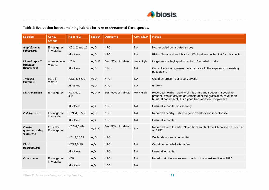
Consideration of whether habitat represents the ‘best or remaining’ 50 % of habitat for relevant significant species is
included in Section 5.
Best or remaining 50% habitat for rare and threatened flora species
Part of the assessment of conservation significance for Net Gain involves consideration of the value of habitat for
threatened species. There are 18 flora species threatened in Victoria that have at least medium likelihood of
occurrence within the site (Biosis Research 2010). Each of these species is considered in the assessment of
conservation significance.
Habitat for each species within each habitat zone is assessed against DSE’s criteria (DSE 2007, page 13). The
pathway for each decision made (in accordance Table 2 from DSE 2007) is outlined in Table 2.
3.4 Fauna
3.4.1 Habitats
Fauna habitats that occur within the site can be characterised according to vegetation communities and other
features such as waterways, rock outcrops etc.
© Biosis 2012 – Leaders in Ecology and Heritage Consulting 10
Plains grassland
Plains grassland habitat is characterised by native perennial tussock grasses and herbs growing within inter-tussock
spaces. Trees and woody shrubs are typically absent. Much of the Plains Grassland habitat on the site contains a
combination of loose surface rock and embedded rock. Plains grassland provides habitat for a diverse range of
terrestrial fauna, many of which are of national and state significance. There are a number of common bird species
that forage within plains grassland habitat, such as Australasian Pipit Anthus novaeseelandiae, Stubble Quail Coturnix
pectoralis, and Willie-wagtail Rhipidura leucophrys. Raptors also forage over these open plains grassland areas, with
species observed during the present assessment including Black-shouldered Kite Elanus axillaris and Brown
Goshawk Accipiter fasciatus. Dense tussocks and rocky areas provide suitable habitat for a number of reptiles
including Common Blue-tongue Lizard Tiliqua scincoides, Little Whip-Snake Suta flagellum, and the nationally
significant Striped Legless Lizard Delma impar. Plains grassland habitat within the study area also provides suitable
habitat for the nationally significant Golden Sun Moth Synemon plana.
Planted trees and shrubs
A small number of planted trees and shrubs exist within the study area. These are likely to be used by common
birds such as the Little Raven Corvus mellori, Magpie-lark Grallina cyanoleuca, Galah and introduced birds such as
Common Starling Sturnus vulgaris. Flowering trees and shrubs planted within the site provide additional food
resources and habitat for a number of nectar feeding birds such as Red Wattlebird Anthochaera carunculata and
White-plumed Honeyeater Lichenostomus penicillatus. Some older planted trees may also provide foraging
resources amongst fallen limbs, bark and leaf litter. These planted trees are unlikely to contain hollows.
Wetlands
Wetland habitats within the site include a small areas of plains grassy wetland either side of the Altona Railway and
an area of brackish wetland in the south-west corner of Lot H that is associated with the Laverton Creek estuary.
The areas of plains grassy wetland were dry at the time of assessment, but are prone to inundation during periods
of high rainfall. When wet, these areas may provide potential habitat for common bird species such as Masked
Lapwing Vanellus miles as well as state significant waterbirds such as Eastern Great Egret Ardea modesta. The
brackish wetland includes a small fringe of saltmarsh vegetation but is otherwise dominated by densely vegetated
Chaffy Saw-sedge. The area is contiguous with Truganina Swamp to the south-east, which is listed as a Biosite of
State Significance (Biosiste 4623). The brackish wetland provides habitat for waterbirds that prefer dense
vegetation, such as Baillon’s Crake Porzana pusilla and Australasian Bittern Botaurus poiciloptilus. Chaffy Saw-sedge
also provides a food source for the larvae of the state significant Altona Skipper, which is likely to be present within
the site.
Degraded treeless areas
This habitat type is characterised by exotic pasture grasses, weeds and dumped fill and other waste. Due to its
highly disturbed and modified nature, this habitat type contains fewer resources for fauna and consequently
species diversity is generally poor in these areas. There are large areas of dumped fill and rocky material, which
provide refuge for introduced mammals such as Red Fox Vulpes vulpes and European Rabbit Oryctolagus cuniculus.
Degraded treeless vegetation occurs immediately north of the Altona rail line and through much of the centre and
south eastern corner of the site (Figure 2).
© Biosis 2012 – Leaders in Ecology and Heritage Consulting 11
Table 2: Evaluation best/remaining habitat for rare or threatened flora species.
Species Cons.
Status
HZ (Fig 2) Steps* Outcome Con. Sig.# Notes
Amphibromus pithogastris
Endangered in Victoria
HZ 1, 2 and 11 A; D NFC NA Not recorded by targeted survey
All others A; D NFC NA Plains Grassland and Brackish Wetland are not habitat for this species
Dianella sp. aff. longifolia (Benambra)
Vulnerable in Victoria
HZ 6 A; D, F Best 50% of habitat Very High Large area of high quality habitat. Recorded on site.
All others A; D NFC NA Current site management not conducive to the expansion of existing populations
Tripogon loliiformis
Rare in Victoria
HZ3, 4, 6 & 9 A; D NFC NA Could be present but is very cryptic
All others A; D NFC NA unlikely
Diuris basaltica Endangered HZ3, 4, 6 & 9
A; D; F Best 50% of habitat Very High Recorded nearby. Quality of this grassland suggests it could be present. Would only be detectable after the grasslands have been burnt. If not present, it is a good translocation receptor site
All others A;D NFC NA Unsuitable habitat or less likely
Podolepis sp. 1 Endangered in Victoria
HZ3, 4, 6 & 9 A; D NFC NA Recorded nearby. Site is a good translocation receptor site
All others A;D NFC NA Unsuitable habitat
Pimelea spinescens subsp. spinescens
Critically Endangered
HZ 3,4,6 &9 A; B, C
Best 50% of habitat NA Recorded from the site. Noted from south of the Altona line by Frood et
al. 1997.
HZ1,2,10,11 A; D NFC Wetlands not suitable habitat
Diuris fragrantissima
HZ3,4,6 &9 A;D NFC NA Could be recorded after a fire
All others A;D NFC NA Unsuitable habitat
Cullen tenax Endangered in Victoria
HZ9 A,D NFC NA Noted in similar environment north of the Werribee line in 1997
All others A;D NFC NA

© Biosis 2012 – Leaders in Ecology and Heritage Consulting 12
Species Cons.
Status
HZ (Fig 2) Steps* Outcome Con. Sig.# Notes
Comesperm polygaloides
Vulnerable in victoria
HZ3,4,6&9 A;D, F Remaining 50% NA Noted in similar environment north of the Werribee line in 1997
All others A;D NFC NA Unsuitable habitat
Geranium sp. 3 Rare in Victoria
HZ3,4,6&9 A;D NFC NA No Geranium species recorded
All others A;D NFC NA
Saline species^ Rare in Victoria
HZ10 A;D-F Best 50% of habitat Medium Brackish Wetland is High quality habitat
All others A;D NFC NA
* Steps taken to determine best or remaining 50 % of habitat. From Table 2 in the Guide for Assessment of Referred Planning Permit Applications (DSE 2007b).
^Saline species include Salsola tragus, Atriplex paludosa, Senecio halophyllus, Triglochin minutissima, Triglochin mucronata, Juncus revolutus, Lawrencia spicata and Malva
preissiana.
HZ = Habitat Zone, NFC = No further consideration, NA = Not Applicable
# threatened species rating

© Biosis 2012 – Leaders in Ecology and Heritage Consulting 13
3.4.2 Species
A total of 28 indigenous and 7 introduced fauna species were recorded from the site during the field assessment
(Appendix 3).
Significant species
There are 63 species of state and national significance that appear on database records within 5 km of the site
(Appendix 3) or have some potential to occur based on distributional range and suitable habitat. Many of these
species are coastal or pelagic and are therefore unlikely to occur within the study area.
Twelve fauna species of national or state significance have at least a medium likelihood of occurrence within the
study area and are discussed in further detail below.
• Orange-bellied Parrot Neophema chrysogaster (EPBC listed – Nationally significant). Orange-bellied
parrots migrate from Tasmania to mainland Australia during winter, where they feed primarily within
coastal saltmarsh. The species have previously been recorded from a small number of locations within the
vicinity of the study site. There is potential for Orange-bellied Parrot to occasionally utilise the saltmarsh
and sedgeland habitat within the brackish wetland located in the south-west corner of Lot H. This area is
not considered to contain high quality or critical habitat for the species, however there is potential for
individuals to utilise the site in an unpredictable manner during the cooler months of the year.
• Striped Legless Lizard Delma impar (EPBC listed – Nationally significant). The Striped Legless Lizard is
a cryptic fossorial reptile that inhabits native and modified grasslands, where sufficient cover is available to
provide protection from predators. Until recently, suitable habitat was thought to be confined to relatively
undisturbed native grassland with good groundcover. However, recent observations have shown that this
species also can occur in substantially altered and degraded grassy environments so long as the area
retains a suitable tussock grass structure and the soil is of appropriate type, structure, and has not had
major disturbances such as ploughing. There are a small number of recent records from the local area,
and a known population occurs in the Laverton North Grasslands Reserve located approximately 1.5
kilometres north of the study site. All areas of plains grassland within the site provide potential habitat and
there is high likelihood that the species is present within these areas.
• Golden Sun Moth Synemon plana (EPBC listed – Nationally significant). The Golden Sun Moth is a
medium-sized diurnal moth that was formerly thought to be associated with grasslands that have a high
cover of native Wallaby grasses (Rytidosperma sp). However, recent surveys around Melbourne have found
that Golden Sun Moth also inhabit a range of grasslands as well as in areas supporting predominately
introduced vegetation. The species is widespread but patchily distributed in remnants of Plains Grassland
in Melbourne’s west. Golden Sun Moth were recorded immediately adjacent to Ajax Road in 2007 (Figure
3), and there are many more additional records of the species from the surrounding area. Systematic
survey for Golden Sun Moth did not detect the species the 2010/11, however, a population may still be
present. A second season of survey would provide greater certainty on whether the population has
disappeared from the site or could not be detected due to unusually wet conditions (when compared with
the past 5 years of Golden Sun Moth surveys around Melbourne).
• Lewin’s Rail Lewinia pectoralis and Baillon’s Crake Porzana pusilla (DSE Advisory List – State
Significant). Lewin’s Rail and Baillon’s Crake are small waterbirds that occupy a range of wetland habitats
with dense fringing and emergent vegetation. Densely vegetated areas within the area of brackish wetland
in Lot H provide potential habitat for the species. Reed beds within Kayes Drain and Laverton Creek also
provide habitat immediately adjacent to the study site.
© Biosis 2012 – Leaders in Ecology and Heritage Consulting 14
• Royal Spoonbill Platalea regia, Little Egret Egretta garzetta and Eastern Great Egret Ardea modesta
(DSE Advisory List – State significant). These species prefer the shallows of wetlands for foraging
activities. Occasionally they will forage in small waterways or wet grassland areas. On occasions, small
numbers of some of these species may forage within the area of plains grassy wetland within the study
area, the brackish wetland to the south-west of Lot H, and within Kayes Drain and Laverton Creek adjacent
to the site.
• Little Bittern Ixobrychus minutus (DSE Advisory List – State significant) and Australasian Bittern
Botaurus poiciloptilus (EPBC listed – Nationally significant). Little Bittern and Australasian Bittern are
typically found in terrestrial wetlands in temperate regions. These species tend to prefer permanent
freshwater wetlands surrounded by vegetation with a tall and dense structure, where individuals will
forage within shallow water associated with the edges of pools or waterways. The densely vegetated
brackish wetland in the south-west corner of Lot H, which forms the north-western corner of Truganina
Swamp, provides potential roosting habitat for these species.
• Black Falcon Falco sugniger (DSE Advisory List – State significant). This bird of prey mostly hunts over
open plains and undulating land with large tracts of low vegetation, especially in arid and semi-arid zones.
Mostly occurs in north, north-west and west of Victoria, although droughts and subsequent food shortages
can force individuals into more coastal areas. The Black Falcon is also often associated with wetland areas,
including rivers and creeks. In parts of its range the Black Falcon has probably benefited from clearing for
pasture and crops, and from the establishment of watering points. Previous records for this species exist
from within 5 km of the study area. Plains grassland within the study site provides potentially suitable
foraging habitat for Black Falcon.
• Altona Skipper Hesperilla flavescens flavescens (DSE Advisory List – State significant). The Altona
Skipper is a small butterfly that is associated with brackish sedgelands dominated by Chaffy Saw-sedge
Gahnia filum. Larvae feed almost exclusively on the leaves of G. filum plants. The species is only known
from a small number of localised sites around Melbourne, including Cherry Lake and Truganina Swamp.
The north-western corner of Truganina Swamp extends into the south-western corner of Lot H within the
study site. This area is dominated by G. filum sedges and it is therefore likely that a population of Altona
Skipper is present within the site. Further survey is required to determine the presence and distribution of
Altona Skipper within suitable habitat in Lot H.
An additional 5 species listed as near-threatened in Victoria also have potential to occur at the site (Appendix 3).
There are no policy implications for these species and they are therefore not discussed any further within this
report.
Five Latham’s Snipe Gallinago hardwickii (listed under the migratory provisions of the EPBC Act) were observed near
the study area (vacant land in Ajax Road) during targeted flora surveys in March 2011. There are other areas of
habitat for this species in the study area which could support an ecologically significant number of this species as
defined under the draft Significant Impact Guidelines for 36 Migratory Shorebirds - EPBC Policy Statement 3.21
(Commonwealth of Australia 2009). For Latham’s Snipe, important habitat is considered to be sites that:
• support at least 18 individuals of the species, and
• are naturally occurring open freshwater wetland with vegetation cover nearby (for example, tussock grasslands,
sedges, lignum or reeds within 100m of the wetland. (p11 in Commonwealth of Australia 2009).
On this basis, the south-west corner of the study area (Lot H) is of particular importance as potential habitat for
Latham’s Snipe.
© Biosis 2012 – Leaders in Ecology and Heritage Consulting 15
3.5 Further survey recommendations
The current flora survey was conducted during optimal seasonal conditions (late spring and summer during above
average rainfall conditions). This survey is one of a series of surveys conducted (Biosis Research 2006 & 2010) and
therefore it is considered that most plant species present have been identified. However some sections of the
study area were examined in mid summer and further spring surveys may identify additional species. No
additional flora surveys are proposed as the conservation significance of the site has been comprehensively
defined.
3.6 Summary of biodiversity values of the site
Key values within the site include:
• The site supports high quality remnants of two nationally significant vegetation communities: Natural
Temperate Grassland of the Victorian Volcanic Plain and Seasonal Herbaceous Wetlands (Freshwater) of
the Temperate Lowland Plains;
• A large population of one nationally threatened species, Spiny Rice-flower (489 plants);
• Populations of one species listed as vulnerable in Victoria, Arching Flax-lily (three plants) and one listed as
poorly known Flat Spike-sedge (three populations), were recorded in the study area;
• There are 34.9 ha of native vegetation including 34.8 ha of Very High conservation significance (VHCS) and
0.1 ha of High conservation significance (HCS) (NRE 2002);
• The site supports 59 plant species considered rare or restricted in the Victorian Volcanic Plain bioregion;
• The native grasslands within the study area provide potential habitat for the nationally significant fauna
species; and
• Land to the south is within a Biosite (4623) for Truganina Swamp which is of State significance.
• Habitat for national and state significant fauna species (Orange-bellied Parrot, Striped Legless Lizard,
Golden Sun Moth, Lewin’s Rail, Baillon’s Crake, Royal Spoonbill, Little Egret, Eastern Great Egret, Little
Bittern, Australasian Bittern, Black Falcon and Altona Skipper)
• Confirmed record of one insect of national conservation significance (Golden Sun Moth) within 100 m of
the study area. Although systematic surveys during the 2010-11 flight season did not detect the species, a
population may still be present
© Biosis 2012 – Leaders in Ecology and Heritage Consulting 16
4. Biodiversity Legislation and Government Policy
A guide to the Government legislation, policies and strategies relevant to the species and environments identified
during this assessment is provided in Appendix 4.
This section provides an assessment of the project against key biodiversity legislation and government policy.
4.1 Commonwealth
4.1.1 Environment Protection and Biodiversity Conservation Act 1999
The Environment Protection and Biodiversity Conservation Act 1999 (EPBC Act) applies to developments and associated
activities that have the potential to significantly impact on matters protected under the Act.
Any person proposing to take an action that may, or will, have a significant impact on a matter of National
Environmental Significance (NES) must refer the action to the Australian Government Minister for the Environment,
Heritage and the Arts for a determination of whether the action is a ‘controlled action’ or not.
Table 3 provides an assessment of the project against the EPBC Act.
Implications for the project
The site supports two threatened ecological communities (Natural Temperate Grassland of the Victorian Volcanic
Plain and Seasonal Herbaceous Wetlands (Freshwater) of the Temperate Lowland Plains community) and a
significant population of at least one listed species (489 Spiny Rice-flower – see Figure 3). A fauna assessment of the
site has also identified other matters of NES including the potential presence of an ecologically significant portion of
the population of Latham Snipe and a 2007 record of Golden Sun Moth Synemon plana adjacent to the study area
(on Ajax Road); although targeted survey in December 2010 and January 2011 did not detect the species, a
population may still be present. An assessment of the proposed impact could only be defined in response to a
finalised development plan for the site.
Given the distribution of matters of NES any development of the site is likely to require a referral under the EPBC
Act.
4.2 State
4.2.1 Flora and Fauna Guarantee Act 1988 (FFG Act)
The Flora and Fauna Guarantee Act 1988 (FFG Act) provides for the conservation of threatened species and
communities and for the management of potentially threatening processes. A permit is required from DSE to 'take'
protected flora species from public land. A permit is generally not required for removal of protected flora from
private land.
Implications for the project
Native vegetation on site is mostly an FFG listed community (Western (Basalt) Plains Grassland Community) and
also supports at least one protected plant taxon.
The land is privately owned and is not declared ‘critical habitat’. Therefore a protected flora permit is not required.
However the presence of listed threatened flora and habitat for listed threatened fauna will be considered by the
Responsible Authority in determining its response to an application for vegetation clearance under Clause 52.17
(see below).
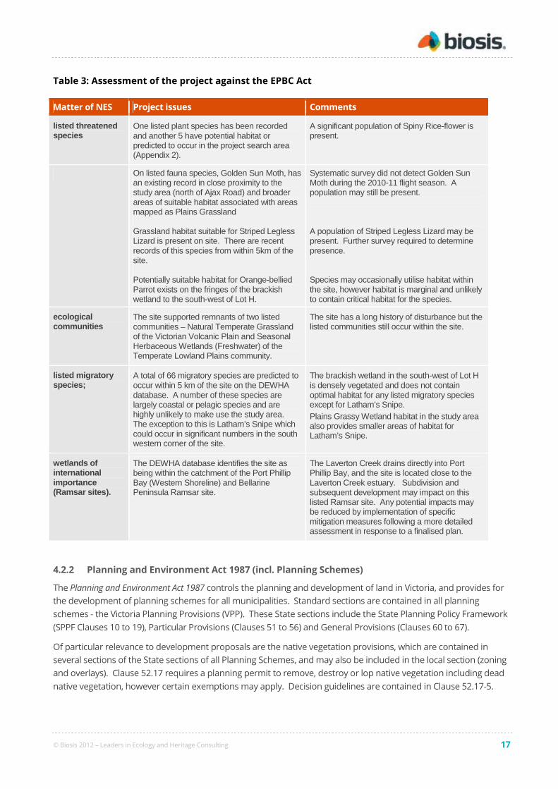
© Biosis 2012 – Leaders in Ecology and Heritage Consulting 17
Table 3: Assessment of the project against the EPBC Act
Matter of NES Project issues Comments
listed threatened species
One listed plant species has been recorded and another 5 have potential habitat or predicted to occur in the project search area (Appendix 2).
A significant population of Spiny Rice-flower is present.
On listed fauna species, Golden Sun Moth, has an existing record in close proximity to the study area (north of Ajax Road) and broader areas of suitable habitat associated with areas mapped as Plains Grassland Grassland habitat suitable for Striped Legless Lizard is present on site. There are recent records of this species from within 5km of the site. Potentially suitable habitat for Orange-bellied Parrot exists on the fringes of the brackish wetland to the south-west of Lot H.
Systematic survey did not detect Golden Sun Moth during the 2010-11 flight season. A population may still be present. A population of Striped Legless Lizard may be present. Further survey required to determine presence. Species may occasionally utilise habitat within the site, however habitat is marginal and unlikely to contain critical habitat for the species.
ecological communities
The site supported remnants of two listed communities – Natural Temperate Grassland of the Victorian Volcanic Plain and Seasonal Herbaceous Wetlands (Freshwater) of the Temperate Lowland Plains community.
The site has a long history of disturbance but the listed communities still occur within the site.
listed migratory species;
A total of 66 migratory species are predicted to occur within 5 km of the site on the DEWHA database. A number of these species are largely coastal or pelagic species and are highly unlikely to make use the study area. The exception to this is Latham’s Snipe which could occur in significant numbers in the south western corner of the site.
The brackish wetland in the south-west of Lot H is densely vegetated and does not contain optimal habitat for any listed migratory species except for Latham’s Snipe. Plains Grassy Wetland habitat in the study area also provides smaller areas of habitat for Latham’s Snipe.
wetlands of international importance (Ramsar sites).
The DEWHA database identifies the site as being within the catchment of the Port Phillip Bay (Western Shoreline) and Bellarine Peninsula Ramsar site.
The Laverton Creek drains directly into Port Phillip Bay, and the site is located close to the Laverton Creek estuary. Subdivision and subsequent development may impact on this listed Ramsar site. Any potential impacts may be reduced by implementation of specific mitigation measures following a more detailed assessment in response to a finalised plan.
4.2.2 Planning and Environment Act 1987 (incl. Planning Schemes)
The Planning and Environment Act 1987 controls the planning and development of land in Victoria, and provides for
the development of planning schemes for all municipalities. Standard sections are contained in all planning
schemes - the Victoria Planning Provisions (VPP). These State sections include the State Planning Policy Framework
(SPPF Clauses 10 to 19), Particular Provisions (Clauses 51 to 56) and General Provisions (Clauses 60 to 67).
Of particular relevance to development proposals are the native vegetation provisions, which are contained in
several sections of the State sections of all Planning Schemes, and may also be included in the local section (zoning
and overlays). Clause 52.17 requires a planning permit to remove, destroy or lop native vegetation including dead
native vegetation, however certain exemptions may apply. Decision guidelines are contained in Clause 52.17-5.

© Biosis 2012 – Leaders in Ecology and Heritage Consulting 18
The decision guidelines require the responsible authority to consider a variety of biodiversity and other information
including Net Gain policy, biodiversity values and conservation, the land protection role of native vegetation, the
quality, condition, location and significance of native vegetation and the impact of vegetation removal. The Planning
Scheme defines ‘native vegetation’ as “Plants that are indigenous to Victoria, including trees, shrubs, herbs and
grasses” (Clause 72).
The need for a permit to remove native vegetation may be also be triggered by overlays.
Implications for the project
A Planning Permit would be required from the City of Hobson’s Bay to remove or clear native vegetation within the
site (i.e. scattered occurrences of indigenous plants) as the landholding is greater than 0.4 hectares. Where
individual parcels of land support more than 0.5 ha of an endangered community (i.e. Plains Grassland) then DSE
would be a compulsory referral authority.
4.2.3 Native Vegetation Management Framework
Victoria’s Native Vegetation Management – A Framework for Action (the Framework) provides State Government policy
for the protection, enhancement and revegetation of native vegetation in Victoria (NRE 2002) and is an incorporated
document in all planning schemes. The primary goal of the Framework is:
a reversal, across the whole landscape, of the long-term decline in the extent and quality of native
vegetation, leading to a Net Gain (NRE 2002).
Where an application is made to remove native vegetation, a proponent for a development must explain the steps
that have been taken to:
• Avoid the removal of native vegetation, where possible.
• Minimise the removal of native vegetation.
• Appropriately offset the loss of native vegetation, if required.
Regional Native Vegetation Plans (e.g. PPWCMA 2006) provide a strategic and co-ordinated approach to the
management of native vegetation within a given Catchment Management Authority region, and complement the
Native Vegetation Management Framework.
Implications for the project
This report establishes the type, extent and condition of native vegetation within the site. Any proposed
development of the site would need to be assessed against the Framework once a development plan has been
prepared. A development plan would allow a net gain equation to be defined for the proposed development. As
an example for this report it is assumed that development would seek to remove all native vegetation north of the
Altona Rail Line and retain and manage all native vegetation to the south of this railway.
4.2.4 Wildlife Act 1975 and associated Regulations
The Wildlife Act 1975 is the primary legislation in Victoria providing for protection and management of wildlife.
The Wildlife Regulations 2002 of the Act prescribe penalties for certain activities relevant to wildlife including
disturbance of habitat without appropriate authorisation (Section 9).
Authorisation to destroy or possess wildlife may be required (Sections 41– 47) if wildlife needs to be moved or
destroyed during development.
Implications for the project
A permit is required to remove native vegetation at the site. If permission for removal of vegetation is granted
under provisions of other Victorian legislation a separate permit under the Wildlife Act 1975 is not required for

© Biosis 2012 – Leaders in Ecology and Heritage Consulting 19
removal of vegetation that constitutes habitat for fauna. If construction activities are likely to result in the death of
wildlife or the need to remove it, a permit will be required.
4.2.5 Water Act 1989
The primary purpose of this Act is to provide a framework for the allocation and management of surface water and
groundwater throughout Victoria. It provides a principal mechanism for maintenance of ecosystem functions
including those of aquatic ecosystems. Any construction or maintenance activity that affects beds and banks of
waterways, riparian vegetation, quality or quantity of water, requires a licence, permit or approval from the relevant
authority.
The relevant authority for the proposal is Melbourne Water.
Implications for the project
Any large scale development of the site would incorporate works on waterways associated with stormwater
facilities and requires approval from Melbourne Water via an Agreement process set out in their Land Development
Manual (http://ldm.melbournewater.com.au/content/introduction/introduction.asp).
4.2.6 Environment Protection Act 1970: State Environmental Protection Policy (Waters of Victoria)
2003
The Environment Protection Act underpins the State Environmental Protection Policies (SEPP) which provides a legal
framework for the protection and rehabilitation of Victoria’s surface water environments. The uses and values of
the water environment are known as ‘beneficial uses’. Environmental quality objectives and indicators are defined
to protect beneficial uses and an attainment program provides guidance on protection of the beneficial uses. The
key beneficial use of relevance to biodiversity is ‘Aquatic ecosystems’. The Policy requires that aquatic ecosystems
be protected.
Impacts to surface water quality must not result in changes that exceed water quality objectives specified to protect
beneficial uses. Proponents and land managers need to ensure that direct and indirect (e.g. runoff) impacts to
surface water quality do not exceed the water quality objectives.
The SEPP provides recommendations to ensure that beneficial uses are protected.
Implications for the project
The project may directly and/or indirectly impact upon the Laverton Creek and Truganina Swamp and their
associated aquatic ecosystems. Relevant actions identified in the applicable policy clauses have been incorporated
into any mitigation measures (Section 6).
4.2.7 Regional Catchment Strategy and River Health Strategy
State Planning Policy Framework Clause 15.01 (Protection of catchments, waterways and groundwater) states that
planning and responsible authorities must have regard for the objectives of the Port Phillip and Westernport Regional
Catchment Strategy (PPWCMA, 2004). The Port Phillip and Westernport Regional River Health Strategy (PPWCMA,
Melbourne Water 2007) provides further recommendations on the protection of existing high-value rivers and
creeks that are in good condition and strategic improvement of other rivers and creeks
Implications for the project
The key biodiversity objectives of the above Strategies with respect to the aquatic environment will be met if the
mitigation measures outlined in this report are complied with.
Laverton Creek is considered to be of very high regional importance. It is currently in poor condition but is
earmarked for a range of management initiatives to improve the condition to moderate.
© Biosis 2012 – Leaders in Ecology and Heritage Consulting 20
5. Victoria’s Native Vegetation Management Framework
(Net Gain)
5.1 Quantifying native vegetation on site
Patches of remnant vegetation were mapped and assessed (Figure 2). Areas of uniform quality for each EVC within
the patches are termed ‘habitat zones’ and each habitat zone is assessed separately.
All remaining areas that are not EVC patches or scattered remnant canopy trees are termed Degraded Treeless
Vegetation (DTV; DSE 2007b).
The EVC benchmarks for Plains Grassland, Plains Grassy Wetland and Brackish Wetland are provided in Appendix 5.
5.1.1 Patches of native vegetation
Each habitat zone is assessed in terms of habitat hectares. A total of 9 habitat zones (or polygons) are identified
(Figure 2). The results of the vegetation quality assessment are provided in Table 4. Each habitat zone is assigned
an overall habitat score, which is multiplied by its area to provide the number of habitat hectares. The conservation
significance of each zone is also shown at the bottom of and this is discussed more in the following section.
Conservation significance for threatened species
Part of the assessment of conservation significance involves consideration of the value of habitat for threatened
species. There are 27 significant species (flora and fauna) that have at least medium likelihood of occurrence within
the site and the conservation significance of each habitat zone for each of these species is determined in Sections
3.3.2 and 3.4.2.
The overall threatened species rating for each habitat zone is given by the highest threatened species rating scored
for any one species. This result is presented in Table 4.
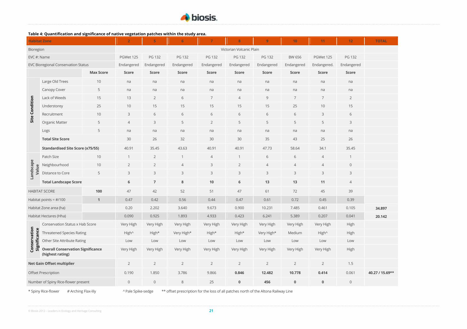
© Biosis 2012 – Leaders in Ecology and Heritage Consulting 21
Table 4: Quantification and significance of native vegetation patches within the study area.
Habitat Zone 2 5 6 7 8 9 10 11 12 TOTAL
Bioregion Victorian Volcanic Plain
EVC #: Name PGWet 125 PG 132 PG 132 PG 132 PG 132 PG 132 BW 656 PGWet 125 PG 132
EVC Bioregional Conservation Status Endangered Endangered Endangered Endangered Endangered Endangered Endangered Endangered. Endangered
Max Score Score Score Score Score Score Score Score Score Score
Sit
e C
on
dit
ion
Large Old Trees 10 na na na na na na na na na
Canopy Cover 5 na na na na na na na na na
Lack of Weeds 15 13 2 6 7 4 9 7 7 2
Understorey 25 10 15 15 15 15 15 25 10 15
Recruitment 10 3 6 6 6 6 6 6 3 6
Organic Matter 5 4 3 5 2 5 5 5 5 3
Logs 5 na na na na na na na na na
Total Site Score 30 26 32 30 30 35 43 25 26
Standardised Site Score (x75/55) 40.91 35.45 43.63 40.91 40.91 47.73 58.64 34.1 35.45
La
nd
sca
pe
Va
lue
Patch Size 10 1 2 1 4 1 6 6 4 1
Neighbourhood 10 2 2 4 3 2 4 4 4 0
Distance to Core 5 3 3 3 3 3 3 3 3 3
Total Landscape Score 6 7 8 10 6 13 13 11 4
HABITAT SCORE 100 47 42 52 51 47 61 72 45 39
Habitat points = #/100 1 0.47 0.42 0.56 0.44 0.47 0.61 0.72 0.45 0.39
Habitat Zone area (ha) 0.20 2.202 3.640 9.673 0.900 10.231 7.485 0.461 0.105 34.897
Habitat Hectares (Hha) 0.090 0.925 1.893 4.933 0.423 6.241 5.389 0.207 0.041 20.142
Co
nse
rva
tio
n
Sig
nif
ica
nce
Conservation Status x Hab Score Very High Very High Very High Very High Very High Very High Very High Very High High
Threatened Species Rating High^ High* Very High* High* High* Very High* Medium High^ High
Other Site Attribute Rating Low Low Low Low Low Low Low Low Low
Overall Conservation Significance
(highest rating)
Very High Very High Very High Very High Very High Very High Very High Very High High
Net Gain Offset multiplier 2 2 2 2 2 2 2 2 1.5
Offset Prescription 0.190 1.850 3.786 9.866 0.846 12.482 10.778 0.414 0.061 40.27 / 15.69**
Number of Spiny Rice-flower present 0 0 8 25 0 456 0 0 0
* Spiny Rice-flower # Arching Flax-lily ^ Pale Spike-sedge ** offset prescription for the loss of all patches north of the Altona Railway Line
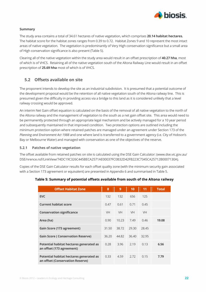
© Biosis 2012 – Leaders in Ecology and Heritage Consulting 22
Summary
The study area contains a total of 34.61 hectares of native vegetation, which comprises 20.14 habitat hectares.
The habitat score for the habitat zones ranges from 0.39 to 0.72. Habitat Zones 9 and 10 represent the most intact
areas of native vegetation. The vegetation is predominantly of Very High conservation significance but a small area
of High conservation significance is also present (Table 5).
Clearing all of the native vegetation within the study area would result in an offset prescription of 40.27 hha, most
of which is of VHCS. Retaining all of the native vegetation south of the Altona Railway Line would result in an offset
prescription of 25.69 hha most of which is of VHCS.
5.2 Offsets available on site
The proponent intends to develop the site as an industrial subdivision. It is presumed that a potential outcome of
the development proposal would be the retention of all native vegetation south of the Altona railway line. This is
presumed given the difficulty in providing access via a bridge to this land as it is considered unlikely that a level
railway crossing would be approved.
An interim Net Gain offset equation is calculated on the basis of the removal of all native vegetation to the north of
the Altona railway and the management of vegetation to the south as a net gain offset site. This area would need to
be permanently protected through an appropriate legal mechanism and be actively managed for a 10 year period
and subsequently maintained in that improved condition. Two protection options are outlined including the
minimum protection option where retained patches are managed under an agreement under Section 173 of the
Planning and Environment Act 1988 and one where land is transferred to a government agency (i.e. City of Hobson’s
Bay or Melbourne Water) and managed with conservation as one of the objectives of the reserve.
5.2.1 Patches of native vegetation
The offset available from retained patches on site is calculated using the DSE Gain Calculator: (www.dse.vic.gov.au/
DSE/nrence.nsf/LinkView/74DC19C326C445BECA2571AE00037FC0B32D42FB223C7345CA25712B0007130A).
Copies of the DSE Gain Calculator results for each offset quality zone (with the minimum security gain associated
with a Section 173 agreement or equivalent) are presented in Appendix 6 and summarised in Table 5.
Table 5: Summary of potential offsets available from south of the Altona railway
Offset Habitat Zone 8 9 10 11 Total
EVC 132 132 656 125
Current habitat score 0.47 0.61 0.71 0.45
Conservation significance VH VH VH VH
Area (ha) 0.90 10.23 7.49 0.46 19.08
Gain Score (173 agreement) 31.50 38.72 29.30 28.45
Gain Score ( Conservation Reserve) 36.20 44.82 36.40 32.95
Potential habitat hectares generated as
an offset (173 agreement)
0.28 3.96 2.19 0.13 6.56
Potential habitat hectares generated as
an offset (Conservation Reserve)
0.33 4.59 2.72 0.15 7.79

© Biosis 2012 – Leaders in Ecology and Heritage Consulting 23
5.3 Summary of net gain offsets
In summary, a total offset of 6.56 habitat hectares could be generated through management of vegetation on site
and protection under a s. 173 agreement (or equivalent). This increases to an offset potential of 7.79 hha if the land
was transferred to a conservation reserve.
However the like-for-like requirements indicate that the available offsets cannot be fully utilised to offset the losses
associated with this development. While areas of VHCS Brackish Wetland can provide offsets for the loss of HCS
Plains Grassland they cannot provide offsets for the loss of VHCS Plains Grassland.
Based on the like-for-like requirements, utilising the offsets available from south of the Altona Railway Line
(presuming a transfer to a government authority and management with conservation as one of the management
objectives) this reserve would supply an excess gain of 2.67 hha of VHCS Brackish Wetland and have a deficit of
0.04 hha of VHCS Plains Grassy Wetland and 10.58 hha of VHCS Plains Grassland.
The proponent is responsible for protection and the first 10 years of management of offset sites. An Offset
Management Plan should be developed for any Net Gain offset sites.
© Biosis 2012 – Leaders in Ecology and Heritage Consulting 24
6. Recommendations to Minimise Impacts
The biodiversity values identified in the flora and fauna assessment should be considered during the design phase
of the project.
The primary measure to minimise impacts to biodiversity values on the site is to minimise removal of native
vegetation and habitats. To retain these values they need to be avoided in the design process and protected and
managed in designated reserves.
Development of the area north of the Altona railway line will result in the loss of Plains Grassland and Plains Grassy
Wetland. The offset requirements for these losses are provided in Section 5. Retaining the area south of the
railway line and using it as a net gain offset site will protect areas of Brackish Wetland, Plains Grassy Wetland and
Plains Grassland. This area also supports a substantial population of Spiny Rice-flower. The area is contiguous with
Truganina Swamp to the south-east, which is listed as a Biosite of State Significance (Biosiste 4623).
Measures to minimise impacts of development on ecological values of the study area include:
Design and pre-construction
• Protect all areas to be retained by means of temporary fencing. Fencing must be installed before
construction work commences.
• Retain fauna habitat linkages within the development and the local area e.g. Laverton Creek/Kayes Drain
corridor
• Make allowance within the development footprint for all construction works (including construction vehicle
access, road batters, footpaths and all services) so all areas outside the development area (particularly
reserves) be treated as no-go zones.
• Incorporate relevant Water Sensitive Urban Design (WSUD) and Water Sensitive Road Design (WSRD)
(Wong et al. 2000) elements such as porous pavements, swale drains, buffer strips, flow
detention/retention by infiltration and treatment wetlands/ponds, wherever practical/appropriate.
• Minimise the removal of native vegetation within or adjacent to waterbodies and watercourses. Protect
waterways by inclusion of appropriate buffers into design.
• Design any stormwater treatment wetlands to provide fauna habitat. Suitable habitat features include
shelter and basking sites (i.e. rocks and logs), fringing emergent aquatic vegetation and submerged aquatic
vegetation.
• Monitor water quality within any constructed wetlands and within receiving waterways (Laverton Creek and
Truganina Swamp) at a number of sites upstream and downstream of the discharge point. This should be
conducted as part of an appropriate water quality monitoring program, developed with input from a
specialist aquatic ecologist.
• Ensure all environmental constraints are clearly communicated to construction personnel and
incorporated into the workforce induction program and a site Construction Management Plan.
• Carefully design any landscape plantings in the vicinity of any conservation reserves. Issues to consider
include species’ invasiveness, genetic pollution and shading of indigenous grasslands. Landscape plantings
that are intended to enhance ecological values must consist of species of local provenance.
© Biosis 2012 – Leaders in Ecology and Heritage Consulting 25
Construction
• Keep the construction footprint to a minimum.
• Protect areas of retained native vegetation and areas of environmental sensitivity. These areas should be
fenced and treated as no-go zones.
• Prevent access to no-go zones – including vehicles, construction personnel, equipment and stockpiles.
• The construction zone should incorporate appropriate buffer distances from waterways or associated
waterbodies (including floodplains) wherever practicable;
• Install effective sediment control measures to protect waterbodies, retained native vegetation and habitat.
• Manage construction works to minimise discharge of sediments and other pollutants. Suitable measures
are provided in Environmental Guidelines for Major Construction Sites (EPA 1996, amended) and Construction
Techniques for Sediment Pollution Control (EPA 1991) and Guideline for Environmental Management. Doing it
right on subdivisions. Temporary environmental protection measures for subdivision construction sites. (EPA
2004).
• Refuelling of vehicles and storage of chemicals and other equipment should occur on stable surfaces and
should not occur within 30-50 m of a waterway or associated waterbodies and should not occur within a
floodplain or land subject to inundation;
• All protective fencing must be maintained in good repair throughout construction.
• All sediment control measures must be maintained in good repair and regularly inspected to ensure
adequate performance throughout construction.
• Avoid operational discharges to waterways. If such discharges cannot be avoided they should be
minimised through water re-use and recycling. Discharges should be monitored to assess the protection
of beneficial uses.
Post-construction
• Develop and implement management plan to retain/enhance biodiversity values of conservation reserves.
• Site rehabilitation/revegetation.
© Biosis 2012 – Leaders in Ecology and Heritage Consulting 26
References DEH 2006. EPBC Act Policy Statement 1.1 Significant Impact Guidelines: Matters of National
Environmental Significance. Department of Environment and Heritage, Australian Government,
Canberra.
DSE 2004. Native Vegetation: Sustaining a living landscape. Vegetation Quality Assessment Manual –
Guidelines for applying the habitat hectares scoring method. Version 1.3. Department of
Sustainability and Environment, Melbourne.
DSE 2005. Biosites Maps and Reports, Port Phillip Region (CD). Department of Sustainability and
Environment, Melbourne.
DSE 2006b. Vegetation Gain Approach – Technical basis for calculating gains through improved native
vegetation management and revegetation. Victorian Government, Department of Sustainability
and Environment, East Melbourne.
DSE 2007b. Native Vegetation - Guide for assessment of referred planning permit applications. Victorian
Government, Department of Sustainability and Environment, East Melbourne.
EPA, 1991. Construction Techniques for Sediment Pollution Control. Publication 275, Environment
Protection Authority Victoria, Melbourne.
EPA, 1996. Environmental Guidelines for Major Construction Sites. Publication 480, Environment
Protection Authority Victoria, Melbourne.
EPA 2004. Publication 960, Guideline for Environmental Management. Doing it right on subdivisions.
Temporary environmental protection measures for subdivision construction sites. Environment
Protection Agency, Melbourne.
Frood, D., Robertson, P. & Ellery W. 1997. ‘Burns Road Environs. A Site Assessment for Flora and
Fauna.’ Report to the Department of Natural Resources and Environment by Envirosol
International Pty Ltd. May 1997.
IUCN 2001. IUCN Red List Categories and Criteria: Version 3.1. IUCN Species Survival Commission,
International Union for Conservation of Nature & Natural Resources, Gland, Switzerland and
Cambridge, UK.
NRE 2002. Victoria's Native Vegetation Management: A Framework for Action. Department of Natural
Resources & Environment, Victoria.
PPWCMA, 2004. Port Phillip and Westernport Regional Catchment Strategy. Port Phillip and
Westernport Catchment Management Authority
PPWCMA 2006. Port Phillip and Westernport Native Vegetation Plan. Port Phillip and Westernport
Catchment Management Authority, Frankston, Victoria.
Walsh, N.G. & Stajsic, V. 2007. A Census of the Vascular Plants of Victoria. Eighth edition, Royal Botanic
Gardens Melbourne.
Walsh, N.G. & Entwisle, V. 1996. Flora of Victoria. Volume 3, Dicotyledons, Winteraceae to Myrtaceae.
Inkata Press, Melbourne.
Walsh, N.G. & Entwisle, V. 1999. Flora of Victoria. Volume 4, Dicotyledons, Cornaceae to Asteraceae.
Inkata Press, Melbourne.
Walsh, N.G. & Stajsic, V. 2008. A Census of the Vascular Plants of Victoria. Eighth edition, Royal Botanic
Gardens Melbourne.

© Biosis 2012 – Leaders in Ecology and Heritage Consulting 27
Appendices

© Biosis 2012 – Leaders in Ecology and Heritage Consulting 28
Appendix 1: Sources of Criteria for Significance
The common language meaning of significance is ‘importance; consequence’ (Macquarie Dictionary). While
the general meaning of this is clear, the term is further defined in ecological significance assessment.
Following is a list of the information sources used in this report that provide advice on significance of flora and
fauna species and communities.
A1.1 Species and Communities
• A taxon or community has national significance when it is listed as threatened (critically endangered,
endangered, vulnerable or conservation dependent) under the Environment Protection and Biodiversity
Conservation Act 1999.
• A taxon has national significance when it is listed as rare in Australia (R) in A Census of the Vascular
Plants of Victoria (Walsh & Stajsic 2008).
• A taxon or community has state significance when it is listed as threatened under the Flora and Fauna
Guarantee Act 1988.
• A taxon or community has state significance when it is listed as threatened (critically endangered,
endangered or vulnerable) or near threatened, rare, data deficient or poorly known in Victoria on a DSE
Advisory List (DSE 2005, 2007a ).
• A taxon or community also has national or state significance when it is considered to be threatened at that
level by Biosis Research using IUCN criteria (IUCN 2001).
• Biosis Research considers flora species to have significance at the bioregional level when they are
recorded from a small percentage of records in the bioregion, as follows:
Threshold for bioregional significance
Bioregions
< 1% of records in the bioregion (bioregions that support more remnant vegetation)
Bridgewater East Gippsland Lowlands East Gippsland Uplands Greater Grampians Highlands – Far East Highlands – Northern Fall
Highlands – Southern Fall Lowan Mallee Otway Ranges Victorian Alps Wilsons Promontory
< 5% of records in the bioregion (bioregions that have been more cleared)
Central Victorian Uplands Dundas Tablelands Gippsland Plain Glenelg Plain Goldfields Monaro Tablelands Murray Fans Murray Mallee Murray Scroll Belt
Northern Inland Slopes Otway Plain Robinvale Plain Strzelecki Ranges Victorian Riverina Victorian Volcanic Plain Warrnambool Plain Wimmera

© Biosis 2012 – Leaders in Ecology and Heritage Consulting 29
A1.2 Sites
• Patches of native vegetation have conservation significance (very high, high, medium or low) according to
the criteria for significance in Victoria’s Native Vegetation Management – A Framework for Action
(NRE 2002). This assessment is calculated at the bioregional scale.
• Areas of conservation significance are documented in the DSE Victorian biosite database. The database
rates sites as significant at national, state and regional levels. These ratings are undertaken at varying
geographic scales and are thus not directly comparable to the categories defined by the Framework (NRE
2002).

© Biosis 2012 – Leaders in Ecology and Heritage Consulting 30
Appendix 2: Flora Results
A2.1 Flora species recorded from study area
Australian status: C Critically endangered (EPBC Act)
Victorian status: e endangered (FIS)
v vulnerable (FIS)
k Poorly known (FIS)
2010/11: Species recorded during current survey (FIS Lists T25141)
Species uncommon in the bioregion (recorded from less than 1% of sites) are labelled R (56 species)
Table A2.1. Flora species (109 Native, 81 weeds) recorded from the study area
Species Common Name
Rare or Threatened Native Species
v Dianella sp. aff. longifolia (Benambra) Arching Flax-lily
k Eleocharis pallens Pale Spike-sedge
Ce Pimelea spinescens subsp. spinescens Spiny Rice-flower
Native Species
Acacia pycnantha Golden Wattle
Acaena echinata Sheep's Burr
Alisma plantago-aquatica Water Plantain
Amphibromus nervosus Common Swamp Wallaby-grass
Anthosachne scabra Common Wheat-grass
Apium annuum Annual Celery
Asperula conferta Common Woodruff
Atriplex semibaccata Berry Saltbush
Austrostipa bigeniculata Kneed Spear-grass
Austrostipa curticoma Short-crown Spear-grass
Austrostipa gibbosa Spurred Spear-grass
Austrostipa oligostachya Fine-head Spear-grass
Bolboschoenus caldwellii Salt Club-sedge
Bothriochloa macra Red-leg Grass
Brachyscome dentata Lobe-seed Daisy
Caesia calliantha Blue Grass-lily
Calocephalus citreus Lemon Beauty-heads
Calocephalus lacteus Milky Beauty-heads
Cassinia arcuata Drooping Cassinia
Cheilanthes austrotenuifolia Green Rock-fern
Chloris truncata Windmill Grass
Convolvulus angustissimus var. omnigracilis Blushing Bindweed
Crassula decumbens var. decumbens Spreading Crassula
Crassula sieberiana Sieber Crassula
Damasonium minus Star Fruit
Dianella brevicaulis Small-flower Flax-lily
Dianella revoluta var. revoluta Black-anther Flax-lily

© Biosis 2012 – Leaders in Ecology and Heritage Consulting 31
Species Common Name
Native Species (cont.)
Dichelachne crinita Long-hair Plume-grass
Dichondra repens Kidney-weed
Dillwynia cinerascens Grey Parrot-pea
Disphyma crassifolium subsp. clavellatum Rounded Noon-flower
Distichlis distichophylla Australian Salt-grass
Dodonaea viscosa subsp. spatulata Sticky Hop-bush
Einadia nutans subsp. nutans Nodding Saltbush
Eleocharis pusilla Small Spike-sedge
Enchylaena tomentosa var. tomentosa Ruby Saltbush
Eriochloa pseudoacrotricha Early Spring-grass
Eryngium ovinum Blue Devil
Eryngium vesiculosum Prickfoot
Euchiton collinus Creeping Cudweed
Euchiton involucratus Star Cudweed
Eutaxia microphylla var. microphylla Common Eutaxia
Ficinia nodosa Knobby Club-sedge
Gahnia filum Chaffy Saw-sedge
Geranium retrorsum Grassland Crane's-bill
Glycine tabicina Variable Glycine
Goodenia pinnatifida Cut-leaf Goodenia
Haloragis heterophylla Varied Raspwort
Halosarcia pergranulata Blackseed Glasswort
Hypericum gramineum Small St John's Wort
Hypoxis glabella var. glabella Tiny Star
Isolepis cernua var. cernua Nodding Club-sedge
Isolepis cernua var. platycarpa Nodding Club-sedge
Isolepis hookeriana Grassy Club-sedge
Isolepis victoriensis Victorian Club-sedge
Juncus amabilis Hollow Rush
Juncus bufonius Toad Rush
Juncus kraussii subsp. australiensis Sea Rush Juncus subsecundus Finger Rush
Lachnagrostis aemula Purplish Blown-grass
Lachnagrostis filiformis Common Blown-grass
Linum marginale Native Flax
Lobelia irrigua Salt Pratia
Lomandra longifolia Spiny-headed Mat-rush
Lomandra micrantha Small-flower Mat-rush
Lomandra nana Dwarf Mat-rush
Lythrum hyssopifolia Small Loosestrife
Maireana decalvans Black Cotton-bush
Microlaena stipoides var. stipoides Weeping Grass
Oxalis perennans Grassland Wood-sorrel
Panicum decompositum var. decompositum Native Millet
Panicum effusum Hairy Panic
Phragmites australis Common Reed
Pimelea curviflora Curved Rice-flower
Pimelea glauca Smooth Rice-flower
Plantago gaudichaudii Narrow Plantain
Poa labillardierei var. (Volcanic Plains) Basalt Tussock-grass
© Biosis 2012 – Leaders in Ecology and Heritage Consulting 32
Species Common Name
Native Species (cont.)
Poa poiformis Coast Tussock-grass
Poa sieberiana var. sieberiana Grey Tussock-grass
Pseudognaphalium luteoalbum Jersey Cudweed
Ptilotus macrocephalus Feather Heads
Rhagodia candolleana subsp. candolleana Seaberry Saltbush
Rumex brownii Slender Dock
Rumex dumosus Wiry Dock
Rytidosperma auriculata Lobed Wallaby-grass
Rytidosperma caespitosa Common Wallaby-grass
Rytidosperma carphoides Short Wallaby-grass
Rytidosperma duttoniana Brown-back Wallaby-grass
Rytidosperma eriantha Hill Wallaby-grass
Rytidosperma fulva Copper-awned Wallaby-grass
Rytidosperma setacea Bristly Wallaby-grass
Samolus repens Creeping Brookweed
Sarcocornia quinqueflora Beaded Glasswort
Schoenus apogon Common Bog-sedge
Schoenus nitens Shiny Bog-sedge
Selliera radicans Shiny Swamp-mat
Senecio quadridentatus Cotton Fireweed
Solenogyne dominii Smooth Solenogyne
Stackhousia subterranea Plains Stackhousia
Suaeda australis Austral Seablite
Themeda triandra Kangaroo Grass
Tricoryne elatior Yellow Rush-lily
Velleia paradoxa Spur Velleia
Veronica gracilis Slender Speedwell
Wahlenbergia luteola Bronze Bluebell
Walwhalleya proluta Rigid Panic
Wilsonia rotundifolia Round-leaf Wilsonia
Introduced Species
Acacia spp. Wattle (naturalised)
Agapanthus praecox subsp. orientalis Agapanthus
Anthoxanthum odoratum Sweet Vernal-grass
Arctotheca calendula Cape Weed
Aster subulatus Aster-weed
Atriplex prostrata Hastate Orache
Avena barbata Bearded Oat
Avena sterilis Sterile Oat
Berkheya rigida African Thistle
Brassica fruticulosa Twiggy Turnip
Briza maxima Large Quaking-grass
Briza minor Lesser Quaking-grass
Bromus catharticus Prairie Grass
Bromus hordeaceus subsp. hordeaceus Soft Brome
Catapodium rigidum Fern Grass
Cenchrus clandestinus Kikuyu
Centaurium erythraea Common Centaury
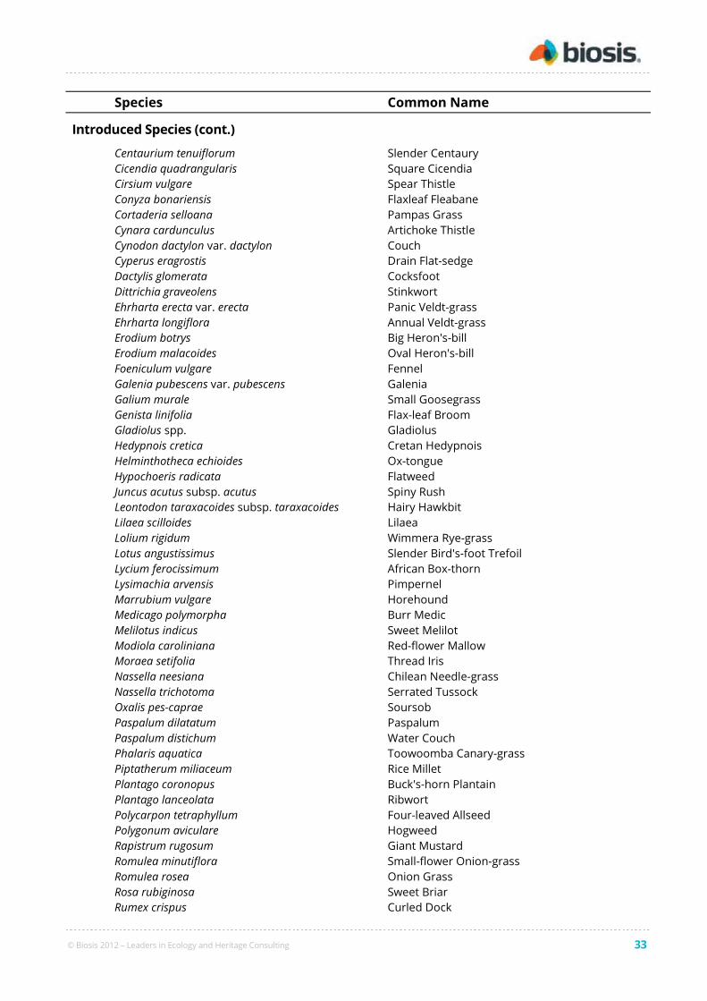
© Biosis 2012 – Leaders in Ecology and Heritage Consulting 33
Species Common Name
Introduced Species (cont.)
Centaurium tenuiflorum Slender Centaury
Cicendia quadrangularis Square Cicendia
Cirsium vulgare Spear Thistle
Conyza bonariensis Flaxleaf Fleabane
Cortaderia selloana Pampas Grass
Cynara cardunculus Artichoke Thistle
Cynodon dactylon var. dactylon Couch
Cyperus eragrostis Drain Flat-sedge
Dactylis glomerata Cocksfoot
Dittrichia graveolens Stinkwort
Ehrharta erecta var. erecta Panic Veldt-grass
Ehrharta longiflora Annual Veldt-grass
Erodium botrys Big Heron's-bill
Erodium malacoides Oval Heron's-bill
Foeniculum vulgare Fennel
Galenia pubescens var. pubescens Galenia
Galium murale Small Goosegrass
Genista linifolia Flax-leaf Broom
Gladiolus spp. Gladiolus
Hedypnois cretica Cretan Hedypnois
Helminthotheca echioides Ox-tongue
Hypochoeris radicata Flatweed
Juncus acutus subsp. acutus Spiny Rush
Leontodon taraxacoides subsp. taraxacoides Hairy Hawkbit
Lilaea scilloides Lilaea
Lolium rigidum Wimmera Rye-grass
Lotus angustissimus Slender Bird's-foot Trefoil
Lycium ferocissimum African Box-thorn
Lysimachia arvensis Pimpernel
Marrubium vulgare Horehound
Medicago polymorpha Burr Medic
Melilotus indicus Sweet Melilot
Modiola caroliniana Red-flower Mallow
Moraea setifolia Thread Iris
Nassella neesiana Chilean Needle-grass
Nassella trichotoma Serrated Tussock
Oxalis pes-caprae Soursob
Paspalum dilatatum Paspalum
Paspalum distichum Water Couch
Phalaris aquatica Toowoomba Canary-grass
Piptatherum miliaceum Rice Millet
Plantago coronopus Buck's-horn Plantain
Plantago lanceolata Ribwort
Polycarpon tetraphyllum Four-leaved Allseed
Polygonum aviculare Hogweed
Rapistrum rugosum Giant Mustard
Romulea minutiflora Small-flower Onion-grass
Romulea rosea Onion Grass
Rosa rubiginosa Sweet Briar
Rumex crispus Curled Dock

© Biosis 2012 – Leaders in Ecology and Heritage Consulting 34
Species Common Name
Introduced Species (cont.)
Setaria parviflora Slender Pigeon Grass
Solanum nigrum Black Nightshade
Sonchus asper Rough Sow-thistle
Sonchus oleraceus Common Sow-thistle
Spergularia media Greater Sea-spurrey
Sporobolus africanus Rat-tail Grass
Tribolium acutiflorum Crested Desmazeria
Trifolium angustifolium var. angustifolium Narrow-leaf Clover
Trifolium campestre var. campestre Hop Clover
Trifolium dubium Suckling Clover
Trifolium glomeratum Cluster Clover
Ulex europaeus Gorse
Vicia sativa Common Vetch
Vulpia bromoides Squirrel-tail Fescue
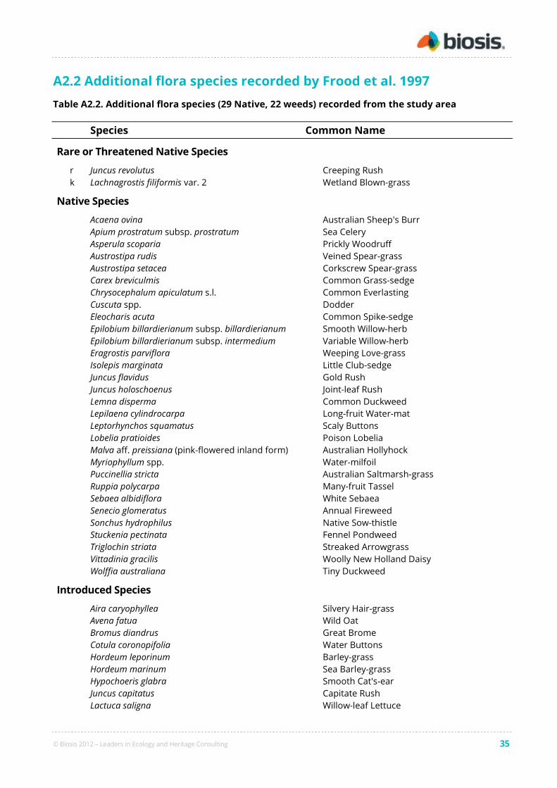
© Biosis 2012 – Leaders in Ecology and Heritage Consulting 35
A2.2 Additional flora species recorded by Frood et al. 1997
Table A2.2. Additional flora species (29 Native, 22 weeds) recorded from the study area
Species Common Name
Rare or Threatened Native Species
r Juncus revolutus Creeping Rush
k Lachnagrostis filiformis var. 2 Wetland Blown-grass
Native Species
Acaena ovina Australian Sheep's Burr
Apium prostratum subsp. prostratum Sea Celery
Asperula scoparia Prickly Woodruff
Austrostipa rudis Veined Spear-grass
Austrostipa setacea Corkscrew Spear-grass
Carex breviculmis Common Grass-sedge
Chrysocephalum apiculatum s.l. Common Everlasting
Cuscuta spp. Dodder
Eleocharis acuta Common Spike-sedge
Epilobium billardierianum subsp. billardierianum Smooth Willow-herb
Epilobium billardierianum subsp. intermedium Variable Willow-herb
Eragrostis parviflora Weeping Love-grass
Isolepis marginata Little Club-sedge
Juncus flavidus Gold Rush
Juncus holoschoenus Joint-leaf Rush
Lemna disperma Common Duckweed
Lepilaena cylindrocarpa Long-fruit Water-mat
Leptorhynchos squamatus Scaly Buttons
Lobelia pratioides Poison Lobelia
Malva aff. preissiana (pink-flowered inland form) Australian Hollyhock
Myriophyllum spp. Water-milfoil
Puccinellia stricta Australian Saltmarsh-grass
Ruppia polycarpa Many-fruit Tassel
Sebaea albidiflora White Sebaea
Senecio glomeratus Annual Fireweed
Sonchus hydrophilus Native Sow-thistle
Stuckenia pectinata Fennel Pondweed
Triglochin striata Streaked Arrowgrass
Vittadinia gracilis Woolly New Holland Daisy
Wolffia australiana Tiny Duckweed
Introduced Species
Aira caryophyllea Silvery Hair-grass
Avena fatua Wild Oat
Bromus diandrus Great Brome
Cotula coronopifolia Water Buttons
Hordeum leporinum Barley-grass
Hordeum marinum Sea Barley-grass
Hypochoeris glabra Smooth Cat's-ear
Juncus capitatus Capitate Rush
Lactuca saligna Willow-leaf Lettuce
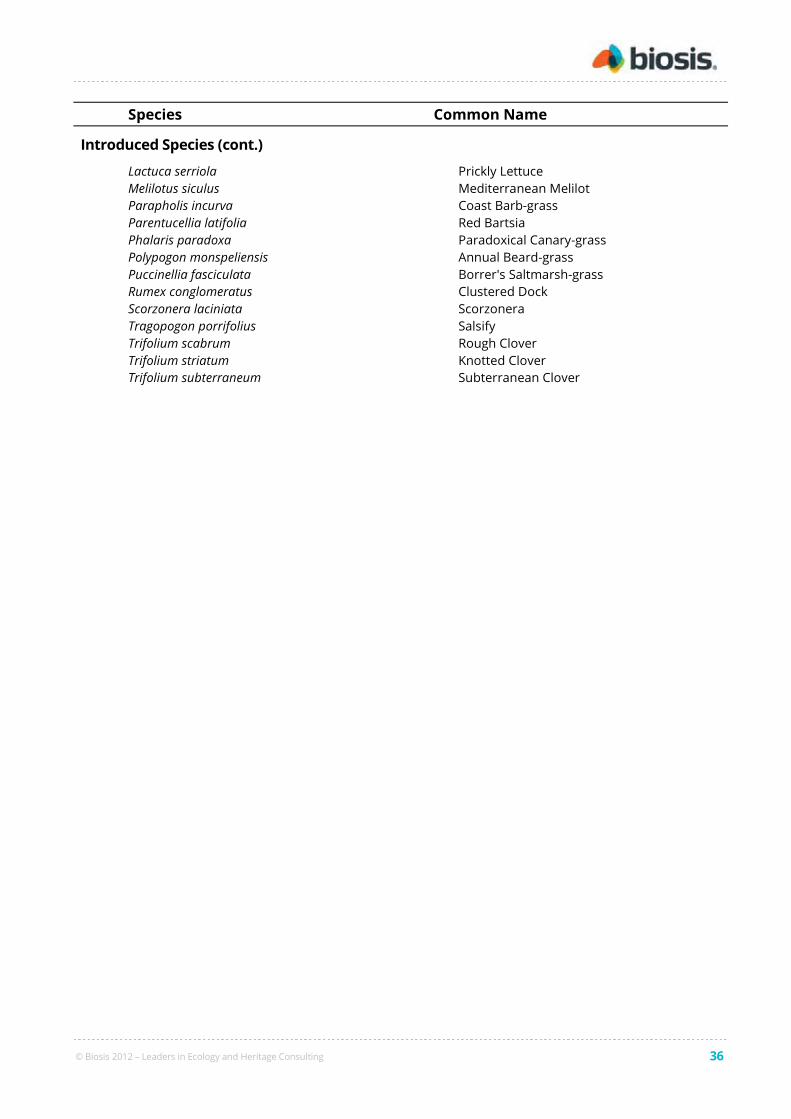
© Biosis 2012 – Leaders in Ecology and Heritage Consulting 36
Species Common Name
Introduced Species (cont.)
Lactuca serriola Prickly Lettuce
Melilotus siculus Mediterranean Melilot
Parapholis incurva Coast Barb-grass
Parentucellia latifolia Red Bartsia
Phalaris paradoxa Paradoxical Canary-grass
Polypogon monspeliensis Annual Beard-grass
Puccinellia fasciculata Borrer's Saltmarsh-grass
Rumex conglomeratus Clustered Dock
Scorzonera laciniata Scorzonera
Tragopogon porrifolius Salsify
Trifolium scabrum Rough Clover
Trifolium striatum Knotted Clover
Trifolium subterraneum Subterranean Clover

© Biosis 2012 – Leaders in Ecology and Heritage Consulting 37
A2.3 Significant flora species
Includes national and state significant species from the following sources:
• DSE Flora Information System 2007 Version
• DEWHA database (PMST accessed on 01.05.10)
• Current survey
Search area is 5 km radius.
Australian status:
CR Critically Endangered (EPBC Act)
EN Endangered (EPBC Act)
VU Vulnerable (EPBC Act)
R Rare (Walsh & Stajsic 2007)
Victorian status:
e endangered (FIS)
v vulnerable (FIS)
r rare (FIS)
L listed as threatened under FFG Act
Most recent record:
# species predicted to occur by the PMST (not recorded on FIS unless dated)
Year recorded on the FIS
2009 recorded during current survey
Likelihood of occurrence: – refer to Section 2.1.2
Table A2.3 Flora of national or state significance recorded or predicted to occur within 5 km of
the study area
Scientific name Common name Aust.
status
Vic.
status
Most
recent
record
Likelihood of
occurrence in
study area
National significance:
Asperula wimmerana Wimmera Woodruff R r 2009 High
Carex tasmanica Curly Sedge VU v/L # Negligible
Diuris basaltica Small Golden Moths EN v/L 1996/# Medium
Glycine latrobeana Clover Glycine VU v/L 2006/# Low
Pimelea spinescens subsp.
spinescens Spiny Rice-flower CR e 2009/# Recorded
Prasophyllum frenchii Maroon Leek-orchid EN e/L # Negligible
Rutidosis leptorhynchoides Button Wrinklewort EN e/L # Negligible
Senecio macrocarpus Large-fruit Fireweed VU e/L # Negligible
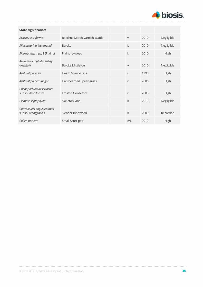
© Biosis 2012 – Leaders in Ecology and Heritage Consulting 38
State significance:
Acacia rostriformis Bacchus Marsh Varnish Wattle v 2010 Negligible
Allocasuarina luehmannii Buloke L 2010 Negligible
Alternanthera sp. 1 (Plains) Plains Joyweed k 2010 High
Amyema linophylla subsp.
orientale Buloke Mistletoe v 2010 Negligible
Austrostipa exilis Heath Spear-grass r 1995 High
Austrostipa hemipogon Half-bearded Spear-grass r 2006 High
Chenopodium desertorum
subsp. desertorum Frosted Goosefoot r 2008 High
Clematis leptophylla Skeleton Vine k 2010 Negligible
Convolvulus angustissimus
subsp. omnigracilis Slender Bindweed k 2009 Recorded
Cullen parvum Small Scurf-pea e/L 2010 High

© Biosis 2012 – Leaders in Ecology and Heritage Consulting 39
Appendix 3: Fauna Results
A3.1 Fauna species recorded from the study area
Australian status:
CR Critically Endangered (EPBC Act)
E Endangered (EPBC Act)
V Vulnerable (EPBC Act)
Victorian status: cr critically endangered (DSE 2007a)
e endangered (DSE 2007a)
v vulnerable (DSE 2007a)
cd conservation dependent (DSE 2007a)
nt near threatened (DSE 2007a)
dd data deficient (DSE 2007a)
L listed as threatened under FFG Act
* introduced species
Table A3.1. Vertebrate fauna recorded from the site during the present assessment (listed in
taxonomic order)
Status Scientific name Common name
Birds
Pelecanus conspicillatus Australian Pelican
Vanellus miles Masked Lapwing
Gallinago hardwickii Latham’s Snipe
Threskiornis spinicollis Straw-necked Ibis
Anas superciliosa Pacific Black Duck
Accipiter fasciatus Brown Goshawk
Elanus axillaris Black-shouldered Kite
Trichoglossus haematodus Rainbow Lorikeet
Hirundo neoxena Welcome Swallow
Rhipidura leucophrys Willie Wagtail
Grallina cyanoleuca Magpie-lark
Acanthiza chrysorrhoa Yellow-rumped Thornbill
Cincloramphus cruralis Brown Songlark
Cisticola exilis Golden-headed Cisticola
Malurus cyaneus Superb Fairy-wren
Zosterops lateralis Silvereye

© Biosis 2012 – Leaders in Ecology and Heritage Consulting 40
Status Scientific name Common name
Lichenostomus penicillatus White-plumed Honeyeater
Phylidonyris novaehollandiae New Holland Honeyeater
Anthochaera carunculata Red Wattlebird
Anthus novaeseelandiae Australasian Pipit
Gymnorhina tibicen Australian Magpie
Corvus mellori Little Raven
* Columba livia Rock Dove
* Streptopelia chinensis Spotted Turtle-Dove
* Turdus merula Common Blackbird
* Alauda arvensis European Skylark
* Passer domesticus House Sparrow
* Acridotheres tristis Common Myna
* Sturnus vulgaris Common Starling
Mammals
* Mus musculus House Mouse
* Oryctolagus cuniculus European Rabbit
* Lepus europeaus European Hare
* Vulpes vulpes Red Fox
Reptiles
Chelodina longicollis Common Long-necked Turtle
Tiliqua scincoides Common Blue-tongued Lizard
Frogs
Crinia signifera Common Froglet

© Biosis 2012 – Leaders in Ecology and Heritage Consulting 41
A3.2 Significant fauna species
Includes national and state significant species from the following sources:
• DSE Victorian Fauna Database 2009 Version
• DEWHA database (PMST accessed on 27.08.10)
• Birds Australia data search
• VAF data search
• MWF data search
• Current survey
Search area is 5 km radius. VAF and MWF search encompassed the Werribee River catchment.
Australian status: CR Critically Endangered (EPBC Act)
E Endangered (EPBC Act)
V Vulnerable (EPBC Act)
Victorian status: cr critically endangered (DSE 2007a)
e endangered (DSE 2007a)
v vulnerable (DSE 2007a)
cd conservation dependent (DSE 2007a)
nt near threatened (DSE 2007a)
dd data deficient (DSE 2007a)
L listed as threatened under FFG Act
Most recent record: # species predicted to occur by the PMST (not recorded on other databases unless dated)
## species predicted to occur based on natural distributional range and suitable habitat
despite lack of records in the databases searched
Year recorded on databases listed above
2010 recorded during fauna assessment
Likelihood of occurrence: – refer to Section 2.1.2
Table A3.2. Fauna of national or state significance recorded, or predicted to occur, within the
local area (listed in taxonomic order)
Scientific Name Common Name Aust.
status
Vic.
status
Most
recent
record
Likelihood of
occurrence
in study area
EPBC listed
Pachyptila turtur Fairy Prion VU vu 1999 Negligible
Thalassarche cauta Shy Albatross VU vu/L #/1956 Negligible
Rostratula australis Australian Painted Snipe VU cr/L #/1985 Low
Botaurus poiciloptilus Australasian Bittern EN en/L 1997 Medium
Neophema chrysogaster Orange-bellied Parrot CR cr/L 2004/# Medium
Lathamus discolor Swift Parrot EN en/L # Low
Anthochaera phrygia Regent Honeyeater EN cr/L # Negligible

© Biosis 2012 – Leaders in Ecology and Heritage Consulting 42
Scientific Name Common Name Aust.
status
Vic.
status
Most
recent
record
Likelihood of
occurrence
in study area
Diomedea exulans gibsoni Gibson's Albatross VU # Negligible
Macronectes giganteus Southern Giant-Petrel EN vu/L # Negligible
Diomedea bulleri Buller's Albatross VU L # Negligible
Macronectes halli Northern Giant-Petrel VU nt/L # Negligible
Dasyurus maculatus Spot-tailed Quoll EN en/L # Negligible
Isoodon obesulus obesulus Southern Brown Bandicoot EN nt # Negligible
Pteropus poliocephalus Grey-headed Flying-fox VU vu/L # Low
Pseudomys novaehollandiae New Holland Mouse VU vu/L # Negligible
Eubalaena australis Southern Right Whale EN cr/L # Negligible
Megaptera novaeangliae Humpback Whale VU vu/L 2001/# Negligible
Arctocephalus tropicalis Subantarctic Fur Seal VU 1989 Negligible
Caretta caretta Loggerhead Turtle EN # Negligible
Dermochelys coriacea Leathery Turtle VU cr/L # Negligible
Delma impar Striped Legless Lizard VU en/L 2005/# High
Tympanocryptis pinguicolla Grassland Earless Dragon EN cr/L # Low
Litoria raniformis Growling Grass Frog VU en/L 2006/# Low
Prototroctes maraena Australian Grayling VU vu/L # Not assessed
Galaxiella pusilla Dwarf Galaxias VU vu/L # Not assessed
Carcharadon carcharias Great White Shark VU vu/L # Negligible
Thalassarche salvini Salvin's Albatross VU # Negligible
Diomedea sanfordi Northern Royal Albatross EN vu # Negligible
Synemon plana Golden Sun Moth CR cr/L 2007 Recorded
State rare or threatened
Lewinia pectoralis Lewin's Rail vu/L 1986 Medium
Porzana pusilla Baillon's Crake vu/L 1997 Medium
Sula leucogaster Brown Booby en/L 1965 Negligible
Morus serrator Australasian Gannet nt/L 2003 Negligible
Gelochelidon nilotica Gull-billed Tern en/L 1982 Low
Hydroprogne caspia Caspian Tern nt/L 2002 Low
Sternula albifrons Little Tern vu/L 2003/# Negligible

© Biosis 2012 – Leaders in Ecology and Heritage Consulting 43
Scientific Name Common Name Aust.
status
Vic.
status
Most
recent
record
Likelihood of
occurrence
in study area
Sternula nereis Fairy Tern en/L 1996 Negligible
Charadrius mongolus Lesser Sand Plover vu 1992 Negligible
Numenius phaeopus Whimbrel vu #/1986 Low
Limosa limosa Black-tailed Godwit vu #/1986 Low
Tringa glareola Wood Sandpiper vu 1994/# Low
Heteroscelus brevipes Grey-tailed Tattler cr/L 2006/# Low
Actitis hypoleucos Common Sandpiper vu 2000 Low
Xenus cinereus Terek Sandpiper en/L 1997 Low
Calidris tenuirostris Great Knot en/L #/1982 Low
Platalea regia Royal Spoonbill vu 2006 Medium
Egretta garzetta Little Egret en/L 2006 Medium
Ardea intermedia Intermediate Egret cr/L 1999 Low
Ardea modesta Eastern Great Egret vu/L 2006/# Medium
Ixobrychus minutus Little Bittern en/L 1980 Medium
Anseranas semipalmata Magpie Goose nt/L 2000 Low
Anas rhynchotis Australasian Shoveler vu 2003 Low
Stictonetta naevosa Freckled Duck en/L 1985 Low
Aythya australis Hardhead vu 2003 Low
Oxyura australis Blue-billed Duck en/L 2002 Low
Biziura lobata Musk Duck vu 2003 Low
Haliaeetus leucogaster White-bellied Sea-Eagle vu/L 1993/# Low
Falco subniger Black Falcon vu 1990 Medium
Saccolaimus flaviventris Yellow-bellied Sheathtail Bat L 1993 Low
Arctocephalus forsteri New Zealand Fur Seal vu # Negligible
Pseudophryne bibronii Brown Toadlet en/L 1871 Low
Bidyanus bidyanus Silver Perch cr/L 1992 Not assessed
Hesperilla flavescens flavescens Altona Skipper vu/L 1988 High
Other conservation categories
Coturnix ypsilophora Brown Quail nt 2003 High
Phalacrocorax fuscescens Black-faced Cormorant nt 2006 Low

© Biosis 2012 – Leaders in Ecology and Heritage Consulting 44
Scientific Name Common Name Aust.
status
Vic.
status
Most
recent
record
Likelihood of
occurrence
in study area
Phalacrocorax varius Pied Cormorant nt 2006 Low
Chlidonias hybridus Whiskered Tern nt 2003 Low
Thalaseus bergii Crested Tern nt 2006 Negligible
Larus pacificus pacificus Pacific Gull nt 2006 Low
Haematopus fuliginosus Sooty Oystercatcher nt 2001 Negligible
Pluvialis squatarola Grey Plover nt 1992 Low
Pluvialis fulva Pacific Golden Plover nt 2006/# Low
Numenius madagascariensis Eastern Curlew nt 1997/# Low
Calidris canutus Red Knot nt 2000/# Low
Calidris alba Sanderling nt 2000 Negligible
Gallinago hardwickii Latham's Snipe nt 2011/# Recorded
Plegadis falcinellus Glossy Ibis nt 1996 Medium
Nycticorax caledonicus Nankeen Night Heron nt 1996 High
Cereopsis novaehollandiae Cape Barren Goose nt 1999 Low
Circus assimilis Spotted Harrier nt 1985 Low
Chrysococcyx osculans Black-eared Cuckoo nt 1987 Negligible
Calidris melanotus X ferruginea Cox's Sandpiper nt 1982 Low
Balaenoptera edeni Bryde's Whale dd # Negligible
Calidris melanotos Pectoral Sandpiper nt #/1987 Low
Sminthopsis crassicaudata Fat-tailed Dunnart nt 2005 High

© Biosis 2012 – Leaders in Ecology and Heritage Consulting 45
A3.3 Migratory species
Includes records from the following sources:
• DSE Victorian Fauna Database 2007 Version
• DEWHA database (PMST accessed on 27.08.10)
• Birds Australia data search
• Current survey
Search area is 5 km radius.
Most recent record: # species predicted to occur by the PMST (not recorded on other databases unless dated)
Year recorded on databases listed above
2010/2011 recorded during current survey
Table A3.3. Migratory species recorded, or predicted to occur, within 5 kilometres of the site
Scientific Name Common Name Most recent record
Ardenna tenuirostris Short-tailed Shearwater 2000
Thalassarche cauta Shy Albatross #/1956
Hydroprogne caspia Caspian Tern 2002
Sternula albifrons Little Tern 2003/#
Stercorarius parasiticus Arctic Jaeger 2000
Arenaria interpres Ruddy Turnstone 2006/#
Pluvialis squatarola Grey Plover 1992
Pluvialis fulva Pacific Golden Plover 2006/#
Charadrius mongolus Lesser Sand Plover 1992
Charadrius bicinctus Double-banded Plover 2006/#
Numenius madagascariensis Eastern Curlew 1997/#
Numenius phaeopus Whimbrel #/1986
Numenius minutus Little Curlew #
Limosa limosa Black-tailed Godwit #/1986
Limosa lapponica Bar-tailed Godwit 1997/#
Tringa glareola Wood Sandpiper 1994/#
Heteroscelus brevipes Grey-tailed Tattler 2006/#
Actitis hypoleucos Common Sandpiper 2000
Tringa nebularia Common Greenshank 2006
Tringa stagnatilis Marsh Sandpiper 2006/#
Xenus cinereus Terek Sandpiper 1997

© Biosis 2012 – Leaders in Ecology and Heritage Consulting 46
Calidris ferruginea Curlew Sandpiper 2006/#
Calidris ruficollis Red-necked Stint 2006/#
Calidris acuminata Sharp-tailed Sandpiper 2006/#
Calidris canutus Red Knot 2000/#
Calidris tenuirostris Great Knot #/1982
Calidris alba Sanderling 2000
Limicola falcinellus Broad-billed Sandpiper #/1986
Gallinago hardwickii Latham's Snipe 2011/#
Rostratula australis Australian Painted Snipe #/1985
Plegadis falcinellus Glossy Ibis 1996
Ardea modesta Eastern Great Egret 2006/#
Haliaeetus leucogaster White-bellied Sea-Eagle 1993/#
Neophema chrysogaster Orange-bellied Parrot 2004/#
Merops ornatus Rainbow Bee-eater #
Hirundapus caudacutus White-throated Needletail 2005/#
Apus pacificus Fork-tailed Swift #/1977
Rhipidura rufifrons Rufous Fantail #
Myiagra cyanoleuca Satin Flycatcher #
Acrocephalus stentoreus Clamorous Reed Warbler 2001
Anthochaera phrygia Regent Honeyeater #
Diomedea exulans gibsoni Gibson's Albatross #
Tryngites subruficollis Buff-breasted Sandpiper 1962
Macronectes giganteus Southern Giant-Petrel #
Diomedea bulleri Buller's Albatross #
Phalaropus lobatus Red-necked Phalarope 1992
Philomachus pugnax Ruff #/1988
Macronectes halli Northern Giant-Petrel #
Sterna hirundo Common Tern 2001
Calidris subminuta Long-toed Stint #/1986
Ardea ibis Cattle Egret 2005/#
Calidris melanotos Pectoral Sandpiper #/1987
Eubalaena australis Southern Right Whale #

© Biosis 2012 – Leaders in Ecology and Heritage Consulting 47
Caperea marginata Pygmy Right Whale #
Balaenoptera edeni Bryde's Whale #
Megaptera novaeangliae Humpback Whale 2001/#
Lagenorhynchus obscurus Dusky Dolphin #
Tursiops aduncus Indian Ocean Bottlenose Dolphin #
Caretta caretta Loggerhead Turtle #
Dermochelys coriacea Leathery Turtle #
Carcharadon carcharias Great White Shark #
Diomedea sanfordi Northern Royal Albatross #
Thalassarche salvini Salvin's Albatross #
Gallinago megala Swinhoe's Snipe #
Gallinago stenura Pin-tailed Snipe #
Thalassarche impavida Campbell Albatross #
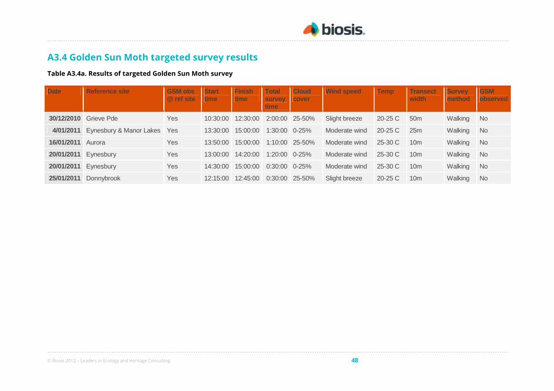
© Biosis 2012 – Leaders in Ecology and Heritage Consulting 48
A3.4 Golden Sun Moth targeted survey results
Table A3.4a. Results of targeted Golden Sun Moth survey
Date Reference site GSM obs @ ref site
Start time
Finish time
Total survey time
Cloud cover
Wind speed Temp Transect width
Survey method
GSM observed
30/12/2010 Grieve Pde Yes 10:30:00 12:30:00 2:00:00 25-50% Slight breeze 20-25 C 50m Walking No
4/01/2011 Eynesbury & Manor Lakes Yes 13:30:00 15:00:00 1:30:00 0-25% Moderate wind 20-25 C 25m Walking No
16/01/2011 Aurora Yes 13:50:00 15:00:00 1:10:00 25-50% Moderate wind 25-30 C 10m Walking No
20/01/2011 Eynesbury Yes 13:00:00 14:20:00 1:20:00 0-25% Moderate wind 25-30 C 10m Walking No
20/01/2011 Eynesbury Yes 14:30:00 15:00:00 0:30:00 0-25% Moderate wind 25-30 C 10m Walking No
25/01/2011 Donnybrook Yes 12:15:00 12:45:00 0:30:00 25-50% Slight breeze 20-25 C 10m Walking No
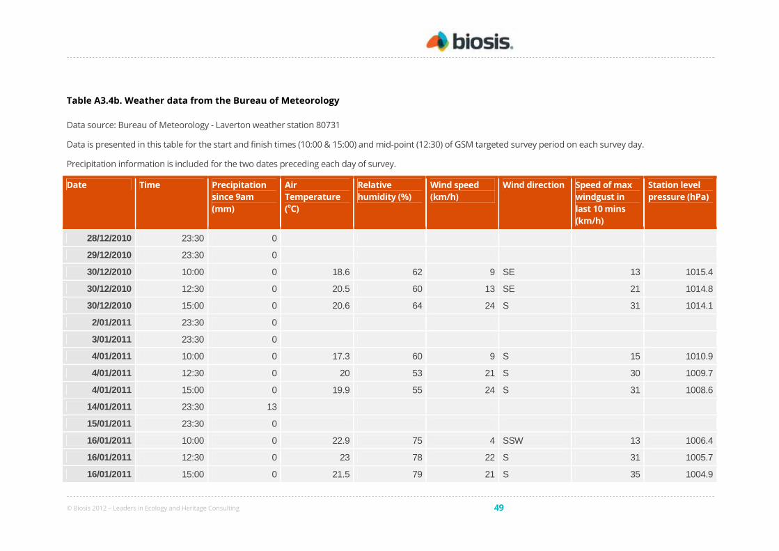
© Biosis 2012 – Leaders in Ecology and Heritage Consulting 49
Table A3.4b. Weather data from the Bureau of Meteorology
Data source: Bureau of Meteorology - Laverton weather station 80731
Data is presented in this table for the start and finish times (10:00 & 15:00) and mid-point (12:30) of GSM targeted survey period on each survey day.
Precipitation information is included for the two dates preceding each day of survey.
Date Time Precipitation
since 9am
(mm)
Air
Temperature
(oC)
Relative
humidity (%)
Wind speed
(km/h)
Wind direction Speed of max
windgust in
last 10 mins
(km/h)
Station level
pressure (hPa)
28/12/2010 23:30 0
29/12/2010 23:30 0
30/12/2010 10:00 0 18.6 62 9 SE 13 1015.4
30/12/2010 12:30 0 20.5 60 13 SE 21 1014.8
30/12/2010 15:00 0 20.6 64 24 S 31 1014.1
2/01/2011 23:30 0
3/01/2011 23:30 0
4/01/2011 10:00 0 17.3 60 9 S 15 1010.9
4/01/2011 12:30 0 20 53 21 S 30 1009.7
4/01/2011 15:00 0 19.9 55 24 S 31 1008.6
14/01/2011 23:30 13
15/01/2011 23:30 0
16/01/2011 10:00 0 22.9 75 4 SSW 13 1006.4
16/01/2011 12:30 0 23 78 22 S 31 1005.7
16/01/2011 15:00 0 21.5 79 21 S 35 1004.9

© Biosis 2012 – Leaders in Ecology and Heritage Consulting 50
Date Time Precipitation
since 9am
(mm)
Air
Temperature
(oC)
Relative
humidity (%)
Wind speed
(km/h)
Wind direction Speed of max
windgust in
last 10 mins
(km/h)
Station level
pressure (hPa)
18/01/2011 23:30 0
19/01/2011 23:30 0
20/01/2011 10:00 0 20.3 66 5 NW 11 1009.7
20/01/2011 12:30 0 22.8 63 18 S 24 1008.1
20/01/2011 15:00 0 25.3 55 15 SSE 18 1007.1
23/01/2011 23:30 0
24/01/2011 23:30 0.2
25/01/2011 10:00 0 19.5 60 9 E 15 1005.6
25/01/2011 12:30 0 23.7 47 8 E 15 1004.7
25/01/2011 15:00 0 24 52 15 SSE 24 1004.4
© Biosis 2012 – Leaders in Ecology and Heritage Consulting 51
Appendix 4: Legislation, Government Policy & Strategies
Following is an outline of the Government legislation and policies directly relevant to this assessment.
Commonwealth
Environment Protection and Biodiversity Conservation Act 1999
The Environment Protection and Biodiversity Conservation Act 1999 (EPBC Act) applies to developments and associated
activities that have the potential to significantly impact on matters protected under the Act.
Under the Act, unless exempt, actions require approval from the Australian Government Minister for Environment,
Heritage and the Arts if they are likely to significantly impact on a ‘matter of national environmental significance’
(NES). Matters of NES are:
• World Heritage properties;
• National Heritage places;
• Listed threatened species and ecological communities;
• Listed migratory species;
• Wetlands of international importance (Ramsar sites);
• The Commonwealth marine environment; and
• Nuclear actions (including uranium mining).
The EPBC Act also applies to the environment in general if actions are taken on Commonwealth land, or if actions
that are taken outside Commonwealth land will impact on the environment of Commonwealth land.
Any person proposing to take an action that may, or will, have a significant impact on a matter of NES must refer
the action to the Commonwealth Government Minister for Environment, Heritage and the Arts for determination as
to whether or not the action is a ‘Controlled Action.’ ‘Significant impacts’ are defined in EPBC Act Policy Statement 1.1
Significant Impact Guidelines: Matters of National Environmental Significance (DEH 2006).
State
Flora and Fauna Guarantee Act 1988
The primary legislation dealing with biodiversity conservation and sustainable use of native flora and fauna is the
Flora and Fauna Guarantee Act 1988 (FFG Act).
The FFG Act provides for the listing of taxa (genera, species, subspecies, varieties) and communities of flora and
fauna which are threatened, and of potentially threatened processes. The Act includes a list of Protected Flora, to
which flora taxa and species of listed communities are added. The Act contains powers over the taking, trading and
keeping of listed fish.
The protected flora list has three sources:
• plant taxa (species, subspecies or varieties) listed as threatened under the Flora and Fauna Guarantee Act
1988;
• plant taxa belonging to communities listed as threatened under the Flora and Fauna Guarantee Act 1988;
• plant taxa which are not threatened but require protection for other reasons.
© Biosis 2012 – Leaders in Ecology and Heritage Consulting 52
Critical Habitat on private land can be declared under the Act for either a species or an ecological community. In
areas of Critical Habitat, the Minister for Sustainability and Environment can impose an Interim Conservation Order
(ICO). However, there have been no areas of Critical Habitat identified in Victoria. and consequently there are no
ICOs.
A permit is required from DSE to 'take' (kill, injure, disturb or collect) protected flora species, including members of
listed communities, from public land, or from areas of defined Critical Habitat on private land.
A permit is required from DSE to 'take' listed fish species.
A permit is not required to ‘take’ listed fauna or members of a listed fauna community under the FFG Act. Controls
in relation to protection of fauna are provided under the Wildlife Act 1975 and the Wildlife Regulations 2002 (see
below).
Planning and Environment Act 1987
The Planning and Environment Act 1987 controls the planning and development of land in Victoria. The Act provides
for the development of a planning scheme for all municipalities. Planning schemes follow a standard format and
contain state and local components. The Victoria Planning Provisions (VPP) comprise the standard State sections -
the State Planning Policy Framework (SPPF Clauses 10 to 19), Particular Provisions (Clauses 51 to 56) and General
Provisions (Clauses 60 to 67).
The planning authority provides the local planning policy content, and applies the relevant zones and overlays to
particular areas for a particular planning scheme.
Municipal planning schemes include controls over the removal of native vegetation, including permit requirements,
as follows:
Clause 15 contains higher order objectives, strategies and implementation measures for the conservation of the
environment, including waterways, flora and fauna. Clause 15.09 states that “Planning and responsible authorities
must have regard to Victoria’s Native Vegetation Management – A Framework for Action (Department of Natural Resources
and Environment 2002).
Clause 52.17 requires a planning permit to remove, destroy or lop native vegetation including dead native
vegetation. This does not apply (to the removal of native vegetation to the minimum extent necessary) if any item
in the table of exemptions (Clause 52.17-6) is applicable, or to specific native vegetation or a specific area as
specified in a schedule to Clause 52.17, or if clearance is in accordance with a native vegetation precinct plan.
Clause 65.02 requires consideration of native vegetation retention in subdivision applications.
Additional permit requirements may apply under overlays introduced into an individual planning scheme, such as a
Vegetation Protection Overlay, or Environmental Significance Overlay.
DSE is a mandatory referral authority in some circumstances involving permit applications for native vegetation
removal. Under Clause 66.02, the removal of more than 0.5 hectares of endangered, vulnerable or rare vegetation
types or more than 1.0 hectare of a depleted or least concern vegetation type must be referred to the Department.
DSE is also a referral authority if the removal of more than 5 trees of greater than 40 cm DBH OR more than 15
trees of less than 40 cm DBH is proposed.

© Biosis 2012 – Leaders in Ecology and Heritage Consulting 53
Native Vegetation Management Framework
The Native Vegetation Management Framework (NRE 2002) is State Government policy for the protection,
enhancement and revegetation of native vegetation in Victoria. Native vegetation provisions were introduced to all
planning schemes in 1989 and the Framework was incorporated into the Victoria Planning Provisions in 2003. The
primary goal of the Framework is:
a reversal, across the whole landscape, of the long-term decline in the extent and quality of
native vegetation, leading to a Net Gain (NRE 2002).
Where an application is made to remove native vegetation, a proponent for a development must explain the steps
that have been taken to:
• Avoid the removal of native vegetation, where possible
• Minimise the removal of native vegetation.
• Appropriately offset the loss of native vegetation, if required.
A proponent for a development must demonstrate that the option to avoid and minimise vegetation clearance has
been fully explored before considering offsets
An offset may be achieved by improvements in the quality or extent of native vegetation in a selected ‘offset area’,
either within a project area or off-site. An area that is revegetated and protected or set aside for natural
regeneration may provide some, or all, of the required offset. The conservation significance of vegetation to be
removed is also taken into account when offsets are determined.
Regional Native Vegetation Plans
Native Vegetation Plans have been prepared to develop a strategic and co-ordinated approach to the management
of native vegetation within a given Catchment Management Authority region. The plans are designed to
complement the Native Vegetation Management Framework and contains specific information and objectives
relating to the region.
The Native Vegetation Plans outline strategic directions including:
• Retaining the quantity of native vegetation by minimising clearing;
• Protecting native vegetation with reservation and management agreements;
• Maintaining and improve the quality of native vegetation; and
• Increasing the quantity of native vegetation.
Responses and offset requirements for clearing native vegetation are outlined. Tree offsets that are not covered by
the Framework replacement ratios are calculated using the Regional Native Vegetation Plan where available.
Wildlife Act 1975 and associated Regulations
The Wildlife Act 1975 is the primary legislation in Victoria providing for protection and management of wildlife. For
the purposes of the Act, wildlife means indigenous vertebrate species (except those declared as pest animals),
invertebrate species listed under the FFG Act, and some introduced game species.
The Wildlife Regulations 2002 of the Act prescribe the penalties for certain activities relevant to wildlife. These
include penalties for persons who wilfully damage, disturb or destroy any wildlife habitat without appropriate
authorisation (Section 9 of the Wildlife Regulations 2002). Authorisation for habitat removal may be obtained under
the Wildlife Act; through a licence granted under the Forests Act 1958; or under any other Act.
Authorisation to destroy or possess wildlife may be required (Sections 41– 47) if wildlife needs to be moved or
destroyed during development.

© Biosis 2012 – Leaders in Ecology and Heritage Consulting 54
Appendix 5: EVC Benchmarks
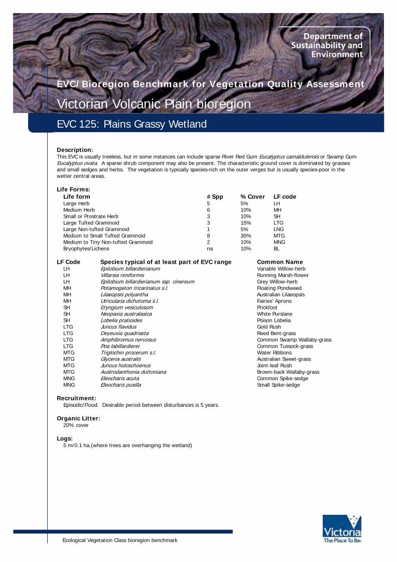
Ecological Vegetation Class bioregion benchmark
EVC/Bioregion Benchmark for Vegetation Quality Assessment
Victorian Volcanic Plain bioregionEVC 125: Plains Grassy Wetland
Description:This EVC is usually treeless, but in some instances can include sparse River Red Gum Eucalyptus camaldulensis or Swamp GumEucalyptus ovata. A sparse shrub component may also be present. The characteristic ground cover is dominated by grassesand small sedges and herbs. The vegetation is typically species-rich on the outer verges but is usually species-poor in thewetter central areas.
Life Forms:Life form #Spp %Cover LF codeLarge Herb 5 5% LHMedium Herb 6 10% MHSmall or Prostrate Herb 3 10% SHLarge Tufted Graminoid 3 15% LTGLarge Non-tufted Graminoid 1 5% LNGMedium to Small Tufted Graminoid 8 30% MTGMedium to Tiny Non-tufted Graminoid 2 10% MNGBryophytes/Lichens na 10% BL
LF Code Species typical of at least part of EVC range Common NameLH Epilobium billardierianum Variable Willow-herbLH Villarsia reniformis Running Marsh-flowerLH Epilobium billardierianum ssp. cinereum Grey Willow-herbMH Potamogeton tricarinatus s.l. Floating PondweedMH Lilaeopsis polyantha Australian LilaeopsisMH Utricularia dichotoma s.l. Fairies' ApronsSH Eryngium vesiculosum PrickfootSH Neopaxia australasica White PurslaneSH Lobelia pratioides Poison LobeliaLTG Juncus flavidus Gold RushLTG Deyeuxia quadriseta Reed Bent-grassLTG Amphibromus nervosus Common Swamp Wallaby-grassLTG Poa labillardierei Common Tussock-grassMTG Triglochin procerum s.l. Water RibbonsMTG Glyceria australis Australian Sweet-grassMTG Juncus holoschoenus Joint-leaf RushMTG Austrodanthonia duttoniana Brown-back Wallaby-grassMNG Eleocharis acuta Common Spike-sedgeMNG Eleocharis pusilla Small Spike-sedge
Recruitment: Episodic/Flood. Desirable period between disturbances is 5 years.
Organic Litter:20% cover
Logs:5 m/0.1 ha.(where trees are overhanging the wetland)

Published by the Victorian Government Department of Sustainability and Environment May 2004
© The State of Victoria Department of Sustainability and Environment 2004
This publication is copyright. Reproduction and the making available of this material for personal, in-house or non-commercial purposes is authorised, on condition that:• the copyright owner is acknowledged;• no official connection is claimed;• the material is made available without charge or at cost; and• the material is not subject to inaccurate, misleading or derogatory treatment.
Requests for permission to reproduce or communicate this material in any way not permitted by this licence (or by the fair dealing provisions of the Copyright Act 1968) should bedirected to the Nominated Officer, Copyright, 8 Nicholson Street, East Melbourne, Victoria, 3002.
For more information contact: Customer Service Centre, 136 186
This publication may be of assistance to you but the State of Victoria and its employees do not guarantee that the publication is without flaw of any kind or is wholly appropriatefor your particular purposes and therefore disclaims all liability for any error, loss or other consequence which may arise from you relying on any information in this publication.
www.dse.vic.gov.au
EVC 125: Plains Grassy Wetland - Victorian Volcanic Plain bioregion
Weediness:LF Code Typical Weed Species Common Name Invasive ImpactLH Cirsium vulgare Spear Thistle high highMH Leontodon taraxacoides ssp. taraxacoides Hairy Hawkbit high lowMH Hypochoeris radicata Cat's Ear high lowLTG Phalaris aquatica Toowoomba Canary-grass high highLNG Holcus lanatus Yorkshire Fog high highMTG Briza minor Lesser Quaking-grass high lowMTG Romulea rosea Onion Grass high lowTTG Cyperus tenellus Tiny Flat-sedge high low

Ecological Vegetation Class bioregion benchmark
EVC/Bioregion Benchmark for Vegetation Quality Assessment
Victorian Volcanic Plain bioregionEVC 132_61: Heavier-soils Plains Grassland
Description:Treeless vegetation mostly less than 1 m tall dominated by largely graminoid and herb life forms. Occupies fertile crackingbasalt soils prone to seasonal waterlogging in areas receiving at least 500 mm annual rainfall.
Life Forms:Life form #Spp %Cover LF codeLarge Herb 2 5% LH Medium Herb 12 20% MH Small or Prostrate Herb 4 5% SH Large Tufted Graminoid 1 5% LTGMedium to Small Tufted Graminoid 13 40% MTGMedium to Tiny Non-tufted Graminoid 4 5% MNGBryophytes/Lichens and Soil Crust* na 20% BL
* Note: treat as one life form in this EVC
LF Code Species typical of at least part of EVC range Common NameSS Pimelea humilis Common Rice-flowerLH Rumex dumosus Wiry DockMH Calocephalus citreus Lemon Beauty-headsMH Acaena echinata Sheep's BurrMH Leptorhynchos squamatus Scaly ButtonsMH Eryngium ovinum Blue DevilSH Solenogyne dominii Smooth SolenogyneSH Lobelia pratioides Poison LobeliaLTG Austrostipa bigeniculata Kneed Spear-grassLTG Dichelachne crinita Long-hair Plume-grassMTG Themeda triandra Kangaroo GrassMTG Austrodanthonia caespitosa Common Wallaby-grassMTG Elymus scaber var. scaber Common Wheat-grassMTG Schoenus apogon Common Bog-sedgeMNG Microlaena stipoides var. stipoides Weeping GrassMNG Thelymitra pauciflora s.l. Slender Sun-orchidMNG Microtis unifolia Common Onion-orchidSC Convolvulus erubescens Pink Bindweed
Recruitment:Episodic/Fire or Grazing. Desirable period between disturbances is 5 years.
Organic Litter:10% cover

Published by the Victorian Government Department of Sustainability and Environment December 2004
© The State of Victoria Department of Sustainability and Environment 2004
This publication is copyright. Reproduction and the making available of this material for personal, in-house or non-commercial purposes is authorised, on condition that:• the copyright owner is acknowledged;• no official connection is claimed;• the material is made available without charge or at cost; and• the material is not subject to inaccurate, misleading or derogatory treatment.
Requests for permission to reproduce or communicate this material in any way not permitted by this licence (or by the fair dealing provisions of the Copyright Act 1968) should bedirected to the Nominated Officer, Copyright, 8 Nicholson Street, East Melbourne, Victoria, 3002.
For more information contact: Customer Service Centre, 136 186
This publication may be of assistance to you but the State of Victoria and its employees do not guarantee that the publication is without flaw of any kind or is wholly appropriatefor your particular purposes and therefore disclaims all liability for any error, loss or other consequence which may arise from you relying on any information in this publication.
www.dse.vic.gov.au
EVC 132_61: Heavier-soils Plains Grassland -Victorian Volcanic Plain bioregion
Weediness:LF Code Typical Weed Species Common Name Invasive ImpactLH Plantago lanceolata Ribwort high lowLH Cirsium vulgare Spear Thistle high highLH Sonchus oleraceus Common Sow-thistle high lowMH Hypochoeris radicata Cat's Ear high lowMH Leontodon taraxacoides ssp. taraxacoides Hairy Hawkbit high lowMH Trifolium subterraneum Subterranean Clover high lowMH Plantago coronopus Buck's-horn Plantain high lowMH Trifolium striatum Knotted Clover high lowMH Trifolium dubium Suckling Clover high lowLTG Phalaris aquatica Toowoomba Canary-grass high highLNG Holcus lanatus Yorkshire Fog high highMTG Romulea rosea Onion Grass high lowMTG Vulpia bromoides Squirrel-tail Fescue high lowMTG Briza minor Lesser Quaking-grass high lowMTG Bromus hordeaceus ssp. hordeaceus Soft Brome high lowMTG Briza maxima Large Quaking-grass high lowMTG Lolium rigidum Wimmera Rye-grass high lowMTG Lolium perenne Perennial Rye-grass high lowMTG Nassella neesiana Chilean Needle-grass high highMNG Cynosurus echinatus Rough Dog's-tail high lowMNG Juncus capitatus Capitate Rush high low

Ecological Vegetation Class bioregion benchmark
EVC/Bioregion Benchmark for Vegetation Quality Assessment
Victorian Volcanic Plain bioregionEVC 132_63: Low-rainfall Plains Grassland
Description:Treeless vegetation mostly < 1 m tall dominated by largely graminoid and herb life forms. Occupies cracking basalt soils proneto seasonal waterlogging in areas receiving < 500 mm annual rainfall.
Life forms:Life form #Spp %Cover LF codeSmall Shrub* 1 5% SS Prostrate Shrub 1 5% PSLarge Herb* 2 5% LH Medium Herb 8 20% MH Small or Prostrate Herb* 3 10% SH Large Tufted Graminoid 1 5% LTGMedium to Small Tufted Graminoid 10 30% MTGMedium to Tiny Non-tufted Graminoid* 2 5% MNGBryophytes/Lichens and Soil Crust** na 20% BL
* Largely seasonal life form** Note: treat as one life form in this EVC
LF Code Species typical of at least part of EVC range Common NameSS Pimelea curviflora s.s. Curved Rice-flowerPS Atriplex semibaccata Berry SaltbushLH Ptilotus macrocephalus Feather-headsMH Acaena echinata Sheep's BurrMH Plantago gaudichaudii Narrow PlantainMH Maireana enchylaenoides Wingless BluebushMH Calocephalus citreus Lemon Beauty-headsSH Solenogyne dominii Smooth SolenogyneSH Oxalis perennans Grassland Wood-sorrelSH Chamaesyce drummondii Flat SpurgeSH Goodenia pinnatifida Cut-leaf GoodeniaLTG Austrostipa bigeniculata Kneed Spear-grassMTG Austrostipa scabra Rough Spear-grassMTG Austrostipa nodosa Knotty Spear-grassMTG Whalleya proluta Rigid PanicMTG Austrodanthonia duttoniana Brown-back Wallaby-grassTTG Centrolepis strigosa ssp. strigosa Hairy CentrolepisTTG Centrolepis aristata Pointed CentrolepisSC Convolvulus erubescens spp. agg. Pink Bindweed
Recruitment:Episodic/Fire or Grazing. Desirable period between disturbances is 5 years.
Organic Litter:10% cover
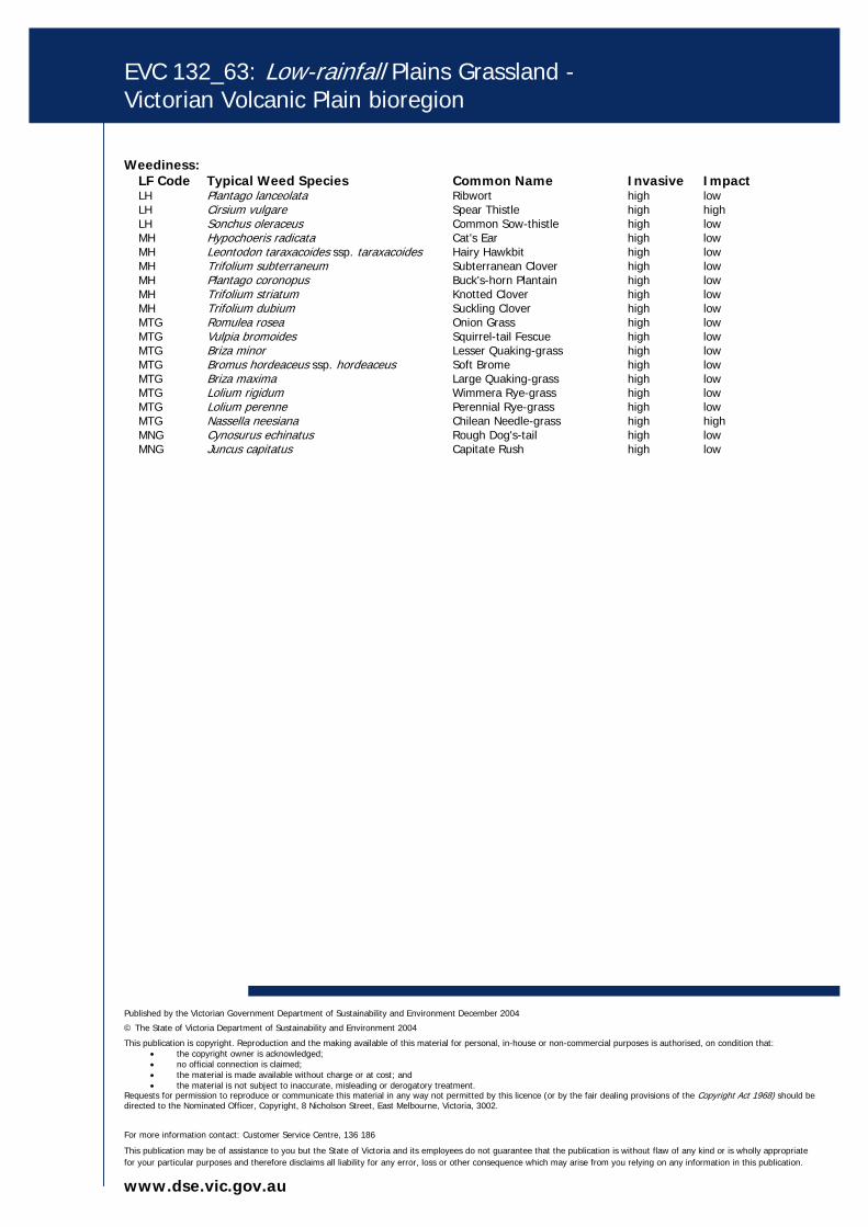
Published by the Victorian Government Department of Sustainability and Environment December 2004
© The State of Victoria Department of Sustainability and Environment 2004
This publication is copyright. Reproduction and the making available of this material for personal, in-house or non-commercial purposes is authorised, on condition that:• the copyright owner is acknowledged;• no official connection is claimed;• the material is made available without charge or at cost; and• the material is not subject to inaccurate, misleading or derogatory treatment.
Requests for permission to reproduce or communicate this material in any way not permitted by this licence (or by the fair dealing provisions of the Copyright Act 1968) should bedirected to the Nominated Officer, Copyright, 8 Nicholson Street, East Melbourne, Victoria, 3002.
For more information contact: Customer Service Centre, 136 186
This publication may be of assistance to you but the State of Victoria and its employees do not guarantee that the publication is without flaw of any kind or is wholly appropriatefor your particular purposes and therefore disclaims all liability for any error, loss or other consequence which may arise from you relying on any information in this publication.
www.dse.vic.gov.au
EVC 132_63: Low-rainfall Plains Grassland -Victorian Volcanic Plain bioregion
Weediness:LF Code Typical Weed Species Common Name Invasive ImpactLH Plantago lanceolata Ribwort high lowLH Cirsium vulgare Spear Thistle high highLH Sonchus oleraceus Common Sow-thistle high lowMH Hypochoeris radicata Cat's Ear high lowMH Leontodon taraxacoides ssp. taraxacoides Hairy Hawkbit high lowMH Trifolium subterraneum Subterranean Clover high lowMH Plantago coronopus Buck's-horn Plantain high lowMH Trifolium striatum Knotted Clover high lowMH Trifolium dubium Suckling Clover high lowMTG Romulea rosea Onion Grass high lowMTG Vulpia bromoides Squirrel-tail Fescue high lowMTG Briza minor Lesser Quaking-grass high lowMTG Bromus hordeaceus ssp. hordeaceus Soft Brome high lowMTG Briza maxima Large Quaking-grass high lowMTG Lolium rigidum Wimmera Rye-grass high lowMTG Lolium perenne Perennial Rye-grass high lowMTG Nassella neesiana Chilean Needle-grass high highMNG Cynosurus echinatus Rough Dog's-tail high lowMNG Juncus capitatus Capitate Rush high low
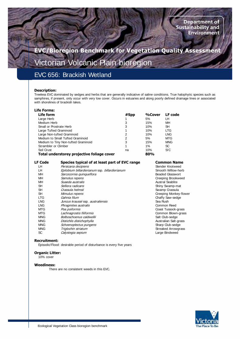
Ecological Vegetation Class bioregion benchmark
EVC/Bioregion Benchmark for Vegetation Quality Assessment
Victorian Volcanic Plain bioregionEVC 656: Brackish Wetland
Description:Treeless EVC dominated by sedges and herbs that are generally indicative of saline conditions. True halophytic species such assamphires, if present, only occur with very low cover. Occurs in estuaries and along poorly defined drainage lines or associatedwith shorelines of brackish lakes.
Life Forms:Life form #Spp %Cover LF codeLarge Herb 1 5% LHMedium Herb 3 15% MHSmall or Prostrate Herb 3 10% SHLarge Tufted Graminoid 1 10% LTGLarge Non-tufted Graminoid 2 10% LNGMedium to Small Tufted Graminoid 2 5% MTGMedium to Tiny Non-tufted Graminoid 3 15% MNGScrambler or Climber 1 1% SCSoil Crust na 10% S/CTotal understorey projective foliage cover 80%
LF Code Species typical of at least part of EVC range Common NameLH Persicaria decipiens Slender KnotweedLH Epilobium billardierianum ssp. billardierianum Smooth Willow-herbMH Sarcocornia quinqueflora Beaded GlasswortMH Samolus repens Creeping BrookweedMH Suaeda australis Austral SeabliteSH Selliera radicans Shiny Swamp-matSH Crassula helmsii Swamp CrassulaSH Mimulus repens Creeping Monkey-flowerLTG Gahnia filum Chaffy Saw-sedgeLNG Juncus kraussii ssp. australiensis Sea RushLNG Phragmites australis Common ReedMTG Poa poiformis Coast Tussock-grassMTG Lachnagrostis filiformis Common Blown-grassMNG Bolboschoenus caldwellii Salt Club-sedgeMNG Distichlis distichophylla Australian Salt-grassMNG Schoenoplectus pungens Sharp Club-sedgeMNG Triglochin striatum Streaked ArrowgrassSC Calystegia sepium Large Bindweed
Recruitment:Episodic/Flood: desirable period of disturbance is every five years
Organic Litter:10% cover
Weediness:There are no consistent weeds in this EVC.

© Biosis 2012 – Leaders in Ecology and Heritage Consulting 61
Appendix 6: DSE Net Gain
Calculator Output
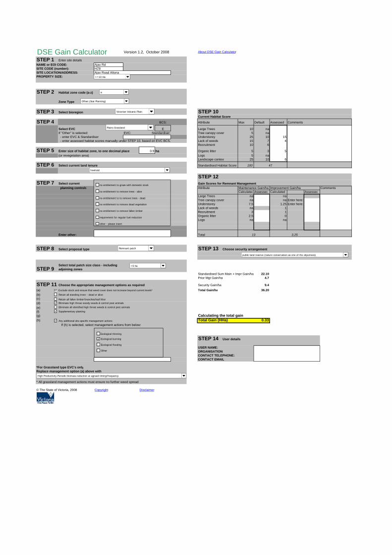
DSE Gain Calculator Version 1.2, October 2008 About DSE Gain Calculator
STEP 1 Enter site detailsNAME or EOI CODE: Ajax RdSITE CODE (number): HZ8SITE LOCATION/ADDRESS:PROPERTY SIZE:
STEP 2 Habitat zone code (a-z)
Zone Type
STEP 3 Select bioregion STEP 10Current Habitat Score
STEP 4 BCS: Attribute Max Default Assessed Comments
Select EVC E Large Trees 10 naIf "Other" is selected: EVC: Standardiser: Tree canopy cover 5 na - enter EVC & Standardiser Understorey 25 10 15 - enter assessed habitat scores manually under STEP 10, based on EVC BCS. Lack of weeds 15 7 4
Recruitment 10 6
STEP 5 Enter size of habitat zone, to one decimal place 0.9 ha Organic litter 5 3 5(or revegetation area) Logs 5 na
Landscape context 25 10 6
STEP 6 Select current land tenure Standardised Habitat Score 100
STEP 12STEP 7 Select current Gain Scores for Remnant Management
planning controls Attribute Maintenance Gain/ha Improvement Gain/ha CommentsCalculated Assessed Calculated Assessed
Large Trees na naTree canopy cover na na Enter here:Understorey 7.5 1.25 Enter here:Lack of weeds na 1Recruitment 3 1Organic litter 2.5 0Logs na na
Enter other: Total
STEP 8 Select proposal type STEP 13 Choose security arrangement
STEP 9Standardised Sum Main + Impr Gain/ha 22.10Prior Mgt Gain/ha 4.7
STEP 11 Choose the appropriate management options as required Security Gain/ha 9.4(a) Exclude stock and ensure that weed cover does not increase beyond current levels* Total Gain/ha 36.20(b)(c)(d)(e)(f)(g) Calculating the total gain(h) Total Gain (HHa) 0.33
If (h) is selected, select management actions from below:
STEP 14 User details
USER NAME:ORGANISATION:CONTACT TELEPHONE:CONTACT EMAIL:
*For Grassland type EVC's onlyReplace management option (a) above with
* All grassland management actions must ensure no further weed spread
© The State of Victoria, 2008 Copyright Disclaimer
Ajax Road Altona
a
13
47
3.25
Select total patch size class - including adjoining zones
Victorian Volcanic Plain
Plains Grassland
freehold
Remnant patch
no entitlement to graze with domestic stock
no entitlement to remove trees - alive
no entitlement to to remove trees - dead
no entitlement to remove dead vegetation
no entitlement to remove fallen timber
requirement for regular fuel reduction
other - please insert
Ecological thinning
Ecological burning
Ecological flooding
Other
public land reserve (nature conservation as one of the objectives)
Retain all standing trees – dead or alive
Retain all fallen timber/branches/leaf litter Eliminate high threat woody weeds & control pest animals
Eliminate all identified high threat weeds & control pest animals
Supplementary planting
Any additional site-specific management actions
High Productivity-Periodic biomass reduction at agreed timing/frequency.
a
Offset (Stat Planning)
<5 ha
>=10 Ha

DSE Gain Calculator Version 1.2, October 2008 About DSE Gain Calculator
STEP 1 Enter site detailsNAME or EOI CODE: Ajax RdSITE CODE (number): HZ9SITE LOCATION/ADDRESS:PROPERTY SIZE:
STEP 2 Habitat zone code (a-z)
Zone Type
STEP 3 Select bioregion STEP 10Current Habitat Score
STEP 4 BCS: Attribute Max Default Assessed Comments
Select EVC E Large Trees 10 naIf "Other" is selected: EVC: Standardiser: Tree canopy cover 5 na - enter EVC & Standardiser Understorey 25 10 15 - enter assessed habitat scores manually under STEP 10, based on EVC BCS. Lack of weeds 15 7 9
Recruitment 10 6
STEP 5 Enter size of habitat zone, to one decimal place 10.2 ha Organic litter 5 3 5(or revegetation area) Logs 5 na
Landscape context 25 10 13
STEP 6 Select current land tenure Standardised Habitat Score 100
STEP 12STEP 7 Select current Gain Scores for Remnant Management
planning controls Attribute Maintenance Gain/ha Improvement Gain/ha CommentsCalculated Assessed Calculated Assessed
Large Trees na naTree canopy cover na na Enter here:Understorey 7.5 2.5 Enter here:Lack of weeds na 2Recruitment 3 2Organic litter 2.5 0Logs na na
Enter other: Total
STEP 8 Select proposal type STEP 13 Choose security arrangement
STEP 9Standardised Sum Main + Impr Gain/ha 26.52Prior Mgt Gain/ha 6.1
STEP 11 Choose the appropriate management options as required Security Gain/ha 12.2(a) Exclude stock and ensure that weed cover does not increase beyond current levels* Total Gain/ha 44.82(b)(c)(d)(e)(f)(g) Calculating the total gain(h) Total Gain (HHa) 4.59
If (h) is selected, select management actions from below:
STEP 14 User details
USER NAME:ORGANISATION:CONTACT TELEPHONE:CONTACT EMAIL:
*For Grassland type EVC's onlyReplace management option (a) above with
* All grassland management actions must ensure no further weed spread
© The State of Victoria, 2008 Copyright Disclaimer
Ajax Road Altona
a
13
61
6.5
Select total patch size class - including adjoining zones
Victorian Volcanic Plain
Plains Grassland
freehold
Remnant patch
no entitlement to graze with domestic stock
no entitlement to remove trees - alive
no entitlement to to remove trees - dead
no entitlement to remove dead vegetation
no entitlement to remove fallen timber
requirement for regular fuel reduction
other - please insert
Ecological thinning
Ecological burning
Ecological flooding
Other
public land reserve (nature conservation as one of the objectives)
Retain all standing trees – dead or alive
Retain all fallen timber/branches/leaf litter Eliminate high threat woody weeds & control pest animals
Eliminate all identified high threat weeds & control pest animals
Supplementary planting
Any additional site-specific management actions
High Productivity-Periodic biomass reduction at agreed timing/frequency.
a
Offset (Stat Planning)
<5 ha
>=10 Ha

DSE Gain Calculator Version 1.2, October 2008 About DSE Gain Calculator
STEP 1 Enter site detailsNAME or EOI CODE: Ajax RdSITE CODE (number): HZ10SITE LOCATION/ADDRESS:PROPERTY SIZE:
STEP 2 Habitat zone code (a-z)
Zone Type
STEP 3 Select bioregion STEP 10Current Habitat Score
STEP 4 BCS: Attribute Max Default Assessed Comments
Select EVC E Large Trees 10 naIf "Other" is selected: EVC: Standardiser: Tree canopy cover 5 na - enter EVC & Standardiser Understorey 25 10 25 - enter assessed habitat scores manually under STEP 10, based on EVC BCS. Lack of weeds 15 7
Recruitment 10 6
STEP 5 Enter size of habitat zone, to one decimal place 7.5 ha Organic litter 5 3 5(or revegetation area) Logs 5 na
Landscape context 25 10 13
STEP 6 Select current land tenure Standardised Habitat Score 100
STEP 12STEP 7 Select current Gain Scores for Remnant Management
planning controls Attribute Maintenance Gain/ha Improvement Gain/ha CommentsCalculated Assessed Calculated Assessed
Large Trees na naTree canopy cover na na Enter here:Understorey 2.5 0 Enter here:Lack of weeds na 4Recruitment 0.6 4Organic litter 0 0Logs na na
Enter other: Total
STEP 8 Select proposal type STEP 13 Choose security arrangement
STEP 9Standardised Sum Main + Impr Gain/ha 15.10Prior Mgt Gain/ha 7.1
STEP 11 Choose the appropriate management options as required Security Gain/ha 14.2(a) Exclude stock and ensure that weed cover does not increase beyond current levels* Total Gain/ha 36.40(b)(c)(d)(e)(f)(g) Calculating the total gain(h) Total Gain (HHa) 2.72
If (h) is selected, select management actions from below:
STEP 14 User details
USER NAME:ORGANISATION:CONTACT TELEPHONE:CONTACT EMAIL:
*For Grassland type EVC's onlyReplace management option (a) above with
* All grassland management actions must ensure no further weed spread
© The State of Victoria, 2008 Copyright Disclaimer
Ajax Road Altona
a
3.1
71
8
Select total patch size class - including adjoining zones
Victorian Volcanic Plain
Brackish Wetland
freehold
Remnant patch
no entitlement to graze with domestic stock
no entitlement to remove trees - alive
no entitlement to to remove trees - dead
no entitlement to remove dead vegetation
no entitlement to remove fallen timber
requirement for regular fuel reduction
other - please insert
Ecological thinning
Ecological burning
Ecological flooding
Other
public land reserve (nature conservation as one of the objectives)
Retain all standing trees – dead or alive
Retain all fallen timber/branches/leaf litter Eliminate high threat woody weeds & control pest animals
Eliminate all identified high threat weeds & control pest animals
Supplementary planting
Any additional site-specific management actions
High Productivity-Periodic biomass reduction at agreed timing/frequency.
a
Offset (Stat Planning)
>=5ha <20ha
>=10 Ha

DSE Gain Calculator Version 1.2, October 2008 About DSE Gain Calculator
STEP 1 Enter site detailsNAME or EOI CODE: Ajax RdSITE CODE (number): HZ11SITE LOCATION/ADDRESS:PROPERTY SIZE:
STEP 2 Habitat zone code (a-z)
Zone Type
STEP 3 Select bioregion STEP 10Current Habitat Score
STEP 4 BCS: Attribute Max Default Assessed Comments
Select EVC E Large Trees 10 naIf "Other" is selected: EVC: Standardiser: Tree canopy cover 5 na - enter EVC & Standardiser Understorey 25 10 - enter assessed habitat scores manually under STEP 10, based on EVC BCS. Lack of weeds 15 7
Recruitment 10 6 3
STEP 5 Enter size of habitat zone, to one decimal place 0.5 ha Organic litter 5 3 5(or revegetation area) Logs 5 na
Landscape context 25 10 11
STEP 6 Select current land tenure Standardised Habitat Score 100
STEP 12STEP 7 Select current Gain Scores for Remnant Management
planning controls Attribute Maintenance Gain/ha Improvement Gain/ha CommentsCalculated Assessed Calculated Assessed
Large Trees na naTree canopy cover na na Enter here:Understorey 1 5 Enter here:Lack of weeds na 4Recruitment 0.3 4Organic litter 0 0Logs na na
Enter other: Total
STEP 8 Select proposal type STEP 13 Choose security arrangement
STEP 9Standardised Sum Main + Impr Gain/ha 19.45Prior Mgt Gain/ha 4.5
STEP 11 Choose the appropriate management options as required Security Gain/ha 9.0(a) Exclude stock and ensure that weed cover does not increase beyond current levels* Total Gain/ha 32.95(b)(c)(d)(e)(f)(g) Calculating the total gain(h) Total Gain (HHa) 0.15
If (h) is selected, select management actions from below:
STEP 14 User details
USER NAME:ORGANISATION:CONTACT TELEPHONE:CONTACT EMAIL:
*For Grassland type EVC's onlyReplace management option (a) above with
* All grassland management actions must ensure no further weed spread
© The State of Victoria, 2008 Copyright Disclaimer
Ajax Road Altona
a
1.3
45
13
Select total patch size class - including adjoining zones
Victorian Volcanic Plain
Plains Grassy Wetland
freehold
Remnant patch
no entitlement to graze with domestic stock
no entitlement to remove trees - alive
no entitlement to to remove trees - dead
no entitlement to remove dead vegetation
no entitlement to remove fallen timber
requirement for regular fuel reduction
other - please insert
Ecological thinning
Ecological burning
Ecological flooding
Other
public land reserve (nature conservation as one of the objectives)
Retain all standing trees – dead or alive
Retain all fallen timber/branches/leaf litter Eliminate high threat woody weeds & control pest animals
Eliminate all identified high threat weeds & control pest animals
Supplementary planting
Any additional site-specific management actions
High Productivity-Periodic biomass reduction at agreed timing/frequency.
a
Offset (Stat Planning)
>=5ha <20ha
>=10 Ha
© Biosis 2012 – Leaders in Ecology and Heritage Consulting 67
Glossary and Abbreviations
Items marked with an asterisk (*) are cited from DSE (2007b).
AVW (Atlas of Victorian Wildlife)
State government database containing fauna
records.
BA (Birds Australia)
Birds Australia is a non-government organisation
that maintains an independent database of bird
records throughout Australia.
Benchmark*
A standard vegetation –quality reference point,
dependent on vegetation type, which is applied in
habitat hectare assessments. Represents the
average characteristics of a mature and apparently
long undisturbed state of the same vegetation
type.
Biodiversity*
The variety of all life-forms, the different plants,
animals and micro-organisms, the genes they
contain, and the ecosystems of which they form a
part. The Framework applies this definition to
those native species indigenous to or expected to
visit the site.
Bioregion*
Biogeographic areas that capture the patterns of
ecological characteristics in the landscape or
seascape, providing a natural framework for
recognising and responding to biodiversity values.
A landscape based approach to classifying the land
surface using a range of environmental attributes
such as climate, geomorphology, lithology and
vegetation.
Bioregional conservation status (of an EVC)*
A state-wide classification of the degree of
depletion in the extent and/or quality of an
Ecological Conservation Class (EVC) within a
bioregion in comparison to the State’s estimation
of its pre-1750 extent and condition. The
assessment takes account of how commonly it
originally occurred, the current level of depletion
due to clearing, and the level of degradation of
condition typical of remaining stands. There are 6
classes: Presumed Extinct, Endangered, Vulnerable,
Depleted, Rare and Least Concern as described on
page 51 of the Framework (NRE 2002).
CAMBA (China – Australia Migratory Bird
Agreement)
An international agreement relating to protection
of migratory birds that range between China and
Australia.
Conservation status (see Bioregional
conservation status)
Degraded treeless vegetation*
Vegetation that is neither a wetland, a remnant
patch nor scattered tree(s).
DEWHA (Department of the Environment,
Water, Heritage and the Arts)
Diameter at Breast Height (DBH) *
The diameter of the main trunk of a tree measured
1.3 m above ground level.
DSE (Department of Sustainability & Environment)
Ecological Vegetation Class (EVC) *
A type of native vegetation classification that is
described through a combination of its floristic, life
form and ecological characteristics, and though an
inferred fidelity to particular environmental
attributes. Each EVC includes a collection of floristic
communities (i.e. lower level in the classification
that is based solely on groups of the same species)
that occur across a biogeographic range, and
although differing in species, have similar habitat
and ecological processes operating.
EPBC (Environment Protection and Biodiversity
Conservation Act 1999)
EVC (see Ecological vegetation class) *
FFG (Flora and Fauna Guarantee Act 1988 (Vic.))

© Biosis 2012 – Leaders in Ecology and Heritage Consulting 68
FIS (Flora Information System)
State government database containing flora
records.
Gain*
An increase in the extent and/or quality of a site
either by management or maintenance
commitments and actions.
Gain Target*
The amount of gain that needs to be achieved to
offset a loss measured in habitat hectares.
Habitat hectare*
A site based measure of quality and quantity of
native vegetation that is assessed in the context of
the relevant native vegetation.
Habitat score*
The score assigned to a habitat zone that indicates
the quality of the vegetation relative to the
ecological vegetation class benchmark – sum of the
site condition score and landscape context score,
usually expressed as a percentage or on a scale of
0 to 1.
Habitat zone*
A discrete area of native vegetation consisting of a
single vegetation type (EVC) within an assumed
similar quality. This is the base spatial unit for
conducting a habitat hectare assessment.
Separate Vegetation Quality Assessments (or habitat
hectare assessments) are conducted for each
habitat zone within the designated assessment
area.
Improvement gain*
This is gain resulting from management
commitments beyond existing obligations under
legislation to improve the current vegetation
quality. Achieving improvement gain is predicated
on maintenance commitments being already in
place. For example, control of any threats such as
grazing that could otherwise damage the native
vegetation must already be agreed. Typical actions
leading to an improvement gain include reducing
or eliminating environmental weeds, enhancement
planting or revegetation over a 10-year
management period. If the vegetation is to be
used as an offset, a commitment to maintain the
improvement gain (i.e. no subsequent decline in
quality) will be required in perpetuity.
Indigenous vegetation*
The type of native vegetation that would have
normally been expected to occur on the site prior
to European settlement.
IUCN (International Union for Conservation of
Nature)
JAMBA (Japan – Australia Migratory Bird
Agreement)
An international agreement relating to protection
of migratory birds that range between Japan and
Australia.
Large Old Tree (LOT)*
A tree with a DBH equal to or greater than the
large tree diameter as specified in the relevant EVC
benchmark.
Like-for-like*
These are part of the criteria for determination of
an offset and provide a direct link between the loss
and the offset gain, in terms of vegetation type or
landscape function. There are more specific
requirements for higher conservation significance
vegetation and more flexible requirements for
lower significance.
Maintenance Gain*
This is gain from commitments that contribute to
the maintenance of the current vegetation quality
over time (i.e. avoiding any decline). Includes
foregoing certain entitled activities that could
otherwise damage or remove native vegetation,
such as grazing or firewood collection. Also
typically requires a commitment to ensure no
further spread of environmental weeds that may
otherwise result in the loss of vegetation quality
over time. If the vegetation is to be used as an
offset, a commitment to maintain the vegetation
quality will be required in perpetuity.
Medium Old Tree (MOT)*
A tree with a DBH equal to or greater than 0.75 of
the large tree diameter in the relevant EVC
benchmark but less than the DBH for a large old
tree.

© Biosis 2012 – Leaders in Ecology and Heritage Consulting 69
Native (indigenous) vegetation*
Native vegetation is plants that are indigenous to
Victoria, including trees, shrubs, herbs and grasses
(as defined in Clause 72 of the planning scheme).
Net Gain*
Where, over a specified area and period of time,
losses of native vegetation and habitat, as
measured by a combined quality-quantity measure
(habitat-hectare), are reduced, minimised and
more than balanced by commensurate gains.
Net outcome*
The result of applying conservation significance
criteria to protection, investment and offset
decisions. This results in a range of outcomes from
short term losses for Low conservation significance
to substantial net gain for Very High conservation
significance. For offsets, the Framework (Table 6)
specifies a multiplier on the calculated loss (in
habitat hectares) to achieve the net outcome. This
is graded according to conservation significance.
Offset Management Plan (OMP)
A document which sets out the requirements for
establishment, protection and management of a
Net Gain offset site.
Old tree*
A tree with a DBH equal to or greater than 0.75 of
the large tree diameter as specified in the relevant
EVC benchmark. Includes medium old trees and
large old trees (see separate definitions). Some
Regional Native Vegetation Plans additionally
define very large old trees (1.5 times large tree
diameter).
Offset*
A native vegetation offset is any works, or other
actions to make reparation for the loss of native
vegetation arising from the removal or destruction
of native vegetation. The gains achieved must be
permanent and ongoing, and linked to a specific
clearing site. See also on-site offset and third-party
offset.
On-site offset*
An offset located on the same property as the
clearing.
Third-party offset*
An offset located on a property owned by a person
other than the landowner who incurs the native
vegetation loss being offset.
Patch (see Remnant Patch)
Prior management gain
This gain acknowledges actions to manage
vegetation since State-wide planning permit
controls for native vegetation removal were
introduced in 1989.
Property Vegetation Plan*
A plan which relates to the management of native
vegetation within a property, and which is
contained within an agreement made pursuant to
section 69 of the Conservation, Forests and Lands
Act 1987.
Protection (of a tree) *
An area with twice the canopy diameter of the
tree(s) fenced and protected from adverse impacts:
grazing, burning and soil disturbance not
permitted, fallen timber retained, weeds
controlled, and other intervention and/or
management if necessary to ensure adequate
natural regeneration or planting can occur.
Recruitment*
The production of new generations of plants,
either by allowing natural ecological processes to
occur (regeneration etc), by facilitating such
processes such as regeneration to occur, or by
actively revegetating (replanting, reseeding). See
Revegetation.
Remnant patch or patch*
An area of vegetation, with or without trees, where
native plants constitute more than 25% of the total
understorey plant cover (bare ground is not
included); or an area of treed vegetation where the
density of the trees is such that canopy tree cover
is at least at benchmark canopy cover.
Remnant vegetation*
Native vegetation that is established or has
regenerated on a largely natural landform. The
species present are those normally expected in
that vegetation community. Largely natural
landforms may have been subject to some past
© Biosis 2012 – Leaders in Ecology and Heritage Consulting 70
surface disturbance such as some clearing or
cultivation (or even the activities of the nineteenth
century gold rushes) but do not include man-made
structures such as dam walls and quarry floors.
Revegetation*
Establishment of native vegetation to a minimum
standard in formerly cleared areas, outside of a
remnant patch.
ROKAMBA (Republic of Korea – Australia Migratory
Bird Agreement)
An international agreement relating to protection
of migratory birds that range between the Republic
of Korea and Australia.
Scattered trees*
Canopy trees within an area where total
understorey plant cover comprises at least 75% of
weeds or non-native plants and the overall canopy
cover for a group (i.e. Three or more trees) is less
than 20%.
Section 173 agreements*
A management agreement primarily between a
landowner and the responsible authority according
to section 173 of the Planning and Environment Act
1987.
Security Gain
This is gain from actions to enhance security of the
on-going management and protection of native
vegetation at the offset site, either by entering into
an on-title agreement (for example under Section
173 of the Planning and Environment Act 1987), or
by locating the offset on land that has greater
security than the clearing site, or by transferring
private land to a secure public conservation
reserve.
Small tree*
A tree with a DBH equal to or greater than 0.25 of
the large tree diameter in the relevant EVC
benchmark but less than the DBH for a medium
old tree.
sp.
Species (one species).
spp.
Species (more than one species).
Supplementary planting
Establishment of overstorey and/or understorey
plants within a remnant patch. Typically includes
the planting or direct-seeding of understorey life
forms.
Taxon (plural taxa)
A term used to describe any taxonomic unit. This
term is typically used when referring broadly to
any scientifically recognised species, subspecies or
variety.
Understorey*
Understorey is all vegetation other than mature
trees – includes immature trees, shrubs, grasses,
herbs, mosses, lichens and soil crust. It does not
include dead plant material that is not attached to
a living plant. More information on understorey life
forms is set out in the Vegetation Quality
Assessment Manual (DSE 2004).
VAF (Victorian Aquatic Fauna)
State government database containing aquatic
fauna records.
Vegetation Quality Assessment
The standard DSE method for assessing remnant
patches of vegetation. Details of the method are
outlined in the Vegetation Quality Assessment
Method (DSE 2004). The results of the assessment
are expressed in habitat hectares. Also referred to
as a ‘habitat hectare assessment’.
Very Large Old Tree (VLOT)
A tree with a DBH of at least 1.5 times that of the
large tree DBH as specified in the relevant EVC
benchmark.
© Biosis 2012 – Leaders in Ecology and Heritage Consulting 71
Figures
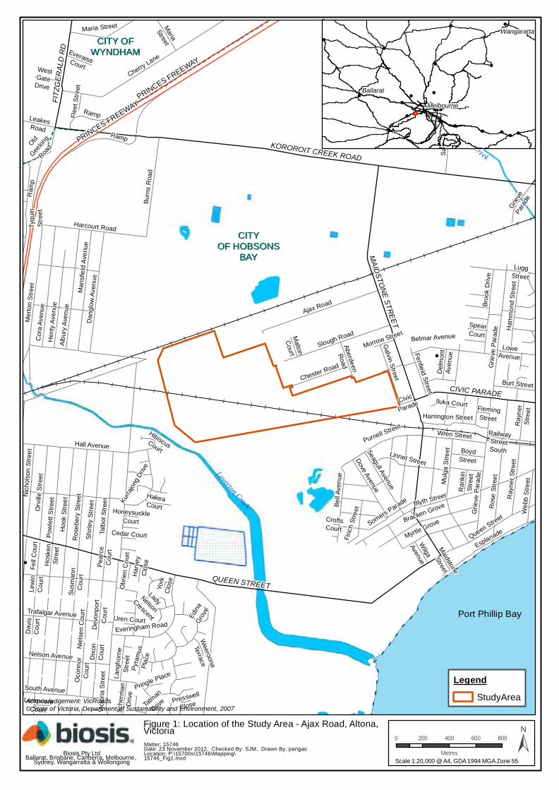
!
!
CITY OFCITY OFWYNDHAMWYNDHAM
CITYCITYOF HOBSONSOF HOBSONS
BAYBAY
Laverton Creek
Cherry Creek
Pear
ceC
ourt
York
Clo
se
CroftsCourt
Seagull Avenue
Presswell
Close
Iluka Court
Uren Court
FlemingStreet
Cedar Court
Civic
Parade
Queen StreetHoneysuckle
Court
LempriereCourt
Oco
nnor
Cou
rt
Har
vey
Clo
se
Obr
ien
Cou
rt
Flee
t Stre
et
Maidstone
Street
Susm
ann
Cou
rt
Lew
inC
ourt
Pyra
mus
Plac
e
Dav
isC
ourt
Nie
lsen
Cou
rt
SpearCourt
Pringle Place
Hall Avenue
Dev
onpo
rtC
ourt
Dix
onC
ourt
HibiscusCourt
Malton
Court
Morrow Street
OldGee
long
Road
Wilga
Avenue
Ran
kin
Stre
et
Weeroona
Terrace
HakeaCourt
Edina
Grove
EveraiseCourt
Stub
erR
oad
WestGate
Drive
LuggStreet
Del
mon
tAv
enue
LeakesRoad
Hos
ken
Stre
et
BoydStreet
Fell
Cou
rt
Sche
rman
Driv
e
Maria
Street
Gra
ham
Cou
rt
Baldwin Road
Grie
ve P
arad
e
LoweAvenue
Aberdeen
Road
Ray
ner
Stre
et
Burt Street
Grieve
Para
de
Lang
horn
eSt
reet
RailwayStreetSouth
Kurra
jong
Driv
e
Finc
h St
reet
Fenfield Street
Web
b S
treet
Somers Parade
Chester Road
Galvin Street
Wren Street
Mer
ton
Stre
et
Tatm
an
Drive
Harrington Street
Salta
Driv
e
Dove Avenue
Maria Street
Blyth Street
Ram
p
Ray
ner S
treet
Taras Avenue
LadyNelsonCrescent
Bell
Aven
ue
Myrtle Grove
Ham
mon
d S
treet
South Avenue
Broo
k D
rive
Belmar Avenue
Nelson Avenue
Purnell Street
Trafalgar Avenue
Tyqu
inSt
reet
Nic
hols
on S
treet
Orv
ille S
treet
Ramp
Pow
lett
Stre
etH
ook
Stre
et
Hen
ty A
venu
e
Ros
e St
reet
Esplanade
Burn
s R
oad
Ros
eber
y St
reet
Shirl
ey S
treet
Harcourt Road
Pinnacle Road
Talb
ot S
treet
Mul
ga S
treet
Bracken Grove
Slough Road
Everingham Road
Linnet Street
Man
sfie
ld A
venu
e
Albu
ry A
venu
e
Dan
glow
Ave
nue
Cor
a Av
enue Ajax Road
Vict
oria
Stre
et
Grie
ve P
arad
e
Ramp
Cherry Lane
KOROROIT CREEK ROAD
CIVIC PARADE
MAIDSTONE STREET
FITZG
ERAL
DRD
QUEEN STREET
PRINCES FREEWAYPRINCES FREEWAY
!
!
!
!
!
!!
!
!
!!
!
!
!
!
!
!
!
!
!!! !
!
!
!
BallaratMelbourne
Wangaratta
Acknowledgement: VicRoads© State of Victoria, Department of Sustainability and Environment, 2007
Matter: 15746Date: 23 November 2012, Checked By: SJM, Drawn By: pangasLocation: P:\15700s\15746\Mapping\15746_Fig1.mxd
LegendStudyArea
Scale 1:20,000 @ A4, GDA 1994 MGA Zone 55
0 200 400 600 800
Metres ±Biosis Pty LtdBallarat, Brisbane, Canberra, Melbourne,
Sydney, Wangarratta & Wollongong
Figure 1: Location of the Study Area - Ajax Road, Altona,Victoria
Port Phillip Bay

!(!(!(
!(!(!(!(!(!(!(!(!(!(!(!(!(!(!(!(!(
!(
GF
!(!(!(!(
!(!(
!(!(!(!(!(!(!(!(!(!(!(!(!(!(!(!(!(!(!(!(!(
!(!(!(!(!(!(!(!(!(!(!(!(!(!(!(!(!(!(!(!(!(!(!(!(!(!(!(!(!(!(!(!(!(!(!(!(!(!(!(!(!(!(!(!(!(!(!(
!(!(!(!(!(!(!(!(
!(!(!(!(!(!(!(!(!(!(!(!(!(!(!(!(!(!(!(!(!(!(!(!(!(!(!(!(!(!(!(!(
!(!(!(!(!(!(!(!(!(!(!(!(!(!(!(!(!(!(
!(!(!(!(!(!(!(
!(!(!(!(!(!(!(!(!(!(!(!(!(!(!(!(!(!(!(!(!(!(!(!(!(!(!(
!(!(!(!(!(!(!(!(!(!(!(!(!(!(!(!(!(!(!(!(!(!(!(!(!(!(!(!(!(!(!(!(!(!(!(!(!(!(!(!(!(!(!(!(!(!(!(!(!(!(!(!(!(!(!(!(!(!(!(!(!(!(!(!(!(!(!(!(!(!(!(!(!(!(!(!(!(!(!(!(!(!(!(!(!(!(!(!(!(!(!(!(!(!(!(!(!(!(!(!(!(!(!(!(!(!(!(!(!(!(!(!(!(!(!(!(!(!(!(!(!(!(!(!(!(!(!(!(!(!(!(!(!(!(!(!(!(!(!(!(!(!(!(!(!(
!(!(!(!(!(!(!(!(!(!(!(!(!(!(!(!(!(!(!(!(!(!(!(!(!(!(!(!(!(!(!(!(!(!(!(!(!(!(!(!(!(!(!(!(!(!(!(!(
!(!(!(!(
!(!(!(!(
!(
GFGFGF
!(
!(
!(!(!(
!(!(
!(!(
!(!(!(!(!(!(!(!(!(!(!(!(!(!(!(!(!(!(!(!(!(!(!(!(!(!(!(!(!(!(!(!(!(!(!(!(!(!(!(!(!(!(!(!(!(!(!(
!(!(!(!(!(!(!(!(!(!(!(
!(!(!(!(
!(!(!(
!(!(!(
!(!(!(
!(!(!(
!(
!(
!(
!(!(
!(
!(!(
!(!(!(!(!(!(!(!(
Kurrajong D
rive
Valente Street
PineDrive
Fenfield
Street
Merlow
Street
Civic
Parade
Bell
Avenue
Malton C
ourt
Morrow Street
Park ParadeDove Avenue
Seagull Avenue
Aberdeen Road
Emu
Ave
n ue
Linnet Street
Cur
lew
Ave
nue
Chester Road
Galvin Street
Purnell Street
Slough Road
Ajax Road
MAIDSTONE STREET
HZ6 HZ6
HZ6HZ2
HZ2
HZ8
HZ12
HZ5
HZ11
HZ9HZ11
HZ9
HZ10
HZ7
0 75 150 225 300
Metres
LegendStudyArea
Significant FloraGF Arching Flax-lily
!( Spiny Rice-flower
Ecological Vegetation ClassBrackish Wetland
Plains Grassy Wetland
Plains Grassland
±Matter: 15746Date: 30 November 2012, Checked by: SJM, Drawn by: PMALocation:P:\15700s\15746\Mapping\15746_Fig2_flora_fauna_report
Biosis Pty Ltd
Ballarat, Brisbane, Canberra, Melbourne, Sydney,Wangaratta & Wollongong
!
!
!
!
LavertonNorth Altona
North
Altona
Laverton
PRIN
CES
FREEWAY
RAMP
Scale: 1:6,000 @ A3
Figure 2: Ecological featureswithin Lot H, Ajax Roadproperties, Altona, Victoria
Coordinate System: GDA 1994 MGA Zone 55
Acknowledgements: Imagery (c) Nearmap 2012

Valente Street
PineDrive
Fenfield
Street
Merlow
Street
Lark Street
Civic
Parade
Eucalypt Court
Malton C
ourt
Morrow Street
Park Parade
Robin Street
Kurrajong D
rive Bell AvenueAberdeen R
oad
Linnet Street
Dove Avenue
Seagull Avenue
Chester Road
EmuA
venu
e
Galvin Street
Cur
lew
Ave
nue
Purnell Street
Slough Road
Ajax Road
MAIDSTONE STREET
0 75 150 225 300
Metres
LegendStudyArea
GSM transects by date4/01/2011
16/01/2011
20/01/2011
25/01/2011
EVC patch
±Matter: 15746Date: 30 November 2012, Checked by: SJM, Drawn by: PMA / SJPLocation:P:\15700s\15746\Mapping\15746_Fig3_GSM_targeted
Biosis Pty Ltd
Ballarat, Brisbane, Canberra, Melbourne, Sydney,Wangaratta & Wollongong
Scale: 1:6,000 @ A3
Figure 3: Golden Sun Mothtargeted survey effort, AjaxRoad, Altona, Victoria
Coordinate System: GDA 1994 MGA Zone 55
Acknowledgements: Imagery (c) Nearmap 2012