Embed Size (px)
Citation preview
FLORA AND VEGETATION OF THE
EARL GREY, IRISH BREAKFAST AND PRINCE OF WALES
PROSPECTS
Mt Holland Project
Prepared for
Kidman Resources Limited
Prepared by
Mattiske Consulting Pty Ltd
April 2017
KID1601/022/16
Mattiske Consulting Pty Ltd
Disclaimer and Limitation
This report has been prepared on behalf of and for the exclusive use of Kidman Resources Ltd,
and is subject to and issued in accordance with the agreement between Kidman Resources Ltd
and Mattiske Consulting Pty Ltd. Mattiske Consulting Pty Ltd accepts no liability or responsibility
whatsoever for it in respect of any use of or reliance upon this report by any third party.
This report is based on the scope of services defined by Kidman Resources Ltd, budgetary and
time constraints imposed by Kidman Resources Ltd, the information supplied by Kidman
Resources Ltd (and its agents), and the method consistent with the preceding.
Copying of this report or parts of this report is not permitted without the authorisation of Kidman
Resources Ltd or Mattiske Consulting Pty Ltd.
DOCUMENT HISTORY
Report Version Prepared
By Reviewed
By
Submitted to Client
Date Copies
Internal Review V1 DA EMM - -
Draft Report released for review V2 DA EMM 1/3/2017 Email
Final report V3 NM EMM 13/4/2017 Email
Final Report V4 DA EMM 20/04/2017 Email
Mattiske Consulting Pty Ltd
TABLE OF CONTENTS
Page
1. SUMMARY ...................................................................................................................................... 1
2. INTRODUCTION ............................................................................................................................. 3 2.1 Location and Scope of Proposal ................................................................................................... 3 2.2 Western Australia’s Flora – A Legislative Perspective ..................................................................... 6 2.2.1 Threatened and Priority Flora ...................................................................................................... 7 2.2.2 Threatened and Priority Ecological Communities ........................................................................... 8 2.2.3 Clearing of Native Vegetation ...................................................................................................... 8 2.3 Declared (Plant) Pest Organisms ................................................................................................. 9 2.4 Local and Regional Significance ................................................................................................. 10
3. OBJECTIVES ................................................................................................................................. 11 4. METHODS .................................................................................................................................... 12
4.1 Desktop Survey ....................................................................................................................... 13 4.2 Field Survey ............................................................................................................................ 13 4.3 Statistical Analysis of Data and Vegetation Mapping .................................................................... 14
5. DESKTOP SURVEY RESULTS ........................................................................................................... 16 5.1 Climate ................................................................................................................................... 16 5.2 Geology, Soils and Topography ................................................................................................. 16 5.3 Beard’s Vegetation Mapping ...................................................................................................... 17 5.3.1 Botanical Districts .................................................................................................................... 17 5.3.2 Vegetation Systems ................................................................................................................. 18 5.4 Pre-European Vegetation .......................................................................................................... 19 5.5 IBRA7 Biogeographical Sub-regions ........................................................................................... 22 5.6 Previous Flora and Vegetation Surveys in the Vicinity of the Earl Grey, Irish Breakfast, and Prince of
Wales Prospects ...................................................................................................................... 23 5.7 Survey of the Eastern Goldfields in the Vicinity of the Earl Grey, Irish Breakfast, and Prince of Wales
Prospects ................................................................................................................................ 28 5.8 Survey Associated with the Banded Ironstone Hill Formations in the Vicinity of the Earl Grey, Irish
Breakfast, and Prince of Wales Prospects ................................................................................... 28 5.9 Threatened Ecological Communities ........................................................................................... 30 5.10 Priority Ecological Communities ................................................................................................. 30 5.11 Nature Reserves ...................................................................................................................... 30 5.12 Flora ....................................................................................................................................... 31 5.13 Threatened and Priority Flora .................................................................................................... 31 5.14 Introduced (Exotic) Plant Species .............................................................................................. 35 5.15 Other Matters .......................................................................................................................... 35
6. FIELD SURVEY RESULTS ................................................................................................................ 36
6.1 Field Survey Limitations and Constraints .................................................................................... 36 6.2 Flora ....................................................................................................................................... 37 6.2.1 Proportion of Flora Surveyed ..................................................................................................... 38 6.2.2 Threatened and Priority Flora .................................................................................................... 39 6.2.3 Taxa with Range Extensions ..................................................................................................... 39 6.2.4 Other Taxa of Significance ........................................................................................................ 39 6.2.5 Introduced (Exotic) Plant Species .............................................................................................. 40 6.3 Statistical Analysis of Data ........................................................................................................ 41 6.4 Vegetation Mapping ................................................................................................................. 44 6.5 Area Coverage of Vegetation Communities ................................................................................. 45 6.6 Condition of the Vegetation ...................................................................................................... 46
7. DISCUSSION ................................................................................................................................ 50 8. CONCLUSIONS AND RECOMMENDATIONS ....................................................................................... 55
9. ACKNOWLEDGEMENTS .................................................................................................................. 56
10. LIST OF PERSONNEL ..................................................................................................................... 56
11. REFERENCES ................................................................................................................................ 56
Mattiske Consulting Pty Ltd
TABLES
1: Coordinates delineating the boundaries of the Earl Grey, Irish Breakfast, and Prince of Wales prospects
2: Extent of pre-European vegetation associations intersecting the Earl Grey, Irish Breakfast, and Prince of
Wales prospects
3: Extent of IBRA sub-region intersecting the Earl Grey, Irish Breakfast, and Prince of Wales prospects
4: Priority flora taxa in the vicinity of the Earl Grey, Irish Breakfast, and Prince of Wales prospects
5: Introduced plant species in the vicinity of the Earl Grey, Irish Breakfast, and Prince of Wales prospects
6: Potential flora and vegetation survey limitations for the Earl Grey, Irish Breakfast, and Prince of Wales
prospects
7: Locations of taxa with extensions to their known range, recorded within the Earl Grey, Irish Breakfast,
and Prince of Wales prospects
8: Occurrence of mapped vegetation communities within the Earl Grey, Irish Breakfast and Prince of Wales
prospects
9: Total area coverage of each vegetation community mapped across the Earl Grey, Irish Breakfast and
Prince of Wales prospects
10: Area coverage of each vegetation community within the Earl Grey, Irish Breakfast and Prince of Wales
prospects
FIGURES
1: Project area locality
2: Tenements
3: Rainfall and temperature data for Hyden
4: Pre-European vegetation
5: IBRA regions
6: PECs, nature reserve, threatened and priority flora
7: Average randomised species accumulation curve
8: Dendrogram of the 52 survey quadrats established across the Earl Grey, Irish Breakfast, Prince of Wales
and Van Uden prospects
9.1: Earl Grey and Irish Breakfast vegetation
9.2: Prince of Wales vegetation
APPENDICES
A: Legislative protection for Western Australia’s Environment
B: Location of vegetation survey quadrats established in the Earl Grey, Irish Breakfast and Prince of Wales
prospects, October/November 2016
Mattiske Consulting Pty Ltd
C: Vascular plant species recorded from the desktop assessment and within the Earl Grey, Irish Breakfast,
and Prince of Wales prospects, October/November 2016
D: Assessment of threatened and priority flora potentially present in the Earl Grey, Irish Breakfast, and
Prince of Wales prospects
E: Summary of vascular plant species recorded in each survey quadrat in the Earl Grey, Irish Breakfast and
Prince of Wales prospects in October & November 2016
F: Locations of threatened and priority flora recorded within the Earl Grey, Irish Breakfast and Prince of
Wales prospects
G: DPaW Threatened and priority flora report forms
H: Summary of vascular plant species recorded in each vegetation community in the Earl Grey, Irish
Breakfast and Prince of Wales prospects
I: Summary of vegetation communities defined in the Earl Grey, Irish Breakfast and Prince of Wales
prospects
ABBREVIATIONS
The following abbreviations are used throughout this document:
BAM Act Biosecurity and Agriculture Management Act 2007
BOM Commonwealth Bureau of Meteorology
DAFWA Department of Agriculture and Food, Western Australia
DotEE Department of the Environment and Energy
DPaW Department of Parks and Wildlife
EPA Environment Protection Authority
EPBC Act Environment Protection and Biodiversity Conservation Act 1999
ESCAVI Executive Steering Committee for Australian Vegetation Information
IBRA Interim Biogeographic Regionalisation for Australia
Kidman Kidman Resources Ltd
Mattiske Mattiske Consulting Pty Ltd
NVIS National Vegetation Information System
PEC Priority Ecological Community
PRIMER Plymouth Routines in Multivariate Ecological Research
TEC Threatened Ecological Community
TSSC Western Australian Threatened Species Scientific Committee
WAH Western Australian Herbarium
WAOL Western Australian Organism List
1. ____________________________________________________________________________________________
Mattiske Consulting Pty Ltd
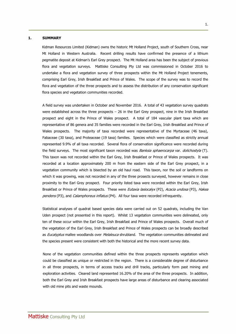
1. SUMMARY
Kidman Resources Limited (Kidman) owns the historic Mt Holland Project, south of Southern Cross, near
Mt Holland in Western Australia. Recent drilling results have confirmed the presence of a lithium
pegmatite deposit at Kidman’s Earl Grey prospect. The Mt Holland area has been the subject of previous
flora and vegetation surveys. Mattiske Consulting Pty Ltd was commissioned in October 2016 to
undertake a flora and vegetation survey of three prospects within the Mt Holland Project tenements,
comprising Earl Grey, Irish Breakfast and Prince of Wales. The scope of the survey was to record the
flora and vegetation of the three prospects and to assess the distribution of any conservation significant
flora species and vegetation communities recorded.
A field survey was undertaken in October and November 2016. A total of 43 vegetation survey quadrats
were established across the three prospects – 26 in the Earl Grey prospect, nine in the Irish Breakfast
prospect and eight in the Prince of Wales prospect. A total of 184 vascular plant taxa which are
representative of 86 genera and 35 families were recorded in the Earl Grey, Irish Breakfast and Prince of
Wales prospects. The majority of taxa recorded were representative of the Myrtaceae (46 taxa),
Fabaceae (30 taxa), and Proteaceae (19 taxa) families. Species which were classified as strictly annual
represented 9.9% of all taxa recorded. Several flora of conservation significance were recorded during
the field surveys. The most significant taxon recorded was Banksia sphaerocarpa var. dolichostyla (T).
This taxon was not recorded within the Earl Grey, Irish Breakfast or Prince of Wales prospects. It was
recorded at a location approximately 200 m from the eastern side of the Earl Grey prospect, in a
vegetation community which is bisected by an old haul road. This taxon, nor the soil or landforms on
which it was growing, was not recorded in any of the three prosects surveyed, however remains in close
proximity to the Earl Grey prospect. Four priority listed taxa were recorded within the Earl Grey, Irish
Breakfast or Prince of Wales prospects. These were Eutaxia lasiocalyx (P2), Acacia undosa (P3), Hakea
pendens (P3), and Calamphoreus inflatus (P4). All four taxa were recorded infrequently.
Statistical analyses of quadrat based species data were carried out on 52 quadrats, including the Van
Uden prospect (not presented in this report). Whilst 13 vegetation communities were delineated, only
ten of these occur within the Earl Grey, Irish Breakfast and Prince of Wales prospects. Overall much of
the vegetation of the Earl Grey, Irish Breakfast and Prince of Wales prospects can be broadly described
as Eucalyptus mallee woodlands over Melaleuca shrubland. The vegetation communities delineated and
the species present were consistent with both the historical and the more recent survey data.
None of the vegetation communities defined within the three prospects represents vegetation which
could be classified as unique or restricted in the region. There is a considerable degree of disturbance
in all three prospects, in terms of access tracks and drill tracks, particularly form past mining and
exploration activities. Cleared land represented 16.20% of the area of the three prospects. In addition,
both the Earl Grey and Irish Breakfast prospects have large areas of disturbance and clearing associated
with old mine pits and waste mounds.

2. ____________________________________________________________________________________________
Mattiske Consulting Pty Ltd
The Earl Grey, Irish Breakfast and Prince of Wales prospects are situated wholly within the buffer of the
Ironcap Hills Vegetation Complexes (Mt Holland, Middle, North and South Ironcap Hills, Digger Rock and
Hatter Hill) (banded ironstone), a Priority 3 ecological community. All three prospects are located
adjacent to the western boundary of the PEC buffer. Given that the vegetation present in all three
prospects was typical of the region and that there were no banded ironstone hills outcropping present, it
is likely that impacts to the PEC are peripheral and minor in their extent.
The principal issue with respect to the flora and vegetation surveyed is in relation to the presence of
Banksia sphaerocarpa var. dolichostyla (T) in the vicinity of the Earl Grey prospect. It would be
appropriate, in the event of future mine development, to put in place a management plan to minimise
impacts to this species and the associated vegetation.
3. ____________________________________________________________________________________________
Mattiske Consulting Pty Ltd
2. INTRODUCTION
Kidman Resources Limited (Kidman) owns the historic Mt Holland Project, south of Southern Cross, near
Mt Holland in Western Australia. Recent drilling results have confirmed the presence of a lithium
pegmatite deposit at Kidman’s Earl Grey prospect, located west of the historic Bounty pit and processing
plant. Two other prospects, Irish Breakfast and Prince of Wales, located north of Earl Grey, also may
have future resource potential. . The Mt Holland area has been the subject of previous flora and
vegetation surveys. In 2006, Craig (2006) completed a rare and priority flora survey of the Bounty mine
area for Nickel Australia Limited. The survey encompassed the Earl Grey, Irish Breakfast and Prince of
Wales prospects. In September 2016, Native Vegetation Solutions (2016a) completed a targeted
threatened flora survey of the Earl Grey prospect.
Mattiske Consulting Pty Ltd (Mattiske) was commissioned in October 2016 to undertake a flora and
vegetation survey of the Earl Grey, Irish Breakfast and Prince of Wales prospects. Whilst this report
focuses on these three prospects, both the desktop assessment and statistical analysis of field survey
data used to derive vegetation communities incorporated data from the Van Uden prospect, located 10
km south-west of the Earl Grey prospect.
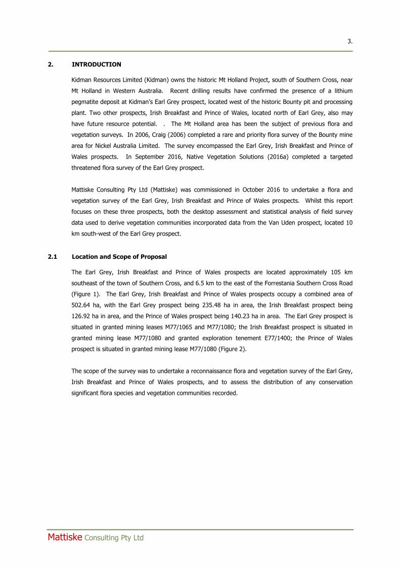
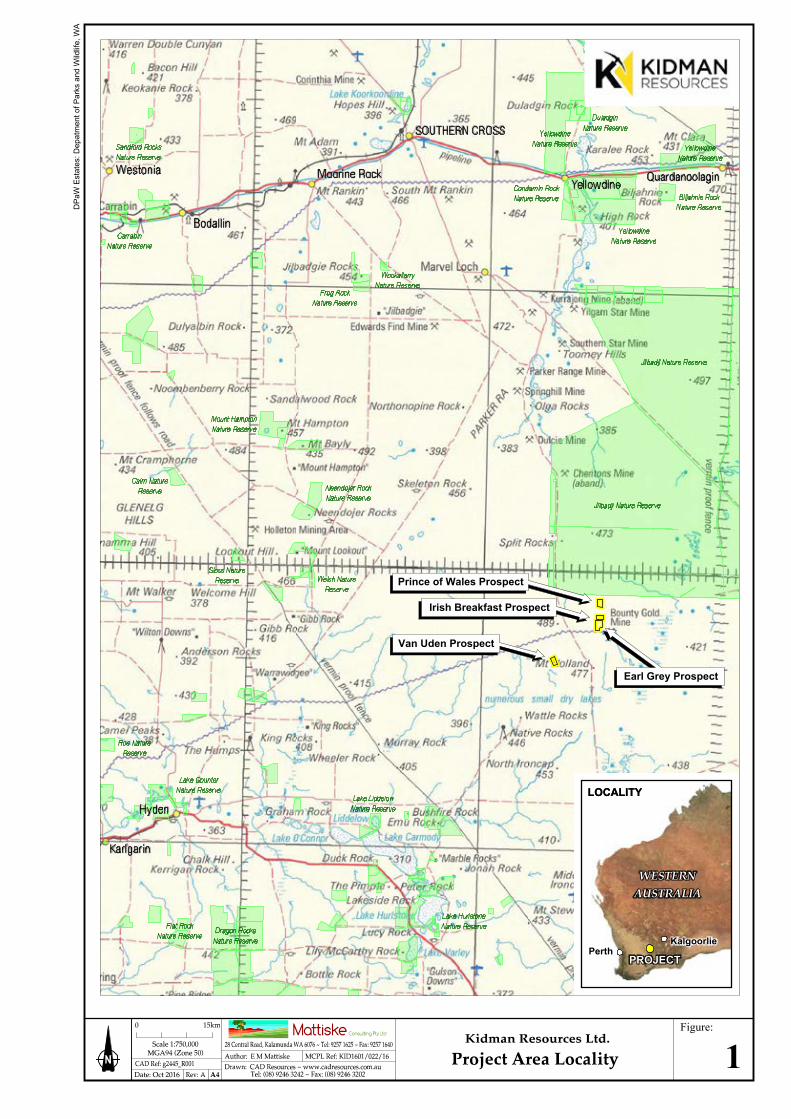
2.1 Location and Scope of Proposal
The Earl Grey, Irish Breakfast and Prince of Wales prospects are located approximately 105 km
southeast of the town of Southern Cross, and 6.5 km to the east of the Forrestania Southern Cross Road
(Figure 1). The Earl Grey, Irish Breakfast and Prince of Wales prospects occupy a combined area of
502.64 ha, with the Earl Grey prospect being 235.48 ha in area, the Irish Breakfast prospect being
126.92 ha in area, and the Prince of Wales prospect being 140.23 ha in area. The Earl Grey prospect is
situated in granted mining leases M77/1065 and M77/1080; the Irish Breakfast prospect is situated in
granted mining lease M77/1080 and granted exploration tenement E77/1400; the Prince of Wales
prospect is situated in granted mining lease M77/1080 (Figure 2).
The scope of the survey was to undertake a reconnaissance flora and vegetation survey of the Earl Grey,
Irish Breakfast and Prince of Wales prospects, and to assess the distribution of any conservation
significant flora species and vegetation communities recorded.
DPa
W E
stat
es: D
epat
men
t of P
arks
and
Wild
life,
WA
Earl Grey Prospect
Van Uden Prospect
Prince of Wales Prospect
Irish Breakfast Prospect
LOCALITY
Figure:
1
KalgoorliePerth
PROJECT
LOCALITY
750000mE 755000mE 760000mE
6440
000m
N64
4500
0mN
6450
000m
N
750000mE 755000mE 760000mE
6440
000m
N64
4500
0mN
6450
000m
N
Aeria
l: La
ndga
te (M
arch
201
1) ~
Ten
emen
ts: D
MP
(Oct
ober
201
6) ~
DPa
W E
stat
es: D
epat
men
t of P
arks
and
Wild
life,
WA
Van Uden Prospect
Irish Breakfast Prospect
Prince of Wales Prospect
Earl Grey Prospect
JilbadjiNature Reserve
Figure:
2
6. ____________________________________________________________________________________________
Mattiske Consulting Pty Ltd
2.2 Western Australia’s Flora – A Legislative Perspective
Western Australia has a unique and diverse flora, and is recognised as one of the world’s 34 biodiversity
hotspots (Myers et al. 2000). In this context, Western Australia possesses a high degree of species
richness and endemism. This is particularly pronounced in the south-west region of the state. The
Department of Parks and Wildlife (DPaW) flora statistics indicate that there are currently over 12,000
native plant species known to occur within Western Australia (DPaW 2017a). Scientific knowledge of
many of these species is limited.
The legislative protection of flora within Western Australia is principally governed by four Acts. These
are the:
Biodiversity Conservation Act 2016 (WA);
Wildlife Conservation Act 1950 (WA);
Environmental Protection Act 1986 (WA); and
Environment Protection and Biodiversity Conservation Act 1999 (Cth).
In December 2016, several parts of the new Biodiversity Conservation Act 2016 were proclaimed. The
Biodiversity Conservation Act 2016 is ultimately intended to replace the Sandalwood Act 1929 and the
Wildlife Conservation Act 1950. At the time of compiling this report, the Biodiversity Conservation Act
2016 does not fully replace the Sandalwood Act 1929 and the Wildlife Conservation Act 1950. Flora,
threatened species listings and controls over the taking and keeping of native species, are still covered
under the Wildlife Conservation Act 1950. Where reference is made to the Wildlife Conservation Act
1950, this also includes the Biodiversity Conservation Act 2016.
The unique flora of Western Australia is potentially under threat due to historical clearing practices
associated with agricultural, mining and human habitation activities. As a consequence of these
historical clearing practices a number of flora species have become threatened or have the potential to
become threatened as their habitat is impacted by human activity. In addition, some areas of the State
have been affected by past clearing practices such that entire ecological communities are under threat.
The following sections describe these threatened and priority flora and ecological communities, and
outline the legislative protection afforded to them.
At the State level, the Wildlife Conservation Act 1950 provides for taxa of native flora (and fauna) to be
specially protected because they are subject to identifiable threats. Protection of these taxa has been
identified as being warranted because they may become extinct, are threatened, or are otherwise in
need of special protection. Ecological communities that are deemed to be threatened are afforded
protection under the Environmental Protection Act 1986. Listings of threatened species and
communities are reviewed annually by the Western Australian Threatened Species Scientific Committee
(TSSC), which is a body appointed by the Minister for the Environment and supported by the DPaW.
The TSSC reviews threatened and specially protected flora (and fauna) listings on an annual basis.
Recommendation for additions or deletions to the listings of specially protected flora (and fauna) is made
to the Minister for the Environment by the TSSC, via the Director General of the DPaW, and the WA
7. ____________________________________________________________________________________________
Mattiske Consulting Pty Ltd
Conservation Commission. Under Schedule 1 of the Wildlife Conservation Act 1950, the Minister for the
Environment may declare a class or description of flora to be threatened flora throughout the State, by
notice published in the Government Gazette (DPaW 2017b).
At the Commonwealth level, under the Environment Protection and Biodiversity Conservation Act 1999, a
nomination process exists to list a threatened species or ecological community. Additions or deletions to
the lists of threatened species and communities are made by the Minister for the Environment and
Energy, on advice from the Federal Threatened Species Scientific Committee. Environment Protection
and Biodiversity Conservation Act 1999 lists of threatened flora and ecological communities are
published on the Department of the Environment and Energy (DotEE) website (2017a, 2017b).
2.2.1 Threatened and Priority Flora
Flora within Western Australia that is considered to be under threat may be classed as either threatened
flora or priority flora. Where flora has been gazetted as threatened flora under the Wildlife Conservation
Act 1950, it is an offence “to take” such flora without the written consent of the Minister. The Wildlife
Conservation Act 1950 states that “to take” flora includes to gather, pluck, cut, pull up, destroy, dig up,
remove or injure the flora or to cause or permit the same to be done by any means.
Priority flora constitute species which are considered to be under threat, but for which there is
insufficient information available concerning their distribution and/or populations to make a proper
evaluation of their conservation status. Such species are considered to potentially be under threat, but
do not have legislative protection afforded under the Wildlife Conservation Act 1950. The DPaW
categorises priority flora according to their conservation priority, using four categories, P1 to P4, to
denote the conservation priority status of such species, with P1 listed species being the most threatened,
and P4 the least. Priority flora species are regularly reviewed, and may have their priority status
changed when more information on the species becomes available. Appendix A1 sets out definitions of
both threatened and priority flora (DPaW 2017c).
At the Commonwealth level, under the Environment Protection and Biodiversity Conservation Act 1999,
threatened species can be listed as extinct, extinct in the wild, critically endangered, endangered,
vulnerable, or conservation dependent, by the Commonwealth Minister for the Environment and Energy.
Refer to Appendix A2 for a description of each of these categories of threatened species. Under the
Environment Protection and Biodiversity Conservation Act 1999, a person must not take an action that
has or will have a significant impact on a listed threatened species without approval from the
Commonwealth Minister for the Environment, unless those actions are not prohibited under the Act.
The current Environment Protection and Biodiversity Conservation Act 1999 list of threatened flora may
be found on the DotEE (2017a) website.
8. ____________________________________________________________________________________________
Mattiske Consulting Pty Ltd
2.2.2 Threatened and Priority Ecological Communities
An ecological community is defined as a naturally occurring biological assemblage that occurs in a
particular type of habitat composed of specific abiotic and biotic factors. At the State level, ecological
communities may be considered as threatened once they have been identified as such by the Western
Australian Threatened Ecological Communities Scientific Advisory Committee. A threatened ecological
community (TEC) is defined, under the Environmental Protection Act 1986, as an ecological community
listed, designated or declared under a written law or a law of the Commonwealth as threatened,
endangered or vulnerable. There are four State categories of threatened ecological communities, or
TECs: presumed totally destroyed (PD); critically endangered (CR); endangered (EN); and vulnerable
(VU) (DPaW 2017d). A description of each of these categories of TECs is presented in Appendix A3.
Threatened ecological communities are gazetted as such (DPaW 2017e).
At the Commonwealth level, some Western Australian TECs are listed as threatened, under the
Environment Protection and Biodiversity Conservation Act 1999. Under the Environment Protection and
Biodiversity Conservation Act 1999, a person must not take an action that has or will have a significant
impact on a listed TEC without approval from the Commonwealth Minister for the Environment and
Energy, unless those actions are not prohibited under the Act. A description of each of these categories
of TECs is presented in Appendix A4. The current Environment Protection and Biodiversity Conservation
Act 1999 list of threatened ecological communities can be located on the DotEE (2017b) website.
Ecological communities identified as threatened, but not listed as TECs, can be classified as priority
ecological communities (PECs). These communities are under threat, but there is insufficient
information available concerning their distribution to make a proper evaluation of their conservation
status. The DPaW categorises PECs according to their conservation priority, using five categories, P1 to
P5, to denote the conservation priority status of such ecological communities, with P1 communities being
the most threatened and P5 the least. Appendix A5 sets out definitions of priority ecological
communities (DPaW 2017d). A list of current priority ecological communities can be viewed at the
DPaW (2017f) website.
2.2.3 Clearing of Native Vegetation
Under the Environmental Protection Act 1986, the clearing of native vegetation requires a permit to do
so, from the Department of Environment Regulation or the Department of Mines and Petroleum, unless
that clearing is exempted under specific provisions listed in Schedule 6 of the Act, or are prescribed in
the Environmental Protection (Clearing of Native Vegetation) Regulations 2004. Under the
Environmental Protection Act 1986, “native vegetation” means indigenous aquatic or terrestrial
vegetation, and includes dead vegetation unless that dead vegetation is of a class declared by regulation
to be excluded from this definition but does not include vegetation in a plantation. Under the
Environmental Protection Act 1986, Section 51A, “clearing” means the killing or destruction of, the
removal of, the severing or ringbarking of trunks or stems of, or the doing of any other substantial
damage to, some or all of the native vegetation in an area, and includes the draining or flooding of land,
9. ____________________________________________________________________________________________
Mattiske Consulting Pty Ltd
the burning of vegetation, the grazing of stock, or any other act or activity, that causes any of the
aforementioned consequences or results.
Under the Environmental Protection Act 1986, ten principles are set out, under which native vegetation
should not be cleared. These principles state that native vegetation should not be cleared, if:
a. it comprises a high level of biological diversity;
b. it comprises the whole or a part of, or is necessary for the maintenance of, a significant habitat
for fauna indigenous to Western Australia;
c. it includes, or is necessary for the continued existence of, threatened flora;
d. it comprises the whole or a part of, or is necessary for the maintenance of, a threatened
ecological community;
e. it is significant as a remnant of native vegetation in an area that has been extensively cleared;
f. it is growing in, or in association with, an environment associated with a watercourse or
wetland;
g. the clearing of the vegetation is likely to cause appreciable land degradation;
h. the clearing of the vegetation is likely to have an impact on the environmental values of any
adjacent or nearby conservation area;
i. the clearing of the vegetation is likely to cause deterioration in the quality of surface or
underground water; or
j. the clearing of the vegetation is likely to cause, or exacerbate, the incidence or intensity of
flooding.
The Environmental Protection (Clearing of Native Vegetation) Regulations 2004, under Regulation 5, sets
out prescribed clearing actions that do not require a clearing permit, as defined in Section 51C of the
Environmental Protection Act 1986. However, exemptions under these Regulations do not apply in
Environmentally Sensitive Areas (ESAs).
Under the Environmental Protection (Clearing of Native Vegetation) Regulations 2004, under Regulation
6 – “Environmentally sensitive areas” include “the area covered by vegetation within 50 m of threatened
flora, to the extent to which the vegetation is continuous with the vegetation in which the threatened
flora is located”. Similarly, “the area covered by a threatened ecological community” is listed as an
environmentally sensitive area under Regulation 6.
2.3 Declared (Plant) Pest Organisms
The Biosecurity and Agriculture Management Act 2007 (BAM Act), Section 22, makes provision for a
plant taxon to be listed as a declared pest organism in respect to parts of, or the entire State. According
to the BAM Act, a declared pest is defined as a prohibited organism (Section 12), or an organism for
which a declaration under section 22 (2) of the Act is in force.
10. ____________________________________________________________________________________________
Mattiske Consulting Pty Ltd
Under section 26 (1) of the BAM Act, a person who finds a declared plant pest must report, in
accordance with subsection (2), the presence or suspected presence of the declared pest to the Director
General or an inspector of the Department of Agriculture and Food Western Australia.
Under the Biosecurity and Agriculture Management Regulations 2013, declared plant pests are placed in
one of three control categories, C1 (exclusion), C2 (eradication) or C3 (management), which determines
the measures of control which apply to the declared pest (Appendix A6). According to section 30 (3) of
the BAM Act, the owner or occupier of land, or a person who is conducting an activity on the land, must
take the prescribed control measures to control the declared pest if it is present on the land.
The current listing of declared pest organisms and their control category is available on the Western
Australian Organism List (WAOL), at the Biosecurity and Agriculture Management website of the
Department of Agriculture and Food Western Australia (DAFWA 2017).
2.4 Local and Regional Significance
Flora or vegetation may be locally or regionally significant in addition to statutory listings by the State or
Federal Government. Under the Environmental Factor Guideline: Flora and Vegetation (EPA 2016a), flora
may be considered significant for a range of reasons, including, but not limited to the following:
being identified as threatened or priority species;
locally endemic or associated with a restricted habitat type (e.g. surface water or groundwater
dependent ecosystems);
new species or anomalous features that indicate a potential new species;
representative of the range of a species (particularly, at the extremes of a range, recently
discovered range extensions, or isolated outliers of the main range);
unusual species, including restricted subspecies, varieties or naturally occurring hybrids; or
relictual status, being representative of taxonomic groups that no longer occur widely in the
broader landscape.
Under the Environmental Factor Guideline: Flora and Vegetation (EPA 2016a), vegetation may be
considered significant for a range of reasons, including, but not limited to the following:
being identified as threatened or priority ecological communities;
restricted distribution;
degree of historical impact from threatening processes;
a role as a refuge; or
providing an important function required to maintain ecological integrity of a significant
ecosystem.
11. ____________________________________________________________________________________________
Mattiske Consulting Pty Ltd
3. OBJECTIVES
The aim of this survey was to complete a flora and vegetation survey of the Earl Grey, Irish Breakfast
and Prince of Wales prospects. Specifically, the objectives included:
Undertake a desktop assessment to evaluate the botanical values of the local and broader area
associated with the Earl Grey, Irish Breakfast and Prince of Wales prospects to identify any
matters of botanical or conservation significance;
Review previous literature and current databases associated with the Earl Grey, Irish Breakfast
and Prince of Wales prospects;
On the basis of the reviews, provide summaries to assist in the assessment of the potential
range of values and the potential for conservation significant species and communities;
Undertake botanical data collection in quadrats that are representative of all potential
vegetation communities within the survey area of sufficient detail to permit appropriate
statistical analyses;
Collect and identify the vascular plant species present in vegetation survey quadrats, as well as
opportunistically, within the Earl Grey, Irish Breakfast and Prince of Wales prospects;
Record visual observations on the fire regimes, grazing pressures and overall health of the
vegetation to allow for an assessment of the overall condition of the flora and vegetation within
the Earl Grey, Irish Breakfast and Prince of Wales prospects;
Identify and record the locations of any declared pest organisms within the Earl Grey, Irish
Breakfast and Prince of Wales prospects;
Review the conservation status of the vascular plant species recorded by reference to current
literature and current listings by the DPaW (2017g) and plant collections held at the Western
Australian State Herbarium, and listed by the Department of the Environment (DotEE 2017a)
under the Environment Protection and Biodiversity Conservation Act 1999;
Define and prepare a vegetation map of the vegetation communities within the Earl Grey, Irish
Breakfast and Prince of Wales prospects;
Assess the condition of the vegetation communities within the Earl Grey, Irish Breakfast and
Prince of Wales prospects;
Evaluate the distributions of any conservation significant flora recorded within the Earl Grey,
Irish Breakfast and Prince of Wales prospects and evaluate their regional significance;
Provide descriptions of the vegetation communities present within the Earl Grey, Irish Breakfast
and Prince of Wales prospects and evaluate their regional significance; and
Prepare a report summarising the findings.
12. ____________________________________________________________________________________________
Mattiske Consulting Pty Ltd
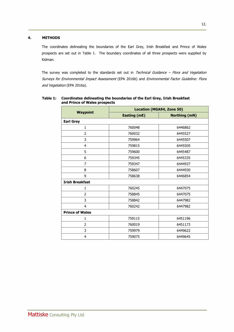
4. METHODS
The coordinates delineating the boundaries of the Earl Grey, Irish Breakfast and Prince of Wales
prospects are set out in Table 1. The boundary coordinates of all three prospects were supplied by
Kidman.
The survey was completed to the standards set out in Technical Guidance – Flora and Vegetation
Surveys for Environmental Impact Assessment (EPA 2016b) and Environmental Factor Guideline: Flora
and Vegetation (EPA 2016a).
Table 1: Coordinates delineating the boundaries of the Earl Grey, Irish Breakfast and Prince of Wales prospects
Waypoint Location (MGA94, Zone 50)
Easting (mE) Northing (mN)
Earl Grey
1 760048 6446862
2 760032 6445527
3 759964 6445507
4 759815 6445505
5 759600 6445487
6 759345 6445335
7 759347 6444937
8 758607 6444930
9 758638 6446854
Irish Breakfast
1 760245 6447075
2 758845 6447075
3 758842 6447982
4 760242 6447982
Prince of Wales
1 759115 6451196
2 760019 6451173
3 759979 6449622
4 759075 6449645
13. ____________________________________________________________________________________________
Mattiske Consulting Pty Ltd
4.1 Desktop Survey
The desktop assessment for the Earl Grey, Irish Breakfast and Prince of Wales prospects was
undertaken using the resources of the DPaW (2007-, 2017b, 2017e, 2017f, 2017g) and DotEE (2017a,
2017b, 2017c) databases, along with historic surveys in the immediate vicinity (Craig 2006, Native
Vegetation Solutions 2014, Native Vegetation Solutions 2016a) or the broader region (Gibson 2004a).
The search parameters used were a 20 km radius ‘by circle’ at 759408 mE, 6448103 mN, (MGA94 zone
50). The Earl Grey and Prince of Wales prospects are located 0.25 km south and 1.7 km north
respectively of the Irish Breakfast prospect. The Van Uden prospect is located 10 km south-west of the
Earl Grey prospect (Figure 2).
These databases were utilised to identify the possible occurrence of threatened and priority flora,
threatened and priority ecological communities and any other matters protected under the Environment
Protection and Biodiversity Conservation Act 1999 within the vicinity of the Earl Grey, Irish Breakfast and
Prince of Wales prospects. Data from the Van Uden search area were included to provide a more
comprehensive list of species of conservation significance in the project vicinity.
4.2 Field Survey
The assessment of the flora and vegetation of the Earl Grey, Irish Breakfast and Prince of Wales
prospects (Figure 2) was undertaken by two experienced botanists from Mattiske, from the 24th to 26th
October 2016 and the 9th to 10th November 2016. All botanists held valid collection licences to collect
flora for scientific purposes, issued under the Wildlife Conservation Act 1950. Additionally, one botanist
held a valid permit to take Declared Rare Flora, issued under the Wildlife Conservation Act 1950.
The coordinates delineating the boundaries of the Earl Grey, Irish Breakfast and Prince of Wales
prospects were supplied by Kidman (Table 1). Aerial photographic maps at a 1:4,000 scale of the Earl
Grey and Irish Breakfast prospects, and 1:5,000 of the Prince of Wales prospect were prepared by CAD
Resources of Carine, Western Australia. To sample all the apparent vegetation types across the three
prospects, the location of vegetation survey quadrats was made primarily on the basis of aerial
photographic maps. Additional sites were selected in situ, based on observations of vegetation
communities during the field survey. Wherever possible, replicate vegetation survey quadrats were
established in the same but discontinuous vegetation community types. In addition to data recorded
from vegetation survey quadrats, a more comprehensive species inventory of the three prospects was
achieved using supplementary survey techniques - opportunistic collections, relevés and traverses.
A total of 43 vegetation survey quadrats were established and surveyed across the three prospects.
Twenty six quadrats were established within the Earl Grey prospect, nine within the Irish Breakfast
prospect and eight within the Prince of Wales prospect. All vegetation survey quadrats measured 20 m x
20 m in size. In situations where vegetation community shape (e.g. drainage channels) precluded
establishing quadrats of the standard dimension, an area of equivalent size (i.e. 400 m2) was surveyed.
The locations of all survey quadrats are set out in Appendix B.
14. ____________________________________________________________________________________________
Mattiske Consulting Pty Ltd
The flora and vegetation was described and sampled systematically at each vegetation survey quadrat,
and additional opportunistic collecting was undertaken wherever previously unrecorded plants were
observed. At each vegetation survey quadrat, the following floristic and environmental parameters were
recorded:
GPS location (GDA94 datum);
soil type, colour and any additional observations;
local site topography;
presence of any outcropping rocks and their type;
aspect of the hill-slopes;
percentage of litter cover (logs, twigs and/or leaves);
percentage of bare ground;
time since fire;
condition of the vegetation, based on Trudgen’s (1988) condition ratings (Appendix A7); and
alive and dead percentage of foliage cover and average height of each species recorded.
All plant specimens collected during the field survey were dried and processed in accordance with the
requirements of the Western Australian Herbarium (WAH). All plant specimens were identified through
comparisons with pressed specimens housed at the Mattiske herbarium and WAH. Where appropriate,
plant taxonomists with specialist skills were consulted. Nomenclature of the species recorded is in
accordance with the WAH (DPaW 2017g).
4.3 Statistical Analysis of Data and Vegetation Mapping
A species accumulation curve, based on accumulated species versus number of quadrats surveyed was
prepared, to evaluate the level of adequacy of the survey effort. The species accumulation curve was
based on the species accumulation analysis of Colwell (2013).
Plymouth Routines in Multivariate Ecological Research version 6 (PRIMER v6) statistical analysis software
was used to analyse species-by-site data and discriminate sites on the basis of their species composition
(Clarke and Gorley 2006). To down weight the relative contributions of quantitatively dominant species
a 4th root transformation was applied to the data set. Introduced species, singletons (species recorded
at only one site) and specimens that were not identified down to the species level were excluded from
the analysis. Annuals were removed from the data in analysis due to the likelihood of substantial
differences between years based on seasonality of local rainfall events. Computation of similarity
matrices was based on the Bray-Curtis similarity measure. Transformed data were analysed using a
series of multivariate analysis routines including Hierarchical Clustering (CLUSTER), Similarity Profile
(SIMPROF) and Similarity Percentages (SIMPER). Results were used to inform and support
interpretation of aerial photography and delineation of individual vegetation communities.

15. ____________________________________________________________________________________________
Mattiske Consulting Pty Ltd
Vegetation descriptions were based on Alpin’s (1979) modification of the vegetation classification system
of Specht (1970), to align with the National Vegetation Information Systems (NVIS). Vegetation
communities were described at the association level of the NVIS classification framework, as defined by
the Executive Steering Committee for Australian Vegetation Information (ESCAVI 2003).
16. ____________________________________________________________________________________________
Mattiske Consulting Pty Ltd
5. DESKTOP SURVEY RESULTS
5.1 Climate
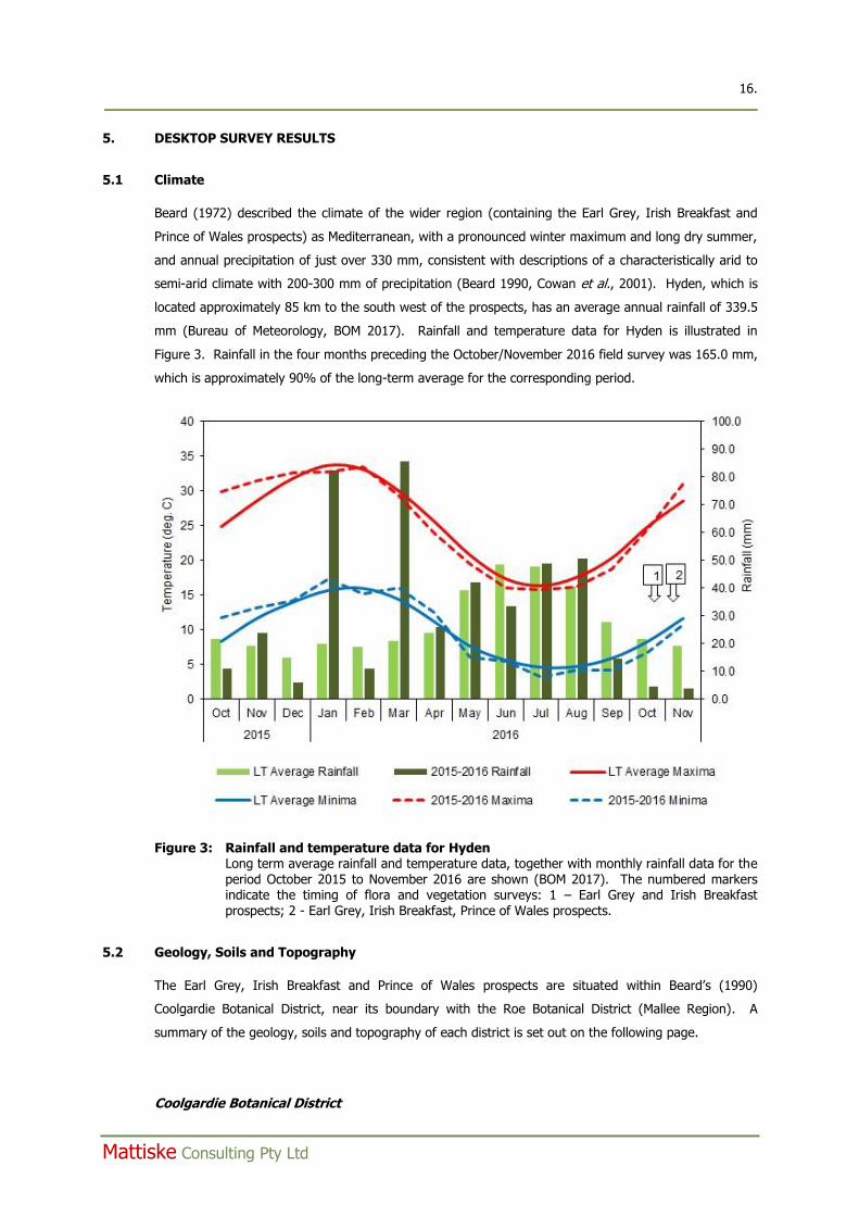
Beard (1972) described the climate of the wider region (containing the Earl Grey, Irish Breakfast and
Prince of Wales prospects) as Mediterranean, with a pronounced winter maximum and long dry summer,
and annual precipitation of just over 330 mm, consistent with descriptions of a characteristically arid to
semi-arid climate with 200-300 mm of precipitation (Beard 1990, Cowan et al., 2001). Hyden, which is
located approximately 85 km to the south west of the prospects, has an average annual rainfall of 339.5
mm (Bureau of Meteorology, BOM 2017). Rainfall and temperature data for Hyden is illustrated in
Figure 3. Rainfall in the four months preceding the October/November 2016 field survey was 165.0 mm,
which is approximately 90% of the long-term average for the corresponding period.
Figure 3: Rainfall and temperature data for Hyden Long term average rainfall and temperature data, together with monthly rainfall data for the period October 2015 to November 2016 are shown (BOM 2017). The numbered markers indicate the timing of flora and vegetation surveys: 1 – Earl Grey and Irish Breakfast prospects; 2 - Earl Grey, Irish Breakfast, Prince of Wales prospects.
5.2 Geology, Soils and Topography
The Earl Grey, Irish Breakfast and Prince of Wales prospects are situated within Beard’s (1990)
Coolgardie Botanical District, near its boundary with the Roe Botanical District (Mallee Region). A
summary of the geology, soils and topography of each district is set out on the following page.
Coolgardie Botanical District
17. ____________________________________________________________________________________________
Mattiske Consulting Pty Ltd
Geologically, the area consists of Proterozoic granite and gneiss of the Fraser Range block and Archaean
granite with infolded volcanics and meta sediments of the Yilgarn block. Major greenstone belts provide
the major hilly topography of the district (Beard 1990). Valley areas consist of quaternary duplex soils
and chains of playa lakes. Upper levels in the landscape comprise the eroded remnants of a lateritic
duricrust, yielding yellow sandplains, gravelly sandplains and laterite breakaways (Cowan et al. 2001).
Roe Botanical District
Geologically, the area consists of Archean and Proterozoic granites overlain in the east by Tertiary
sediments (Beard 1990). The main surface soils consist of clays and silts underlain by Kankar, exposed
granite, sandplains and laterite pavements (Beecham and Danks 2001).
In more recent times mapping of soils and landscapes has become available at a greater level of detail.
The Department of Agriculture, in its “Soil-landscapes of Western Australia’s Rangelands and Arid
Interior” (Tille 2006), described a range of soil-landscape mapping units. The Earl Grey, Irish Breakfast
and Prince of Wales prospects are situated within Tille’s (2006) Southern Cross Zone (Zone 261). Tille
(2006) describes the soils of the Southern Cross Zone as comprising undulating plains and uplands (with
some salt lakes and low hills) on deeply weathered mantle, colluvium and alluvium over greenstone and
granitic rocks of the Yilgarn Craton. The Southern Cross zone comprises calcareous loamy earths, red
and yellow loamy earths and alkaline deep and shallow sandy duplexes with some yellow sandy earths,
salt lake soils, yellow deep sands and red shallow loamy duplexes. The Southern Cross zone is located
in the eastern Wheatbelt/south-western Goldfields between Bullfinch and Mt Holland.
5.3 Beard’s Vegetation Mapping
5.3.1 Botanical Districts
The Earl Grey, Irish Breakfast and Prince of Wales prospects are situated within the Coolgardie Botanical
District, near its boundary with the Roe Botanical District (Mallee Region) (Beard 1990). Consequently,
there is the potential for elements of all three districts to be present within the Earl Grey, Irish Breakfast
and Prince of Wales prospects. A summary of the general vegetation features of each of the botanical
districts is set out below (adapted from Beard 1990).
Coolgardie Botanical District
The major greenstone belts in the district that form the banded ironstone hills and are the main source
of topographical relief, are dominated by Allocasuarina acutivalvis, Casuarina campestris and Banksia
arborea. The slopes of these banded ironstone hills are home to mallee species, such as Eucalyptus
gardneri, Eucalyptus redunca, Eucalyptus loxophleba and Eucalyptus sheathiana. The slopes and flats
generally consist of woodlands in which Eucalyptus longicornis, Eucalyptus salmonophloia, Eucalyptus
corrugata and Eucalyptus sheathiana are common. The understorey in these woodlands may be either
sclerophyllous, with shrubs such as Melaleuca pauperiflora, or where the soils are more alkaline, soft-
leaved shrubs such as Atriplex vesicaria and Atriplex nummularia are more dominant.
Roe Botanical District (Mallee Region)
18. ____________________________________________________________________________________________
Mattiske Consulting Pty Ltd
Mallee, in the context of the Roe Botanical District, refers to a shrub-eucalypt formation. The most
typical form of mallee is a closed community of mallee habit rising to 3-4.5 m in height, with an
understorey of small ericoid shrubs of the genus Melaleuca. Elsewhere, the understorey may consist of
mixed shrubs belonging to the scrub-heath, where there is a transition to the latter formation, or
saltbush under alkaline soil conditions, or of hummock grass on red sand. Beard (1990) states that
within the Roe Botanical District, these vegetation formations occupy only small patches of the District.
In the mallee formation, Eucalyptus eremophila is the most consistent species, being nearly always
present, but it has numerous associates, about three of which seem to be present at any one site.
These associated species include Eucalyptus celastroides, Eucalyptus cerasiformis, Eucalyptus
conglobata, Eucalyptus cylindriflora, Eucalyptus deflexa, Eucalyptus dielsii, Eucalyptus foecunda,
Eucalyptus georgei, Eucalyptus goniantha, Eucalyptus incrassata, Eucalyptus leptocalyx, Eucalyptus
longicornis, Eucalyptus loxophleba, Eucalyptus merrickiae, Eucalyptus micranthera, Eucalyptus oleosa,
Eucalyptus ovularis, Eucalyptus pileata, Eucalyptus redunca, Eucalyptus sheathiana, Eucalyptus
transcontinentalis and Eucalyptus uncinata. The understorey is most commonly dominated by one or
more species of Melaleuca, forming a more or less continuous layer with other casual species. Beard
(1990) lists the recorded species composition as including Melaleuca pungens, Melaleuca spicigera,
Melaleuca viminea, Melaleuca urceolaris, Melaleuca hamulosa, Acacia beauverdiana, Acacia ericifolia,
Acacia fragilis, Acacia hemiteles, Baeckea grandibracteata, Boronia ternata, Callitris roei, Cryptandra
minutifolia, Eremophila lehmanniana, Gastrolobium parvifolium, Grevillea paradoxa, Grevillea
petrophiloides, Hakea falcata, Hakea multilineata, Hybanthus floribundus, Isopogon scabriusculus,
Isopogon teretifolius, Leptospermum erubescens, Micromyrtus imbricata, Mirbelia spinosa, Petrophile
ericifolia, Phebalium filifolium, Pimelea suaveolens and Pityrodia lepidota.
Woodland areas consist of mixtures of large mallees including Eucalyptus salubris, Eucalyptus gracilis,
Eucalyptus loxophleba, Eucalyptus oleosa, Eucalyptus sheathiana, Eucalyptus flocktoniae, Eucalyptus
annulata and Eucalyptus spathulata. A saltbush (Atriplex sp.) understorey is often present, otherwise
scattered woody shrubs of Acacia, Eremophila, Pittosporum and some grasses predominate.
5.3.2 Vegetation Systems
Beard (1972), in his 1:250,000 mapping series, described the vegetation of the Hyden Area, which
encompasses the Earl Grey, Irish Breakfast and Prince of Wales prospects in its north eastern extent.
Within the Hyden Area, Beard (1972) described a range of vegetation systems. A vegetation system
consists of a particular series of plant communities recurring in a catenary sequence or mosaic pattern
linked to topographic, pedological and/or geological features (Beard 1969). The Earl Grey, Irish
Breakfast and Prince of Wales prospects are situated within Beard’s (1972) Forrestania System. The
Forrestania vegetation system is developed on the greenstone belt and comprises a variety of
communities, which are controlled by the underlying geology largely in a mosaic form. The greenstones
weather to form a flat tract of country with a heavy soil supporting sclerophyll woodland broken by
numerous small salt lakes. There are included granites and quartzites which form siliceous soils,
frequently lateritic, and account for areas of mallee, thicket and scrub heath within the mosaic.
19. ____________________________________________________________________________________________
Mattiske Consulting Pty Ltd
Additionally, there are banded ironstone formations forming prominent ridges with distinctive
associations of heath and thicket.
The sclerophyll woodlands within the Forrestania System are dominated by two eucalypt species –
Eucalyptus salmonophloia and Eucalyptus longicornis (Beard 1972). According to Beard (1972) the
majority of this woodland is in poor condition as a result of past mining and farming activities. Other
overstorey species in the sclerophyll woodland include Eucalyptus salubris and Eucalyptus flocktoniae,
with smaller trees such as Eucalyptus eremophila and Eucalyptus annulata present as a middle layer.
The shrub layer includes Dodonaea stenozyga, Eremophila saligna and Daviesia nematophylla. A second
major vegetation component of the Forrestania System consist of the mallee scrub, the components of
which have been described earlier in this section.
A particular feature of the Forrestania System are the ridges of banded ironstone which form hills with
skeletal soil. These hills include Mount Holland, North Ironcap Hill, South Ironcap Hill and Hatter’s Hill.
The vegetation described by Beard (1972) on these hills is set out below.
Mt. Holland: Dense thicket, approximately 2 m tall, consisting predominantly of Casuarina
campestris, Calothamnus asper, Hakea sp., Banksia sp., Callitris preissii,
Isopogon teretifolius, Santalum acuminatum, Melaleuca sp., and
Leptospermum sp.
North Ironcap Hill: Same species as per Mt Holland.
South Ironcap Hill: Banksia sphaerocarpa, Allocasuarina ?dielsiana, Banksia sp., Melaleuca
cardiophylla, Grevillea insignis, Adenanthos viridiflorus, Isopogon teretifolius,
Callitris roei, Calothamnus quadrifidus, Mirbelia dilatata, Acacia hemiteles,
Verticordia chrysantha, Hibbertia aff. mucronata, Calytrix breviseta, Dampiera
juncea, Lysinema ciliatum, Lasiopetalum sp., and occasional Eucalyptus
falcata to 4.5 m tall.
Hatter’s Hill: Casuarina thickets resembling those on Mt. Holland, but comprising
Allocasuarina ?dielsiana, Eucalyptus loxophleba, Senna glutinosa subsp.
chatelainiana, Dodonaea stenozyga, Melaleuca acuminata, Calothamnus
quadrifidus, Santalum acuminatum, Boronia inornata, Westringia dampieri,
and Halgania lavandulacea.
The Earl Grey, Irish Breakfast and Prince of Wales prospects are situated within Beard’s (1972) eSi
vegetation unit. This vegetation is broadly described as mallee with patches of broombrush thicket.
5.4 Pre-European Vegetation
The pre-European vegetation dataset, prepared through the National Land and Water Resources Audit,
describes vegetation in relation to natural resource boundaries commonly used for environmental
reporting (Shepherd et al. 2001). The pre-European vegetation dataset builds on the vegetation map
database developed by G R Beeston and A J M Hopkins, based on 1: 250,000 scale mapping. A total of
20. ____________________________________________________________________________________________
Mattiske Consulting Pty Ltd
819 vegetation types were recognised in Western Australia, ranging from tall forests, through to a wide
variety of forests and woodlands, shrublands and grasslands, mostly with an overstorey of trees. The
identification of the original pre-European and current extent of each of the vegetation types assist in
providing baselines for managing issues such as land clearing. Although the extent of native vegetation
remains largely intact within the inland areas of Western Australia, the structure and floristic composition
have been altered since European settlement through grazing by introduced animals such as sheep,
cattle, goats and rabbits, mining activities and by altered fire regimes (Shepherd et al. 2001).
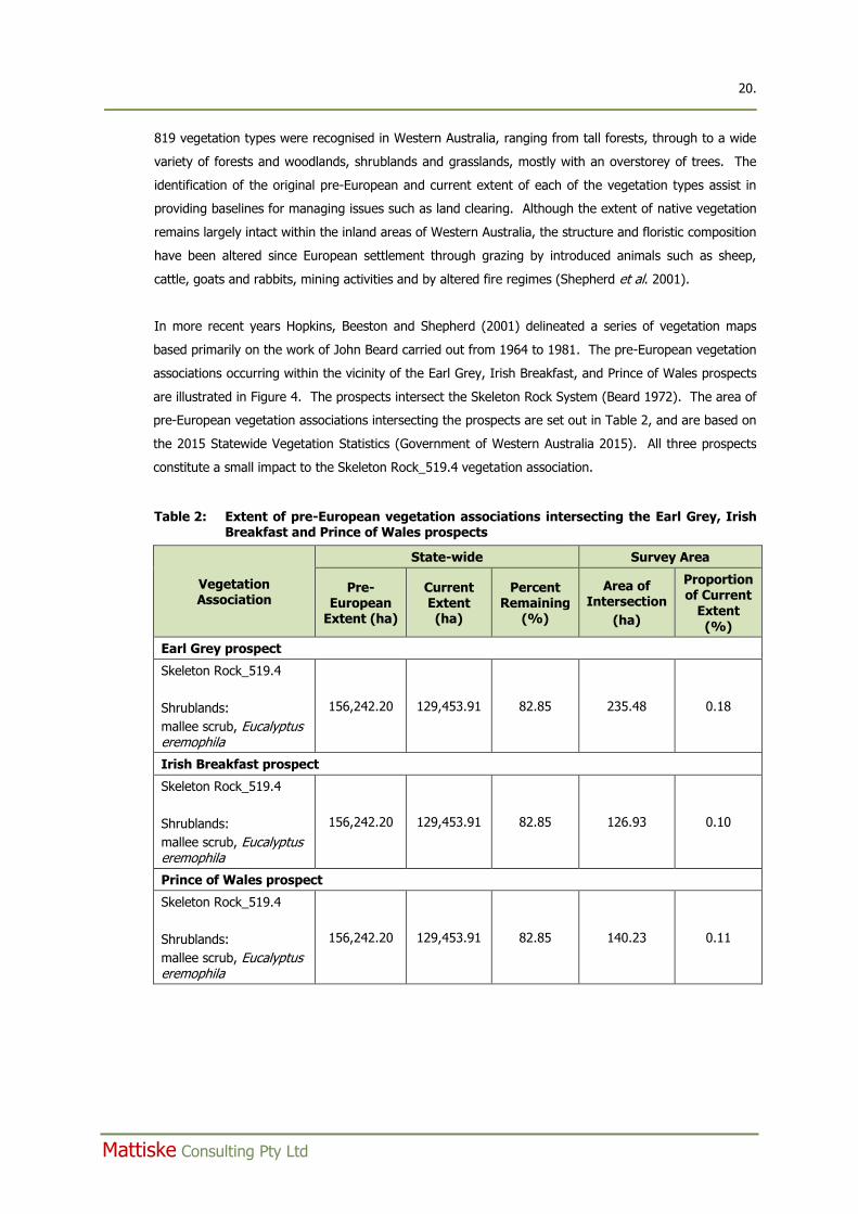
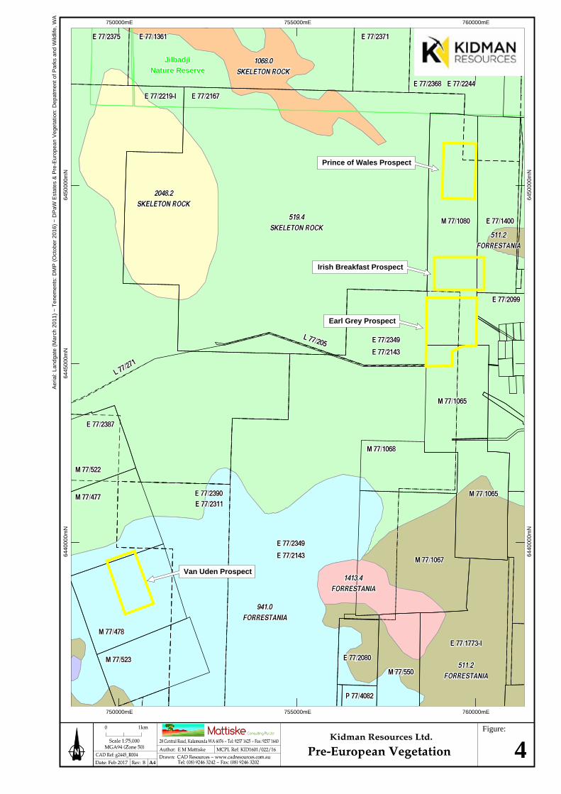
In more recent years Hopkins, Beeston and Shepherd (2001) delineated a series of vegetation maps
based primarily on the work of John Beard carried out from 1964 to 1981. The pre-European vegetation
associations occurring within the vicinity of the Earl Grey, Irish Breakfast, and Prince of Wales prospects
are illustrated in Figure 4. The prospects intersect the Skeleton Rock System (Beard 1972). The area of
pre-European vegetation associations intersecting the prospects are set out in Table 2, and are based on
the 2015 Statewide Vegetation Statistics (Government of Western Australia 2015). All three prospects
constitute a small impact to the Skeleton Rock_519.4 vegetation association.
Table 2: Extent of pre-European vegetation associations intersecting the Earl Grey, Irish Breakfast and Prince of Wales prospects
Vegetation Association
State-wide Survey Area
Pre-European
Extent (ha)
Current Extent (ha)
Percent Remaining
(%)
Area of Intersection
(ha)
Proportion of Current
Extent (%)
Earl Grey prospect
Skeleton Rock_519.4
Shrublands:
mallee scrub, Eucalyptus eremophila
156,242.20 129,453.91 82.85 235.48 0.18
Irish Breakfast prospect
Skeleton Rock_519.4
Shrublands:
mallee scrub, Eucalyptus eremophila
156,242.20 129,453.91 82.85 126.93 0.10
Prince of Wales prospect
Skeleton Rock_519.4
Shrublands:
mallee scrub, Eucalyptus eremophila
156,242.20 129,453.91 82.85 140.23 0.11
750000mE 755000mE 760000mE
6440
000m
N64
4500
0mN
6450
000m
N
750000mE 755000mE 760000mE
6440
000m
N64
5000
0mN
Aer
ial:
Land
gate
(M
arch
201
1) ~
Ten
emen
ts: D
MP
(O
ctob
er 2
016)
~ D
PaW
Est
ates
& P
re-E
urop
ean
Veg
etat
ion:
Dep
atm
ent o
f Par
ks a
nd W
ildlif
e, W
A
Van Uden Prospect
Irish Breakfast Prospect
Prince of Wales Prospect
Earl Grey Prospect
JilbadjiJilbadjiNature ReserveNature Reserve
Figure:
4
22. ____________________________________________________________________________________________
Mattiske Consulting Pty Ltd
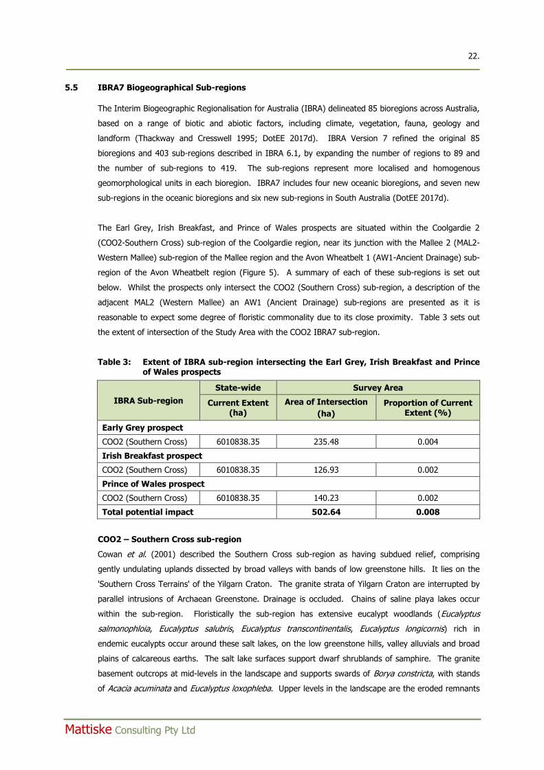
5.5 IBRA7 Biogeographical Sub-regions
The Interim Biogeographic Regionalisation for Australia (IBRA) delineated 85 bioregions across Australia,
based on a range of biotic and abiotic factors, including climate, vegetation, fauna, geology and
landform (Thackway and Cresswell 1995; DotEE 2017d). IBRA Version 7 refined the original 85
bioregions and 403 sub-regions described in IBRA 6.1, by expanding the number of regions to 89 and
the number of sub-regions to 419. The sub-regions represent more localised and homogenous
geomorphological units in each bioregion. IBRA7 includes four new oceanic bioregions, and seven new
sub-regions in the oceanic bioregions and six new sub-regions in South Australia (DotEE 2017d).
The Earl Grey, Irish Breakfast, and Prince of Wales prospects are situated within the Coolgardie 2
(COO2-Southern Cross) sub-region of the Coolgardie region, near its junction with the Mallee 2 (MAL2-
Western Mallee) sub-region of the Mallee region and the Avon Wheatbelt 1 (AW1-Ancient Drainage) sub-
region of the Avon Wheatbelt region (Figure 5). A summary of each of these sub-regions is set out
below. Whilst the prospects only intersect the COO2 (Southern Cross) sub-region, a description of the
adjacent MAL2 (Western Mallee) an AW1 (Ancient Drainage) sub-regions are presented as it is
reasonable to expect some degree of floristic commonality due to its close proximity. Table 3 sets out
the extent of intersection of the Study Area with the COO2 IBRA7 sub-region.
Table 3: Extent of IBRA sub-region intersecting the Earl Grey, Irish Breakfast and Prince of Wales prospects
IBRA Sub-region
State-wide Survey Area
Current Extent (ha)
Area of Intersection
(ha)
Proportion of Current Extent (%)
Early Grey prospect
COO2 (Southern Cross) 6010838.35 235.48 0.004
Irish Breakfast prospect
COO2 (Southern Cross) 6010838.35 126.93 0.002
Prince of Wales prospect
COO2 (Southern Cross) 6010838.35 140.23 0.002
Total potential impact 502.64 0.008
COO2 – Southern Cross sub-region
Cowan et al. (2001) described the Southern Cross sub-region as having subdued relief, comprising
gently undulating uplands dissected by broad valleys with bands of low greenstone hills. It lies on the
'Southern Cross Terrains' of the Yilgarn Craton. The granite strata of Yilgarn Craton are interrupted by
parallel intrusions of Archaean Greenstone. Drainage is occluded. Chains of saline playa lakes occur
within the sub-region. Floristically the sub-region has extensive eucalypt woodlands (Eucalyptus
salmonophloia, Eucalyptus salubris, Eucalyptus transcontinentalis, Eucalyptus longicornis) rich in
endemic eucalypts occur around these salt lakes, on the low greenstone hills, valley alluvials and broad
plains of calcareous earths. The salt lake surfaces support dwarf shrublands of samphire. The granite
basement outcrops at mid-levels in the landscape and supports swards of Borya constricta, with stands
of Acacia acuminata and Eucalyptus loxophleba. Upper levels in the landscape are the eroded remnants
23. ____________________________________________________________________________________________
Mattiske Consulting Pty Ltd
of a lateritic duricrust yielding yellow sandplains, gravelly sandplains and laterite breakaways. Mallees
(Eucalyptus leptopoda, Eucalyptus platycorys and Eucalyptus scyphocalyx) and scrub-heaths
(Allocasuarina corniculata, Callitris preissii, Melaleuca uncinata and Acacia beauverdiana) occur on these
uplands, as well as on sand lunettes associated with playas along the broad valley floors, and sand
sheets around the granite outcrops. The scrubs are rich in endemic acacias and Myrtaceae. The
dominant land uses are grazing and dry land agriculture.
MAL2 – Western Mallee sub-region
Beecham and Danks (2001) described the Western mallee sub-region as gently undulating, with partially
occluded drainage. Mallee over myrtaceous-proteaceous heaths on duplex (sand over clay) soils are
common. Melaleuca shrublands characterise alluvia, and Halosarcia low shrublands occur on saline
alluvium. A mosaic of mixed eucalypt woodlands and mallee occur on calcareous earth plains and
sandplains overlying Eocene limestone strata in the east. The landscape is fragmented with particular
surface-types almost completely cleared as wheatfields. The dominant land use is dry land agriculture.
AW1 – Ancient Drainage sub-region
Beecham (2001) described the Ancient Drainage sub-region as an area of active drainage dissecting a
Tertiary plateau on the Yilgarn Craton. It has a gently undulating landscape of low relief. Proteaceous
scrub-heaths, rich in endemics, on residual lateritic uplands and derived sandplains; mixed eucalypt,
Allocasuarina huegeliana and Jam-York Gum woodlands on Quaternary alluvials and colluvials. Within
this bioregion, the AW1 is an ancient peneplain with low relief, gently undulating landscape. There is no
connected drainage; salt lake chains occur as remnants of ancient drainage systems that now only
function in very wet years. Lateritic uplands are dominated by yellow sandplain. The dominant land
uses are dry land agriculture, grazing, mining and rural residential.
5.6 Previous Flora and Vegetation Surveys in the Vicinity of the Earl Grey, Irish Breakfast, and Prince of Wales Prospects
Several reports related to flora and vegetation surveys in the vicinity of the Earl Grey, Irish Breakfast,
and Prince of Wales prospects were reviewed to provide localised contextual flora information. These
results of these reports are summarised below.
Craig, G.F. (2006). Bounty JV - Tenements M77/1080, M77/1065, M77/1066, M77/1067, M77/1068 -
Declared Rare and Priority Survey. Unpublished report prepared for Nickel Australia Limited.
In 2006, Craig (2006) completed a threatened and priority flora survey for Nickel Australia Limited along
a series of 30 drill lines at its Bounty mine site. Some of the drill lines surveyed were within Kidman’s
Earl Grey and Prince of Wales prospects. No threatened flora pursuant to Schedule 1 of the Wildlife
Conservation Act 1950 and as listed by the DPaW (2017b) were recorded along any of the drill lines
searched. Three taxa which were priority flora (DPaW 2017g) at the time of the survey were recorded.
These were: Baeckea sp. Forrestania (KR Newbey 1105) (P1) – a minimum of 160 plants recorded at 11
COO2Southern Cross
MAL2Western Mallee
COO2Southern Cross
AW1Avon Wheatbelt P1
Inte
rim B
ioge
ogra
phic
Reg
iona
lisat
ion
for A
ustra
lia (I
BRA)
, Ver
sion
7: A
ustra
lian
Gov
ernm
ent D
epar
tmen
t of t
he E
nviro
nmen
t ~ D
PaW
Est
ates
: Dep
atm
ent o
f Par
ks a
nd W
ildlif
e, W
A
700000mE 750000mE
6550
000m
N65
0000
0mN
6450
000m
N64
0000
0mN
700000mE 750000mE
6550
000m
N65
0000
0mN
6450
000m
N64
0000
0mN
Earl Grey Prospect
Van Uden Prospect
Prince of Wales Prospect
Irish Breakfast Prospect
Figure:
5
25. ____________________________________________________________________________________________
Mattiske Consulting Pty Ltd
separate locations; Daviesia newbeyi (P3) – a single plant recorded at one location; and Stenanthemum
aff. poicilum (P3) – a minimum of 110 plants recorded at 13 separate locations.
At the time of the 2006 survey, Daviesia newbeyi was listed as a Priority 2 taxon and Stenanthemum
poicilum was listed as a Priority 2 taxon. Stenanthemum poicilum (P3) does not occur in the Forrestania
area. Its distribution is restricted to the northern portion of the Avon Wheatbelt region at its boundary
with the Yalgoo bioregion (DPaW 2017g). At the time of the 2006 survey (Craig 2006), a personal
communication with Barbara Rye of the Western Australian Herbarium indicated that the specimens
collected during the survey for Nickel Australia Limited differed from the typical Stenanthemum poicilum
(P3), which grows in the Morawa – Mullewa district, some 600 km to the north-west. Due to its
similarity to Stenanthemum poicilum (P3), it was attributed as Stenanthemum aff. poicilum (P3).
Native Vegetation Solutions (2014). Level 1 Flora and Vegetation Survey of the Proposed Blue Vein Mine
Mt. Holland Operation (Tenement M77/1065). Unpublished report prepared for Convergent
Minerals Limited, September 2014.
Convergent Minerals Limited, as part of their proposal to recommence mining activities at their Blue Vein
Mine, 4.5 km south-south-west of the Earl Grey prospect, commissioned a Level 1 flora and vegetation
survey of approximately 90 ha at their Blue Vein Mine. The area surveyed included existing pit and
waste dump areas, as well as nearby bushland, some of which had been the subject of an intense fire in
April of 2014 (Native Vegetation Solutions 2014).
The survey resulted in a total of 71 vascular plant tax being recorded (Appendix C). The names of the
taxa recorded by Native Vegetation Solutions (2014) have been updated, where required, to make them
consistent with current day nomenclature (DPaW 2017g). No threatened flora pursuant to Schedule 1 of
the Wildlife Conservation Act 1950 and as listed by the DPaW (2017b) were recorded. No priority flora,
as listed by the DPaW (2017g), were recorded within the survey area. Two major vegetation
communities were defined within the survey area. One of these vegetation communities was a
Eucalyptus mallee woodland over Melaleuca shrubland. The dominant species in this community were
Eucalyptus urna, Eucalyptus loxophleba subsp. lissophloia, Eucalyptus platycorys, Melaleuca pauperiflora
subsp. pauperiflora, Melaleuca eleuterostachya, Melaleuca lateriflora, Melaleuca cucullata, Phebalium
filifolium, and Phebalium tuberculosum. The second major vegetation community defined was a
Eucalyptus woodland over Allocasuarina shrubland. The dominant species in this vegetation community
were Eucalyptus livida, Eucalyptus loxophleba subsp. lissophloia, Allocasuarina acutivalvis subsp.
acutivalvis, Allocasuarina campestris, Allocasuarina huegeliana, Hibbertia rostellata, Calothamnus
quadrifidus subsp. semilunaris, Rinzia sessilis, Thryptomene kochii and Persoonia helix. Native
Vegetation Solutions (2014) delineated both burnt and unburnt area of both vegetation communities
within the survey area.
Convergent Minerals Limited (2014). Threatened Flora Management Plan for Banksia sphaerocarpa var.
dolichostyla. Mt. Holland Gold Project Blue Vein Operations DRAFT V2.0., October 2014.
26. ____________________________________________________________________________________________
Mattiske Consulting Pty Ltd
Convergent Minerals Limited, as part of their proposal to recommence mining activities at their Blue Vein
Mine, 4.5 km south-south-west of the Earl Grey prospect, prepared a management plan to ensure
existing populations of Banksia sphaerocarpa var. dolichostyla (T) were not impacted from proposed
mining activities in the project area. Whilst no Banksia sphaerocarpa var. dolichostyla (T) were recorded
within the proposed development areas (Native Vegetation Solutions 2014), Banksia sphaerocarpa var.
dolichostyla (T) was recorded along existing roadside edges proposed to be utilised by light vehicles to
access the camp and a separate existing haul road proposed to be utilised by haulage trucks. The
objectives of the management plan (Convergent Minerals Limited 2014) were to prevent potential
adverse impacts on Banksia sphaerocarpa var. dolichostyla populations in, or adjacent to the Blue Vein
Mine Project and its associated operations, and to raise awareness about Banksia sphaerocarpa var.
dolichostyla. These objectives were to be met by documenting the distribution of the species in the
vicinity of the Blue Vein Mine Project; providing detailed species and preferred habitat description;
identifying threatening processes to the species arising from the implementation of mining operations;
developing strategies to reduce avoidable adverse impacts on the species; outline a monitoring program
that aims to detect a decline in the health of local Banksia sphaerocarpa var. dolichostyla populations
associated with the proposed mining activities; and allocate responsibilities for the implementation of the
management plan.
Native Vegetation Solutions (2016a). Level 1 Flora and Vegetation Survey of the Proposed Initial
Cheritons and Texas Exploration Drill Lines- Jilbadji Nature Reserve Mt Holland Operation
(Tenements E77/2111 & E77/2244). Unpublished draft report prepared for Kidman Resources
Limited, August 2016
Kidman commissioned Native Vegetation Solutions to undertake a Level 1 flora and vegetation survey of
their Cheritons (exploration tenement E77/2111) and Texas (exploration tenement E77/2244)
tenements, which form part of their Mt Holland project. Both tenements are situated within the Jilbadji
Nature Reserve, and as such the flora and vegetation survey was an integral part of the process to
develop a Conservation Management Plan. The Texas prospect is situated 800 m north of the Prince of
Wales prospect.
The survey resulted in a total of 151 species of vascular plants being recorded (Appendix C). The names
of the taxa recorded by Native Vegetation Solutions (2016a) have been updated, where required, to
make them consistent with current day nomenclature (DPaW 2017g). No threatened flora pursuant to
Schedule 1 of the Wildlife Conservation Act 1950 and as listed by the DPaW (2017b) were recorded.
Three priority flora, as listed by the DPaW (2017g), were recorded within the survey areas. The priority
flora recorded were Acacia undosa (P3), Grevillea lullfitzii (P1) and Microcorys sp. Forrestania (V. English
2004) (P4). No introduced species were recorded within the surveyed area. Native Vegetation Solutions
defined eight vegetation communities in the combined Cheritons/Texas project areas. These are
summarised below.
Eucalyptus mallee woodland over Melaleuca shrubland and emergent Callitris preissii
27. ____________________________________________________________________________________________
Mattiske Consulting Pty Ltd
The dominant species in this community were Eucalyptus eremophila subsp. eremophila, Eucalyptus
livida, Melaleuca pauperiflora subsp. pauperiflora, Melaleuca lateriflora, Melaleuca hamata, Phebalium
tuberculosum and Cryptandra nutans. This community occupied an area of 1.29 ha (11.93%) of the
total area surveyed (10.81 ha).
Eucalyptus mallee woodland (burnt)
The dominant species in this community were Eucalyptus eremophila subsp. eremophila, Eucalyptus
livida, Eucalyptus polita, Acacia fragilis, Gastrolobium spinosum, Melaleuca lateriflora, Thryptomene
kochii, Grevillea acuaria, Dodonaea stenozyga and Hakea scoparia subsp. scoparia. This community
occupied an area of 2.76 ha (25.53%) of the total area surveyed (10.81 ha).
Eucalyptus woodland over Allocasuarina shrubland
The dominant species in this community were Eucalyptus livida, Eucalyptus polita, Allocasuarina
campestris, Hakea scoparia subsp. scoparia, Cryptandra nutans, Acacia sphacelata subsp. sphacelata,
Calothamnus quadrifidus subsp. seminudus and Beyeria sulcata var. brevipes. This community occupied
an area of 0.07 ha (0.65%) of the total area surveyed (10.81 ha).
Sandplain mallee heath shrubland (burnt)
The dominant species in this community were Persoonia helix, Persoonia coriacea, Melaleuca hamata,
Hakea multilineata, Cyathostemon heterantherus, Hibbertia eatoniae, Melaleuca cordata, Gastrolobium
spinosum, Bertya dimerostigma, Lepidosperma sanguinolentum and Gompholobium gompholobioides.
This community occupied an area of 4.48 ha (41.44%) of the total area surveyed (10.81 ha).
Eucalyptus salmonophloia woodland
The dominant species in this community were Eucalyptus salmonophloia, Alyxia buxifolia, Scaevola
spinescens, Acacia colletioides, Acacia hemiteles, Westringia cephalantha var. cephalantha and Acacia
acuminata. This community occupied an area of 0.17 ha (1.57%) of total area surveyed (10.81 ha).
Eucalyptus salmonophloia woodland (burnt)
The dominant species in this community were Eucalyptus salmonophloia, Alyxia buxifolia, Scaevola
spinescens, Acacia colletioides, Acacia hemiteles, Westringia cephalantha var. cephalantha and Acacia
acuminata. This community occupied an area of 0.47 ha (4.35%) of total area surveyed (10.81 ha).
Eucalyptus urna woodland over Melaleuca shrubland
The dominant species in this community were Eucalyptus urna, Eucalyptus salubris, Eucalyptus
eremophila subsp. eremophila, Olearia muelleri, Melaleuca lateriflora, Phebalium tuberculosum and
Melaleuca pauperiflora subsp. pauperiflora. This community occupied an area of 0.05 ha (0.46%) of
total area surveyed (10.81 ha).
Eucalyptus mallee woodland over Acacia steedmanii
The dominant species in this community were Eucalyptus livida, Eucalyptus loxophleba subsp.
lissophloia, Phebalium filifolium, Acacia hemiteles, Allocasuarina helmsii, Grevillea stenobotrya, Grevillea
28. ____________________________________________________________________________________________
Mattiske Consulting Pty Ltd
pterosperma, Melaleuca cordata, Leucopogon sp. outer wheatbelt (M. Hislop 30), Acacia neurophylla
subsp. erugata and Acacia steedmanii subsp. steedmanii. This community occupied an area of 1.52 ha
(14.06%) of total area surveyed (10.81 ha).
Native Vegetation Solutions (2016b). Threatened flora targeted survey for Kidman Resources Ltd – Mt
Holland Gold project, Earl Grey Prospect. Unpublished memorandum prepared for Kidman
Resources Limited, 16th September 2016.
In September 2016, Native Vegetation Solutions was commissioned to undertake a targeted search to
assess potential threatened flora within the Earl Grey prospect at the Mt Holland Project (Native
Vegetation Solutions 2016b). The result of the search was that no threatened flora pursuant to
Schedule 1 of the Wildlife Conservation Act 1950 and as listed by the DPaW (2017b) were recorded in
the Earl Grey prospect. The majority of vegetation within the survey area comprised mallee woodland
over Melaleuca shrubland, which was deemed not to be suitable habitat for Banksia sphaerocarpa var.
dolichostyla, which is known to exist in the area about the Mt Holland Project area.
5.7 Survey of the Eastern Goldfields in the Vicinity of the Earl Grey, Irish Breakfast, and Prince of Wales Prospects
Newbey and Hnatiuk (1988), as part of a series of biological surveys of the Eastern Goldfields described,
in broad terms, the landforms and vegetation of the area in which the Earl Grey, Irish Breakfast, and
Prince of Wales prospects are situated. Newbey (1988) classed the landform of the area in which the
Earl Grey, Irish Breakfast, and Prince of Wales prospects are situated as comprising sandplain, made up
of the following component landform elements (Newbey and Hnatiuk 1988):
Plains of shallow sandy clays supporting Eucalyptus salmonophloia woodlands, Eucalyptus
celastroides subsp. virella mallee and Eucalyptus salubris low woodlands;
Plains of shallow sand supporting Eucalyptus redunca mallee; Eucalyptus transcontinentalis mallee
and Melaleuca spp. tall shrubland;
Thick soil sheets on plain in deep sands supporting Eucalyptus aff. decipiens mallee, Eucalyptus aff.
occidentalis mallee, Eucalyptus tetragona mallee, Eucalyptus eremophila mallee, Acacia
beauverdiana tall shrubland, and Grevillea eriostachya subsp. eriostachya tall shrubland;
Slight rises comprising gravelly sands supporting Acacia signata tall shrubland, Allocasuarina
acutivalvis tall shrubland, Allocasuarina campestris tall shrubland, Callitris preissii subsp. verrucosa
tall shrubland;
Plains of gravelly sands supporting Hakea cf. falcata low shrubland; and
Small depressions of alluvium supporting Eucalyptus georgei low woodlands.
5.8 Survey Associated with the Banded Ironstone Hill Formations in the Vicinity of the Earl Grey, Irish Breakfast, and Prince of Wales Prospects
The flora and vegetation of the Middle and South Ironcap, Digger Rock and Hatter Hill was surveyed and
the results reported by Gibson (2004a), as part of a series of detailed floristic studies of the ranges of
the Eastern Goldfields. The Earl Grey, Irish Breakfast, and Prince of Wales prospects are situated in the
29. ____________________________________________________________________________________________
Mattiske Consulting Pty Ltd
vicinity of the Forrestania greenstone belt, which extends from Mt Holland south to Hatter Hill, a
distance of some 70 km. The study area was located 80 km east-south-east of Hyden, between Middle
Ironcap and Hatter Hill. Gibson (2004a) established 38 quadrats along the range system and data from
these quadrats was used to define four floristic community types.
Gibson (2004a) recorded a total of 343 vascular plant taxa across the 38 survey quadrats established
(Appendix C). The names of the taxa recorded by Gibson (2004a) have been updated, where required,
to make them consistent with contemporary nomenclature (DPaW 2017g). Thirty-five of the taxa
recorded at the time of the survey were of conservation significance. These included:
three taxa listed as threatened;
a further 29 that are being considered for listing as threatened flora;
10 taxa considered endemic to the range; and
a further eight that are regional endemics (found within 100 km).
The multivariate statistical analysis of the data resulted in the division of the 38 survey quadrats into
four community types. Community types 1 and 2 occurred on skeletal soils derived from banded
ironstone and the massive laterites. Community types 3 and 4 occurred on deeper soils derived from
greenstone or decomposing laterites. A summary of each of the four community types is set out below.
Community Type 1
Community type 1 is comprised of the species-rich shrublands or mallee shrublands. Average species
richness was 27.2 taxa/quadrat. This community type was restricted to the massive outcrops along the
range (Middle Ironcap, South Ironcap, Digger Rock and Hatter Hill). Three subtypes were recognized.
Type 1a occurred on all outcrops. Type 1b was restricted to area around South Ironcap. Type 1c
generally lacked taxa in species was found at Middle Ironcap and the Hatter Hill area. Indicator species
for this community type were Lepidosperma sp (NG & KB 2509), Beaufortia schaueri, Gastrolobium
spinosum, Dryandra pallida, Melaleuca pungens, Petrophile glauca, Hakea multilineata, Goodenia
pinifolia, Persoonia helix, Isopogon gardneri, Leptospermum fastigiatum, Dryandra viscida, Allocasuarina
campestris, Melaleuca cordata, Astroloma serratifolium, Hakea subsulcata, Comesperma volubile,
Calytrix breviseta subsp. stipulosa, Verticordia chrysantha, Drummondita hassellii, Stylidium
breviscapum, Micromyrtus racemosa, Phebalium ambiguum and Psammomoya choretroides.
Community Type 2
Community type 2 were generally mallee shrublands or Allocasuarina thickets primarily found on massive
laterites. Species richness tended to be lower than in community type 1 (20.3 taxa/quadrat).
Distribution of this community was again closely correlated with the massive outcrops at Middle Ironcap,
Digger Rock and Hatter Hill. It was not recorded from South Ironcap. Indicator species for this
community type were Acrotriche patula, Callitris canescens, Eriochilus dilatatus, Austrodanthonia
caespitosa, Caladenia paradoxa, Platysace maxwellii, Melaleuca uncinata, Dodonaea bursariifolia,
Santalum acuminatum and Olearia muelleri.
30. ____________________________________________________________________________________________
Mattiske Consulting Pty Ltd
Community Type 3
Community type 3 were eucalypt woodlands dominated or co-dominated by Eucalyptus urna and
Eucalyptus salubris occurring on the colluvial deposits on the flats below the outcrops or on the broad
flat ridges along the range generally with an understorey dominated by Melaleuca spp. Species richness
was considerably lower (14.4 taxa/quadrat). Only one local endemic (Melaleuca agathosmoides) is
found in this community group - all the other local and regional endemics are restricted to community
types 1 and 2. Indicator species for this community type were Eucalyptus calycogona subsp.
calycogona, Eucalyptus salmonophloia, Melaleuca teuthidoides, Microtis media subsp. media, Pultenaea
arida, Dodonaea stenozyga, Eucalyptus annulata, Eucalyptus salubris, Melaleuca cucullata, Eucalyptus
urna, Exocarpos aphyllus, Melaleuca pauperiflora subsp. pauperiflora and Microcybe albiflora.
Community Type 4
Community type 4 was a species poor mallee community generally dominated by Eucalyptus calycogona
with large emergent Eucalyptus salmonophloia on small colluvial flats in the ranges. Species richness
was low with an average 12.5 taxa/quadrat. Indicator species for this community type were Eucalyptus
calycogona, Eucalyptus salmonophloia and Olearia muelleri.
In biogeographical terms the range was most similar to the Bremer Range (Gibson and Lyons 1998a)
and Parker Ranges (Gibson & Lyons 1998b), with a high diversity of eucalypts, acacias and melaleucas,
and low richness of Eremophila spp. compared to the more northern ranges (Highclere Hills, Jaudi
uplands, Helena and Aurora Range, Mt Manning Range) (Gibson and Lyons 2001a, Gibson and Lyons
2001b, Gibson et. al. 1997, Gibson 2004b). Despite considerable mining and exploration activity in the
area, the flora and vegetation remain poorly known.
5.9 Threatened Ecological Communities
No TECs listed by the DPaW (2017e) occur within the vicinity of the Earl Grey, Irish Breakfast, and
Prince of Wales prospects. No TECs, pursuant to the EPBC Act and as listed by the DotEE (2017b) occur
within the vicinity of the Earl Grey, Irish Breakfast, and Prince of Wales prospects.
5.10 Priority Ecological Communities
One PEC, as listed by DPaW (2017f) currently intersects the Earl Grey, Irish Breakfast, and Prince of
Wales prospects. The entire areas of the three prospects are situated within the Ironcap Hills
Vegetation Complexes (Mt. Holland, Middle, North and South Ironcap Hills, Digger Rock and Hatter Hill)
(banded ironstone), a Priority 3 ecological community (Figure 6). The principle threat to this PEC is
mining (DPaW 2017f).
5.11 Nature Reserves
The Prince of Wales, Irish Breakfast and Earl Grey prospects are situated situated 800 m, 4km and
5.2km south of the Jilbadji Nature Reserve, respectively (Figure 6). The Jilbadji Nature Reserve
(Reserve C 24049) comprises an area of 208,860 ha, situated along the Forrestania Southern Cross
31. ____________________________________________________________________________________________
Mattiske Consulting Pty Ltd
Road, west of Barker Lake, 20 km east-south-east of Marvel Loch. The Jilbadji Nature reserve is on the
Register of the National Estate and was registered in 1978 (DotEE 2017e).
Given the extent of clearing in the Wheatbelt for dryland agriculture, the Jilbadji Nature Reserve is a
significant area in maintaining existing ecological processes at a regional scale. With an area of 208,860
ha, it is a potentially important refugium for many species, including invertebrates and smaller
vertebrates. The Jilbadji Nature Reserve is in the north-eastern part of the Wheatbelt region that is rich
in endemic species at a national scale (DotEE 2017e).
5.12 Flora
A total of 720 plant taxa were identified in the desktop assessment as having the potential to occur
within the Earl Grey, Irish breakfast, Prince of Wales and Van Uden prospects (Appendix C). These 720
taxa are representative of 62 families and 205 genera. The most commonly represented families were
the Myrtaceae (158 taxa), Fabaceae (119 taxa), Proteaceae (69 taxa), Orchidaceae (32 taxa) and
Asteraceae (30 taxa). The most commonly represented genera were Acacia and Eucalyptus (both 65
taxa), Melaleuca (39 taxa), and Grevillea (25 taxa).
5.13 Threatened and Priority Flora
A total of four known threatened flora taxa, 56 known priority flora taxa and one taxon which is
currently presumed to be extinct have the potential to occur within the survey area. The 56 priority
flora taxa were comprised of fifteen Priority 1, seven Priority 2, twenty-four Priority 3 and ten Priority 4
taxa (DPaW 2017g). These priority flora taxa are listed in Table 4. The distribution of known
threatened and priority flora taxa, based on the DPaW’s Threatened (Declared Rare) and Priority Flora
database and the Western Australian Herbarium Specimen database in the vicinity of the Earl Grey, Irish
Breakfast, Prince of Wales and Van Uden prospects is illustrated in Figure 6.
An assessment of the likelihood of recording any of the listed threatened and priority taxa within the Earl
Grey, Irish Breakfast, and Prince of Wales prospects, based on factors including known soil type,
topography and distribution, is set out in Appendix D. Based on this assessment, one taxon – Acacia
undosa (P3) – was ranked as being highly likely to be recorded as it is known to occur within the vicinity
of the Earl Grey, Irish Breakfast, and Prince of Wales prospects. Twenty-two taxa were ranked with a
medium likelihood of being recorded in the survey area, of which three are considered threatened taxa
(Table 4). The remaining 37 taxa were ranked with a low likelihood of being recorded in the survey
area, and a single taxon presumed to be extinct was ranked as unlikely (Table 4).
32. ____________________________________________________________________________________________
Mattiske Consulting Pty Ltd
Table 4: Priority flora taxa in the vicinity of the Earl Grey, Irish Breakfast and Prince of Wales prospects
Species SCC1 FCC2 Family Likelihood to
Record
Acacia undosa P3 - Fabaceae high
Acacia lanuginophylla T E Fabaceae medium
Banksia sphaerocarpa var. dolichostyla T V Proteaceae medium
Eucalyptus steedmanii T V Myrtaceae medium
Baeckea sp. Blue Haze Mine (P. Armstrong 06/910)
P1 - Myrtaceae medium
Baeckea sp. North Ironcap (R.J. Cranfield
10580) P1 - Myrtaceae
medium
Dicrastylis capitellata P1 - Lamiaceae medium
Hemigenia sp. Newdegate (E. Bishop 75) P1 - Lamiaceae medium
Acacia asepala P2 - Fabaceae medium
Eutaxia lasiocalyx P2 - Fabaceae medium
Acacia singula P3 - Fabaceae medium
Baeckea sp. Merredin (K.R. Newbey 2506)
P3 - Myrtaceae medium
Eutaxia acanthoclada P3 - Fabaceae medium
Leucopogon sp. Ironcaps (N. Gibson & K. Brown 3070)
P3 - Ericaceae medium
Persoonia cymbifolia P3 - Proteaceae medium
Phebalium brachycalyx P3 - Rutaceae medium
Pultenaea daena P3 - Fabaceae medium
Seringia adenogyna P3 - Malvaceae medium
Stylidium sejunctum P3 - Stylidiaceae medium
Verticordia gracilis P3 - Myrtaceae medium
Verticordia stenopetala P3 - Myrtaceae medium
Microcorys sp. Forrestania (V. English 2004)
P4 - Lamiaceae medium
Stenanthemum bremerense P4 - Rhamnaceae medium
Boronia revoluta T E Rutaceae low
Austrostipa sp. Carlingup Road (S. Kern & R. Jasper LCH 18459)
P1 - Poaceae low
Brachyloma stenolobum P1 - Ericaceae low
Eucalyptus myriadena subsp. parviflora P1 - Myrtaceae low
Gastrolobium tenue P1 - Fabaceae low
Grevillea lissopleura P1 - Proteaceae low
Grevillea lullfitzii P1 - Proteaceae low
Grevillea marriottii P1 - Proteaceae low
Hibbertia axillibarba P1 - Dilleniaceae low
Labichea rossii P1 - Fabaceae low
Lepidosperma amantiferrum P1 - Cyperaceae low
Stenanthemum liberum P1 - Rhamnaceae low
Acacia heterochroa subsp. robertii P2 - Fabaceae low
33. ____________________________________________________________________________________________
Mattiske Consulting Pty Ltd
Table 4 (ctd): Priority flora taxa in the vicinity of the Earl Grey, Irish Breakfast and Prince of Wales prospects
Species SCC1 FCC2 Family Likelihood to
Record
Bentleya diminuta P2 - Pittosporaceae low
Conospermum sigmoideum P2 - Proteaceae low
Dampiera orchardii P2 - Goodeniaceae low
Orianthera exilis P2 - Loganiaceae low
Angianthus micropodioides P3 - Asteraceae low
Baeckea sp. Parker Range (M. Hislop & F. Hort MH 2968)
P3 - Myrtaceae low
Banksia viscida P3 - Myrtaceae low
Chorizema circinale P3 - Fabaceae low
Daviesia newbeyi P3 - Fabaceae low
Eucalyptus exigua P3 - Myrtaceae low
Grevillea insignis subsp. elliotii P3 - Proteaceae low
Grevillea pilosa subsp. redacta P3 - Proteaceae low
Hakea pendens P3 - Proteaceae low
Melaleuca ochroma P3 - Myrtaceae low
Mirbelia densiflora P3 - Fabaceae low
Oxymyrrhine plicata P3 - Myrtaceae low
Calamphoreus inflatus P4 - Scrophulariaceae low
Eremophila biserrata P4 - Scrophulariaceae low
Eremophila racemosa P4 - Scrophulariaceae low
Eucalyptus georgei subsp. fulgida P4 - Myrtaceae low
Eucalyptus rugulata P4 - Myrtaceae low
Grevillea neodissecta P4 - Proteaceae low
Gyrostemon ditrigynus P4 - Gyrostemonaceae low
Myriophyllum petraeum P4 - Haloragaceae low
Thomasia gardneri X Ex Malvaceae unlikely
1 - State Conservation Code (refer Appendix A). 2 – Federal Conservation Code (refer Appendix A).
Aeria
l: La
ndga
te (M
arch
201
1) ~
DPa
W E
stat
es: D
epat
men
t of P
arks
and
Wild
life,
WA
~ Pr
iorit
y Fl
ora:
Dep
atm
ent o
f Par
ks a
nd W
ildlif
e, W
A (R
ef 5
5-10
16FL
& 0
4-01
116E
C)
750000mE 755000mE 760000mE
6435
000m
N64
4000
0mN
6445
000m
N64
5000
0mN
6455
000m
N
750000mE 755000mE 760000mE
6435
000m
N64
4000
0mN
6445
000m
N64
5000
0mN
6455
000m
N
Van Uden Prospect
Irish Breakfast Prospect
Prince of Wales Prospect
Earl Grey Prospect
JilbadjiNature Reserve
Figure:
6
Priority
1234
HerbariumTHREATENED AND PRIORITY SPECIES
T / XTPFL
Priority Ecological Community
35. ____________________________________________________________________________________________
Mattiske Consulting Pty Ltd
5.14 Introduced (Exotic) Plant Species
A total of seven introduced (exotic) plant species were recorded from the desktop assessment utilising a
20 km search buffer about the Earl Grey, Irish breakfast, and Prince of Wales prospects (Table 5). None
of the species are listed as Declared Pest species pursuant to Section 22 of the Biosecurity and
Agriculture Management Act 2007. None of the species are listed as a Prohibited Organism pursuant to
Section 12 of the Biosecurity and Agriculture Management Act 2007 or listed as a Weed of National
Significance (DotEE 2017f).
Table 5: Introduced plant species in the vicinity of the Earl Grey, Irish Breakfast, and
Prince of Wales prospects
Introduced Species Common Name Family Potential
/Recorded4
*Carrichtera annua2, 3 Ward’s Weed Brassicaceae P
*Hypochaeris glabra1, 3 Smooth Cats-ear Asteraceae P
*Mesembryanthemum nodiflorum1, 3 Slender Iceplant Aizoaceae P
*Pentameris airoides subsp. airoides1, 3 - Poaceae P
*Rostraria pumila1, 3 Roughtail Poaceae P
*Ursinia anthemoides1, 3 South African marigold Asteraceae P
*Vulpia myuros forma megalura1, 3 Rats Tail Fescue Poaceae P
*Vulpia myuros forma myuros1, 3
1 - recorded from NatureMap (DPaW 2007-); 2 - recorded from DotEE (2017d); 3 – Permitted (s11) under the BAM Act 2007; 4 - P = Potential to occur.
5.15 Other Matters
In addition to the items reviewed in the preceding paragraphs of this desktop assessment (paragraphs
5.1 through 5.14), the EPBC Act Protected Matters Report (DotEE 2017c) reveals that within 20 km of
the Earl Grey, Irish breakfast, and Prince of Wales, the following applies:
World Heritage Properties none
National Heritage Places none
Wetlands of International Importance none
Listed Threatened Ecological Communities none
Commonwealth Heritage Places none
Critical Habitats none
Commonwealth Terrestrial Reserves none
Regional Forest Agreements none
Nationally Important Wetlands none
36. ____________________________________________________________________________________________
Mattiske Consulting Pty Ltd
6. FIELD SURVEY RESULTS
A total of 43 survey quadrats were used to assess the flora and vegetation of the Earl Grey (26
quadrats), Irish Breakfast (nine quadrats), and Prince of Wales (eight quadrats) prospects. Refer to
Appendix B for a list of the geographic locations for each of the survey quadrats.
6.1 Field Survey Limitations and Constraints
An assessment of the survey against a range of factors which may have had an impact on the outcomes
of the present survey was made (Table 6). Based on this assessment, the survey of the Earl Grey, Irish
Breakfast, and Prince of Wales prospects has not been subject to constraints which would affect the
thoroughness of the survey and the conclusions which have been formed.
Table 6: Potential flora and vegetation survey limitations for the Earl Grey, Irish Breakfast, and Prince of Wales prospects
Potential Survey Limitation Impact on Survey
Sources of information and availability of contextual information (i.e. pre-existing background versus new material).
Not a constraint. Reference resources such as Beard’s mapping, historical survey data in both the vicinity of the survey area (Consultant’s reports) and in the broader region (Gibson’s series of Flora and Vegetation surveys of the Eastern Goldfield Ranges / Newbey & Hnatiuk’s Biological Surveys of the Eastern Goldfields), together with online flora and vegetation information, has provided an appropriate level of information for the current survey.
Scope (i.e. what life forms, etc., were sampled).
Not a constraint. Vascular flora, which was the focus of the present survey of the Earl Grey, Irish Breakfast and Prince of Wales prospects, was thoroughly sampled.
Proportion of flora collected and identified (based on sampling, timing and intensity).
Not a constraint. The survey was undertaken over two consecutive months on the Earl Grey, Irish Breakfast and Prince of Wales prospects. Additionally, a search to determine if any conservation significant flora were present was undertaken concurrently. Based on the survey quadrat data, it was estimated that approximately 79.35% of the potential flora species that may occur were recorded. This value is based on the combined data for the Earl Grey, Irish Breakfast, Prince of Wales and Van Uden prospects. The use of data from all four prospects is justified on the basis that they were all situated in proximity to each other.
Completeness and further work which might be needed (i.e. was the relevant survey area fully surveyed).
Potential constraint. The survey of the Earl Grey, Irish Breakfast and Prince of Wales prospects was undertaken over two consecutive months and therefore there were potential constraints in relation to the aspect of multiple seasons of a “detailed” survey as defined in the EPA Technical Guide (2016b). Given that the survey area is situated within a PEC and that conservation significant flora were recorded either within the Earl Grey, Irish Breakfast and Prince of Wales prospects or the adjacent prospects and areas, a more detailed survey, together with a targeted search for conservation significant flora is recommended.
Mapping reliability. Potential constraint. The spatial coverage of the survey area is considered to be adequate. The aerial photographic maps available for the survey were of moderate resolution. Higher resolution aerials are likely to be available in the first quarter of 2017. As part of future planned survey work, vegetation communities will be validated using the high resolution aerial imagery, however it is unlikely that the areas will change significantly.
Vegetation community boundaries were often discontinuous with interfaces resembling admixtures of one or more communities. This is a recognised and unavoidable limitation of vegetation mapping, particularly across mosaic Eucalyptus / Melaleuca and other shrubs associations and open woodland associations.
37. ____________________________________________________________________________________________
Mattiske Consulting Pty Ltd
Potential Survey Limitation Impact on Survey
Timing, weather, season, cycle. Not a constraint. The EPA (2016a) recommends that flora and vegetation surveys in the Coolgardie region should be undertaken after the main rainfall period in the winter months. Rainfall in the four months preceding the October and November 2016 surveys was slightly below average (Figure 3), with the area experiencing approximately 90% of the long term average rainfall.
From a seasonal perspective, the majority of all flora present were either in flower or were towards the end of their flowering period. Consequently it was possible to collect excellent specimens (fertile and many with fruit) of the majority of flora for identification purposes. This was especially important given the diversity of flora and the high potential for conservation significant species to be present.
Disturbances (fire, flood, accidental human intervention, etc.).
Not a constraint. The Earl Grey, Irish Breakfast and Prince of Wales prospects exhibits moderate to high levels of disturbance form past mining activities. Old mine pits and waste deposits are present, together with old roads and exploration tracks. In addition, part of the Prince of Wales prospect was subject to a fire in February 2015 (Carla Vincent, Kidman, pers. comm.). The aerial photographic maps used for the present survey show the pre-fire vegetation, thus increasing the degree of error associated with delineating accurate vegetation community boundaries.
Intensity (in retrospect, was the intensity adequate).
Not a constraint. The intensity of the survey effort of the Earl Grey, Irish Breakfast and Prince of Wales prospects, given the level of survey, was considered to be good.
Resources (i.e. were there adequate resources to complete the survey to the required standard).
Not a constraint. Resources, in terms of equipment, support and personnel were good.
Access problems (i.e. ability to access survey area).
Not a constraint. Vehicle access to the Earl Grey, Irish Breakfast and Prince of Wales prospects area was via a range of tracks that traversed the length and width of the prospect. These provided excellent access to the entirety of the survey area.
Experience levels (e.g. degree of expertise in plant identification to taxon level).
Not a constraint. All botanists had extensive experience working in a range of botanical districts across the state, and all had all botanists had experience working in the Coolgardie/Goldfields region.
6.2 Flora
A total of 184 vascular plant taxa which are representative of 86 genera and 35 families were recorded
in the Earl Grey, Irish Breakfast and Prince of Wales prospects. The majority of taxa recorded were
representative of the Myrtaceae (46 taxa), Fabaceae (30 taxa), and Proteaceae (19 taxa) families. The
majority of families (23 of 35) were represented by three or less taxa. The taxa recorded during the
survey are set out in Appendix C. A list of plant taxa recorded at each survey quadrat within the Earl
Grey, Irish Breakfast and Prince of Wales prospects is set out in Appendix E.
Annual species represented 9.9 % of all recorded plant species within the Earl Grey, Irish Breakfast and
Prince of Wales prospects. The average species richness for the 43 survey quadrats was 21.27 ± 1.13
(mean ± s.e.m.), with a range of 11 to 42 species per quadrat.
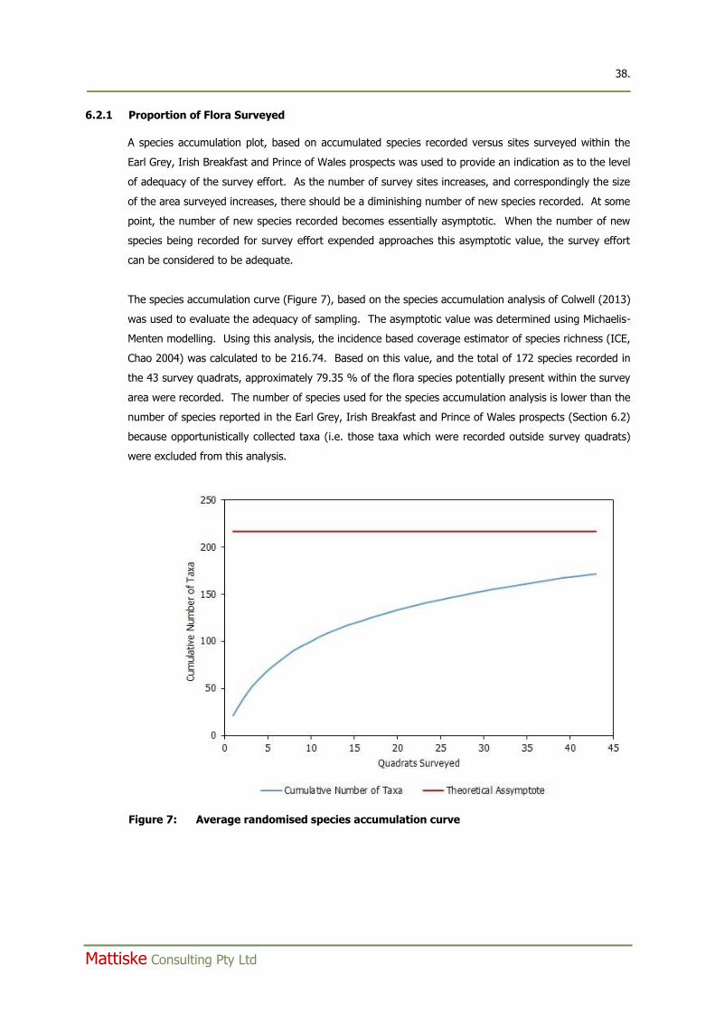
38. ____________________________________________________________________________________________
Mattiske Consulting Pty Ltd
6.2.1 Proportion of Flora Surveyed
A species accumulation plot, based on accumulated species recorded versus sites surveyed within the
Earl Grey, Irish Breakfast and Prince of Wales prospects was used to provide an indication as to the level
of adequacy of the survey effort. As the number of survey sites increases, and correspondingly the size
of the area surveyed increases, there should be a diminishing number of new species recorded. At some
point, the number of new species recorded becomes essentially asymptotic. When the number of new
species being recorded for survey effort expended approaches this asymptotic value, the survey effort
can be considered to be adequate.
The species accumulation curve (Figure 7), based on the species accumulation analysis of Colwell (2013)
was used to evaluate the adequacy of sampling. The asymptotic value was determined using Michaelis-
Menten modelling. Using this analysis, the incidence based coverage estimator of species richness (ICE,
Chao 2004) was calculated to be 216.74. Based on this value, and the total of 172 species recorded in
the 43 survey quadrats, approximately 79.35 % of the flora species potentially present within the survey
area were recorded. The number of species used for the species accumulation analysis is lower than the
number of species reported in the Earl Grey, Irish Breakfast and Prince of Wales prospects (Section 6.2)
because opportunistically collected taxa (i.e. those taxa which were recorded outside survey quadrats)
were excluded from this analysis.
Figure 7: Average randomised species accumulation curve
39. ____________________________________________________________________________________________
Mattiske Consulting Pty Ltd
6.2.2 Threatened and Priority Flora
No threatened flora pursuant to Schedule 1 of the Wildlife Conservation Act 1950 and as listed by the
DPaW (2017b) were recorded within the Earl Grey, Irish Breakfast and Prince of Wales prospects. No
threatened flora pursuant to the Environment Protection and Biodiversity Conservation Act 1999 and as
listed by the DotEE (2017a) were recorded within Earl Grey, Irish Breakfast and Prince of Wales
prospects. One threatened flora taxon pursuant to Schedule 1 of the Wildlife Conservation Act 1950 and
as listed by the DPaW (2017b) was recorded outside the eastern boundary of the Earl Grey prospect, at
survey quadrat EG13 (Figure 9.1). This taxon was Banksia sphaerocarpa var. dolichostyla (T). Banksia
sphaerocarpa var. dolichostyla (T) is listed as Vulnerable, pursuant to the Environment Protection and
Biodiversity Conservation Act 1999 and as listed by the DotEE (2017a). The geographical location where
Banksia sphaerocarpa var. dolichostyla (T) was recorded is set out in Appendix F.
Four priority flora taxa, as listed by DPaW (2017g), were recorded within the Earl Grey, Irish Breakfast
and Prince of Wales prospects. The four priority flora recorded were Eutaxia lasiocalyx (P2), Acacia
undosa (P3), Hakea pendens (P3) and Calamphoreus inflatus (P4). These taxa, together with their
geographical locations and populations, are listed in Appendix F. All priority taxa recorded were
identified from specimens collected during the field trip. The population numbers listed in Appendix F
are a minimum, and do not represent a population count based on a targeted search for the taxa.
DPaW threatened and priority report forms for the threatened and priority taxa recorded in the Earl
Grey, Irish Breakfast and Prince of Wales prospects are presented in Appendix G.
6.2.3 Taxa with Range Extensions
Three taxa recorded during the survey of the Earl Grey, Irish Breakfast, and Prince of Wales prospects
represented an extension to their currently known distribution. These taxa were Hakea invaginata,
Centrolepis strigosa subsp. rupestris and Pityrodia loricata. The locations where these taxa were
recorded within the Earl Grey, Irish Breakfast, and Prince of Wales prospects are set out in Table 7.
Hakea invaginata was recorded at six locations (Table 7). The recording of Hakea invaginata in the Earl
Grey and Irish Breakfast prospects represents an approximately 150 km south-eastern extension to its
currently known range. The recording of Centrolepis strigosa subsp. rupestris in the Irish Breakfast
prospect represents an approximately 200 km southern extension to its currently known range. The
recording of Pityrodia loricata in the Prince of Wales prospect represents an approximately 200 km
southern extension to the currently know range. All three taxa are not considered to be of conservation
significance. In this report, 150 km has been used as a basis to determine an extension to the currently
known range for a taxon.
6.2.4 Other Taxa of Significance
Six specimens collected within the Earl Grey, Irish Breakfast and Prince of Wales prospects, representing
three taxa, were deemed to be species of interest by the WAH. These taxa were identified as:
40. ____________________________________________________________________________________________
Mattiske Consulting Pty Ltd
Microcorys sp. (aff. macredieana)
From three separate collections (DA2397, DA2363, AB077), recorded at four survey quadrats (EG03,
EG07, EG15, EG22). Advice from M. Hislop of the WAH is that these specimens are most closely related
to Microcorys macredieana, but differ in regard to some significant taxonomic characters. Typical
Microcorys macredieana occurs in the Great Victoria Desert. Currently, only one collection of this
morphotype exists at the WAH. M. Hislop advises that in the near future it is likely that a new phrase
name will be recognised for this morphotype. The specimens collected within the Earl Grey prospect will
be added to the WAH collection.
Table 7: Locations of taxa with extensions to their known range, recorded within the Earl Grey, Irish Breakfast, and Prince of Wales prospects
Taxon Prospect Quadrat Location (GDA94, zone 50)
Easting (mE) Northing (mN)
Hakea invaginata Earl Grey EG07 758733 6446439
Hakea invaginata Earl Grey EG23 758813 6445504
Hakea invaginata Earl Grey EG06 758855 6446449
Hake invaginata Earl Grey EG10 759746 6446223
Hakea invaginata Irish Breakfast IB09 758957 6447250
Hakea invaginata Irish Breakfast IB08 760048 6447290
Centrolepis strigosa subsp. rupestris
Irish Breakfast IB04 760166 6447657
Pityrodia loricata Irish Breakfast opportunistic 759874 6449800
Baeckea sp.
From two separate collections (DA2405, AB017), recorded at two survey quadrats (EG04, EG25). Advice
from M. Hislop of the WAH is that these two collections belong to a group of species that are to be
published as a new genus ‘Tilophloia’. At the present time there are numerous phrases names
recognised, with many occurring in the Forrestania area. The specimens collected within the Earl Grey
prospect are being held by the WAH for further assessment.
Lepidosperma sp.
From a single collection (DA2408) recorded at quadrat EG04. M. Hislop of the WAH advises that due to
the incomplete state of research related to genus Lepidosperma in Western Australia, it is difficult, and
often impossible, to provide authoritative identifications in Lepidosperma.
6.2.5 Introduced (Exotic) Plant Species
One introduced (exotic) plant taxon was recorded during the survey of the Earl Grey, Irish Breakfast and
Prince of Wales prospects. The introduced taxon recorded was *Centaurium tenuiflorum. This taxon is
listed as Permitted (s11) pursuant to the Biosecurity and Agriculture Management Act 2007 according to
the DAFWA (2017). *Centaurium tenuiflorum was recorded at a single location within the Irish
Breakfast prospect at quadrat IB04 (760166 mE, 6447657 mN, GDA94, zone 50).
41. ____________________________________________________________________________________________
Mattiske Consulting Pty Ltd
*Centaurium tenuiflorum (Gentianaceae) is an erect hairless herb that can grow to 50 cm high. It
produces pink flowers from the months of August to December and is known to occur along drainage
lines, in swamp, and disturbed areas (DPaW 2017g; Hussey et al. 2007).
6.3 Statistical Analysis of Data
Cluster analyses derived from a species-by-site resemblance matrix (Bray-Curtis similarity) grouped
survey sites into discrete clusters based on species composition (dissimilarity/distance increased) (Clarke
and Gorley 2006). Only taxa which could be identified to species level were included in the analysis.
Classification and ordination analyses were conducted on a data matrix of perennial taxa, with singularly
occurring species and annual taxa omitted prior to analysis. This was justified on the basis that
singleton taxa add little additional information, and annuals (desert ephemerals) exhibit high inter-
annual variation in distribution and abundance (Mott 1972, 1973). In addition, the omission of annual
species from the statistical analysis allows for comparison of data from surveys undertaken in different
seasons or survey years. Hierarchical Clustering was used in conjunction with Similarity Profile
(SIMPROF), Similarity Percentages (SIMPER), site descriptions, site photos and aerial photographs;
combining these methods increased the understanding of site inter-relations and thus the ability to
accurately delineate those sites based on species composition.
To down weight the relative contributions of quantitatively dominant species a 4th root transformation of
the data was used for statistical analysis. Preliminary data analysis indicated that this form of
transformation demonstrated discrimination between the survey quadrats which was more reflective of
the vegetation patterns observed in the field. Introduced species, singletons (species recorded at only
one quadrat), annuals and specimens that were not identified down to the species level were excluded
from the analysis. Taxa which were identified to the subspecies and variety levels were revised to the
specific level to reduce the tendency for this to create further statistical variation in analysis which was
considered unwarranted. Computation of similarity matrices was based on the Bray Curtis similarity
measure.
Where appropriate, outliers and small groupings were assigned to broader comparative vegetation units
based on factors including species composition and site descriptions; this is particularly relevant where
survey quadrats were established on ecotones. For the purposes of vegetation mapping, i.e.
extrapolating quadrat data to generalised vegetation communities over broad areas, an inclusive rather
than exclusive approach was adopted for outliers.
Survey quadrat data from the four prospects surveyed in October/November 2016 (Earl Grey, Irish
Breakfast, Prince of Wales and Van Uden) were incorporated into the statistical analysis to delineate
statistically associated groups of quadrats. Although reported separately, Van Uden was included in the
analysis to maintain a holistic and consistent approach to delineating vegetation communities across the
project. Similarity Profile Analysis (SIMPROF) of the 52 survey quadrats identified 13 significantly
associated groups of quadrats. The dendrogram representing the results of the cluster analysis, and the
corresponding 13 statistically dissimilar vegetation types is illustrated in Figure 8. The primary split in
42. ____________________________________________________________________________________________
Mattiske Consulting Pty Ltd
the dendrogram (groups a to e, as compared to groups f to m) was based on the relative abundance of
some key species. Quadrats which formed groups a to e had a greater contribution from of Eucalyptus
flocktoniae subsp. flocktoniae, Melaleuca pauperiflora subsp. fastigiata, Eucalyptus salubris, and
Eucalyptus salmonophloia. In contrast, quadrats which formed groups f to m were more defined by the
contribution from Melaleuca laxiflora, Eucalyptus eremophila, Melaleuca hamata, Thryptomene kochii,
Acacia acuminata, Allocasuarina acutivalvis subsp. acutivalvis, Allocasuarina spinosissima, and
Eucalyptus capillosa subsp. polyclada. Two groups (g and j) were defined by a single quadrat.
Based on the statistical analysis, and field observations, the 13 statistically dissimilar groups derived
from the cluster analysis were used to delineate 13 vegetation communities across the Earl Grey, Irish
Breakfast, Prince of Wales and Van Uden prospects. Based on field observations, the 13 groups of
quadrats identified from the cluster analysis broadly reflected the vegetation communities observed in
the field.
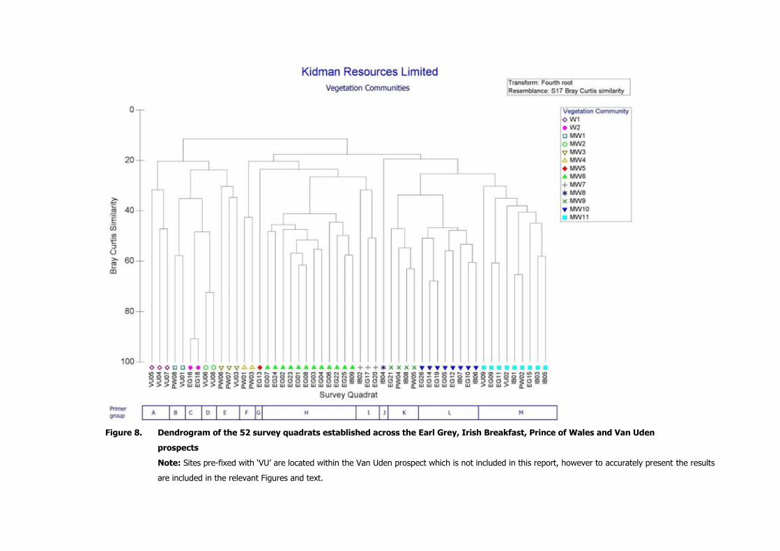
Figure 8. Dendrogram of the 52 survey quadrats established across the Earl Grey, Irish Breakfast, Prince of Wales and Van Uden
prospects
Note: Sites pre-fixed with ‘VU’ are located within the Van Uden prospect which is not included in this report, however to accurately present the results
are included in the relevant Figures and text.
44. ____________________________________________________________________________________________
Mattiske Consulting Pty Ltd
6.4 Vegetation Mapping
Based on the statistical analysis (Section 6.3), 13 vegetation communities were defined and mapped
within the Earl Grey, Irish Breakfast, Prince of Wales and Van Uden prospects. Ten of these vegetation
communities occur within the Early Grey, Irish Breakfast and Prince of Wales prospects and are
described in detail below. In addition to the statistical analysis, survey quadrat physical data and aerial
photographic maps were used to delineate the boundaries of the vegetation communities in the Earl
Grey, Irish Breakfast, Prince of Wales and Van Uden prospects. The descriptions of the vegetation
communities were based on Alpin’s (1979) modification of the vegetation classification system of Specht
(1970), to align with the NVIS. Vegetation communities were described at the association level of the
NVIS classification framework, as defined by the ESCAVI (2003), and are summarised below. A listing of
species recorded within each vegetation community is set out in Appendix H. Detailed descriptions of
each vegetation community together with representative photographs are presented in Appendix I. The
occurrence of each vegetation community in the Earl Grey, Irish Breakfast and Prince of Wales prospects
is set out in Table 8. The vegetation mapped in the Earl Grey, Irish Breakfast and Prince of Wales
prospects is presented in Figures 9.1-9.2.
Table 8: Occurrence of mapped vegetation communities within the Earl Grey, Irish Breakfast and Prince of Wales prospects
Vegetation Community
Prospect
Earl Grey Irish
Breakfast Prince of
Wales
W2 x x
MW3 x
MW4 x
MW5 external1
MW6 x x
MW7 x x
MW8 x x
MW9 x x x
MW10 x
MW11 x x x 1 community situated external to Earl Grey prospect; community W1, MW1 and MW2 occur only in Van
Uden prospect.
Woodlands
W2 Eucalyptus salubris, Eucalyptus flocktoniae subsp. flocktoniae low woodland over Melaleuca
pauperiflora subsp. fastigiata, Melaleuca halmaturorum, Daviesia argillacea mid open shrubland
over Microcybe ambigua low sparse heathland on pale orange clayey sand flats.
Mallee Woodlands
MW3 Eucalyptus eremophila, Eucalyptus flocktoniae subsp. flocktoniae, Eucalyptus prolixa mid open
mallee woodland over Daviesia argillacea, Acacia hemiteles low sparse shrubland over Acacia
deficiens, Coopernookia strophiolata low sparse heathland on brown clay loam, occasionally with
ironstone pebbles, on flats.
45. ____________________________________________________________________________________________
Mattiske Consulting Pty Ltd
MW4 Eucalyptus capillosa subsp. polyclada mid open mallee woodland over Baeckea elderiana,
Allocasuarina acutivalvis subsp. acutivalvis, Grevillea didymobotrya subsp. didymobotrya mid-tall
sparse shrubland on orange-brown clay, occasionally with ironstone pebbles, on flats and mid
slopes.
MW5 Eucalyptus burracoppinensis, Allocasuarina acutivalvis subsp. acutivalvis, Callitris canescens low
open mallee woodland over Banksia purdieana, Beaufortia orbifolia, Allocasuarina spinosissima
mid open shrubland over Gompholobium hendersonii, Goodenia pinifolia low isolated shrubs on
yellow-brown clay loam on flats.
MW6 Eucalyptus burracoppinensis, Eucalyptus eremophila mid open mallee woodland over
Thryptomene kochii, Melaleuca laxiflora, Acacia acuminata mid open shrubland over
Drummondita hassellii, Microcybe ambigua low sparse heathland on grey-brown to orange-brown
clay to clay sand, often with scattered ironstone pebbles on flats.
MW7 Eucalyptus capillosa subsp. polyclada, Eucalyptus eremophila mid open mallee woodland over
Allocasuarina acutivalvis subsp. acutivalvis, Hakea subsulcata, Melaleuca hamata mid-tall sparse
shrubland over Hibbertia exasperata, Phebalium megaphyllum low sparse shrubland on orange-
brown to brown clay to loamy clay, with occasional ironstone pebbles, on flats and slopes.
MW8 Eucalyptus eremophila mid open mallee woodland over Melaleuca hamata, Leptospermum
erubescens, Melaleuca lateriflora mid sparse shrubland over Thomasia sp. Salmon Gums (C.A.
Gardner s.n. PERTH 02708639), Darwinia sp. Karonie (K. Newbey 8503) low sparse shrubland on
orange brown clay in minor drainage channel.
MW9 Eucalyptus rigidula, Eucalyptus capillosa subsp. capillosa mid mallee woodland over Melaleuca
acuminata subsp. acuminata, Melaleuca hamata, Melaleuca laxiflora mid open shrubland over
Grevillea acuaria, Cryptandra minutifolia subsp. brevistyla, Dodonaea bursariifolia low sparse
heathland on brown to red-brown clay loam soils on flats and lower slopes.
MW10 Eucalyptus rigidula, Eucalyptus eremophila, Eucalyptus flocktoniae subsp. flocktoniae mid mallee
woodland over Melaleuca laxiflora, Melaleuca lateriflora, Melaleuca hamata mid open shrubland
over Daviesia argillacea, Acacia hystrix subsp. hystrix, Grevillea acuaria low sparse heathland on
yellow to pale orange-brown clay sands with occasional scattered ironstone pebbles on flats.
MW11 Eucalyptus eremophila, Eucalyptus incrassata, Eucalyptus prolixa mid mallee woodland over
Melaleuca halmaturorum, Melaleuca lateriflora, Melaleuca hamata mid sparse shrubland over
Daviesia scoparia, Acacia mackeyana low sparse heathland on grey-brown to orange-brown clay
and clay sands on flats and slopes.
CL Cleared land
6.5 Area Coverage of Vegetation Communities
The total areas mapped for each vegetation community across the three prospects is set out in Table 9.
The areas mapped and percentage cover for each vegetation community delineated in the Earl Grey,
Irish Breakfast and Prince of Wales prospects is set out in Table 10. In terms of the areas surveyed,
cleared land occupied the greatest proportion of the total area surveyed, comprising 16.20% of the total
area. Eucalypt mallee woodlands with a myrtaceous, predominantly Melaleuca, understorey was the
most dominant vegetation type mapped (communities MW6, MW10, MW11), comprising 58.90% of the
three prospects. Several vegetation communities (W2, MW4, MW7, MW8 and MW9) occupied less than
10% of the total areas mapped, but were variations on the eucalypt mallee woodlands over Melaleuca
46. ____________________________________________________________________________________________
Mattiske Consulting Pty Ltd
shrubland type vegetation. Average species richness across all 52 quadrats was 20.87 ± 1.11 (mean ±
s.e.m.). The MW6 vegetation community exhibited the highest species richness (28.33 ± 2.49).
6.6 Condition of the Vegetation
The condition of the vegetation within the Earl Grey, Irish Breakfast and Prince of Wales prospects
ranged from Excellent to Completely Degraded, according to the Trudgen (1988; Appendix A7) scale.
Within the Earl Grey, Irish Breakfast and Prince of Wales prospects these areas can be delineated as
follows:
Excellent: Areas of vegetation where no exploration or drill tracks encroach, typically at
least 20 m distant from tracks.
Good to Very Good: Areas between tracks and drill lines, typically 5 m to 20 m from track/drill line
edge.
Poor: Areas bordering tracks and drill lines.
Very Poor: Old waste mounds and old tracks which have had some past attempts at
rehabilitation.
Completely Degraded: Old mine pits and surrounds.
Considering the extent of past mining operations and the degree of impacts associated with tracks and
drill lines, the absence of weed species is remarkable.
Table 9: Total area coverage of each vegetation community mapped across the Earl Grey,
Irish Breakfast and Prince of Wales prospects.
Vegetation Community Area (ha) Percentage of Total Area
Surveyed
W1 0.00 0.00
W2 12.31 2.45
MW1 0.00 0.00
MW2 0.00 0.00
MW3 79.46 15.81
MW4 3.52 0.70
MW5 0.00 0.00
MW6 101.01 20.10
MW7 4.48 0.89
MW8 1.03 0.20
MW9 24.37 4.85
MW10 52.92 10.53
MW11 142.12 28.27
Cleared Land 81.42 16.20
Total Area 502.64 100.00
Community MW5 was derived from a single survey quadrat located external to the Earl Grey prospect; community W1, MW1 and MW2 occur only in Van Uden prospect.
47. ____________________________________________________________________________________________
Mattiske Consulting Pty Ltd
Table 10: Area coverage of each vegetation community within the Earl Grey, Irish Breakfast and Prince of Wales prospects.
Vegetation Community Area (ha) Percentage of Survey
Area
Earl Grey prospect
W2 8.24 3.50
MW6 64.94 27.58
MW7 1.39 0.59
MW9 4.78 2.03
MW10 52.92 22.47
MW11 69.18 29.38
Cleared Land 34.03 14.45
Total Area 235.48 100.00
Irish Breakfast prospect
MW6 36.08 28.42
MW7 3.09 2.43
MW8 1.03 0.81
MW9 14.18 11.17
MW11 35.35 27.85
Cleared Land 37.20 29.31
Total Area 126.92 100.00
Prince of Wales prospect
W2 4.07 2.90
MW3 79.46 56.66
MW4 3.52 2.51
MW9 5.41 3.86
MW11 37.59 26.80
Cleared Land 10.18 7.26
Total Area 140.23 100.00
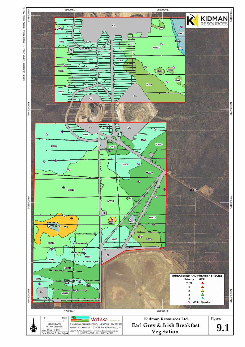
759000mE
6445
000m
N
759000mE
6445
000m
N
Aer
ial:
Land
gate
(M
arch
201
1) ~
Thr
eate
ned
& P
riorit
y F
lora
: MC
PL
6446
000m
N64
4700
0mN
6448
000m
N
6446
000m
N64
4700
0mN
6448
000m
N
760000mE
760000mE
Figure:
9.1
CLCL
CLCLCLCL
CLCL
MW9MW9
MW9MW9 MW9MW9
MW9MW9
MW9MW9
MW11MW11
MW11MW11
MW11MW11
MW6MW6
MW6MW6
MW6MW6
MW6MW6
MW7MW7
MW8MW8
CLCL CLCL
CLCL
CLCL
CLCL
MW6MW6
MW6MW6
MW6MW6
MW6MW6
MW6MW6
MW6MW6MW6MW6
MW6MW6
MW6MW6
MW7MW7
MW7MW7W2W2
W2W2
MW9MW9
MW10MW10
MW10MW10
MW10MW10
MW10MW10
MW10MW10
MW10MW10
MW11MW11
MW11MW11
MW11MW11
Priority
1234
THREATENED AND PRIORITY SPECIES
T / XMCPL
MCPL Quadrat
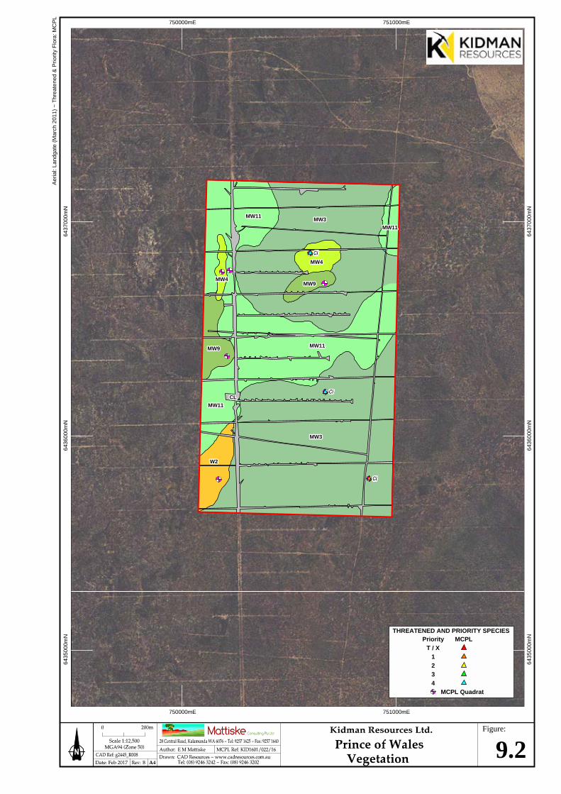
750000mE
6435
000m
N
750000mE
6435
000m
N
Aer
ial:
Land
gate
(M
arch
201
1) ~
Thr
eate
ned
& P
riorit
y F
lora
: MC
PL
6436
000m
N64
3700
0mN
6436
000m
N64
3700
0mN
751000mE
751000mE
Figure:
9.2
MW3MW3
MW3MW3
MW11MW11
MW11MW11
MW11MW11
MW11MW11
MW4MW4
MW4MW4
MW9MW9
MW9MW9
CLCL
W2W2
Priority
1234
THREATENED AND PRIORITY SPECIES
T / XMCPL
MCPL Quadrat
50. ____________________________________________________________________________________________
Mattiske Consulting Pty Ltd
7. DISCUSSION
Mattiske was commissioned by Kidman to undertake a survey of the Earl Grey, Irish Breakfast and Prince
of Wales prospects. The three prospects occupy a combined area of 502.64 ha and are situated at the
historic Mt Holland Project, south of Southern Cross, near Mt Holland. During the survey a concurrent
search was made to determine if any flora of conservation significance were present in any of the three
prospects. This was particularly important as the threatened taxon, Banksia sphaerocarpa var.
dolichostyla was known to be present in the vicinity of the Mt Holland Project area (Convergent Minerals
Limited 2014).
The field surveys of the Earl Grey, Irish Breakfast and Prince of Wales prospects took place in October
and November 2016. A review of the potential constraints associated with these surveys determined
that the surveys were not subject to constraints that would adversely affect the outcome of the surveys
nor the conclusions formed from the results (section 6.1). A total of 43 vegetation survey quadrats were
established across the three prospects – 26 in the Earl Grey prospect, nine in the Irish Breakfast
prospect and eight in the Prince of Wales prospect. These quadrats were established to help verify the
results from the desktop assessment and provide data to broadly map the vegetation communities
present. The data recorded in the vegetation quadrats, together with observation made whilst
traversing the three prospects also assisted in determining if the area supported any conservation
significant flora or vegetation.
Flora
A total of 184 vascular plant taxa which are representative of 86 genera and 35 families were recorded
in the Earl Grey, Irish Breakfast and Prince of Wales prospects. The majority of taxa recorded were
representative of the Myrtaceae (46 taxa), Fabaceae (30 taxa), and Proteaceae (19 taxa) families
(Appendix C). Species which were classified as strictly annual represented 9.9 % of all taxa recorded.
Of the 407 plant specimens collected during the October and November 2016 surveys, six could not be
identified to the species level, either because they were from burnt specimens which lacked sufficient
diagnostic features, or as was the case with specimens identified as Baeckea sp. or Lepidosperma sp.,
current taxonomic revisions precluded making accurate determinations (M. Hislop, WAH, pers. comm.).
A further 20 specimens were identified to the species level with some degree of uncertainty. Specimens
which could either not be identified accurately by Mattiske or which were suspected of potentially being
of conservation significance were submitted to the WAH for formal identification.
Rainfall in the months preceding the surveys was close to average (Figure 3) for the area. The majority
of flora were either flowering or were nearing the end of their flowering period during the surveys. This
afforded a good opportunity to collect excellent specimens to enable accurate identifications. However,
there were less annual species recorded than expected. Given the number of Orchidaceae which were
recorded as part of the desktop assessment, where they represented the third most commonly
represented family after the Myrtaceae and Fabaceae, they were virtually absent during the October and
November 2016 field surveys. There was a similarly low level of annual taxa recorded during October
and November 2016 field surveys, and those that were recorded were already either dead or close to
51. ____________________________________________________________________________________________
Mattiske Consulting Pty Ltd
senescence. This suggests that an earlier survey in late winter may be more appropriate to record
annual species in the area.
Several flora of conservation significance were recorded during the October and November 2016 field
surveys. The most significant taxon recorded was Banksia sphaerocarpa var. dolichostyla (T). This
taxon was not recorded within either the Earl Grey, Irish Breakfast or Prince of Wales prospects. It was
recorded at a location approximately 200 m from the eastern side of the Earl Grey prospect, in a
vegetation community which is bisected by an old haul road (Figure 9.1). This taxon, nor the soil or
landforms on which it was growing, was recorded in any of the three prosects surveyed. However, its
proximity to the Earl Grey prospect, and hence potential for disturbance as a result of future mining
operations, warrants management to minimise impacts. This is particularly important given that this
taxon is generally restricted to the Mt Holland area (Convergent Minerals Limited 2014). Four priority
listed taxa (DPaW 2017g) were recorded within the Earl Grey, Irish Breakfast or Prince of Wales
prospects. These were Eutaxia lasiocalyx (P2), Acacia undosa (P3), Hakea pendens (P3), and
Calamphoreus inflatus (P4) (Figure 9, Appendices C and F). All four taxa were recorded infrequently.
However, given that the October and November 2016 surveys were of a reconnaissance nature, it is
highly probable that more records of these taxa would be made during an intensive search.
Calamphoreus inflatus (P4) was recorded only in the Prince of Wales prospect in areas which had been
burnt approximately 18 months prior to the currently reported field survey. This was consistent with this
taxon being known to occur on disturbed sites (DPaW 2017g). The desktop assessment recorded 54
taxa of conservation significance with the potential to be recorded in the vicinity of the Earl Grey, Irish
Breakfast or Prince of Wales prospects (Table 4). Twenty-three of these taxa were assessed (Table 4;
Appendix D) as having a high (one taxa) or medium (22 taxa) potential to be recorded within the Earl
Grey, Irish Breakfast or Prince of Wales prospects. Similarly, records of the DPaW and WAH indicate a
range of conservation significant flora recorded near to the Earl Grey, Irish Breakfast or Prince of Wales
prospects (Figure 6).
Two flora taxa, considered by the WAH to be of significance, either in terms of their potential to
represent new taxa or to be in need of further assessment, were collected during the October and
November 2016 field surveys of the Earl Grey prospect. These two taxa are listed (Appendix C) as
Microcorys sp. (aff. macredieana) and Baeckea sp. Microcorys sp. (aff. macredieana) is most closely
related to Microcorys macredieana, but differs in regard to some significant taxonomic characters (M.
Hislop, WAH, pers. comm.). Typical Microcorys macredieana occurs in the Great Victoria Desert.
Currently, only one collection of this morphotype exists at the WAH. M. Hislop, of the WAH, advises that
in the near future it is likely that a new phrase name will be recognised for this morphotype. Baeckea
sp. belongs to a group of species that are to be published as a new genus ‘Tilophloia’ (M. Hislop, WAH,
pers. comm.). At the present time there are numerous phrases names recognised, with many occurring
in the Forrestania region. The specimens of these taxa collected during the October and November
2016 surveys have/will be submitted to the WAH. Similar to the comments made in regard of
conservation significant taxa recorded, it is likely that more specimens of Microcorys sp. (aff.
macredieana) and Baeckea sp. would be recorded during a more intensive survey of the Earl Grey, Irish
Breakfast or Prince of Wales prospects and their surrounds.
52. ____________________________________________________________________________________________
Mattiske Consulting Pty Ltd
Only one introduced flora taxon was recorded in the Earl Grey, Irish Breakfast or Prince of Wales
prospects during the October/November 2016 field surveys. This was *Centaurium tenuiflorum, an
introduced species which is listed as Permitted (s11) pursuant to the BAM Act according to the DAFWA
(2017). Given the extent of disturbance, in terms of drill tracks, old mine pits and waste mounds, it is
notable that more introduces species were not recorded.
Vegetation
Quadrat based species data from the four prospects (including van Uden) surveyed in October and
November 2016 was used for the statistical analysis used to inform vegetation community delineation
and definition. The four prospects: Earl Grey, Irish Breakfast, Prince of Wales and Van Uden, are close
to each other (Figure 2). It was not appropriate to analyse the quadrat based data for each prospect in
isolation. The reasons for this are that: 1) given the close proximity of all four prospects to each other
there is the likelihood that there would be shared vegetation communities, and 2) undertaking a
statistical analysis of each prospect in isolation may result in greater, and unwarranted vegetation
community delineation.
The results of the statistical analysis, based on the combined 52 survey quadrats across the four
prospects are presented in the form of a dendrogram (Figure 8). Two of the 13 statistically different
groups (groups a and e) were uniquely associated with the Van Uden prospect and are not included in
this report. Another two statistically different groups were represented by a single quadrat (groups g
and j). The remaining nine statistically different groupings were variously distributed amongst the four
prospects (Table 8). The single quadrat groups were also noted as being unique during the course of
the field survey work. Group g, which occurred outside the eastern boundary of the Earl Grey prospect
not only comprised a unique assemblage of species, but was also the location of the threatened species
Banksia sphaerocarpa var. dolichostyla. The other single quadrat represented statistical group was
group j, which occurred in the north eastern section of the Irish Breakfast prospect, and comprised an
assemblage of species which are situated in a low lying drainage area at the base of a low rise to the
north east of the Irish Breakfast prospect. The remainder of the statistically differentiated groupings of
quadrats comprise variations on the dominant vegetation patterning in the prospect, particularly the
dominant Eucalyptus or Melaleuca species. Overall much of the vegetation of the Earl Grey, Irish
Breakfast and Prince of Wales prospects can be broadly described as Eucalyptus mallee woodlands over
Melaleuca shrubland. The patterning of the vegetation observed represented a mosaic of mallee
woodland interspersed with Allocasuarina scrub. The mapping of the vegetation communities made use
of low level resolution aerial maps - high resolution imagery was not available at the time of the surveys
or report preparation. Given that the present survey was a reconnaissance survey, with an appropriately
low density of survey quadrats, the mapping of the vegetation communities may be subject to future
refinement and boundary modification should further survey work be undertaken. Verbal advice from
Kidman indicates that higher resolution aerials will become available in 2017. Should additional survey
work be undertaken in the Earl Grey, Irish Breakfast, or Prince of Wales prospects, the combination of
higher quality aerial maps and establishment of additional survey quadrats should enable a finer
resolution of the vegetation present in these prospects.
53. ____________________________________________________________________________________________
Mattiske Consulting Pty Ltd
Notwithstanding these limitations, 13 vegetation communities were defined and mapped, based on the
results of the statistical analysis of the data from the 52 quadrats (Figures 9.1-9.2). There may be some
justification in merging some communities into larger, more generalised groups of mallee woodlands.
This was not undertaken for this report because the vegetation communities mapped broadly reflected
the different vegetation communities observed in the field. The dominant vegetation communities,
MW6, MW10 and MW11 accounted for 55% of all the survey quadrats. Eucalyptus eremophila was a
common species in all three communities, with Eucalyptus burracoppinensis forming a dominant
component of community MW6, Eucalyptus flocktoniae subsp. flocktoniae in community MW10 and
Eucalyptus incrassata and Eucalyptus prolixa being co-dominant in community MW11. All three
communities had varying levels of dominance of a range of Melaleuca and Acacia species. Parts of the
Prince of Wales prospect had been burnt approximately 18 months prior to the October/November 2016
field survey. Whilst efforts were made to select undisturbed vegetation for quadrat establishment, there
is the potential that some of the variation observed in the Prince of Wales prospect may be attributed to
species successional changes associated with the recent fires.
Overall, the species recorded during the field survey, and the vegetation communities subsequently
defined, are typical of the flora and vegetation which has been previously reported historically in the
Forrestania region by Beard (1972, 1990), and in the more recent surveys in the vicinity of the Mt
Holland gold mine (Craig 2006, Native Vegetation Solutions 2014, Convergent Minerals Limited 2014,
Native Vegetation Solutions 2016a). The latter surveys (refer to Section 5.6) describe both flora species
(Appendix C) and vegetation communities similar to those recorded during the present survey. That is,
Eucalyptus mallee woodlands over Melaleuca shrublands and Eucalyptus salmonophloia woodlands.
Given that Native Vegetation Solutions (2016a) have completed a Level 1 survey associated with drill
lines in the Jilbadji Nature Reserve, approximately 800 m to the north of the Prince of Wales prospect,
the incorporation of the quadrat based data from this survey, together with quadrat based data from the
survey of the Blue Vein Mine (Native vegetation Solutions 2014), some 5 km to the south of the Earl
Grey prospect, should be considered, assuming the data is available in a suitable format. This would
enable a geographically broader assessment of the vegetation communities present, and ultimately any
potential impacts to each community resulting from clearing associated with mine development to be
assessed.
In terms of the areas surveyed, cleared land occupied the greatest proportion of the total area surveyed,
comprising one fifth of the total area. Eucalypt mallee woodlands with a Myrtaceous, predominantly
Melaleuca, understorey was the most dominant vegetation type mapped (communities MW6, MW10,
MW11), comprising 43.48% of the areas surveyed. Several vegetation communities (MW4, MW7 and
MW9) occupied less than 5% of the total areas mapped, but were variations on the eucalypt mallee
woodlands over Melaleuca shrubland type vegetation.
In term of area coverage of the defined vegetation communities, eucalypt mallee woodlands with a
myrtaceous, predominantly Melaleuca, understorey were the most dominant vegetation type mapped
across the Earl Grey, Irish Breakfast and Prince of Wales prospects (communities MW6, MW10, MW11),
comprising 58.90% of the areas surveyed. Cleared areas of land, comprising old pits, waste mounds,
54. ____________________________________________________________________________________________
Mattiske Consulting Pty Ltd
access and drill tracks amounted to nearly one fifth (16.20%) of the total area surveyed. Whilst some of
the defined vegetation communities had a low level of representation within the Earl Grey, Irish
Breakfast, or Prince of Wales prospects, with the exception of community MW5, which lies external to
the Earl Grey prospect, none comprised species or species assemblages which represent vegetation
which is especially unique. Vegetation community MW5 was unique both in its species assemblage, and
in particular that it is the location of Banksia sphaerocarpa subsp. dolichostyla (T). Other examples of
this community were not recorded within either the Earl Grey, Irish Breakfast, or Prince of Wales
prospects. Whilst this vegetation community is not specifically within the Earl Grey prospect, its
proximity to an existing haul road and potential area to be mined, warrants measures being taken to
minimise impacts to this vegetation.
The Earl Grey, Irish Breakfast and Prince of Wales prospects are situated wholly within the buffer of the
Ironcap Hills Vegetation Complexes (Mt Holland, Middle, North and South Ironcap Hills, Digger Rock and
Hatter Hill) (banded ironstone), a Priority 3 ecological community (Figure 6). All three prospects are
situated near the western boundary of this PEC. Gibson (2004a) established a number of survey
quadrats on the Middle, and South Ironcap, Digger Rock and Hatter Hill, as part of a series of detailed
floristic studies of the ranges of the Eastern Goldfields. The survey quadrats established by Gibson
(2004a) were principally sited on skeletal soils derived from banded ironstone and massive laterites, or
on deeper soils derived from greenstone or decomposing laterites (Gibson 2004a). Gibson delineated
four principal vegetation community types:
Community 1: Species rich shrubland or mallee shrubland on massive outcrops along the Middle
Ironcap, South Ironcap, Digger Rock and Hatter Hill);
Community 2: Mallee shrublands or Allocasuarina thickets found on massive laterites;
Community 3: Eucalypt woodlands dominated or co-dominated by Eucalyptus urna and Eucalyptus
salubris occurring on colluvial deposits on the flats below the outcrops or on the broad
flat ridges along the ranges, with an understorey dominated by Melaleuca spp.; and
Community 4: Species poor mallee community generally dominated by Eucalyptus calycogona with
large emergent Eucalyptus salmonophloia on small colluvial flats in the ranges.
Banded ironstone formations or any form of outcropping was not present within the Earl Grey, Irish
Breakfast or Prince of Wales prospects. The terrain of the three prospects was gently undulating flats
with occasional low rises, none of which exhibited any outcropping. Whilst the above listed community
types are not necessarily the only vegetation types which would be associated with the Ironcap Hills
Vegetation Complexes (P3), the absence of any of the listed communities, and associated landforms,
together with the peripheral location of the Earl Grey, Irish Breakfast and Prince of Wales prospects with
respect to the PEC buffer, would support the proposition that the three prospects are not of
consequence in relation to the Ironcap Hills Vegetation Complexes (P3). For this these reasons, and
because the present survey was reconnaissance in nature, no statistical analysis was undertaken to
compare data from Gibson’s (2004a) survey quadrats with the data recorded in the present survey to
determine any level of similarity, and hence potential association with the PEC.
55. ____________________________________________________________________________________________
Mattiske Consulting Pty Ltd
8. CONCLUSIONS AND RECOMMENDATIONS
Overall, the vegetation communities mapped and species recorded in the Earl Grey, Irish Breakfast, and
Prince of Wales prospects were consistent with the historical mapping of Beard (1972, 1990) and the
more recent localised surveys (Craig 2006, Native Vegetation Solutions 2014, Convergent Minerals
Limited 2014, Native Vegetation Solutions 2016a). The majority of the Earl Grey, Irish Breakfast and
Prince of Wales prospects are situated on sandy, sandy clay or clay loam flats and gentle slopes
supporting Eucalyptus mallee woodlands over Melaleuca shrublands. The priority taxa Eutaxia lasiocalyx
(P2), Acacia undosa (P3), Hakea pendens (P3), and Calamphoreus inflatus (P4) were recorded
infrequently across the three prospects. The threatened taxon, Banksia sphaerocarpa var. dolichostyla
(T), was recorded approximately 200m outside the eastern boundary of the Earl Grey prospect.
None of the vegetation communities defined within the three prospects represents vegetation which
could be classified as unique or restricted in the region. There is a considerable degree of disturbance
in all three prospects, in terms of access tracks and drill tracks, particularly form past mining and
exploration activities. In addition, both the Earl Grey and Irish Breakfast prospects have large areas of
disturbance and clearing associated with old mine pits and waste mounds. These cleared areas totalled
16.20% of the areas surveyed. Whilst the Earl Grey, Irish Breakfast and Prince of Wales prospects are
situated wholly within the buffer of the Ironcap Hills Vegetation Complexes (P3) PEC, given that the
vegetation present in all three prospects was typical of the region and that there were no banded
ironstone hills outcropping present, it is likely that impacts to the PEC are peripheral and minor in their
extent.
The principal issue with respect to the flora and vegetation surveyed is in relation to the presence of
Banksia sphaerocarpa var. dolichostyla (T) in the vicinity of the Earl Grey prospect. It would be
appropriate, in the event of future mine development, to put in place a management plan to minimise
impacts to this species and the associated vegetation.
56. ____________________________________________________________________________________________
Mattiske Consulting Pty Ltd
9. ACKNOWLEDGEMENTS
The author would like to thank Mr Mike Hislop of the Western Australian Herbarium for his assistance in
identifying a number of the flora collected during the course of the field survey work.
10. LIST OF PERSONNEL
The following Mattiske Consulting Pty Ltd personnel were involved in this project:
Name Position Survey Involvement
Flora Collection Permit
Dr E.M. Mattiske Managing Director & Principal Ecologist
planning, management & reporting
N/A
Mr D. Angus Senior Botanist fieldwork, data analysis, plant identifications, mapping, report preparation
SL011706 3-1617
Dr S. Ruoss Experienced Botanist fieldwork SL011718
Ms N, Murdock Senior Botanist assisting in editing report
N/A
Mr A. Barrett Experienced Botanist fieldwork SL011707
Mr B. Ellery Experienced Botanist / Taxonomist
plant identifications N/A
11. REFERENCES
Alpin, T.E.H. (1979) The Flora. In Environment and Science. Editor B.J. O’Brien, University of Western Australia Press, Perth, Western Australia.
Beard, J.S. (1969) The vegetation of the Boorabbin and Lake Johnstone areas, Western Australia. Proc. Linn. Soc.
NSW 93: 239-269. Beard J.S. (1972)
Vegetation survey of Western Australia. The Vegetation of the Hyden Area, Western Australia. Map and explanatory memoir. 1:250,000 series. Vegmap Publications, Sydney.
Beard, J.S. (1990)
Plant Life of Western Australia. Kangaroo Press, Kenthurst NSW. Beecham, B. (2001) Avon Wheatbelt 1 (AW1 - Ancient Drainage subregion). In: A Biodiversity Audit of Western
Australia's 53 Biogeographical Subregions in 2002. Western Australian Government Department of Environment and Conservation, Perth, Western Australia.
Beecham, B. and Danks, A. (2001) Mallee 2 (MAL2 - Western Mallee subregion). In: A Biodiversity Audit of Western Australia's 53
Biogeographical Subregions in 2002. Western Australian Government Department of Environment and Conservation, Perth, Western Australia.
Biodiversity Conservation Act 2016 (WA)
57. ____________________________________________________________________________________________
Mattiske Consulting Pty Ltd
Biosecurity and Agriculture Management Act 2007 (WA) Biosecurity and Agriculture Management Regulations 2013 (WA) Bureau of Meteorology (2017) Climate averages for specific sites. Accessed 9th February 2017.
<http://www.bom.gov.au/climate/data/>
Chao, A. (2004) Species richness estimation. In Balakrisnan, N., Read, C.B. and Vidakovic, B, eds., Encyclopaedia of Statistical Sciences. Wiley, New York.
Clarke, K.R., and Gorley, R.N. (2006) PRIMER v6: User Manual/Tutorial. PRIMER-E: Plymouth. Colwell, R.K. (2013)
EstimateS: Statistical estimation of species richness and shared species from samples. Version 9. Persistent URL <purl.oclc.org/estimates>.
Convergent Minerals Limited (2014)
Threatened Flora Management Plan for Banksia sphaerocarpa var. dolichostyla. Mt. Holland Gold Project Blue Vein Operations DRAFT V2.0., October 2014.
Cowan, M., Graham, G. and McKenzie, N (2001)
Coolgardie 2 (C002 – Southern Cross Subregion). In: A Biodiversity Audit of Western Australia's 53 Biogeographical Subregions in 2002. Western Australian Government Department of Environment and Conservation, Perth, Western Australia.
Craig, G.F. (2006)
Bounty JV - Tenements M77/1080, M77/1065, M77/1066, M77/1067, M77/1068 - Declared Rare and Priority Survey. Unpublished report prepared for Nickel Australia Limited.
Department of Agriculture and Food Western Australia (2017) Western Australian Organism List. Accessed 9th February 2017.
<https://www.agric.wa.gov.au/bam/western-australian-organism-list-waol> Department of Parks and Wildlife (2007-)
NatureMap, Mapping Western Australia’s Biodiversity. Accessed 24th November 2016. <http://naturemap.dec.wa.gov.au>
Department of Parks and Wildlife (2017a)
Western Australian Flora Statistics. Accessed 9th February 2017. <http://florabase.dpaw.wa.gov.au/statistics/>
Department of Parks and Wildlife (2017b)
Wildlife Conservation (Rare Flora Notice 2016) 6th January 2017. Accessed 9th February 2017. <https://www.dpaw.wa.gov.au/images/documents/plants-animals/threatened-species/Listings/flora_notice.pdf>
Department of Parks and Wildlife (2017c) Western Australian Flora Conservation taxa. Accessed 9th February 2017. <https://www.dpaw.wa.gov.au/images/documents/plants-animals/threatened-species/Listings/conservation_code_definitions.pdf>
Department of Parks and Wildlife (2017d)
Definitions, Categories and Criteria for Threatened and Priority Ecological Communities. Accessed 9th February 2017. <https://www.dpaw.wa.gov.au/images/plants-animals/threatened-species/definitions_categories_and_criteria_for_threatened_and_priority_ecological_communities.pdf>
58. ____________________________________________________________________________________________
Mattiske Consulting Pty Ltd
Department of Parks and Wildlife (2017e) List of Threatened Ecological Communities (TEC’s) endorsed by the Minister for the Environment, 6th October 2016. Accessed 9th February 2017. <https://www.dpaw.wa.gov.au/images/plants-animals/threatened-species/threatened_ecological_communities_endorsed_by_the_minister_october_2016.pdf>
Department of Parks and Wildlife (2017f)
Priority Ecological Communities for Western Australia Version 26 (30th November 2016). Accessed 9th February 2017. <https://www.dpaw.wa.gov.au/images/plants-animals/threatened-species/priority_ecological_community_list_wa_version_26.pdf>
Department of Parks and Wildlife (2017g)
Florabase, the Western Australian Flora. Accessed 9th February 2017. <http://florabase.dpaw.wa.gov.au>
Department of the Environment and Energy (2017a)
Environment Protection and Biodiversity Conservation Act 1999 List of Threatened Flora. Accessed 9th February 2017. <http://www.environment.gov.au/cgi-bin/sprat/public/publicthreatenedlist.pl?wanted=flora>
Department of the Environment and Energy (2017b)
Environment Protection Biodiversity Conservation Act 1999 List of Threatened Ecological Communities. Accessed 9th February 2017. <http://www.environment.gov.au/cgi-bin/sprat/public/publiclookupcommunities.pl>
Department of the Environment and Energy (2017c) Protected Matters Search Tool. Accessed 8th February 2017.
<https://www.environment.gov.au/epbc/protected-matters-search-tool> Department of the Environment and Energy (2017d) Australia's bioregions (IBRA). Accessed 9th February 2017.
<http://www.environment.gov.au/topics/land/national-reserve-system/science-maps-and-data/australias-bioregions-ibra>
Department of the Environment and Energy (2017e) Jilbadji Nature Reserve, Forrestania - Southern Cross Rd, Barker Lake via Marvel Loch, WA,
Australia. Accessed 9th February 2017. < http://www.environment.gov.au/cgi-bin/ahdb/search.pl?mode=place_detail;place_id=9790>
Department of the Environment and Energy (2017f) Weeds of national Significance. Accessed 9th February 2017.
<http://www.environment.gov.au/biodiversity/invasive/weeds/weeds/lists/wons.html> Environmental Protection Authority (2016a) Environmental Factor Guideline: Flora and Vegetation. EPA, Western Australia.
Environmental Protection Authority (2016b) Technical Guidance – Flora and Vegetation Surveys for Environmental Impact Assessment.
EPA, Western Australia. Environmental Protection Authority and Department of Parks and Wildlife (2016) Environmental Factor Guideline: Flora and Vegetation. EPA, Western Australia. Environmental Protection Act 1986 (WA) Environment Protection and Biodiversity Conservation Act 1999 (Cth) Environmental Protection (Clearing of Native Vegetation) Regulations 2004 (WA)
59. ____________________________________________________________________________________________
Mattiske Consulting Pty Ltd
Executive Steering Committee for Australian Vegetation Information (ESCAVI) (2003) Australian Vegetation Attribute Manual: National Vegetation Information System, Version 6.0. Department of the Environment and Heritage, Canberra.
Gibson, N. (2004a) Flora and vegetation of the Eastern Goldfield Ranges, Part 7: Middle and South Ironcap, Digger
Rock and Hatter Hill. Journal of the Royal Society of Western Australia 87: 49-62. Gibson, N. (2004b) Flora and vegetation of the Eastern Goldfield Ranges, Part 6: Mt Manning Range. Journal of the
Royal Society of Western Australia 87: 35-47. Gibson, N. and Lyons M.N. (1998a) Flora and vegetation of the Eastern Goldfield Ranges, Part 2: Bremer Range. Journal of the
Royal Society of Western Australia 81: 107-117. Gibson, N. and Lyons M.N. (1998b) Flora and vegetation of the Eastern Goldfield Ranges, Part 3: Parker Range. Journal of the
Royal Society of Western Australia 81: 119-129. Gibson, N. and Lyons M.N. (2001a) Flora and vegetation of the Eastern Goldfield Ranges, Part 4: Highclere Hills. Journal of the
Royal Society of Western Australia 84: 71-81. Gibson, N. and Lyons M.N. (2001b) Flora and vegetation of the Eastern Goldfield Ranges, Part 5: Hunt Range, Yendilberin and Watt
Hills. Journal of the Royal Society of Western Australia 84: 129-142. Gibson, N., Lyons, M.N. and Lepschi, B.J. (1997)
Flora and vegetation of the Eastern Goldfield Ranges, Part 1: Helena and Aurora Range. CALMScience 2: 231-246.
Government of Western Australia (2015) 2015 Statewide Vegetation Statistics incorporating the CAR Reserve Analysis (Full Report).
Current as of June 2015. WA Department of Parks and Wildlife, Perth. < https://www2.landgate.wa.gov.au/web/guest/downloader> Hopkins, A.J.M., Beeston, G.R. & Shepherd, D.P. (2001)
A database on the vegetation of Western Australia, stage 1, Technical Report No 251 (in press). Department of Agriculture.
Hussey, B.M.J., Keighery, G.J., Dodd, J., Lloyd S.G. and Cousens, R.D. (2007) Western Weeds: a guide to the weeds of Western Australia (Second Edition). The Weeds
Society of Western Australia, Perth. Mott, J.J. (1972) Germination studies on some annual species from an arid region of Western Australia. Journal
of Ecology 60, 293-304. Mott, J.J. (1973) Temporal and spatial distribution of an annual flora in an arid region of Western Australia.
Tropical Grasslands 7, 89-97. Myers, N., Mittermeier R. A., Mittermeier, C. G., da Fonseca, G. A. B., and Kent, J. (2000) Biodiversity hotspots for conservation priorities. Nature 403, 853-858. Native Vegetation Solutions (2014)
Level 1 Flora and Vegetation Survey of the Proposed Blue Vein Mine Mt. Holland Operation (Tenement M77/1065). Unpublished report prepared for Convergent Minerals Limited, September 2014.
60. ____________________________________________________________________________________________
Mattiske Consulting Pty Ltd
Native Vegetation Solutions (2016a) Level 1 Flora and Vegetation Survey of the Proposed Initial Cheritons and Texas Exploration Drill Lines- Jilbadji Nature Reserve Mt Holland Operation (Tenements E77/2111 & E77/2244). Unpublished draft report prepared for Kidman Resources Limited, August 2016
Native Vegetation Solutions (2016b)
Threatened flora targeted survey for Kidman Resources Ltd – Mt Holland Gold project, Earl Grey Prospect. Unpublished memorandum prepared for Kidman Resources Limited, 16th September 2016.
Newbey K.R. (1988)
Physical Environment In: The Biological Survey of the Eastern Goldfields of Western Australia. Part 4. Lake Johnson-Hyden Study Area. Records of the Western Australian Museum Supplement 30: 7–16.
Newbey K.R. and Hnatiuk R.J. (1988)
Vegetation and Flora In: The Biological Survey of the Eastern Goldfields of Western Australia. Part 4. Lake Johnson-Hyden Study Area. Records of the Western Australian Museum Supplement 30: 17–43.
Sandalwood Act 1929 (WA) Shepherd, D.P., Beeston, G.R., Hopkins, A.J.M. (2001) Native Vegetation in Western Australia, Technical Report 249. Department of Agriculture,
Western Australia, South Perth. Specht, R.L. (1970)
Vegetation. In Leeper, G.W. ed., The Australian Environment. 4th ed. Melbourne. Thackway, R. and Cresswell, I. D. (1995)
An interim biogeographic regionalisation for Australia: a framework for establishing the national system of reserves. Australian Nature Conservation Agency, Canberra, Australian Capital Territory.
Tille, P. (2006) Soil-landscapes of Western Australia’s Rangelands and Arid Interior, Resource Management
Technical Report 313. Department of Agriculture, Western Australia. Trudgen, M.E. (1988) A Report on the Flora and Vegetation of the Port Kennedy Area. Unpublished report prepared
for Bowman Bishaw and Associates, West Perth. Wildlife Conservation Act 1950 (WA)