Embed Size (px)
Citation preview

FLORA AND ABORIGINAL HERITAGE MONITORING EUCHAREENA ROAD RESOURCE RECOVERY CENTRE
PREPARED FOR
ORANGE CITY COUNCIL
JUNE 2015

FLORA AND ABORIGINAL HERITAGE MONITORING EUCHAREENA ROAD RESOURCE RECOVERY CENTRE
PREPARED FOR:
ORANGE CITY COUNCIL
JUNE 2015
POSTAL ADDRESS PO BOX 1963 ORANGE NSW 2800 LOCATION 154 PEISLEY STREET ORANGE NSW 2800 TELEPHONE 02 6393 5000 FACSIMILE 02 6393 5050 EMAIL [email protected] WEB SITE WWW.GEOLYSE.COM

FLORA AND ABORIGINAL HERITAGE MONITORING EUCHAREENA ROAD RESOURCE RECOVERY CENTRE
ORANGE CITY COUNCIL
Report Title: Flora and Aboriginal Heritage Monitoring
Project: Euchareena Road Resource Recovery Centre
Client: Orange City Council
Report Ref.: 208212_REP_001A_2015.docx
Status: Final
Issued: 30 June 2015
Geolyse Pty Ltd and the authors responsible for the preparation and compilation of this report declare that we do not have, nor expect to have a beneficial interest in the study area of this project and will not benefit from any of the recommendations outlined in this report.
The preparation of this report has been in accordance with the project brief provided by the client and has relied upon the information, data and results provided or collected from the sources and under the conditions outlined in the report.
All maps, plans and cadastral information contained within this report are prepared for the exclusive use of Orange City Council to accompany this report for the land described herein and are not to be used for any other purpose or by any other person or entity. No reliance should be placed on the information contained in this report for any purposes apart from those stated therein. Geolyse Pty Ltd accepts no responsibility for any loss, damage suffered or inconveniences arising from, any person or entity using the plans or information in this study for purposes other than those stated above.
208212_REP_001A_2015.DOCX

FLORA AND ABORIGINAL HERITAGE MONITORING EUCHAREENA ROAD RESOURCE RECOVERY CENTRE
ORANGE CITY COUNCIL
TABLE OF CONTENTS INTRODUCTION ........................................................................................................ 1
1.1 BACKGROUND .................................................................................................................. 1 1.1.1 CONSERVATION MANAGEMENT PLAN .......................................................... 1
FLORA MONITORING ............................................................................................... 8
2.1 INTRODUCTION ................................................................................................................ 8 2.2 TRANSECT LOCATIONS ................................................................................................... 8
METHODOLOGY ....................................................................................................... 9
3.1 CONTROL AND REHABILITATION PLOTS ...................................................................... 9 3.2 CONTROL AND REHABILITATION TRANSECTS ............................................................ 9 3.3 LANDSCAPE AND REHABILITATION TRANSECTS ........................................................ 9
RESULTS................................................................................................................. 10
4.1 REHABILITATION AND CONTROL PLOTS .................................................................... 10 4.2 REHABILITATION AND CONTROL TRANSECTS .......................................................... 10 4.3 LANDSCAPE AND REHABILITATION TRANSECTS ...................................................... 10 4.4 2014 MONITORING SURVEY CONSTRAINTS ............................................................... 10
ABORIGINAL HERITAGE MONITORING ............................................................... 11
5.1 INTRODUCTION .............................................................................................................. 11 5.2 MONITORING CONSIDERATIONS ................................................................................. 11 5.3 MONITORING OUTCOMES ............................................................................................. 11
REFERENCES .......................................................................................................... 12
DRAWINGS Drawing 53A _EV01 – Title Sheet, Drawings, Schedule & Site Locality Drawing 53A _EV02 – Monitoring Sites Drawing 53A _EV03 – Rehabilitation Corridors Typical Planting and Plan Details Drawing 53A _EV04 – Bund 1 Typical Planting and Plan Details Drawing 53A _EV05 – Bund 2 Typical Planting and Plan Details Drawing 53A _EV06 – Bund 3 Typical Planting and Plan Details Drawing 53A _EV07 – Site Plan
PLATES Plate 1: Looking north between Corner B and C of Plot R1 .......................................................... P1 Plate 2: Looking northeast from Corner C of Plot R2 .................................................................... P1 Plate 3: Looking northeast from Corner D of Plot C1 .................................................................... P2 Plate 4:: Looking northwest from Corner D of Plot C2 .................................................................... P2 Plate 5: Looking east over 10m sampling point of Transect F1 ..................................................... P3 Plate 6: Looking east over 20m sampling point of Transect F1 ..................................................... P3 Plate 7: Looking east over 30m sampling point of Transect F1 ..................................................... P4 Plate 8: Looking east over 40m sampling point of Transect F1 ..................................................... P4 Plate 9: Looking east over 50m sampling point of Transect F1 ..................................................... P5 Plate 10: Looking east over 10m sampling point of Transect F2 ..................................................... P5 Plate 11: Looking east over 20m sampling point of Transect F2 ..................................................... P6 Plate 12: Looking east over 30m sampling point of Transect F2 ..................................................... P6 Plate 13: Looking east over 40m sampling point of Transect F2 ..................................................... P7 Plate 14: Looking east over 50m sampling point of Transect F2 ..................................................... P7 Plate 15: Looking southwest over 10m sampling point of Transect L1............................................ P8 Plate 16:: Looking southwest over 20m sampling point of Transect L1............................................ P8 Plate 17: Looking southwest over 30m sampling point of Transect L1............................................ P9
208212_REP_001A_2015.DOCX

FLORA AND ABORIGINAL HERITAGE MONITORING EUCHAREENA ROAD RESOURCE RECOVERY CENTRE
ORANGE CITY COUNCIL
Plate 18: Looking southwest over 40m sampling point of Transect L1............................................ P9 Plate 19: Looking southwest over 50m sampling point of Transect L1.......................................... P10 Plate 20: Looking west over 10m sampling point of Transect B1. ................................................. P10 Plate 21: Western side scar; 900mm above ground surface. ........................................................ P11 Plate 22: Eastern side scar; begins at ground surface and extends to 1650mm. ......................... P11
APPENDICES APPENDIX A Rehabilitation and Control Plot Field Sheets
APPENDIX B Rehabilitation and Control Transect Field Sheets
APPENDIX C Landscape and Rehabilitation Transect Field Sheets
APPENDIX D Office of Environment and Heritage Monitoring Report
TABLES Table 1.1 – Remnant Woodland Rehabilitation and Management Measures ........................................ 2 Table 1.2 – Rehabilitation Corridors Rehabilitation and Management Measures ................................... 4 Table 1.3 – Landscaped Bunds Rehabilitation and Management Measures ......................................... 5 Table 1.4 – Landscaped Area Rehabilitation and Management Measures ............................................ 6 Table B.1 – Flora Monitoring Program – Transect F1 ........................................................................... B1 Table B.2 – Flora Monitoring Program – Transect F2 ........................................................................... B3 Table C.1 - Flora Monitoring Program – Transect L1.......................................................................... C1
208212_REP_001A_2015.DOCX

FLORA AND ABORIGINAL HERITAGE MONITORING EUCHAREENA ROAD RESOURCE RECOVERY CENTRE
ORANGE CITY COUNCIL
Introduction
1.1 BACKGROUND Geolyse was engaged by Orange City Council to undertake annual flora monitoring of box-gum woodland endangered ecological community (EEC) and Aboriginal heritage monitoring as part of the approved Conservation Management Plan (CMP) prepared in May 2011, and revised in March 2013 (Version 2) for the Euchareena Road Resource Recovery Centre (ERRRC).
This 2015 scheduled flora and Aboriginal heritage monitoring program is the fourth survey period, following prior surveys in December 2011, January 2013, and January 2014.
Box-gum woodland refers to the EEC ‘White Box Yellow Box Blakely’s Red Gum Grassy Woodland and Derived Native Grassland’ listed as endangered under the Threatened Species Conservation Act 1995 (TSC Act) and critically endangered under the Environment Protection and Biodiversity Conservation Act 1999 (EPBC Act).
The box gum woodland on site comprises remnant woodland areas and rehabilitation areas (refer to Drawing 53A_EV02). The following section identifies the tasks required for rehabilitation and management of both areas of box gum woodland as identified in the CMP.
The Aboriginal heritage on the site refers to the scarred box eucalypt tree within the western remnant woodland area of the site.
1.1.1 CONSERVATION MANAGEMENT PLAN
1.1.1.1 Remnant Woodland Management Measures
The following table provides management measures for remnant woodland rehabilitation and has been extracted from Appendix C of the CMP. The flora monitoring program addresses various tasks relating to baseline information as highlighted in the Table 1.1 below.
PAGE 1 208212_REP_001A_2015.DOCX

FLORA AND ABORIGINAL HERITAGE MONITORING EUCHAREENA ROAD RESOURCE RECOVERY CENTRE
ORANGE CITY COUNCIL
Table 1.1 – Remnant Woodland Rehabilitation and Management Measures
Category Task Responsibility
1 PRIOR TO CONSTRUCTION WORKS COMMENCING
a Fencing of regeneration areas i
The two remnant Box Woodland areas are to be fenced off from the remainder of the site in accordance with the attached plans. Fencing is to be provided outside of the dripline of the trees on the outer-most extent of indicated areas. The fencing shall be designed to minimise detrimental impacts on native fauna.
OCC
b Baseline Information
i
Permanent quadrats/transects shall be established by a suitably qualified person across the remnant woodland areas to enable periodic monitoring to record the extent of flora regrowth in these areas.
OCC
ii An initial assessment of the woodland areas (by a suitably qualified person) based on the identified quadrats/transects, to identify deficiencies in species diversity.
OCC
iii An initial planting program is to be developed by a suitably qualified person based on the above initial assessment. OCC
iv Establishment of a monitoring program (by a suitably qualified person) for the remnant woodland areas to monitor and record the extent of flora regrowth.
OCC
c Stock control i
Those areas of the site that are not directly affected by the proposed activity shall be de-stocked and remain free of grazing by domestic stock.
OCC
2 DURING CONSTRUCTION
a Woodland Enhancement i Implementation of the initial planting program in the remnant woodland areas. OCC
3 PRIOR TO OPERATION OF THE RRC
a Weed & Pest Management
i
A Weed Management Program shall be prepared by a suitably qualified person that incorporates: • Regular inspections of the site; • Education of staff with respect to weed identification and
control; and • Continual monitoring and control of identified noxious
weeds. This shall form part of the OEMP.
OCC
ii
A Pest Control Plan shall be formulated, that in particular includes the control of foxes and feral cats and any other invertebrate pest that may be considered a problem. This shall form part of the OEMP.
OCC
4 DURING OPERATION OF RRC
a Heritage & Biodiversity Awareness i
A suitably sized copy of Drawing 53A_EV02 shall be displayed in the Site Office, where the Site Manager has visual access to it.
OCC
b Woodland Monitoring
i Implementation of the woodland monitoring program. OCC
ii
Where, during monitoring, species diversity is found to be insufficient, supplementary planting programs are to be undertaken in accordance with advice from a suitably qualified person.
OCC
iii Any supplementary plantings are to be suitably protected through fencing or suitable tree guards. OCC
c Weed & Pest Management i Implementation of the Weed Management Program. OCC
ii Implementation of the Pest Control Plan. OCC
d Groundcover Management
i
Groundcover management within the woodland areas is to be undertaken through grazing with cattle, using appropriate stocking rates that reflect seasonal conditions and to ensure an adequate level of groundcover remains at all times.
OCC
PAGE 2 208212_REP_001A_2015.DOCX

FLORA AND ABORIGINAL HERITAGE MONITORING EUCHAREENA ROAD RESOURCE RECOVERY CENTRE
ORANGE CITY COUNCIL
Table 1.1 – Remnant Woodland Rehabilitation and Management Measures
Category Task Responsibility
ii
• Controlled grazing by livestock to maintain or improve native vegetation values at a low to moderate stocking rate or ‘crash grazing’. Grazing is an ecological tool and the aim of crash grazing is to manage the groundcover to ensure that a diverse ground layer of native species is encouraged.
• Grazing regimes will be guided by: - Appropriate location of grazing - Triggers to change grazing regime e.g. changes to
abundance of selected key species. - Triggers for grazing to be excluded e.g. during
flowering and seeding of particular species. - Seasons where grazing may be desirable e.g.
reduction in seeding of particular weed species. - Exclusion of grazing for a required number of years or
until certain outcomes have been achieved. • Management of stock in the remnant woodland should aim
to minimise damage to native vegetation and minimise introduction of weeds and disease as follows: - Ensure stock camps are not established - Ensure stock are confined to formed tracks and are
under supervision when moving livestock through the conservation area.
- Mustering of livestock with the use of working dogs and horses is permitted.
- Fodder or any stock feed may not be brought into the remnant woodland areas.
- Before introduction of stock into the remnant woodland areas ensure they are held in a relatively weed free area for at least a week immediately prior to their introduction.
- Pasture improvement or fertilisation is not permitted. - Exclude stock from any burnt area of the remnant
woodland until native vegetation has re-established. Stock should be excluded for at least three years and groundcover should be >70% before grazing recommences.
OCC
iii
Management of stock in the conservation area in a way which aims to minimise damage to native vegetation and minimise introduction of weeds and disease as follows: • Ensure stock camps are not established. • Ensure stock are confined to formed tracks and are under
supervision when moving livestock through the conservation area.
• Mustering of livestock with the use of working dogs and horses is permitted. (delete if not applicable to this conservation area)
• Fodder or any stock feed may not be brought into the Conservation Area.
• Before introduction of stock into the Conservation Area ensure they are held in a relatively weed free area for at least a week immediately prior to their introduction.
• Pasture improvement or fertilisation is not permitted. • Exclude stock from any burnt area of the conservation
area until confirmation to graze is received from OEH in writing.
OCC
iv
Reducing the population of native grazing animals where grazing pressure is resulting in the degradation of the quality and structure of native vegetation and inhibiting natural regeneration and the owner is granted a licence to cull under Section 121 of the NPW Act 1974.
OCC
v
The land manager may strategically graze from March 1 – August 31 as long as ground cover is maintained at >70%. Grazing is to be excluded from Sept 1 – Feb 28, except where exotic cover is >30%, in which case the land manager may graze for 1-2 weeks to manage the spring flush of exotic species and then exclude grazing from Dec 1 – Feb 28.
OCC
PAGE 3 208212_REP_001A_2015.DOCX

FLORA AND ABORIGINAL HERITAGE MONITORING EUCHAREENA ROAD RESOURCE RECOVERY CENTRE
ORANGE CITY COUNCIL
1.1.1.2 Rehabilitation Corridors Management Measures
The Table 1.2 lists rehabilitation and management measures for the rehabilitation corridors on site, and has been extracted from Appendix D of the CMP. The flora monitoring program addresses various tasks relating to rehabilitation corridors that are highlighted below.
Table 1.2 – Rehabilitation Corridors Rehabilitation and Management Measures
Category Task Responsibility
1 PRIOR TO CONSTRUCTION WORKS COMMENCING
a Pre-Clearance Survey
i Prior to any works commencing, a pre-clearance survey shall be undertaken, by a suitably qualified person, to minimise the impact on spring nesting birds and over-wintering bats or any other species utilising the trees to be removed.
OCC
ii Any trees to be retained shall be clearly marked OCC
b Baseline Information
i An initial planting program is to be developed by a suitably qualified person based on the details provided in this Appendix and Drawing 53A_EV03.
OCC
ii Establishment of a Rehabilitation Area monitoring program, by a suitably qualified person, for the rehabilitation areas to monitor and record the extent of flora growth. This program shall incorporate the principles outlined in this Appendix.
OCC
c Stock control i Those areas of the site that are not directly affected by the proposed activity shall be de-stocked and remain free of grazing by domestic stock (except in accordance with any management plan).
OCC
2 DURING CONSTRUCTION
A Woodland Enhancement ii Implementation of the initial planting program in the rehabilitation corridor. OCC
3 PRIOR TO OPERATION OF THE RRC
A Weed & Pest Management
i Creation of a Weed Management Program, by a suitably qualified person, that includes: • Regular inspections of the site; • Education of staff with respect to weed identification and
control; and • Continual monitoring and control of identified noxious
weeds. This shall form part of the Operational Environmental Management Plan (OEMP).
OCC
ii A Pest Control Plan shall be formulated, that in particular includes the control of foxes and feral cats and any other invertebrate pest that may be considered a problem. This shall form part of the OEMP.
OCC
4 DURING OPERATION OF RRC
b Woodland Monitoring
i Implementation of the rehabilitation corridor monitoring program. OCC
ii Where, during monitoring, species diversity is found to be insufficient, supplementary planting programs are to be undertaken in accordance with advice from a suitably qualified person.
OCC
iii Any supplementary plantings are to be suitably protected through fencing or suitable tree guard, as outlined in this Appendix.
OCC
c Weed & Pest Management i Implementation of the Weed Management Program. OCC
ii Implementation of the Pest Control Plan. OCC
PAGE 4 208212_REP_001A_2015.DOCX

FLORA AND ABORIGINAL HERITAGE MONITORING EUCHAREENA ROAD RESOURCE RECOVERY CENTRE
ORANGE CITY COUNCIL
Table 1.2 – Rehabilitation Corridors Rehabilitation and Management Measures
Category Task Responsibility
d Groundcover Management
i Groundcover management within the rehabilitation areas is to be undertaken through grazing with cattle, using appropriate stocking rates that reflect seasonal conditions and to ensure an adequate level of groundcover remains at all times. Trees and shrubs are to be protected from cattle in accordance with the principles outlined in this Appendix.
OCC
ii Once established, grazing shall be undertaken in accordance with the measures outlined in the Remnant Woodland Areas (Appendix C).
OCC
1.1.1.3 Landscaped Bunds Management Measures
Table 1.3 lists rehabilitation and management measures for the landscaped bunds on site and has been extracted from Appendix E of the CMP. The flora monitoring program addresses various tasks relating to landscaped bunds that are highlighted below.
Table 1.3 – Landscaped Bunds Rehabilitation and Management Measures
Category Task Responsibility
1 PRIOR TO CONSTRUCTION WORKS COMMENCING
a Landscape Screening
i The landscape strip to the north of Bund 1 shall be established in accordance with Appendix E of the CMP and Drawing 53A_EV04
OCC
ii
The perimeter tree screening areas are to provide an appropriate alternative nectar source away from the landfilling operation. These species shall be selected in consultation with the industry and investment NSW (Agriculture) and local apiarists.
OCC
b Baseline Information i
Establishment of a Landscaped Bund/Strip monitoring program, by a suitably qualified person, consistent with Appendix E of the CMP, for the landscaped bund areas to monitor and record the extent of flora growth.
OCC
2 DURING CONSTRUCTION
a Landscaped Bunds i During the construction of Stage 1 landfill cell, Bund 1 is to be constructed and landscaped in accordance with Appendix E of the CMP, including Drawing 53A_EV04
OCC
3 PRIOR TO OPERATION OF THE RRC
a Weed and Pest Management i
Creation of a Weed Management Program by a suitably qualified person, that includes: • Regular inspections of the site; • Education of staff with respect to weed identification and
control; and • Continual monitoring and control of identified noxious
weeds. This shall form part of the OEMP
OCC
4 DURING OPERATION OF THE RRC
a Landscaped Bunds i The landscaped bunds shall be constructed and landscaped in accordance with Appendix E of the CMP, and Drawings 53A_EV05 and 53A_EV06
OCC
b Heritage & Biodiversity Awareness ii
A suitably sized copy of Drawing 53A_EV07 shall be displayed at the site office, where the Site Manager has visual access to it.
OCC
PAGE 5 208212_REP_001A_2015.DOCX

FLORA AND ABORIGINAL HERITAGE MONITORING EUCHAREENA ROAD RESOURCE RECOVERY CENTRE
ORANGE CITY COUNCIL
Table 1.3 – Landscaped Bunds Rehabilitation and Management Measures
Category Task Responsibility
c Monitoring
i Implementation of the Landscaped Bund/Strip monitoring program OCC
ii
Where, during monitoring, species diversity is found to be insufficient, supplementary planting programs are to be undertaken in accordance with advice from a suitably qualified person.
OCC
iii Any supplementary plantings are to be suitably protected through fencing or suitable tree guard. OCC
d Weed & Pest Management
i Implementation of the Weed Management Program OCC
ii Implementation of the pest control plan OCC
e Groundcover Management i Once established, grazing shall be undertaken in accordance with the measures outlined in the Remnant Woodland Areas (Refer to Appendix C of the CMP).
OCC
1.1.1.4 Landscaped Area Management Measures
The Table 1.4 lists rehabilitation and management measures for the landscaped areas on site, and has been extracted from Appendix F of the CMP. The flora monitoring program addresses various tasks relating to landscaped areas that are highlighted below.
Table 1.4 – Landscaped Area Rehabilitation and Management Measures
Category Task Responsibility
Prior to Operation of the RRC
A Landscape screening plantings
i Prior to operation of the RRC, the landscaped area shall be planted out in accordance with Appendix F of the CMP OCC
ii The perimeter tree screening areas are to provide an appropriate alternative nectar source away from the landfilling operation. These species will be selected in consultation with the industry and investment NSW (Agriculture) and local apiarists.
OCC
B Baseline Information i Establishment of a monitoring program, by a suitably qualified person, for the landscaped area to monitor and record the extent of flora growth.
OCC
C Weed and Pest Management
i Creation of a Weed Management Program, by a suitably qualified person, that includes: • Regular inspections of the site; • Education of staff with respect to weed identification and
control; and • Continual monitoring and control of identified noxious
weeds. This shall form part of the OEMP
OCC
ii A Pest Control Plan shall be formulated, that in particular includes the control of foxes and feral cats and any other invertebrate pest that may be considered a problem. This shall form part of the OEMP.
OCC
3 DURING OPERATION OF RRC
A Heritage & Biodiversity Awareness
i A suitably sized copy of Drawing 53A_EV07 shall be displayed at the site office, where the Site Manager has visual access to it.
OCC
PAGE 6 208212_REP_001A_2015.DOCX

FLORA AND ABORIGINAL HERITAGE MONITORING EUCHAREENA ROAD RESOURCE RECOVERY CENTRE
ORANGE CITY COUNCIL
Table 1.4 – Landscaped Area Rehabilitation and Management Measures
Category Task Responsibility
B Monitoring i Implementation of the Landscaped Bund/Strip monitoring program OCC
ii Where, during monitoring, species diversity is found to be insufficient, supplementary planting programs are to be undertaken in accordance with advice from a suitably qualified person.
OCC
iii Any supplementary plantings are to be suitably protected through fencing or suitable tree guard. OCC
C Weed and Pest Management
i Implementation of the Weed Management Program OCC
ii Implementation of the pest control plan OCC
D Groundcover Management i Once established, grazing shall be undertaken in accordance with measures outlined in the Remnant Woodland Areas (Appendix C).
OCC
PAGE 7 208212_REP_001A_2015.DOCX

FLORA AND ABORIGINAL HERITAGE MONITORING EUCHAREENA ROAD RESOURCE RECOVERY CENTRE
ORANGE CITY COUNCIL
Flora Monitoring
2.1 INTRODUCTION Flora monitoring for the Box-gum woodland included the establishment of permanent monitoring sites at four locations throughout the Box-gum woodland EEC in both regenerating and remnant woodland habitat (refer to Drawing 53A_EV02). The following plots and transects were established within the box gum woodland surrounding the proposed ERRRC in December 2011:
• two plots as control sites in remnant woodland areas (C1 and C2);
• two plots in the rehabilitation corridors (R1, R2);
• one transect in remnant woodland also acting as a control site (F1, C1); and
• one transect in the southern rehabilitation corridor also acting as a plot site (F2, R1).
Two additional transects were established during the January 2013 flora monitoring in the Landscaped Area and Bund Number 1 (refer to Drawing 53A_EV02). These transects were established to monitor the success of landscaping and bund rehabilitation once incorporated.
The four monitoring plots were selected based on spatial representation, habitat condition, and structure.
The control plots (C1 and C2) located in remnant white box woodland were originally selected based on the highest quality representation of the woodland community, ensuring a range of fauna habitat such as logs, trees, native groundcover and rocks in areas of low disturbance.
One control plot (C1) is located in the northern section of the remnant woodland whilst the other control plot (C2) is located in the southern remnant woodland to allow for spatial representation of the broader site.
Rehabilitation plots (R1 and R2) were also established in both the southern and northern rehabilitation corridors and located within close proximity of existing tracks and roads. Habitat structure in the rehabilitation areas was restricted to groundcover.
2.2 TRANSECT LOCATIONS Two permanent transects (F1 and F2) are located within the remnant woodland and northern rehabilitation area of the site to quantify weed encroachment within each of these habitats.
Transects L1 and B1 were initially established based on vehicular track disturbances on the site and on the recommendation of the Office of Environment and Heritage (OEH).
PAGE 8 208212_REP_001A_2015.DOCX

FLORA AND ABORIGINAL HERITAGE MONITORING EUCHAREENA ROAD RESOURCE RECOVERY CENTRE
ORANGE CITY COUNCIL
Methodology
3.1 CONTROL AND REHABILITATION PLOTS The control and rehabilitation plots were surveyed using 20 metre by 20 metre plots and field sheets compiled to measure the following:
• dominant species in each stratum type;
• crown cover assessed within the larger plot and expressed as a percentage vertical projection of the crowns for each stratum as per Walker and Hopkins (1990);
• the average percentage foliage cover of plants that dominate the control sites compared to their percentage foliage cover in the rehabilitation sites;
• a visual estimation of the height range for each stratum within the larger plots and comparisons between strata heights of the rehabilitation and control sites made following the accumulation of 5 years of data;
• groundcover classified into one of four categories: leaf litter, bare ground, vegetation cover or log cover; and
• photo points established for each plot.
3.2 CONTROL AND REHABILITATION TRANSECTS Two transects were surveyed from progressive 10 metre by 10 metre plots that extend 50 metres towards existing disturbance areas and field sheets compiled to measure the following:
• plant dominance based on a measure of abundance or importance obtained using the modified Braun-Blanquet system for measuring cover abundance;
• numbers of all exotic and native species within each plot; and
• photo points established at each progressive plot.
3.3 LANDSCAPE AND REHABILITATION TRANSECTS Two transects were surveyed from progressive 10 metre by 10 metre plots. These extend 50 metres long and field sheets compiled to measure the following:
• adherence to recommended landscape planting plan;
• fatality or success rate of landscape plantings;
• numbers of all exotic and native species within each plot; and
• photo points established at each progressive plot.
PAGE 9 208212_REP_001A_2015.DOCX

FLORA AND ABORIGINAL HERITAGE MONITORING EUCHAREENA ROAD RESOURCE RECOVERY CENTRE
ORANGE CITY COUNCIL
Results
4.1 REHABILITATION AND CONTROL PLOTS The field sheets for each rehabilitation plot and control plot are included in Appendix A.
4.2 REHABILITATION AND CONTROL TRANSECTS The field sheets for each rehabilitation and control transect are included in Appendix B.
4.3 LANDSCAPE AND REHABILITATION TRANSECTS The field sheet for the landscape transect is included in Appendix C. The field sheet for the rehabilitation transect in Bund Number 1 will be compiled once planting has commenced.
4.4 2014 MONITORING SURVEY CONSTRAINTS The February 2015 survey period coincided with an extended dry summer season with recorded rainfall averages for Molong below average minimum temperatures. The proportion of live growth and summer perennial species recorded within transects and control plots were low. Dry ground vegetation loading was higher than previous surveys and leaf litter originating from overstorey was less due to absence of Scarab beetle (Anoplognathus species) defoliation of eucalyptus trees (recorded in 2014).
Kangaroo populations have increased throughout the woodland and grassland areas of the site. Two populations remain on the site, often merging within the paddock to the east of the compound where sheltered watering is available at Dam 1 (SW1). Kangaroos on site numbered approximately 170 to 200 throughout the spring and summer months. These populations have impacted on transects. Impacts range from trampling and compaction, to vegetation removal for regular camp sites and territory marking.
Kangaroo impact is also evident within some of the unfenced tree lots, including L1 transects. Kangaroos moving along the fenceline have resulted in the trampling of the remaining young trees.
Rehabilitation works have not yet commenced on the bund or rehabilitation corridor areas. Therefore B1 transects are not yet applicable.
PAGE 10 208212_REP_001A_2015.DOCX

FLORA AND ABORIGINAL HERITAGE MONITORING EUCHAREENA ROAD RESOURCE RECOVERY CENTRE
ORANGE CITY COUNCIL
Aboriginal Heritage Monitoring
5.1 INTRODUCTION In accordance with Part 6 of the National Parks and Wildlife Act 1974, OCC (as the Owner) are required to preserve and protect Aboriginal places and Aboriginal objects and other sites of cultural heritage significance in the conservation area. The scarred tree that has been identified as an item of Aboriginal cultural heritage significance, is listed in the Aboriginal Heritage Information Management System (Molong ST1, Site ID 44-1-0080).
A condition of the Conservation Agreement between OCC and Minister administering the NSW National Parks and Wildlife Act 1974 stipulates that an annual Aboriginal heritage monitoring program be developed for the identified scar tree for the operational life of the facility. This condition has been fulfilled with the incorporation of monitoring the Aboriginal heritage on the site with the annual flora monitoring.
5.2 MONITORING CONSIDERATIONS Monitoring of the scarred tree takes into account:
• The impacts of any grazing animals. If it looks like stock are rubbing against the scar tree it should be fenced off to avoid such impacts; and
• Whether or not the scarred tree is closing over. If this occurs, consultation with OEH and the Local Aboriginal Land Council (LALC) shall be undertaken to determine what measures, if any, should be undertaken to rectify the situation.
5.3 MONITORING OUTCOMES The location of the identified scarred tree is such that interference by stock and native animals is low. The tree is located on an easterly facing, moderate slope amongst an open woodland community with several similarly sized trees located within a 30 metre radius. Ground logs and fallen limbs are also present. The tree remains in moderate to good health for an old-mature box-eucalypt. The tree has slight upper crown storm damage however shows little change in trunk or limb damage from initial survey photographs taken in 2012. The internal cavity has not increased in size and does not show evidence of termite damage or infestation. Echidna or fox have been scratching at the base of the hollow on the eastern side of the tree. No damage has occurred to the cavity.
Scar measurements taken at the time of the 2015 survey are as follows.
Western side scar (refer Plate 21) is 900mm above ground surface. Blaze is approximately 1410mm long and 150mm at its widest part. The exposed heart-wood averages 160mm deep from the outer bark surface.
Eastern side scar (refer Plate 22) begins at ground surface and extends to 1650mm. This scar widens at two places; the lower one is 150mm wide and 340mm deep. The upper scar is 120mm wide (at widest point) and averages 130mm deep. A small excavation by echidna or foxes has created a small pit at the base of the scar. No further damage to the scar has occurred.
PAGE 11 208212_REP_001A_2015.DOCX

FLORA AND ABORIGINAL HERITAGE MONITORING EUCHAREENA ROAD RESOURCE RECOVERY CENTRE
ORANGE CITY COUNCIL
References
Burbidge, NT (1984) Australian Grasses, Angus and Robertson publishers, Sydney.
Chippendale, GM and Johnston, RD (1989) Eucalypts Volume One, Penguin Books Australia Limited, Victoria.
Chippendale, GM and Johnston, RD (1989) Eucalypts Volume Two, Penguin Books Australia Limited, Victoria.
Geolyse Pty Ltd (2011) Conservation Management Plan Euchareena Road Resource Recovery Centre for Orange City Council.
Harden GJ (Ed.) (1992) Flora of New South Wales. Volume 3. New South Wales University Press.
Harden GJ (Ed.) (1993) Flora of New South Wales. Volume 4. New South Wales University Press, Sydney.
Harden GJ (Ed.) (2000) Flora of New South Wales. Volume 1, Revised Edition. New South Wales University Press.
Harden GJ (Ed.) (2002) Flora of New South Wales Volume 2, Revised Edition. New South Wales University Press.
Lamp, C and Collet, F (1989) Field Guide to Weeds in Australia, Inkata Press, Melbourne.
Romanowski, N (1993) Grasses, bamboos and related plants in Australia, Lothian Pty Ltd, Melbourne.
Walker J & Hopkins MS (1990) 'Vegetation', in R.C. McDonald, R.F. Isbell, J.G. Speight, J. Walker & M.S. Hopkins, Australian soil and land survey Field handbook, 2nd edition, Melbourne, Inkata Press
PAGE 12 208212_REP_001A_2015.DOCX

Drawings

A
SOURCE:
DRAWING
NUMBER:
PROJECT
NUMBER:
KH
208212_53A_EV01-EV07.dwg
EUCHAREENA ROAD RESOURCE
RECOVERY CENTRE
FLORA MONITORINGREV.
DRAWING
FILE REFERENCE:
PROJECTAPPROVAL AUTHORITY
CLIENT
No DATE
DETAILS
ISSUED25/01/13
DRAFTING
CHECK
APPROVED
BY
A53A_208212
LP
www.geolyse.com
Fx. (02) 6393 5050Ph. (02) 6393 5000
P.O. BOX 1963154 PEISLEY STREET
ORANGE, NSW 2800
ORANGE CITY COUNCIL
CIVIC CENTRE
CNR BYNG ST AND LORDS
PLACE,
ORANGE NSW 2800
DEPARTMENT
OF PLANNING
TITLE SHEET, DRAWING LIST,
AND SITE LOCALITY
EV01
EUCHAREENA ROAD RESOURCE
RECOVERY CENTRE
EUCHAREENA ROAD, MOLONG
ORANGE CITY COUNCIL
FLORA MONITORING
SCHEDULE OF DRAWINGS
SHEET TITLE
EV01
EV02
EV03
EV04
EV05
EV06
EV07
TITLE SHEET, DRAWING LIST, AND SITE LOCALITY
MONITORING SITES
REHABILITATION CORRIDORS TYPICAL PLANTING AND PLAN DETAILS
BUND 1 TYPICAL PLANTING AND PLAN DETAILS
BUND 2 TYPICAL PLANTING AND PLAN DETAILS
BUND 3 TYPICAL PLANTING AND PLAN DETAILS
SITE PLAN
SITE LOCALITY
NOT TO SCALE
SUBJECT
SITE

A
SOURCE:
DRAWING
NUMBER:
PROJECT
NUMBER:
KH
208212_53A_EV01-EV07.dwg
EUCHAREENA ROAD RESOURCE
RECOVERY CENTRE
FLORA MONITORINGREV.
DRAWING
FILE REFERENCE:
PROJECTAPPROVAL AUTHORITY
CLIENT
No DATE
DETAILS
ISSUED25/01/13
DRAFTING
CHECK
APPROVED
BY
A53A_208212
LP
www.geolyse.com
Fx. (02) 6393 5050Ph. (02) 6393 5000
P.O. BOX 1963154 PEISLEY STREET
ORANGE, NSW 2800
ORANGE CITY COUNCIL
CIVIC CENTRE
CNR BYNG ST AND LORDS
PLACE,
ORANGE NSW 2800
DEPARTMENT
OF PLANNING
MONITORING SITES
EV02
1 x 3.6m SECURITY GATE
1 x 3.6m SECURITY GATE
2 x 4.5m
SECURITY GATES
2 x 4.5m GATES
1 x 3.6m GATE
1 x 3.6m GATE
REMNANT
WOODLAND
REMNANT
WOODLAND
EUCHAREENA ROAD
RESOURCE RECOVERY CENTRE
OPERATIONAL AREA
A
C
C
E
S
S
R
O
A
D
15m STOCK MOVEMENT CORRIDOR
E
U
C
H
A
R
E
E
N
A
R
O
A
D
SHADES
CREEK
ROAD
NORTHERN
REHABILITATION
CORRIDOR
SOUTHERN
REHABILITATION
CORRIDOR
BUND No. 1
BU
ND
N
o. 2
BU
ND
N
o. 3
L
A
N
D
S
C
A
P
E
D
A
R
E
A
WEATHER
STATION
15m STOCK MOVEMENT CORRIDOR
LA
ND
SC
AP
ED
AR
EA
C1
C2
R2
R1
F2
F1
B1
L1
LEASED AREA
1 x 3.6m SECURITY GATE
HP3
HP5
HP1
HP2
HP4
HP6
NORTH DUST
DEPOSITION
GAUGE
WEST DUST
DEPOSITION
GAUGE
EAST DUST
DEPOSITION
GAUGE
SOUTH DUST
DEPOSITION
GAUGE

A
SOURCE:
DRAWING
NUMBER:
PROJECT
NUMBER:
KH
208212_53A_EV01-EV07.dwg
EUCHAREENA ROAD RESOURCE
RECOVERY CENTRE
FLORA MONITORINGREV.
DRAWING
FILE REFERENCE:
PROJECTAPPROVAL AUTHORITY
CLIENT
No DATE
DETAILS
ISSUED25/01/13
DRAFTING
CHECK
APPROVED
BY
A53A_208212
LP
www.geolyse.com
Fx. (02) 6393 5050Ph. (02) 6393 5000
P.O. BOX 1963154 PEISLEY STREET
ORANGE, NSW 2800
ORANGE CITY COUNCIL
CIVIC CENTRE
CNR BYNG ST AND LORDS
PLACE,
ORANGE NSW 2800
DEPARTMENT
OF PLANNING
REHABILITATION
CORRIDORS TYPICAL
PLANTING AND PLAN DETAILS
EV03

A
SOURCE:
DRAWING
NUMBER:
PROJECT
NUMBER:
KH
208212_53A_EV01-EV07.dwg
EUCHAREENA ROAD RESOURCE
RECOVERY CENTRE
FLORA MONITORINGREV.
DRAWING
FILE REFERENCE:
PROJECT APPROVAL AUTHORITY CLIENT
No DATE
DETAILS
ISSUED25/01/13
DRAFTING
CHECK
APPROVED
BY
A53A_208212
LP
www.geolyse.com
Fx. (02) 6393 5050Ph. (02) 6393 5000
P.O. BOX 1963154 PEISLEY STREET
ORANGE, NSW 2800
ORANGE CITY COUNCIL
CIVIC CENTRE
CNR BYNG ST AND LORDS
PLACE,
ORANGE NSW 2800
DEPARTMENT
OF PLANNING
BUND 1 TYPICAL PLANTING
AND PLAN DETAILS
EV04

A
SOURCE:
DRAWING
NUMBER:
PROJECT
NUMBER:
KH
208212_53A_EV01-EV07.dwg
EUCHAREENA ROAD RESOURCE
RECOVERY CENTRE
FLORA MONITORINGREV.
DRAWING
FILE REFERENCE:
PROJECT APPROVAL AUTHORITY CLIENT
No DATE
DETAILS
ISSUED25/01/13
DRAFTING
CHECK
APPROVED
BY
A53A_208212
LP
www.geolyse.com
Fx. (02) 6393 5050Ph. (02) 6393 5000
P.O. BOX 1963154 PEISLEY STREET
ORANGE, NSW 2800
ORANGE CITY COUNCIL
CIVIC CENTRE
CNR BYNG ST AND LORDS
PLACE,
ORANGE NSW 2800
DEPARTMENT
OF PLANNING
BUND 2 TYPICAL PLANTING
AND PLAN DETAILS
EV05
••
•

A
SOURCE:
DRAWING
NUMBER:
PROJECT
NUMBER:
KH
208212_53A_EV01-EV07.dwg
EUCHAREENA ROAD RESOURCE
RECOVERY CENTRE
FLORA MONITORINGREV.
DRAWING
FILE REFERENCE:
PROJECT APPROVAL AUTHORITY CLIENT
No DATE
DETAILS
ISSUED25/01/13
DRAFTING
CHECK
APPROVED
BY
A53A_208212
LP
www.geolyse.com
Fx. (02) 6393 5050Ph. (02) 6393 5000
P.O. BOX 1963154 PEISLEY STREET
ORANGE, NSW 2800
ORANGE CITY COUNCIL
CIVIC CENTRE
CNR BYNG ST AND LORDS
PLACE,
ORANGE NSW 2800
DEPARTMENT
OF PLANNING
BUND 3 TYPICAL PLANTING
AND PLAN DETAILS
EV06
••
•

A
SOURCE:
DRAWING
NUMBER:
PROJECT
NUMBER:
KH
208212_53A_EV01-EV07.dwg
EUCHAREENA ROAD RESOURCE
RECOVERY CENTRE
FLORA MONITORINGREV.
DRAWING
FILE REFERENCE:
PROJECT APPROVAL AUTHORITY CLIENT
No DATE
DETAILS
ISSUED25/01/13
DRAFTING
CHECK
APPROVED
BY
A53A_208212
LP
www.geolyse.com
Fx. (02) 6393 5050Ph. (02) 6393 5000
P.O. BOX 1963154 PEISLEY STREET
ORANGE, NSW 2800
ORANGE CITY COUNCIL
CIVIC CENTRE
CNR BYNG ST AND LORDS
PLACE,
ORANGE NSW 2800
DEPARTMENT
OF PLANNING
SITE PLAN
EV07
HP3
HP5
HP1
HP2
HP4
HP6
NORTH DUST
DEPOSITION
GAUGE
WEST DUST
DEPOSITION
GAUGE
EAST DUST
DEPOSITION
GAUGE
SOUTH DUST
DEPOSITION
GAUGE

Plates

FLORA AND ABORIGINAL HERITAGE MONITORING EUCHAREENA ROAD RESOURCE RECOVERY CENTRE
ORANGE CITY COUNCIL
Plates 1 to 22 showing Plots and Transects
Plate 1: Looking north between Corner B and C of Plot R1 The vegetation structure remains restricted to groundcover and dominated by Rytidosperma with significant mature populations of Carthamus lanatus, reaching a height of 1.0m. Live and dead vegetation cover is 100%. The percentage of weed cover is 40% with the dominant weed species being *Carthamus lanatus. Disturbance in this plot is the mown access track passing along the northern edge of the plot. The plot is regularly accessed by kangaroos.
Plate 2: Looking northeast from Corner C of Plot R2 Rytidosperma pilosum is dominant within this community. Prior slashing and compaction is not detectable. Total vegetation cover is 100%. The percentage of weed cover is 10% with the dominant species being Saffron Thistle*(Carthamus lanatus).
PAGE P1 208212_REP_001A_2015.DOCX

FLORA AND ABORIGINAL HERITAGE MONITORING EUCHAREENA ROAD RESOURCE RECOVERY CENTRE
ORANGE CITY COUNCIL
Plate 3: Looking northeast from Corner D of Plot C1 The vegetation structure includes a canopy and groundcover but no midstorey. The canopy supports 20% foliage cover of Eucalyptus Blakely's Red Gum (Eucalyptus blakelyi) and groundcover supports 100% vegetation cover (live ; 30%). The dominant weed species remains *Marrubium vulgare which occupies up to 65% of the groundcover. Leaf litter, logs and rocks were also present in the ground layer. The site is now heavily used by kangaroos as a camp and shelter area. Grazing impacts are high.
Plate 4:: Looking northwest from Corner D of Plot C2 The vegetation structure supports a canopy and groundcover with no midstorey. The canopy species is Eucalyptus albens with foliage cover of 20%. The dominant groundcover species remains Aristida ramosa, Rytidosperma pilosum and Austrostipa bigeniculata. Total vegetation cover is 100% (live; 30%) with the remaining ground occupied by leaf litter, logs and rocks. Disturbance is present from grazing with weeds occupying approximately 10% of groundcover and dominated by *Marrubium vulgare.
PAGE P2 208212_REP_001A_2015.DOCX

FLORA AND ABORIGINAL HERITAGE MONITORING EUCHAREENA ROAD RESOURCE RECOVERY CENTRE
ORANGE CITY COUNCIL
Plate 5: Looking east over 10m sampling point of Transect F1 Cover abundance remains very high for the weed *Marrubium vulgare with low occurrences of native grasses. Grazing impact from kangaroos has removed many of the more palatable groundcover species. Weed populations are high.
Plate 6: Looking east over 20m sampling point of Transect F1 This transect location supports an open canopy and groundcover strongly dominated by the weed *Marrubium vulgare. Logs are present among the groundcover. Kangaroos have established a high use camp amongst the Horehound.
PAGE P3 208212_REP_001A_2015.DOCX

FLORA AND ABORIGINAL HERITAGE MONITORING EUCHAREENA ROAD RESOURCE RECOVERY CENTRE
ORANGE CITY COUNCIL
Plate 7: Looking east over 30m sampling point of Transect F1 *Marrubium vulgare and Aristida ramosa are the dominant groundcover species at this location. Climbing saltbush is becoming more established
Plate 8: Looking east over 40m sampling point of Transect F1 The groundcover is dominated by Austrostipa bigeniculata and *Marrubium vulgare. Einadia nutans subsp nutans is also present. A lower cover abundance of weed species was observed at this location.
PAGE P4 208212_REP_001A_2015.DOCX

FLORA AND ABORIGINAL HERITAGE MONITORING EUCHAREENA ROAD RESOURCE RECOVERY CENTRE
ORANGE CITY COUNCIL
Plate 9: Looking east over 50m sampling point of Transect F1 Groundcover supports mainly native species dominated by Einadia nutans subsp nutans and Microlaena stipoides. Einadia nutans subsp nutans continues to spread.
Plate 10: Looking east over 10m sampling point of Transect F2 The moderately dense groundcover remains slightly dominated by *Setaria parviflora, Phalaris aquatica and Rytidosperma richardsonii. Grass populations have stabilised over the past year. Commonly recorded species include Bothriochloa macra, R. caespitose and Phalaris aquatica. Litter (dead grasses) is increasing.
PAGE P5 208212_REP_001A_2015.DOCX

FLORA AND ABORIGINAL HERITAGE MONITORING EUCHAREENA ROAD RESOURCE RECOVERY CENTRE
ORANGE CITY COUNCIL
Plate 11: Looking east over 20m sampling point of Transect F2 A stable mix of common introduced and native grasses remain in this location. They include *Setaria parviflora, Rytidosperma richardsonii, Bothriochloa macra and *Bromus hordeaceus.
Plate 12: Looking east over 30m sampling point of Transect F2 Common groundcover species in this location include Rytidosperma richardsonii and *Setaria parviflora.
PAGE P6 208212_REP_001A_2015.DOCX

FLORA AND ABORIGINAL HERITAGE MONITORING EUCHAREENA ROAD RESOURCE RECOVERY CENTRE
ORANGE CITY COUNCIL
Plate 13: Looking east over 40m sampling point of Transect F2 The groundcover is dominated by Rytidosperma richardsonii and Lolium rigidum (Wimmera Ryegrass). There is a high amount of dry vegetation material and rank grass foliage.
Plate 14: Looking east over 50m sampling point of Transect F2 The dominant groundcover species is *Setaria parviflora with *Dactylis glomerulata and Austrostipa bigeniculata. The vegetation cover is 90 to 100% throughout transect F2 with little evidence of the access trail that once crossed the site. Kangaroos trails cross the site
PAGE P7 208212_REP_001A_2015.DOCX

FLORA AND ABORIGINAL HERITAGE MONITORING EUCHAREENA ROAD RESOURCE RECOVERY CENTRE
ORANGE CITY COUNCIL
Plate 15: Looking southwest over 10m sampling point of Transect L1. The transect is frequented by kangaroos following the fence line. Active disturbance of the few remaining planted saplings by kangaroos still occurs. Survival rate of the planted tree lot is very low (<5%).
Plate 16:: Looking southwest over 20m sampling point of Transect L1
PAGE P8 208212_REP_001A_2015.DOCX

FLORA AND ABORIGINAL HERITAGE MONITORING EUCHAREENA ROAD RESOURCE RECOVERY CENTRE
ORANGE CITY COUNCIL
Plate 17: Looking southwest over 30m sampling point of Transect L1
Plate 18: Looking southwest over 40m sampling point of Transect L1
PAGE P9 208212_REP_001A_2015.DOCX

FLORA AND ABORIGINAL HERITAGE MONITORING EUCHAREENA ROAD RESOURCE RECOVERY CENTRE
ORANGE CITY COUNCIL
Plate 19: Looking southwest over 50m sampling point of Transect L1
Plate 20: Looking west over 10m sampling point of Transect B1. No revegetation has taken place.
PAGE P10 208212_REP_001A_2015.DOCX

FLORA AND ABORIGINAL HERITAGE MONITORING EUCHAREENA ROAD RESOURCE RECOVERY CENTRE
ORANGE CITY COUNCIL
Plate 21: Western side scar; 900mm above ground surface. Blaze is approximately 1410mm long and 150mm at its widest part.
Plate 22: Eastern side scar; begins at ground surface and extends to 1650mm. This scar widens at two places; the lower one is 150mm wide and 340mm deep. The upper scar is 120mm wide (at widest point) and averages 130mm deep. Slight animal disturbance at the hollow base of the tree.
PAGE P11 208212_REP_001A_2015.DOCX

Appendix A REHABILITATION AND CONTROL PLOT
FIELD SHEETS

FLORA AND ABORIGINAL HERITAGE MONITORING EUCHAREENA ROAD RESOURCE RECOVERY CENTRE
ORANGE CITY COUNCIL
Date: 29/02/15 Plot No: R1 Elevation: 615m Initials: DL
Easting & Northing of Plot Corners A to D (WGS 84)
A B C D
55678116 mE 55678116 mE 55678099 mE 55678097 mE
6340650 mN 6340634 mN 6340635 mN 6340651 mN Photo point Description Plate 1: Looking north between corner B and C of Plot R1 Crown cover: NA
Foliage Cover (%) Canopy: 0 Midstorey: 0 Groundcover: >100 total (50 live)
Dominant plant species & height (m)
Smooth-flower Wallaby Grass (Rytidosperma pilosum): 0.70
Remaining species
Cranesbill (Geranium retrorsum) Plains Grass (Austrostipa bigeniculata) Barley Grass (Bothriochloa decipiens) Paspalum (Paspalidium aversum) Phalaris (Phalaris aquatica) Soft Brome*(Bromus hordeaceus) Saffron Thistle* (Carthamus lanatus) Sowthistle*(Sonchus oleraceus) Ryegrass*(Lolium rigidum) Burr Medic* (Medicago polymorpha) Pigeon Grass*(Setaria parviflora) Skeliton Weed* (Chondrilla juncea) Twiggy Meulin*(Verbascum virgatum) St Barnabys Thistle* (Centaurea solstitialis) Dandelion (Taraxacum officinale) Clover sp.* (Trifolium species) Fuzzweed* (Vittadinia cuneata) Scotch Thistle* (Onopordum acanthium) Horehound* (Marrubium vulgare)
Weed cover (%) and dominant species 30 Saffron Thistle*(Carthamus
lanatus)
Groundcover Type (%)
Bare Ground: 0 Vegetation Cover: > 95
Leaf Litter: <5 Logs: 0
Disturbance Type Fire: NA Grazing: Drought: Flood: NA
Kangaroos Current dry summer period
NA not applicable * introduced species
PAGE A1 208212_REP_001A_2015.DOCX

FLORA AND ABORIGINAL HERITAGE MONITORING EUCHAREENA ROAD RESOURCE RECOVERY CENTRE
ORANGE CITY COUNCIL
Date: 29/02/15 Plot No: R2 Elevation: 606m Initials: DL
Easting & Northing of Plot Corners A to D (WGS 84)
A B C D
55677951 mE 55677943 mE 55677925 mE 55677950 mE
6341453 mN 6341435 mN 6341443 mN 6341459 mN Photo point Description Plate 2: Looking northeast from corner C of Plot R2 Crown cover: NA
Foliage Cover (%) Canopy: 0 Midstorey: 0 Groundcover: 100 total (30 live)
Dominant plant species & height (m)
Velvet Wallaby Grass (Rytidosperma pilosum): 1.50
Remaining species
Phalaris *(Phalaris aquatica) Tall Speargrass (Austrostipa bigeniculata) Red Leg Grass (Bothriochloa decipiens) Woodsorrel (Oxalis perennans) Pidgeon Grass*(Setaria parviflora) Soft Brome*(Bromus hordeaceus) Rye Grass* (Lolium rigidum) Skeliton Weed* (Chondrilla juncea) Flaxleaf Fleabane* (Erigeron bonariensis) Narrow-leaf Clover *(Trifolium angustifolium) Red Clover* (Trifolium pratense) Prickly Lettuce (Lactuca serriola) Climbing Saltbush (Einadia nutans) Curled Dock* (Rumex crispus)
Weed cover (%) and dominant species 10 Saffron Thistle*(Carthamus
lanatus)
Groundcover Type (%)
Bare Ground: 0 Vegetation Cover: 100 (70/30)
Leaf Litter: 0 Logs: 0
Disturbance Type Fire: Grazing: Drought: Flood:
Shallow surface ripping.
Kangaroo tracks and camps
Extended summer period
NA not applicable * introduced species
PAGE A2 208212_REP_001A_2015.DOCX

FLORA AND ABORIGINAL HERITAGE MONITORING EUCHAREENA ROAD RESOURCE RECOVERY CENTRE
ORANGE CITY COUNCIL
Date: 29/02/15 Plot No: C1 Elevation: 597m Initials: DL
Easting & Northing of Plot Corners A to D (WGS 84)
A B C D
55677472 mE 55677487 mE 55677485 mE 55677469 mE
6340994 mN 6340997 mN 6340975 mN 6340976 mN Photo point Description Plate 3: Looking northeast from Corner D of Plot C1 Crown cover: 45
Foliage Cover (%) Canopy: 20 Midstorey: 0 Groundcover: 100 (Live 30)
Dominant plant species & height (m)
Blakely's Red Gum (Eucalyptus blakelyi). 20
*Marrubium vulgare: 0.5
Remaining species
Plains Grass (Austrostipa bigeniculata) Windmill Grass (Chloris truncata) Wheatgrass (Elymus scaber) Climbing Saltbush (Einadia nutans) subps nutans Soft Brome* (Bromus hordeaceus) Scotch Thistle *(Onopordum acanthium) Ryegrass* (Lolium rigidum) Barleygrass* (Hordeum leporinum)
Weed cover (%) and dominant species 65 St Barnaby’s Thistle* (Marrubium
vulgare)
Groundcover Type (%)
Bare Ground: 0 Vegetation Cover: 100 (40/60d)
Leaf Litter: 10 Logs: 10
Disturbance Type Fire: Vehicular access
Grazing: Heavy kangaroo usage
Drought: Extended dry summer
Flood:
NA not applicable * introduced species
PAGE A3 208212_REP_001A_2015.DOCX

FLORA AND ABORIGINAL HERITAGE MONITORING EUCHAREENA ROAD RESOURCE RECOVERY CENTRE
ORANGE CITY COUNCIL
Date: 29/02/15 Plot No: C2 Elevation: 604m Initials: DL
Easting & Northing of Plot Corners A to D (WGS 84)
A B C D
55678121 mE 55678123 mE 55678140 mE 55678138 mE
6341341 mN 6341352 mN 6341351 mN 6341335 mN Photo point Description Plate 4: Looking northwest from Corner D of Plot C2 Crown cover: 30. (Active scarab beetle defoliation)
Foliage Cover (%) Canopy: 20 Midstorey: 0 Groundcover: 100 (Live 55)
Dominant plant species & height (m)
Eucalyptus albens:18 NA
Smooth Flower Wallaby Grass (Rytidosperma pilosum) Purple Wiregrass (Aristida ramosa) Tall Speargrass (Austrostipa bigeniculata) 0.7
Remaining species
Cranesbill (Geranium retrorsum) Bluebell (Wahlenbergia luteola) Smooth Brome* (Bromus molliformis) Australian Brome (Bromus arenarius) Wheatgrass (Elymus scaber) Variable Glycine (Glycine tabacina) Wattle Mat-rush (Lomandra filiformis subsp. filiformis) Phalaris (Phalaris aquatica) Wood Sorrel (Oxalis perennans) Nodding Club-rush (Isolepis cernua) Poa sp. Annual Ryegrass*(Lolium rigidum) Barleygrass* (Hordeum leporinum) Haresfoot Clover* (Trifolium arvense) St Barnaby’s Thistle* (Marrubium vulgare)
Weed cover (%) and dominant species 10 St Barnaby’s Thistle* (Marrubium
vulgare)
Groundcover Type (%)
Bare Ground: 0 Vegetation Cover: 100
Leaf Litter: <5 Logs: 5, Rocks <5
Disturbance Type
Fire: Clearing: Yes* Drought: Dry Flood:
Clearing note*; Southern edge has prior grading and recent slashing. NA not applicable * introduced species
PAGE A4 208212_REP_001A_2015.DOCX

Appendix B REHABILITATION AND CONTROL
TRANSECT FIELD SHEETS
FLORA AND ABORIGINAL HERITAGE MONITORING EUCHAREENA ROAD RESOURCE RECOVERY CENTRE
ORANGE CITY COUNCIL
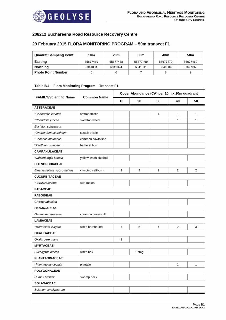
208212 Euchareena Road Resource Recovery Centre 29 February 2015 FLORA MONITORING PROGRAM – 50m transect F1
Quadrat Sampling Point 10m 20m 30m 40m 50m
Easting 55677469 55677468 55677469 55677470 55677469
Northing 6341034 6341024 6341011 6341004 6340997
Photo Point Number 5 6 7 8 9
Table B.1 – Flora Monitoring Program – Transect F1
FAMILY/Scientific Name Common Name Cover Abundance (CA) per 10m x 10m quadrant
10 20 30 40 50
ASTERACEAE
*Carthamus lanatus saffron thistle 1 1 1
*Chondrilla juncea skeleton weed 1 1
Euchiton sphaericus
*Onopordum acanthium scotch thistle
*Sonchus oleraceus common sowthistle
*Xanthium spinosum bathurst burr
CAMPANULACEAE
Wahlenbergia luteola yellow-wash bluebell
CHENOPODIACEAE
Einadia nutans subsp nutans climbing saltbush 1 2 2 2 2
CUCURBITACEAE
*Citrullus lanatus wild melon
FABACEAE
FABOIDEAE
Glycine tabacina
GERANIACEAE
Geranium retrorsum common cranesbill
LAMIACEAE
*Marrubium vulgare white horehound 7 6 4 2 3
OXALIDACEAE
Oxalis perennans 1
MYRTACEAE
Eucalyptus albens white box 1 stag
PLANTAGINACEAE
*Plantago lanceolata plantain 1 1
POLYGONACEAE
Rumex brownii swamp dock
SOLANACEAE
Solanum amblymerum
PAGE B1 208212_REP_001A_2015.DOCX

FLORA AND ABORIGINAL HERITAGE MONITORING EUCHAREENA ROAD RESOURCE RECOVERY CENTRE
ORANGE CITY COUNCIL
Table B.1 – Flora Monitoring Program – Transect F1
FAMILY/Scientific Name Common Name Cover Abundance (CA) per 10m x 10m quadrant
10 20 30 40 50
LOMANDRACEAE
Lomandra filiformis subsp. filiformis wattle mat-rush 1 2 1
POACEAE
*Lolium rigidum wimmera ryegrass 2
*Hordeum leporinum barley grass 1 1
Aristida ramosa purple wiregrass 1
Austrostipa bigeniculata rare spear-grass 2 2
Austrostipa scabra rough spear-grass 1 1
Bothriochloa macra red-leg grass 1 1
Bromus arenarius sand brome
Chloris truncata windmill grass 1 1 1 1
Deyeuxia quadriseta reed bent-grass 1 1
Elymus scaber wheatgrass 1
Microlaena stipoides weeping grass 1
C/A Cover Abundance (Modified Braun Blanquet) 1: <5% cover and few individuals 2: <5% cover and many individuals 3: 5-25% cover 4: 25% - 50% 5: 50% - 75% 6: 75% - 100% *Introduced species
PAGE B2 208212_REP_001A_2015.DOCX

FLORA AND ABORIGINAL HERITAGE MONITORING EUCHAREENA ROAD RESOURCE RECOVERY CENTRE
ORANGE CITY COUNCIL
29 February 2015 FLORA MONITORING PROGRAM – 50m transect F2
Quadrat Sampling Point 10m 20m 30m 40m 50m
Easting 55677967 55677963 55677961 55677953 55677949
Northing 6341489 6341479 6341470 6341461 6341451
Photo Point Number 10 11 12 13 14
Table B.2 – Flora Monitoring Program – Transect F2
FAMILY/Scientific Name Common Name Cover Abundance (CA) per 10m x 10m quadrant
10 20 30 40 50
ASTERACEAE
*Carthamus lanatus saffron thistle 1 1 1 1 1
*Chondrilla juncea skeleton weed 1 2 1 2 1
*Hypericum perforatum st john’s wort 1
*Lactuca serriola prickly lettuce 1
*Taraxacum officinale dandelion 1 1
CHENOPODIACEAE
Einadia nutans subsp nutans climbing saltbush 1 1
GERANIACEAE
Geranium retrorsum common cranesbill
OXALIDACEAE
Oxalis perennans 1
POACEAE
*Lolium rigidum wimmera ryegrass 1 1 1 2 1
Rytidosperma caespitosa common wallaby grass 2 2 1 2 1
Rytidosperma fulvum wallaby grass 1 1 1
Rytidosperma pilosum velvet wallaby-grass 1 1 1 1
Rytidosperma richardsonii straw wallaby grass 2 1 4 1
Austrostipa bigeniculata rare spear-grass 1 1 1
Austrostipa nodosa 1
*Avena fatua wild oats 1
Bothriochloa macra red-leg grass 2 2 1 1 2
Bromus diandrus great brome 1
*Bromus hordeaceus soft brome 2
Phalaris aquatica phalaris 2 2 1 2 3
Oxalis perennans Grassland wood sorrel 1 1
*Dactylis glomerulata cocksfoot 1
*Eleusine tristachya crabgrass
Elymus scaber wheatgrass 1 1
Panicum effusum hairy panic 1 1 1
*Setaria parviflora 2 3 3 2 2
C/A Cover Abundance (Modified Braun Blanquet) 1: <5% cover and few individuals 2: <5% cover and many individuals 3: 5-25% cover 4: 25% - 50% 5: 50% - 75% 6: 75% - 100% *Introduced species
PAGE B3 208212_REP_001A_2015.DOCX

Appendix C LANDSCAPE AND REHABILITATION
TRANSECT FIELD SHEETS

FLORA AND ABORIGINAL HERITAGE MONITORING EUCHAREENA ROAD RESOURCE RECOVERY CENTRE
ORANGE CITY COUNCIL
29 February 2015 FLORA MONITORING PROGRAM – 50m transect L1
Quadrat Sampling Point 10m 20m 30m 40m 50m
Easting 55678401 55678394 55678390 55678382 55678380
Northing 6340590 6340584 6340575 6340567 6340558
Photo Point Number 15 16 17 18 19 Note: GPS co-ordinates amended to site location; Feb 2014 (DL).
Table C.3 - Flora Monitoring Program – Transect L1
10m 20m 30m 40m 50m
Total alive plantings 2 2 3 0 3
Total No plantings 28 23 28 28 24
Success Rate (%) 8 9 11 0 12
Initial 5m Planting Arrangement on site (refer to Figure C)
Initial row spacing (metres) <1 <1 <1 <1 <1
Initial tree spacing (metres) <1 <1 <1 <1 <1
Weed species - Bromus hordeaceus *Carthamus lanatus *Sonchus oleraceus *Hordeum leporinum *Lolium rigidum *Medicago polymorpha *Setaria parviflora *Chondrilla juncea
Weed species Cover Abundance 5 2 3 2 1
Comments The initial 5m of the 70m strip has been planted at a greater density than the rest of the strip as stipulated in the revised methodologies CMP (October 2013). Soil preparation restricted to weed removal with native grasses to remain in situ to retain soil moisture and prevent erosion. The remaining 75m width of the landscaped area will be revegetated as per Appendix F of the CMP. These initial strip plantings have been heavily impacted by seasonal conditions, kangaroo damage and low maintenance
C/A Cover Abundance (Modified Braun Blanquet) 1: <5% cover and few individuals 2: <5% cover and many individuals 3: 5-25% cover 4: 25% - 50% 5: 50% - 75% 6: 75% - 100% *Introduced species 29 February 2015 FLORA MONITORING PROGRAM – 50m transect B1
Quadrat Sampling Point 10m 20m 30m 40m 50m
Easting 55678029 55678019 55678009 55678999 55678989
Northing 6341523 6341525 6341526 6341528 6341530
Photo Point Number 20 na na na 21 na: not applicable until rehabilitation has begun on the bund area. Further photo points will be included once rehabilitation works have commenced at transect B1. A field sheet will be compiled when planting has commenced at bund number 1.
PAGE C1 208212_REP_001A_2015.DOCX

Appendix D OFFICE OF ENVIRONMENT AND
HERITAGE MONITORING REPORT

MONITORING REPORT 2015 Description of work undertaken Source of funding and amount Date completed
Flora and Aboriginal Heritage Monitoring Program of the Euchareena Road Resource Recovery Centre Orange City Council
2014/15 financial year; Activity Total: $4,001.45
Ongoing. (Annual monitoring program)
FIRE HISTORY Date of fire Area burnt
(% of c.a./approx ha) Reason (hazard red./wild)
Intensity (low/medium/high)
History not identifiable. No fire history from past 10 years. 2 isolated and relocated trees burnt as a result of lightning strike.
VISITATION Average No. of Visitors per year Purpose of Visitation Visitation effects Strategies to overcome effects
Visitation to rehabilitation site restricted to monitoring, management staff and neighbouring landholders.
Scheduled water and flora monitoring, Dust monitoring, land management, stock management
Most access is restricted to existing tracks and fire-breaks. Low impact on existing vegetation and communities.
COMMUNITY CONSULTATION AND INPUT INTO DECISION MAKING Type of Involvement Numbers involved Outcomes No community involvement in the past year

PHOTO-MONITORING Vegetation
Community Current condition Benchmark comparison, changes or trends (evidence of natural
regeneration) Threats/issues
Monitoring point 1 Plot R1 Flora Monitoring Point
Derived Grassland, prior pasture
Poor Total removal of grazing since inception of the Resource Recovery Centre. Access tracks are lightly disused and well vegetated. Slashing of perimeter fire protection boundaries undertaken once in last 12 months. Initial high infestation of agricultural weed species, slowly becoming displaced by robust and prolific grass species. (Dominated by pasture associated species). Grass tussocks and tufts becoming well established. Noticeable decline in broad-leaf weed species however thistle still remain in numbers.
Overgrazing if grazing management is reintroduced to grassland areas. Poorly managed spraying/ slashing.
Monitoring point 2 Plot R2 Flora Monitoring Point
Derived Grassland, prior cropping and pastureland. Future revegetation area.
Poor Total removal of grazing since inception of the Resource Recovery Centre. Access tracks are now disused and barely visible. Slashing of perimeter tracks and access to C2 piezometer has occurred once in last 12 months. Agricultural weed species (particularly broad-leaf species), slowly becoming displaced by robust and prolific grass species. (Dominated by pasture associated species). High traffic and grazing by kangaroos across flats.
Overgrazing if grazing management is reintroduced to grassland areas. Poorly managed spraying/ slashing. Hot/ wild-fire impact. Impact on future revegetation areas by increased populations of grey kangaroo on recruitment of native species.
Monitoring point 3 Plot C1 Flora Monitoring Point
Open box woodland remnant
Moderate Total removal of grazing since inception of the Resource Recovery Centre. Partial infestation by robust agricultural weeds. (i.e. Marrubium vulgare). Infestation by Marrubium vulgare is not spreading and becoming more clumped with low recruitment of the species. Favourable establishment of native grass species with good tuft and tussock formation.
Wild-fire impact. Illegal timber collection Defoliation by scarab beetle Poor grazing management leading to impact upon recruitment and spread of weed species). Impact by increased populations of grey kangaroo on recruitment of native species.
Monitoring point 4 Plot C2 Flora Monitoring Point
Open box woodland (Internode between derived grassland and woodland)
Poor to Moderate Total removal of grazing since inception of the Resource Recovery Centre. Infestation by Marrubium vulgare is not spreading and becoming more clumped with low recruitment of the species. Favourable establishment of native grass species and seed-set by the same. Occasional natural recruitment of young eucalypts in the immediate area of Monitoring Point 4.
Wild-fire impact. Illegal timber collection Defoliation by scarab beetle Poor grazing management leading to impact upon recruitment and spread of weed species). Impact by increased populations of grey kangaroo on recruitment of native species.

Vegetation Community
Current condition Benchmark comparison, changes or trends (evidence of natural regeneration)
Threats/issues
Monitoring points 5 to 9 Transect F1
Open box woodland remnant
Moderate Total removal of grazing since inception of the Resource Recovery Centre. Continued infestation by robust agricultural weeds. (I.e. Marrubium vulgare on old stock camps amongst trees). Grassy understorey impacted by large populations of Kangaroos using the area for camps and shelter. Some favourable establishment of native grass species and seed-set by the same. Tussock formation reduced due to browsing by kangaroo population.
Wild-fire impact. Illegal timber collection Defoliation by scarab beetle Poor grazing management leading to impact upon recruitment and spread of weed species). Impact by increased populations of grey kangaroo on recruitment of native species and possible spread of weed species.
Monitoring Points 10 to 14 Transect F2
Derived Grassland, prior cropping and pastureland. Future revegetation area.
Poor Total removal of grazing since inception of the Resource Recovery Centre. Access tracks are now disused and barely visible. Slashing of perimeter tracks and access to C2 piezometer has occurred once in last 12 months. Agricultural weed species (particularly broad-leaf species), slowly becoming displaced by robust and prolific grass species. (Dominated by pasture associated species). High traffic and grazing by kangaroos across flats.
Overgrazing if grazing management is reintroduced to grassland areas. Poorly managed spraying/ slashing. Hot/ wild-fire impact. Impact on future revegetation areas by increased populations of grey kangaroo on recruitment of native species.
Monitoring Points 15 to 19 Transect L1
Derived Grassland, prior cropping and pastureland. Future revegetation area.
Poor Total removal of grazing since inception of the Resource Recovery Centre. Site preparation and initial tree planting was carried out in December 2012. Slight reduction in diversity of agricultural weed species. Few surviving young trees slow to emerge from grassy dominated groundcover. Interference to the few young trees by Kangaroos.
Poor grazing management and grazing of unfenced tree lots. Poorly managed and maintained replanting areas. Damage to tube stock by kangaroos Loss of young trees by fire.
Monitoring Point 20 Transect B1
Derived grassland. Perimeter Bund Future revegetation area.
Poor Total removal of grazing since inception of the Resource Recovery Centre. Subject area subject to complete vegetation removal and landscaping. No seeding or tubestock planted as of March 2015. Subject site vegetated by very tall and dense pasture-associated species and robust grass species.
Continued dominance by weed species on disturbed site. Poor grazing management leading to impact upon recruitment and spread of weed species). Impact on future revegetation areas by increased populations of grey kangaroo on recruitment of native species.
Monitoring Point 21 Aboriginal Scarred Tree
N/A – Scarred Tree
Moderate to good Little to no change. Slight diggings at base of tree by echidnas. No detrimental damage to site.
Dimensions and physical attributes of tree and scar recorded annually. Fire threat, potential for heavy stock damage (Cattle), insect attack, storm damage, undermining by rabbits

CONSERVATION VALUES Conservation Values noted in Agreement
and its significance Current condition
Current and emerging threats Level (severe, high, moderate or low) and extent (throughout, widespread, scattered or localised) of threats
New findings; any other relevant information.
Native vegetation
Box woodland and derived Grassland Mainly Poor/ Moderate. Some areas; moderate
Grazing management, Weed ingression, Dieback, Declining regeneration. Kangaroo populations increasing beyond locally sustainable number.
Low to moderate threat. Scattered to Localised
Local population of Kangaroos steadily increasing. Resident populations over winter average 80 to 100 individuals. Summer population counted to 180 to 200 individuals.
EECs White Box, Yellow Box, Blakely’s Red Gum EEC
Mainly Poor/ Moderate. Some areas; moderate
Wild-fire, Grazing management, poor recruitment and revegetation. Kangaroo populations increasing beyond locally sustainable number.
Low threat, Scattered to localised
Threatened fauna Brown Tree-creeper, Koala, Eastern Bentwing Bat, Superb Parrot
Moderate Loss of hollows due to storm events and tree die-back. Competition for nesting and foraging resources by pest species.
Low to Moderate threat. Widespread
Superb Parrots regularly recorded on site. Resident and transient population. Birds observed nesting on site (Oct 2014).
Threatened flora None listed in Agreement
Aboriginal Cultural Heritage
Scarred Tree Moderate Wild-fire, Dieback Low threat Localised
Aboriginal Heritage Information System; Molong ST1, Site ID 44-1-0080
Research/ education
None listed
Other

MANAGEMENT ISSUES Describe the Issue
(short description of current extent of impacts, new sightings and any other relevant information
Description of planning and implementation of control measures being and to be undertaken, and duration
Weeds (where applicable, infestation can be given as a % of total vegetation).
Agriculturally associated weed infestation as a whole across the flora monitoring sites has remained relatively stable in areas of high prior disturbances. Weed species diversity and dominance throughout established woodland areas has declined A strong influence by Marrubium vulgare and Carthamus lanatus is present across the monitoring sites and it is expected that these species will continue decline with minimised grazing and ground disturbance influences. In areas where kangaroo activity is elevated, these species will remain dominant. Noxious weed species are monitored, controlled and have not been observed increasing or introduced.
Managed grazing or shock grazing (short heavy grazing episode) may be introduced late winter or early spring 2015. Weed control on access roads, tracks and firebreaks outside the ERRRC compound needs to be addressed to minimise weed spread by vehicles. Slashed access tracks need to be maintained to reduce the spread of weeds while accessing piezos and dust gauges. Identification of new weeds within or at edge of compound. Management of same. Continued monitoring of problem weed areas, especially post-grazing applications. Recommended establishment of test plot for the application of herbicide on Horehound infested area to investigate suitable reduction of this weed species within the EEC.
Pest Animals - Feral - Domestic - Native
Feral: Resident rabbit populations are low on site with no new warrens or refuges identified. Some activity has been recorded on the rocky hill adjacent to the scarred tree site. Fox populations are generally reflective of prey availability on site. Occasional access to food waste and rubbish. Access holes have been dug under the perimeter fence. Two new den sites have been identified; one adjacent to Transect F1 and one located below the dam wall east of the compound. Kangaroos have persisted in large numbers (190 + individuals) during the summer period of 2014-2015. Transient populations have moved on to the site and remained on site due to sheltered grassland forage and available watering points. Winter resident populations have increased in this last reporting period.
Rabbit populations (post-winter 2014) should be monitored and refuges or warrens removed. Fox numbers should be monitored and any increased activity within the ERRRC compound addressed. Kangaroo populations have become more permanent on site with high resident numbers recorded throughout summer and into the winter months. Joeys are also common throughout the population, indicating that resident kangaroos are breeding on site. The rate of population increase has risen from approximately 30 individuals (recorded pre summer 2013). Kangaroo numbers should be monitored during spring and summer 2015. Heightened populations are likely to significantly reduce tree woodland recruitment, promote weed-spread, lower grassland establishment in weed infested areas, damaged fence infrastructure and have a high impact on planted tree lots. Control of increasing kangaroo populations on site needs to be investigated.

Describe the Issue (short description of current extent of impacts, new sightings and any other relevant information
Description of planning and implementation of control measures being and to be undertaken, and duration
Natural regeneration Seasonal conditions have improved over the past 12 months with a higher biomass present across many of the study plots. This ground material acts as a mulch, returns nutrients to the ground and inhibits broad-leaf weed germination. In areas where weed ingression is broad and strongly dominates the ground-cover, inadequate seed bank and stabilisation of groundcover (post full-time grazing) have not permitted regeneration of many woodland species. Grassland species have seeded well resulting in increasing equalisation of derived grassland species across the site (replacing purely pasture related species and weeds). Tussocks and native species grass tufts are developing and establishing well in many areas. Natural recruitment is occurring throughout woodland communities with young saplings becoming evident above grass height. Isolated young saplings are often subject to damage by kangaroos.
Planned grazing management regime should be considered 2015.
Fire Management Vegetation loadings (veg-biomass) across the broad open regeneration areas continue to increase. Tracks and compound perimeter fence road remains overgrown.
Implement and maintain a system of firebreaks around the enclosure and perimeter of the site. Do not let access perimeter roads and tracks to become overgrown with weed species. Tramping of tall grasses across the open grassy areas of the site by managed grazing regime (late winter-early spring) may assist in reducing wild-fire risk by summer.
Revegetation Natural recruitment by eucalypts is occurring on site. Low establishment success within the existing tree-lots have been caused by a range of factors including; poor planting conditions, low management and maintenance during the initial establishment period, impact by Kangaroos, weed infestation/ competition and seasonal conditions.
Future plantings to be planned and managed so that monitoring/ maintenance during establishment period is allocated. Response time to issues effecting survival needs to be quick. Kangaroo impact on any future unfenced tree-lots is expected to be high.
Threatened species; endangered ecological communities etc
Lack of ongoing and updated recording response of fauna to rehabilitation and remnant management areas.
Any sightings of threatened species should be recorded. Broad-community reference photo-points should be established so that a record of factors such as recruitment, die-back, storm damage etc, can be collated.
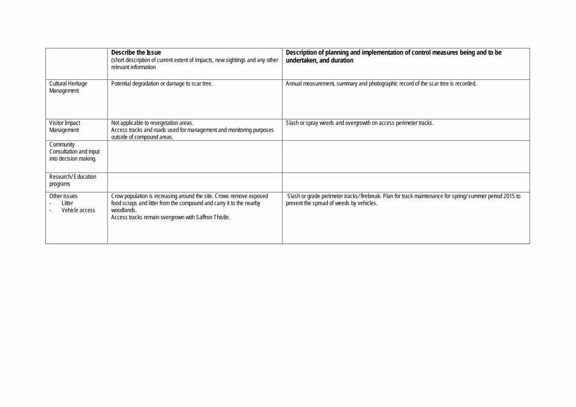
Describe the Issue (short description of current extent of impacts, new sightings and any other relevant information
Description of planning and implementation of control measures being and to be undertaken, and duration
Cultural Heritage Management
Potential degradation or damage to scar tree. Annual measurement, summary and photographic record of the scar tree is recorded.
Visitor Impact Management
Not applicable to revegetation areas. Access tracks and roads used for management and monitoring purposes outside of compound areas.
Slash or spray weeds and overgrowth on access perimeter tracks.
Community Consultation and input into decision making.
Research/ Education programs
Other issues - Litter - Vehicle access
Crow population is increasing around the site. Crows remove exposed food scraps and litter from the compound and carry it to the nearby woodlands. Access tracks remain overgrown with Saffron Thistle.
Slash or grade perimeter tracks/ firebreak. Plan for track maintenance for spring/ summer period 2015 to prevent the spread of weeds by vehicles.

WORKPLAN TO ADDRESS MANAGEMENT ISSUES (in priority order) Action to be completed or ongoing action (discuss on site and where necessary confirm details later)
Cost and possible funding sources
Completion Date
Responsibility
Revegetation (refer Conservation Management Plan)
ongoing OCC
Weed Control ongoing OCC
Pest Species Control ongoing OCC