Embed Size (px)
Citation preview
Flood Management in the
Avon-Otakaro Corridor: Short-term &
Long-term Options
Sarah Long, Emma Fleetwood, Sarah Hayman, Paul Sutherland,
James Lentjes & Ellis Evens
Flood Management in the Avon-Otakaro Corridor
2
Table of Contents:
1. Executive Summary…………………………………….
2. Introduction………………………………………………..
3. Literature Review………………………………………..
4. Methodology……………………………………………….
4.1 Interviews
4.2 Surveys
4.3 GPS & GIS
5. Results & Discussion…………………………………….
5.1 LiDAR Data
5.2 Existing Methods
5.3 Surveys
5.4 Interviews
5.5 Proposed Mitigation Measures
5.6 Spillways
5.7 Stopbanks
5.8 Management Retreat
5.9 Wetlands
5.10 Other Methods
6. Limitations……………………………………………………..
7. Conclusions…………………………………………………….
8. Acknowledgements………………………………………..
9. References……………………………………………………..
10. Appendix……………………………………………………….
10.1 Survey Questions
Flood Management in the Avon-Otakaro Corridor
3
1. Executive Summary
1.1 Research Question
What is the most suitable and viable mitigation option in the lower Avon Otakaro
Corridor?
1.2 Aims and Objectives
What are the current mitigation methods in place?
What are residents’ opinions on current and future flood protection options?
What mitigation methods are the Christchurch City Council looking into?
What areas are most at risk of flooding?
Why is the area so susceptible to flooding following the earthquake?
What is the most suitable method or combination of methods to best protect the
area against flooding in both the short and long-term?
1.3 Context for the Research
Following the September 4th and February 22nd earthquakes the land has subsided
and left the area vulnerable to flooding.
Current mitigation methods only include stopbanks (either temporary or permanent)
and sandbags which are rundown.
1.4 Summary of Method
Literature reviews aided in the decision on what specific mitigation options should
be explored and what methodology should be considered.
Discussion with our community partner Hugo Kristinsson and using information
gathered from our literature reviews, enabled us to decide upon three types of data
collection; surveys, interviews and physical data collection.
Surveys were completed through interviewing residents directly affected by flooding
and were done in person and through email; this ruled out any bias information and
allowed for spontaneous conversation.
Interviews of key Christchurch decision makers Tony Oliver, Graham Harrington and
Greg Whyte gave slight insight into what current research is being done.

Flood Management in the Avon-Otakaro Corridor
4
Physical data was collected in the form of GPS and LiDAR data. These were used to
show the current mitigation measures, red zoned areas, flood risk areas, as well as to
create maps showing pre and post-earthquake land subsidence.
1.5 Key Findings
Sand bags are rundown and in desperate need of replacement (Figure 6 & 7),
majority of stopbanks are temporary (Figure 8 & 9), there are some well-built
stopbanks which have implemented walk ways and vegetation (Figure 10 & 11).
Residents most preferred options include stopbanks, spillways, vegetation and
wetlands.
Christchurch City Council is mainly looking into stopbanks, but this information is not
readily available to the public, as it is “sensitive information”. Other options
discussed were management retreat and flooding the estuary during high flow
periods.
The most suitable option found in terms of cost, feasibility, and public preference
was to include a combination of stopbanks, spillways and wetlands. These options
would be immediate short term mitigation methods. And to explore the option of
management retreat as a long term mitigation method to combat future rises in sea-
level.
1.6 Limitations
Major issues came from the lack of information readily available to the public from
Christchurch City Council.
Time was an obvious limitation, due to the size of the study area and how complex
the issue is.
Due to the Christchurch city’s current rebuild costs the mitigation methods are
limited to low cost and low importance.
1.7 Suggestions for Further Research
Due to predicted sea level rise, there is a definite need to further explore the option
of management retreat. Looking into what subsidies will be in place for movers, and
to try to gage a feel of residents’ resilience to move.

Flood Management in the Avon-Otakaro Corridor
5
2. Introduction
On September 2010 a 7.1 magnitude earthquake struck the New Zealand city of
Christchurch and initiated a series of major earthquakes until June 2011. This increase in
seismic activity has had severe impacts on the built and natural environment throughout
Christchurch, particularly in the eastern suburbs. A natural impact is the subsidence of land,
caused by the sinking of silts and sands; which makes up the majority of Christchurch’s
underlying sediment. The subsidence has had a direct contribution to the increased flood
hazard in the Avon River corridor. This includes areas such as Bexley that have now been
deemed as red zones. Our research was set out to discover what conditions currently existed
in our selected area, what residents opinions were on current and future options, as well as
aiming to gage what direction the Christchurch City Council (CCC) are looking to take
towards solving this problem. Following from this our group used a wide array of data
collection techniques in order to find the most appropriate mitigation option, the details and
results of which are outlined in this report.
3. Literature Review
3.1 Current Flood Management
Literature has shown that there are many mitigation measures that can be implemented to
lessen flooding impacts. However, it is about determining the most viable and suitable
option for the Avon corridor that would have the most significant effect in reducing the
flood risk. Depending on the financial situation of the inflicted area will determine what type
of management scheme will be used. The majority of urban flood defences comprise of soft
measures or hard engineering structures (van Ree et al., 2011). Where there is no money
available, this is when no active intervention is used as engineering options are too
expensive (Ledoux et al., 2004). Management retreat is considered a soft measure and is
only feasible when all other methods have been exhausted and considered when public or
private assets are unsustainable (Ledoux et al., 2004). Therefore flood management
techniques used is dependent on the society involved and the economics (Ledoux et al.,
2004).
3.2 Resilience in Flood Management

Flood Management in the Avon-Otakaro Corridor
6
Reducing flooding risk and increasing resilience is a key theme that arises from literature.
Since urban areas are more developed they are confined to less space, therefore flood
defences and barriers tend to work better in open spaces (Zevenbergen et al., 2011). Urban
areas also have a large amount of impervious surface which increases run-off and the flood
extent as less infiltration can occur (Jing, 2010). Zevenbergen et al. (2007) discussed a
holistic approach is needed for flood management as there are many factors to consider
such as flood levels, land elevation and water velocity. Cost is also a key factor as particular
areas with different inundation levels experience different types of flooding effects
(Zevenbergen et al., 2007).
3.3 Community Participation
Community involvement and awareness is a major factor towards flood management, as
people have to live with the mitigation methods chosen. Correia et al. (1998) and Ledoux et
al. (2004) discuss the importance of communication and involving the public in the planning
and implementation of management techniques. This was one particular issue that our
community partner highlighted as information and awareness on the issue is severely lacked
in the case study area. Our community partner was concerned that residents were not being
informed enough from the CCC. Therefore it was decided by the group to find current plans
and research being done by the CCC for flood management.
Geographic Information Systems (GIS) is one technique that can be used to illustrate and
model flood management options and their interaction with humans (Correia et al., 1998).
Producing GIS maps could be a possible method that was used for the project to inform the
public on the flood risk (Correia et al., 1998).
Involvement from other stakeholders such as local, regional and central government as well
as wildlife and recreational groups (e.g. walking groups) is also important as all opinions
must be taken into consideration (Correia et al., 1998).

Flood Management in the Avon-Otakaro Corridor
7
Figure 1: Case study area of the lower Avon River (Christchurch City Council, 2013).
4. Methodology
The yellow box on Figure 1 outlines the case study area in the Avon-Otakaro corridor where
we collected our information. This area was chosen as it has the largest flood risk from sea
level rise, rainfall and tidal flooding. Although some of this area has been red zoned due to
the earthquakes, there are still areas that are inhabitable and are exposed to the flood risk
(as shown on Figure 2 and 3).
After developing our research question it became clear that we would require both
qualitative and quantitative data. We decided on three methods of data collection which
included surveying, interviewing and physical data collection.

Flood Management in the Avon-Otakaro Corridor
8
Figure 2: Flood risk of a 0.5 metre rise in sea level (Christchurch City Council, 2013).
Figure 3: Red zone land of the lower Avon (Christchurch Earthquake Recovery Authority, 2012).
4.1 Qualitative
The first step was to develop a survey to address our issue of community involvement.
When surveying, we chose random sampling so that we got a good assortment of people
with different perceptions and backgrounds and targeted people situated within the flood
zone. This was to make sure there was no bias result and that the people being directly
affected were surveyed. Surveys were done either face-to-face or through email which our
community partner distributed to his contacts in the area.
We also set up interviews with key Christchurch decision makers who were involved with
the flood issue. Firstly we spoke with Tony Oliver, a principal hazard analyst from
Environment Canterbury. We also interviewed Greg Whyte, a principal engineer from DHI
Group that runs computer configurations for the CCC using GIS software. Lastly, we
interviewed Graham Harrington, a senior surface water planner for the CCC. These

Flood Management in the Avon-Otakaro Corridor
9
interviews were used to learn more about flood mitigation options and any new plans that
were being considered for the Avon corridor.
4.2 Quantitative
We collected GPS data which we analyzed and produced maps using ArcGIS. LiDAR data was
obtained from the University of Canterbury’s Geography Department and programmed into
ArcMap where maps were produced. From the LiDAR data particular grids had to be
selected that represented our case study area. Using ArcMap we were able to Mosaic those
grids together and make a clean image that would show the elevation pre and post-
earthquake. These elevation maps were then used to determine subsidence and suitable
locations for proposed mitigation measures.
5. Results & Discussion
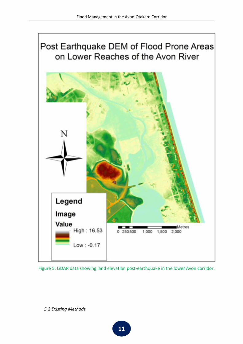
5.1 LiDAR Data
The past few years of seismic activity has caused significant land subsidence in the area and
some areas have been red zoned because of this. Pre-earthquake LiDAR data (Figure 4) was
used as a reliable source to reflect the difference in land elevation compared to post-
earthquake LiDAR data (Figure 5). Both pre and post-earthquake LiDAR data show how land
has subsided in areas such as Bexley and areas adjacent to the Avon River. These areas have
subsided up to 1.0 metres, meaning that the land is now a similar height to the river. This is
fine on a day to day basis but when a sea level rise of up to 0.5 metres and a one in a
hundred year flood is considered, the seriousness of the situation becomes apparent.

Flood Management in the Avon-Otakaro Corridor
10
Figure 4: LiDAR data showing land elevation pre-earthquake in the lower Avon corridor.
Flood Management in the Avon-Otakaro Corridor
11
Figure 5: LiDAR data showing land elevation post-earthquake in the lower Avon corridor.
5.2 Existing Methods

Flood Management in the Avon-Otakaro Corridor
12
Figure 7: Sandbag location in relation to
Avon River (Google Maps 2013).
Figure 6: Photograph of sandbags on
Owles Terrace.
Figure 8: Photograph of temporary
stopbank. Figure 9: Stopbank location in relation to
Avon River Source (Google Maps 2013).
There are various types of stopbanks currently in place, these range in size and suitability
from worn out stop banks to earthquake proof gravel banks.
The most derelict are seen along Owles Terrace (Figure 6), which have run their course and
are in need of immediate replacement.
The majority of the current stopbanks are made up from concrete barriers in filled with
gravel (Figure 8); they run for the majority of New Brighton road. These stopbanks are
effective but only a temporary mitigation source due to their unattractive appearance.
Along Kibblewhite Street there are earthquake proof effective stopbanks, these consist of
compacted gravel and are planted to increase stability (Figure 10). They also have walk and

Flood Management in the Avon-Otakaro Corridor
13
Figure 10: Photograph of permanent
stopbank. Figure 11: Location of stopbanks in
relation to Avon River (Google Maps,
2013).
bike paths running on top of them, making them more appealing and functional to the
public.
5.3 Surveys

Flood Management in the Avon-Otakaro Corridor
14
Figure 12: Map of locations where surveys were taken in the lower Avon Otakaro
corridor.
0 500 1,000 1,500 2,000250Metres

Flood Management in the Avon-Otakaro Corridor
15
Figure 13: Percentage of people who are informed of the flood risk by the city
council as answered by surveys.
We collected surveys from 20 different households with their locations shown on Figure 12.
The questions that were answered by residents in the case study area are in Appendix 10.1.
Our survey results showed that there was only one street (Kibblewhite Street) who had
received a pamphlet that obtained information from the CCC about the current flood
hazard. This is why 10% of households thought the council was informing them on the
current flood hazard, as shown on Figure 13. Whilst 65% of households had not heard
anything and 25% of households did not even know there was a flood hazard. This was
interesting because areas where people were experiencing flooding were receiving no
information from the council. However, people that were not experiencing flooding were
receiving pamphlets from the council about the flood risk. This suggests that the council
needs to better plan the areas that require flood information based on the areas flooding
experiences.

Flood Management in the Avon-Otakaro Corridor
16
Figure 14: Percentage of people who think current flood mitigation is effective as
answered by surveys.
Figure 15: Percentage of people whose property floods as answered by surveys.
There were 80% of households that thought current flood mitigation was effective but only
in the short term, as shown on Figure 14. This is due to some parts of the stopbanks failing
and currently being held up by sand bags or concrete barriers, suggesting that the CCC need
to implement more permanent flood mitigation.

Flood Management in the Avon-Otakaro Corridor
17
Figure 16: Percentage of people’s thoughts on management retreat as answered
by surveys
Surprisingly, no one had flooding on their property, but 65 % of households had experienced
street/path flooding, as shown on Figure 15. This caused difficulty for children that had to
walk to school, which made parents quite concerned for their children’s safety. Therefore
this increases the need for more effective mitigation measures to be installed.
Although many people did not know a significant amount about management retreat it was
surprising to find that 85% of households accepted the concept of it, as shown on Figure 16.
Our surveys found that once we had explained the concept of management retreat, people
were willing to move if it came down to it. From this result it can be suggested that
management retreat has a significant community backing which makes it significantly easier
to proceed with. This is explained further in 5.8 Management Retreat.
5.4 Interviews
From our first interview with Tony Oliver we were provided with a report he wrote called
‘Issues and Options for managing the Avon River floodplain’. This report contained various
flood mitigation options that could be implemented in the Avon river corridor. Although this
report was written before the earthquakes occurred it still provided relevant options for the
area. This information was then used to further develop our ideas about the most viable

Flood Management in the Avon-Otakaro Corridor
18
flood mitigation techniques. Stopbanks was the main option highlighted in the report, which
are discussed further in 5.7 Stopbanks.
While interviewing Greg Whyte we were able to obtain a better visualization of the flood
risk in the Avon corridor through the use of GIS. The main point we took from this interview
was that not one mitigation measure will be able to mitigate all flood types. This allowed us
to understand that a combination of mitigation techniques are needed to constrain the
flood extent. Greg also suggested the idea of spillways and noted the issue of the land being
high in elevation compared to the river so would therefore require significant excavation.
This issue is discussed further in 5.6 Spillways.
Obtaining information from the CCC was also crucial as they are key decision makers in
Christchurch. Although Graham Harrington could not provide great detail on the work the
council is doing due to it not being disclosed information, he assured us the council is
looking into stopbanks and potentially management retreat. Questions were asked about
whether stopbank height was considered in comparison to sea level rise. This allowed for
insight into whether the council was looking into long-term mitigation strategies. We also
asked if the council had considered management retreat in the New Brighton area. It had
briefly been considered and they have said there is more information in which they need to
learn before taking further steps.
5.5 Proposed Mitigation Measures

Flood Management in the Avon-Otakaro Corridor
19
Figure 17 shows the proposed mitigation measures that were produced using the digitize
tool in ArcMap. This map was completed based on the research we had found and the
mitigation measures that were believed to be the most appropriate for the area. The blue
0 500 1,000 1,500 2,000250Metres
Figure 17: Proposed mitigation measures for the lower Avon Otakaro corridor produced in ArcMap.

Flood Management in the Avon-Otakaro Corridor
20
lines indicate where new stopbanks would be implemented and are located around the
edge of the red zone. These stopbanks are placed here because when the river is in flood,
the water is able to flow over the banks and into the wetlands. The wetlands (green areas)
will allow water to infiltrate and reduce run-off, which will reduce flood extents. Since
Bexley was severely damaged in the earthquakes and this area has now been deemed
uninhabitable and uneconomic to build on, this area would be restored back to wetlands.
The orange area represents spillways that will be used to store water during flood events.
5.6 Spillways
Spillways or flood storage ponds are a common stormwater management approach in
controlling the level of river flow. It works on the principle of storing a portion of the water
coming from the upstream and allowing a limited flow to the downstream of the catchment.
In this way, the flow rate is restricted to stay within the capacity of the downstream river
banks (Drainage Services Department, 2012). This is achieved through having closable gates
both into and out of the storage area. Gates are opened during a high flow event and then
releasing water when levels have lowered.
5.7 Stopbanks
Stopbanks are a suitable mitigation measure as they are one of the most effective methods
for flood protection (Christchurch City Council, 1997). They provide protection from multiple
flood types including sea-level rise, tidal flooding and river flooding (Christchurch City
Council, 1997). There is also significant prior knowledge of stopbanks as they are currently
used along the Avon River and many other rivers around New Zealand and the World. This
includes the Waihou River in Waikato where stopbanks protect hundreds of acres of prime
dairy land from flooding every year (Waikato District Council, personal communication,
September 24, 2013). There is also a strong community backing for stopbanks as they are
prominent features in the environment and can be used for recreational activities such as
walking and cycle paths. These recreational activities can be used to draw people back into
the area and create an identity that has been lost since the earthquakes.
Flood Management in the Avon-Otakaro Corridor
21
Like all other options, stopbanks also have limitations. This includes the cost of upkeep and
construction (Christchurch City Council, 1997). The cost of a stopbanks would be an
estimated $50 – 75 per metre and this figure can also vary depending on the source of
material and how far it has to be moved from (Fulton Hogan, personal communication,
September 27, 2013). However, by using recycled material close to the site can lessen the
costs of stopbanks. But even though there is this expense, our interview with the CCC has
indicated that stopbanks will be implemented as a main mitigation measure on the Avon
River.
Some residents were also concerned that stopbanks could reduce their view of the river and
estuary, particularly when this is the main reason why they brought the property. They
noted that the construction of stopbanks needs to be efficient and must maintain the
natural look of the area. This could be done by planting vegetation on them to restore the
natural environment of the Avon River.
The council believes that the stopbanks are at the most suitable level at the moment and
have no intention on raising the height. Current stopbanks implemented are 11 metres in
height and 1 metre off the ground. This suggests that they would not be effective if a sea
level rise of 0.5 metres was to occur. Therefore we have proposed stopbanks as a short-
term option for the Avon corridor.
5.8 Management Retreat
Management retreat is defined by relocation through setback limits and causes prevention
of further development (Alexander et al., 2012; Cooper, 2003). It requires a community to
gradually withdraw investment in public assets in affected areas and actively pursue
withdrawal of settlement in some areas over time. This is an option that the New Brighton
area could implement in the long term as the issue of sea level rise increases with climate
change. The Kapiti Coast in the North Island, New Zealand is one example of where this
mitigation option is beginning to occur. Although there has been no current action, the
Kapiti Coast District Council has included it in their proposed district plan (Kapiti Coast

Flood Management in the Avon-Otakaro Corridor
22
District Council, 2012). Management retreat is a suitable option as moving people out of the
affected area reduces the risk to the community and allows for long-term planning and
management.
However there are still limitations to this option. Although whilst carrying out our surveys
we were able to further explain the option to some of the community, there was still a
definite lack of understanding and awareness. Community awareness needs to be
addressed and the public need to be educated for acceptance to be gained on management
retreat (Alexander et al., 2012). This could be done through the use of workshops and
meetings to ensure understanding is achieved.
Subsidizing people that need to move from the area is also an issue. Since there has already
been a significant amount of money issued to the rebuild, the CCC and insurance companies
may not be as willing to compensate people’s homes. Set back limits also need to be
carefully considered as it requires a significant amount of scientific knowledge which can
also be expensive (Alexander et al., 2012).
Since people have lived in these areas for many years, there comes the issue of attachment
to homes and neighborhoods (Agyeman et al., 2009). It needs to be emphasized that this is
people's livelihood that is being interrupted so it is important that their feelings and
thoughts are considered especially when relocating them to a different area as their
happiness, safety and security is important.
5.9 Wetlands
Wetlands are another flood mitigation measure we have proposed for the lower Avon
corridor. Wetlands have recreational value with the use of walkways and cycleways that can
attract people back into the area. As discussed on The Press (2012) online forum the public
are behind wetland restoration as they are important for native wildlife and plants and
contribute to improving water quality.
However there are also downfalls to wetlands as they do not provide habitat security during
flood events. Therefore wildlife and plants are disturbed, limiting their populations.
Wetlands are also difficult to restore as they have been drained and altered to
Flood Management in the Avon-Otakaro Corridor
23
accommodate human needs (Zedler, 2000). Adequate timing, frequency, amplitude and
duration of high water levels need to be maintained to support biodiversity and
functionality of wetlands (Zedler, 2000). Therefore wetlands are a suitable option for the
lower Avon but would require a significant scientific knowledge and research on the existing
wetland conditions.
5.10 Other Methods
The following includes a brief summary of other methods that we researched but did not
think were appropriate for the case study area due to their economic viability.
Raising Houses & Floatable Houses
Raised and floatable houses are both similar concepts as they require foundations to be
raised above flood water levels. Raising houses involves lifting the lowest level above the
expected flood level by using piles or columns to elevate the foundation (Zevenbergen et al.,
2011). Floatable houses are structures which are built on hollow concrete pontoons or
polystyrene blocks that become buoyant when floods occur (Zevenbergen et al., 2011).
Since these methods require significant costs and are extremely expensive, this option is not
economically viable for Christchurch.
Dredging
We also looked into dredging, a method that is carried out underwater to move bottom
sediments off of rivers. Dredging makes the river deeper and therefore allows the river to
hold more water. This option was very expensive and would have to be repeated often. It
also creates disturbances to ecosystems, possible contamination and release of toxic
chemicals from bottom lying sediments (Xing et al., 2006).
5. Limitations
Management Retreat
Management retreat is one of our long term options. When talking to Graham Harrington
from the CCC he said that management retreat had only briefly been considered and that
there is more information in which they need to learn before taking further steps. Meaning

Flood Management in the Avon-Otakaro Corridor
24
that it is an idea that has come up, but no one is willing to do the research needed, making it
harder for us to find information.
Short-term and Long-term Definitions
The terms "short term" and "long term" are both hard to define and are dependent on the
issue and situation. Due to there being ongoing seismic activity and disruption to
Christchurch it is hard to determine when the flood mitigation measures will be
implemented. In our current situation "short term" is defined as occurring during the next 5
to 7 years. Whilst in the long term we can expect the measures to take place in up to 10
years or more as these measures require more planning and management. There is also the
question of how fast climate change will occur and when Christchurch will encounter sea
level rise. This can only be determined by further research and modeling to define the
impact of sea level rise on the area.
Time
An important constraint for our study was time as we only had 12-13 weeks to carry out our
research. This has caused us to restrict the case study area to only the lower Avon corridor
instead of the entire river. Time restraints also lessened the amount of people surveyed
which limited the information and opinions received from the community. A larger time
frame would have allowed for a more in depth analysis including cost of spillways, location
of setback limits for management retreat and a design layout for wetlands.
Survey Restrictions
We wanted to get the public involved to get their opinions and thoughts of the current flood
hazard, and see what they thought needed to be done. To begin with the area we wanted to
survey was half red zone, meaning no one was living there or they were not willing to
complete the survey. We did manage to get 20 completed surveys in the end though the
methods of door knocking and emailing. But it was a lot more time consuming than we first
thought.
7. Conclusion

Flood Management in the Avon-Otakaro Corridor
25
Following the series of earthquakes which have struck Christchurch since September 4th
2010 the Avon Otakaro corridor has undergone a great deal of subsidence and has now
become more susceptible to flooding. Through qualitative and quantitative data collection
in the form of surveys, interviews and physical data collection we have decided upon the
most appropriate mitigation options. This includes two stages, short and long term; initially
in the short term there will need to be immediate remediation of current stopbanks along
with the introduction of spillways into selected red zoned areas. Following these initial
techniques, wetlands and management retreat could be implemented in response to both
predicted sea level and ground water level rise. It needs to be understood that these
mitigation measures require significant planning and management. Involvement and
awareness from all stakeholders is also highly important for flood mitigation measure to be
effective.
8. Acknowledgements

Flood Management in the Avon-Otakaro Corridor
26
We would like to thank the following people for their support and help during the duration
of this project:
Hugo Kristinsson, Bryan Jenkins and the Avon-Otakaro Network.
Peyman Zawar-Reza our supervisor.
Justin Harrison, John Thyne, Gregory Breetzke & Paul Bealing for helping with the
GPS and GIS work.
Graham Harrington, Tony Oliver & Greg Whyte for allowing us to interview them.
The residents in the flood zone that allowed us to survey them and obtain useful
information.
Word Count: 1,495
9. References

Flood Management in the Avon-Otakaro Corridor
27
Agyeman, J., Devine-Wright, P., & Prange, J. (2009). Close to the edge, down by the river?
Joining up managed retreat and place attachment in a climate changed world.
Environment and Planning, 41(3), 509-513.
Alexander, K.S., Ryan, A., & Measham, T.G. (2012). Managed Retreat of Coastal
Communities: Understanding Responses to Projected Sea Level Rise. Journal of
Environmental Planning and Management, 50(4), 409-433.
Christchurch City Council. (1997). Issues and Options for managing the Avon River
floodplain. Retrieved from Tony Oliver, Environment Canterbury.
Christchurch City Council. (2013). Avon River Modelled Flood Depth: Map 5. Retrieved from
http://www.ccc.govt.nz/
Christchurch Earthquake Recovery Authority. (2012). Land Status Map. Retrieved from
http://cera.govt.nz/maps/land-status
Cooper, N.J. (2003). The use of ‘managed retreat’ in coastal engineering. Proceedings of the
ICE – Engineering Sustainability, 156(2), 101-110.
Correia, F.N., Fordham, M., Saraiva, M., & Bernardo, F. (1998). Flood Hazard Assessment
and Management: Interface with the Public. Water Resources Management, 12,
209-227. Retrieved from SpringerLink database.
Drainage Services Departments (2012). Flood service ponds. Retrieved from
http://www.dsd.gov.hk/EN/HTML/242.html
Google Maps. (2013). [Avon River, Christchurch] [Street Map]. Retrieved from
https://maps.google.co.nz/maps?q=avon+river&hl=en&ll=-
43.514852,172.725377&spn=0.017646,0.042272&sll=-
40.799894,175.310128&sspn=37.550906,86.572266&t=h&hq=avon+river&z=15
Jing, Z. (2010). GIS Based Urban Flood Inundation Modelling. GCIS '10 Proceedings of the
2010 Second WRI Global Congress on Intelligent Systems, 2, 140-143.
Kapiti Coast District Council. (2012). Proposed Kapiti Coast District Plan 2012: Summary
Guide. Retrieved from
http://www.kapiticoast.govt.nz/Documents/Downloads/District-Plan-
Review/Proposed-District-
Plan/Summary_Guide_to_the_Proposed_District_Plan_2012.pdf

Flood Management in the Avon-Otakaro Corridor
28
Ledoux, L., Cornell, S., O’Riordan, T., Harvey, R., & Banyard, L. (2004). Towards
sustainable flood and coastal management: identifying drivers of, and obstacles to,
managed realignment. Land Use Policy, 22 (2005), 129-144. Retrieved from
ScienceDirect database.
The Press. (2012). Christchurch Earthquakes 2011: Zone Life, Your Ideas. Retrieved from
http://firstfourships.co.nz/rzProject/zonelife-ideas.php
van Ree, M.A., Heilemann, K., Morris, M.W., Royet, P., & Zevenbergen, C. (2011)
FloodProBE: technologies for improved safety of the built environment in relation to
flood events. Environment Science & Policy, 14, 874-883.
Xing, Y. N., Ruan, X. H., & Zhao, Z. H. (2006). Effects of depth of sediment dredging in urban
rivers on release of nitrogen and phosphorus. Journal of Hohai University (Natural
Sciences), 4, 005.
Zedler, J.B. (2000). Progress in wetland restoration ecology. Trends in Ecology & Evolution,
15(10), 402 - 407. Retrieved from ScienceDirect.
Zevenbergen, C., Cashman, A., Evelpidou, Pasche, E., Garvin, S., & Ashley, R. (2011).
Flood proofing the urban fabric. Urban Flood Management (pp. 205-225). London:
Taylor & Francis Group.
Zevenbergen,C., Gersonius,B., Puyan,N., Van Herk,S., (2007) Economic Feasibility Study Of
Flood Proofing Domestic Dwellings. Advances in Urban Flood Management, 13, 299-
319.
10. Appendix
10.1 Survey Questions

Flood Management in the Avon-Otakaro Corridor
29
1. What is your current street address?
2. How long have you been living in the address above?
3. Are you a business owner or household owner?
4. Are you aware of the current flood hazard in your area?
5. Does your property flood, if so how often pre earthquake?
6. Extent of flooding? (Where does the water accumulate)
7. Post earthquake?
8. Extent of flooding? (Where does the water accumulate)
9. Personal experiences, of flooding within your household?
10. Are you willing to spend money on flood mitigation measure on your own property or business?
11. If you are tenants, is your landlord willing to spend money on flood mitigation measure?
12. Do you think the council is doing everything they can to inform you of the current flood situation?
13. Is the council, doing enough to manage the current flood hazard?
14. If not, what do you think should be changed and enforced?
15. How effective do you think the existing flood mitigation methods are? (Stopbanks, sand bags etc)
16. What would be your preferred flood hazard management, mitigation measures? 17. Rank these in ascending order of your preferred preferences
Spillways

Flood Management in the Avon-Otakaro Corridor
30
Stock banks
Vegetation
Manage retreat
Raising houses
Dredging
Other
18. How much do you know about Management retreat?
19. Would you be willing to move house?