Embed Size (px)
Citation preview

City of Alexandria, Virginia
Flood Insurance Rate MapChanges
Informational Meeting – For PropertyOwners Entering the Floodplain
Durant CenterFebruary 23, 2011

City of Alexandria, Virginia
Introductions
• City of Alexandria– Transportation and Environmental Services
Department– Planning and Zoning Department
• Virginia Department of Conservation andRecreation
• Federal Emergency Management Agency(FEMA)
City of Alexandria, Virginia
Background Information
• City participates in the National FloodInsurance Program (NFIP)
• As part of the NFIP, FEMA has updatedthe Flood Insurance Rate Maps (FIRMs)and published a Flood Insurance Study(FIS) for Alexandria
• FIRM and FIS will be effective as of June16, 2011

City of Alexandria, Virginia
Purpose of Tonight’s Meeting
• Who: Property owners now entering thefloodplain (approximately 300 propertiescitywide)
• Agenda:– Discussion of FEMA program– Summary of changes to new flood maps– City construction permit requirements– Insurance requirements and grandfathering– Removal of properties from the floodplain

City of Alexandria, Virginia
Why is this important?

City of Alexandria, Virginia
Why is this important?
• Flooding causes the most declareddisasters and damages the mostinfrastructure
• Flood insurance is the best and mostreliable response and recovery method toflooding
• The NFIP and its mitigation actions reduceand prevent future flood losses

City of Alexandria, Virginia
National Flood InsuranceProgram (NFIP) Overview
• Administered by FEMA• City’s participation allows residents and
business owners to purchase floodinsurance
• City enforces FEMA permitting regulationsvia its Zoning Ordinance (Section 6-300)
• Requires all property owners in the 100-year floodplain with federally-regulatedmortgages purchase flood insurance

City of Alexandria, Virginia
Summary of FIRM Changes
• Part of FEMA’s 2003 Map ModernizationProgram to update and digitize existingflood maps
• Floodplains delineated based on City 2-foot contours
• New vertical datum (NAVD88)• New analysis for Cameron Run watershed

City of Alexandria, Virginia

City of Alexandria, Virginia
Old Town/PotomacRiver
– Mapping based onCity 2-foot contourdata (no new study)
– Base flood elevation =10 feet NAVD88
– Floodplain widthdecreases overall
City of Alexandria, Virginia
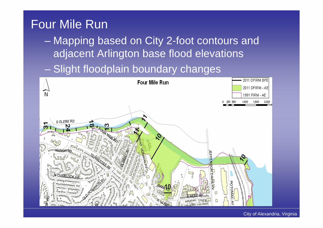
Four Mile Run– Mapping based on City 2-foot contours and
adjacent Arlington base flood elevations– Slight floodplain boundary changes

City of Alexandria, Virginia
Cameron Run Watershed– Restudied and resurveyed by USACE in 2006– Floodplain increases in a couple of areas;
decreases overall

City of Alexandria, Virginia
Rosemont/Hooff’s Run– Not previously
mapped– Underground culvert
has limited capacityand overtopped duringJune 2006 event
New floodplainarea
Limit ofprevious study
City of Alexandria, Virginia
Permitting in the Floodplain
• New construction and substantialimprovement to a structure (not parcel)subject to additional requirementsspecified in City floodplain ordinance
• Substantial improvement = anyreconstruction or improvement to astructure, the cost of which equals orexceeds 50% of the market value of thestructure
City of Alexandria, Virginia
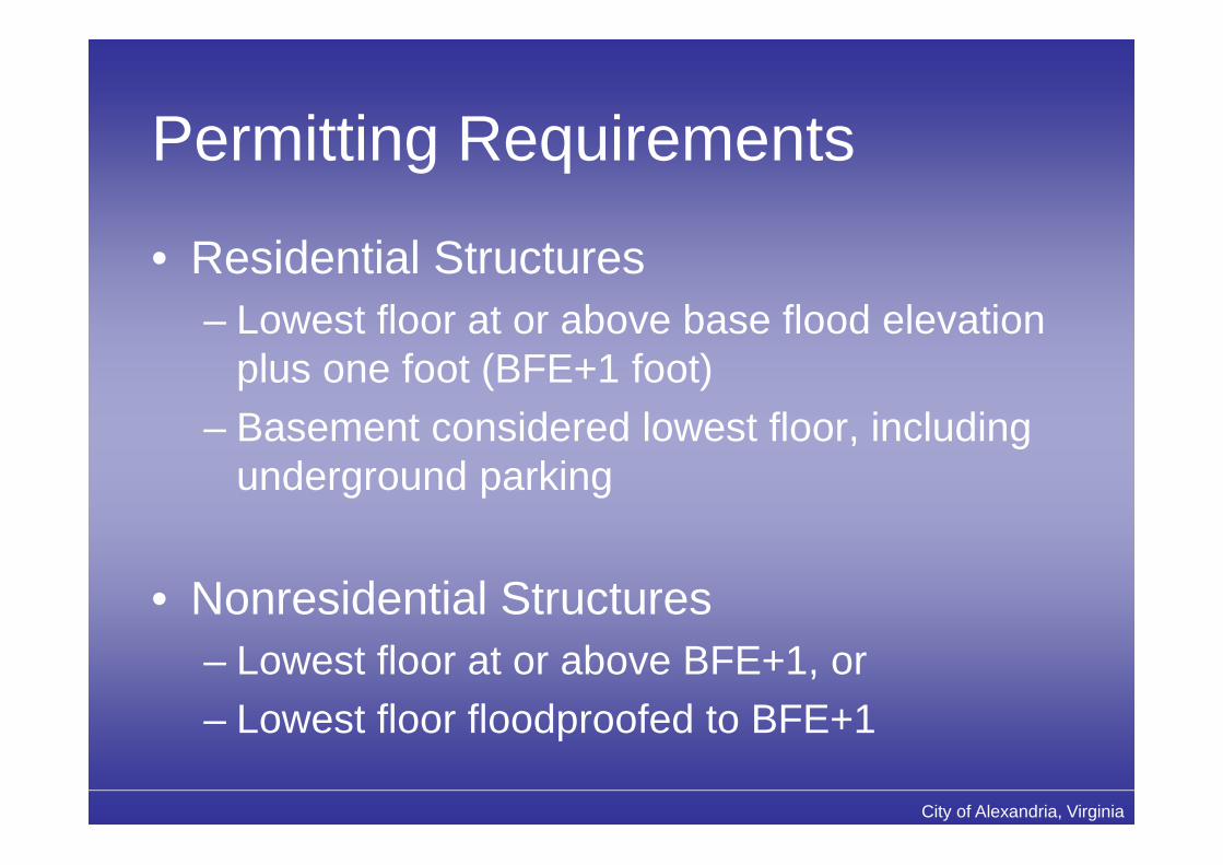
Permitting Requirements
• Residential Structures– Lowest floor at or above base flood elevation
plus one foot (BFE+1 foot)– Basement considered lowest floor, including
underground parking
• Nonresidential Structures– Lowest floor at or above BFE+1, or– Lowest floor floodproofed to BFE+1

City of Alexandria, Virginia
Permitting Requirements
• Mixed-use Structures– Mix of residential and nonresidential uses– May be floodproofed in some cases, but all
habitable living spaces must meet BFE+1requirement
– City evaluating appropriate use on a citywidebasis

City of Alexandria, Virginia
Infill Regulations• Threshold/1st floor required in line w/ existing• Regulation change to allow BFE+1 w/o SUP

City of Alexandria, Virginia
Rosemont NR Historic District
• Renovationspermitted to“contributinghistoric structures”for work thatmaintains historiccharacter/integrity

City of Alexandria, Virginia
Ordinance Update
• FEMA requires adoption of updatedfloodplain ordinance before June 16, 2011
• Incorporates date of new map• No significant regulatory changes• Pilot phase of mixed-use provision
City of Alexandria, Virginia
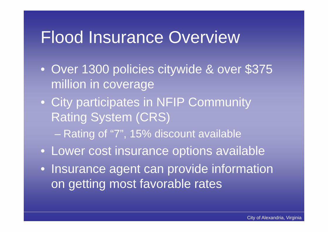
Flood Insurance Overview
• Over 1300 policies citywide & over $375million in coverage
• City participates in NFIP CommunityRating System (CRS)– Rating of “7”, 15% discount available
• Lower cost insurance options available• Insurance agent can provide information
on getting most favorable rates

City of Alexandria, Virginia
Preferred Risk Policy (PRP)• PRP is a program to help reduce the
financial burden to property ownersentering the SFHA
• Property owners pay significantly reducedrates for 2 policy years following the maprevision date
• Buildings must meet loss historyrequirements
• More information atwww.floodsmart.gov/PRPextension

City of Alexandria, Virginia
Floodplain Mapping Isn’t Perfect
• Based on best available data• Structure in the floodplain may be above
base flood elevation (BFE)• FEMA has established procedures to
review and remove an individual structurefrom the floodplain
• If requirements met, FEMA will issue letterstating structure is out of the floodplain
• Can be done through LOMA process
City of Alexandria, Virginia
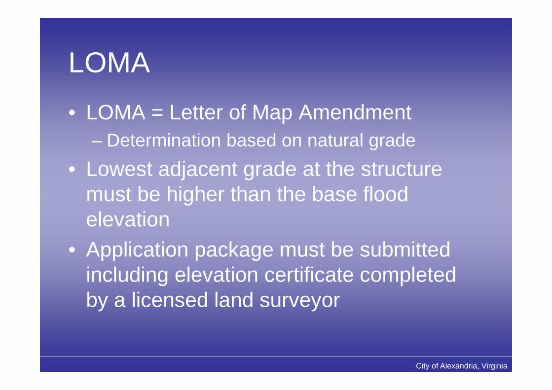
LOMA
• LOMA = Letter of Map Amendment– Determination based on natural grade
• Lowest adjacent grade at the structuremust be higher than the base floodelevation
• Application package must be submittedincluding elevation certificate completedby a licensed land surveyor
City of Alexandria, Virginia
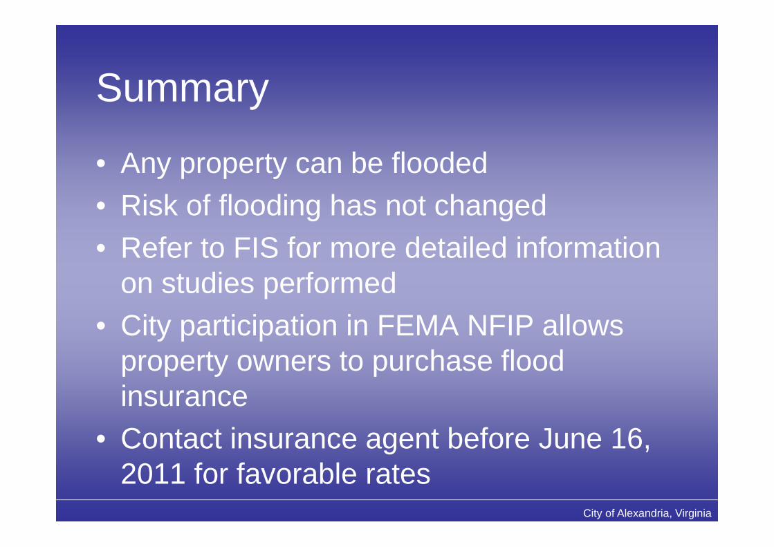
Summary
• Any property can be flooded• Risk of flooding has not changed• Refer to FIS for more detailed information
on studies performed• City participation in FEMA NFIP allows
property owners to purchase floodinsurance
• Contact insurance agent before June 16,2011 for favorable rates
City of Alexandria, Virginia
For More Information
FEMAMap Assistance Center
877-FEMA-MAPFloodSmart.gov
City of AlexandriaEngineering & Design Division
703-746-4045Alexandriava.gov/FloodMap

City of Alexandria, Virginia
Questions?


![Flood Map Modernization Flood Map Modernization Mapping the Risk Editorial Board Meeting [date] V123005 [COMMUNITY NAME] FLOOD MAP MODERNIZATION](https://img.dokumen.tips/doc/110x75/56649ebb5503460f94bc3787/flood-map-modernization-flood-map-modernization-mapping-the-risk-editorial.jpg)