Embed Size (px)
Citation preview

9th International Conference on Urban Drainage Modelling Belgrade 2012
1
Flood hazard assessment in the Raval District of Barcelona using a 1D/2D coupled model Beniamino Russo1 , David Suñer2, Marc Velasco3, Slobodan Djordjević4
1 Clavegueram de Barcelona S. A. (CLABSA), Spain, [email protected]; Engineering Technical College of La Almunia (EUPLA - University of Zaragoza), Spain, [email protected] 2 Clavegueram de Barcelona S. A. (CLABSA), Spain, [email protected] 3 Centro Tecnológico del Agua (CETaqua – Agbar Group), Spain, [email protected] 4 University of Exeter, United Kingdom, [email protected]
ABSTRACT CORFU is an interdisciplinary project funded by the European Commission in the framework of the 7th FP with the aim to improve the practice of urban flood risk management. In this context, eight case studies regarding European and Asian cities are being developed with the main objective to analyze and improve their resilience to flood impacts. This paper presents the results of a 1D/2D coupled model simulating surface and sewer flows in the Barcelona case study. The model covers 44 km2 of the city land involving 238 km of sewers. The model was developed in order to assess the flood hazard in the Raval District, historically affected by flooding problems during heavy storm events. Special attention was paid to the hydraulic characterization of the inlet systems (representing the interface between surface and underground flows), through experimental expressions used to estimate the runoff amounts effectively introduced into the sewers in case of storms. 2D unstructured mesh was created on the basis of a detailed DTM with a resolution of 1 m2 and a precision of 15 cm in terms of elevation. Hydrological and physical differences between pervious and impervious areas were taken into account in the 2D analyzed domain.
KEYWORDS 1D/2D coupled modelling, Flood hazard, Urban drainage
1 INTRODUCTION The EU 7th Framework Programme CORFU (Collaborative Research on Flood Resilience in Urban Areas) is an interdisciplinary project funded by the European Commission with the aim to improve the practice of urban flood risk management. In this context, eight case studies regarding cites in Europe and Asia are being developed with the main objective to analyze and improve their resilience with respect to flood impacts.
2
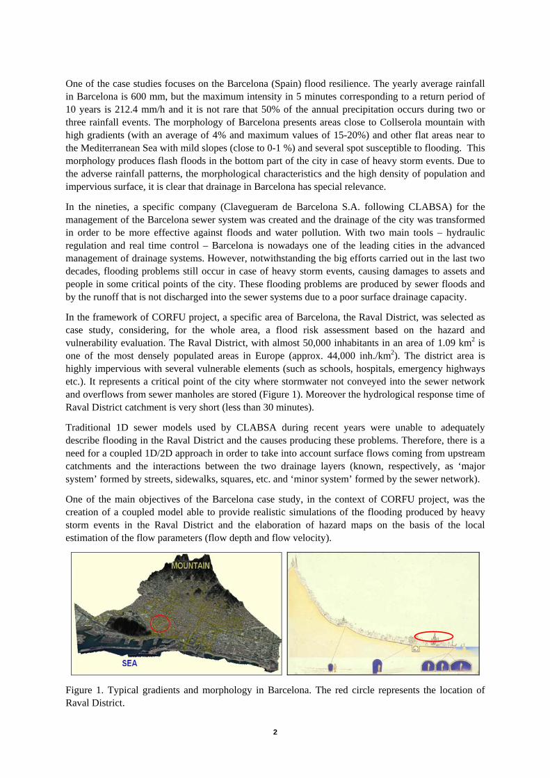
One of the case studies focuses on the Barcelona (Spain) flood resilience. The yearly average rainfall in Barcelona is 600 mm, but the maximum intensity in 5 minutes corresponding to a return period of 10 years is 212.4 mm/h and it is not rare that 50% of the annual precipitation occurs during two or three rainfall events. The morphology of Barcelona presents areas close to Collserola mountain with high gradients (with an average of 4% and maximum values of 15-20%) and other flat areas near to the Mediterranean Sea with mild slopes (close to 0-1 %) and several spot susceptible to flooding. This morphology produces flash floods in the bottom part of the city in case of heavy storm events. Due to the adverse rainfall patterns, the morphological characteristics and the high density of population and impervious surface, it is clear that drainage in Barcelona has special relevance.
In the nineties, a specific company (Clavegueram de Barcelona S.A. following CLABSA) for the management of the Barcelona sewer system was created and the drainage of the city was transformed in order to be more effective against floods and water pollution. With two main tools – hydraulic regulation and real time control – Barcelona is nowadays one of the leading cities in the advanced management of drainage systems. However, notwithstanding the big efforts carried out in the last two decades, flooding problems still occur in case of heavy storm events, causing damages to assets and people in some critical points of the city. These flooding problems are produced by sewer floods and by the runoff that is not discharged into the sewer systems due to a poor surface drainage capacity.
In the framework of CORFU project, a specific area of Barcelona, the Raval District, was selected as case study, considering, for the whole area, a flood risk assessment based on the hazard and vulnerability evaluation. The Raval District, with almost 50,000 inhabitants in an area of 1.09 km2 is one of the most densely populated areas in Europe (approx. 44,000 inh./km2). The district area is highly impervious with several vulnerable elements (such as schools, hospitals, emergency highways etc.). It represents a critical point of the city where stormwater not conveyed into the sewer network and overflows from sewer manholes are stored (Figure 1). Moreover the hydrological response time of Raval District catchment is very short (less than 30 minutes).
Traditional 1D sewer models used by CLABSA during recent years were unable to adequately describe flooding in the Raval District and the causes producing these problems. Therefore, there is a need for a coupled 1D/2D approach in order to take into account surface flows coming from upstream catchments and the interactions between the two drainage layers (known, respectively, as ‘major system’ formed by streets, sidewalks, squares, etc. and ‘minor system’ formed by the sewer network).
One of the main objectives of the Barcelona case study, in the context of CORFU project, was the creation of a coupled model able to provide realistic simulations of the flooding produced by heavy storm events in the Raval District and the elaboration of hazard maps on the basis of the local estimation of the flow parameters (flow depth and flow velocity).
Figure 1. Typical gradients and morphology in Barcelona. The red circle represents the location of Raval District.

3
2 METHODOLOGY
2.1 General aspects for the creation of a coupled 1D/2D urban model
Recently several authors published interesting papers treating the need of coupled approaches (modelling of the surface and sewer flows at the same time) to represent adequately urban flooding caused by sewer overflows (Phillips et al., 2005; Lipeme Kouuyi et al., 2008; Obermayer et al., 2010; Leandro et al., 2009) and carry out a realistic flood risk assessment (Kandory and Willems, 2008). Currently, a 1D/2D coupled model (2D for the analysis of the hydraulic behaviour of the ‘major system’ formed by streets, sidewalks, squares, etc. and 1D for the analysis of the ‘minor system’ formed by the sewer network), represents a powerful tool to describe, in a very realistic way, the hydraulic behaviour of urban areas suffering flooding problems due to the excess of runoff not conveyed by the drainage networks. However, in order to ensure good and detailed results, it is not sufficient to have a technologically advanced tool for the calculation concerning hydrological and hydraulic processes, but several other aspects must also be carefully considered, such as:
- Detailed topographic data able to reproduce complex urban morphologies
- Methodologies able to take into account flow interchanges between the two layers of drainage (surface and underground layers)
- Rainfall and flow / flow-depths records for the adjustment of the model parameters in the calibration phase and for the results verification
- Time series of the operations carried out by the sewer devices (variable sluices, pumps, etc.)
These aspects were considered for the creation of the 1D/2D coupled model of the Raval District. The software used for the creation of the model was the version 2.5 of Infoworks ICM by Innovyze (2012).
2.2 Topographic data
Urban areas present a very complex topography due to the presence of elements such as buildings, sidewalks, roadways, gutters, walls and banks. When a storm event occurs in our cities, generally, runoff produced in roofs and terraces is directly conveyed to the underground sewer networks, while runoff produced in roadways, parks, squares, etc. circulates over the urban surfaces up to reach the inlet structures of the drainage systems. Moreover, due to relatively low roughness of the surfaces in urban areas, stormwater runoff is characterized by low flow depths (less than 15-20 centimetres) and high flow velocities (up to 3-4 meters per second). In this context, it is crucial to have a detailed Digital Terrain Model (DTM) with high resolution. For this study, a specific DTM model was provided by the Catalan Institute of Cartography. This DTM presents a resolution of 1 m2 obtained by a LIDAR flight with a density of 1.33 points/m2 and a precision of 15 cm in terms of ground elevation.
2.3 Characterization of the hydraulics of surface drainage systems
The need to estimate the hydraulics of the surface drainage structures and to model them through a coupled 1D/2D approach is clear. Moreover the possibility to characterize hydraulically all the connections (manholes and drain inlets) between surface and underground systems allows to improve the estimation of surface and pipe flows during a storm. The consideration, at the same time, of the surface flow and its interaction with sewer flow is commonly known as ‘dual drainage modelling’, with flow components on the surface and underground (Djordjevic et al., 1999) (Figure 2).

4
Figure 2. Interaction of surface and sewer flow (dual drainage concept) (Schmitt et al. 2004).
In order to achieve this objective, the hydraulic performance of the inlets present in the Raval District was analyzed using experimental expressions proposed in a recent methodology by Gómez and Russo (2009; 2011). Specifically, all the inlets located in the Raval District (more than 2600 units and almost 50 types) were classified in main groups represented by 8 inlet type previously studied by Gómez and Russo (2011) (Figure 3). The hydraulic efficiency of these grated inlets was analyzed according to the specific type and several geometric parameters of the location (longitudinal and transverse slopes, gutter section, width of the roadway, etc.). Finally, hydraulic efficiency of each grated inlet was compared to the performance of the Barcelona1 inlet (the top right one in Figure 3) in order to obtain specific weighted efficiency coefficients defined as following:
1Barcelona
iwe E
Ec
i= (1)
where:
cwei is the specific weighted efficiency coefficient for the type grate i (from 1 to 8).
EBarcelona1 is the hydraulic efficiency of the grated inlet Barcelona1 (where efficiency is defined as the ratio between the flow captured by the grated inlet and the flow circulating in the gutter).
Ei is the hydraulic efficiency of the grated inlet type i.
Combining street geometric configurations and the types of grates cwei range varies from 1 to 2.1.
Figure 3. Grated inlet types considered for the flood hazard assessment study in the Raval District. The Barcelona 1 inlet is shown in the top right image (framed in red).
5
Moreover a clogging factor of 50% was uniformly applied to all inlet types and all geometric configurations in order to take into account possible reduction of the hydraulic efficiency due to blockage of grated inlet void areas during storm events (Gómez and Russo, 2012).
2.4 Creation of the 1D/2D coupled model
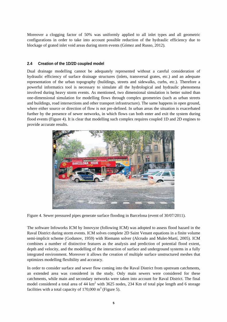
Dual drainage modelling cannot be adequately represented without a careful consideration of hydraulic efficiency of surface drainage structures (inlets, transversal grates, etc.) and an adequate representation of the urban topography (buildings, streets and sidewalks, curbs, etc.). Therefore a powerful informatics tool is necessary to simulate all the hydrological and hydraulic phenomena involved during heavy storm events. As mentioned, two dimensional simulation is better suited than one-dimensional simulation for modelling flows through complex geometries (such as urban streets and buildings, road intersections and other transport infrastructure). The same happens in open ground, where either source or direction of flow is not pre-defined. In urban areas the situation is exacerbated further by the presence of sewer networks, in which flows can both enter and exit the system during flood events (Figure 4). It is clear that modelling such complex requires coupled 1D and 2D engines to provide accurate results.
Figure 4. Sewer pressured pipes generate surface flooding in Barcelona (event of 30/07/2011).
The software Infoworks ICM by Innovyze (following ICM) was adopted to assess flood hazard in the Raval District during storm events. ICM solves complete 2D Saint Venant equations in a finite volume semi-implicit scheme (Godunov, 1959) with Riemann solver (Alcrudo and Mulet-Martí, 2005). ICM combines a number of distinctive features as the analysis and prediction of potential flood extent, depth and velocity, and the modelling of the interaction of surface and underground systems in a fully integrated environment. Moreover it allows the creation of multiple surface unstructured meshes that optimizes modelling flexibility and accuracy.
In order to consider surface and sewer flow coming into the Raval District from upstream catchments, an extended area was considered in the study. Only main sewers were considered for these catchments, while main and secondary networks were taken into account for Raval District. The final model considered a total area of 44 km2 with 3625 nodes, 234 Km of total pipe length and 6 storage facilities with a total capacity of 170,000 m3 (Figure 5).

6
Figure 5. The final model of Barcelona case study. The red circle highlights the high density of pipes and nodes corresponding to the main and secondary networks of the Raval District.
A 2D mesh covered the whole analyzed domain with 403,925 triangles. Parks and other green areas were represented in the same 2D mesh, trough “2D infiltration zones” characterized by their specific hydrological, physical and geometric parameters (Figure 6), while buildings were represented as void areas. Runoff produced in the building areas was directly conveyed into the sewer network in accordance with local practice in Barcelona, where roofs and terraces (approximately corresponding to 50% of the whole analyzed domain) are directly connected to the underground sewers.
Figure 6. Flexible unstructured mesh with triangular cells representing the streets and pervious areas (shown in red) of the city. On the bottom-right corner of the figure, it is possible to see the narrow streets of the Raval District involved in the 2D mesh.
ICM permits inlet hydraulic characterization and the consequent possibility to carry out 1D/2D simulations according to the dual drainage concept previously explained. The inlet effect in the model is to limit the flow rate from the surface into the manhole, or vice versa. This can lead to the situation (as occurs in reality) where there is surface flooding whilst there is available capacity in the below ground system.
7
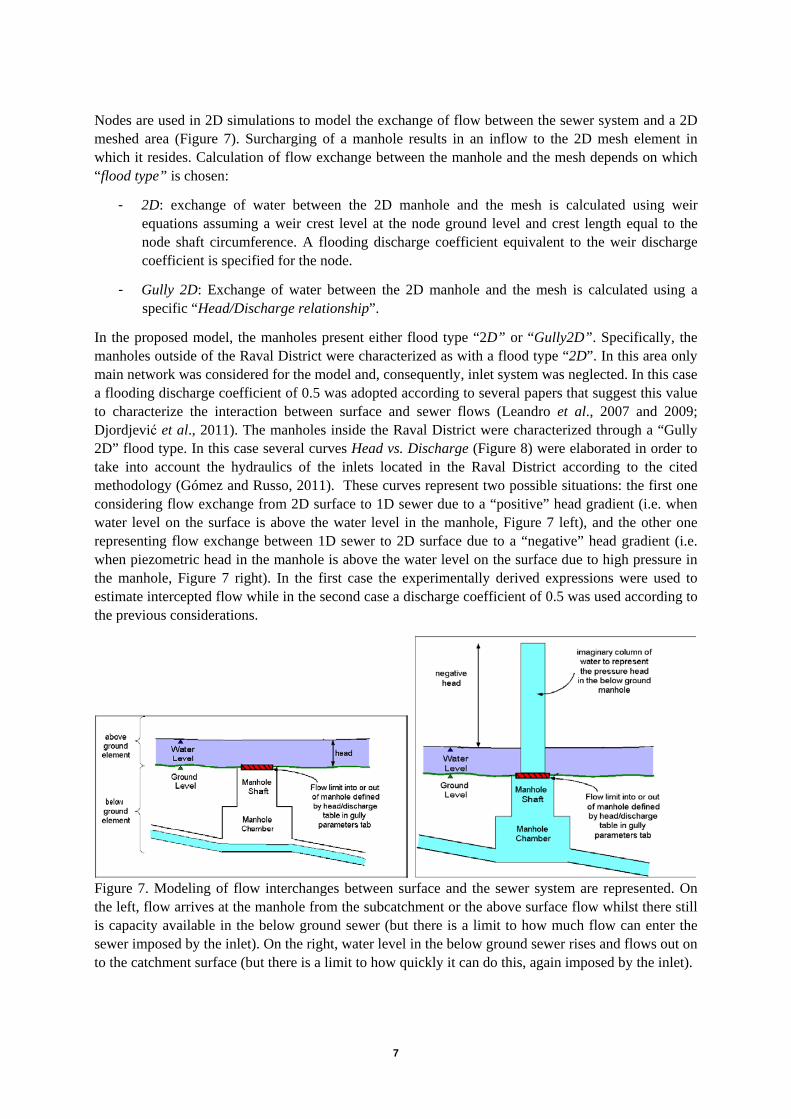
Nodes are used in 2D simulations to model the exchange of flow between the sewer system and a 2D meshed area (Figure 7). Surcharging of a manhole results in an inflow to the 2D mesh element in which it resides. Calculation of flow exchange between the manhole and the mesh depends on which “flood type” is chosen:
- 2D: exchange of water between the 2D manhole and the mesh is calculated using weir equations assuming a weir crest level at the node ground level and crest length equal to the node shaft circumference. A flooding discharge coefficient equivalent to the weir discharge coefficient is specified for the node.
- Gully 2D: Exchange of water between the 2D manhole and the mesh is calculated using a specific “Head/Discharge relationship”.
In the proposed model, the manholes present either flood type “2D” or “Gully2D”. Specifically, the manholes outside of the Raval District were characterized as with a flood type “2D”. In this area only main network was considered for the model and, consequently, inlet system was neglected. In this case a flooding discharge coefficient of 0.5 was adopted according to several papers that suggest this value to characterize the interaction between surface and sewer flows (Leandro et al., 2007 and 2009; Djordjević et al., 2011). The manholes inside the Raval District were characterized through a “Gully 2D” flood type. In this case several curves Head vs. Discharge (Figure 8) were elaborated in order to take into account the hydraulics of the inlets located in the Raval District according to the cited methodology (Gómez and Russo, 2011). These curves represent two possible situations: the first one considering flow exchange from 2D surface to 1D sewer due to a “positive” head gradient (i.e. when water level on the surface is above the water level in the manhole, Figure 7 left), and the other one representing flow exchange between 1D sewer to 2D surface due to a “negative” head gradient (i.e. when piezometric head in the manhole is above the water level on the surface due to high pressure in the manhole, Figure 7 right). In the first case the experimentally derived expressions were used to estimate intercepted flow while in the second case a discharge coefficient of 0.5 was used according to the previous considerations.
Figure 7. Modeling of flow interchanges between surface and the sewer system are represented. On the left, flow arrives at the manhole from the subcatchment or the above surface flow whilst there still is capacity available in the below ground sewer (but there is a limit to how much flow can enter the sewer imposed by the inlet). On the right, water level in the below ground sewer rises and flows out on to the catchment surface (but there is a limit to how quickly it can do this, again imposed by the inlet).

8
Figure 8. Head/Discharge curve for a node with “Gully 2D” flood type to model the flow exchanges between the sewer system and the 2D meshed area.
As mentioned, flow interchanges were simulated through manholes (nodes) although they occur through the inlets too. ICM allows to treat a manhole as a set of inlets defining the “number of equivalent inlets” neq for each Gully2D. neq is a scaling factor used to multiply the discharge values of the Head/Discharge Tables and for this model was calculated using the following equation:
ii
iweeq ncn ⋅= ∑=
8
1 (2)
where:
neq is the integer number of equivalent inlet associated to a Gully2D node
ni is the number of inlet with type i (i=1, …, 8) associated to a Gully2D node.
Head/Discharge Tables for the inlet Barcelona1 were defined for several geometric conditions and were related to each Gully2D node.
In order to determine the number of inlets associated to each Gully2D node, the “microcatchments” were defined as the portion of the surface 2D (containing grated inlets) related to each Gully2D node. These microcatchments were defined generating overland flow paths through a GIS tool (Figure 9).
Figure 9. Overland flow paths and microcatchments in the Raval District.

9
3 RESULTS
3.1 Calibration of the model
CLABSA Exploitation and Maintenance Department provided rainfall data for the calibration of the 1D/2D Raval model. Rainfall data come from the CLABSA rain gauges network containing 24 rain gauges. Finally, 11 rain gauges were selected and their location is shown in Figure 10.
Due to the recent significant changes of the Barcelona sewer system (new infrastructure such as pipes and tanks were built in the past few months and regularly work now), rainfall events in year 2011 were selected. According to literature (DHI, 2002), three storm events were selected for calibration process, while another one was selected for verification. The main characteristics of these events are shown in the Table 1.
Figure 10. Sewer pipes, rain and water level gauges in the 1D/2D model of Barcelona case study.
Table 1. Events selected for calibration and verification of the model
Date event Cumulative rainfall
Maximum rainfall intensity in 20
minutes
Maximum rainfall intensity
in 5 minutes
Function of the event
(mm) (mm/h) (mm/h) 15/03/2011 54.1 69.6 98.4 Calibration 07/06/2011 26.8 24.3 49.2 Calibration 19/07/2011 45.9 95.1 135.6 Calibration 30/07/2011 30.4 105.9 140.4 Verification

10
Flooding reports and 29 water level gauges located in manholes and conduits of the analyzed domain were used for the calibration/verification processes (Figure 10). Specifically, flow depth series calculated by the model was compared to flow depth series recorded by the water level gauges. In addition, flooding parameters provided by the model (perimeter of flooded areas, flow depths of the overland flow, etc.) were compared to observed data collected in the emergency reports of policemen, firemen and affected population during the selected storm events. In Figure 11 it is possible to observe the very good agreement between the historically flooded areas of the Raval and the results, in terms of flow depths map, of the coupled model for Barcelona design storm with a return period of 10 years.
Figure 11. On the left, the pink area represents the frequently flooded areas inside the analyzed domain. On the right, hazard map in terms of flow depths achieved through the 1D/2D coupled model for a storm with a return period of 10 years is shown.
Moreover, Figure 12 shows the hazard map in terms of flow depth (cells exceeding 10 cm of flow depths are represented in red color) and flooding in Sant Pau Street during the last storm event of 30/07/2011. Specifically, it is possible to observe that 1D/2D coupled model is able to reproduce correctly surface flow depth evolution (up to 50 cm approximately) in this critical street of Raval District.
Figure 12. On the left, hazard maps based on flow depths is shown. On the right, the effects of the last flooding (30/07/2011) in Sant Pau Street are shown.
11
3.2 Sensitivity analysis
1D/2D coupled models in urban areas represent an innovative technique to analyze the hydraulic behaviour of critical streets during heavy storm events. Available literature does not yet provide extensive reference on the importance and influence of all parameters involved in hydrological and hydraulic processes. In this framework, it is important to cite the results about a sensitivity analysis concerning the routing parameters in a 2D domain carried out by the Department of Civil & Structural Engineering of the Sheffield University. In this study Infoworks CS was used and results showed the extent of the flooded area is relatively insensitive to mesh density, surface roughness and whether buildings are considered. The modelling of buildings has however been shown to have a significant effect on flood depths, as has surface roughness to a lesser extent. Mesh density is important in refining flood paths and would have more significance where the floodplain is less well defined (Shepherd et al., 2011). For Barcelona case study, sensitivity analysis was carried out in order to study the influence of Manning roughness (range from 0.013 to 0.020 s/m1/3) on the surface flow. Results do not show strong dependency of the surface flood extension to this parameter.
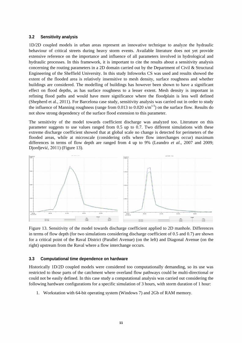
The sensitivity of the model towards coefficient discharge was analyzed too. Literature on this parameter suggests to use values ranged from 0.5 up to 0.7. Two different simulations with these extreme discharge coefficient showed that at global scale no change is detected for perimeters of the flooded areas, while at microscale (considering cells where flow interchanges occur) maximum differences in terms of flow depth are ranged from 4 up to 9% (Leandro et al., 2007 and 2009; Djordjević, 2011) (Figure 13).
Figure 13. Sensitivity of the model towards discharge coefficient applied to 2D manhole. Differences in terms of flow depth (for two simulations considering discharge coefficient of 0.5 and 0.7) are shown for a critical point of the Raval District (Parallel Avenue) (on the left) and Diagonal Avenue (on the right) upstream from the Raval where a flow interchange occurs.
3.3 Computational time dependence on hardware
Historically 1D/2D coupled models were considered too computationally demanding, so its use was restricted to those parts of the catchment where overland flow pathways could be multi-directional or could not be easily defined. In this case study a computational analysis was carried out considering the following hardware configurations for a specific simulation of 3 hours, with storm duration of 1 hour:
1. Workstation with 64-bit operating system (Windows 7) and 2Gb of RAM memory.
12
2. Virtual server in a blade system with 64-bit operating system (Windows 7), 2Gb of RAM memory and 4 CPU Intelxeon in order to exploit the ability of ICM to support full multi core processing.
3. Workstation with 64-bit operating system (Windows 7), 2Gb of RAM memory, 4 CPU Intelxeon for multi core processing and a specific GPU card that play an important role during the treatment of the 2D calculations.
The results of this analysis showed that run time vary from 7 days to 7 minutes according to the hardware configuration used (Figure 14). It is clear that, since simulations can be carried out in few minutes, real time strategies and early warning systems could be activated on the basis of the result of this coupled model.
Figure 14. Computation time for the three hardware configurations analyzed.
3.4 Hazard maps
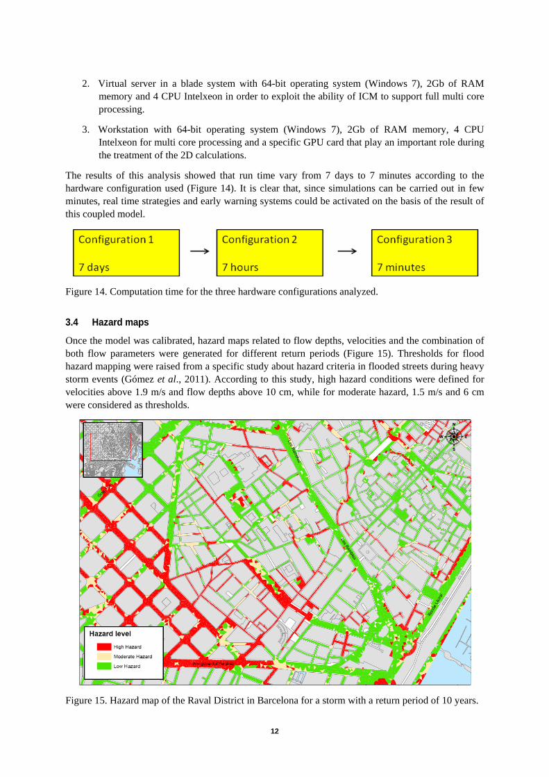
Once the model was calibrated, hazard maps related to flow depths, velocities and the combination of both flow parameters were generated for different return periods (Figure 15). Thresholds for flood hazard mapping were raised from a specific study about hazard criteria in flooded streets during heavy storm events (Gómez et al., 2011). According to this study, high hazard conditions were defined for velocities above 1.9 m/s and flow depths above 10 cm, while for moderate hazard, 1.5 m/s and 6 cm were considered as thresholds.
Figure 15. Hazard map of the Raval District in Barcelona for a storm with a return period of 10 years.

13
4 CONCLUSIONS In the framework of 7th FP CORFU project, the hydraulic behavior and flood resilience of a critical area of Barcelona (Raval District) is analyzed. A 1D/2D coupled model was developed and the interface between the two drainage layers was characterized through empirical expressions related to hydraulic performance of surface drainage systems. The 2D domain covers 44 km2 of the city land involving 235 km of sewers, while 2D mesh counts 403,925 triangles.
Calibration and validation of the model were based on the data (rain gauge data, time series of flow depths recorded by water level gauges, reports and videos concerning flooded areas) related to 4 heavy storm events occurred in 2011. The obtained results show that it is possible to reproduce the effects of urban floods in the Raval District in a more realistic way than traditional 1D sewer flow simulations. Flood hazard maps concerning specific hazard criteria related to flooding in urban areas, have been elaborated for several return periods.
Sensitivity analysis was carried out indicating the poor influence of the roughness and the discharge coefficient of the manholes on the 2D flow parameters. A specific analysis on the computational time proved that it is possible to carry out simulations in few minutes. This aspect allows to use simulation results for real time strategies and early warning systems.
The next step in this research is to incorporate the results of hydraulic modelling (for a range of scenarios) with the CORFU flood damage assessment tool (Hammond et al., 2012) that links flow depths with flood-damage curves for individual buildings. The results of this ongoing work will also be presented at the Conference.
5 ACKNOWLEDGEMENT Research on the CORFU (Collaborative research on flood resilience in urban areas) project was funded by the European Commission through Framework Programme 7, Grant Number 244047.
6 REFERENCES Alcrudo F. and Mulet-Marti J. (2005). Urban inundation models based upon the Shallow Water
equations. Numerical and practical issues. Proceedings of Finite Volumes for Complex Applications IV. Problems and Perspectives. Hermes Science publishing. pp 3-1. ISBN 1 905209 48 7.
Danish Hydraulic Institute (DHI) 2002. Calibration of MOUSE Urban Surface Runoff Models. Final Report, Waitakere City Council.
Djordjević S., Prodanović D., Maksimović C. (1999). An approach to simulation of dual drainage. Water Science and Technology, 39(9), 95-103.
Djordjević S., Saul A., Tabor G. R., Blanksby J., Galambos I., Sabtu I., Sailor G. (2011). Experimental and numerical investigation of interaction bewteen above and below ground drainage systems. Proceedings of 12th International Conference of Urban Drainage. Porto Alegre, Brazil.
Godunov S. K. (1959). A Difference Scheme for Numerical Solution of Discontinuous Solution of Hydrodynamic Equations. Math. Sbornik, 47, 271–306, translated US Joint Publ. Res. Service, JPRS 7226, 1969.

14
Gómez M. and Russo B. (2009). Hydraulic efficiency of continuous transverse grates for paved areas. Journal of Irrigation and Drainage Engineering. American Society of Civil Engineering (ASCE). 135(2), 225-230.
Gómez M., Macchione F. and Russo B. (2011). Methodologies to study the surface hydraulic behaviour of urban catchments during storm events. Water Science and Technology. IWA Publishing. 63(11), 2666-2673.
Gómez M. and Russo B. (2011). Methodology to estimate hydraulic efficiency of drain inlets. Proceedings of the ICE - Water Management. Institution of Civil Engineers, 164(1), 1-10.
Gómez M., Hidalgo G. and Russo B. (2012). Experimental campaign to determine grated inlet clogging factors in an urban catchment of Barcelona. Urban Water Journal. (In press).
Hammond M. J., Chen A. S., Djordjevic S., Butler D., Rahman S. M. M., Haque A. K. E. and Mark O. (2012). The development of a flood damage assessment tool for urban areas, 9th International Conferencew on Urban Drainage Modelling, Belgrade.
Innovyze (2012). InfoWorks ICM (Integrated Catchment Modeling) v.2.5. User manual references. Kandori C. and Willems P. (2008). Impact of the two-directional interaction of sewer and river
systems on the flood risk, 11th International Conference on Urban Drainage. Edinburgh, Scotland, UK.
Leandro J, Djordjević S, Chen A. and Savić D. (2007). The use of multiple-linking-element for connecting sewer and surface drainage networks. Proceedings of 32nd IAHR Congress, Venice, Italy.
Leandro J., Chen A., Djordjević S. and Savić D. (2009). Comparison of 1D/1D and 1D/2D Coupled (Sewer/Surface) Hydraulic Models for Urban Flood Simulation. Journal of Hydraulic Engineering. American Society of Civil Engineering (ASCE). 135(6), 495-504.
Lipeme Kouyi G., Fraisse D., Rivière N., Guinot V. and Chocat B. (2008). 1D modelling of the interactions between heavy rainfall-runoff in urban area and flooding flows from sewer network and river, 11th International Conference on Urban Drainage. Edinburgh, Scotland, UK.
Obermayer A., Guenthert F. W., Angermair G, Tandler R.,Braunschmidt S. and Milojevic N. (2010). Different approaches for modelling of sewer caused urban flooding, Water Science and Technology.62(9), 2175-82.
Phillips, Yu, Thompson & de Silva, 1D and 2D Modelling of Urban Drainage Systems using XP-SWMM and TUFLOW, 10th International Conference on Urban Drainage. Copenhagen, Denmark.
Schmitt, T. G., Thomas, M., and Ettrich N. (2004). Analysis and modeling of flooding in urban drainage systems. Journal of Hydrology, 299(3-4), 300-311.
Shepherd W., Blanksby J., Doncaster S. and T. Poole (2011). Quantifying the effect of buildings and surface roughness on 2D flood modelling. Proceedings of 12th International Conference of Urban Drainage. Porto Alegre, Brazil.

15
7 QUESTIONARY
1. Name of the author that will present the paper: BENIAMINO RUSSO
(please note that one author can have only one oral and one poster presentation at the Conference)
2. Is the first author an young researcher (according to IWA, under the age of 35): Yes
3. Have you submitted the extended abstract yet: No
If Yes, give the file name of extended abstract: ____________________________
4. Have you previously published this paper at another conference or Journal: No
5. Do you want to have the full paper offered for the Journal:
Water Science and Technology: Yes
Journal of Hydraulic Research: Yes
Other Journal: Urban Water Journal: Yes
6. Have you checked your paper for style, formatting and English language: Yes


